
Remote-Sensing-Based Prioritization of Post-Fire Restoration Actions in Mediterranean Ecosystems: A Case Study in Cyprus
 ,
,  , ,
, ,  , , ,
, , , 
Abstract
1. Introduction
2. Materials and Methods
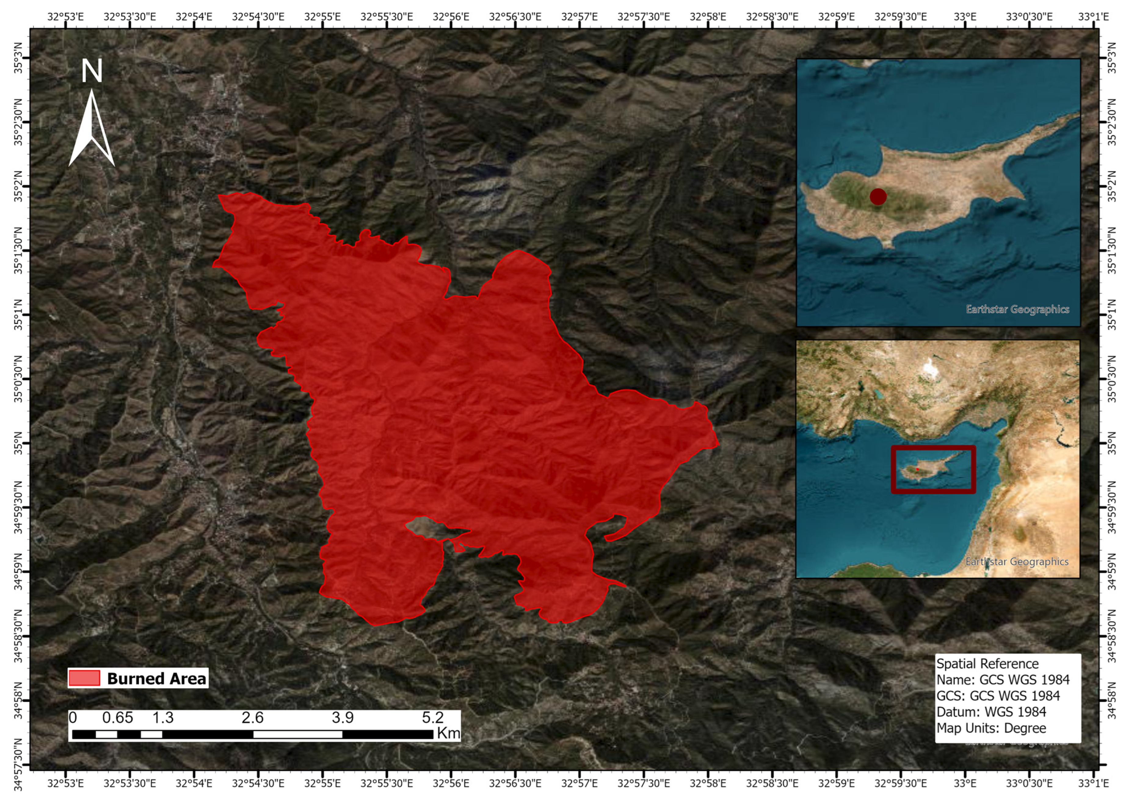
2.1. Study Area
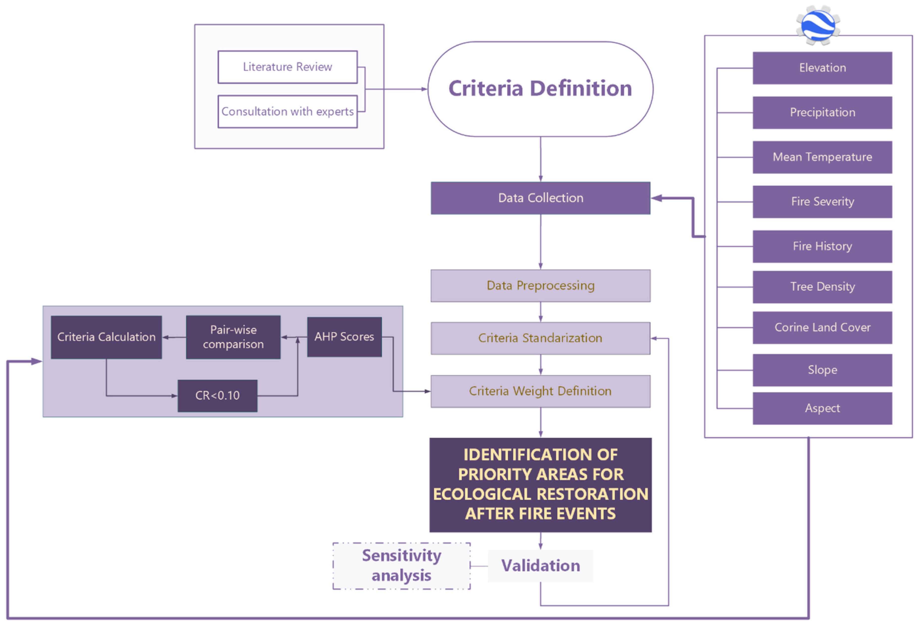
2.2. Methodology
2.2.1. Selection of Criteria
Criteria Standardization
Criteria Weight
Evaluation and Ranking Results
Validation of the Model
3. Results
3.1. Analytical Hierarchy Process (AHP) Results and Suitability Maps
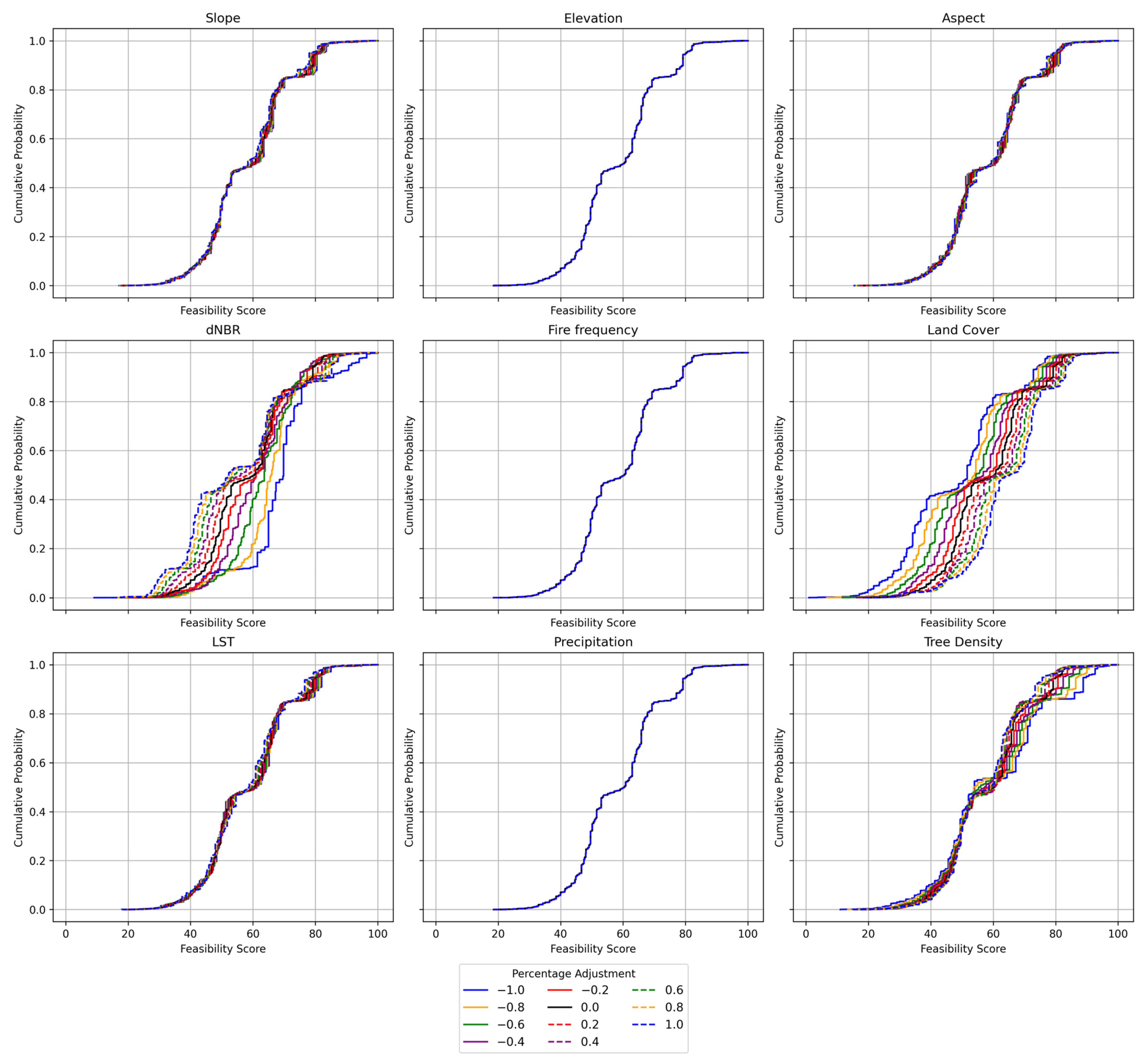
3.2. Sensitivity Analysis
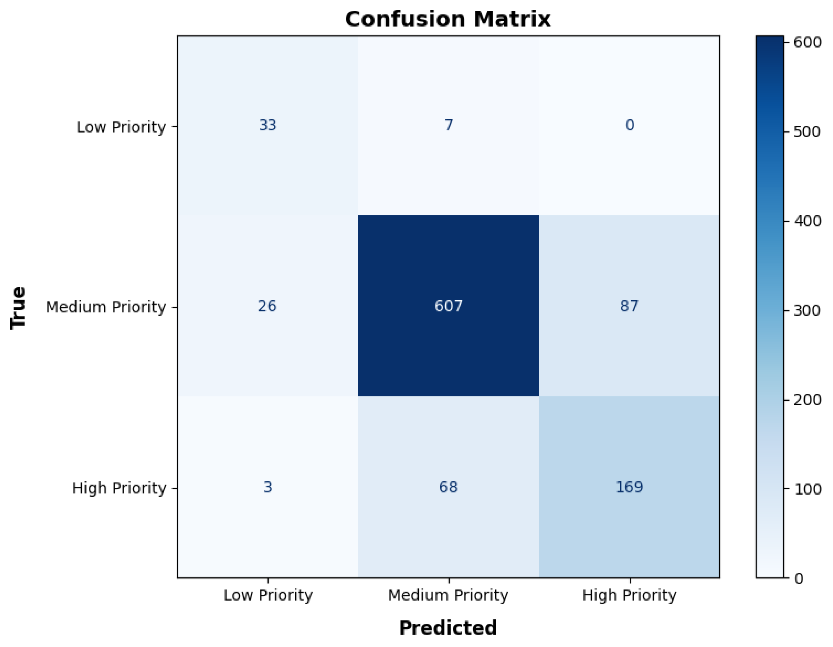
3.3. Validation of the Model
4. Discussion
Limitations of the Study and Future Work
5. Conclusions
Author Contributions
Funding
Data Availability Statement
Acknowledgments
Conflicts of Interest
References
- Pausas, J.G.; Vallejo, V.R. The Role of Fire in European Mediterranean Ecosystems. In Remote Sensing of Large Wildfires; Springer: Berlin/Heidelberg, Germany, 1999; pp. 3–16. [Google Scholar]
- Alayan, R.; Rotich, B.; Lakner, Z. A Comprehensive Framework for Forest Restoration after Forest Fires in Theory and Practice: A Systematic Review. Forests 2022, 13, 1354. [Google Scholar] [CrossRef]
- Anderegg, W.R.L.; Trugman, A.T.; Badgley, G.; Anderson, C.M.; Bartuska, A.; Ciais, P.; Cullenward, D.; Field, C.B.; Freeman, J.; Goetz, S.J.; et al. Climate-Driven Risks to the Climate Mitigation Potential of Forests. Science 2020, 368, eaaz7005. [Google Scholar] [CrossRef]
- Chiquier, S.; Patrizio, P.; Bui, M.; Sunny, N.; Mac Dowell, N. A Comparative Analysis of the Efficiency, Timing, and Permanence of CO 2 Removal Pathways. Energy Environ. Sci. 2022, 15, 4389–4403. [Google Scholar] [CrossRef]
- Psistaki, K.; Tsantopoulos, G.; Paschalidou, A.K. An Overview of the Role of Forests in Climate Change Mitigation. Sustainability 2024, 16, 6089. [Google Scholar] [CrossRef]
- UNEP/MAP. Plan Bleu State of the Environment and Development in the Mediterranean; UNEP: Nairobi, Kenya, 2020. [Google Scholar]
- Cantin, G.; Delahaye, B.; Funatsu, B.M. On the Degradation of Forest Ecosystems by Extreme Events: Statistical Model Checking of a Hybrid Model. Ecol. Complex. 2023, 53, 101039. [Google Scholar] [CrossRef]
- van Lierop, P.; Lindquist, E.; Sathyapala, S.; Franceschini, G. Global Forest Area Disturbance from Fire, Insect Pests, Diseases and Severe Weather Events. Ecol. Manag. 2015, 352, 78–88. [Google Scholar] [CrossRef]
- Bassi, S.; Kettunen, M. Forest Fires: Causes and Contributing Factors in Europe; European Parliament: Brussels, Belgium, 2008. [Google Scholar]
- MacCarthy, J.; Richter, J.; Tyukavina, S.; Weisse, M.; Harris, N. The Latest Data Confirms: Forest Fires Are Getting Worse; World Resources Institute: Washington, DC, USA, 2023; pp. 1–13. [Google Scholar]
- Prodromou, M.; Girtsou, S.; Leventis, G.; Koumoulidis, D.; Tzouvaras, M.; Mettas, C.; Apostolakis, A.; Kaskara, M.; Kontoes, H.; Hadjimitsis, D. Multimodal Dataset for Wildfire Risk Prediction in Cyprus. In Proceedings of the IGARSS 2024—IEEE International Geoscience and Remote Sensing Symposium, Athens, Greece, 7–12 July 2024; pp. 3332–3336. [Google Scholar]
- Nematshahi, S.; Khodaei, A.; Arabnya, A. Risk Assessment of Transmission Lines Against Grid-Ignited Wildfires. In Proceedings of the 2025 IEEE PES Grid Edge Technologies Conference & Exposition (Grid Edge), San Diego, CA, USA, 21–23 January 2025; pp. 1–5. [Google Scholar]
- Haque, M.K.; Azad, M.A.K.; Hossain, M.Y.; Ahmed, T.; Uddin, M.; Hossain, M.M. Wildfire in Australia during 2019-2020, Its Impact on Health, Biodiversity and Environment with Some Proposals for Risk Management: A Review. J. Environ. Prot. 2021, 12, 391–414. [Google Scholar] [CrossRef]
- Garcês, A.; Pires, I. The Hell of Wildfires: The Impact on Wildlife and Its Conservation and the Role of the Veterinarian. Conservation 2023, 3, 96–108. [Google Scholar] [CrossRef]
- Dijkstra, J.; Durrant, T.; San-Miguel-Ayanz, J.; Veraverbeke, S. Anthropogenic and Lightning Fire Incidence and Burned Area in Europe. Land 2022, 11, 651. [Google Scholar] [CrossRef]
- Giglio, L.; Boschetti, L.; Roy, D.P.; Humber, M.L.; Justice, C.O. The Collection 6 MODIS Burned Area Mapping Algorithm and Product. Remote Sens. Environ. 2018, 217, 72–85. [Google Scholar] [CrossRef]
- Lizundia-Loiola, J.; Otón, G.; Ramo, R.; Chuvieco, E. A Spatio-Temporal Active-Fire Clustering Approach for Global Burned Area Mapping at 250 m from MODIS Data. Remote Sens. Environ. 2020, 236, 111493. [Google Scholar] [CrossRef]
- Jones, H.P.; Jones, P.C.; Barbier, E.B.; Blackburn, R.C.; Rey Benayas, J.M.; Holl, K.D.; McCrackin, M.; Meli, P.; Montoya, D.; Mateos, D.M. Restoration and Repair of Earth’s Damaged Ecosystems. Proc. R. Soc. B Biol. Sci. 2018, 285, 20172577. [Google Scholar] [CrossRef]
- Martin, D.M. Ecological Restoration Should Be Redefined for the Twenty-first Century. Restor. Ecol. 2017, 25, 668–673. [Google Scholar] [CrossRef]
- Shilky; Ekka, P.; Upreti, M.; Kumar, A.; Saikia, P. Nature-Based Solutions and Ecological Urban Planning and Design for the Sustainable Urban Environments. In Earth Observation in Urban Monitoring; Elsevier: Amsterdam, The Netherlands, 2024; pp. 339–358. [Google Scholar]
- Uprety, Y.; Asselin, H.; Bergeron, Y.; Doyon, F.; Boucher, J.-F. Contribution of Traditional Knowledge to Ecological Restoration: Practices and Applications. Écoscience 2012, 19, 225–237. [Google Scholar] [CrossRef]
- Brancalion, P.H.S.; Chazdon, R.L. Beyond Hectares: Four Principles to Guide Reforestation in the Context of Tropical Forest and Landscape Restoration. Restor. Ecol. 2017, 25, 491–496. [Google Scholar] [CrossRef]
- Alloza, J.A.; Vallejo, R. Restoration of burned areas in forest management plans. In Desertification in the Mediterranean Region—A Security Issue; Springer: Dordrecht, The Netherlands, 2006; pp. 475–488. [Google Scholar]
- Cavalcante, R.B.L.; Nunes, S.; Viademonte, S.; Rodrigues, C.M.F.; Gomes, W.C.; da Silva Ferreira, J., Jr.; Pontes, P.R.M.; Giannini, T.C.; Awade, M.; Miranda, L.d.S.; et al. Multicriteria Approach to Prioritize Forest Restoration Areas for Biodiversity Conservation in the Eastern Amazon. J. Environ. Manag. 2022, 318, 115590. [Google Scholar] [CrossRef]
- Trabucchi, M.; Comín, F.A.; O’Farrell, P.J. Hierarchical Priority Setting for Restoration in a Watershed in NE Spain, Based on Assessments of Soil Erosion and Ecosystem Services. Reg. Environ. Change 2013, 13, 911–926. [Google Scholar] [CrossRef]
- Holl, K.D.; Crone, E.E.; Schultz, C.B. Landscape Restoration: Moving from Generalities to Methodologies. Bioscience 2003, 53, 491–502. [Google Scholar] [CrossRef]
- Morrison, E.B.; Lindell, C.A. Active or Passive Forest Restoration? Assessing Restoration Alternatives with Avian Foraging Behavior. Restor. Ecol. 2011, 19, 170–177. [Google Scholar] [CrossRef]
- Robichaud, P.R.; Lewis, S.A.; Brown, R.E.; Ashmun, L.E. Emergency Post-Fire Rehabilitation Treatment Effects on Burned Area Ecology and Long-Term Restoration. Fire Ecol. 2009, 5, 115–128. [Google Scholar] [CrossRef]
- Alayan, R.; Lakner, Z. Utilizing Comprehensive Criteria and Indicators for Post-Fire Forest Restoration in Spatial Decision Support Systems (SDSS). Forests 2024, 15, 386. [Google Scholar] [CrossRef]
- Papachristoforou, A.; Prodromou, M.; Hadjimitsis, D.; Christoforou, M. Detecting and Distinguishing between Apicultural Plants Using UAV Multispectral Imaging. PeerJ 2023, 11, e15065. [Google Scholar] [CrossRef] [PubMed]
- Prodromou, M.; Theocharidis, C.; Gitas, I.Z.; Eliades, F.; Themistocleous, K.; Papasavvas, K.; Dimitrakopoulos, C.; Danezis, C.; Hadjimitsis, D. Forest Habitat Mapping in Natura2000 Regions in Cyprus Using Sentinel-1, Sentinel-2 and Topographical Features. Remote Sens. 2024, 16, 1373. [Google Scholar] [CrossRef]
- Smith-Tripp, S.M.; Coops, N.C.; Mulverhill, C.; White, J.C.; Axelson, J. Landsat Assessment of Variable Spectral Recovery Linked to Post-Fire Forest Structure in Dry Sub-Boreal Forests. ISPRS J. Photogramm. Remote Sens. 2024, 208, 121–135. [Google Scholar] [CrossRef]
- Theocharidis, C.; Eliades, M.; Gitas, I.; Danezis, C.; Hadjimitsis, D. Monitoring Forest Dynamics between 1987–2023: An NDVI Analysis of Three Dominant Species in Paphos Forest, Cyprus. In Proceedings of SPIE Volume 13212, Proceedings of the 10th International Conference on Remote Sensing and Geoinformation of the Environment (RSCy2024), Paphos, Cyprus, 8–9 April 2024; Michaelides, S.C., Hadjimitsis, D.G., Danezis, C., Kyriakides, N., Christofe, A., Themistocleous, K., Schreier, G., Eds.; SPIE: San Diego, CA, USA, 13 September 2024; p. 13. [Google Scholar]
- Younes Cárdenas, N.; Joyce, K.E.; Maier, S.W. Monitoring Mangrove Forests: Are We Taking Full Advantage of Technology? Int. J. Appl. Earth Obs. Geoinf. 2017, 63, 1–14. [Google Scholar] [CrossRef]
- Pickell, P.D.; Hermosilla, T.; Frazier, R.J.; Coops, N.C.; Wulder, M.A. Forest Recovery Trends Derived from Landsat Time Series for North American Boreal Forests. Int. J. Remote Sens. 2016, 37, 138–149. [Google Scholar] [CrossRef]
- Tonini, M.; Pereira, M.G.; Parente, J.; Vega Orozco, C. Evolution of Forest Fires in Portugal: From Spatio-Temporal Point Events to Smoothed Density Maps. Nat. Hazards 2017, 85, 1489–1510. [Google Scholar] [CrossRef]
- Dosiou, A.; Athinelis, I.; Katris, E.; Vassalou, M.; Kyrkos, A.; Krassakis, P.; Parcharidis, I. Employing Copernicus Land Service and Sentinel-2 Satellite Mission Data to Assess the Spatial Dynamics and Distribution of the Extreme Forest Fires of 2023 in Greece. Fire 2024, 7, 20. [Google Scholar] [CrossRef]
- Pourtaghi, Z.S.; Pourghasemi, H.R.; Rossi, M. Forest Fire Susceptibility Mapping in the Minudasht Forests, Golestan Province, Iran. Environ. Earth Sci. 2015, 73, 1515–1533. [Google Scholar] [CrossRef]
- Almeida, C.T.d.; Galvão, L.S.; Ometto, J.P.H.B.; Jacon, A.D.; Pereira, F.R.d.S.; Sato, L.Y.; Silva-Junior, C.H.L.; Brancalion, P.H.S.; Aragão, L.E.O.e.C.d. Advancing Forest Degradation and Regeneration Assessment Through Light Detection and Ranging and Hyperspectral Imaging Integration. Remote Sens. 2024, 16, 3935. [Google Scholar] [CrossRef]
- Gitas, I.; Mitri, G.; Veraverbeke, S.; Polychronaki, A. Advances in Remote Sensing of Post-Fire Vegetation Recovery Monitoring—A Review. In Remote Sensing of Biomass—Principles and Applications; InTech: Rijeka, Croatia, 2012. [Google Scholar]
- Matt, J.E.; Underwood, K.L.; Diehl, R.M.; Lawson, K.S.; Worley, L.C.; Rizzo, D.M. Terrain-derived Measures for Basin Conservation and Restoration Planning. River Res. Appl. 2023, 39, 1795–1811. [Google Scholar] [CrossRef]
- Questad, E.J.; Kellner, J.R.; Kinney, K.; Cordell, S.; Asner, G.P.; Thaxton, J.; Diep, J.; Uowolo, A.; Brooks, S.; Inman-Narahari, N.; et al. Mapping Habitat Suitability for At-risk Plant Species and Its Implications for Restoration and Reintroduction. Ecol. Appl. 2014, 24, 385–395. [Google Scholar] [CrossRef]
- Koch, J.; Pearson, D.E.; Huebner, C.D.; Young, M.K.; Sniezko, R.A. Restoration of Landscapes and Habitats Affected by Established Invasive Species. In Invasive Species in Forests and Rangelands of the United States; Springer International Publishing: Cham, Switzerland, 2021; pp. 185–202. [Google Scholar]
- Weidlich, E.W.A.; Flórido, F.G.; Sorrini, T.B.; Brancalion, P.H.S. Controlling Invasive Plant Species in Ecological Restoration: A Global Review. J. Appl. Ecol. 2020, 57, 1806–1817. [Google Scholar] [CrossRef]
- Kulinan, A.S.; Cho, Y.; Park, M.; Park, S. Rapid Wildfire Damage Estimation Using Integrated Object-Based Classification with Auto-Generated Training Samples from Sentinel-2 Imagery on Google Earth Engine. Int. J. Appl. Earth Obs. Geoinf. 2024, 126, 103628. [Google Scholar] [CrossRef]
- Prodromou, M.; Gitas, I.; Themistocleous, K.; Danezis, C.; Ambrosia, V.; Hadjimitsis, D. The Use of Sentinel-2 Satellite Data for Burn Severity Mapping for Arakapas Fire Event in Cyprus. In Proceedings of the IGARSS 2023—2023 IEEE International Geoscience and Remote Sensing Symposium, Pasadena, CA, USA, 16–21 July 2023; IEEE: Piscataway, NJ, USA, 2023; pp. 2556–2559. [Google Scholar]
- Liu, C.-C.; Chen, Y.-H.; Wu, M.-H.M.; Wei, C.; Ko, M.-H. Assessment of Forest Restoration with Multitemporal Remote Sensing Imagery. Sci. Rep. 2019, 9, 7279. [Google Scholar] [CrossRef] [PubMed]
- Chen, X.; Vogelmann, J.E.; Rollins, M.; Ohlen, D.; Key, C.H.; Yang, L.; Huang, C.; Shi, H. Detecting Post-Fire Burn Severity and Vegetation Recovery Using Multitemporal Remote Sensing Spectral Indices and Field-Collected Composite Burn Index Data in a Ponderosa Pine Forest. Int. J. Remote Sens. 2011, 32, 7905–7927. [Google Scholar] [CrossRef]
- Viana-Soto, A.; Aguado, I.; Salas, J.; García, M. Identifying Post-Fire Recovery Trajectories and Driving Factors Using Landsat Time Series in Fire-Prone Mediterranean Pine Forests. Remote Sens. 2020, 12, 1499. [Google Scholar] [CrossRef]
- Chen, W.; Moriya, K.; Sakai, T.; Cao, C. Monitoring of Post-Fire Forest Recovery under Different Restoration Treatments Based on Time-Series ALOS/PALSAR Data. In Proceedings of the 2016 IEEE International Geoscience and Remote Sensing Symposium (IGARSS), Beijing, China, 10–15 July 2016; IEEE: Piscataway, NJ, USA, 2016; pp. 1749–1752. [Google Scholar]
- Hernández Clemente, R.; Navarro Cerrillo, R.M.; Gitas, I.Z. Monitoring Post-Fire Regeneration in Mediterranean Ecosystems by Employing Multitemporal Satellite Imagery. Int. J. Wildland Fire 2009, 18, 648–658. [Google Scholar] [CrossRef]
- Wang, R.; Sun, Y.; Zong, J.; Wang, Y.; Cao, X.; Wang, Y.; Cheng, X.; Zhang, W. Remote Sensing Application in Ecological Restoration Monitoring: A Systematic Review. Remote Sens. 2024, 16, 2204. [Google Scholar] [CrossRef]
- Salleh, M.R.M.; Ismail, Z.; Rahman, M.Z.A. Accuracy assessment of lidar-derived digital terrain model (DTM) with different slope and canopy cover in tropical forest region. ISPRS Ann. Photogramm. Remote Sens. Spat. Inf. Sci. 2015, II-2/W2, 183–189. [Google Scholar] [CrossRef]
- Nie, S.; Wang, C.; Xi, X.; Luo, S.; Li, G.; Tian, J.; Wang, H. Estimating the Vegetation Canopy Height Using Micro-Pulse Photon-Counting LiDAR Data. Opt. Express 2018, 26, A520. [Google Scholar] [CrossRef]
- Gupta, S.K.; Pandey, A.C. Spectral Aspects for Monitoring Forest Health in Extreme Season Using Multispectral Imagery. Egypt. J. Remote Sens. Space Sci. 2021, 24, 579–586. [Google Scholar] [CrossRef]
- Alves de Almeida, D.R.; Broadbent, E.; Almeyda Zambrano, A.M.; Ferreira, M.P.; Santin Brancalion, P.H. Fusion of Lidar and Hyperspectral Data from Drones for Ecological Questions: The Gatoreye Atlantic Forest Restoration Case Study. In Proceedings of the 2021 IEEE International Geoscience and Remote Sensing Symposium IGARSS, Brussels, Belgium, 11–16 July 2021; IEEE: Piscataway, NJ, USA, 2021; pp. 714–715. [Google Scholar]
- Zhao, A.; Zhang, A.; Liu, X.; Cao, S. Spatiotemporal Changes of Normalized Difference Vegetation Index (NDVI) and Response to Climate Extremes and Ecological Restoration in the Loess Plateau, China. Theor. Appl. Clim. 2018, 132, 555–567. [Google Scholar] [CrossRef]
- Reis, B.P.; Martins, S.V.; Fernandes Filho, E.I.; Sarcinelli, T.S.; Gleriani, J.M.; Marcatti, G.E.; Leite, H.G.; Halassy, M. Management Recommendation Generation for Areas Under Forest Restoration Process through Images Obtained by UAV and LiDAR. Remote Sens. 2019, 11, 1508. [Google Scholar] [CrossRef]
- Zhang, G.; Dong, J.; Xiao, X.; Hu, Z.; Sheldon, S. Effectiveness of Ecological Restoration Projects in Horqin Sandy Land, China Based on SPOT-VGT NDVI Data. Ecol. Eng. 2012, 38, 20–29. [Google Scholar] [CrossRef]
- Tang, J.; Liang, J.; Yang, Y.; Zhang, S.; Hou, H.; Zhu, X. Revealing the Structure and Composition of the Restored Vegetation Cover in Semi-Arid Mine Dumps Based on LiDAR and Hyperspectral Images. Remote Sens. 2022, 14, 978. [Google Scholar] [CrossRef]
- Saaty, T.L. A Scaling Method for Priorities in Hierarchical Structures. J. Math. Psychol. 1977, 15, 234–281. [Google Scholar] [CrossRef]
- Saaty, T.L. How to Make a Decision: The Analytic Hierarchy Process. Eur. J. Oper. Res. 1990, 48, 9–26. [Google Scholar] [CrossRef]
- Nesticò, A.; Passaro, R.; Maselli, G.; Somma, P. Multi-Criteria Methods for the Optimal Localization of Urban Green Areas. J. Clean. Prod. 2022, 374, 133690. [Google Scholar] [CrossRef]
- Paletto, A.; Pieratti, E.; De Meo, I.; Agnelli, A.E.; Cantiani, P.; Chiavetta, U.; Mazza, G.; Lagomarsino, A. A Multi-Criteria Analysis of Forest Restoration Strategies to Improve the Ecosystem Services Supply: An Application in Central Italy. Ann. Sci. 2021, 78, 7. [Google Scholar] [CrossRef]
- Curiel-Esparza, J.; Gonzalez-Utrillas, N.; Canto-Perello, J.; Martin-Utrillas, M. Integrating Climate Change Criteria in Reforestation Projects Using a Hybrid Decision-Support System. Environ. Res. Lett. 2015, 10, 094022. [Google Scholar] [CrossRef]
- Dosis, S.; Petropoulos, G.P.; Kalogeropoulos, K. A Geospatial Approach to Identify and Evaluate Ecological Restoration Sites in Post-Fire Landscapes. Land 2023, 12, 2183. [Google Scholar] [CrossRef]
- Arianoutsou, M.; Koukoulas, S.; Kazanis, D. Evaluating Post-Fire Forest Resilience Using GIS and Multi-Criteria Analysis: An Example from Cape Sounion National Park, Greece. Environ. Manag. 2011, 47, 384–397. [Google Scholar] [CrossRef] [PubMed]
- González, F.; Morante-Carballo, F.; González, A.; Bravo-Montero, L.; Benavidez-Silva, C.; Tedim, F. Assessment of Forest Fire Severity for a Management Conceptual Model: Case Study in Vilcabamba, Ecuador. Forests 2024, 15, 2210. [Google Scholar] [CrossRef]
- Hamidah, M.; Mohd Hasmadi, I.; Chua, L.S.L.; Yong, W.S.Y.; Lau, K.H.; Faridah-Hanum, I.; Pakhriazad, H.Z. Development of a Protocol for Malaysian Important Plant Areas Criterion Weights Using Multi-Criteria Decision Making—Analytical Hierarchy Process (MCDM-AHP). Glob. Ecol. Conserv. 2022, 34, e02033. [Google Scholar] [CrossRef]
- Derak, M.; Cortina, J. Multi-Criteria Participative Evaluation of Pinus Halepensis Plantations in a Semiarid Area of Southeast Spain. Ecol. Indic. 2014, 43, 56–68. [Google Scholar] [CrossRef]
- Rodman, K.C.; Fornwalt, P.J.; Chapman, T.B.; Coop, J.D.; Edwards, G.; Stevens, J.T.; Veblen, T.T. SRRT: A Decision Support Tool to Inform Postfire Reforestation of Ponderosa Pine and Douglas-Fir in the Southern Rocky Mountains; RMRS-RN-95; US Department of Agriculture, Forest Service, Rocky Mountain Research Station: Fort Collins, CO, USA, 2022; 12p.
- UNEP; FAO. The UN Decade on Ecosystem Restoration 2021–2030. UNEP/FAO Factsheet 2020, 2019, 4. [Google Scholar]
- Swati, H. Getting Started with the Bonn Challenge, United Nations Economic Commission for Europe, Switzerland. 2018. Available online: https://policycommons.net/artifacts/4855392/getting-started-with-the-bonn-challenge/5692337/ (accessed on 1 April 2025).
- Post-Fire Management Plan for the Burned Area of the Adelfi Forest; Department of Forests in Cyprus: Nicosia, Cyprus, 2016.
- Department of Forests in Cyprus Forest Fire Statistics for the Period 2000–2023: Number of Forest Fires and Burnt Areas for the Period 2000–2023 Causes of Forest Fires for the Period 2000–2023; Department of Forests in Cyprus: Nicosia, Cyprus, 2023.
- Department of Forests in Cyprus. Forest Fires. Available online: https://www.moa.gov.cy/moa/fd/fd.nsf/fd93_en/fd93_en?OpenDocument (accessed on 10 February 2025).
- Cardille, J.A.; Crowley, M.A.; Saah, D.; Clinton, N.E. (Eds.) Cloud-Based Remote Sensing with Google Earth Engine; Springer International Publishing: Cham, Switzerland, 2024; ISBN 978-3-031-26587-7. [Google Scholar]
- Gorelick, N.; Hancher, M.; Dixon, M.; Ilyushchenko, S.; Thau, D.; Moore, R. Google Earth Engine: Planetary-Scale Geospatial Analysis for Everyone. Remote Sens. Environ. 2017, 202, 18–27. [Google Scholar] [CrossRef]
- Mutanga, O.; Kumar, L. Google Earth Engine Applications. Remote Sens. 2019, 11, 591. [Google Scholar] [CrossRef]
- Pausas, J.G.; Ouadah, N.; Ferran, A.; Gimeno, T.; Vallejo, R. Fire Severity and Seedling Establishment in Pinus Halepensis Woodlands, Eastern Iberian Peninsula. Plant Ecol. 2002, 169, 205–213. [Google Scholar] [CrossRef]
- Rowe, J.S. Concepts of Fire Effects on Plant Individuals and Species. In The Role of Fire in Northern Circumpolar Ecosystems; John Wiley and Sons: New York, NY, USA, 1983; pp. 135–154. [Google Scholar]
- Pausas, J.G.; Bradstock, R.A.; Keith, D.A.; Keeley, J.E. Plant Functional Traits In Relation To Fire In Crown-Fire Ecosystems. Ecology 2004, 85, 1085–1100. [Google Scholar] [CrossRef]
- Cerdá, A.; Doerr, S.H. Influence of Vegetation Recovery on Soil Hydrology and Erodibility Following Fire: An 11-Year Investigation. Int. J. Wildland Fire 2005, 14, 423. [Google Scholar] [CrossRef]
- Khoirunisa, N.; Ku, C.-Y.; Liu, C.-Y. A GIS-Based Artificial Neural Network Model for Flood Susceptibility Assessment. Int. J. Environ. Res. Public Health 2021, 18, 1072. [Google Scholar] [CrossRef] [PubMed]
- Yilmaz, O.S.; Akyuz, D.E.; Aksel, M.; Dikici, M.; Akgul, M.A.; Yagci, O.; Balik Sanli, F.; Aksoy, H. Evaluation of Pre- and Post-Fire Flood Risk by Analytical Hierarchy Process Method: A Case Study for the 2021 Wildfires in Bodrum, Turkey. Landsc. Ecol. Eng. 2023, 19, 271–288. [Google Scholar] [CrossRef]
- Lu, L.; Xu, Y.; Huang, A.; Liu, C.; Marcos-Martinez, R.; Huang, L. Influences of Topographic Factors on Outcomes of Forest Programs and Policies in a Mountain Region of China: A Case Study. Mt. Res. Dev. 2020, 40, 848–860. [Google Scholar] [CrossRef]
- Jiang, K.; Li, Z.; Luo, C.; Wu, M.; Chao, L.; Zhou, Q.; Zhao, H. The Reduction Effects of Riparian Reforestation on Runoff and Nutrient Export Based on AnnAGNPS Model in a Small Typical Watershed, China. Environ. Sci. Pollut. Res. 2019, 26, 5934–5943. [Google Scholar] [CrossRef]
- Marden, M. Effectiveness of Reforestation in Erosion Mitigation and Implications for Future Sediment Yields, East Coast Catchments, New Zealand: A Review. N. Z. Geogr. 2012, 68, 24–35. [Google Scholar] [CrossRef]
- Hazarika, R.; Bolte, A.; Bednarova, D.; Chakraborty, D.; Gaviria, J.; Kanzian, M.; Kowalczyk, J.; Lackner, M.; Lstibůrek, M.; Longauer, R.; et al. Multi-Actor Perspectives on Afforestation and Reforestation Strategies in Central Europe under Climate Change. Ann. Sci. 2021, 78, 60. [Google Scholar] [CrossRef]
- Morales, N.S.; Fernández, I.C.; Duran, L.P.; Venegas-González, A. Community-driven Post-fire Restoration Initiatives in Central Chile: When Good Intentions Are Not Enough. Restor. Ecol. 2021, 29, e13389. [Google Scholar] [CrossRef]
- Orsi, F.; Geneletti, D. Identifying Priority Areas for Forest Landscape Restoration in Chiapas (Mexico): An Operational Approach Combining Ecological and Socioeconomic Criteria. Landsc. Urban. Plan. 2010, 94, 20–30. [Google Scholar] [CrossRef]
- Daskalakou, E.N.; Thanos, C.A. Postfire Regeneration of Aleppo Pine–Density, Survival and Early Growth of Pinus Halepensis Seedlings. In Proceedings of the MEDECOS Conference, Rhodes, Greece, 25 April–1 May 2004; pp. 1–10. [Google Scholar]
- Boydak, M. Silvicultural Characteristics and Natural Regeneration of Pinus brutia Ten.—A Review. Plant Ecol. 2004, 171, 153–163. [Google Scholar] [CrossRef]
- European Environment Agency. High Resolution Layer Tree Cover Density. Available online: https://land.copernicus.eu/en/products/high-resolution-layer-tree-cover-density (accessed on 20 February 2025).
- Fernandez, J.; Maillard, O.; Uyuni, G.; Guzmán-Rojo, M.; Escobar, M. Multi-Criteria Prioritization of Watersheds for Post-Fire Restoration Using GIS Tools and Google Earth Engine: A Case Study from the Department of Santa Cruz, Bolivia. Water 2023, 15, 3545. [Google Scholar] [CrossRef]
- Maillard, O.; Herzog, S.K.; Soria-Auza, R.W.; Vides-Almonacid, R. Impact of Fires on Key Biodiversity Areas (KBAs) and Priority Bird Species for Conservation in Bolivia. Fire 2022, 5, 4. [Google Scholar] [CrossRef]
- Shi, Y.-F.; Shi, S.-H.; Jiang, Y.-S.; Liu, J. A Global Synthesis of Fire Effects on Soil Seed Banks. Glob. Ecol. Conserv. 2022, 36, e02132. [Google Scholar] [CrossRef]
- Saaty, T. The Analytic Hierarchy Process (AHP) for Decision Making. In Proceedings of the 9th International Cryogenic Engineering Conference, Kobe, Japan, 11–14 May 1980; Volume 1, p. 69. [Google Scholar]
- Uribe, D.; Geneletti, D.; del Castillo, R.; Orsi, F. Integrating Stakeholder Preferences and GIS-Based Multicriteria Analysis to Identify Forest Landscape Restoration Priorities. Sustainability 2014, 6, 935–951. [Google Scholar] [CrossRef]
- Retalis, A.; Katsanos, D.; Tymvios, F.; Michaelides, S. Comparison of GPM IMERG and TRMM 3B43 Products over Cyprus. Remote Sens. 2020, 12, 3212. [Google Scholar] [CrossRef]
- Petrou, P.; Stampoulidis, A.; Pipinis, E.; Kitikidou, K.; Milios, E. Analysis of the Environments Where Natural Regeneration Is Established in the Absence of a Wildfire in the Open Pinus Brutia Forests in the Middle Elevations of the Central Part of Cyprus. Forests 2024, 15, 1228. [Google Scholar] [CrossRef]
- Van Duong, D.; Schimleck, L. Prediction of Static Bending Properties of Eucalyptus Clones Using Stress Wave Measurements on Standing Trees, Logs and Small Clear Specimens. Forests 2022, 13, 1728. [Google Scholar] [CrossRef]
- Nurda, N.; Noguchi, R.; Ahamed, T. Change Detection and Land Suitability Analysis for Extension of Potential Forest Areas in Indonesia Using Satellite Remote Sensing and GIS. Forests 2020, 11, 398. [Google Scholar] [CrossRef]
- Sismanis, M.; Gitas, I.Z.; Georgopoulos, N.; Stavrakoudis, D.; Gkounti, E.; Antoniadis, K. A Spectral–Spatial Approach for the Classification of Tree Cover Density in Mediterranean Biomes Using Sentinel-2 Imagery. Forests 2024, 15, 2025. [Google Scholar] [CrossRef]
- Key, C.H.; Benson, N.C. Landscape Assessment (LA) Sampling and Analysis Methods. In USDA Forest Service—General Technical Report RMRS-GTR; US Department of Agriculture, Forest Service: Collins, CO, USA, 2006. [Google Scholar]
- Bhattacharya, S.; Ghosh, S.; Bhattacharyya, S. Analytical Hierarchy Process Tool in Google Earth Engine Platform: A Case Study of a Tropical Landfill Site Suitability. Environ. Monit. Assess. 2022, 194, 276. [Google Scholar] [CrossRef] [PubMed]
- Ali, S.A.; Ahmad, A. Suitability Analysis for Municipal Landfill Site Selection Using Fuzzy Analytic Hierarchy Process and Geospatial Technique. Environ. Earth Sci. 2020, 79, 227. [Google Scholar] [CrossRef]
- Yağcı, C.; İşcan, F. Turkish Journal of Geographic Information Systems GIS-Based Site Suitability Analysis of Afforestation in Konya Province, Turkey. Turk. J. Geogr. Inf. Syst. 2021, 3, 89–95. [Google Scholar]
- Cruz-Bello, G.M.; Sotelo-Ruiz, E.D. Coupling Spatial Multiattribute Analysis and Optimization to Identify Reforestation Priority Areas. Mt. Res. Dev. 2013, 33, 29–39. [Google Scholar] [CrossRef]
- Congalton, R.G.; Green, K. Assessing the Accuracy of Remotely Sensed Data; CRC Press: Boca Raton, FL, USA, 2019; ISBN 9780429052729. [Google Scholar]
- Stehman, S.V. Selecting and Interpreting Measures of Thematic Classification Accuracy. Remote Sens. Environ. 1997, 62, 77–89. [Google Scholar] [CrossRef]
- Buckland, M.; Gey, F. The Relationship between Recall and Precision. J. Am. Soc. Inf. Sci. 1994, 45, 12–19. [Google Scholar] [CrossRef]
- Praticò, S.; Solano, F.; Di Fazio, S.; Modica, G. Machine Learning Classification of Mediterranean Forest Habitats in Google Earth Engine Based on Seasonal Sentinel-2 Time-Series and Input Image Composition Optimisation. Remote Sens. 2021, 13, 586. [Google Scholar] [CrossRef]
- Lu, D.; Weng, Q. A Survey of Image Classification Methods and Techniques for Improving Classification Performance. Int. J. Remote Sens. 2007, 28, 823–870. [Google Scholar] [CrossRef]
- Nikhil, S.; Danumah, J.H.; Saha, S.; Prasad, M.K.; Rajaneesh, A.; Mammen, P.C.; Ajin, R.S.; Kuriakose, S.L. Application of GIS and AHP Method in Forest Fire Risk Zone Mapping: A Study of the Parambikulam Tiger Reserve, Kerala, India. J. Geovisualization Spat. Anal. 2021, 5, 14. [Google Scholar] [CrossRef]
- Tolche, A.D.; Gurara, M.A.; Pham, Q.B.; Anh, D.T. Modelling and Accessing Land Degradation Vulnerability Using Remote Sensing Techniques and the Analytical Hierarchy Process Approach. Geocarto Int. 2022, 37, 7122–7142. [Google Scholar] [CrossRef]
- Yesilnacar, E.; Topal, T. Landslide Susceptibility Mapping: A Comparison of Logistic Regression and Neural Networks Methods in a Medium Scale Study, Hendek Region (Turkey). Eng. Geol. 2005, 79, 251–266. [Google Scholar] [CrossRef]
- Mamouri, R.-E.; Ansmann, A.; Ohneiser, K.; Knopf, D.A.; Nisantzi, A.; Bühl, J.; Engelmann, R.; Skupin, A.; Seifert, P.; Baars, H.; et al. Wildfire Smoke Triggers Cirrus Formation: Lidar Observations over the Eastern Mediterranean. Atmos. Chem. Phys. 2023, 23, 14097–14114. [Google Scholar] [CrossRef]
- Nisantzi, A.; Mamouri, R.E.; Ansmann, A.; Hadjimitsis, D. Injection of Mineral Dust into the Free Troposphere during Fire Events Observed with Polarization Lidar at Limassol, Cyprus. Atmos. Chem. Phys. 2014, 14, 12155–12165. [Google Scholar] [CrossRef]
- Pérez-Cabello, F.; Montorio, R.; Alves, D.B. Remote Sensing Techniques to Assess Post-Fire Vegetation Recovery. Curr. Opin. Environ. Sci. Health 2021, 21, 100251. [Google Scholar] [CrossRef]
- Pérez-Cabello, F.; Ibarra, P.; Echeverría, M.T.; de la Riva, J. Post-fire Land Degradation of Pinus sylvestris L. Woodlands after 14 Years. Land Degrad. Dev. 2010, 21, 145–160. [Google Scholar] [CrossRef]
- Ermitão, T.; Gouveia, C.M.; Bastos, A.; Russo, A.C. Recovery Following Recurrent Fires Across Mediterranean Ecosystems. Glob. Change Biol. 2024, 30, e70013. [Google Scholar] [CrossRef]
- Giglio, L.; Schroeder, W.; Justice, C.O. The Collection 6 MODIS Active Fire Detection Algorithm and Fire Products. Remote Sens. Environ. 2016, 178, 31–41. [Google Scholar] [CrossRef]
- Casisirano, J.; Tuminting, M.; Ramos, R.V.; Medina, J.M. Tree Planting Prioritization in National Capital Region, Philippines Using Remote Sensing, Analytic Hierarchy Process and Gis. Int. Arch. Photogramm. Remote Sens. Spat. Inf. Sci. 2024, XLVIII-4/W, 121–127. [Google Scholar] [CrossRef]
- González-De Vega, S.; De las Heras, J.; Moya, D. Resilience of Mediterranean Terrestrial Ecosystems and Fire Severity in Semiarid Areas: Responses of Aleppo Pine Forests in the Short, Mid and Long Term. Sci. Total Environ. 2016, 573, 1171–1177. [Google Scholar] [CrossRef]
- Roche, P.K.; Campagne, C.S.; Ganteaume, A. Post-Fire Recovery Dynamics and Resilience of Ecosystem Services Capacity in Mediterranean-Type Ecosystems. Ecosystems 2024, 27, 833–847. [Google Scholar] [CrossRef]
- Hernández-Duarte, A.; Saavedra, F.; González, E.; Miranda, A.; Francois, J.-P.; Somos-Valenzuela, M.; Sibold, J. Effects of Drought and Fire Severity Interaction on Short-Term Post-Fire Recovery of the Mediterranean Forest of South America. Fire 2024, 7, 428. [Google Scholar] [CrossRef]
- Fernandez-Manso, A.; Quintano, C.; Roberts, D.A. Burn Severity Influence on Post-Fire Vegetation Cover Resilience from Landsat MESMA Fraction Images Time Series in Mediterranean Forest Ecosystems. Remote Sens. Environ. 2016, 184, 112–123. [Google Scholar] [CrossRef]
- White, A.M.; Long, J.W. Understanding Ecological Contexts for Active Reforestation Following Wildfires. New For. 2019, 50, 41–56. [Google Scholar] [CrossRef]
- Wang, X.; He, H.S.; Li, X.; Chang, Y.; Hu, Y.; Xu, C.; Bu, R.; Xie, F. Simulating the Effects of Reforestation on a Large Catastrophic Fire Burned Landscape in Northeastern China. Ecol. Manag. 2006, 225, 82–93. [Google Scholar] [CrossRef]
- Dobrowski, S.Z.; Aghai, M.M.; Chichilnisky du Lac, A.; Downer, R.; Fargione, J.; Haase, D.L.; Hoecker, T.; Kildisheva, O.A.; Murdoch, A.; Newman, S.; et al. ‘Mind the Gap’—Reforestation Needs vs. Reforestation Capacity in the Western United States. Front. For. Glob. Change 2024, 1402124. [Google Scholar] [CrossRef]
- Xiao, D.; Tao, D.; Xu, Z. Impacts of an Extra-Ordinarily Disastrous Fire on Forest Resources and Environment. Chin. J. Ecol. 1988, 7, 5–9. [Google Scholar]
- Chen, W.; Moriya, K.; Sakai, T.; Koyama, L.; Cao, C. Post-Fire Forest Regeneration under Different Restoration Treatments in the Greater Hinggan Mountain Area of China. Ecol. Eng. 2014, 70, 304–311. [Google Scholar] [CrossRef]
- Vedovato, L.B.; Aragão, L.E.O.C.; Almeida, D.R.A.; Bartholomew, D.C.; Assis, M.; Dalagnol, R.; Gorgens, E.B.; Silva-Junior, C.H.L.; Ometto, J.P.; Pontes-Lopes, A.; et al. Impacts of Fire on Canopy Structure and Its Resilience Depend on Successional Stage in Amazonian Secondary Forests. Remote Sens. Ecol. Conserv. 2025. [Google Scholar] [CrossRef]
- Tucker, M.M.; Kashian, D.M. Pre-Fire Forest Remnants Affect Post-Fire Plant Community Structure and Composition. Ecol. Manag. 2018, 408, 103–111. [Google Scholar] [CrossRef]
- Harvey, B.J.; Donato, D.C.; Turner, M.G. High and Dry: Post-fire Tree Seedling Establishment in Subalpine Forests Decreases with Post-fire Drought and Large Stand-replacing Burn Patches. Glob. Ecol. Biogeogr. 2016, 25, 655–669. [Google Scholar] [CrossRef]
- Yao, J.; Kong, X.; Fang, L.; Huo, Z.; Peng, Y.; Han, Z.; Ren, S.; Chen, J.; Wang, X.; Wang, Q. Drivers of Structural and Functional Resilience Following Extreme Fires in Boreal Forests of Northeast China. Fire 2025, 8, 108. [Google Scholar] [CrossRef]
- Laughlin, M.M.; Rangel-Parra, L.K.; Morris, J.E.; Donato, D.C.; Halofsky, J.S.; Harvey, B.J. Patterns and Drivers of Early Conifer Regeneration Following Stand-Replacing Wildfire in Pacific Northwest (USA) Temperate Maritime Forests. Ecol. Manag. 2023, 549, 121491. [Google Scholar] [CrossRef]
- Cordell, S.; Questad, E.J.; Asner, G.P.; Kinney, K.M.; Thaxton, J.M.; Uowolo, A.; Brooks, S.; Chynoweth, M.W. Remote Sensing for Restoration Planning: How the Big Picture Can Inform Stakeholders. Restor. Ecol. 2017, 25, S147–S154. [Google Scholar] [CrossRef]
- Menéndez-Miguélez, M.; Rubio-Cuadrado, Á.; Cañellas, I.; Erdozain, M.; de Miguel, S.; Lapin, K.; Hoffmann, J.; Werden, L.; Alberdi, I. How to Measure Outcomes in Forest Restoration? A European Review of Success and Failure Indicators. Front. For. Glob. Change 2024, 7, 1420127. [Google Scholar] [CrossRef]


| Criteria | Description | Source |
|---|---|---|
| Topographic information (Elevation, slope, aspect) | Topography influences both surface runoff dynamics and ecological patterns [84,85]. Lower elevation presents slower flow rates than higher elevations, leading to water accumulation in valleys, which can impact climate conditions, vegetation types, species distribution, and ecological recovery [86]. Steeper slopes present unique challenges, including higher risks of soil erosion, increased water runoff speeds, and changes in soil moisture retention, all of which influence tree species selection and survival rates, [87,88] as well as complicating logistics [89]. The steep areas also present a higher risk of landslides and floods [90]. Additionally, the aspect can influence microclimate conditions like sunlight exposure and moisture levels; for example, east-facing slopes receive more incoming solar radiation in mountainous areas, which helps in selecting sites that can support vegetation regeneration [38,66]. | SRTM (GEE) |
| Land cover | The land cover and the proximity to forests were used because this study focused on restoring forested and vegetated areas. Also, the proximity to forest areas was prioritized due to their proximity to reservoirs of native species [91]. | Corine Land Cover/ESA World Cover (GEE) |
| Tree density | The regeneration of both species and forest dependent on the canopy seed bank [92]. In this study, the tree density was utilized, due to the assumption that in denser forests, there is larger seed production [93]. | Copernicus Land [94] |
| Vulnerability to wildfire hazards | In terms of vulnerability to wildfire hazards, the analysis considered the burn severity and fire frequency. Specifically, in this study, it was assumed that the burn severity and the fire frequency could determine the potential for natural regeneration, suggesting that active restoration actions should prioritize ecosystems most heavily impacted by fires [95,96]. Additionally, burn severity influences soil quality and seed bank viability. High-severity fires can destroy seed banks and soil structures, leading to artificial reforestation actions with resilient species, while lower severity fires might allow for natural regeneration [97]. | Sentinel-2 (GEE) Fire frequency (EFFIS) |
| Meteorological factors (mean temperature and total precipitation) | The meteorological factors were selected to identify suitable conditions for the growth of the majority of the species. For example, high altitudes due to lower temperatures are ideal for many species. Additionally, the precipitation and temperature variations depend on the aspect [24]. | Temperature: MODIS (GEE) Precipitation: CHIRPS(GEE) |
| Criteria | Excluded | Low | Medium | High | Source | |
|---|---|---|---|---|---|---|
| Topographic information | Elevation (m) | 0–300 (coastal/ plain) | 300–500 (hilly) | >500 (semi-mountainous – mountainous) | [100] | |
| Aspect (°) | N, NE, NW | E, SE | S, SE, W | [66,86] | ||
| Slope (°) | >25 | 10–25 | 0–10 | [85,101] | ||
| Land cover | Corine land cover | Non- vegetated | Grasslands and shrublands | - | Forests | [95,102,103] |
| Tree density (%) | >70 | 15–70 | <15 | [104] | ||
| Vulnerability to wildfire hazards | Fire history (reoccurrence) | 1 | 2 | >3 | [95] | |
| Fire Severity (* dNBR— Sentinel-2) | ≤100 | 100–270 | 270–440 | ≥440 | [105] | |
| Meteorological factors | Precipitation (mm) | >700 | 400–700 | <400 | [106] | |
| Temperature (°C) | 10–28.95 | 28.95–32.04 | >32.04 | [106,107] | ||
| Intensity of Importance | Remark |
|---|---|
| 1 | Equal importance |
| 3 | Moderately more important |
| 5 | Strongly more important |
| 7 | Very strongly more important |
| 9 | Extremely more important |
| 2, 4, 6, 8 | Intermediate values |
| n | 1 | 2 | 3 | 4 | 5 | 6 | 7 | 8 | 9 | 10 |
|---|---|---|---|---|---|---|---|---|---|---|
| Random Consistency Index (RI) | 0 | 0 | 0.58 | 0.9 | 1.12 | 1.24 | 1.32 | 1.41 | 1.45 | 1.49 |
| (1) | (2) | (3) | (4) | (5) | (6) | (7) | (8) | (9) | |
|---|---|---|---|---|---|---|---|---|---|
| (1) Fire Severity | 1.00 | 5.00 | 2.00 | 3.00 | 5.00 | 7.00 | 7.00 | 5.00 | 5.00 |
| (2) Fire History | 0.20 | 1.00 | 0.33 | 0.33 | 3.00 | 4.00 | 4.00 | 3.00 | 3.00 |
| (3) Tree Density | 0.50 | 3.00 | 1.00 | 2.00 | 6.00 | 7.00 | 7.00 | 5.00 | 5.00 |
| (4) Land Cover | 0.33 | 3.00 | 0.50 | 1.00 | 5.00 | 6.00 | 6.00 | 4.00 | 4.00 |
| (5) Slope | 0.20 | 0.33 | 0.17 | 0.20 | 1.00 | 2.00 | 2.00 | 0.33 | 0.33 |
| (6) Elevation | 0.14 | 0.25 | 0.14 | 0.17 | 0.50 | 1.00 | 1.00 | 0.33 | 0.33 |
| (7) Aspect | 0.14 | 0.25 | 0.14 | 0.17 | 0.50 | 1.00 | 1.00 | 0.33 | 0.33 |
| (8) Precipitation | 0.20 | 0.33 | 0.20 | 0.25 | 3.00 | 3.00 | 3.00 | 1.00 | 1.00 |
| (9) Temperature | 0.20 | 0.33 | 0.20 | 0.25 | 3.00 | 3.00 | 3.00 | 1.00 | 1.00 |
| = 9.761 | CI = 0.095 | CR = 7% | |||||||
| Priority | Area (Km2) | |
|---|---|---|
| DoF | GRESTO | |
| Low | 0.71 | 1.64 |
| High | 4.10 | 4.19 |
| Medium | 12.49 | 11.47 |
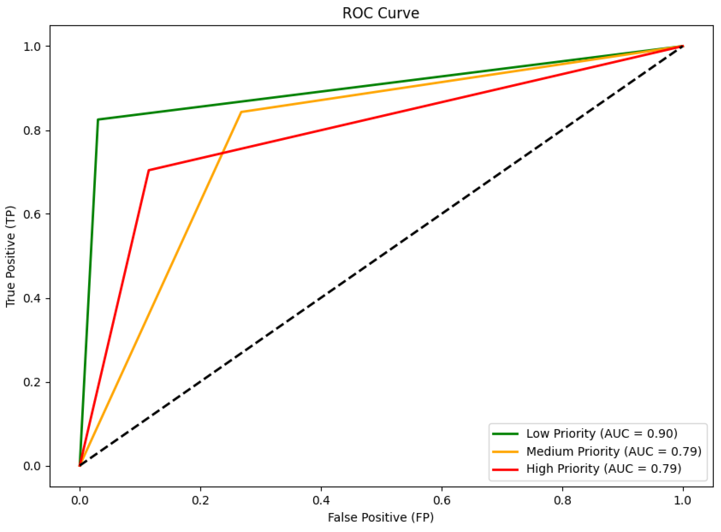
| Priority Class | Precision | Recall | F1-Score |
|---|---|---|---|
| Low | 0.53 | 0.83 | 0.65 |
| Medium | 0.89 | 0.84 | 0.87 |
| High | 0.66 | 0.70 | 0.68 |
| Accuracy | 0.81 | ||
Disclaimer/Publisher’s Note: The statements, opinions and data contained in all publications are solely those of the individual author(s) and contributor(s) and not of MDPI and/or the editor(s). MDPI and/or the editor(s) disclaim responsibility for any injury to people or property resulting from any ideas, methods, instructions or products referred to in the content. |
© 2025 by the authors. Licensee MDPI, Basel, Switzerland. This article is an open access article distributed under the terms and conditions of the Creative Commons Attribution (CC BY) license (https://creativecommons.org/licenses/by/4.0/).
Share and Cite
Prodromou, M.; Gitas, I.; Mettas, C.; Tzouvaras, M.; Themistocleous, K.; Konstantinidis, A.; Pamboris, A.; Hadjimitsis, D. Remote-Sensing-Based Prioritization of Post-Fire Restoration Actions in Mediterranean Ecosystems: A Case Study in Cyprus. Remote Sens. 2025, 17, 1269. https://doi.org/10.3390/rs17071269
Prodromou M, Gitas I, Mettas C, Tzouvaras M, Themistocleous K, Konstantinidis A, Pamboris A, Hadjimitsis D. Remote-Sensing-Based Prioritization of Post-Fire Restoration Actions in Mediterranean Ecosystems: A Case Study in Cyprus. Remote Sensing. 2025; 17(7):1269. https://doi.org/10.3390/rs17071269
Chicago/Turabian StyleProdromou, Maria, Ioannis Gitas, Christodoulos Mettas, Marios Tzouvaras, Kyriacos Themistocleous, Andreas Konstantinidis, Andreas Pamboris, and Diofantos Hadjimitsis. 2025. "Remote-Sensing-Based Prioritization of Post-Fire Restoration Actions in Mediterranean Ecosystems: A Case Study in Cyprus" Remote Sensing 17, no. 7: 1269. https://doi.org/10.3390/rs17071269
APA StyleProdromou, M., Gitas, I., Mettas, C., Tzouvaras, M., Themistocleous, K., Konstantinidis, A., Pamboris, A., & Hadjimitsis, D. (2025). Remote-Sensing-Based Prioritization of Post-Fire Restoration Actions in Mediterranean Ecosystems: A Case Study in Cyprus. Remote Sensing, 17(7), 1269. https://doi.org/10.3390/rs17071269