Review

Sustainable Urban Land Management Based on Earth Observation Data—State of the Art and Trends

by
Elzbieta Bielecka
1,*,
Anna Markowska
2,
Barbara Wiatkowska
3 and
Beata Calka
1
1
Faculty of Civil Engineering and Geodesy, Military University of Technology, 00-908 Warsaw, Poland
2
Remote Sensing Centre, Institute of Geodesy and Cartography, 02-679 Warsaw, Poland
3
Department of Geodesy and Geoinformatics, Wroclaw University of Science and Technology, 50-370 Wroclaw, Poland
*
Author to whom correspondence should be addressed.
Remote Sens. 2025, 17(9), 1537; https://doi.org/10.3390/rs17091537 (registering DOI)
Submission received: 12 February 2025 / Revised: 17 April 2025 / Accepted: 24 April 2025 / Published: 26 April 2025
(This article belongs to the Section Environmental Remote Sensing)

Abstract

:
This paper aims to analyze and synthesize research on sustainable urban land management (SULM) based on earth observation (EO) data. Particular attention is given to the intellectual foundations and emerging trends in the field. We conducted a search in the Web of Science database, identifying over 1600 research papers, primarily journal articles and conference proceedings. A systematic review methodology was employed for both quantitative analysis (e.g., trends in SULM research over time, distribution by country, journal impact, etc.) and qualitative analysis (e.g., intellectual foundations, emerging trends, and research limitations). An analysis of the 50 most cited publications revealed two main research streams, environmental and technological. The environmental one focuses on the assessment and monitoring of ecosystem services and land use change as a key driver of climate change and its environmental impacts, while the technological stream highlights the role of remote sensing and geospatial technologies and their fusion to develop better, more tailored models and indicators. The researchers also highlight the differences in analytical methodology, depending on the scale of the study. Based on a thorough analysis of the scientific literature, we concluded that sustainable land management, especially in urban areas, is currently the only concept that provides the basis for human survival on earth. Furthermore, monitoring SULM and assessing its changes are immensely difficult without earth observation data.

1. Introduction

The concept of sustainable land management (SLM) originates from the broader discourse on population growth and resource use, dating back to the late 18th century. In 1798, Thomas Malthus published his seminal work, An Essay on the Principle of Population, in which he argued that population growth tends to outpace the availability of resources [1]. Malthus’ observation remains relevant in today’s overpopulated world, where the relentless exploitation of resources leaves little time for their natural regeneration. The environmental impact of human activities began to be formally recognized in the late 1950s and 1960s, a period marked by growing public awareness and, in consequence, concern about damage to the natural environment. The term “sustainable development” first appeared in an official document in 1969, endorsed by thirty-three African nations under the auspices of the International Union for Conservation of Nature (IUCN) [2]. In the same year, the United States Congress debated the need for a national environmental policy, which culminated in the enactment of the National Environmental Policy Act (NEPA) in 1969. Signed into law by President Nixon on 1 January 1970, NEPA was a pioneering statute among several major environmental laws of the 1970s [3]. The modern understanding of sustainability was significantly shaped by the document Our Common Future, commonly known as the 1987 Brundtland Report. This report, prepared by the World Commission on Environment and Development (WCED) under the leadership of Gro Harlem Brundtland, defined sustainable development as “meeting the needs of the present without compromising the ability of future generations to meet their own needs” [4] and constituted a landmark in sustainable development. The report made several key recommendations to promote sustainable development aimed at addressing the interconnectedness of environmental, economic, and social issues, emphasizing the need for a holistic approach to development. While Our Common Future has had a lasting impact on global sustainability efforts, fully achieving its recommendations remains an ongoing challenge. Subsequent global summits, namely, the Earth Summit in Rio de Janeiro in 1992 and the Johannesburg Summit in 2002, were crucial, as their recommendations led to important agreements: Agenda 21, followed by the Sustainable Development Goals (SDGs in Agenda 2030), adopted in 2015 [5]. The Sustainable Development Goals include 17 goals, several of which focus on sustainable urban development, with SDG 11 being the most prominent. SDG 11 aims to “make cities and human settlements inclusive, safe, resilient, and sustainable”. Additionally, urban components are integrated into other SDGs, such as SDG 1 (No Poverty), SDG 6 (Clean Water and Sanitation), and SDG 13 (Climate Action).
Progress in SLM should be monitored using clearly defined indicators, with threshold values and necessary data specified for calculation and implementation [6]. Despite the existence of SLM indices, innovative technologies that provide pertinent geographical and statistical data remain of utmost importance. Remote sensing (RS) data play a key role due to their digital nature, global coverage, and increasingly high spatial, spectral, and radiometric resolution. Geoinformation technologies, by contrast, apply advanced data processing methods and offer products based on earth observation data to support sustainability monitoring and goal achievement. The most notable RS products include maps and data on land cover/land use, gridded population distribution, air temperature, water resources, and soil and air pollution.
With the global urban area expanding by approximately 9687 km2 between 1985 and 2015 [7], monitoring the sustainable management of urban areas has become increasingly important. Increased migration to cities has led to rapid urbanization, resulting in changes to the local climate and environment [8]. Such urban growth exposes cities to a number of environmental problems [9], including heat islands, noise, various forms of pollution (air, soil, water), loss of biodiversity, and, ultimately, the degradation of urban ecosystems and threats to ecosystem services and human health.
Academic and public interest in sustainable land management has been growing for at least three decades. Studies on urban SLM tend to focus on a single city, cities within a single country, or cities in a specific region. Few studies have analyzed SLM in urban areas on a global scale. Most of these studies employ earth observation data and geographic information systems (GISs), with some using more advanced geoinformation technologies. Despite the abundance of empirical and academic research on this global issue, systematic literature reviews remain scarce [8,9]. Our research aims to fill this gap by synthesizing research efforts on how earth observation data supports sustainable urban planning and management. This study systematically reviews research publications indexed in the Web of Science Core Collection using a bibliometric approach to analyze the role of EO data in sustainable urban land management. The results make an important contribution to the discourse on the usability of remote sensing data and product usability in assessing and monitoring sustainable land management. Specifically, this study aims to identify key topics, research trends, the intellectual foundations of the field, emerging developments, and major challenges based on the prominent literature.
The next section explores key ideas of sustainable urban land management (SULM) from a philosophical perspective, recognizing that the relationship between research and philosophy is both deep and fundamental. Philosophy shapes our understanding of knowledge, influences what counts as valid evidence, guides the formulation of research questions, and highlights the ethical implications of our work—all of which are central to the research process. By engaging with philosophical concepts, we gain a broader framework for interpreting sustainability beyond purely technical parameters. This philosophical reflection is followed by a discussion of two practical implementations. The subsequent section outlines the methodological approach adopted in this study. It provides an overview of the data sources, analytical tools, and evaluation criteria used to assess current practices and identify the emerging trends in earth observation supporting urban land management.

2. Philosophical Pilgrimage on Sustainable Development

Sustainable development is a complex issue that involves balancing social, environmental, and economic factors. Its definition depends on the theoretical perspective adopted. However, focusing on a single aspect of sustainability results in inconsistencies and incomplete definitions. These inconsistencies are often philosophical in nature, which many scientists fail to recognize [10]. The philosophical background of sustainable development includes ecological utopias, such as Skolimowski’s eco-philosophy and Löwie’s eco-socialism, or various deep ecologies, which refer to a “humanised nature” [11,12], as well as realistic utopias, among which Rawls [13] includes the Global Action Programme—Agenda 21 [14]. Both philosophical approaches are classified by Rąb [15] as civilizational change projects—at once unquestionably ideological and utopian, yet also concrete tasks facing humanity [16]. According to Gawor [16], the aims and scope of issues addressed by the philosophy of sustainable development should be viewed philosophically as a form of new global social philosophy. The values underpinning sustainable development “constitute the theoretical foundation of a qualitatively designed new human civilisation” [16].
The German philosopher Max Scheler [17] noted that the continuous process of acquiring knowledge resulting in technical and moral progress leads to an industrialist ethos and favors “the preference of utilitarian and instrumental values over vital and organic values”. Gawor [16], when analyzing the literature, noted that proponents of sustainable development believe that the progress of human knowledge should be restrained to improve conditions of human life without endangering humanity. These observations are aptly summarized by Arendt [18], who argues that the human “bios politikos” need not forfeit “the ability to see and hear others”.
Key figures in modern environmental ethics, such as Aldo Leopold, E.F. Schumacher, and Vandana Shiva, have offered profound philosophical insights into humanity’s relationship with the natural world. Leopold’s seminal work, A Sand County Almanac [19], introduced the concept of a “land ethic”, calling for an ethical, symbiotic relationship between humans and their environment. This perspective framed humans not as conquerors of the land but as members and stewards of a broader ecological community. Similarly, Schumacher, in Small is Beautiful [20], critiqued the mechanistic and industrialized approaches to land use, proposing instead a model grounded in small-scale, ecologically viable practices that align with both human well being and environmental resilience. Vandana Shiva [21] extended this ethical discourse into the socio-political sphere, advocating for the preservation of traditional farming systems and biodiversity and highlighting the inherent violence in large-scale, industrial agriculture. While these contributions provide a rich ethical foundation for thinking about sustainable land use, they remain largely normative and theoretical. Their emphasis on ecological values, justice, and stewardship is vital in shaping the vision and goals of sustainable development. However, these perspectives do not offer direct guidance on how such principles can be operationalized using modern technological tools—particularly those related to earth observation.
Despite differences in interpretation based on economic school, ethical tradition, or stakeholder type, there is general consensus on the sustainable development approach, including long-term orientation; consideration of environmental, economic, and social dimensions; and balanced consideration of global, regional, local, and intra-societal development. The challenge lies in translating philosophical ideals into actionable strategies that can be supported by empirical data and spatial analysis. Earth observation systems, through satellite imagery, remote sensing, and geospatial data, offer unprecedented opportunities to monitor land use patterns, urban expansion, and environmental degradation in real time. However, the integration of ethical imperatives with EO-based methods for sustainable urban land management (SULM) remains under-researched.

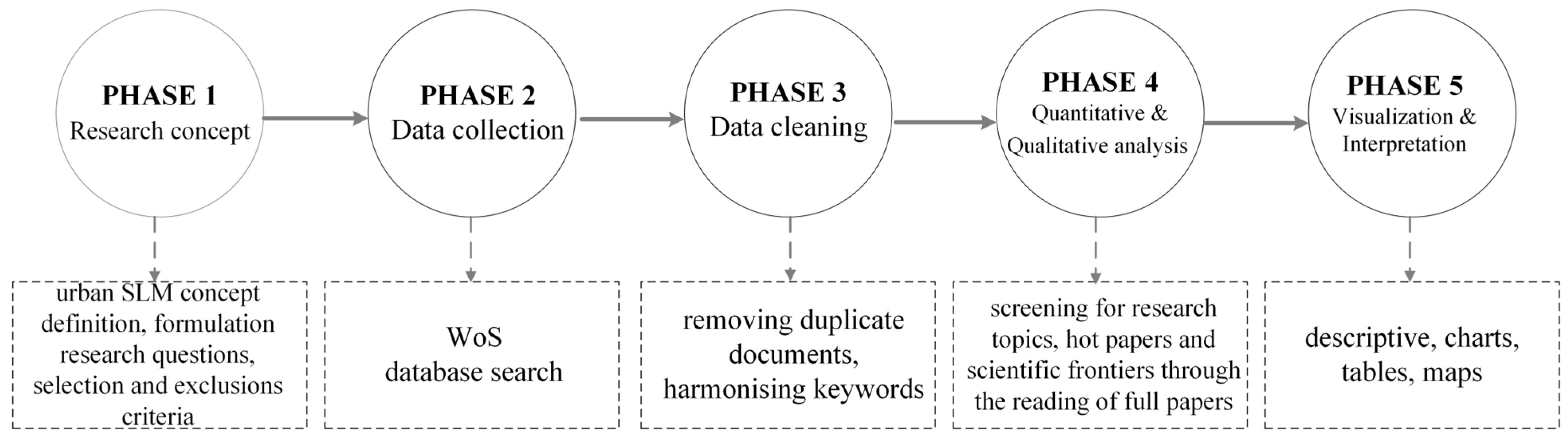
3. Methodological Approach

Scientific systematic literature reviews employ various methods to address both emerging and established issues, each offering distinct insights into knowledge generation, text development, and individualization [22,23,24,25]. As an emerging research topic, sustainable urban land management greatly benefits from a literature synthesis, given the ongoing debate among academics, practitioners, authorities, and policymakers regarding which indices and data should be considered in the pursuit of sustainable urban development. To this end, this research focuses on a systematic literature review carried out on the guidelines provided in the Preferred Reporting Items for Systematic Reviews and Meta-Analyses (PRISMA). PRISMA enables researchers to systematically synthesize existing evidence on a specific research question using transparent, reproducible methods. In this study, the systematic analysis focuses on research documents indexed in the Web of Science (WoS) Journal Citation Reports, dealing specifically with the intersection of sustainable urban land management (SULM) and earth observation (EO). The goal is to answer the following research questions:
Q1:
Are the main intellectual foundations of EO-based SULM rooted in interdisciplinary approaches?
Q2:
Is research on SULM using earth observation data unevenly distributed across regions and environmental challenges?
Q3:
What emerging technologies have supported recent advancements in EO-based SULM research?
As illustrated in Figure 1, the methodological approach follows five main phases that correspond to the PRISMA 2020 statement [23]. The first phase, research conceptualization, relies on defining the concept of urban SULM, formulating research questions, and establishing inclusion and exclusion criteria. This phase is extremely important because it defines the purpose and scope of the systematic review. Next, after defining principal keywords, a WoS database search is conducted for a comprehensive search for the relevant literature. The third phase, data cleaning, aims to remove duplicates, harmonize keywords, and standardize country names using a thesaurus file. Quantitative and qualitative analysis—the fourth phase—screens articles for key research topics, identifying “hot papers” and scientific frontiers through in-depth reading. Finally, visualization and interpretation present the findings using descriptive statistics, charts, tables, and maps.
The research document relevant for the analyzed topic was performed by applying the composed question as follows: TS = (“remote sens*” OR “satellite data*” OR “remote measurem*” OR “Remote measur*” OR “satellite-based track*” OR “satellite-monitor*” OR “satellite monitor*” OR “Landsat*” OR “MODIS*” OR “Sentinel*” OR “Copernicus*” OR “EO” OR “Earth Observa-tion*”) AND TS=(“Sustainable Land Management*” OR “SDG*” OR “Sustainable Devel-opment*” OR “Sustainable Development Goal*” OR “Sustainable Land Monitor*” OR “SLM” OR “Agenda 2030*”) AND TS=(“urban*”).
The exclusion criteria comprised the following:
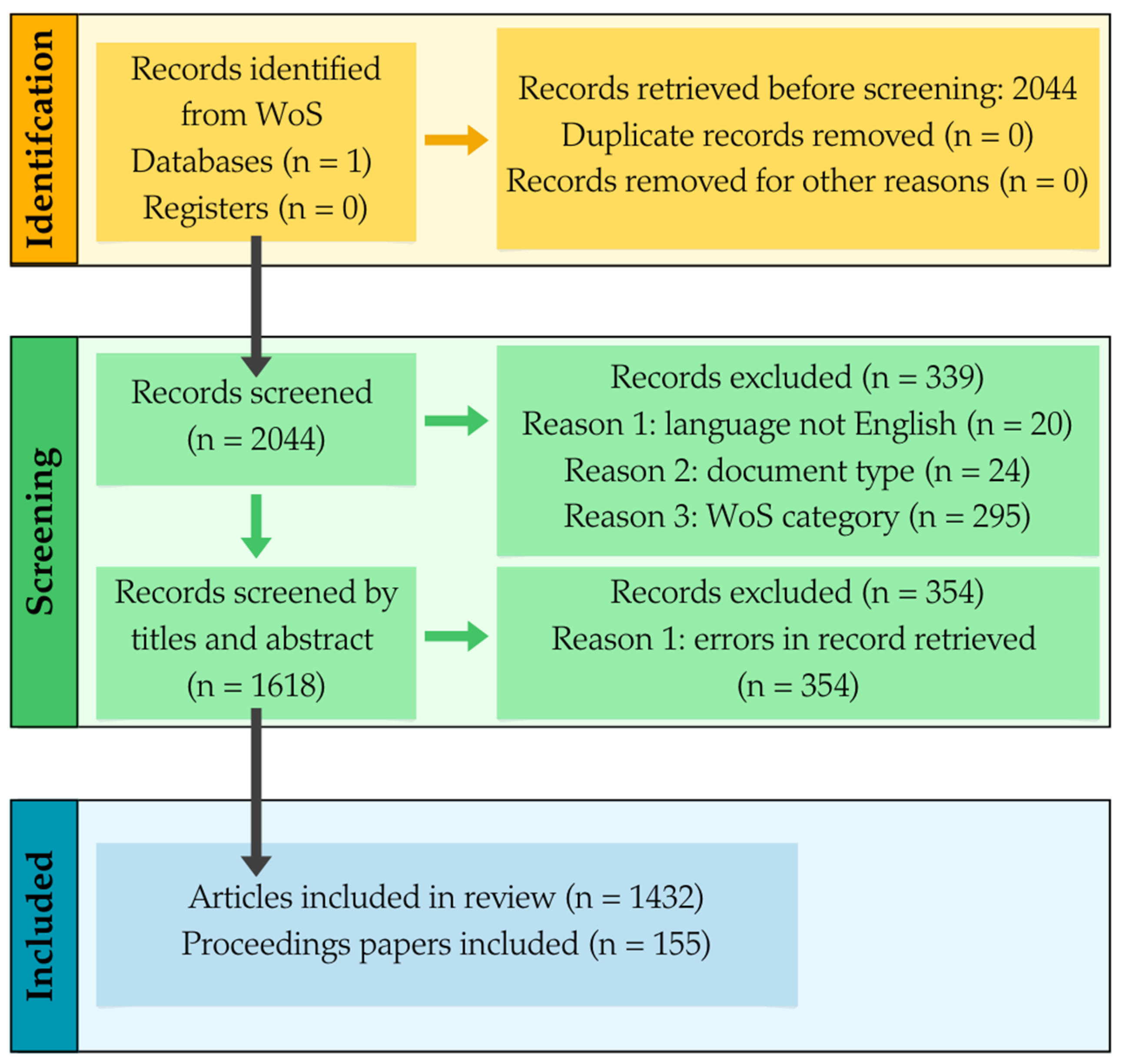
  • WoS categories not related to environmental sciences (e.g., medicine, engineering, electronics, information technology).
  • Publication year: 2025.
  • Document types: editorial material, retracted publication, or book chapter.
Finally, 1618 documents were selected for systematic analysis on 18 January 2025. The summary flow diagram, following the PRISMA 2020 recommendation, included searches in the databases shown in Figure 2.
Citation analysis revealed the dynamics of research in sustainable urban development, including the number of publications and citations per year, the most productive authors and journals, and descriptive statistics (e.g., standard deviation (STD), variance-to-mean ratio (VMR), and R-squared). The Gini index was used to illustrate inequality in the number of publications across journals. Co-occurrence network links (L) and total link strength (TLS) were used to assess the collaboration among authors, organizations, and countries. To identify the intellectual foundations, research problems, and key challenges, citation, co-citation, and bibliographic coupling were employed—using indicators such as links (L), total link strength (TLS), and the number of publications and citations. The analysis of the co-occurrence of key terms in titles and abstracts and the analysis of networks of authors, organizations, and countries was carried out using VOSviewer [26]. The “association strength” or the “LinLog/modularity” method was chosen for normalizing the strength of the links between items [27].

4. Results

4.1. Bibliometric Overview of Scientific Productivity

4.1.1. Publication and Citation Diachronic View

A total of 1618 research publications on sustainable urban land management using earth observation data were produced over the past three decades (1995–31 December 2024). These comprise mainly journal articles (1432), proceedings papers (155), and review papers (35). A clear exponential growth trend is observed, with notable spikes in 2015 and 2021 (Figure 3).
Until 2015, only a few research papers were published annually. The first significant increase in publications was linked to the launch of the Copernicus program and the deployment of the Sentinel satellite family: Sentinel-1 (2014, 2016), Sentinel-2 (2015, 2017), Sentinel-3 (2016, 2018), and Sentinel-5P (2017). A key milestone in the development of satellite data used in urban sustainability analysis was the activation of Landsat 9 in 2021. Its high spectral resolution provides valuable information about the earth’s surface and its various features, such as monitoring changes in surface temperature, including the urban heat island effect. This enhanced capability led to a 1.5-fold increase in the number of publications on the topic. A notable trend is the significant rise in research during the 21st century, particularly after 2015, following the publication of Agenda 2030 and the associated Sustainable Development Goals. An analysis of journals, publication titles, and assigned research fields revealed a wide variety, with a clear dominance of environmental sciences and ecology (63% of the papers analyzed). Remote sensing ranked second with half as many articles (540 articles or 32%), followed by geology (20%). Other scientific fields represented include technical sciences, public administration, agriculture, and forestry—amounting to a total of 24 fields with at least 15 publications, each of the 1618 publications was cited 28,671 times. The average number of citations per publication is, therefore, 17.72, with the annual number of citations ranging from 0 to 8307. The diversity of the number of citations between 1995 and 2024 was also confirmed by the high coefficient of variation (VMR = 208.9) and standard deviation (STD = 2139.6).

4.1.2. Journals and Conferences

Remote Sensing is the most frequently selected journal for publishing articles on EO data applied in the analysis of urban SLM assessments. It published 10.4% (169 papers) of all papers analyzed. Other leading journals include Sustainability (155; 9.6%), Land (70; 4.3%), Ecological Indicators (53; 3.3%), and the IEEE Journal of Selected Topics in Applied Earth Observations and Remote Sensing (JSTARS) (32; 2%). Among the publishers, MDPI leads with 488 publications (30.2%), followed by Elsevier (381; 23.6%), Springer Nature (207; 12.8%), IEEE (94; 5.8%), and Taylor & Francis (76; 4.7%). The Web of Science impact factor (IF) varies most among these journals. The highest IF is for the International Journal of Applied Earth Observation and Geoinformation (IF = 7.5). The lowest, 0.99, is that of Environmental Science and Pollution Research, but in the environmental science category, WoS ranks in the first quartile, 86th place out of 359. In all the journals listed in Table 1, authors from China dominate, accounting for an average of 57.1% of authors published in urban SLM by remote sensing data topic, reaching as high as 93.9% in IEEE Journal of Selected Topics in Applied Earth Observations and Remote Sensing, the highest value.
The journal publication inequalities described above, as illustrated by the Gini coefficient, are shown in Figure 4.
The top ten journals published 621 research papers (including articles, reviews, and conference proceedings), which were cited a total of 25 times (ranging from 3249 in Remote Sensing to 534 in Remote Sensing Applications: Society and Environment). These 621 papers had a significant impact on other research studies. The papers published in the top journals referenced the common previously printed works, i.e., they were bibliographically linked. Figure 5 shows the journals whose papers focused on remote sensing technology and methodology (the green cluster) and sustainability (the red cluster) of ecosystems and land management.
Conference papers demonstrating the synergy between urban SLM and earth observation data were most frequently presented in the proceedings of international conferences such as the IEEE International Geoscience and Remote Sensing Symposium (IGARSS), the International Conference on Geoinformatics, and the Joint Urban Remote Sensing Event.

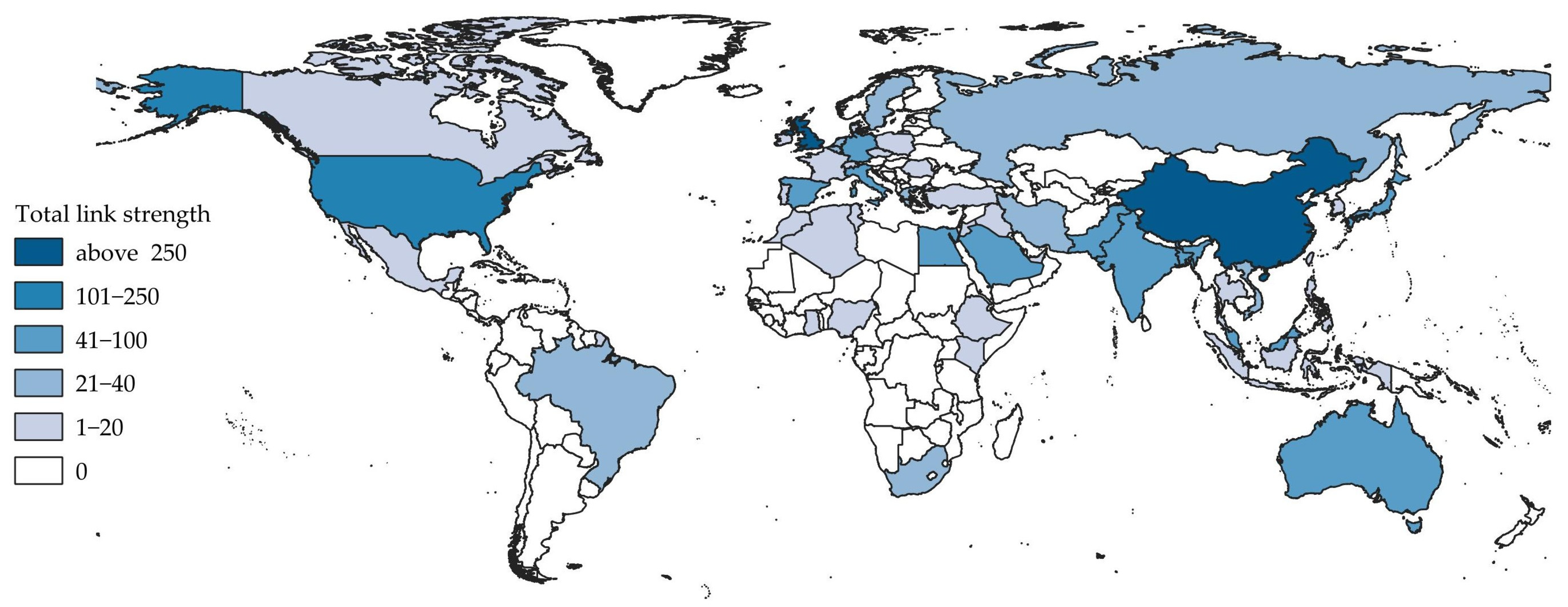
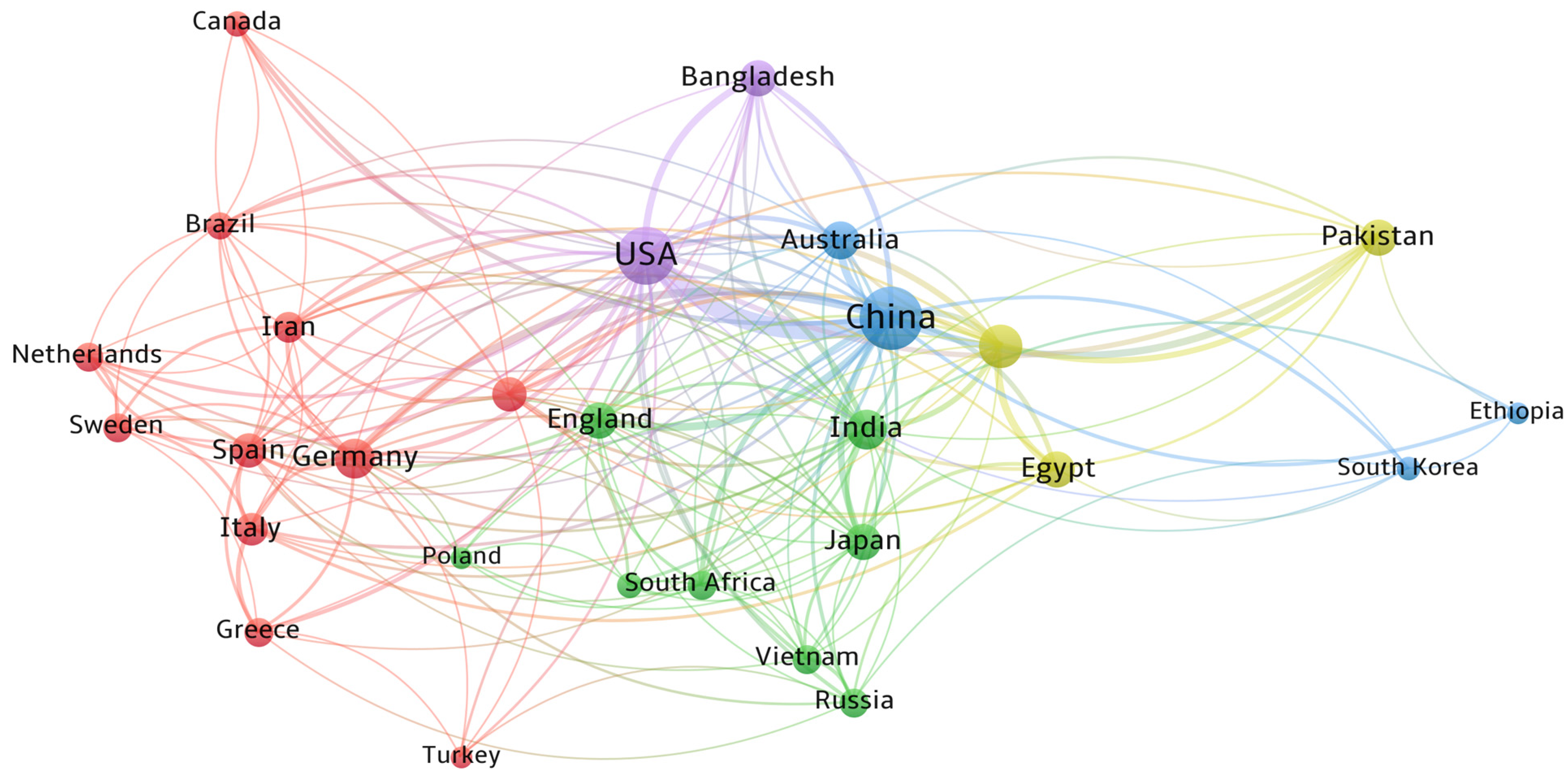
4.2. Cooperation Between Parties Involved in Urban SLM

Of the 6282 authors analyzed, only 5 had published at least ten papers (Table 2). Some of these authors collaborated on joint publications, while others published independently. The scientific work of prominent authors spanned environmental topics (e.g., land use/land cover classification, land use change, urban heat islands, and air pollution), socio-economic issues (e.g., informal settlements, health risks, and urbanization), and remote sensing indices and technological advancements (e.g., image classification, sensors, geospatial technologies, and big data processing).
International collaboration among authors studying urban SLM using EO data is significant. Ten of the analyzed publications were co-authored by researchers from different countries and five involved collaborations across several countries. China and the USA dominate the international collaborations, with the highest number of co-authoring researchers. The total link strength among collaborating authors is illustrated in Figure 6, which presents cooperation at the country level. Both countries contributed to more than 200 publications.
The collaborative productivity network of countries (Figure 7) shows that Asian countries have a high number of collaboratively published articles (highlighted in green). European countries also feature as frequent collaborators (red cluster).
China and the United States, the two countries with the highest publication counts, engaged extensively in international co-authorship across the globe. The blue and purple clusters represent countries from various continents with significantly fewer publications. Authors from China published 896 papers through international cooperation, followed by the USA (200) and India (164), cited 16,198, 6172, and 2164 times, respectively. Germany ranked fourth, after China, the USA, and India, with 72 publications cited 2058 times. Italy followed with 54 papers (1201 citations), and the United Kingdom with 51 papers and 1026 citations. The United States and European countries were the first to initiate collaborative research on sustainable urban land management using remotely sensed data, with other countries, primarily in Asia, joining later.

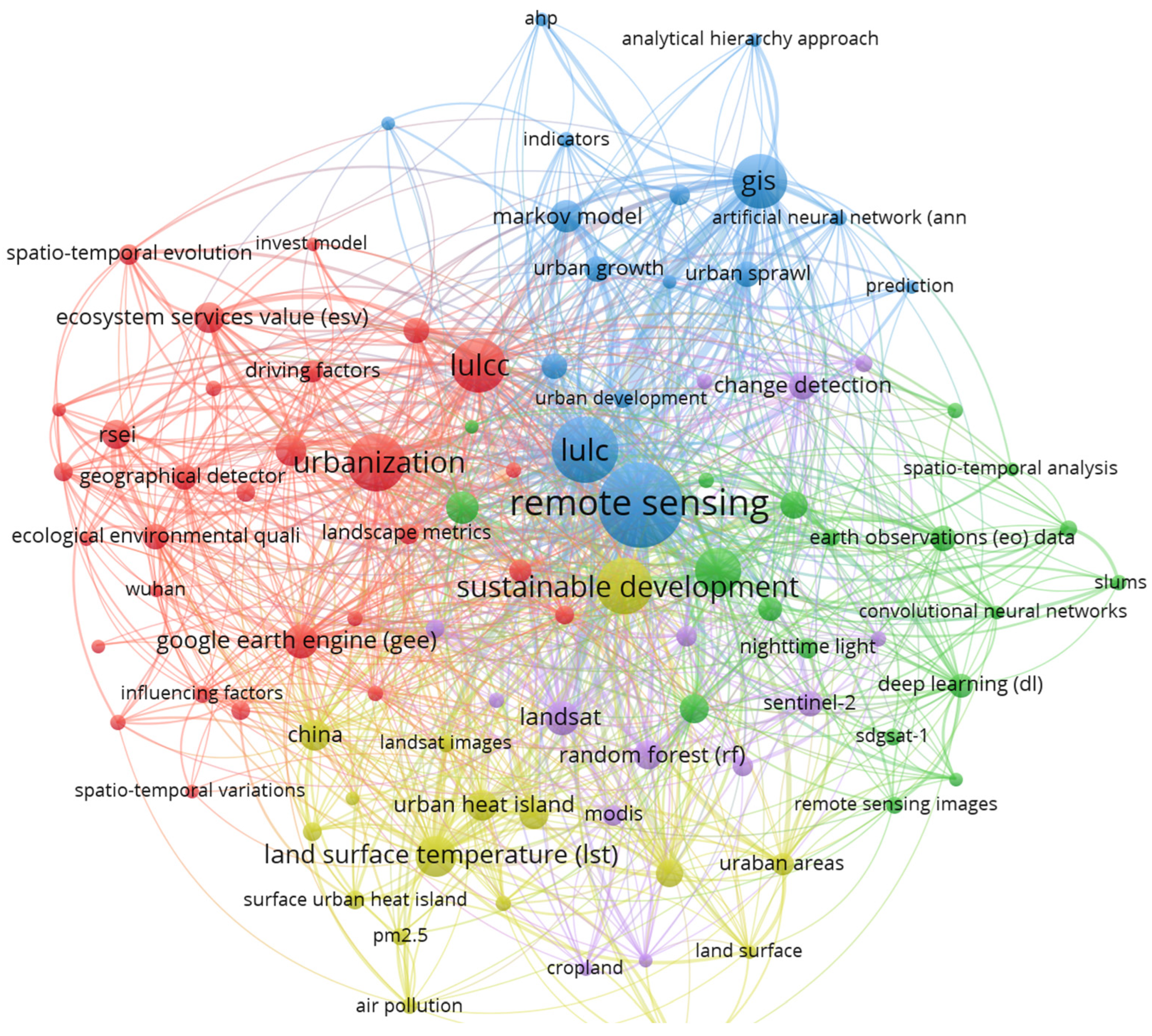
4.3. Keywords Exploration

Of the 1540 words that authors identified as best indicating the content of the papers, known as authors’ keywords, 94 were repeated in at least ten publications. These keywords were grouped into five clusters using the association strength method and are presented in Figure 8. Larger circles represent more frequent keyword use; thicker lines indicate stronger associations between keywords. Colors represent general thematic groupings discussed in the publications. The red cluster, the largest (comprising 29 terms), focuses on research related to urbanization and land use/land cover change within the context of eco-environment, ecosystems, monitoring, and quality assessment. Keywords point to problems to be addressed (e.g., imperviousness, urbanization, and spatio-temporal evolution), technological tools (e.g., Google Earth Engine, GIS, and the InVest model), and methodological aspects such as landscape indices, land surface temperature (LST), principal component, the remote sensing ecological index (RSEI), and coupling degree. In summary, the red cluster includes studies exploring the dynamic interaction between innovation and eco-efficiency. This body of research highlights how technological advancements can be leveraged to monitor and mitigate the environmental impacts of urban growth, offering tools for more informed land management strategies.
The green cluster (19 terms) concentrates on the Sustainable Development Goals (SDGs) outlined in Agenda 2030. Among the 17 SDGs, Goal 11 on sustainable cities and communities is the most prominent. Slums, informal settlements, urban sprawl, urban land use, and urban planning represent pressing challenges to be addressed, primarily through the use of nighttime satellite imagery and the second Sustainable Development Goals Satellite (SDGSAT-1). The methodologies employed include deep learning and artificial intelligence. This cluster highlights the growing role of satellite-based urban analysis in addressing social equity and spatial justice in rapidly urbanizing environments.
Urban growth modeling research is represented in the blue cluster, which comprises 16 keywords. These studies primarily address changes and employ various decision support techniques, such as the Analytical Hierarchy Process (AHP), Markov chains, cellular automata, and artificial neural networks. The yellow cluster, also comprising 16 keywords, focuses on spatio-temporal patterns of climate, air pollution (PM2.5—fine particulate matter), and urban heat islands. The fifth cluster, shown in purple (Figure 8), contains keywords related to satellite imagery (Landsat, MODIS, Sentinel-2) and data processing classifiers such as random forest, support vector machines (SVMs), and supervised classification. Table 3 lists the ten most frequently used author keywords.
It is noteworthy that there are other words outside the top ten that are important when examining research issues such as urban expansion (53 occurrences, 104 total link strength), urban heat island, SDG11, climate change, or ecosystem services value (see Table 4).

4.4. Main Research Topics and Trends

An analysis of the 50 most relevant and highly cited publications revealed two primary research streams, socio-environmental and technological–methodological.
The socio-environmental stream focuses on the exploration, assessment, and monitoring of ecosystem services, urban heat islands, and land use transformation as key drivers of climate change. These changes have significant environmental impacts, influencing urbanization, human health, and informal settlements. According to Schwilch et al. [28], effective monitoring and assessment of SULM requires a multi-scale approach that incorporates local knowledge with scientific data, ensuring a comprehensive evaluation of land use and environmental degradation.
The technological–methodological stream highlights the role of remote sensing and geoinformation technologies, emphasizing their fusion to develop more tailored models and indicators. Researchers, such as Hurni [29], also stress that methodological approaches must be adapted to the study and local conditions in order to enhance sustainability. Table 4 summarizes the key research topics, methods, and satellite data used; a detailed description is provided below.
Table 4. Emerging research topics, methods, and RS satellites.
TopicMethodsSatellites and ImageriesPublications 1
Ecosystem and ecosystem servicesCoupling and coordination, RSEI correlation Landsat, China’s HJ-1A/B, Tiangong-2 WIS Ariken et al. [30], Szumacher and Pabjanek [31], Shao et al. [32], Xu et al. [33]
Heat island and land surface temperature (LST)Spatial regression, spatial autocorrelation, cellular automata (CA), artificial neural network (ANN), landscape metricsLandsat, MODIS, Sentinel-2/3Zhou et al. [34],
Yin et al. [35], Kafy et al.
[36], Dugord et al. [37], Ravanelli et al. [38]
Informal settlements/slumsOBIA, random forest classifier, deep learning (Deeplab V3 Plus model, Xception network), semantic segmentationVHR, SPOT-6, Sentinel-2, Street View ImagesPatino and Duque [39], Chulafak et al. [40], Zhang et al. [41], Stark et al. [42]
Land use/land cover changes and urbanization and urban sprawlCoupling and coordination, supervised classification, machine learning (ML) algorithms, indexes (Standardized Precipitation Index (SPI) Standardized Water Level Index (SWI), urban land use change models, Markov chains–cellular automata (MC-CA)Multitemporal Landsat images, Sentinel-2A, ICONOS, MODIS, China’s HJ-1A/BShao et al. [32], Xu et al. [33], Yu et al. [43], Kumar et al. [44], Zhu et al. [45]
1 Selected publications.

4.4.1. Socio-Environmental Problems

The socio-environmental stream focuses on assessing ecosystem services, urban heat islands, and land use transformation as critical drivers of climate change with significant consequences for urbanization, human health, and informal settlements. Effective monitoring and assessment of SULM require a multi-scale approach. Studies on the analysis, assessment, monitoring, and prediction of urban expansion mainly have been prominent since the early 21st century. Key topics include urban form analysis [46], urban land use, and urban growth modeling based on Landsat, CARTOSAT-1 images, and GISs [43,44,47]. In the second decade, research on ecosystem services (ESs) and ecosystem service value (ESV) emerged [48]. Szumacher and Pabjanek [31] highlight the importance of ecosystem services in urban and suburban areas for maintaining quality of life. Their study of 85 European cities found improved access to recreational areas, benefiting public health, but also noted a decline in food supply services due to increased impervious surfaces and soil contamination. It is worth noting that the research documents analyzed did not present concrete policies but rather proposed various actions to counteract unsustainable urban development. For example, based on land use changes in Daqing City, China, Yu et al. [43] recommended a strategy focused on the protection of grassland and wetland landscapes. Cao et al. [48] suggested that China’s population migration policy should be relaxed and that the expansion of urban land development should prioritize areas with low-cost ecosystem service values. Similarly, Estoque and Murayama [49] argued that Baguio City in the Philippines must strike a balance between socio-economic development and environmental protection. They underlined that the planning system should place greater focus on preserving landscapes and ecosystem services.
The remote sensing ecological index (RSEI) has become a widely used tool for assessing eco-environmental quality, particularly due to its efficiency across large areas. Researchers value the index for its efficiency, especially in large-scale applications. Based on the potential of the RSEI, Ariken et al. [30] used the RSEI, derived from Landsat and Tiangong-2 WIS data, to examine the relationship between urbanization and ecological health in arid regions of China.
The rise of social media in scientific research has led to new studies on urban sprawl and sustainable urban development. Shao et al. [32] fused Landsat imagery with Twitter data to assess urban sprawl in Morogoro, Tanzania. Cao et al. [48] utilized Landsat imagery and China’s HJ-1A/B environmental hazards monitoring satellite to explore urbanization in China, focusing on the relationship between regional urban forms, economic growth, and ecosystem service costs. Similarly, Xu et al. [33] investigated the relationship between eco-environmental quality (EEQ) and urban sprawl in Chinese metropolises, identifying a limited understanding of the feedback mechanisms between urbanization and ecological quality. Despite the growing body of research, Cao et al. [48] highlighted the ongoing lack of understanding regarding feedback mechanisms between urbanization and ecological environmental quality.
Informal settlements (or slums) continue to pose a global challenge. According to UN-Habitat’s 2004 report The Challenge of Slums, 924 million people lived in slums at the beginning of the 21st century, representing 32% of the global urban population and up to over 43% in developing regions [50]. Recent advancements in remote sensing, particularly very-high-resolution (VHR) data and object-based image analysis (OBIA), have enabled more detailed studies of slum geography and dynamics. Patino and Duque [39] highlight the role of earth observation data in urban research along with the emergence of a wide range of concepts, algorithms, and applications. Kuffer et al. [51] noted that slum identification studies are driven by the persistence and growth of this kind of informal settlement and the emergence of new ones, especially in countries of the Global South. Hofmann et al. [52] highlighted the complexity involved in defining and mapping informal settlements. The absence of a clear definition and theoretical framework complicates the process, while visual similarities between informal and formal settlements further contribute to the challenge. Understanding the unique historical and contextual background of each settlement is crucial for accurate identification and mapping. Taubenböck and Kraff [53] demonstrated that the morphological and structural characteristics of informal settlements can differ significantly from those of surrounding formal urban areas. Object-based algorithms, active contour models (“snakes”), radial casting algorithms, and visual classification methods have been employed to exploit morphological differences in slum appearances using remote sensing data. Other authors used direct spatial features derived from individual buildings, such as size, shape, or height, along with their density and orientation [54,55].
Heating represents an environmental threat in many cities, regardless of their geographic location or spatial extent, as reflected in recent studies. The urban heat island (UHI) effect is an increasing concern due to accelerated urbanization [34,56]. Since 1972, there has been exponential growth in publications on surface urban heat islands (SUHIs), as noted by Zhou et al. [34]. They revealed that China and summer daytime periods are the most frequently studied contexts in SUHI research. Most of the research, around two-thirds, focuses on local-scale urban heat variability, with Landsat and MODIS being the most commonly used satellite sensors. Surface urban heat islands vary across spatial scales (local to global) and temporal dimensions (inter-annual, seasonal, diurnal). Key influencing factors include impervious surfaces, vegetation, landscape patterns, and climate. Yin et al. [35] pointed out that building density and urban form are key indicators affecting UHI assessment and interpretation and that spatial regression is a promising method. In contrast, Kafy et al. [36] argue that a reduction in vegetation cover significantly amplifies the impact of UHIs in cities. A similar view was shared by Chen et al. [57]. Dugord et al. [37] found that landscape metrics, such as area, edge, shape, and aggregated land use metrics, are highly promising indicators of SUHIs. The authors confirm that impervious surfaces, summertime conditions, and proximity to the city center are key drivers of UHIs. Research by Cilek and Cilek [58] also highlighted that building density and height, surface reflectance (albedo), vegetation type and fragmentation, and water bodies all influence LST values. Zhou et al. [34] warned that research on SUHIs faces several limitations in both data and methodology. The quality of LST data and understanding of the area of interest required improvement. Furthermore, the measurement of SUHIs intensity, interannual trends, scaling issues, surface–subsurface UHI relationships, and the integration of remote sensing with field observations and modeling still require in-depth investigation. Additional challenges include the analysis of LST–air temperature differences, cloud interference, resolution trade-offs, and limited data availability. The authors recommend the use of long-term archives and time series analysis to enhance data reliability. Zhou et al. [34], based on a thorough analysis of the literature on surface urban heat islands, highlighted the challenges associated with implementing effective mitigation and adaptation strategies. Some of the strategies discussed include urban greening and nature-based solutions (e.g., green roofs), the creation of wind corridors, community engagement in urban planning (i.e., participatory planning), and the use of renewable energy to reduce energy consumption related to the urban heat island effect. However, the analyzed research document does not provide specific real-world examples of these strategies in practice.
Sustainable land management (SLM) is essential for achieving the goals of various environmental resolutions and international conventions, including the UN 2030 Agenda for Sustainable Development [5]. Among the 17 Sustainable Development Goals of the 2030 Agenda, Goal 11—aiming to “make cities and human settlements inclusive, safe, resilient, and sustainable”—is particularly significant for monitoring SLM in urban areas. Li et al. [59] stated that over the past decade, the number of studies evaluating urban SDGs has increased significantly, including both single- and multi-goal assessments using remote sensing and big data. SDG indicator 11.3.1, which measures the land consumption rate (LCR) relative to the population growth rate (PGR), exemplifies the integration of RS and GISs across various scales, including global [60], continental [61], regional [62], and local [63] studies. Additionally, the proportion of slums and informal settlements within the total population, as measured by SDG indicator 11.1.1, is crucial for assessing urban sustainability [64].

4.4.2. Geoinformation Technologies and Methodology

Understanding cities requires continuous monitoring of urban transformations and their interactions with surrounding environments. Remote sensing provides consistent, global data to address these knowledge gaps. With the increasing availability of sensors, drones, and smart devices, urban sensing and modeling have become significantly more advanced. Since the launch of ERTS-1 and subsequent Landsat missions, remote sensing data have played an instrumental role in sustainable urban land management. By December 2024, over 505 scientific papers indexed in WoS had investigated this issue [52,65] and forecast urban growth [66]. Patino and Duque [39] emphasized that thanks to cost reductions, the availability of earth observation data has increased significantly in the 21st century.
The unique characteristics of EO data, including cyclicity, broad area coverage, and the ability to record the earth’s surface across various spectral bands, facilitate the exploration and testing of hypotheses and models related to urban areas and the development of new theories to analyze and solve urbanization problems [67]. Moreover, the growing spatial resolution of satellite imagery is crucial for studying urban settlements, as it now enables the identification of individual objects such as building types, street details, trees, and open spaces. Remote sensing imagery includes medium-resolution (e.g., Landsat MSS, TM, ETM+, ASTER, IRS), high-resolution (e.g., SPOT, Sentinel), and very-high-resolution images such as WorldView-3, QuickBird, and IKONOS panchromatic [55].
Artificial intelligence (AI)-based applications are helpful in image analysis and for linking heterogeneous datasets [65,68]. However, researchers claim that current algorithms often fail to produce outputs that are accessible, robust, and reliable enough to support urban decision making. To address these challenges, Wang et al. [65] suggested combining geographic principles with a unified framework for remote sensing imagery interpretation. This involves trustworthy interpretation (TRSI) that considers space, time, and attributes to understand complex geographical areas. Wang et al. [65] tested technologies at multiple scales, including pixel-level visual perception, geo-parcel-level quantitative analysis, and scene-level geographic interpretation. A big data interpretation system with semantic parsing supports precise applications through cloud-edge collaboration. However, supervised image classification continues to face challenges regarding the reliability of training data. Manual interpretation introduces subjectivity, which negatively affects classification accuracy [68,69].
Over the past two decades, geospatial technologies have transformed land, environmental, and urban research. With the increasing integration of artificial intelligence, these technologies continue to evolve rapidly.

5. Discussion

Sustainable urban land management requires the integration of knowledge, data, technology, diagnostics, recommendations, policy, and monitoring—as highlighted by the philosophy of eco-development [70,71] and supported by numerous academic sources [39,52,53,72]. The components of sustainable land management (SLM) (Figure 9) can be summarized by the Latin phrase six iuncta in uno (six joined in one).
The analyzed studies identified the key principles, strategies, and recommendations for efficient urban sustainable land management using earth observation data. Land use/land cover changes and vegetation—expressed through various satellite-based vegetation indices—are widely employed as proxies in urban SLM and the pursuit of sustainable development. Several authors including Avtar et al. [73], Kumar et al. [44], Bielecka and Jenerowicz [70], and Heregeweyn et al. [74] argued that urban heat islands, biodiversity loss and fragmentation, land degradation, and the weakening of ecosystem services require continuous monitoring and assessment. Our findings support these conclusions.
Kumar et al. [44] classified sustainable development as a foundational theme characterized by high visibility but low impact, whereas quality of life was identified as a motor theme, exhibiting both high impact and high visibility.
They further observed that sustainability research in China is highly developed, leaving limited scope for further exploration. Similarly, Haregeweyn et al. [74] and Patino and Duque [39] noted a strong dominance of publications on this topic. Our study corroborates these observations, highlighting the substantial contribution of Chinese authors (see Table 2 and Figure 6 and Figure 7). Additionally, Haregeweyn et al. [74] noted that sustainable land management initiatives are unevenly distributed across geographical regions, with relatively low adoption in underdeveloped countries characterized by low Human Development Index (HDI) scores, such as those in sub-Saharan Africa. This underrepresentation is also clearly evident in our scientific review. Numerous scholars [25,44,49,73,74] emphasized that advances in remote sensing satellites and sensors—particularly micro-satellites and unmanned aerial systems (UASs)—are creating new opportunities to integrate remotely sensed data into urban SLM research at decision-relevant scales. These technological advancements are accelerating progress in urban SLM research. Emerging or underutilized methodologies—including thermal sensing, citizen science, cloud computing, mobile mapping, and the concept of “humans as sensors”—will continue to enhance SLM research, support sustainable development goals, and advance environmental science.
Notably, the analysis of 1618 research papers revealed diverse approaches to the use of remote sensing data and technologies, indicator selection, and recommendations. The differences are primarily related to available resources and the year of the study. Moreover, the geographical diversity of the analyzed area is also clearly visible. The dominance of Chinese scientific papers undoubtedly influences global perspectives on SULM by accentuating issues, solutions, and approaches that are context specific to China’s rapid urbanization, environmental hazards (e.g., desertification), and policy priorities. Public data sources that are difficult for other researchers to access (statistical databases, geographic databases, and satellite imagery) are also important. While this contributes valuable insights, it may inadvertently underrepresent challenges and strategies relevant to other regions, especially in low-income or less urbanized countries, potentially skewing the global research agenda and policy discourse. Balanced contributions from diverse geographical contexts are essential to ensure globally inclusive and applicable understandings of sustainable urban land management.
It is not only modern technology (e.g., mobile sensors and drone technologies) that deserves to be highlighted but also the increasing amount of crowdsourced data. Crowdsourced data, such as reports from citizens via mobile applications or platforms like OpenStreetMap, can capture localized land use changes, urban expansion, and environmental concerns that may be missed by satellites. Mobile sensors, often embedded in smartphones or vehicles, collect real-time data on air quality, temperature, noise, and mobility patterns, enriching EO datasets with ground-level insights. Drones offer flexible, high-resolution aerial imagery, enabling detailed assessment of urban infrastructure, vegetation cover, and land use at the neighborhood scale. Together, these technologies bridge data gaps, support participatory urban planning, and enable responsive, evidence-based decision making in urban SLM.
A key limitation of this study lies in the semantic ambiguity and the absence of universally accepted definitions. The term “urban area” is variously defined—ranging from human settlements to cities—with considerable variation across studies. Similarly, the definition of “forest” requires harmonization. Future research should prioritize the indices used in SLM monitoring, with particular emphasis on advancing remote sensing science, data sources, and analytical methodologies.

6. Conclusions

This bibliometric study provides valuable insights into the changing landscape of sustainable urban land management (SULM), particularly in the context of increasing global efforts to adopt sustainable development practices. Sustainable development is widely regarded as the only viable foundation for the continued survival of humanity on earth, and SULM offers strategic directions for development and responses to emerging crises. However, although sustainability is well established in both theory and legislation, its practical implementation remains challenging. Further difficulties arise, and additional challenges stem from the evolving nature of the concept of sustainable development itself. Scholars continue to debate whether sustainable development represents a singular, continuously evolving idea originating in the late 1960s or a pluralistic framework composed of multiple, often context-specific interpretations. Most researchers adopt the definition proposed by the United Nations and its agencies, particularly UNEP, and further developed by the Brundtland Commission and subsequent Earth Summits.
The analysis revealed six core areas of analytical significance.
  • Geographical context. Understanding the physical, economic, and social characteristics of urban areas is essential for meaningful interpretation and for informing context-specific policy decisions.
  • Remote sensing data. EO data, particularly when supplemented with vector datasets and crowdsourced or social media inputs, play a dominant role in urban SULM analysis and monitoring.
  • Artificial intelligence. ML techniques and neural networks are now at the forefront of analytical methods, driving advances in data interpretation and urban diagnostics.
  • Journals. The most impactful publications in the field appear in Remote Sensing, Sustainability, and Land published by MDPI (Switzerland).
  • Countries. China and the United States lead in publication output and citation impact, highlighting their central role in shaping global research directions.
  • Research trends in urban SLM can be categorized into two main principal streams: socio-environmental and technological–methodological. Key challenges in urban land management include land use transformation, urban heating, vegetation and landscape modification, pollution, and climate change.
This study underscores the need for sustained interdisciplinary collaboration and technological innovation to address the complexities of urban sustainability. The integration of crowdsourced data, mobile sensing technologies, and drone platforms significantly enhances satellite earth observation capabilities, offering high-resolution, real-time data to support more adaptive and inclusive urban land management strategies.

Author Contributions

Conceptualization, E.B. and A.M.; methodology, E.B., A.M. and B.W.; validation, A.M., E.B., B.W. and B.C.; formal analysis, A.M., E.B. and B.C.; data curation, A.M.; writing—original draft preparation, E.B., A.M. and B.W.; writing—review and editing, A.M., E.B., B.W. and B.C.; visualization, A.M., B.W. and B.C.; supervision, E.B. All authors have read and agreed to the published version of the manuscript.

Funding

This research has no additional funds.

Data Availability Statement

Data collected from WoS Core Collection are available via https://www.webofscience.com/wos/woscc/summary/cacb4a30-604e-4ad5-9370-e3d90f2ef7a8-0144c2897e/recently-added/1 (accessed on 18 January 2025).

Conflicts of Interest

The authors declare no conflicts of interest.

Abbreviations

The following abbreviations are used in this manuscript:
AIArtificial intelligence
CNNConvolutional neural network
EOEarth observation
ES, ESVEcosystem service, ecosystem services valuation
GISGeographic information system
OBIAObject base image analysis
PRISMAPreferred reporting items for systematic reviews and meta-analyses
RFRandom forest
RSRemote sensing
SDGsSustainable Development Goals
SLMSustainable land management
SVMSupport vector machine
SULMSustainable urban land management
UNUnited Nations
UNEPUnited Nations Environment Program
USMLUrban sustainable land management
WoSWeb of Science

References

  1. Malthus, T.R. An Essay on the Principle of Population; Cambridge University Press: London, UK, 1992; pp. 1–430. [Google Scholar]
  2. Sustainability for All. Do You Know When Sustainability First Appeared? Available online: https://www.activesustainability.com/sustainable-development/do-you-know-when-sustainability-first-appeared/ (accessed on 20 January 2025).
  3. Luther, L. The National Environmental Policy Act: Background and Implementation; Congressional Research Service: Washington, DC, USA, 2005; pp. 1–35. Available online: https://citeseerx.ist.psu.edu/document?repid=rep1&type=pdf&doi=50c2a5bac14ebe05774a9f2200d61f4e9fb308f3 (accessed on 20 January 2025).
  4. United Nations. Our Common Future. Report of the World Commission on Environment and Development; Oxford University Press: Oxford, UK, 1987. [Google Scholar]
  5. United Nations Resolution 70/1. Transforming Our World: The 2030 Agenda for Sustainable Development, Adopted by the General Assembly on 25 September 2015. Available online: https://docs.un.org/en/A/RES/70/1 (accessed on 7 February 2025).
  6. Cornforth, I.C. Selecting indicators for assessing sustainable land management. J. Environ. Manag. 1999, 56, 173–179. [Google Scholar] [CrossRef]
  7. Liu, X.; Huang, Y.; Xu, X.; Li, X.; Li, X.; Ciais, P.; Lin, P.; Gong, K.; Ziegler, A.D.; Chen, A.; et al. High-spatiotemporal-resolution mapping of global urban change from 1985 to 2015. Nat. Sustain. 2020, 3, 564–570. [Google Scholar] [CrossRef]
  8. Ren, Z.; Fu, Y.; Dong, Y.; Zhang, P.; He, X. Rapid urbanization and climate change significantly contribute to worsening urban human thermal comfort: A national 183-city, 26-year study in China. Urban Clim. 2022, 43, 101154. [Google Scholar] [CrossRef]
  9. Emmanuel, R.; Krüger, E. Urban heat island and its impact on climate change resilience in a shrinking city: The case of Glasgow, UK. Build. Environ. 2012, 53, 137–149. [Google Scholar] [CrossRef]
  10. Hull, Z. Filozoficzne i społeczne uwarunkowania zrównoważonego rozwoju. Probl. Ekorozwoju 2008, 3, 27–31. [Google Scholar]
  11. Flannery, B.J.; Loi, N.M.; Schutte, N.S. The effect of humanising nature. Int. J. Psychol. 2024, 59, 1217–1224. [Google Scholar] [CrossRef]
  12. Piątek, Z. Człowiek jako podmiot zrównoważonego rozwoju: Konsekwencje filozoficzno-społeczne. In Zrównoważony Rozwój. Od Utopii do Praw Człowieka; Papuziński, A., Ed.; Wydawnictwo Branta: Bydgoszcz, Poland, 2005; pp. 14–30. [Google Scholar]
  13. Rawls, J. Justice as Fairness: A Restatement; Harvard University Press: Cambridge, MA, USA, 2001; pp. 1–240. [Google Scholar] [CrossRef]
  14. Agenda 21. Available online: https://sdgs.un.org/publications/agenda21 (accessed on 23 January 2025).
  15. Rąb, Ł. Filozoficzne podłoże koncepcji zrównoważonego rozwoju. Etyka Biznesu I Zrównoważony Rozw. Interdyscyplinarne Stud. Teoretyczno-Empiryczne 2016, 4, 83–90. [Google Scholar]
  16. Gawor, L. Idea zrównoważonego rozwoju jako projekt nowej ogólnoludzkiej cywilizacji. Diametros 2006, 9, 84–104. [Google Scholar]
  17. Scheler, M. Resentyment a Moralność (Das Ressentiment im Aufbau der Moralen), 1st ed.; Spółdzielnia Wydawnicza Czytelnik: Warszawa, Poland, 1997. (In Polish) [Google Scholar]
  18. Arendt, H. Kondycja Ludzka; Aletheia: Warsaw, Poland, 2010; pp. 1–363. [Google Scholar]
  19. Leopold, A. A Sand County Almanac: And Sketches Here and There; Oxford University Press: New York, NY, USA, 1989; pp. 1–240. [Google Scholar]
  20. Schumacher, E.F. Small Is Beautiful: A Study of Economics as if People Mattered; Blond & Briggs: London, UK, 1973; pp. 1–223. [Google Scholar]
  21. Shiva, V. The Violence of the Green Revolution: Third World Agriculture, Ecology and Politics; Zed Books Ltd.: London, UK; New York, NY, USA, 1991; pp. 1–257. [Google Scholar]
  22. Pickering, C.; Grignon, J.; Steven, R.; Guitart, D.; Byrne, J. Publishing not perishing: How research students transition from novice to knowledgeable using systematic quantitative literature reviews. Stud. High. Educ. 2015, 40, 1756–1769. [Google Scholar] [CrossRef]
  23. PRISMA Statement. Available online: http://www.prisma-statement.org/ (accessed on 2 February 2025).
  24. Garfield, E. Citation Indexing: Its Theory and Application in Science, Technology, and Humanities, 1st ed.; Wiley: New York, NY, USA, 1979; pp. 1–274. [Google Scholar]
  25. Bielecka, E. GIS Spatial Analysis Modeling for Land Use Change. A Bibliometric Analysis of the Intellectual Base and Trends. Geosciences 2020, 10, 421. [Google Scholar] [CrossRef]
  26. Bar-Ilan, J. Citations to the “Introduction to informetrics” indexed by WOS, Scopus and Google Scholar. Scientometrics 2010, 82, 495–506. [Google Scholar] [CrossRef]
  27. Van Eck, N.J.; Waltman, L. How to normalize cooccurrence data? An analysis of some well-known similarity measures. J. Am. Soc. Inf. Sci. Technol. 2009, 60, 1635–1651. [Google Scholar] [CrossRef]
  28. Schwilch, G.; Bestelmeyer, B.; Bunning, S.; Critchley, W.; Herrick, J.; Kellner, K.; Liniger, H.P.; Nachtergaele, F.; Ritsema, C.J.; Schuster, B.; et al. Experiences in monitoring and assessment of sustainable land management. Land Degrad. Dev. 2011, 22, 214–225. [Google Scholar] [CrossRef]
  29. Hurni, H. Assessing sustainable land management (SLM). Agric. Ecosyst. Environ. 2000, 81, 83–92. [Google Scholar] [CrossRef]
  30. Ariken, M.; Zhang, F.; Liu, K.; Fang, C.; Kung, H.T. Coupling coordination analysis of urbanization and eco-environment in Yanqi Basin based on multi-source remote sensing data. Ecol. Indic. 2020, 114, 106331. [Google Scholar] [CrossRef]
  31. Szumacher, I.; Pabjanek, P. Temporal Changes in Ecosystem Services in European Cities in the Continental Biogeographical Region in the Period from 1990–2012. Sustainability 2017, 9, 665. [Google Scholar] [CrossRef]
  32. Shao, Z.; Sumari, N.S.; Portnov, A.; Ujoh, F.; Musakwa, W.; Mandela, P.J. Urban sprawl and its impact on sustainable urban development: A combination of remote sensing and social media data. Geo-Spat. Inf. Sci. 2020, 24, 241–255. [Google Scholar] [CrossRef]
  33. Xu, D.; Yang, F.; Yu, L.; Zhou, Y.; Li, H.; Ma, J.; Huang, J.; Wei, J.; Xu, Y.; Zhang, C.; et al. Quantization of the coupling mechanism between eco-environmental quality and urbanization from multisource remote sensing data. J. Clean. Prod. 2021, 321, 128948. [Google Scholar] [CrossRef]
  34. Zhou, D.; Xiao, J.; Bonafoni, S.; Berger, C.; Deilami, K.; Zhou, Y.; Frolking, S.; Yao, R.; Qiao, Z.; Sobrino, J.A. Satellite Remote Sensing of Surface Urban Heat Islands: Progress, Challenges, and Perspectives. Remote Sens. 2019, 11, 48. [Google Scholar] [CrossRef]
  35. Yin, C.; Yuan, M.; Lu, Y.; Huang, Y.; Liu, Y. Effects of urban form on the urban heat island effect based on spatial regression model. Sci. Total Environ. 2018, 634, 696–704. [Google Scholar] [CrossRef]
  36. Kafy, A.A.; Rahman, M.S.; Islam, M.; Al Rakib, A.; Islam, M.A.; Khan, M.H.H.; Sattar, G.S. Prediction of seasonal urban thermal field variance index using machine learning algorithms in Cumilla, Bangladesh. Sustain. Cities Soc. 2021, 64, 102542. [Google Scholar] [CrossRef]
  37. Dugord, P.A.; Lauf, S.; Schuster, C.; Kleinschmit, B. Land use patterns, temperature distribution, and potential heat stress risk–The case study Berlin, Germany. Comput. Environ. Urban Syst. 2014, 48, 86–98. [Google Scholar] [CrossRef]
  38. Ravanelli, R.; Nascetti, A.; Cirigliano, R.V.; Di Rico, C.; Leuzzi, G.; Monti, P.; Crespi, M. Monitoring the Impact of Land Cover Change on Surface Urban Heat Island through Google Earth Engine: Proposal of a Global Methodology, First Applications and Problems. Remote Sens. 2018, 10, 1488. [Google Scholar] [CrossRef]
  39. Patino, J.E.; Duque, J.C. A review of regional science applications of satellite remote sensing in urban settings. Comput. Environ. Urban Syst. 2013, 37, 1–17. [Google Scholar] [CrossRef]
  40. Chulafak, G.A.; Khomarudin, M.R.; Roswintiarti, O.; Mehmood, H.; Nugroho, G.; Nugroho, U.C.; Ardha, M.; Sukowati, K.A.D.; Putra, I.K.Y.D.; Permana, S.A.B.S. Machine Learning-Based Local Knowledge Approach to Mapping Urban Slums in Bandung City, Indonesia. Urban Sci. 2024, 8, 189. [Google Scholar] [CrossRef]
  41. Zhang, Y.; Lu, C.; Wang, J.; Du, F. A large-scale extraction framework for mapping urban in-formal settlements using remote sensing and semantic segmentation. Geocarto Int. 2024, 39, 2345135. [Google Scholar] [CrossRef]
  42. Stark, T.; Wurm, M.; Zhu, X.X.; Taubenböck, H. Satellite-based mapping of urban poverty with transfer-learned slum morphologies. IEEE J. Sel. Top. Appl. Earth Obs. Remote Sens. 2020, 13, 5251–5263. [Google Scholar] [CrossRef]
  43. Yu, W.; Zang, S.; Wu, C.; Liu, W.; Na, X. Analyzing and modeling land use land cover change (LUCC) in the Daqing City, China. Appl. Geogr. 2011, 31, 600–608. [Google Scholar] [CrossRef]
  44. Kumar, S.; Radhakrishnan, N.; Mathew, S. Land use change modelling using a Markov model and remote sensing. Geomat. Nat. Hazards Risk 2013, 5, 145–156. [Google Scholar] [CrossRef]
  45. Zhu, Z.; Zhou, Y.; Seto, K.C.; Stokes, E.C.; Deng, C.; Pickett, S.T.; Taubenböck, H. Understanding an urbanizing planet: Strategic directions for remote sensing. Remote Sens. Environ. 2019, 228, 164–182. [Google Scholar] [CrossRef]
  46. Yeh, A.G.-O.; Li, X. A Constrained CA Model for the Simulation and Planning of Sustainable Urban Forms by Using GIS. Environ. Plan. B Plan. Des. 2001, 28, 733–753. [Google Scholar] [CrossRef]
  47. Shafizadeh-Moghadam, H.; Helbich, M. Spatiotemporal urbanization processes in the megacity of Mumbai, India: A Markov chains-cellular automata urban growth model. Appl. Geogr. 2013, 40, 140–149. [Google Scholar] [CrossRef]
  48. Cao, Y.; Kong, L.; Zhang, L.; Ouyang, Z. The balance between economic development and ecosystem service value in the process of land urbanization: A case study of China’s land urbanization from 2000 to 2015. Land Use Policy 2021, 108, 105536. [Google Scholar] [CrossRef]
  49. Estoque, R.C.; Murayama, Y. Landscape pattern and ecosystem service value changes: Implications for environmental sustainability planning for the rapidly urbanizing summer capital of the Philippines. Landsc. Urban Plan. 2013, 116, 60–72. [Google Scholar] [CrossRef]
  50. United Nations Human Settlements Programme (UN-Habitat). The Challenge of Slums—Global Report on Human Settlements 2003. Available online: https://unhabitat.org/the-challenge-of-slums-global-report-on-human-settlements-2003 (accessed on 2 February 2025).
  51. Kuffer, M.; Pfeffer, K.; Sliuzas, R. Slums from Space—15 Years of Slum Mapping Using Remote Sensing. Remote Sens. 2016, 8, 455. [Google Scholar] [CrossRef]
  52. Hofmann, P.; Taubenböck, H.; Werthmann, C. Monitoring and modelling of informal settlements—A review on recent developments and challenges. In Proceedings of the IEEE Joint Urban Remote Sensing Event (JURSE), Lausanne, Switzerland, 30 March–1 April 2015; pp. 1–4. [Google Scholar] [CrossRef]
  53. Taubenböck, H.; Kraff, N. The physical face of slums: A structural comparison of slums in Mumbai, India, based on remotely sensed data. J. Hous. Built Environ. 2014, 29, 15–38. [Google Scholar] [CrossRef]
  54. Kemper, T.; Pesaresi, M. Searching for Robust and Objective EO-Based Indicators for Slum Characterization; UN-Habitat, CIESIN, ITC: Enshede, The Netherlands, 2008. [Google Scholar]
  55. Wurm, M.; Stark, T.; Xiang Zhu, X.; Weigand, M.; Taubenböck, H. Semantic segmentation of slums in satellite images using transfer learning on fully convolutional neural networks. ISPRS J. Photogramm. Remote Sens. 2019, 150, 59–69. [Google Scholar] [CrossRef]
  56. Bonafoni, S.; Baldinelli, G.; Verducci, P. Sustainable strategies for smart cities: Analysis of the town development effect on surface urban heat island through remote sensing methodologies. Sustain. Cities Soc. 2017, 29, 211–218. [Google Scholar] [CrossRef]
  57. Chen, A.; Yao, L.; Sun, R.; Chen, L. How many metrics are required to identify the effects of the landscape pattern on land surface temperature? Ecol. Indic. 2014, 45, 424–433. [Google Scholar] [CrossRef]
  58. Cilek, M.U.; Cilek, A. Analyses of land surface temperature (LST) variability among local climate zones (LCZs) comparing Landsat-8 and ENVI-met model data. Sustain. Cities Soc. 2021, 69, 102877. [Google Scholar] [CrossRef]
  59. Li, S.; Sun, Z.; Guo, H.; Ouyang, X.; Liu, Z.; Jiang, H.; Li, H. Localizing urban SDGs indicators for an integrated assessment of urban sustainability: A case study of Hainan province. Int. J. Digit. Earth 2024, 17, 2336059. [Google Scholar] [CrossRef]
  60. Dijkstra, L.; Florczyk, A.J.; Freire, S.; Kemper, T.; Melchiorri, M.; Pesaresi, M.; Schiavina, M. Applying the degree of urbanisation to the globe: A new harmonised definition reveals a different picture of global urbanisation. J. Urban Econ. 2021, 125, 103312. [Google Scholar] [CrossRef]
  61. Bielecka, E.; Calka, B. Towards sustainable development exemplified by monitoring land use efficiency in Europe using SDG 11.3.1. Misc. Geogr. 2022, 26, 208–214. [Google Scholar] [CrossRef]
  62. Cai, G.; Zhang, J.; Du, M.; Li, C.; Peng, S. Identification of urban land use efficiency by indicator-SDG 11.3.1. PLoS ONE 2020, 15, e0244318. [Google Scholar] [CrossRef]
  63. Philip, E. Coupling Sustainable Development Goal 11.3.1 with current planning tools: City of Hamilton, Canada. Hydrol. Sci. J. 2021, 66, 1124–1131. [Google Scholar] [CrossRef]
  64. Simon, D.; Arfvidsson, H.; Anand, G.; Bazaz, A.; Fenna, G.; Foster, K.; Jain, G.; Hansson, S.; Evans, L.M.; Moodley, N.; et al. Developing and Testing the Urban Sustainable Development Goal’s Targets and Indicators—A Five-City Study. Environ. Urban. 2016, 28, 49–63. [Google Scholar] [CrossRef]
  65. Wang, S.; Han, W.; Huang, X.; Zhang, X.; Wang, L.; Li, J. Trustworthy remote sensing interpretation: Concepts, technologies, and applications. ISPRS J. Photogramm. Remote Sens. 2024, 209, 150–172. [Google Scholar] [CrossRef]
  66. Seto, K.C.; Guneralp, B.; Hutyra, L.R. Global forecasts of urban expansion to 2030 and direct impacts on biodiversity and carbon pools. Proc. Natl. Acad. Sci. USA 2012, 109, 16083–16088. [Google Scholar] [CrossRef]
  67. Rashed, T.; Weeks, J.R.; Stow, D.; Fugate, D. Measuring temporal compositions of urban morphology through spectral mixture analysis: Toward a soft approach to change analysis in crowded cities. Int. J. Remote Sens. 2005, 26, 699–718. [Google Scholar] [CrossRef]
  68. Lefèvre, S.; Corpetti, T.; Kuffer, M.; Taubenbock, H.; Mallet, C. Foreword to the Special Issue on Paving the Way for the Future of Urban Remote Sensing. IEEE J. Sel. Top. Appl. Earth Observ. Remote Sens. 2020, 13, 6533–6536. [Google Scholar] [CrossRef]
  69. Kraff, N.J.; Wurm, M.; Taubenböck, H. Uncertainties of Human Perception in Visual Image Interpretation in Complex Urban Environments. IEEE J. Sel. Top. Appl. Earth Observ. Remote Sens. 2020, 13, 4229–4241. [Google Scholar] [CrossRef]
  70. Bielecka, E.; Jenerowicz, A. Intellectual Structure of CORINE Land Cover Research Applications in Web of Science: A Europe-Wide Review. Remote Sens. 2019, 11, 2017. [Google Scholar] [CrossRef]
  71. Zieba, W. Philosophical and Axilogical Basis of Ecodevelopment. Probl. Sustain. Dev. 2007, 2, 19–25. (In Polish) [Google Scholar]
  72. Karantzalos, K. Recent advances on 2D and 3D change detection in urban environments from remote sensing data. In Computational Approaches for Urban Environments; Helbich, M., Jokar Arsanjani, J., Leitner, M., Eds.; Springer: Cham, Switzerland, 2015; Volume 13, pp. 237–272. [Google Scholar] [CrossRef]
  73. Avtar, R.; Komolafe, A.A.; Kouser, A.; Singh, D.; Yunus, A.P.; Dou, J.; Kumar, P.; Gupta, R.D.; Johnson, B.A.; Minh, H.V.T.; et al. Assessing sustainable development prospects through remote sensing: A review. Remote Sens. Appl. Soc. Environ. 2020, 20, 100402. [Google Scholar] [CrossRef]
  74. Haregeweyn, N.; Tsunekawa, A.; Tsubo, M.; Fenta, A.A.; Ebabu, K.; Vanmaercke, M.; Borrelli, P.; Panagos, P.; Berihun, M.L.; Langendoen, E.J.; et al. Progress and challenges in sustainable land management initiatives: A Global Review. Sci. Total Environ. 2023, 858, 160027. [Google Scholar] [CrossRef]
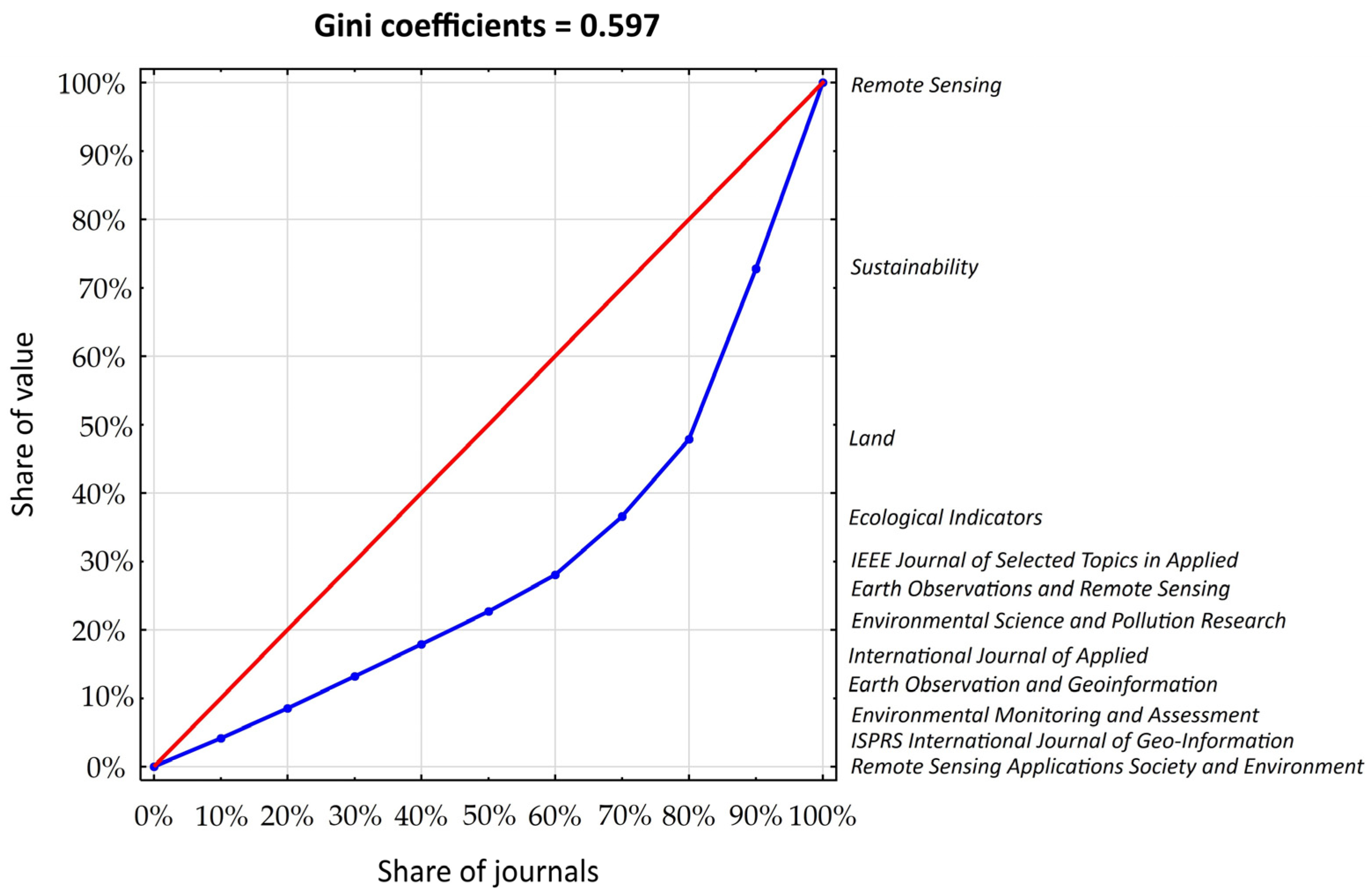
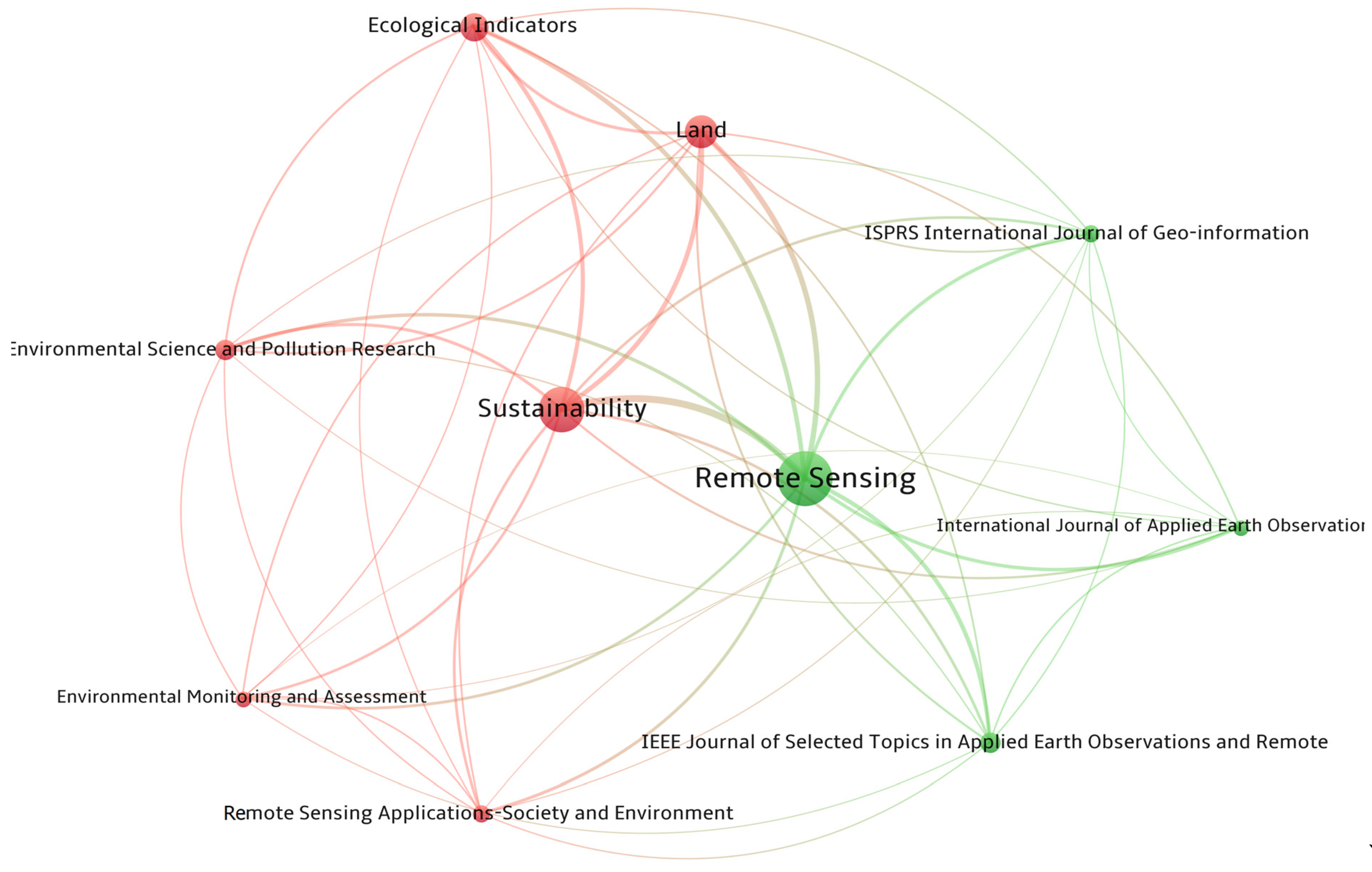
Figure 1. Workflow schema.
Remotesensing 17 01537 g001
Figure 2. PRISMA flow diagram of the systematic literature review search adapted from [23].
Remotesensing 17 01537 g002
Figure 3. Publications and cumulative citations in 1995–2024.
Remotesensing 17 01537 g003
Figure 4. Journal inequality; line of perfect equality (red line), Lorenz curve—unequal distribution (blue line).
Remotesensing 17 01537 g004
Figure 5. Bibliographic coupling of the most productive journals.
Remotesensing 17 01537 g005
Figure 6. Total association strength between authors publishing in international teams.
Remotesensing 17 01537 g006
Figure 7. Links between cooperating countries based on association strength.
Remotesensing 17 01537 g007
Figure 8. Grouping and linking of keywords by association strength.
Remotesensing 17 01537 g008
Figure 9. System of sustainable land management: six iuncta in uno.
Remotesensing 17 01537 g009
Table 1. Most productive journals, ordered by total number of publications.
JournalTP 1IF 2IF 5 (R) 3TC 4CPP 5AU 6CU Countries 7
Remote Sensing1694.24.9 (4)350170.2933China (67.5), USA (16.8), Italy (5.9)
Sustainability1553.33.6 (5)195762.6798China (68.4), USA (5.8), Egypt (5.2)
Land703.23.4 (6)74467.0342China (72.9), Germany (7.1), USA (7.1)
Ecological Indicators537.06.6 (2)141165.0295China (67.5), USA (16.8), Bangladesh (3.7), England (3.7), Germany (3.7)
IEEE Journal of Selected Topics in Applied Earth Observations and Remote Sensing334.75.0 (3)41163.1180China (93.9), USA (6.1), Australia (6.1), Germany (6.1), Pakistan (6.1)
Environmental Science
and Pollution Research
3000.99 (10)36868.0133China (70.0), Iran (13.3), Saudi Arabia (13.3), Egypt (10.0)
Environmental Monitoring and Assessment292.93.1 (7)59960.0105India (34.5), China (13.8), Turkey (13.9), Egypt (6.9)
International Journal of Applied Earth Observation and Geoinformation297.67.5 (1)58055.1160China (62.1), USA (17.2), Canada (13.8), England (13.8), Australia (10.3)
ISPRS International Journal
of Geo-Information
272.83.0 (8)65656.2139China (44.4), Italy (11.1), Netherlands (11.1), Germany (7.4)
Remote Sensing Applications: Society and Environment263.80.0 (9)56477.9108India (30.8), USA (23.1), Bangladesh (19.2), Nigeria (11.5), China (11.5)
1 TP: total number of publications, 2 IF: 2023 ISI impact factor, 3 IF 5 (R): 5-year impact factor, R: rank; 4 TC: total citations, 5 CPP: cited references per publication, 6 AU: total number of authors, 7 CU: countries (% of all publication, TP).
Table 2. The most productive authors.
Author, AffiliationNo. of
Documents
No. of
Citations
Research Topics
Guo Huadong, China International Research Center of Big Data for Sustainable Development Goals12221Drought, settlement, urban SDG indicators
Lu Linlin, Chinese Academy of Sciences12217Air pollution, heat-related health risk, land use changes
Li Xuecao, USA Iowa State University11861Image classification, built-up height, urban heat
Kuffer Monika, Netherlands University of Twente10374Informal urbanization (slums), urban sprawl
Li Qingting, Chinese Academy of Sciences10198Sensors, image classification, environmental monitoring
Zhou Yuyu, University of Hong Kong9689Nighttime light (NTL) satellite, heat island, imperviousness
Murayama Yuji, Japan University of Tsukuba8412Land use change, land use efficiency, surface temperature, heat island
Sun ZhongChang, Chinese Academy of Sciences8166Ecosystems, SDG indicators
Tariq Aqil, USA Mississippi State University8136Land use change, land temperature, cropland, image classification
Weng Qihao, Hong Kong Polytechnic University8280Image classification, cooling effect, landscape
Table 3. The most frequently appearing keywords.
KeywordsOccurrence Total Link StrengthCluster
Remote sensing367712blue
LULC (land use and land cover)218493blue
Urbanization166319red
Sustainable development146302green
GIS (geographic information system)163302blue
LUCCS (land use and land cover change)153294red
Land surface temperature (LST)104189yellow
SDGs (Sustainable Development Goals)85185green
Google Earth Engine (GEE)62137red
Landsat60134purple
Disclaimer/Publisher’s Note: The statements, opinions and data contained in all publications are solely those of the individual author(s) and contributor(s) and not of MDPI and/or the editor(s). MDPI and/or the editor(s) disclaim responsibility for any injury to people or property resulting from any ideas, methods, instructions or products referred to in the content.

