Comparing Modelled and Remotely Sensed Soil Moisture Products Using In Situ Observations in Liguria, Italy: Evaluation via SWI Filtering and Rescaling Techniques


Highlights
- Rescaled modelled and satellite-based soil moisture (SM) products were compared against the Operational Ground Measurement Network of the Liguria Region.
- Five rescaling methodologies were tested and compared to reduce the systematic biases between the SM products and in situ observations.
- In this case study, the rescaled outputs of the Continuum and HTESSEL models generally outperform the satellite-derived rescaled Soil Water Index.
- For this application, CDF matching techniques and linear regression efficiently reduce bias between the ground measurements and the SM product.
Abstract
1. Introduction
2. Materials and Methods
2.1. Definitions
2.2. Study Area and Case Study
2.3. Dataset
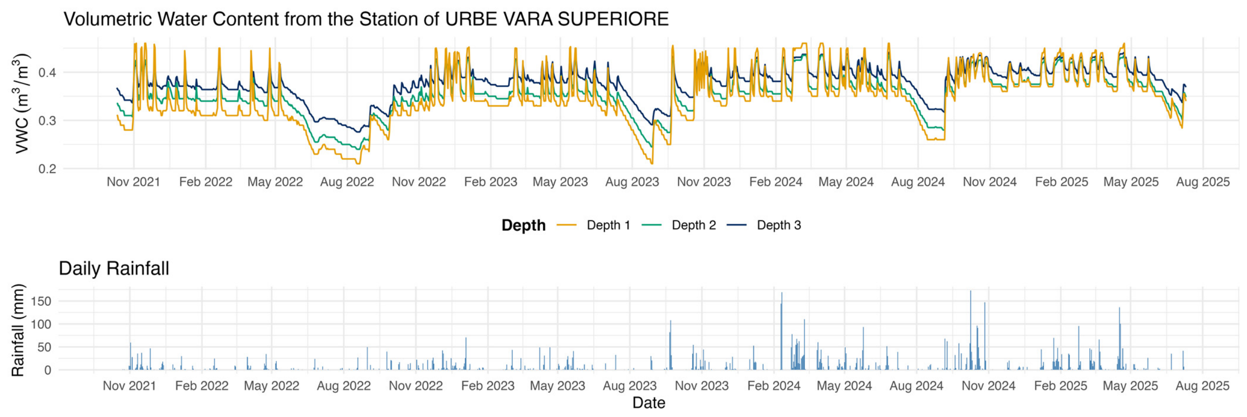
2.3.1. Ground Measurement Network: VWC Time Series
2.3.2. Continuum: Root Zone Soil Moisture
2.3.3. ECMWF: Root Zone Liquid Soil Water Index
2.3.4. SMAP: Surface Soil Moisture
2.3.5. ASCAT: Surface Soil Moisture
2.3.6. Point vs. Pixel Discrepancy
- Starting from the sensors point coordinates (longitude, latitude as in Table 2), the algorithm searches for the nearest grid cell of the dataset using a nearest-neighbour approach. The search is constrained by a maximum search radius (ROIgrid) of 12.5 km to ensure that the selected grid cell is representative of the target location.
- Once the nearest grid cell has been identified, it is used as the centre of a 3 × 3 spatial window, defining the local neighbourhood to be analyzed.
- All grid cells within the 3 × 3 window are evaluated, and only those whose centres lie within a second Region of Interest (ROIpoints) of 12.5 km from the target point are retained.
- The values associated with the selected grid cells are then combined according to the chosen extraction strategy. The representative value for the point is obtained by computing the average of all valid grid cells located within the ROI to mitigate the impact of potential missing values in individual pixels.
2.4. Methodology
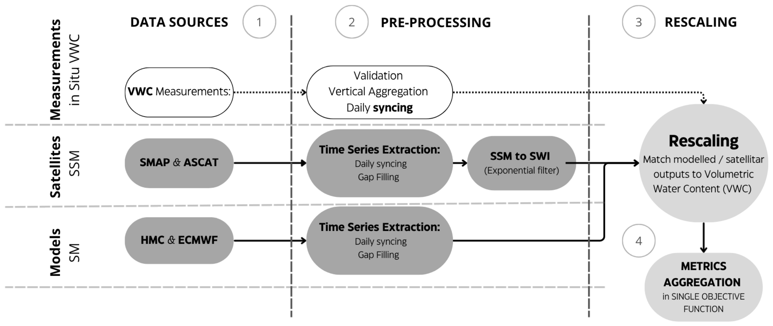
2.4.1. Data Preprocessing
2.4.2. Rescaling Techniques
- Min-Max stretching (min_max) adjusts the minimum and maximum values of the SM product to match those of the reference time series, preserving the relative variability of the original data applying Equation (4).
- The linear regression (linreg) method estimates the coefficients a and b of the linear model in Equation (5) by minimizing the sum of squared errors between the reference series and the SM product.
- The linear rescaling (mean_std) approach normalizes the series by matching its mean and standard deviation to those of the in situ reference, applying Equation (6).
- The Cumulative Distribution Function (CDF) matching techniques are used to minimize the systematic errors between different datasets by matching the Empirical Cumulative Distribution Functions (ECDFs) of the target and reference datasets. This ensures that the rescaled SM value correspond to the reference VWC associated with the same Cumulative probability. In this study, two ECDF interpolation methods were explored: (1) linear interpolation (lin_cdf_match or linear CDF matching) and (2) Beta function interpolation (cdf_beta_match or CDF Beta Matching).
2.4.3. Soil Water Index (SWI)
2.4.4. Performance Evaluation
- The Percent Bias (Pbias) is computed with Equation (9):
- The Pearson R or correlation coefficient (CC) is computed with Equation (10):
2.4.5. Taylor Diagrams
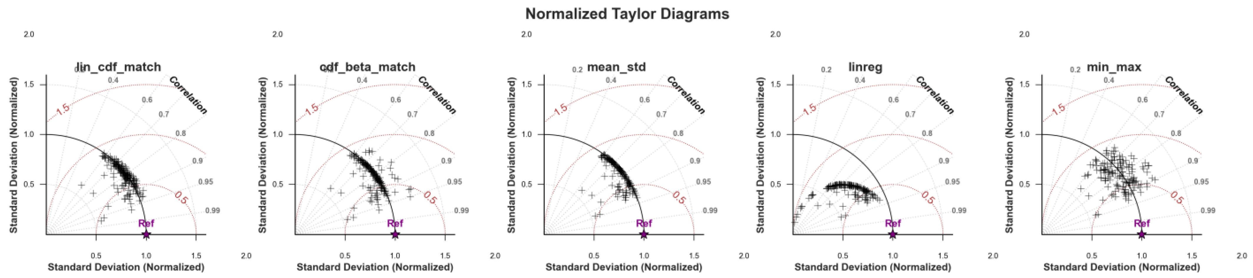
- The normalized standard deviation is represented by the radial distance from the origin to a given point. The solid black arc at a radial distance of 1 represents the normalized standard deviation of the reference dataset (Ref).
- The CC with the reference is represented by the angular coordinate of a point, with dotted radial lines indicating specific correlation values.
- The normalized ubRMSE can be inferred from the distance between the reference marker and a dataset’s point, with dashed brown isolines.
3. Results
3.1. SWI: Identifying the Optimal τ
3.2. Comparison over Different Products, Station Sites and Rescaling Methods
3.3. Test Case: Cuccarello Station
4. Discussion
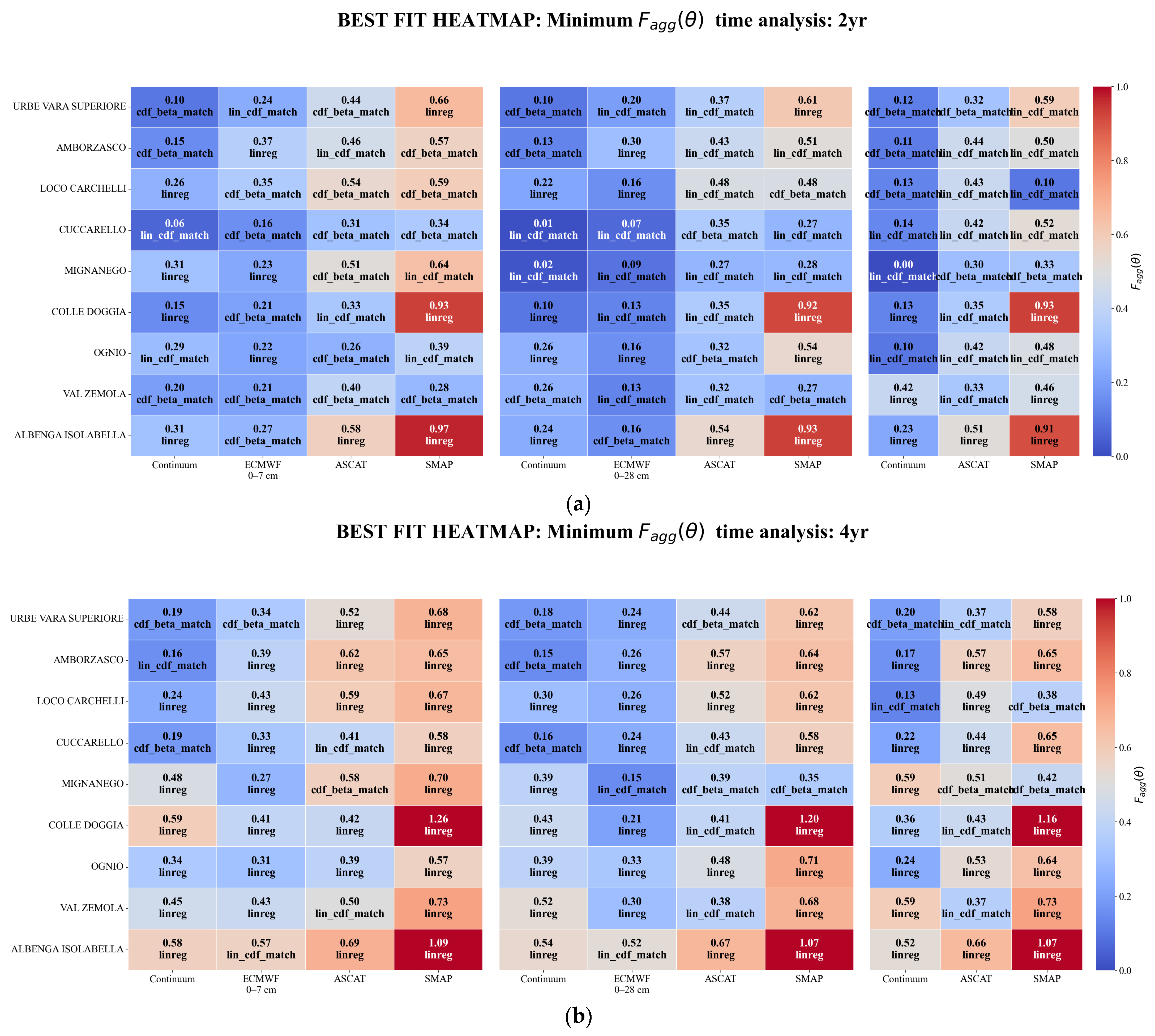
- Model-based rescaled soil moisture products generally outperformed satellite-based estimations in terms of coherence with in situ VWC measurements. Specifically, the Continuum root-zone soil moisture and the ECMWF at 0–28 cm depth products achieved the best performance. Notably, despite its coarser spatial resolution, ECMWF effectively captures soil moisture at sensor depths, likely due to its layered soil representation.
- While ECMWF performance is inherently linked to ASCAT due to data assimilation, the model consistently outperforms the satellite product across all monitoring sites. This suggests that the integration of meteorological forcings (e.g., precipitation and temperature) and the physical modelling of soil water dynamics effectively filter the noise typical of raw satellite signals.
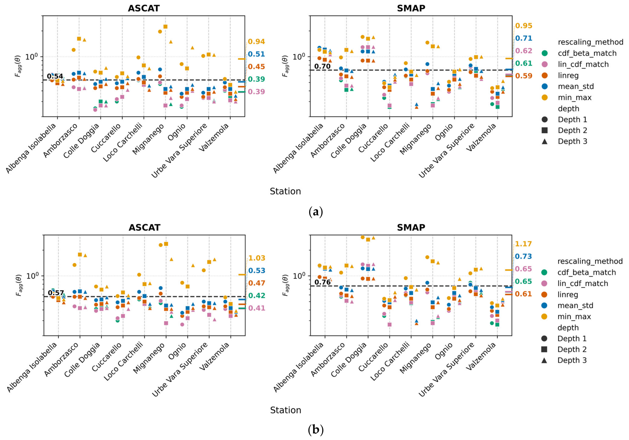
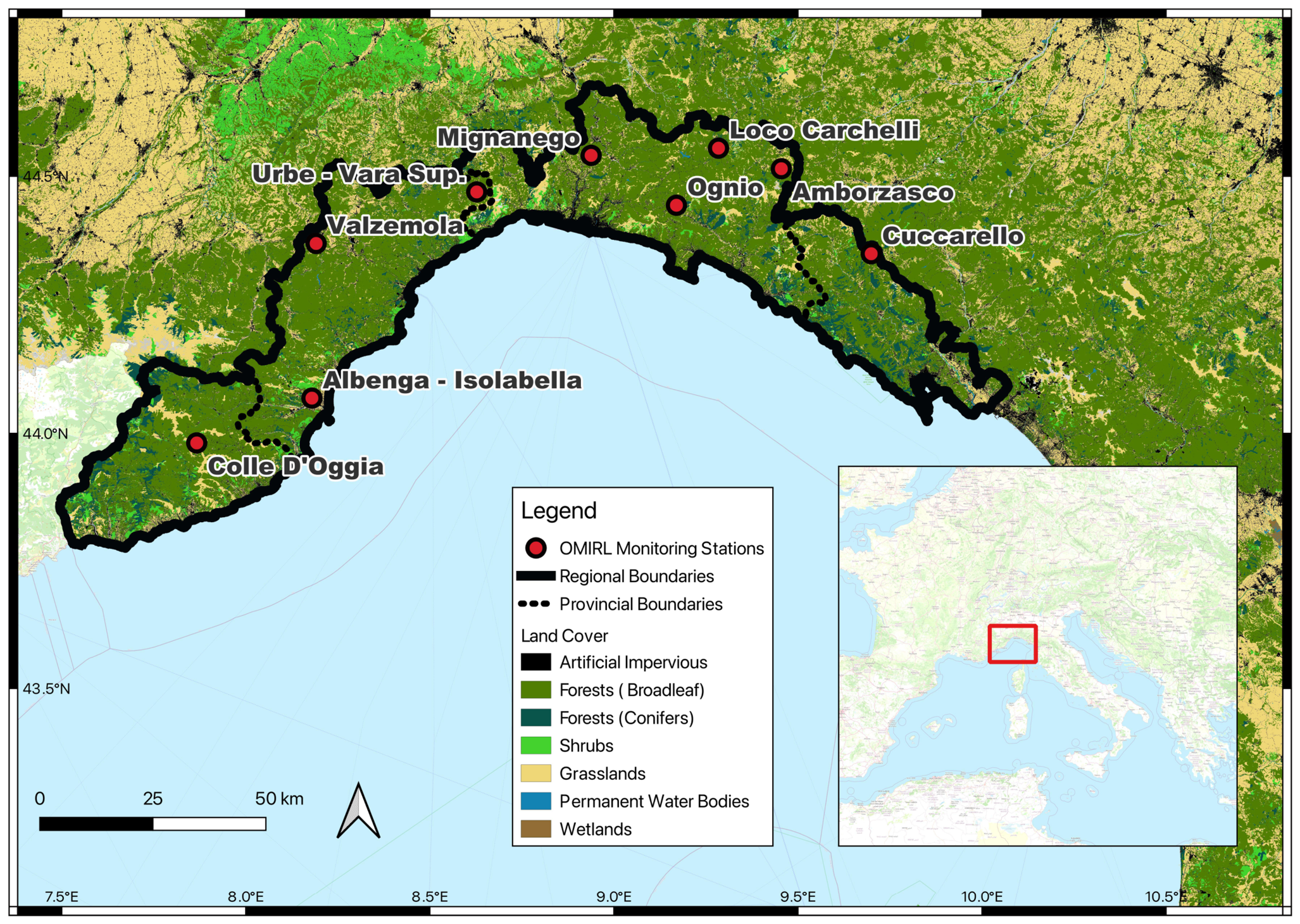
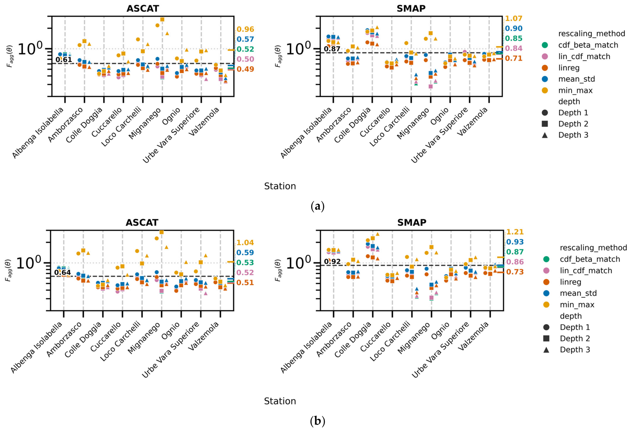
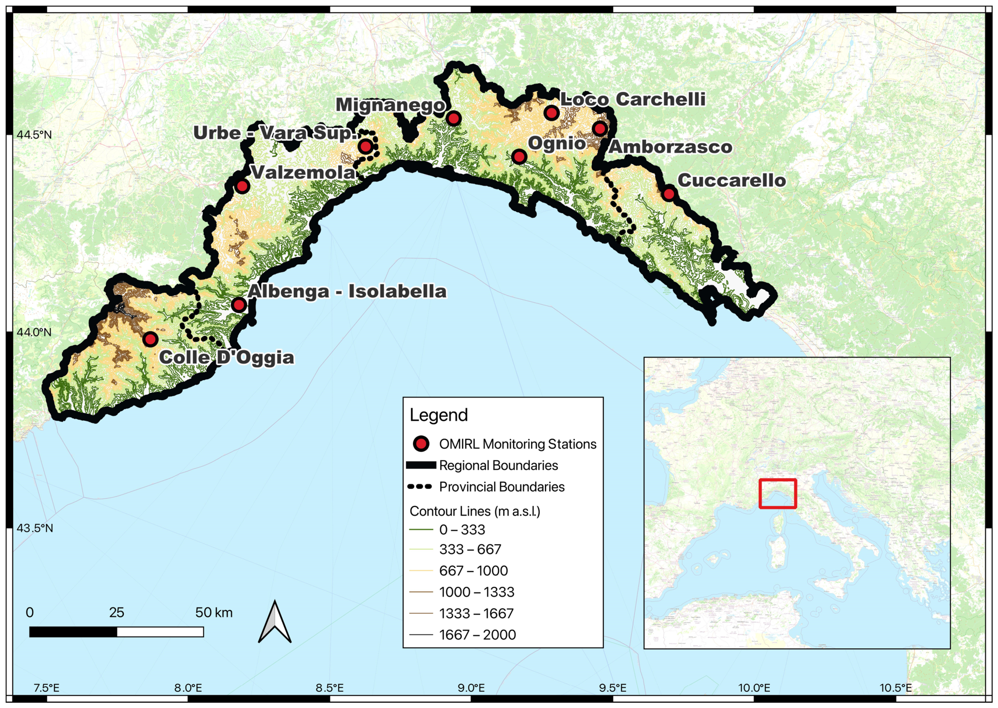
- The degree of coherence varies according to the specific combination of station, depth, and product, often without exhibiting a distinct overall spatial pattern. However, specific sites, such as Albenga Isolabella and Colle D’Oggia, consistently emerge as systematic upper outliers across multiple depths. These locations exhibit particularly high discrepancies, especially in satellite-derived SWI SMAP estimation. These errors are likely driven by topographic complexity, dense forest cover and anthropogenic land use, which amplify retrieval uncertainties. For instance, the extreme elevation variance within coarse satellite footprints (e.g., ranging from 38 to 2090 m within the 12.5 km circular buffer at Colledoggia) introduces severe sub-pixel heterogeneity, thereby degrading the retrieval accuracy. At Albenga Isolabella, the substantial fraction of artificial impervious surfaces (~30% within a 300 m circular buffer) combined with its coastal proximity likely introduces significant radiometric noise into the satellite signals. The two model products (Continuum, HTESSEL) also evidence quite good performance for Albenga Isolabella and Colledoggia, probably because the physical description of soil moisture dynamic through meteorological forcing is less affected by the presence of urban areas interspersed with natural areas than satellite imagery.
- Despite these specific site-level observations, looking at the results and at Table 3, it does not seem easy to directly relate the results in every case (e.g., Figure 6) with the terrain characteristics (land use, vegetations, …). As previously noted, the percentage of artificial surface can explain non-performing score values in ASCAT and SMAP products for Albenga Isolabella but not for Colledoggia. Moreover, the coarse resolution that causes various types of conditions to be averaged in each grid pixel creates difficulties in interpreting results and makes it difficult to pursue rigorous analysis, as comparing these footprints (>10 km) with limited point-scale measurements [32] remains a major, unavoidable source of uncertainty in such a highly heterogeneous landscape.
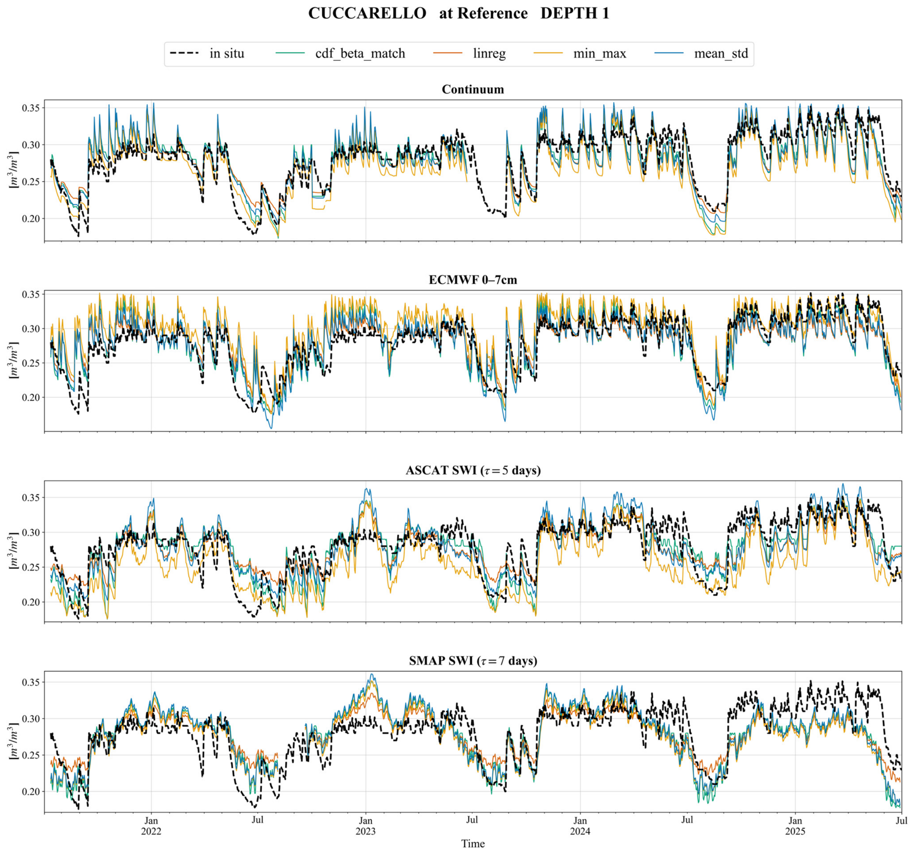
- Consistent with [40], CDF matching (cdf_beta_match and lin_cdf_match) proved to be the best-performing technique among the tested approaches, outperforming both linear rescaling and Min-Max stretching. Moreover, linear regression remains an effective method for reducing biases; it tends to consistently underestimate the temporal variability of the rescaled SM products compared to the reference time series.
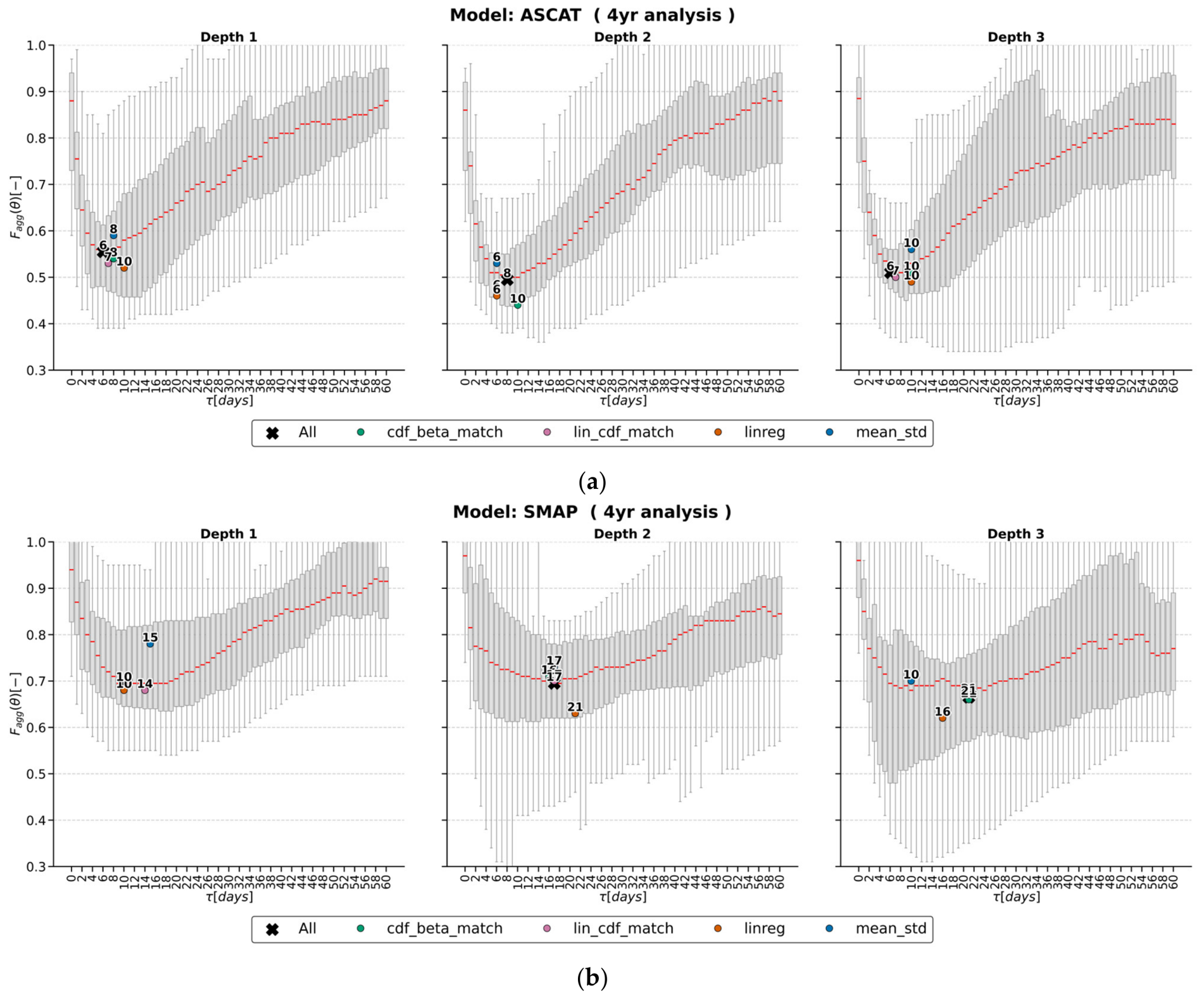
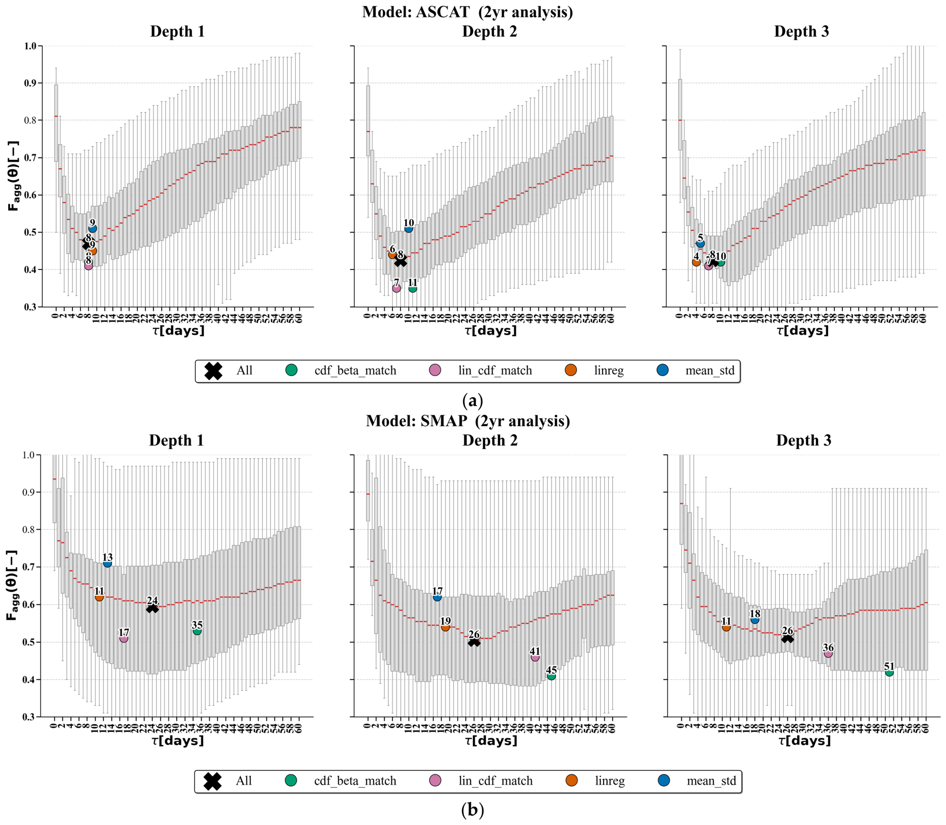
- Regarding the estimation of SM at deeper layers from satellite SSM, the implementation of an exponential filter, following methodologies also used in other Mediterranean catchments [53], allowed for the derivation of the Soil Water Index (SWI). By calibrating the τ parameter against in situ measurements, our analysis identified optimal τ values for ASCAT between 7 and 8 days for depths ranging from 10 to 40 cm. This range appears comparable to the τ value of 9.5 days optimized for measurements obtained at a 25 cm sensor depth reported in the aforementioned study [53], suggesting a general agreement in the parameter’s behaviours within similar Mediterranean environments.
- Shortening the time window analysis from 4 to 2 years improves the agreement between the reference and rescaled time series.
- The application of product-specific τ values for satellite products does not lead to an excessive deterioration in statistical scores compared to locally calibrated parameters. Similar conclusions specifically for ASCAT were also found in [46].
Author Contributions
Funding
Data Availability Statement
Acknowledgments
Conflicts of Interest
Abbreviations
| ATBD | Algorithm Theoretical Basis Document |
| ASCAT | Advanced Scatterometer |
| ARPAL | Agenzia Regionale per la Protezione dell’Ambiente Ligure |
| CFMI-PC | Centro Funzionale Meteo Idrogeologico di Protezione Civile |
| CDF | Cumulative Distribution Function |
| ECDF | Empirical Cumulative Distribution Function |
| ECMWF | European Centre for Medium-Range Weather Forecasts |
| ERS | European Remote Sensing |
| ESA | European Space Agency |
| EUMETSAT | European Organization for the Exploitation of Meteorological Satellites |
| FDR | Frequency Domain Reflectometry |
| HMC | Hydrological Model Continuum |
| H-SAF | Satellite Application Facility on Support to Operational Hydrology and Water Management |
| HTESSEL | Hydrology Tiled ECMWF Scheme of Surface Exchanges over Land |
| METOP | Meteorological Operational Satellite Program |
| OMIRL | Meteorological and Hydrological Observatory of Liguria |
| RMSE | Root Mean Square Error |
| ROI | Region of Interest |
| RZ | Root Zone |
| RZ LSWI | Root Zone Liquid Soil Water Index |
| SEKF | Simplified Extended Kalman Filter |
| SM | Soil Moisture |
| SMAP | Soil Moisture Active Passive |
| SSM | Surface Soil Moisture |
| SWI | Soil Water Index- Soil Wetness Index |
| TDR | Time Domain Reflectometry |
| ubRMSE | unbiased Root Mean Square Error |
| U.O. CMI | Unità Operativa Centro Meteo Idro |
| VWC | Volumetric Water Content |
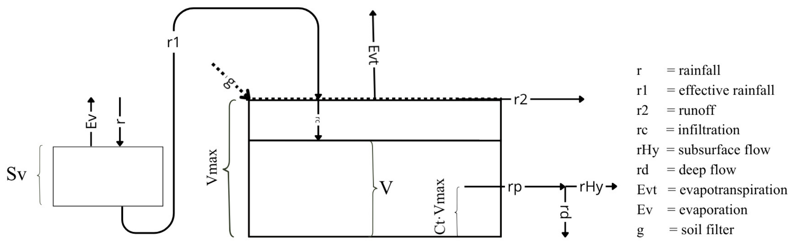
Appendix A. HMC–Subsurface Flow and Evapotranspiration

Appendix B. Land Cover Map of the Study Area

Appendix C. Extended Four-Year Analysis


References
- Scipal, K.; Scheffler, C.; Wagner, W. Soil Moisture-Runoff Relation at the Catchment Scale as Observed with Coarse Resolution Microwave Remote Sensing. Hydrol. Earth Syst. Sci. 2005, 9, 173–183. [Google Scholar] [CrossRef] [Scilit]
- Alfieri, L.; Avanzi, F.; Delogu, F.; Gabellani, S.; Bruno, G.; Campo, L.; Libertino, A.; Massari, C.; Tarpanelli, A.; Rains, D.; et al. High-Resolution Satellite Products Improve Hydrological Modeling in Northern Italy. Hydrol. Earth Syst. Sci. 2022, 26, 3921–3939. [Google Scholar] [CrossRef] [Scilit]
- Peng, J.; Albergel, C.; Balenzano, A.; Brocca, L.; Cartus, O.; Cosh, M.H.; Crow, W.T.; Dabrowska-Zielinska, K.; Dadson, S.; Davidson, M.W.J.; et al. A Roadmap for High-Resolution Satellite Soil Moisture Applications—Confronting Product Characteristics with User Requirements. Remote Sens. Environ. 2021, 252, 112162. [Google Scholar] [CrossRef] [Scilit]
- Dorigo, W.; Wagner, W.; Albergel, C.; Albrecht, F.; Balsamo, G.; Brocca, L.; Chung, D.; Ertl, M.; Forkel, M.; Gruber, A.; et al. ESA CCI Soil Moisture for Improved Earth System Understanding: State-of-the Art and Future Directions. Remote Sens. Environ. 2017, 203, 185–215. [Google Scholar] [CrossRef] [Scilit]
- Brocca, L.; Melone, F.; Moramarco, T.; Wagner, W.; Naeimi, V.; Bartalis, Z.; Hasenauer, S. Potential of ASCAT Soil Moisture Product to Improve Runoff Prediction. In Proceedings of the Symposium Earth Observation and Water Cycle Science, Frascati, Italy, 18–20 November 2009; European Space Agency (ESA): Noordwijk, The Netherlands, 2009; Volume 674, p. 15. [Google Scholar]
- Gruber, A.; Su, C.-H.; Zwieback, S.; Crow, W.; Dorigo, W.; Wagner, W. Recent Advances in (Soil Moisture) Triple Collocation Analysis. Int. J. Appl. Earth Obs. Geoinf. 2016, 45, 200–211. [Google Scholar] [CrossRef] [Scilit]
- Yi, C.; Li, X.; Zeng, J.; Fan, L.; Xie, Z.; Gao, L.; Xing, Z.; Ma, H.; Boudah, A.; Zhou, H.; et al. Assessment of Five SMAP Soil Moisture Products Using ISMN Ground-Based Measurements over Varied Environmental Conditions. J. Hydrol. 2023, 619, 129325. [Google Scholar] [CrossRef] [Scilit]
- Al-Yaari, A.; Wigneron, J.-P.; Dorigo, W.; Colliander, A.; Pellarin, T.; Hahn, S.; Mialon, A.; Richaume, P.; Fernandez-Moran, R.; Fan, L.; et al. Assessment and Inter-Comparison of Recently Developed/Reprocessed Microwave Satellite Soil Moisture Products Using ISMN Ground-Based Measurements. Remote Sens. Environ. 2019, 224, 289–303. [Google Scholar] [CrossRef] [Scilit]
- Feng, S.; Huang, X.; Zhao, S.; Qin, Z.; Fan, J.; Zhao, S. Evaluation of Several Satellite-Based Soil Moisture Products in the Continental US. Sensors 2022, 22, 9977. [Google Scholar] [CrossRef] [Scilit] [PubMed]
- ONeill, P.; Chan, S.; Njoku, E.; Jackson, T.; Bindlish, R.; Chaubell, J.; Colliander, A. SMAP Enhanced L2 Radiometer Half-Orbit 9 Km EASE-Grid Soil Moisture, Version 6; NASA NSIDC DAAC: Boulder, CO, USA, 2023. [CrossRef]
- Chan, S.K.; Bindlish, R.; O’Neill, P.; Jackson, T.; Njoku, E.; Dunbar, S.; Chaubell, J.; Piepmeier, J.; Yueh, S.; Entekhabi, D.; et al. Development and Assessment of the SMAP Enhanced Passive Soil Moisture Product. Remote Sens. Environ. 2018, 204, 931–941. [Google Scholar] [CrossRef] [Scilit] [PubMed]
- Wagner, W.; Hahn, S.; Kidd, R.; Melzer, T.; Bartalis, Z.; Hasenauer, S.; Figa-Saldana, J.; de Rosnay, P.; Jann, A.; Schneider, S.; et al. The ASCAT Soil Moisture Product: A Review of Its Specifications, Validation Results, and Emerging Applications. Meteorol. Z. 2013, 22, 5–33. [Google Scholar] [CrossRef] [Scilit]
- Balsamo, G.; Beljaars, A.; Scipal, K.; Viterbo, P.; van den Hurk, B.; Hirschi, M.; Betts, A.K. A Revised Hydrology for the ECMWF Model: Verification from Field Site to Terrestrial Water Storage and Impact in the Integrated Forecast System. J. Hydrometeorol. 2009, 10, 623–643. [Google Scholar] [CrossRef] [Scilit]
- Silvestro, F.; Gabellani, S.; Delogu, F.; Rudari, R.; Boni, G. Exploiting Remote Sensing Land Surface Temperature in Distributed Hydrological Modelling: The Example of the Continuum Model. Hydrol. Earth Syst. Sci. 2013, 17, 39–62. [Google Scholar] [CrossRef] [Scilit]
- Gruber, A.; De Lannoy, G.; Albergel, C.; Al-Yaari, A.; Brocca, L.; Calvet, J.-C.; Colliander, A.; Cosh, M.; Crow, W.; Dorigo, W.; et al. Validation Practices for Satellite Soil Moisture Retrievals: What Are (the) Errors? Remote Sens. Environ. 2020, 244, 111806. [Google Scholar] [CrossRef] [Scilit]
- Parinussa, R.M.; Meesters, A.G.C.A.; Liu, Y.Y.; Dorigo, W.; Wagner, W.; de Jeu, R.A.M. Error Estimates for Near-Real-Time Satellite Soil Moisture as Derived From the Land Parameter Retrieval Model. IEEE Geosci. Remote Sens. Lett. 2011, 8, 779–783. [Google Scholar] [CrossRef] [Scilit]
- de Nijs, A.H.A.; Parinussa, R.M.; de Jeu, R.A.M.; Schellekens, J.; Holmes, T.R.H. A Methodology to Determine Radio-Frequency Interference in AMSR2 Observations. IEEE Trans. Geosci. Remote Sens. 2015, 53, 5148–5159. [Google Scholar] [CrossRef] [Scilit]
- Wanders, N.; Karssenberg, D.; de Roo, A.; de Jong, S.M.; Bierkens, M.F.P. The Suitability of Remotely Sensed Soil Moisture for Improving Operational Flood Forecasting. Hydrol. Earth Syst. Sci. 2014, 18, 2343–2357. [Google Scholar] [CrossRef] [Scilit]
- Kwon, Y.; Liu, P.-W.; Navari, M.; Bindlish, R.; Kemp, E.M.; Wegiel, J.W.; Jalilvand, E.; Kumar, S.V. Development of Low Latency, High Resolution SMAP Soil Moisture Retrievals in Support of near-Real-Time Applications. Front. Earth Sci. 2026, 14, 1854083. [Google Scholar] [CrossRef] [Scilit]
- AllertaLiguria—Protezione Civile: Chi Fa Cosa. Available online: https://allertaliguria.regione.liguria.it/protezione_civile.php (accessed on 6 November 2025).
- Rebora, N.; Molini, L.; Casella, E.; Comellas, A.; Fiori, E.; Pignone, F.; Siccardi, F.; Silvestro, F.; Tanelli, S.; Parodi, A. Extreme Rainfall in the Mediterranean: What Can We Learn from Observations? J. Hydrometeorol. 2013, 14, 906–922. [Google Scholar] [CrossRef] [Scilit]
- Silvestro, F.; Parodi, A.; Campo, L.; Ferraris, L. Analysis of the Streamflow Extremes and Long-Term Water Balance in the Liguria Region of Italy Using a Cloud-Permitting Grid Spacing Reanalysis Dataset. Hydrol. Earth Syst. Sci. 2018, 22, 5403–5426. [Google Scholar] [CrossRef] [Scilit]
- Giannoni, F.; Roth, G.; Rudari, R. A Procedure for Drainage Network Identification from Geomorphology and Its Application to the Prediction of the Hydrologic Response. Adv. Water Resour. 2005, 28, 567–581. [Google Scholar] [CrossRef] [Scilit]
- Gabellani, S.; Silvestro, F.; Rudari, R.; Boni, G. General Calibration Methodology for a Combined Horton-SCS Infiltration Scheme in Flash Flood Modeling. Nat. Hazards Earth Syst. Sci. 2008, 8, 1317–1327. [Google Scholar] [CrossRef] [Scilit]
- Poggio, L.; de Sousa, L.M.; Batjes, N.H.; Heuvelink, G.B.M.; Kempen, B.; Ribeiro, E.; Rossiter, D. SoilGrids 2.0: Producing Soil Information for the Globe with Quantified Spatial Uncertainty. SOIL 2021, 7, 217–240. [Google Scholar] [CrossRef] [Scilit]
- Davolio, S.; Silvestro, F.; Gastaldo, T. Impact of Rainfall Assimilation on High-Resolution Hydrometeorological Forecasts over Liguria, Italy. J. Hydrometeorol. 2017, 18, 2659–2680. [Google Scholar] [CrossRef] [Scilit]
- Albergel, C.; Dutra, E.; Munier, S.; Calvet, J.-C.; Munoz-Sabater, J.; de Rosnay, P.; Balsamo, G. ERA-5 and ERA-Interim Driven ISBA Land Surface Model Simulations: Which One Performs Better? Hydrol. Earth Syst. Sci. 2018, 22, 3515–3532. [Google Scholar] [CrossRef] [Scilit]
- de Rosnay, P.; Drusch, M.; Vasiljevic, D.; Balsamo, G.; Albergel, C.; Isaksen, L. A Simplified Extended Kalman Filter for the Global Operational Soil Moisture Analysis at ECMWF. Q. J. R. Meteorol. Soc. 2013, 139, 1199–1213. [Google Scholar] [CrossRef] [Scilit]
- Fairbairn, D.; de Rosnay, P. Algorithm Theoretical Baseline Document (ATBD) H26; EUMETSAT: Darmstadt, Germany, 2021. [Google Scholar]
- Fairbairn, D.; de Rosnay, P. Algorithm Theoretical Baseline Document (ATBD) H141 and H142; EUMETSAT: Darmstadt, Germany, 2020. [Google Scholar]
- Entekhabi, D.; Njoku, E.G.; O’Neill, P.E.; Kellogg, K.H.; Crow, W.T.; Edelstein, W.N.; Entin, J.K.; Goodman, S.D.; Jackson, T.J.; Johnson, J.; et al. The Soil Moisture Active Passive (SMAP) Mission. Proc. IEEE 2010, 98, 704–716. [Google Scholar] [CrossRef] [Scilit]
- Colliander, A.; Jackson, T.J.; Bindlish, R.; Chan, S.; Das, N.; Kim, S.B.; Cosh, M.H.; Dunbar, R.S.; Dang, L.; Pashaian, L.; et al. Validation of SMAP Surface Soil Moisture Products with Core Validation Sites. Remote Sens. Environ. 2017, 191, 215–231. [Google Scholar] [CrossRef] [Scilit]
- Chan, S. Enhanced Level 2 Passive Soil Moisture Product Specification Document; JPL D-56291; Jet Propulsion Laboratory California Institute of Technology: Pasadena, CA, USA, 2019. [Google Scholar]
- Poe, G.A. Optimum Interpolation of Imaging Microwave Radiometer Data. IEEE Trans. Geosci. Remote Sens. 1990, 28, 800–810. [Google Scholar] [CrossRef] [Scilit]
- Chaubell, J.; Chan, S.; Dunbar, R.; Peng, J.; Yueh, S. SMAP Enhanced L1C Radiometer Half-Orbit 9 Km EASE-Grid Brightness Temperatures; NASA National Snow and Ice Data Center Distributed Active Archive Center: Boulder, CO, USA, 2018.
- Hahn, S. Algorithm Theoretical Baseline Document (ATBD) Surface Soil Moisture ASCAT NRT Orbit (H101, H102, H16, H103, H106, H107); EUMETSAT: Darmstadt, Germany, 2016. [Google Scholar]
- Wagner, W.; Lemoine, G.; Rott, H. A Method for Estimating Soil Moisture from ERS Scatterometer and Soil Data. Remote Sens. Environ. 1999, 70, 191–207. [Google Scholar] [CrossRef] [Scilit]
- New Global Hydrography Derived From Spaceborne Elevation Data—Lehner—2008—Eos, Transactions American Geophysical Union—Wiley Online Library; Available online: https://agupubs.onlinelibrary.wiley.com/doi/10.1029/2008EO100001 (accessed on 30 July 2026).
- ISPRA Copertura Del Suolo 2023: Uso, Copertura e Consumo di Suolo. Available online: https://groupware.sinanet.isprambiente.it/uso-copertura-e-consumo-di-suolo/library/copertura-del-suolo/carta-di-copertura-del-suolo/copertura-del-suolo-2023 (accessed on 4 April 2026).
- Brocca, L.; Melone, F.; Moramarco, T.; Wagner, W.; Albergel, C. Scaling and Filtering Approaches for the Use of Satellite Soil Moisture Observations. Remote Sens. Energy Fluxes Soil Moisture Content 2013, 1, 411–426. [Google Scholar] [CrossRef] [Scilit]
- Scipal, K.; Drusch, M.; Wagner, W. Assimilation of a ERS Scatterometer Derived Soil Moisture Index in the ECMWF Numerical Weather Prediction System. Adv. Water Resour. 2008, 31, 1101–1112. [Google Scholar] [CrossRef] [Scilit]
- Jackson, T.J.; Cosh, M.H.; Bindlish, R.; Starks, P.J.; Bosch, D.D.; Seyfried, M.; Goodrich, D.C.; Moran, M.S.; Du, J. Validation of Advanced Microwave Scanning Radiometer Soil Moisture Products. IEEE Trans. Geosci. Remote Sens. 2010, 48, 4256–4272. [Google Scholar] [CrossRef] [Scilit]
- Lacava, T.; Brocca, L.; Calice, G.; Melone, F.; Moramarco, T.; Pergola, N.; Tramutoli, V. Soil Moisture Variations Monitoring by AMSU-Based Soil Wetness Indices: A Long-Term Inter-Comparison with Ground Measurements. Remote Sens. Environ. 2010, 114, 2317–2325. [Google Scholar] [CrossRef] [Scilit]
- Madsen, H. Automatic Calibration of a Conceptual Rainfall–Runoff Model Using Multiple Objectives. J. Hydrol. 2000, 235, 276–288. [Google Scholar] [CrossRef] [Scilit]
- Madsen, H.; Wilson, G.; Ammentorp, H.C. Comparison of Different Automated Strategies for Calibration of Rainfall-Runoff Models. J. Hydrol. 2002, 261, 48–59. [Google Scholar] [CrossRef] [Scilit]
- Brocca, L.; Melone, F.; Moramarco, T.; Wagner, W.; Hasenauer, S. ASCAT Soil Wetness Index Validation through in Situ and Modeled Soil Moisture Data in Central Italy. Remote Sens. Environ. 2010, 114, 2745–2755. [Google Scholar] [CrossRef] [Scilit]
- Draper, C.S.; Walker, J.P.; Steinle, P.J.; de Jeu, R.A.M.; Holmes, T.R.H. An Evaluation of AMSR–E Derived Soil Moisture over Australia. Remote Sens. Environ. 2009, 113, 703–710. [Google Scholar] [CrossRef] [Scilit]
- Taylor, K.E. Summarizing Multiple Aspects of Model Performance in a Single Diagram. J. Geophys. Res. Atmos. 2001, 106, 7183–7192. [Google Scholar] [CrossRef] [Scilit]
- Entekhabi, D.; Reichle, R.H.; Koster, R.D.; Crow, W.T. Performance Metrics for Soil Moisture Retrievals and Application Requirements. J. Hydrometeorol. 2010, 11, 832–840. [Google Scholar] [CrossRef] [Scilit]
- Pascale, S.; Ragone, F. Widespread Multi-Year Droughts in Italy: Identification and Causes of Development. Int. J. Climatol. 2025, 45, e8827. [Google Scholar] [CrossRef] [Scilit]
- Xing, Z.; Fan, L.; Zhao, L.; De Lannoy, G.; Frappart, F.; Peng, J.; Li, X.; Zeng, J.; Al-Yaari, A.; Yang, K.; et al. A First Assessment of Satellite and Reanalysis Estimates of Surface and Root-Zone Soil Moisture over the Permafrost Region of Qinghai-Tibet Plateau. Remote Sens. Environ. 2021, 265, 112666. [Google Scholar] [CrossRef] [Scilit]
- Beck, H.E.; Pan, M.; Miralles, D.G.; Reichle, R.H.; Dorigo, W.A.; Hahn, S.; Sheffield, J.; Karthikeyan, L.; Balsamo, G.; Parinussa, R.M.; et al. Evaluation of 18 Satellite- and Model-Based Soil Moisture Products Using in Situ Measurements from 826 Sensors. Hydrol. Earth Syst. Sci. 2021, 25, 17–40. [Google Scholar] [CrossRef] [Scilit]
- Massari, C.; Brocca, L.; Barbetta, S.; Papathanasiou, C.; Mimikou, M.; Moramarco, T. Using Globally Available Soil Moisture Indicators for Flood Modelling in Mediterranean Catchments. Hydrol. Earth Syst. Sci. 2014, 18, 839–853. [Google Scholar] [CrossRef] [Scilit]
- Mohite, J.; Sawant, S.; Pandit, A.; Pappula, S. Spatial Downscaling of Smap Soil Moisture Using the Modis and Srtm Observations. Int. Arch. Photogramm. Remote Sens. Spat. Inf. Sci. 2022, XLIII-B3-2022, 933–938. [Google Scholar] [CrossRef] [Scilit]
- Peng, J.; Loew, A.; Merlin, O.; Verhoest, N.E.C. A Review of Spatial Downscaling of Satellite Remotely Sensed Soil Moisture. Rev. Geophys. 2017, 55, 341–366. [Google Scholar] [CrossRef] [Scilit]
- Afshar, M.H.; Yilmaz, M.T.; Crow, W.T. Impact of Rescaling Approaches in Simple Fusion of Soil Moisture Products. Water Resour. Res. 2019, 55, 7804–7825. [Google Scholar] [CrossRef] [Scilit]
- Yilmaz, M.T.; Crow, W.T.; Ryu, D. Impact of Model Relative Accuracy in Framework of Rescaling Observations in Hydrological Data Assimilation Studies. J. Hydrometeorol. 2016, 17, 2245–2257. [Google Scholar] [CrossRef] [Scilit]
- Stroud, P. A Recursive Exponential Filter for Time-Sensitive Data; Los Alamos National Laboratory: Los Alamos, NM, USA, 1999.
- Albergel, C.; Rüdiger, C.; Carrer, D.; Calvet, J.-C.; Fritz, N.; Naeimi, V.; Bartalis, Z.; Hasenauer, S. An Evaluation of ASCAT Surface Soil Moisture Products with In-Situ Observations in Southwestern France. Hydrol. Earth Syst. Sci. 2009, 13, 115–124. [Google Scholar] [CrossRef] [Scilit]
- Albergel, C.; Rüdiger, C.; Pellarin, T.; Calvet, J.-C.; Fritz, N.; Froissard, F.; Suquia, D.; Petitpa, A.; Piguet, B.; Martin, E. From Near-Surface to Root-Zone Soil Moisture Using an Exponential Filter: An Assessment of the Method Based on in-Situ Observations and Model Simulations. Hydrol. Earth Syst. Sci. 2008, 12, 1323–1337. [Google Scholar] [CrossRef] [Scilit]
- Laiolo, P.; Gabellani, S.; Campo, L.; Cenci, L.; Silvestro, F.; Delogu, F.; Boni, G.; Rudari, R.; Puca, S.; Pisani, A.R. Assimilation of Remote Sensing Observations into a Continuous Distributed Hydrological Model: Impacts on the Hydrologic Cycle. In Proceedings of the 2015 IEEE International Geoscience and Remote Sensing Symposium (IGARSS), Milan, Italy, 26–31 July 2015; pp. 1308–1311. [Google Scholar]
- Ortenzi, S.; Cencetti, C.; Mincu, F.-I.; Neculau, G.; Chendeş, V.; Ciabatta, L.; Massari, C.; Di Matteo, L. Comparing Satellite Soil Moisture Products Using In Situ Observations over an Instrumented Experimental Basin in Romania. Remote Sens. 2024, 16, 3283. [Google Scholar] [CrossRef] [Scilit]
- Hjerdt, K.N.; McDonnell, J.J.; Seibert, J.; Rodhe, A. A New Topographic Index to Quantify Downslope Controls on Local Drainage. Water Resour. Res. 2004, 40, W05602. [Google Scholar] [CrossRef] [Scilit]




| Source | Type | Instrument/Model | Product | Spatial Resolution | Temporal Resolution | Data Availability | SM-Output | Units |
|---|---|---|---|---|---|---|---|---|
| OMIRL | Point Measurement | FDR-Sensor | - | In situ | 1 h | 2021-now | SM | VWC [m3 m−3] |
| ASCAT | Satellite | C-band VV-Radar | H16 | ~12.5 km | ~1 day | 2007-now | SSM | S [m3 m−3] |
| SMAP | Satellite | L-band Radiometer | L2SMP_E | ~9 km | ~0.5 day | 2015-now | SSM | VWC [m3 m−3] |
| HMC | Modelled | Hydrological Model | - | ~200 m | 1 h | 2006-now | RZ SM | S [m3 m−3] |
| HTESSEL | Modelled | Land Surface Model | H142; H26 | ~10 km | 1 day | 1992-now | RZ Liquid SWI | S [m3 m−3] |
| Station | Coordinates (°N, °E) | Elevation [m a.s.l.] | Soil Type | Porosity [-] | Vmax [mm] | RZ Depth [mm] |
|---|---|---|---|---|---|---|
| Amborzasco | 44.51447, 9.45496 | 908 | Compact Clay | 0.59 | 160 | 270 |
| Colle D’Oggia | 43.98131, 7.86667 | 1163 | Draining Porous | 0.55 | 170 | 310 |
| Cuccarello | 44.34967, 9.69908 | 835 | Draining Porous | 0.61 | 137 | 220 |
| Albenga Isolabella | 44.06875, 8.17956 | 36 | - | - | - | - |
| Loco Carchelli | 44.55421, 9.28421 | 600 | Draining Porous | 0.60 | 106 | 180 |
| Mignanego | 44.54028, 8.93816 | 270 | Compact Clay | 0.52 | 157 | 300 |
| Ognio | 44.44372, 9.16994 | 490 | Compact Clay | 0.56 | 197 | 350 |
| Urbe—Vara Sup. | 44.46953, 8.62739 | 810 | Draining Porous | 0.55 | 137 | 250 |
| Valzemola | 44.36959, 8.19105 | 480 | Compact Clay | 0.48 | 126 | 260 |
| Station | Elev. Range [m a.s.l.] | Artificial Impervious [%] | Forests (Conifers + Broadleaf) [%] | Grasslands [%] | * Other [%] |
|---|---|---|---|---|---|
| 300 m buffer | |||||
| Amborzasco | 789–932 | 11 | 43 | 46 | 0 |
| Colle D’Oggia | 897–1257 | 4 | 44 | 53 | 0 |
| Cuccarello | 736–942 | 1 | 79 | 21 | 0 |
| Albenga-Isolabella | 14–37 | 30 | 3 | 64 | 3 |
| Loco Carchelli | 577–674 | 12 | 60 | 20 | 0 |
| Mignanego | 239–396 | 16 | 68 | 15 | 0 |
| Ognio | 339–633 | 9 | 77 | 9 | 5 |
| Urbe Vara S. | 742–869 | 21 | 50 | 29 | 0 |
| Valzemola | 415–504 | 15 | 35 | 49 | 0 |
| 12.5 km buffer | |||||
| Amborzasco | 134–1769 | 2 | 82 | 13 | 3 |
| Colle D’Oggia | 38–2090 | 3 | 82 | 11 | 4 |
| Cuccarello | 106–1592 | 3 | 83 | 11 | 3 |
| Albenga-Isolabella | 0–1342 | 10 | 67 | 14 | 9 |
| Loco Carchelli | 249–1600 | 2 | 86 | 10 | 2 |
| Mignanego | 15–1172 | 7 | 74 | 17 | 3 |
| Ognio | 0–1401 | 6 | 81 | 10 | 3 |
| Urbe Vara S. | 0–1274 | 5 | 69 | 18 | 8 |
| Valzemola | 296–1214 | 5 | 77 | 17 | 1 |
| Model | lin_cdf_match | mean_std | |||||||
|---|---|---|---|---|---|---|---|---|---|
| ubRMSE [m3 m−3] | CC | NSE | Fagg | ubRMSE [m3 m−3] | CC | NSE | Fagg | ||
| Depth 1 | |||||||||
| Continuum | - | 0.020 ± 0.007 | 0.860 ± 0.048 | 0.730 ± 0.096 | 0.230 ± 0.107 | 0.023 ± 0.008 | 0.860 ± 0.036 | 0.720 ± 0.070 | 0.240 ± 0.078 |
| ECMWF 0–7 cm | - | 0.029 ± 0.006 | 0.860 ± 0.035 | 0.710 ± 0.070 | 0.250 ± 0.080 | 0.030 ± 0.007 | 0.860 ± 0.036 | 0.710 ± 0.067 | 0.250 ± 0.075 |
| ASCAT | τopt | 0.032 ± 0.009 | 0.780 ± 0.059 | 0.570 ± 0.115 | 0.410 ± 0.129 | 0.037 ± 0.008 | 0.740 ± 0.053 | 0.490 ± 0.106 | 0.500 ± 0.120 |
| ASCAT | 8 days | 0.034 ± 0.009 | 0.780 ± 0.052 | 0.570 ± 0.107 | 0.410 ± 0.119 | 0.038 ± 0.009 | 0.730 ± 0.051 | 0.470 ± 0.101 | 0.520 ± 0.113 |
| SMAP | τopt | 0.035 ± 0.017 | 0.700 ± 0.159 | 0.390 ± 0.324 | 0.600 ± 0.362 | 0.040 ± 0.015 | 0.640 ± 0.130 | 0.280 ± 0.264 | 0.730 ± 0.292 |
| SMAP | 25 days | 0.035 ± 0.018 | 0.690 ± 0.169 | 0.370 ± 0.348 | 0.630 ± 0.388 | 0.040 ± 0.015 | 0.640 ± 0.138 | 0.280 ± 0.278 | 0.730 ± 0.311 |
| Depth 2 | |||||||||
| Continuum | - | 0.015 ± 0.009 | 0.885 ± 0.049 | 0.760 ± 0.099 | 0.190 ± 0.109 | 0.019 ± 0.010 | 0.865 ± 0.035 | 0.735 ± 0.069 | 0.225 ± 0.077 |
| ECMWF 0–28 cm | - | 0.022 ± 0.006 | 0.890 ± 0.038 | 0.770 ± 0.073 | 0.180 ± 0.082 | 0.022 ± 0.007 | 0.890 ± 0.032 | 0.780 ± 0.065 | 0.170 ± 0.073 |
| ASCAT | τopt | 0.027 ± 0.011 | 0.815 ± 0.047 | 0.635 ± 0.097 | 0.335 ± 0.106 | 0.033 ± 0.010 | 0.740 ± 0.040 | 0.470 ± 0.076 | 0.510 ± 0.086 |
| ASCAT | 8 days | 0.029 ± 0.011 | 0.795 ± 0.044 | 0.595 ± 0.089 | 0.380 ± 0.100 | 0.033 ± 0.010 | 0.735 ± 0.038 | 0.470 ± 0.076 | 0.520 ± 0.086 |
| SMAP | τopt | 0.035 ± 0.019 | 0.730 ± 0.172 | 0.460 ± 0.339 | 0.525 ± 0.381 | 0.038 ± 0.017 | 0.670 ± 0.136 | 0.340 ± 0.270 | 0.660 ± 0.301 |
| SMAP | 25 days | 0.036 ± 0.019 | 0.720 ± 0.177 | 0.450 ± 0.352 | 0.540 ± 0.394 | 0.039 ± 0.017 | 0.675 ± 0.137 | 0.340 ± 0.272 | 0.660 ± 0.305 |
| Depth 3 | |||||||||
| Continuum | - | 0.018 ± 0.014 | 0.910 ± 0.069 | 0.810 ± 0.135 | 0.130 ± 0.151 | 0.020 ± 0.011 | 0.890 ± 0.053 | 0.770 ± 0.107 | 0.180 ± 0.119 |
| ASCAT | τopt | 0.030 ± 0.010 | 0.790 ± 0.046 | 0.570 ± 0.089 | 0.400 ± 0.101 | 0.035 ± 0.009 | 0.720 ± 0.042 | 0.440 ± 0.086 | 0.550 ± 0.096 |
| ASCAT | 8 days | 0.031 ± 0.010 | 0.780 ± 0.038 | 0.570 ± 0.072 | 0.410 ± 0.081 | 0.035 ± 0.009 | 0.720 ± 0.036 | 0.430 ± 0.078 | 0.560 ± 0.088 |
| SMAP | τopt | 0.034 ± 0.016 | 0.740 ± 0.159 | 0.470 ± 0.309 | 0.510 ± 0.348 | 0.037 ± 0.015 | 0.660 ± 0.130 | 0.320 ± 0.260 | 0.680 ± 0.291 |
| SMAP | 25 days | 0.034 ± 0.017 | 0.730 ± 0.169 | 0.470 ± 0.332 | 0.520 ± 0.373 | 0.037 ± 0.015 | 0.660 ± 0.127 | 0.320 ± 0.253 | 0.680 ± 0.284 |
| Rescaling Method | τ [Days] | CC [-] | ubRMSE [m3 m−3] | NSE [-] | Pbias [%] | Fagg(θ) [−] |
|---|---|---|---|---|---|---|
| Continuum | ||||||
| cdf_beta_match | - | 0.88 | 0.018 | 0.76 | 0.0 | 0.19 |
| linreg | - | 0.86 | 0.019 | 0.74 | 0.0 | 0.22 |
| min_max | - | 0.86 | 0.021 | 0.61 | −3.9 | 0.34 |
| mean_std | - | 0.86 | 0.020 | 0.72 | 0.0 | 0.24 |
| ECMWF 0–7 cm | ||||||
| cdf_beta_match | - | 0.81 | 0.024 | 0.62 | 0.0 | 0.35 |
| linreg | - | 0.80 | 0.023 | 0.65 | 0.0 | 0.33 |
| min_max | - | 0.80 | 0.024 | 0.35 | 7.1 | 0.61 |
| mean_std | - | 0.80 | 0.024 | 0.61 | 0.0 | 0.36 |
| ASCAT | ||||||
| cdf_beta_match | 5 | 0.79 | 0.025 | 0.58 | 0.0 | 0.39 |
| linreg | 5 | 0.75 | 0.026 | 0.56 | 0.0 | 0.43 |
| min_max | 5 | 0.75 | 0.028 | 0.12 | −8.2 | 0.84 |
| mean_std | 5 | 0.75 | 0.027 | 0.5 | 0.0 | 0.48 |
| SMAP | ||||||
| cdf_beta_match | 7 | 0.70 | 0.030 | 0.40 | 0.0 | 0.59 |
| linreg | 7 | 0.68 | 0.028 | 0.46 | 0.0 | 0.55 |
| min_max | 7 | 0.68 | 0.030 | 0.37 | −1.8 | 0.63 |
| mean_std | 7 | 0.68 | 0.031 | 0.35 | 0.0 | 0.65 |
Disclaimer/Publisher’s Note: The statements, opinions and data contained in all publications are solely those of the individual author(s) and contributor(s) and not of MDPI and/or the editor(s). MDPI and/or the editor(s) disclaim responsibility for any injury to people or property resulting from any ideas, methods, instructions or products referred to in the content. |
© 2026 by the authors. Licensee MDPI, Basel, Switzerland. This article is an open access article distributed under the terms and conditions of the Creative Commons Attribution (CC BY) license.
Share and Cite
Repetto, L.; Silvestro, F.; Gardella, F.; Boni, G.; Delogu, F. Comparing Modelled and Remotely Sensed Soil Moisture Products Using In Situ Observations in Liguria, Italy: Evaluation via SWI Filtering and Rescaling Techniques. Remote Sens. 2026, 18, 2903. https://doi.org/10.3390/rs18172903
Repetto L, Silvestro F, Gardella F, Boni G, Delogu F. Comparing Modelled and Remotely Sensed Soil Moisture Products Using In Situ Observations in Liguria, Italy: Evaluation via SWI Filtering and Rescaling Techniques. Remote Sensing. 2026; 18(17):2903. https://doi.org/10.3390/rs18172903
Chicago/Turabian StyleRepetto, Luca, Francesco Silvestro, Fabio Gardella, Giorgio Boni, and Fabio Delogu. 2026. "Comparing Modelled and Remotely Sensed Soil Moisture Products Using In Situ Observations in Liguria, Italy: Evaluation via SWI Filtering and Rescaling Techniques" Remote Sensing 18, no. 17: 2903. https://doi.org/10.3390/rs18172903
APA StyleRepetto, L., Silvestro, F., Gardella, F., Boni, G., & Delogu, F. (2026). Comparing Modelled and Remotely Sensed Soil Moisture Products Using In Situ Observations in Liguria, Italy: Evaluation via SWI Filtering and Rescaling Techniques. Remote Sensing, 18(17), 2903. https://doi.org/10.3390/rs18172903