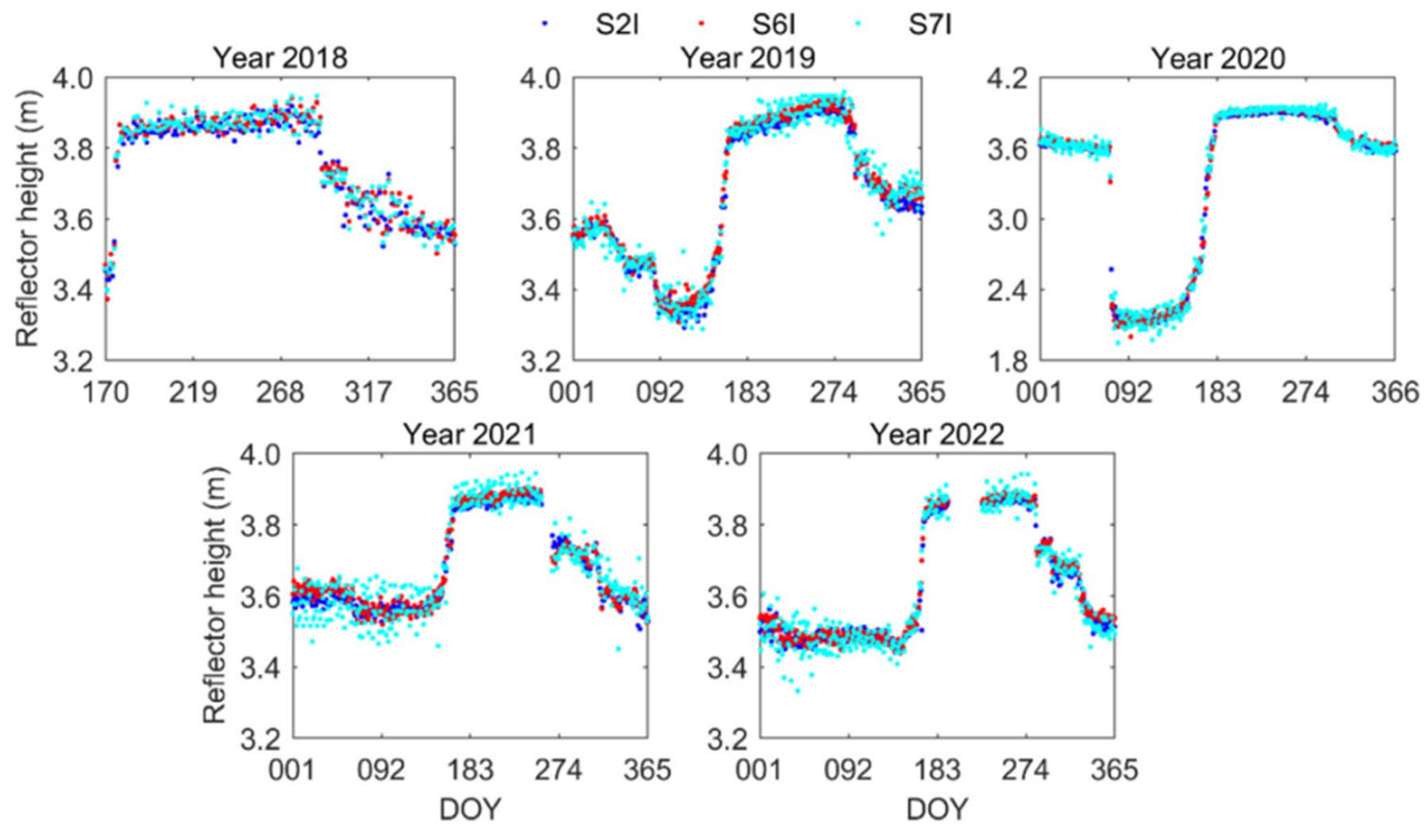
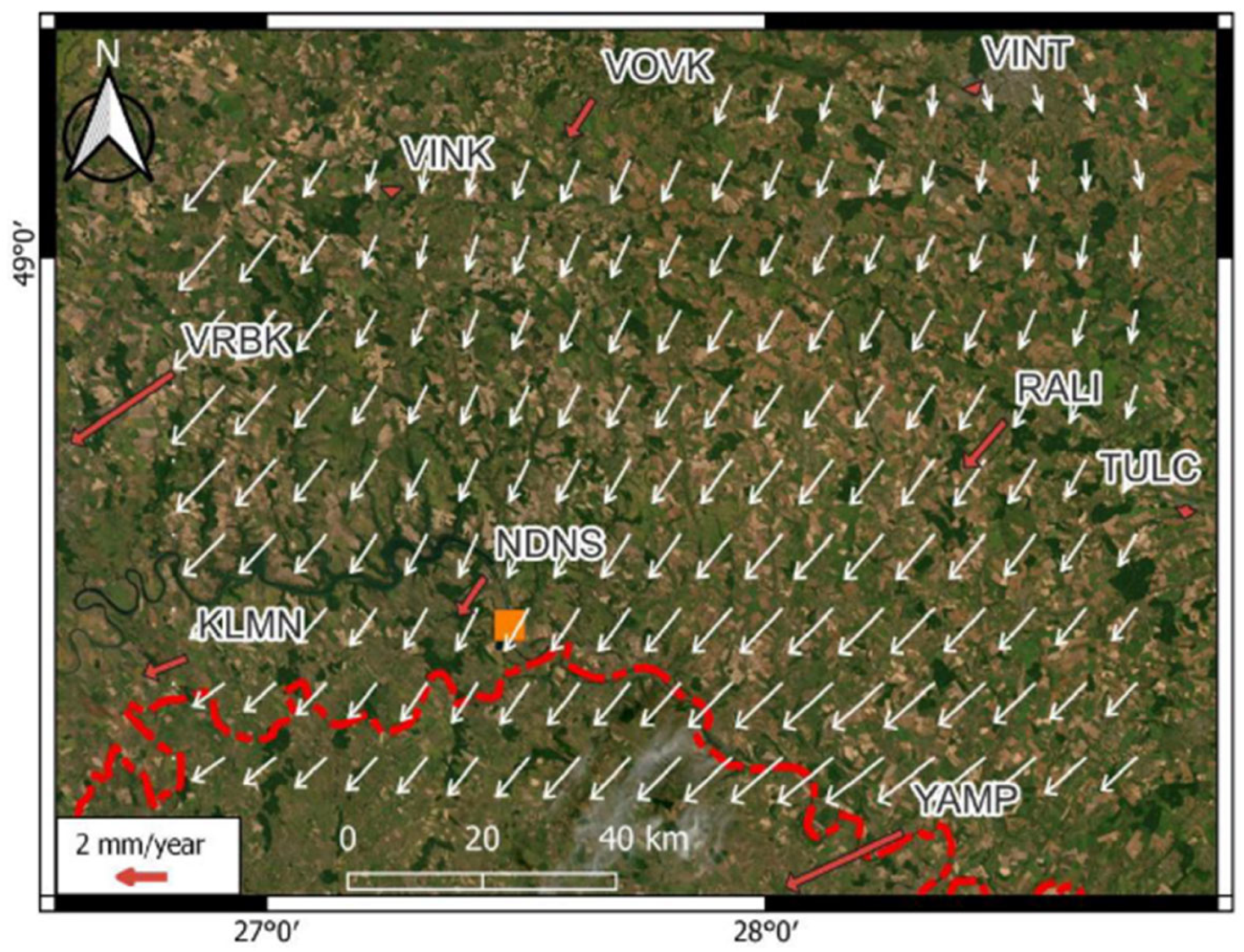
Global Navigation Satellite Systems (GNSS) in Climate Change Research: A Comprehensive Review

Highlights
- A comprehensive cross-disciplinary synthesis of five core GNSS techniques (GNSS-RO, PPP, CORS, GNSS-R, and GNSS-IR) across all primary Earth system spheres (atmosphere, cryosphere, hydrosphere, oceans, biosphere, and lithosphere) is presented.
- Modern GNSS observations provide precise, long-term, and continuous data supporting the monitoring of atmospheric parameters, sea level, snow cover, glaciers, soil moisture, and crustal deformation.
- Integration of GNSS data with other remote sensing techniques increases the capacity to monitor climate processes and improves the quality of meteorological forecasts, environmental analyses, and geophysical models.
- The dynamic development of multi-constellation GNSSs and modern data processing methods will strengthen the role of satellite technologies in monitoring climate change and supporting adaptation and environmental management measures.
- Operational synergetic frameworks combining multi-constellation GNSS with InSAR, satellite altimetry, GRACE-FO gravity missions, and AI-driven predictive modeling for enhanced environmental monitoring and hazard nowcasting are identified.
- The capacity of GNSS to deliver high-resolution continuous physical data (e.g., millimeter-level crustal motion, PWV profiles, or snow depth retrievals) beyond traditional positioning is demonstrated.
Abstract
1. Introduction
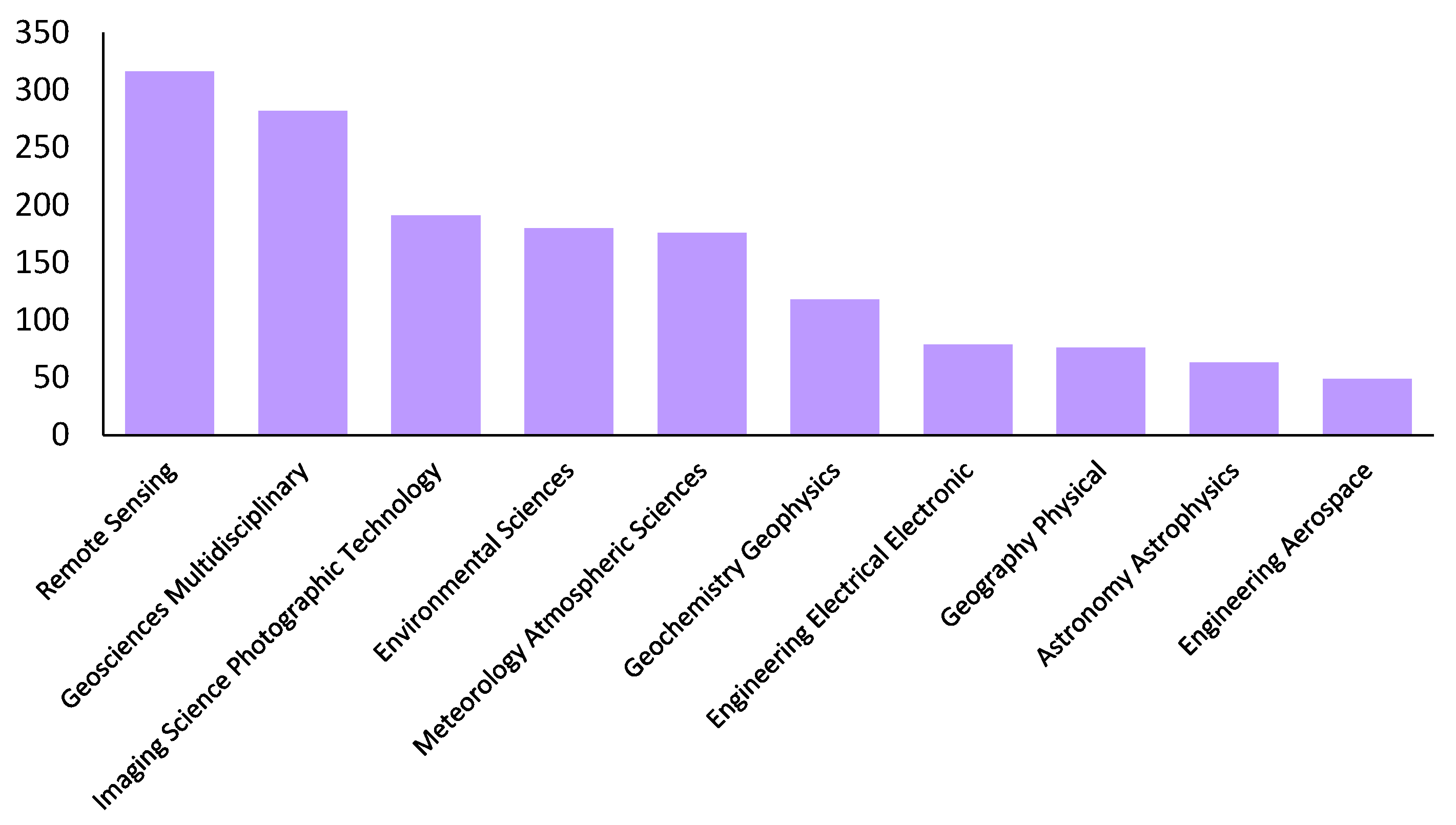
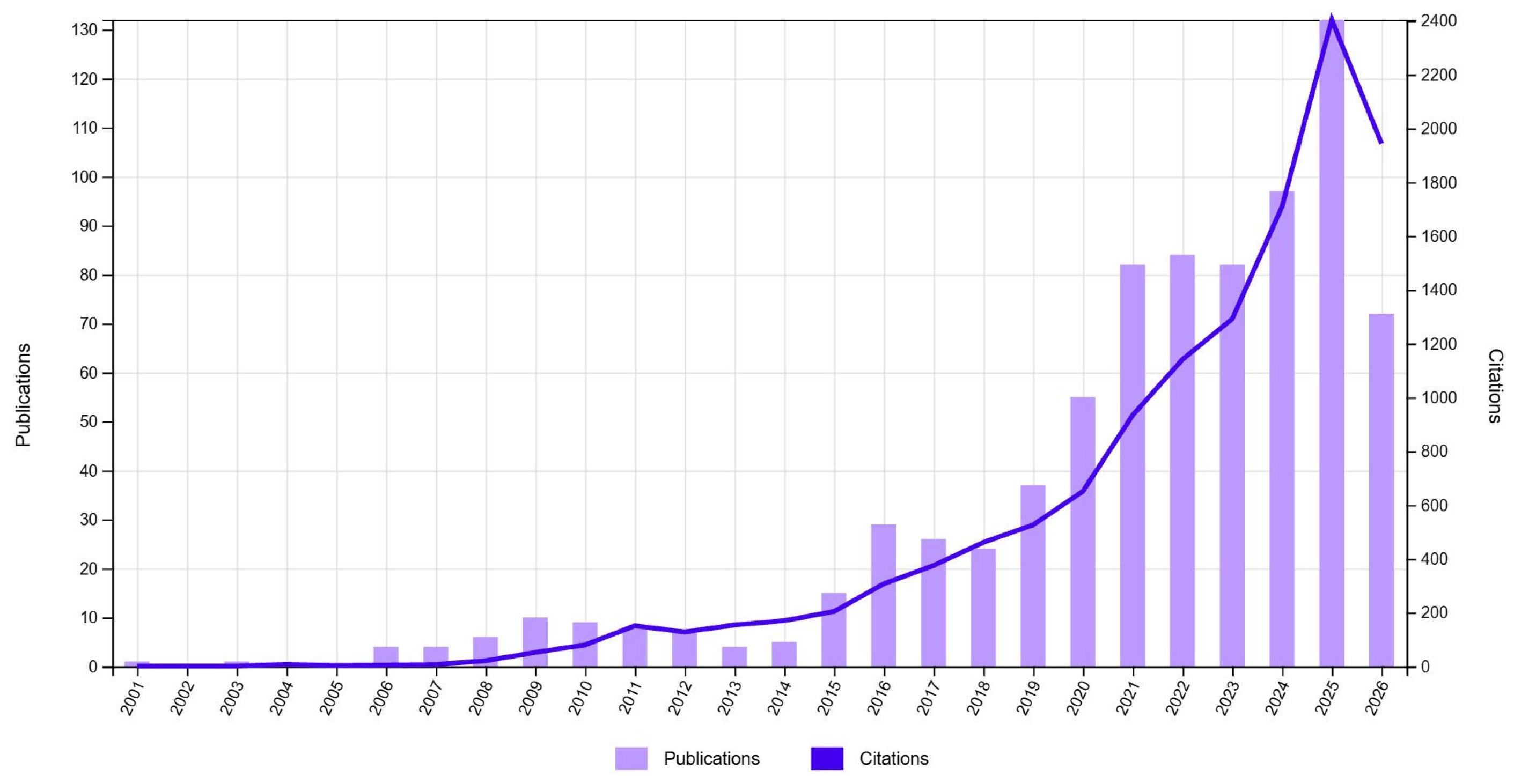
2. Methodology
- The analysis was limited to publications in English;
- Publications from 2000 year onwards were taken into consideration;
- The resulting collection was checked for duplicates and thematic relevance to the research subject;
- Publications that did not meet the adopted criteria were removed from the final collection.
2.1. Strengths and Limitations
2.2. Methodological Recommendations
3. Geodetic Tools for Climate Monitoring Applications
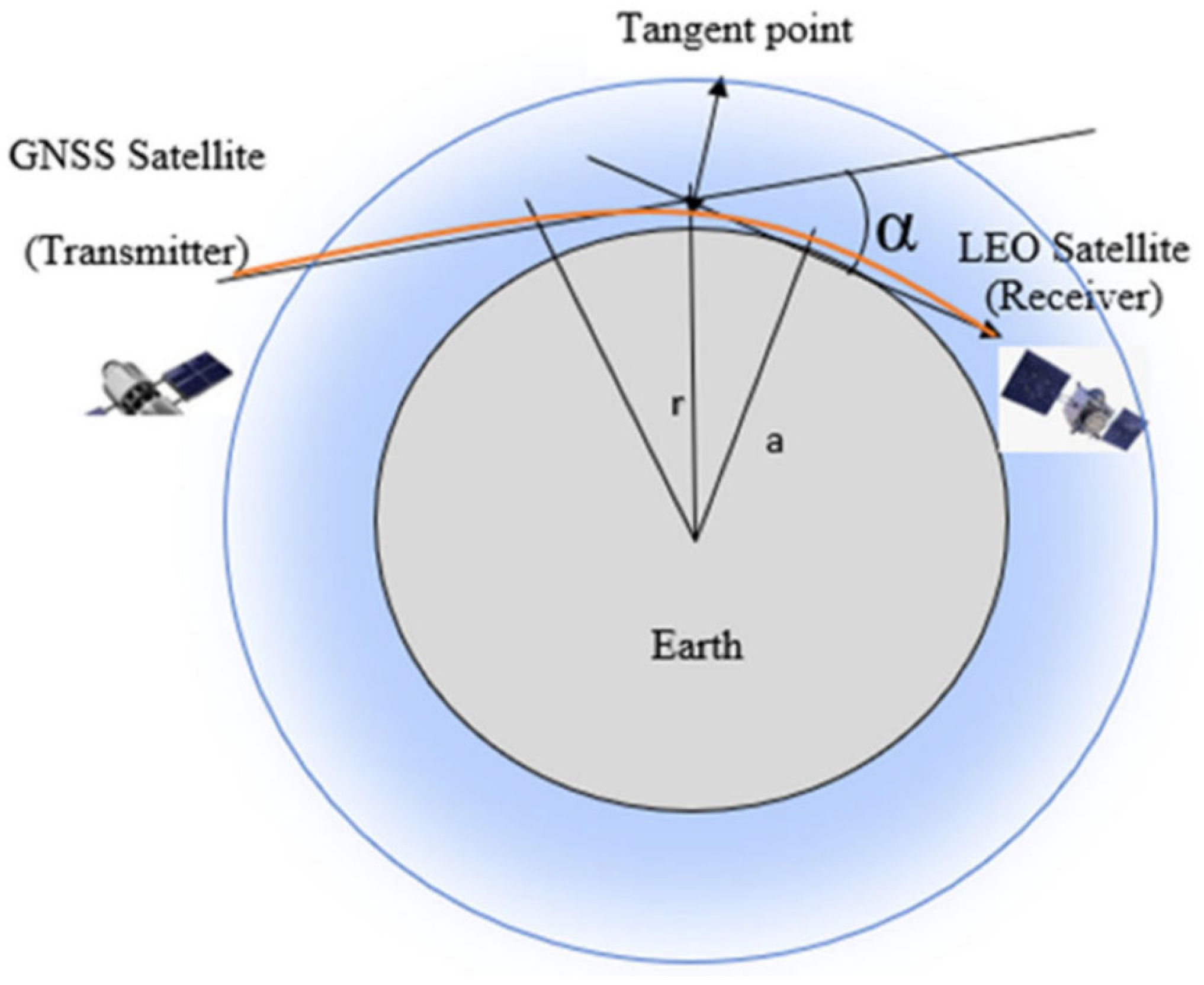
3.1. GNSS-RO
3.2. PPP
3.3. CORS
3.4. GNSS-R and GNSS-IR
4. Climate Monitoring
4.1. Atmosphere
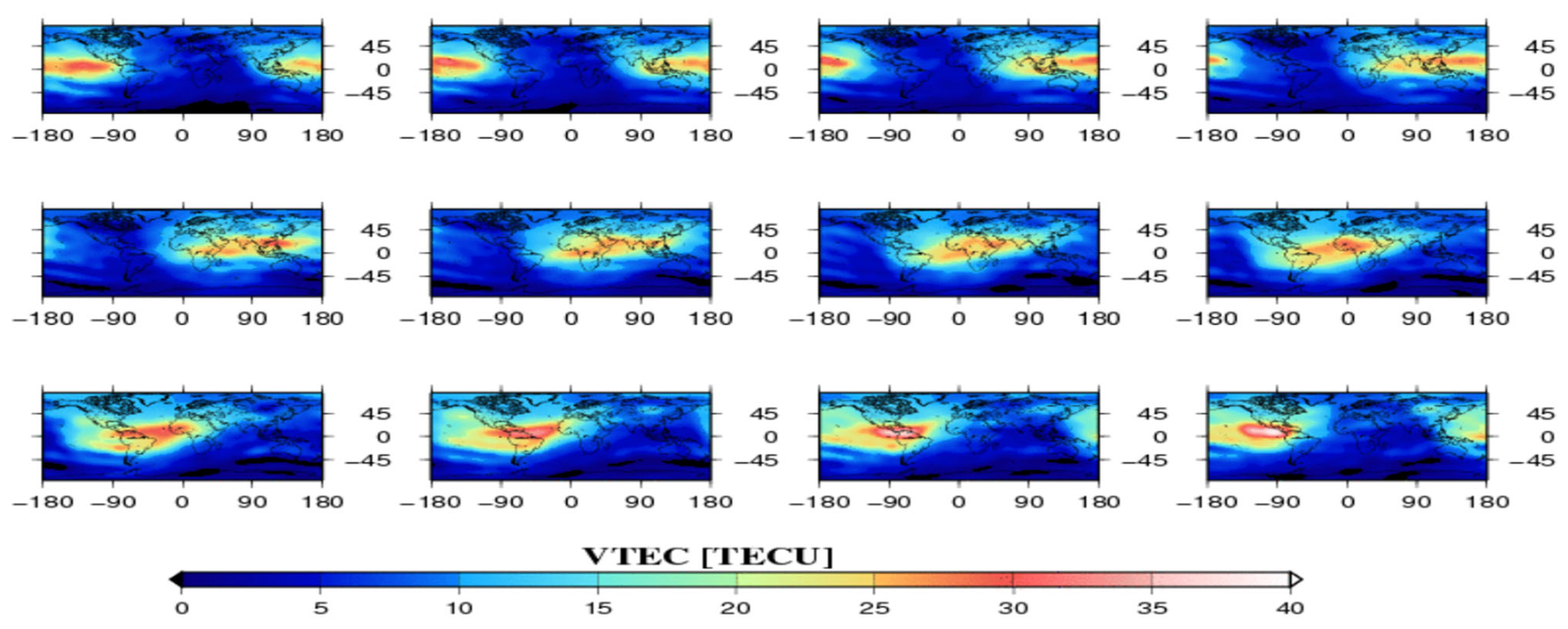
4.1.1. Ionosphere
4.1.2. Troposphere
4.1.3. Weather Events
4.2. Cryosphere
4.2.1. Sea Ice
4.2.2. Snow
4.2.3. Glaciers
4.2.4. Permafrost
4.3. Hydrosphere
4.3.1. Inland Water
4.3.2. Groundwater
4.3.3. Hydrological Phenomena
4.4. Oceans and Seas
4.4.1. Sea Level
4.4.2. Surface Dynamics
4.4.3. Coasts
4.5. Geodynamics
4.6. Biosphere
5. Knowledge Gaps and Future Directions
- Standardization of higher-order ionospheric corrections and horizontal gradients in climate time series.
- Separation of the effects of dielectric permittivity from surface roughness in GNSS-R measurements of snow and permafrost.
- Rigorous physical separation of local anthropogenic subsidence from regional mass loads induced by climate change.
- Development of AI models incorporating the laws of physics into early warning and weather forecasting systems.
6. Conclusions
Author Contributions
Funding
Data Availability Statement
Conflicts of Interest
Appendix A

| GNSS Technique | Main Climate/Environmental Applications | Measured/Derived Parameters | Spatial Resolution | Temporal Resolution | Typical Accuracy | Computational Requirements | Infrastructure/Cost | Main Advantages | Main Limitations |
|---|---|---|---|---|---|---|---|---|---|
| GNSS-RO | Atmosphere, climate monitoring, weather forecasting | Temperature, pressure, humidity, refractivity | Global | ~100 m | High | Medium/High | High cost of LEO platform; low cost per individual observation | Global coverage, long-term stability, independence from clouds | Limited horizontal resolution; dependence on occultation geometry |
| PPP | Deformation monitoring, hydrosphere, glaciers, troposphere | Coordinates, ZTD/PWV | Local (point-based) | Seconds–days | mm–cm | Medium | Medium | High accuracy, no reference station required | Requires precise satellite orbits and clocks; convergence time |
| CORS | Deformation monitoring, atmosphere, hydrology | Coordinates, ZTD/PWV, TEC | Regional | Continuous, high frequency | mm–cm | Medium | High infrastructure cost | Continuous observations, high accuracy, multiple applications | Network maintenance costs; dependence on station density |
| GNSS-R | Oceans, ice, soil moisture, floods | Soil moisture, water level, wind speed, wave height | Regional/global, depending on platform (ground/satellite) | High | method-dependent (ground, satellite) | High | Medium/High | Large spatial coverage, uses existing GNSS signals | Complex processing; dependence on surface properties |
| GNSS-IR | Snow, water level, soil, coastal areas | Snow depth, water level, soil moisture | Point-based/local | Very high | cm–dm, application-dependent | Low/Medium | Low | Can use existing GNSS antennas; low cost | Limited spatial representativeness; dependence on reflection geometry |
References
- Maciuk, K. Different Approaches in GLONASS Orbit Computation from Broadcast Ephemeris. Geod. Vestn. 2016, 60, 455–466. [Google Scholar] [CrossRef] [Scilit]
- Maciuk, K.; Lewińska, P. High-Rate Monitoring of Satellite Clocks Using Two Methods of Averaging Time. Remote Sens. 2019, 11, 2754. [Google Scholar] [CrossRef] [Scilit]
- Maciuk, K. Satellite Clock Stability Analysis Depending on the Reference Clock Type. Arab. J. Geosci. 2019, 12, 28. [Google Scholar] [CrossRef] [Scilit]
- Abdelazeem, M.; Abazeed, A.; Alsultan, A.; Wahaballa, A.M. Assessment of Affordable Real-Time PPP Solutions for Transportation Applications. Algorithms 2025, 18, 390. [Google Scholar] [CrossRef] [Scilit]
- Noor, A. Climate Change Adaptation and Mitigation in Cities. Urban Clim. Adapt. Mitig. 2022, 23–47. [Google Scholar] [CrossRef] [Scilit]
- Connell, R. Five Health Concerns. In Urban Climate Change Crossroads; Taylor and Francis: Oxfordshire, UK, 2017; pp. 49–56. [Google Scholar]
- Stroeve, J.; Notz, D. Changing State of Arctic Sea Ice across All Seasons. Environ. Res. Lett. 2018, 13, 103001. [Google Scholar] [CrossRef] [Scilit]
- Church, J.A.; White, N.J. Sea-Level Rise from the Late 19th to the Early 21st Century. Surv. Geophys. 2011, 32, 585–602. [Google Scholar] [CrossRef] [Scilit]
- Zhang, Z.; Gao, F.; Xu, T.; Li, S.; Qin, J.; Wang, N. Evaluation of COSMIC-2 Performance in Detecting Atmospheric Boundary Layer Height and Analysis of Its Variation. Meas. Sci. Technol. 2023, 34, 125803. [Google Scholar] [CrossRef] [Scilit]
- Swafiyudeen, B.; Sa’i, U.I.; Bala, A.; Abubakar, A.Z.; Musa, A.A.; Shehu, N. Modeling Precipitable Water Vapour (PWV) Over Nigeria from Ground-Based GNSS. Geoplanning 2021, 8, 41–50. [Google Scholar] [CrossRef] [Scilit]
- Xu, T.; Wang, N.; He, Y.; Li, Y.; Meng, X.; Gao, F.; Lopez-Baeza, E. GNSS Reflectometry-Based Ocean Altimetry: State of the Art and Future Trends. Remote Sens. 2024, 16, 1754. [Google Scholar] [CrossRef] [Scilit]
- Anthes, R.A.; Bernhardt, P.A.; Chen, Y.; Cucurull, L.; Dymond, K.F.; Ector, D.; Healy, S.B.; Ho, S.-P.; Hunt, D.C.; Kuo, Y.-H.; et al. The COSMIC/FORMOSAT-3 Mission: Early Results. Bull. Am. Meteorol. Soc. 2008, 89, 313–334. [Google Scholar] [CrossRef] [Scilit]
- Jin, S.; Feng, G.P.; Gleason, S. Remote Sensing Using GNSS Signals: Current Status and Future Directions. Adv. Space Res. 2011, 47, 1645–1653. [Google Scholar] [CrossRef] [Scilit]
- Petrescu, L.; Antonescu, B.; Nistor, S.; Floroiu, I.; Ene, D.; Ghica, D.; Ionescu, C.; Anghel, A.; Datcu, M. Seismo-Acoustic and GNSS Observations of a Record-Breaking Black Sea Storm: Repurposing Geophysical Sensors for Environmental Monitoring. Nat. Hazards Earth Syst. Sci. 2026, 26, 2227–2247. [Google Scholar] [CrossRef] [Scilit]
- Bock, Y.; Melgar, D. Physical Applications of GPS Geodesy: A Review. Rep. Prog. Phys. 2016, 79, 106801. [Google Scholar] [CrossRef] [Scilit]
- Dawidowicz, K. Differences in GPS Coordinate Time Series Resulting from the Use of Individual Instead of Type-Mean Antenna Phase Center Calibration Model. Stud. Geophys. Geod. 2018, 62, 38–56. [Google Scholar] [CrossRef] [Scilit]
- Tsai, L.C.; Chien, H.; Su, S.Y.; Liu, C.H.; Schuh, H.; Alizadeh, M.M.; Wickert, J. Ocean-Surface Wave Measurements Using Scintillation Theories on Seaborne Software-Defined GPS and SBAS Reflectometry Observations. Sensors 2023, 23, 6185. [Google Scholar] [CrossRef] [Scilit]
- Sievert, T.; Rasch, J.; Carlström, A.; Ingemar Pettersson, M. Analysis of Reflections in GNSS Radio Occultation Measurements Using the Phase Matching Amplitude. Atmos. Meas. Tech. 2018, 11, 569–580. [Google Scholar] [CrossRef] [Scilit]
- Dawidowicz, K.; Krzan, G.; Wielgosz, P. Offsets in the EPN Station Position Time Series Resulting from Antenna/Radome Changes: PCC Type-Dependent Model Analyses. GPS Solut. 2023, 27, 9. [Google Scholar] [CrossRef] [Scilit]
- Aparicio, J.M.; Cardellach, E.; Rodríguez, H. Information Content in Reflected Signals during GPS Radio Occultation Observations. Atmos. Meas. Tech. 2018, 11, 1883–1900. [Google Scholar] [CrossRef] [Scilit]
- Titus, M.L.; Thompson, K.R.; Oliver, E.C.J.; Klotzbach, P.J. Statistical Reconstruction of Seasonal Tropical Cyclone Variability in the North Atlantic Basin. J. Geophys. Res. Atmos. 2021, 126, e2020JD032669. [Google Scholar] [CrossRef] [Scilit]
- Sa’i Ibrahim, U.; Aleem, K.; Musa, T.A.; Youngu, T.T.; Obadaki, Y.Y.; Anom, W.; Aris, W.; Tang, K.; Wee, K. An Investigation of GNSS Radio Occultation Data Pattern for Temperature Monitoring and Analysis over Africa. NDT 2025, 3, 15. [Google Scholar] [CrossRef] [Scilit]
- Hadas, T.; Teferle, F.N.; Kazmierski, K.; Hordyniec, P.; Bosy, J. Optimum Stochastic Modeling for GNSS Tropospheric Delay Estimation in Real-Time. GPS Solut. 2017, 21, 1069–1081. [Google Scholar] [CrossRef] [Scilit]
- Zhu, G.; Huang, L.; Yang, Y.; Li, J.; Zhou, L.; Liu, L. Refining the ERA5-Based Global Model for Vertical Adjustment of Zenith Tropospheric Delay. Satell. Navig. 2022, 3, 27. [Google Scholar] [CrossRef] [Scilit]
- Tayfehrostami, A.; Amerian, Y. Analysis of Tropospheric Precipitable Water Vapor Variations Using GNSS Radio Occultation Data and Radiosonde Observations (Case Study: Iran). J. Earth Space Phys. 2025, 51, 499–516. [Google Scholar] [CrossRef]
- Jin, S.; Komjathy, A. GNSS Reflectometry and Remote Sensing: New Objectives and Results. Adv. Space Res. 2010, 46, 111–117. [Google Scholar] [CrossRef] [Scilit]
- Li, Y.; Yuan, Y.; Song, M. Using GNSS Radio Occultation Data to Monitor Tropical Atmospheric Anomalies during the January–February 2009 Sudden Stratospheric Warming Event. Remote Sens. 2022, 14, 3234. [Google Scholar] [CrossRef] [Scilit]
- Zhran, M.; Mousa, A. Global Tropopause Height Determination Using GNSS Radio Occultation. Egypt. J. Remote Sens. Space Sci. 2023, 26, 317–331. [Google Scholar] [CrossRef] [Scilit]
- Mo, Z.; Lou, Y.; Zhang, W.; Zhou, Y.; Wu, P.; Zhang, Z. Performance Assessment of Multi-Source GNSS Radio Occultation from COSMIC-2, MetOp-B/C, FY-3D/E, Spire and PlanetiQ over China. Atmos. Res. 2024, 311, 107704. [Google Scholar] [CrossRef] [Scilit]
- Bowler, N.E.; Lewis, O. Experiments with a Large Number of GNSS-RO Observations through the ROMEX Collaboration in the Met Office NWP System. Atmos. Meas. Tech. 2026, 19, 2479–2505. [Google Scholar] [CrossRef] [Scilit]
- Liu, C.; Sun, Y.; Bai, W.; Du, Q.; Li, W.; Wang, X.; Li, P. Effect of Multiple GNSS Integration on the Number and Spatiotemporal Coverage of Radio Occultation Events. Atmosphere 2022, 13, 654. [Google Scholar] [CrossRef] [Scilit]
- Rahimi, B.; Foelsche, U. The Potential of Observing Atmospheric Rivers with Global Navigation Satellite System (GNSS) Radio Occultation. Atmos. Meas. Tech. 2025, 18, 2481–2507. [Google Scholar] [CrossRef] [Scilit]
- Heßelbarth, A. GNSS Analysis by Means of Precise Point Positioning (PPP)[GNSS-Auswertung Mittels Precise Point Positioning (PPP)]. ZFV-Z. Geodasie Geoinf. Landmanag. 2009, 134, 278–286. [Google Scholar]
- Hadas, T.; Hobiger, T.; Hordyniec, P. Considering Different Recent Advancements in GNSS on Real-Time Zenith Troposphere Estimates. GPS Solut. 2020, 24, 99. [Google Scholar] [CrossRef] [Scilit]
- Huang, L.; Jiang, W.; Liu, L.; Chen, H.; Ye, S. A New Global Grid Model for the Determination of Atmospheric Weighted Mean Temperature in GPS Precipitable Water Vapor. J. Geod. 2019, 93, 159–176. [Google Scholar] [CrossRef] [Scilit]
- Zumberge, J.F.; Heflin, M.B.; Jefferson, D.C.; Watkins, M.M.; Webb, F.H. Precise Point Positioning for the Efficient and Robust Analysis of GPS Data from Large Networks. J. Geophys. Res. Solid Earth 1997, 102, 5005–5017. [Google Scholar] [CrossRef] [Scilit]
- Cvetkov, V. Evaluating Levelling Adjustment Methods in Deformation Analysis. Bud. Archit./Civ. Archit. Eng. 2026, 25, 1–12. [Google Scholar] [CrossRef] [Scilit]
- Jiang, Y.; Gao, Y.; Zhou, P.; Gao, Y.; Huang, G. Real-Time Cascading PPP-WAR Based on Kalman Filter Considering Time-Correlation. J. Geod. 2021, 95, 69. [Google Scholar] [CrossRef] [Scilit]
- Naumowicz, B.; Kowalczyk, K.; Pelc-Mieczkowska, R. PPP Solution-Based Model of Absolute Vertical Movements of the Earth’s Crust in Poland With Consideration of Geological, Tectonic, Hydrological and Mineral Information. Earth Space Sci. 2024, 11, e2023EA003268. [Google Scholar] [CrossRef] [Scilit]
- Ma, D.; Jia, Y.; Cheng, B.; Wang, Y.; Li, M. Assessing Subsidence in Remote Reclaimed Islands by Integrating PPP, Leveling, and InSAR. Remote Sens. 2025, 17, 3628. [Google Scholar] [CrossRef] [Scilit]
- Zhang, G.; Han, S.; Ye, J.; Hao, R.; Zhang, J.; Li, X.; Jia, K. A Method for Precisely Predicting Satellite Clock Bias Based on Robust Fitting of ARMA Models. GPS Solut. 2022, 26, 3. [Google Scholar] [CrossRef] [Scilit]
- Zhao, L.; Blunt, P.; Yang, L. Performance Analysis of Zero-Difference GPS L1/L2/L5 and Galileo E1/E5a/E5b/E6 Point Positioning Using CNES Uncombined Bias Products. Remote Sens. 2022, 14, 650. [Google Scholar] [CrossRef] [Scilit]
- Van Nguyen, H.; Pham, K.C.; Nguyen, D.B.; Nguyen, L.Q. Application of the GNSS Method in the Monitoring of Mine Surface Displacement: A Systemic Review. Inz. Miner. 2024, 53, 247–255. [Google Scholar] [CrossRef] [Scilit]
- Li, P.; Chen, S.; Hu, J.; Xie, X.; Dai, J.; Shu, B.; Huang, G. A New Strategy for Improving Multi-Frequency PPP-RTK Ionospheric Correction Availability and User Performance in Low- and Middle-Latitudes. J. Geophys. Res. Space Phys. 2026, 131, e2026JA035522. [Google Scholar] [CrossRef] [Scilit]
- Dawidowicz, K. Comparison of Using Relative and Absolute PCV Corrections in Short Baseline GNSS Observation Processing. Artif. Satell. 2011, 46, 19–31. [Google Scholar] [CrossRef] [Scilit]
- Snay, R.A.; Soler, T. Continuously Operating Reference Station (CORS): History, Applications, and Future Enhancements. J. Surv. Eng. 2008, 134, 95–104. [Google Scholar] [CrossRef] [Scilit]
- Sukhenko, A.; Meirambekuly, N.; Syzdykov, A.; Mukhamedgali, A.; Mellatova, Y. GNSS for High-Precision and Reliable Positioning: A Review of Correction Techniques and System Architectures. Appl. Sci. 2025, 15, 12304. [Google Scholar] [CrossRef] [Scilit]
- Berg, D.L.; Adhikari, S.; Hassan, J.; Steffen, R.; Steffen, H.; Willis, M.; Khan, S.A. Estimation and Attribution of Horizontal Land Motion Measured by the Greenland GNSS Network. J. Geophys. Res. Solid Earth 2025, 130, e2024JB030847. [Google Scholar] [CrossRef] [Scilit]
- Lenzano, M.G.; Rivera, A.; Durand, M.; Vacaflor, P.; Carbonetti, M.; Lannutti, E.; Gende, M.; Lenzano, L. Detection of Crustal Uplift Deformation in Response to Glacier Wastage in Southern Patagonia. Remote Sens. 2023, 15, 584. [Google Scholar] [CrossRef] [Scilit]
- Tretyak, K.; Brusak, I.; Babchenko, V. Recent Deformations of the Earth’s Crust in Ukraine Based on Gnss Network Data from Geoterrace and System. Net. Geodyn. 2024, 37, 56–68. [Google Scholar] [CrossRef] [Scilit]
- Tabar, M.E.; Sisman, Y. Deep Learning-Based Modeling and Prediction of GNSS Time Series: A Comparative Analysis of Adaptive Optimization Algorithms. Adv. Space Res. 2025, 76, 2086–2103. [Google Scholar] [CrossRef] [Scilit]
- Yang, Y.; Xu, C.; Yang, Q.; Xu, X.; Huang, Y.; Dong, H. Application and Technological Evolution of GNSS in Natural Hazard Research: A Comprehensive Analysis Based on a Hybrid Review Approach. Remote Sens. 2026, 18, 887. [Google Scholar] [CrossRef] [Scilit]
- Pipitone, C.; Maltese, A.; Lo Brutto, M.; Dardanelli, G. A Review of Selected Applications of GNSS CORS and Related Experiences at the University of Palermo (Italy). Remote Sens. 2023, 15, 5343. [Google Scholar] [CrossRef] [Scilit]
- White, A.M.; Lajoie, L.J.; Knappe, E.; Martens, H.R.; Swarr, M.J.; Khatiwada, A.; Oliver, B.; Perry, M.; Clayton, N.; Bendick, R.; et al. High-Density Integrated GNSS and Hydrologic Monitoring Network for Short-Scale Hydrogeodesy in High Mountain Watersheds. Earth Space Sci. 2023, 10, e2022EA002678. [Google Scholar] [CrossRef] [Scilit]
- Jin, S.; Wang, Q.; Dardanelli, G. A Review on Multi-GNSS for Earth Observation and Emerging Applications. Remote Sens. 2022, 14, 3930. [Google Scholar] [CrossRef] [Scilit]
- Abdelhamid, M. GNSS Interferometric Reflectometry as a Passive Remote Sensing Method for Studying Environmental Phenomena. J. Appl. Geod. 2025, 20, 1–11. [Google Scholar] [CrossRef] [Scilit]
- Cardellach, E.; Fabra, F.; Nogués-Correig, O.; Oliveras, S.; Ribó, S.; Rius, A. GNSS-R Ground-Based and Airborne Campaigns for Ocean, Land, Ice, and Snow Techniques: Application to the GOLD-RTR Data Sets. Radio Sci. 2011, 46, 1–16. [Google Scholar] [CrossRef] [Scilit]
- Wang, X.; Zhang, S.; Wang, L.; He, X.; Zhang, Q. Analysis and Combination of Multi-GNSS Snow Depth Retrievals in Multipath Reflectometry. GPS Solut. 2020, 24, 77. [Google Scholar] [CrossRef] [Scilit]
- Zhao, D.; Heidler, K.; Asgarimehr, M.; Albrecht, C.M.; Wickert, J.; Zhu, X.X.; Mou, L. Multimodal GNSS-R Self-Supervised Learning as a Generalist Earth Surface Monitor. Int. J. Appl. Earth Obs. Geoinf. 2025, 142, 104658. [Google Scholar] [CrossRef] [Scilit]
- Song, M.; Wang, X.; He, Z.; Jia, D.; Xiao, R.; He, X. Two Decades of GNSS-IR Observations Reveal an Asymmetric Decline in Coastal Sea Ice Phenology of the Beaufort Sea. EGUsphere 2026, 2026, 1–27. [Google Scholar] [CrossRef] [Scilit]
- Dahl-Jensen, T.S.; Andersen, O.B.; Williams, S.D.P.; Helm, V.; Khan, S.A. Gnss-Ir Measurements of Inter Annual Sea Level Variations in Thule, Greenland from 2008–2019. Remote Sens. 2021, 13, 5077. [Google Scholar] [CrossRef] [Scilit]
- Camps, A.; Rodriguez-Alvarez, N.; Valencia, E.; Forte, G.; Ramos, I.; Alonso-Arroyo, A.; Bosch-Lluis, X. Land Monitoring Using GNSS-R Techniques: A Review of Recent Advances. In Proceedings of the 2013 IEEE International Geoscience and Remote Sensing Symposium, Melbourne, Australia, 21–26 July 2013; pp. 4026–4029. [Google Scholar] [CrossRef] [Scilit]
- Re, U.G. Monitoring of SoIl MoiSture and WateR-Ooded Areas for AgricuLture and Environment; European Commission: Bruxelles, Belgium, 2018. [Google Scholar] [CrossRef]
- Zhang, R.; Liu, K.; Wang, X.; Li, Z.; Xie, T.; Chen, Q.; Chang, X. Assessing the Performance of GNSS-IR for Sea Level Monitoring During Hurricane-Induced Storm Surges. Remote Sens. 2025, 17, 3132. [Google Scholar] [CrossRef] [Scilit]
- Ha, M.C.; Darrozes, J.; Llubes, M.; Grippa, M.; Ramillien, G.; Frappart, F.; Baup, F.; Tagesson, H.T.; Mougin, E.; Guiro, I.; et al. GNSS-R Monitoring of Soil Moisture Dynamics in Areas of Severe Drought: Example of Dahra in the Sahelian Climatic Zone (Senegal). Eur. J. Remote Sens. 2023, 56, 2156931. [Google Scholar] [CrossRef] [Scilit]
- Beşel Hatipoğlu, C.; Tanır Kayıkçı, E. Quality Control of the GNSS-IR Sea Level Measurements by Using K-Means Clustering. Surv. Rev. 2025, 57, 438–451. [Google Scholar] [CrossRef] [Scilit]
- Bu, J.; Wang, Q.; Wang, Z.; Fan, S.; Liu, X.; Zuo, X. Land Remote Sensing Applications Using Spaceborne GNSS Reflectometry: A Comprehensive Overview; IEEE: New York, NY, USA, 2024; Volume 17. [Google Scholar]
- Yang, Y.; Hu, Y. Inland Water Body Detection Using GNSS-R Observations from FY-3 Satellites. Appl. Sci. 2026, 16, 3374. [Google Scholar] [CrossRef] [Scilit]
- Yang, C.; Mao, K.; Guo, Z.; Shi, J.; Bateni, S.M.; Yuan, Z. Review of GNSS-R Technology for Soil Moisture Inversion. Remote Sens. 2024, 16, 1193. [Google Scholar] [CrossRef] [Scilit]
- Huang, L.; Pan, A.; Chen, F.; Guo, F.; Li, H.; Liu, L. A Novel Global Grid Model for Soil Moisture Retrieval Considering Geographical Disparity in Spaceborne GNSS-R. Satell. Navig. 2024, 5, 29. [Google Scholar] [CrossRef] [Scilit]
- Yan, Q.; Huang, W. Sea Ice Remote Sensing Using GNSS-R: A Review. Remote Sens. 2019, 11, 2565. [Google Scholar] [CrossRef] [Scilit]
- Hu, Y.; Hua, X.; Yan, Q.; Liu, W.; Jiang, Z.; Wickert, J. Sea Ice Detection from GNSS-R Data Based on Local Linear Embedding. Remote Sens. 2024, 16, 2621. [Google Scholar] [CrossRef] [Scilit]
- Wan, W.; Guo, Z.; Karegar, M.A.; Tang, G.; Larson, K.M. GNSS Hydrology: Defining a New Interdiscipline Integrating GNSS Hydrogeodesy and Remote Sensing. Innovation 2025, 6, 100990. [Google Scholar] [CrossRef] [Scilit]
- Bu, J.; Li, H.; Yu, K.; Huang, W.; Wang, Q.; Ji, C.; Wang, Q.; Wang, Z.; He, M.; Fan, S.; et al. Machine Learning Methods for Earth Observation and Remote Sensing Using Spaceborne GNSS Reflectometry: Current Status, Challenges, and Future Prospects. IEEE Geosci. Remote Sens. Mag. 2025, 13, 8–71. [Google Scholar] [CrossRef] [Scilit]
- Kursinski, E.R.; Hajj, G.A.; Schofield, J.T.; Linfield, R.P.; Hardy, K.R. Observing Earth’s Atmosphere with Radio Occultation Measurements Using the Global Positioning System. J. Geophys. Res. Atmos. 1997, 102, 23429–23465. [Google Scholar] [CrossRef] [Scilit]
- Ma, X.; Zhao, Q.; Yao, Y.; Yao, W. A Novel Method of Retrieving Potential ET in China. J. Hydrol. 2021, 598, 126271. [Google Scholar] [CrossRef] [Scilit]
- Mohammed, W.M.; Kallow, S.M.; Jawad, D.W.H.; Kabrch, J.K.; Salman, K.; Amini, A. Integrating Geodetic Technology with Legal Governance for Global Monitoring of Water and Soil Dynamics: Kalman Filter and Inverse Modeling Approaches. Water Soil Manag. Model. 2025, 5, 28–40. [Google Scholar] [CrossRef]
- Vaquero-Martínez, J.; Antón, M. Review on the Role of Gnss Meteorology in Monitoring Water Vapor for Atmospheric Physics. Remote Sens. 2021, 13, 2287. [Google Scholar] [CrossRef] [Scilit]
- Li, X.; Dick, G.; Lu, C.; Ge, M.; Nilsson, T.; Ning, T.; Wickert, J.; Schuh, H. Multi-GNSS Meteorology: Real-Time Retrieving of Atmospheric Water Vapor from BeiDou, Galileo, GLONASS, and GPS Observations. IEEE Trans. Geosci. Remote Sens. 2015, 53, 6385–6393. [Google Scholar] [CrossRef] [Scilit]
- Rohm, W.; Yuan, Y.; Biadeglgne, B.; Zhang, K.; Marshall, J. Le Ground-Based GNSS ZTD/IWV Estimation System for Numerical Weather Prediction in Challenging Weather Conditions. Atmos. Res. 2014, 138, 414–426. [Google Scholar] [CrossRef] [Scilit]
- Kong, J.; Yao, Y.; Xu, Y.; Kuo, C.; Zhang, L.; Liu, L.; Zhai, C. A Clear Link Connecting the Troposphere and Ionosphere: Ionospheric Reponses to the 2015 Typhoon Dujuan. J. Geod. 2017, 91, 1087–1097. [Google Scholar] [CrossRef] [Scilit]
- Gouveia, T.A.F.; Galera Monico, J.F.; Alves, D.B.M.; Sapucci, L.F.; Geremia-Nievinski, F. 50 Years of Synergy between Space Geodesy and Meteorology: From a GNSS Positioning Error to Precipitation Nowcasting Applications. Rev. Bras. Cartogr. 2020, 72, 1509–1535. [Google Scholar] [CrossRef] [Scilit]
- Todorova, S. Integration of Altimetry Measurements in Globarl Ionosphere Maps from GNSS Data. In Proceedings of the 9th Professional Conference of Postgraduate Students JUNIORSTAV 2007, Brno, Czech Republic, 21 January 2007. [Google Scholar]
- Zhang, S.R.; Vierinen, J.; Aa, E.; Goncharenko, L.P.; Erickson, P.J.; Rideout, W.; Coster, A.J.; Spicher, A. 2022 Tonga Volcanic Eruption Induced Global Propagation of Ionospheric Disturbances via Lamb Waves. Front. Astron. Space Sci. 2022, 9, 871275. [Google Scholar] [CrossRef] [Scilit]
- Ding, M. A Neural Network Model for Predicting Weighted Mean Temperature. J. Geod. 2018, 92, 1187–1198. [Google Scholar] [CrossRef] [Scilit]
- Yao, Y.; Hu, Y.; Yu, C.; Zhang, B.; Guo, J. An Improved Global Zenith Tropospheric Delay Model GZTD2 Considering Diurnal Variations. Nonlinear Process. Geophys. 2016, 23, 127–136. [Google Scholar] [CrossRef] [Scilit]
- Ghaffari Razin, M.R. Efficiency of the Adaptive Neuro-Fuzzy Inference System in Tropospheric Slant Water Vapor Modeling. J. Earth Space Phys. 2021, 47, 257–273. [Google Scholar] [CrossRef] [Scilit]
- Braga, F.L.S.; Dal Poz, W.R. Effects of Tropospheric Refraction on Precise Point Positioning in Brazil. Pesqui. Geocienc. 2022, 49, e118014. [Google Scholar] [CrossRef] [Scilit]
- Huang, L.; Liu, L.; Chen, H.; Jiang, W. An Improved Atmospheric Weighted Mean Temperature Model and Its Impact on GNSS Precipitable Water Vapor Estimates for China. GPS Solut. 2019, 23, 51. [Google Scholar] [CrossRef] [Scilit]
- Hein, G.W. Status, Perspectives and Trends of Satellite Navigation. Satell. Navig. 2020, 1, 22. [Google Scholar] [CrossRef] [Scilit]
- Ma, Y.; Chen, P.; Liu, H.; Ruan, Q. Establishment of Regional Tropospheric Delay Model in Australia; Springer: Singapore, 2019; Volume 562. [Google Scholar]
- Hernández-Pajares, M.; Miguel, J.; Jaume Sanz, J.; Aragón-Àngel, À.; García-Rigo, A.; Salazar, D.; Escudero, M.; Hernández-Pajares, M.; Juan, J.M.; Sanz, J.; et al. The Ionosphere: Effects, GPS Modeling and the Benefits for Space Geodetic Techniques. J. Geod. 2011, 85, 887–907. [Google Scholar] [CrossRef] [Scilit]
- Xing, H.; Jin, S. Structure and Variations of Global Planetary Boundary Layer Top from 2008-2022 Multiple GNSS RO Observations. J. Atmos. Sol.-Terr. Phys. 2023, 252, 106155. [Google Scholar] [CrossRef] [Scilit]
- Yuan, Y.; Li, Z.; Wang, N.; Zhang, B.; Li, H.; Li, M.; Huo, X.; Ou, J. Monitoring the Ionosphere Based on the Crustal Movement Observation Network of China. Geod. Geodyn. 2015, 6, 73–80. [Google Scholar] [CrossRef] [Scilit]
- Bai, W.; Liu, C.; Meng, X.; Sun, Y.; Kirchengast, G.; Du, Q.; Wang, X.; Yang, G.; Liao, M.; Yang, Z.; et al. Evaluation of Atmospheric Profiles Derived from Single- and Zero-Difference Excess Phase Processing of BeiDou Radio Occultation Data from the FY-3C GNOS Mission. Atmos. Meas. Tech. 2018, 11, 819–833. [Google Scholar] [CrossRef] [Scilit]
- Xia, P.; Ye, S.; Xu, C.; Jiang, W. Establishing a High-Precision ZHD Model of China Using 8 Years of Radiosonde Data. J. Atmos. Ocean. Technol. 2021, 38, 1173–1186. [Google Scholar] [CrossRef] [Scilit]
- Huang, L.; Zhu, G.; Liu, L.; Chen, H.; Jiang, W. A Global Grid Model for the Correction of the Vertical Zenith Total Delay Based on a Sliding Window Algorithm. GPS Solut. 2021, 25, 98. [Google Scholar] [CrossRef] [Scilit]
- Scaramuzza, S.; Dach, R.; Beutler, G.; Arnold, D.; Sušnik, A.; Jäggi, A. Dependency of Geodynamic Parameters on the GNSS Constellation. J. Geod. 2018, 92, 93–104. [Google Scholar] [CrossRef] [Scilit]
- Zhao, L.; Václavovic, P.; Douša, J. Performance Evaluation of Troposphere Estimated from Galileo-Only Multi-Frequency Observations. Remote Sens. 2020, 12, 373. [Google Scholar] [CrossRef] [Scilit]
- Li, Z.; Chen, W.; van Dam, T.; Rebischung, P.; Altamimi, Z. Comparative Analysis of Different Atmospheric Surface Pressure Models and Their Impacts on Daily ITRF2014 GNSS Residual Time Series. J. Geod. 2020, 94, 42. [Google Scholar] [CrossRef] [Scilit]
- Jin, S.; Luo, O.F. Variability and Climatology of PWV from Global 13-Year GPS Observations. IEEE Trans. Geosci. Remote Sens. 2009, 47, 1918–1924. [Google Scholar] [CrossRef]
- Sam-Khaniani, A.; Safari, A.; Hedayati, M.; Hossien-Zadeh, M.R. Validation and Calibration of COSMIC-2 Derived Precipitable Water Vapor Utilizing Radiosonde Observations across Iran. Adv. Space Res. 2026, 78, 2274–2294. [Google Scholar] [CrossRef] [Scilit]
- Guerova, G.; Jones, J.; Douša, J.; Dick, G.; De Haan, S.; Pottiaux, E.; Bock, O.; Pacione, R.; Elgered, G.; Vedel, H.; et al. Review of the State of the Art and Future Prospects of the Ground-Based GNSS Meteorology in Europe. Atmos. Meas. Tech. 2016, 9, 5385–5406. [Google Scholar] [CrossRef] [Scilit]
- Wang, J.; Dai, A.; Mears, C.; Wang, J.; Dai, A.; Mears, C. Global Water Vapor Trend from 1988 to 2011 and Its Diurnal Asymmetry Based on GPS, Radiosonde, and Microwave Satellite Measurements. J. Clim. 2016, 29, 5205–5222. [Google Scholar] [CrossRef] [Scilit]
- Benevides, P.; Catalao, J.; Miranda, P.M.A. On the Inclusion of GPS Precipitable Water Vapour in the Nowcasting of Rainfall. Nat. Hazards Earth Syst. Sci. 2015, 15, 2605–2616. [Google Scholar] [CrossRef] [Scilit]
- Manandhar, S.; Lee, Y.H.; Meng, Y.S.; Yuan, F.; Ong, J.T. GPS-Derived PWV for Rainfall Nowcasting in Tropical Region. IEEE Trans. Geosci. Remote Sens. 2018, 56, 4835–4844. [Google Scholar] [CrossRef] [Scilit]
- Yan, X.; Ducrocq, V.; Poli, P.; Hakam, M.; Jaubert, G.; Walpersdorf, A. Impact of GPS Zenith Delay Assimilation on Convective-Scale Prediction of Mediterranean Heavy Rainfall. J. Geophys. Res. Atmos. 2009, 114, 3104. [Google Scholar] [CrossRef] [Scilit]
- Jones, J.; Guerova, G.; Douša, J.; Dick, G.; de Haan, S.; Pottiaux, E.; Bock, O.; Pacione, R.; van Malderen, R. (Eds.) Advanced GNSS Tropospheric Products for Monitoring Severe Weather Events and Climate; Springer: Berlin/Heidelberg, Germany, 2020. [Google Scholar]
- Cegla, A.; Moeller, G.; Rohm, W.; Kryza, M.; Taszarek, M. Application of Integrated GNSS Tomography in Observation Study over the Area of Southern Poland. Adv. Space Res. 2024, 74, 3654–3667. [Google Scholar] [CrossRef] [Scilit]
- Profetto, L.; Antonini, A.; Fibbi, L.; Ortolani, A.; Dimitri, G.M. A Two-Step Machine Learning Approach Integrating GNSS-Derived PWV for Improved Precipitation Forecasting. Entropy 2025, 27, 1034. [Google Scholar] [CrossRef] [Scilit]
- Yin, W.; Zhou, C.; Tian, Y.; Qiu, H.; Zhang, W.; Chen, H.; Liu, P.; Zhao, Q.; Kong, J.; Yao, Y. Accurate Rainfall Prediction Using GNSS PWV Based on Pre-Trained Transformer Model. Remote Sens. 2025, 17, 2023. [Google Scholar] [CrossRef] [Scilit]
- Mateus, P.; Zhang, M.; Catalão, J.; Miranda, P.M.A. Enhancing the Accuracy of GNSS Tomography with an Empirical Stochastic Model. GPS Solut. 2026, 30, 64. [Google Scholar] [CrossRef] [Scilit]
- Jin, Z.; Yu, Z.; Lu, Z.; Chen, F.; Hao, S.; Xu, Y.; Zhang, S. On the Potential of Using GNSS-Derived Precipitable Water Vapor From 5G Base Stations to Improve the Model for Typhoon Precipitation Forecasting. IEEE J. Sel. Top. Appl. Earth Obs. Remote Sens. 2026, 19, 9739–9752. [Google Scholar] [CrossRef] [Scilit]
- Choy, S.; Li, H.; Rea, A.; Craddock, A.; Wang, X.; Kuleshov, Y. Ground-Based GNSS Atmospheric Monitoring for Weather and Climate Resilience. J. South. Hemisph. Earth Syst. Sci. 2026, 76, ES25003. [Google Scholar] [CrossRef] [Scilit]
- Tarpanelli, A.; Massari, C.; Revilla-Romero, B.; Tourian, M.J.; Saemian, P.; Elmi, O.; Scherer, D.; Pedinotti, V.; Kittel, C.; Benveniste, J.; et al. The Potential of EO Data for Enhanced Flood Monitoring and Forecasting: A Consortium Assessment. Surv. Geophys. 2026, 47, 317–358. [Google Scholar] [CrossRef] [Scilit]
- Ruf, C.; Gleason, S.; Ridley, A.; Rose, R.; Scherrer, J. The Nasa Cygnss Mission: Overview and Status Update. In Proceedings of the 2017 IEEE International Geoscience and Remote Sensing Symposium (IGARSS), Fort Worth, TX, USA, 23–28 July 2017; pp. 2641–2643. [Google Scholar] [CrossRef] [Scilit]
- Nabi, M.M.; Senyurek, V.; Gurbuz, A.C.; Kurum, M. A Deep Learning-Based Soil Moisture Estimation in Conus Region Using Cygnss Delay Doppler Maps. In Proceedings of the IGARSS 2022—2022 IEEE International Geoscience and Remote Sensing Symposium, Kuala Lumpur, Malaysia, 17–22 July 2022; pp. 6177–6180. [Google Scholar] [CrossRef] [Scilit]
- Bui, H.X.; Maloney, E.D.; Riley Dellaripa, E.M.; Singh, B. Wind Speed, Surface Flux, and Intraseasonal Convection Coupling From CYGNSS Data. Geophys. Res. Lett. 2020, 47, e2020GL090376. [Google Scholar] [CrossRef] [Scilit]
- Senyurek, V.; Lei, F.; Boyd, D.; Gurbuz, A.C.; Kurum, M.; Moorhead, R. Evaluations of Machine Learning-Based CYGNSS Soil Moisture Estimates against SMAP Observations. Remote Sens. 2020, 12, 3503. [Google Scholar] [CrossRef] [Scilit]
- Wu, X.; Wang, F. LAGRS-Veg: A Spaceborne Vegetation Simulator for Full Polarization GNSS-Reflectometry. GPS Solut. 2023, 27, 107. [Google Scholar] [CrossRef] [Scilit]
- Chen, Y.; Yan, Q. Unlocking the Potential of CYGNSS for Pan-Tropical Inland Water Mapping through Multi-Source Data and Transformer. Int. J. Appl. Earth Obs. Geoinf. 2024, 133, 104122. [Google Scholar] [CrossRef] [Scilit]
- Wang, Q.; Zheng, W.; Wu, F.; Zhu, H.; Xu, A.; Shen, Y.; Zhao, Y.; Wang, Q.; Zheng, W.; Wu, F.; et al. Information Fusion for Spaceborne GNSS-R Sea Surface Height Retrieval Using Modified Residual Multimodal Deep Learning Method. Remote Sens. 2023, 15, 1481. [Google Scholar] [CrossRef] [Scilit]
- Brusak, I.; Kuranov, O. Analysis of the Interrelation Between the Daily Coordinates of GNSS Stations in the Antarctic Region and Modelled Values of Non-Tidal Atmospheric Loading. Geod. Cartogr. Aer. Photogr. 2026, 103, 29–37. [Google Scholar] [CrossRef] [Scilit]
- Zheng, Y.; Lu, C.; Li, J.; Dousa, J.; Zhang, X. A Novel Approach for Assimilating GNSS Tropospheric Gradient Information to Improve Numerical Weather Prediction. Atmos. Res. 2026, 334, 108769. [Google Scholar] [CrossRef] [Scilit]
- Brenot, H.; Neméghaire, J.; Delobbe, L.; Clerbaux, N.; De Meutter, P.; Deckmyn, A.; Delcloo, A.; Frappez, L.; Van Roozendael, M. Preliminary Signs of the Initiation of Deep Convection by GNSS. Atmos. Chem. Phys. 2013, 13, 5425–5449. [Google Scholar] [CrossRef] [Scilit]
- Hall, D.K.; Comiso, J.C.; Digirolamo, N.E.; Shuman, C.A.; Box, J.E.; Koenig, L.S. Variability in the Surface Temperature and Melt Extent of the Greenland Ice Sheet from MODIS. Geophys. Res. Lett. 2013, 40, 2114–2120. [Google Scholar] [CrossRef] [Scilit]
- Rodriguez-Alvarez, N.; Munoz-Martin, J.F.; Bosch-Lluis, X.; Oudrhiri, K. A Hybrid Compact Polarimetry GNSS-R Analysis of the Earth’s Cryosphere. IEEE Trans. Geosci. Remote Sens. 2023, 61, 4301615. [Google Scholar] [CrossRef] [Scilit]
- Dahl-Jensen, T.S.; Citterio, M.; Jakobsen, J.; Ahlstrøm, A.P.; Larson, K.M.; Khan, S.A. Snow Depth Measurements by GNSS-IR at an Automatic Weather Station, NUK-K. Remote Sens. 2022, 14, 2563. [Google Scholar] [CrossRef] [Scilit]
- Zhao, J.; Yu, Y.; Cheng, J.; Guo, H.; Li, C.; Shu, Q. Influence of Melt Ponds on the Ssmis-Based Summer Sea Ice Concentrations in the Arctic. Remote Sens. 2021, 13, 3882. [Google Scholar] [CrossRef] [Scilit]
- Perovich, D.K.; Richter-Menge, J.A. Loss of Sea Ice in the Arctic. Annu. Rev. Mar. Sci. 2009, 1, 417–441. [Google Scholar] [CrossRef] [Scilit]
- Zhang, Y.; Ma, D.; Meng, W.; Xie, X.; Yang, S.; Hang, S.; Han, Y.; Hong, Z. Antarctic Sea Ice Detection Using a Shipborne GPS Reflectometry Setup. Meas. Control 2021, 54, 618–626. [Google Scholar] [CrossRef] [Scilit]
- Zhang, Y.; Liu, J.; Shi, L.; Jiang, C. Status and Prospect of Satellite Remote Sensing of Polar Sea Ice. Remote Sens. Technol. Appl. 2024, 39, 1339–1352. [Google Scholar]
- Wan, W.; Zhang, J.; Dai, L.; Liang, H.; Yang, T.; Liu, B.; Guo, Z.; Hu, H.; Zhao, L. A New Snow Depth Data Set over Northern China Derived Using GNSS Interferometric Reflectometry from a Continuously Operating Network (GSnow-CHINA v1.0, 2013–2022). Earth Syst. Sci. Data 2022, 14, 3549–3571. [Google Scholar] [CrossRef] [Scilit]
- Belloni, V.; Fugazza, D.; Di Rita, M. Uav-Based Glacier Monitoring: Gnss Kinematic Track Post-Processing and Direct Georeferencing for Accurate Reconstructions in Challenging Environments. Int. Arch. Photogramm. Remote Sens. Spat. Inf. Sci.-ISPRS Arch. 2022, 43, 367–373. [Google Scholar] [CrossRef] [Scilit]
- Kos, S.; Fernández, J.; Prieto, J.F. GNSS, Space Weather and TEC Special Features; MDPI: Basel, Switzerland, 2023. [Google Scholar]
- Li, Z.; Chen, P.; Zheng, N.; Liu, H. Accuracy Analysis of GNSS-IR Snow Depth Inversion Algorithms. Adv. Space Res. 2021, 67, 1317–1332. [Google Scholar] [CrossRef] [Scilit]
- Zhang, S.; Zhang, C.; Zhao, Y.; Li, H.; Liu, Q.; Pang, X. Snow Depth Estimation Based on GNSS-IR Cluster Analysis. Meas. Sci. Technol. 2021, 32, 095801. [Google Scholar] [CrossRef] [Scilit]
- Hu, Y.; Wang, J.; Li, Z.; Peng, J. Ground Surface Elevation Changes over Permafrost Areas Revealed by Multiple GNSS Interferometric Reflectometry. J. Geod. 2022, 96, 56. [Google Scholar] [CrossRef] [Scilit]
- Altuntas, C.; Iban, M.C.; Şentürk, E.; Durdag, U.M.; Tunalioglu, N. Machine Learning-Based Snow Depth Retrieval Using GNSS Signal-to-Noise Ratio Data. GPS Solut. 2022, 26, 117. [Google Scholar] [CrossRef] [Scilit]
- Tabibi, S.; Geremia-Nievinski, F.; Van Dam, T. Statistical Comparison and Combination of GPS, GLONASS, and Multi-GNSS Multipath Reflectometry Applied to Snow Depth Retrieval. IEEE Trans. Geosci. Remote Sens. 2017, 55, 3773–3785. [Google Scholar] [CrossRef] [Scilit]
- Altuntas, C.; Tunalioglu, N. GIRAS: An Open-Source MATLAB-Based Software for GNSS-IR Analysis. GPS Solut. 2022, 26, 16. [Google Scholar] [CrossRef] [Scilit]
- Zheng, N.; Chai, H.; Chen, L.; Feng, X.; Xiang, M. Improvement of Snow Depth Inversion Derived From Terrain Tilt Correction and Multi-GNSS Measurements Using the Helmert Variance Component Estimation. IEEE Trans. Geosci. Remote Sens. 2023, 61, 5800713. [Google Scholar] [CrossRef] [Scilit]
- Harcourt, W.D.; Pearce, D.M.; Gajek, W.; Lovell, H.; Mannerfelt, E.S.; Kääb, A.; Benn, D.I.; Luckman, A.; Hann, R.; Kohler, J.; et al. Surging Glaciers in Svalbard: Observing Their Distribution, Characteristics and Evolution. Earth-Sci. Rev. 2026, 275, 105410. [Google Scholar] [CrossRef] [Scilit]
- Sanchez Lofficial, A.; Métivier, L.; Fleitout, L.; Chanard, K.; Greff-Lefftz, M.; de La Serve, M.; Gauer, L.M.; Gourrion, E. Multi-Technique Estimation of Ice Mass Balance in Greenland: Impact of the Uncertainties on Firn Densification and GIA Models. Geophys. J. Int. 2025, 240, 1935–1952. [Google Scholar] [CrossRef] [Scilit]
- Wells, A.; Rounce, D.; Sass, L.; Florentine, C.; Garbo, A.; Baker, E.; McNeil, C. GNSS Reflectometry from Low-Cost Sensors for Continuous in Situ Contemporaneous Glacier Mass Balance and Flux Divergence. J. Glaciol. 2024, 70, e5. [Google Scholar] [CrossRef] [Scilit]
- Lambrecht, A.; Mayer, C.; Wendt, A.; Floricioiu, D.; Völksen, C. Elevation Change of Fedchenko Glacier, Pamir Mountains, from GNSS Field Measurements and TanDEM-X Elevation Models, with a Focus on the Upper Glacier. J. Glaciol. 2018, 64, 637–648. [Google Scholar] [CrossRef] [Scilit]
- Rajner, M. GNSS Sites at Hornsund Reveal Increase of Land Uplift Rate Due to Recent Acceleration of Deglaciation at Svalbard. Rep. Geod. Geoinform. 2025, 120, 96–100. [Google Scholar] [CrossRef] [Scilit]
- Kääb, A. Glacier Volume Changes Using ASTER Satellite Stereo and ICESat GLAS Laser Altimetry. A Test Study on Edgeøya, Eastern Svalbard. IEEE Trans. Geosci. Remote Sens. 2008, 46, 2823–2830. [Google Scholar] [CrossRef] [Scilit]
- Barrand, N.E.; Murray, T.; James, T.D.; Barr, S.L.; Mills, J.P. Optimizing Photogrammetric DEMs for Glacier Volume Change Assessment Using Laser-Scanning Derived Ground-Control Points. J. Glaciol. 2009, 55, 106–116. [Google Scholar] [CrossRef] [Scilit]
- Blaszczyk, M.; Luks, B.; Pȩtlicki, M.; Puczko, D.; Ignatiuk, D.; Laska, M.; Jania, J.; Głowacki, P. High Temporal Resolution Records of the Velocity of Hansbreen, a Tidewater Glacier in Svalbard. Earth Syst. Sci. Data 2024, 16, 1847–1860. [Google Scholar] [CrossRef] [Scilit]
- Still, H.; Odolinski, R.; Bowman, M.H.; Hulbe, C.; Prior, D.J. Observing Glacier Dynamics with Low-Cost, Multi-GNSS Positioning in Victoria Land, Antarctica. J. Glaciol. 2023, 70, e31. [Google Scholar] [CrossRef] [Scilit]
- Liu, L.; Larson, M. Decadal Changes of Surface Elevation over Permafrost Area Estimated Using Reflected GPS Signals. Cryosphere 2018, 12, 477–489. [Google Scholar] [CrossRef] [Scilit]
- Luo, L.; Ma, W.; Zhang, Z.; Zhuang, Y.; Zhang, Y.; Yang, J.; Cao, X.; Liang, S.; Mu, Y. Freeze/Thaw-Induced Deformation Monitoring and Assessment of the Slope in Permafrost Based on Terrestrial Laser Scanner and GNSS. Remote Sens. 2017, 9, 198. [Google Scholar] [CrossRef] [Scilit]
- Zou, F.; Tenzer, R.; Rathnayake, S. Monitoring Changes of the Antarctic Ice Sheet by GRACE, ICESat and GNSS. Contrib. Geophys. Geod. 2019, 49, 403–424. [Google Scholar] [CrossRef] [Scilit]
- Tu, J.; He, X.; Wang, X.; Song, M.; Chen, G.; Yang, Z. Monitoring Surface Subsidence in Permafrost Using BDS Interferometric Reflectometry. GPS Solut. 2024, 28, 34. [Google Scholar] [CrossRef] [Scilit]
- Zhang, J.; Liu, L. Mining Noise Data for Monitoring Arctic Permafrost by Using GNSS Interferometric Reflectometry. Polar Sci. 2021, 29, 100649. [Google Scholar] [CrossRef] [Scilit]
- Streletskiy, D.A.; Maslakov, A.; Grosse, G.; Shiklomanov, N.I.; Farquharson, L.; Zwieback, S.; Iwahana, G.; Bartsch, A.; Liu, L.; Strozzi, T.; et al. Thawing Permafrost Is Subsiding in the Northern Hemisphere—Review and Perspectives. Environ. Res. Lett. 2025, 20, 013006. [Google Scholar] [CrossRef] [Scilit]
- Parvizi, R.; Khan, S.; Banwell, A.F.; Datta-Barua, S. Surface Reflectivity Variations of Global Navigation Satellite System Signals from a Mixed Ice and Water Surface. Navig. J. Inst. Navig. 2024, 71, navi.614. [Google Scholar] [CrossRef] [Scilit]
- Larson, K.M.; Williams, S.D.P. Water Level Measurements Using Reflected GNSS Signals. Int. Hydrogr. Rev. 2023, 29, 66–76. [Google Scholar] [CrossRef] [Scilit]
- Pavur, G.K.; Kim, H.; Fang, B.; Lakshmi, V. Spatial Comparison of Inland Water Observations from CYGNSS, MODIS, Landsat, and Commercial Satellite Imagery. Geosci. Lett. 2024, 11, 12. [Google Scholar] [CrossRef] [Scilit]
- Alissa, S.; Håkansson, M.; Henkel, P.; Mittmann, U.; Hüffmeier, J.; Rylander, R. Low Bandwidth Network-Rtk Correction Dissemination for High Accuracy Maritime Navigation. TransNav 2021, 15, 171–179. [Google Scholar] [CrossRef] [Scilit]
- Abdelazeem, M.; Kamal, H.A.; Abazeed, A.; Mohamed, M.O.A. Quad-Constellation RTK and Relative GNSS Using Cost-Effective Smartphone for Transportation Applications. Geomatics 2025, 5, 56. [Google Scholar] [CrossRef] [Scilit]
- Templin, T.; Popielarczyk, D.; Kosecki, R. Application of Low-Cost Fixed-Wing UAV for Inland Lakes Shoreline Investigation. Pure Appl. Geophys. 2018, 175, 3263–3283. [Google Scholar] [CrossRef] [Scilit]
- Steiner, A.K.; Ladstädter, F.; Ao, C.O.; Gleisner, H.; Ho, S.P.; Hunt, D.; Schmidt, T.; Foelsche, U.; Kirchengast, G.; Kuo, Y.H.; et al. Consistency and Structural Uncertainty of Multi-Mission GPS Radio Occultation Records. Atmos. Meas. Tech. 2020, 13, 2547–2575. [Google Scholar] [CrossRef] [Scilit]
- Wang, G.; Greuter, A.; Petersen, C.M.; Turco, M.J. Houston GNSS Network for Subsidence and Faulting Monitoring: Data Analysis Methods and Products. J. Surv. Eng. 2022, 148, 04022008. [Google Scholar] [CrossRef] [Scilit]
- Gautam, P.K.; Arora, S.; Kannaujiya, S.; Singh, A.; Goswami, A.; Champati, P.K. A Comparative Appraisal of Ground Water Resources Using GRACE-GPS Data in Highly Urbanised Regions of Uttar Pradesh, India. Sustain. Water Resour. Manag. 2017, 3, 441–449. [Google Scholar] [CrossRef] [Scilit]
- Zhang, X.; Sun, Q.; Gui, R.; Hu, J.; Yang, Q.; Su, G. Long-Time Surface Deformation in Beijing, China for Three Decades by Multi-Sensor, Multi-Track and Multi-Temporal InSAR Seamless Connection; Taylor & Francis: Oxfordshire, UK, 2025; Volume 16. [Google Scholar]
- Davis, J.L.; Wernicke, B.P.; Tamisiea, M.E. On Seasonal Signals in Geodetic Time Series. J. Geophys. Res. Solid Earth 2012, 117, B01403. [Google Scholar] [CrossRef] [Scilit]
- Xiang, Y.; Yue, J.; Liu, G.; Chen, Y. Characterizing the Spatial Patterns of Vertical Crustal Deformations Over the South American Continent Based on GNSS Imaging. Pure Appl. Geophys. 2022, 179, 3569–3587. [Google Scholar] [CrossRef] [Scilit]
- White, A.M.; Gardner, W.P.; Borsa, A.A.; Argus, D.F.; Martens, H.R. A Review of GNSS/GPS in Hydrogeodesy: Hydrologic Loading Applications and Their Implications for Water Resource Research. Water Resour. Res. 2022, 58, e2022WR032078. [Google Scholar] [CrossRef] [Scilit]
- Ezquerro, P.; Tomás, R.; Béjar-Pizarro, M.; Fernández-Merodo, J.A.; Guardiola-Albert, C.; Staller, A.; Sánchez-Sobrino, J.A.; Herrera, G. Improving Multi-Technique Monitoring Using Sentinel-1 and Cosmo-SkyMed Data and Upgrading Groundwater Model Capabilities. Sci. Total Environ. 2020, 703, 134757. [Google Scholar] [CrossRef] [Scilit]
- Agarwal, V.; Kumar, A.; Gomes, R.L.; Marsh, S. Monitoring of Ground Movement and Groundwater Changes in London Using InSAR and GRACE. Appl. Sci. 2020, 10, 8599. [Google Scholar] [CrossRef] [Scilit]
- Leone, G.; Esposito, L.; Fiorillo, F. Terzaghi’s Effective Stress Principle and Hydrological Deformation of Karst Aquifers Detected by GNSS Measurements. Rock Mech. Rock Eng. 2024, 57, 2365–2383. [Google Scholar] [CrossRef] [Scilit]
- Wang, C.; Lin, N.; Li, B.; Tan, L.; Xu, Y.; Yang, K.; Ni, Q.; Ding, K.; Wang, B.; Li, N.; et al. InSAR-Supported Spatiotemporal Evolution and Prediction of Reservoir Bank Landslide Deformation. Appl. Sci. 2025, 15, 12092. [Google Scholar] [CrossRef] [Scilit]
- Benoit, L.; Briole, P.; Martin, O.; Thom, C.; Malet, J.P.; Ulrich, P. Monitoring Landslide Displacements with the Geocube Wireless Network of Low-Cost GPS. Eng. Geol. 2015, 195, 111–121. [Google Scholar] [CrossRef] [Scilit]
- Li, J.; Dai, L.; Xu, K.; Mei, X.; Liu, Y.; Shi, J.; Zhang, H. High-Precision Deformation Monitoring and Intelligent Early Warning for Wellbore Based on BDS/GNSS. PLoS ONE 2025, 20, e0325913. [Google Scholar] [CrossRef] [Scilit]
- Jubach, R.; Sezin Tokar, A. International Severe Weather and Flash Flood Hazard Early Warning Systems-Leveraging Coordination, Cooperation, and Partnerships through a Hydrometeorological Project in Southern Africa. Water 2016, 8, 258. [Google Scholar] [CrossRef] [Scilit]
- Bonafoni, S.; Biondi, R.; Brenot, H.; Anthes, R. Radio Occultation and Ground-Based GNSS Products for Observing, Understanding and Predicting Extreme Events: A Review. Atmos. Res. 2019, 230, 104624. [Google Scholar] [CrossRef] [Scilit]
- Thakur, J.K.; Singh, S.K.; Ekanthalu, V.S. Integrating Remote Sensing, Geographic Information Systems and Global Positioning System Techniques with Hydrological Modeling. Appl. Water Sci. 2017, 7, 1595–1608. [Google Scholar] [CrossRef] [Scilit]
- Abraham, J.P.; Baringer, M.; Bindoff, N.L.; Boyer, T.; Cheng, L.J.; Church, J.A.; Conroy, J.L.; Domingues, C.M.; Fasullo, J.T.; Gilson, J.; et al. A Review of Global Ocean Temperature Observations: Implications for Ocean Heat Content Estimates and Climate Change. Rev. Geophys. 2013, 51, 450–483. [Google Scholar] [CrossRef] [Scilit]
- Vignudelli, S.; Birol, F.; Benveniste, J.; Fu, L.L.; Picot, N.; Raynal, M.; Roinard, H. Satellite Altimetry Measurements of Sea Level in the Coastal Zone. Surv. Geophys. 2019, 40, 1319–1349. [Google Scholar] [CrossRef] [Scilit]
- Ahmed, N.; Wang, G.; Booij, M.J.; Ceribasi, G.; Bhat, M.S.; Ceyhunlu, A.I.; Ahmed, A. Changes in Monthly Streamflow in the Hindukush–Karakoram–Himalaya Region of Pakistan Using Innovative Polygon Trend Analysis. Stoch. Environ. Res. Risk Assess. 2022, 36, 811–830. [Google Scholar] [CrossRef] [Scilit]
- Kleinherenbrink, M.; Riva, R.; Frederikse, T. A Comparison of Methods to Estimate Vertical Land Motion Trends from GNSS and Altimetry at Tide Gauge Stations. Ocean Sci. 2018, 14, 187–204. [Google Scholar] [CrossRef] [Scilit]
- Cvetkov, V.; Mickrenska, C.; Mickrenska-Cherneva, C. Fluctuations in the Black Sea Level in Varna and Burgas Bays in the Period from 1928 to 2011. In Proceedings of the World Summit: Civil Engineering-Architecture-Urban Planning Congress (CAUSummit 2024); Pensoft Publishers: Sofia, Bulgaria, 2024; Volume 1, pp. 72–77. [Google Scholar]
- Tretyak, K.; Dosyn, S. Study of Vertical Movements of the European Crust Using Tide Gauge and Gnss Observations. Rep. Geod. Geoinform. 2015, 97, 112–131. [Google Scholar] [CrossRef] [Scilit]
- Pajak, K.; Kowalczyk, K.; Kaminskis, J.; Idzikowska, M.; Pajak, K.; Kowalczyk, K.; Kaminskis, J.; Idzikowska, M. Studying the Sensitivity of Satellite Altimetry, Tide Gauge and GNSS Observations to Changes in Vertical Displacements. Geomat. Environ. Eng. 2021, 15, 45–58. [Google Scholar] [CrossRef] [Scilit]
- Spada, G.; Melini, D. SELEN4 (SELEN Version 4.0): A Fortran Program for Solving the Gravitationally and Topographically Self-Consistent Sea-Level Equation in Glacial Isostatic Adjustment Modeling. Geosci. Model Dev. 2019, 12, 5055–5075. [Google Scholar] [CrossRef] [Scilit]
- Montenbruck, O.; Hackel, S.; Wermuth, M.; Zangerl, F. Sentinel-6A Precise Orbit Determination Using a Combined GPS/Galileo Receiver. J. Geod. 2021, 95, 109. [Google Scholar] [CrossRef] [Scilit]
- Umirov, N.; Abdurokhmonov, S. On the De-Aeration Properties of Radiators of the Cooling System of Engines of Cars and Tractors. Transp. Res. Procedia 2022, 63, 149–153. [Google Scholar] [CrossRef] [Scilit]
- Sepúlveda, I.; Cao, B.; Haase, J.S.; Murphy, M.J. Optimizing Simultaneous Water Level and Wave Measurements From Multi-GNSS Interferometric Reflectometry Over 1 Year at an Exposed Coastal Site. Earth Space Sci. 2023, 10, e2022EA002767. [Google Scholar] [CrossRef] [Scilit]
- Clarizia, M.P.; Gommenginger, C.P.; Gleason, S.T.; Srokosz, M.A.; Galdi, C.; Di Bisceglie, M. Analysis of GNSS-R Delay-Doppler Maps from the UK-DMC Satellite over the Ocean. Geophys. Res. Lett. 2009, 36, L02608. [Google Scholar] [CrossRef] [Scilit]
- Ruf, C.; Gleason, S.; Jelenak, Z.; Katzberg, S.; Ridley, A.; Rose, R.; Scherrer, J.; Zavorotny, V. The NASA EV-2 Cyclone Global Navigation Satellite System (CYGNSS) Mission. In Proceedings of the IEEE Aerospace Conference Proceedings, Big Sky, MT, USA, 2–9 March 2013. [Google Scholar]
- Garrison, J.L.; Katzberg, S.J. The Application of Reflected GPS Signals to Ocean Remote Sensing. Remote Sens. Environ. 2000, 73, 175–187. [Google Scholar] [CrossRef] [Scilit]
- Bu, J.; Liu, X.; Wang, Q.; Li, L.; Zuo, X.; Yu, K.; Huang, W. Ocean Remote Sensing Using Spaceborne GNSS-Reflectometry: A Review. IEEE J. Sel. Top. Appl. Earth Obs. Remote Sens. 2024, 17, 13047–13076. [Google Scholar] [CrossRef] [Scilit]
- Nicholls, R.J.; Cazenave, A. Sea-Level Rise and Its Impact on Coastal Zones. Science 2010, 328, 1517–1520. [Google Scholar] [CrossRef] [Scilit]
- Goncalves, R.M.; Awange, J.L. Three Most Widely Used GNSS-Based Shoreline Monitoring Methods to Support Integrated Coastal Zone Management Policies. J. Surv. Eng. 2017, 143, 05017003. [Google Scholar] [CrossRef] [Scilit]
- Peng, D.; Feng, L.; Larson, K.M.; Hill, E.M.; Vigo, I.; Fernandes, J.; García-García, D.; Darrozes, J.; Blarel, F.; Normandin, C.; et al. Measuring Coastal Absolute Sea-Level Changes Using GNSS Interferometric Reflectometry. Remote Sens. 2021, 13, 4319. [Google Scholar] [CrossRef] [Scilit]
- Adebisi, N.; Balogun, A.L.; Min, T.H.; Tella, A. Advances in Estimating Sea Level Rise: A Review of Tide Gauge, Satellite Altimetry and Spatial Data Science Approaches. Ocean Coast. Manag. 2021, 208, 105632. [Google Scholar] [CrossRef] [Scilit]
- Wöppelmann, G.; Marcos, M. Vertical Land Motion as a Key to Understanding Sea Level Change and Variability. Rev. Geophys. 2016, 54, 64–92. [Google Scholar] [CrossRef] [Scilit]
- Haas, R. GNSS Applications for Measuring Sea Level Changes. In GNSS Monitoring of the Terrestrial Environment Earthquakes, Volcanoes, and Climate Change; Elsevier: Amsterdam, The Netherlands, 2024; pp. 179–188. [Google Scholar] [CrossRef] [Scilit]
- Marcos, M.; Wöppelmann, G.; Matthews, A.; Ponte, R.M.; Birol, F.; Ardhuin, F.; Coco, G.; Santamaría-Gómez, A.; Ballu, V.; Testut, L.; et al. Coastal Sea Level and Related Fields from Existing Observing Systems. Surv. Geophys. 2019, 40, 1293–1317. [Google Scholar] [CrossRef] [Scilit]
- Nugraha, W.; Parapat, A.D.; Arum, D.S.; Istighfarini, F. GNSS RTK Application to Determine Coastline Case Study at Northen Area of Sulawesi and Gorontalo. E3S Web Conf. 2019, 94, 01016. [Google Scholar] [CrossRef] [Scilit]
- Steiner, L.; Schmithüsen, H.; Wickert, J.; Eisen, O. Combined GNSS Reflectometry-Refractometry for Automated and Continuous in Situ Surface Mass Balance Estimation on an Antarctic Ice Shelf. Cryosphere 2023, 17, 4903–4916. [Google Scholar] [CrossRef] [Scilit]
- Huang, Z.C.; Yeh, C.Y.; Tseng, K.H.; Hsu, W.Y. A UAV-RTK Lidar System for Wave and Tide Measurements in Coastal Zones. J. Atmos. Ocean. Technol. 2018, 35, 1557–1570. [Google Scholar] [CrossRef] [Scilit]
- Lin, Y.C.; Cheng, Y.T.; Zhou, T.; Ravi, R.; Hasheminasab, S.M.; Flatt, J.E.; Troy, C.; Habib, A. Evaluation of UAV LiDAR for Mapping Coastal Environments. Remote Sens. 2019, 11, 2893. [Google Scholar] [CrossRef] [Scilit]
- Anderson, C.P.; Carter, G.A.; Waldron, M.C.B. Precise Elevation Thresholds Associated with Salt Marsh–Upland Ecotones along the Mississippi Gulf Coast. Ann. Am. Assoc. Geogr. 2022, 112, 1850–1865. [Google Scholar] [CrossRef] [Scilit]
- Borowski, L.; Banas, M. Application of Robust Estimation in Polynomial Modeling. In Proceedings of the 2018 Baltic Geodetic Congress (BGC Geomatics); IEEE: New York, NY, USA, 2018; pp. 62–66. [Google Scholar]
- Borowski, Ł.; Banaś, M. The Best Robust Estimation Method to Determine Local Surface. Balt. J. Mod. Comput. 2019, 7, 525–540. [Google Scholar] [CrossRef] [Scilit]
- Laignel, B.; Vignudelli, S.; Almar, R.; Becker, M.; Bentamy, A.; Benveniste, J.; Birol, F.; Frappart, F.; Idier, D.; Salameh, E.; et al. Observation of the Coastal Areas, Estuaries and Deltas from Space. Surv. Geophys. 2023, 44, 1309–1356. [Google Scholar] [CrossRef] [Scilit]
- Liu, L.; Khan, S.A.; van Dam, T.; Ma, J.H.Y.; Bevis, M. Annual Variations in GPS-Measured Vertical Displacements near Upernavik Isstrøm (Greenland) and Contributions from Surface Mass Loading. J. Geophys. Res. Solid Earth 2017, 122, 677–691. [Google Scholar] [CrossRef] [Scilit]
- He, M.; Shen, W.; Pan, Y.; Chen, R.; Ding, H.; Guo, G. Temporal–Spatial Surface Seasonal Mass Changes and Vertical Crustal Deformation in South China Block from GPS and GRACE Measurements. Sensors 2017, 18, 99. [Google Scholar] [CrossRef] [Scilit]
- Booker, D.; Clarke, P.J.; Lavallée, D.A. Secular Changes in Earth’s Shape and Surface Mass Loading Derived from Combinations of Reprocessed Global GPS Networks. J. Geod. 2014, 88, 839–855. [Google Scholar] [CrossRef] [Scilit]
- Mondal, D.R.; Elosegui, P.; Ramrajvel, N.; Paine, S. Major Melting Event on the Ross Ice Shelf, Antarctica, Connected With Enhanced Atmospheric Turbulence. Geophys. Res. Lett. 2026, 53, e2025GL120181. [Google Scholar] [CrossRef] [Scilit]
- Cvetkov, V.; Mickrenska, C. Preliminary Reassessment Results of the Recent Vertical Movements of the Earth’s Crust in Bulgaria. Balt. J. Mod. Comput. 2026, 14, 238–261. [Google Scholar] [CrossRef] [Scilit]
- Tran, D.T.; Nguyen, Q.L.; Nguyen, D.H. General Geometric Model of GNSS Position Time Series for Crustal Deformation Studies—A Case Study of CORS Stations in Vietnam. Inz. Miner. 2021, 1, 183–198. [Google Scholar] [CrossRef] [Scilit]
- Tretyak, K.; Brusak, I.; Savchuk, N.; Kozak, A.; Babchenko, V. Geodynamic Features of Territories around Ukraine’s Hydroelectric Power Plants Based on GNSS CORS Data. Geodynamics 2025, 2, 70–82. [Google Scholar] [CrossRef] [Scilit]
- Kaftan, V.I.; Gvishiani, A.D.; Morozov, V.N.; Tatarinov, V.N. Methods and Results of Determination of Movements and Deformations of the Earth’s Crust According to GNSS Data at the Nizhne-Kansk Geodynamic Test Network in the Area of Radioactive Waste Disposal. Sovrem. Probl. Distantsionnogo Zondirovaniya Zemli Kosmosa 2019, 16, 83–94. [Google Scholar] [CrossRef] [Scilit]
- Xiang, Y.; Yue, J.; Liu, G.; Long, Y. Monte Carlo Mssa To Modeling Gnss Position Time Series and Its Implication for Crustal Deformation Monitoring. Acta Geodyn. Geomater. 2022, 19, 237–253. [Google Scholar] [CrossRef] [Scilit]
- Ohno, K.; Ohta, Y.; Takamatsu, N.; Munekane, H.; Iguchi, M. Real-Time Modeling of Transient Crustal Deformation through the Quantification of Uncertainty Deduced from GNSS Data. Earth Planets Space 2024, 76, 140. [Google Scholar] [CrossRef] [Scilit]
- Haiping, M.; Guojie, M.; Hui, Z.; Jiayan, L.; Qian, W. The Relationship between Crustal Deformation Characteristics and Strong Earthquakes in Western China Revealed by GNSS. Sci. Rep. 2024, 14, 28356. [Google Scholar] [CrossRef] [Scilit]
- Brusak, I.V.; Haidus, O.A.; Kuplovskyi, B.Y. Application of Machine Learning Methods to Study the Relationships between Seismicity and Geodynamic Features of the Dnister Hydropower Complex. Geofiz. Zhurnal 2026, 48, 60–76. [Google Scholar] [CrossRef] [Scilit]
- Fujita, M.; Nishimura, T.; Miyazaki, S. Detection of Small Crustal Deformation Caused by Slow Slip Events in Southwest Japan Using GNSS and Tremor Data. Earth Planets Space 2019, 71, 96. [Google Scholar] [CrossRef] [Scilit]
- Yokota, Y.; Ishikawa, T.; Watanabe, S.I. Seafloor Crustal Deformation Data along the Subduction Zones around Japan Obtained by GNSS-A Observations. Sci. Data 2018, 5, 180182. [Google Scholar] [CrossRef] [Scilit]
- Yokota, Y.; Ishikawa, T.; Watanabe, S.I.; Nagae, K.; Nakamura, Y.; Masunaga, E. Effects of Internal Tides on GNSS-A Seafloor Crustal Deformation Observation. Prog. Earth Planet. Sci. 2025, 12, 61. [Google Scholar] [CrossRef] [Scilit]
- Albarici, F.L.; Guimarães, G.N.; Alves Trabanco, J.L.; Santos, M. Modeling of Geodynamic Effects Affecting Tide and GNSS Measurements. Rev. Bras. Cartogr. 2019, 71, 75–98. [Google Scholar] [CrossRef] [Scilit]
- Kosydor, P.; Warchala, E.; Krawczyk, A.; Piórkowski, A. Determinants of Large-Scale Spatial Data Processing in Polish Mining. AIP Conf. Proc. 2020, 2209, 040007. [Google Scholar] [CrossRef] [Scilit]
- Sokoła-Szewioła, V.; Mierzejowska, A.; Poniewiera, M. Deformations of the Mining Area Surface as a Result of Exploitation with Sealing of Caving Gobs. In Minefill 2020–2021; CRC Press: London, UK, 2021; pp. 272–287. [Google Scholar]
- Hajj, G.A.; Ao, C.O.; Iijima, B.A.; Kuang, D.; Kursinski, E.R.; Mannucci, A.J.; Meehan, T.K.; Romans, L.J.; de la Torre Juarez, M.; Yunck, T.P. CHAMP and SAC-C Atmospheric Occultation Results and Intercomparisons. J. Geophys. Res. Atmos. 2004, 109, 6109. [Google Scholar] [CrossRef] [Scilit]
- Steiner, A.K.; Kirchengast, G.; Foelsche, U.; Kornblueh, L.; Manzini, E.; Bengtsson, L. GNSS Occultation Sounding for Climate Monitoring. Phys. Chem. Earth Part A-Solid Earth Geod. 2001, 26, 113–124. [Google Scholar] [CrossRef] [Scilit]
- Zhang, S.; Calvet, J.C.; Darrozes, J.; Roussel, N.; Frappart, F.; Bouhours, G. Deriving Surface Soil Moisture from Reflected GNSS Signal Observations from a Grassland Site in Southwestern France. Hydrol. Earth Syst. Sci. 2018, 22, 1931–1946. [Google Scholar] [CrossRef] [Scilit]
- Pratomo, D.G.; Khomsin; Putranto, B.F.E. Analysis of the Green Light Penetration from Airborne LiDAR Bathymetry in Shallow Water Area. IOP Conf. Ser. Earth Environ. Sci. 2019, 389, 012003. [Google Scholar] [CrossRef] [Scilit]
- Martín, A.; Ibáñez, S.; Baixauli, C.; Blanc, S.; Belén Anquela, A. Multi-Constellation GNSS Interferometric Reflectometry with Mass-Market Sensors as a Solution for Soil Moisture Monitoring. Hydrol. Earth Syst. Sci. 2020, 24, 3573–3582. [Google Scholar] [CrossRef] [Scilit]
- Wang, X.; Wang, N.; Kang, R.; Gao, F.; Xu, T.; Sun, S.; Wang, M. Retrieval Research of Vegetation Water Content Based on GNSS-IR and Hyperspectral Data Fusion. Meas. Sci. Technol. 2026, 37, 165801. [Google Scholar] [CrossRef] [Scilit]
- Rahmani, M.; Asgari, J. Remote Sensing of Soil Moisture and Vegetation Status Using Space-Borne GNSS-R Observations. ISPRS Ann. Photogramm. Remote Sens. Spat. Inf. Sci. 2026, 10, 601–608. [Google Scholar] [CrossRef] [Scilit]
- Zhang, S.; Roussel, N.; Boniface, K.; Cuong Ha, M.; Frappart, F.; Darrozes, J.; Baup, F.; Calvet, J.C. Use of Reflected GNSS SNR Data to Retrieve Either Soil Moisture or Vegetation Height from a Wheat Crop. Hydrol. Earth Syst. Sci. 2017, 21, 4767–4784. [Google Scholar] [CrossRef] [Scilit]
- Hoang, T.T.; Luu, A.T. Large-Scale Topographic Mapping of Vegetation Areas Based on UAV and GNSS Technology; Natsional’nyi Hirnychyi Universytet: Dnipro, Ukraine, 2026. [Google Scholar]
- Li, L.; Li, H.; Choy, S.; Cai, W.; Zhang, J.; Chang, C.; Tong, L.; Wang, X. Global Characterisation of GNSS-PWV Behaviour Stratified by the Köppen-Geiger Climate Classification. GPS Solut. 2026, 30, 127. [Google Scholar] [CrossRef] [Scilit]
- Rahmani, M.; Asgari, J.; Asgarimehr, M. Soil Moisture Retrieval Using Space-Borne GNSS Reflectometry: A Comprehensive Review. Int. J. Remote Sens. 2022, 43, 5173–5203. [Google Scholar] [CrossRef] [Scilit]
- Steiner, A.K.; Lackner, B.C.; Ladstdter, F.; Scherllin-Pirscher, B.; Foelsche, U.; Kirchengast, G. GPS Radio Occultation for Climate Monitoring and Change Detection. Radio Sci. 2011, 46, RS0D24. [Google Scholar] [CrossRef] [Scilit]


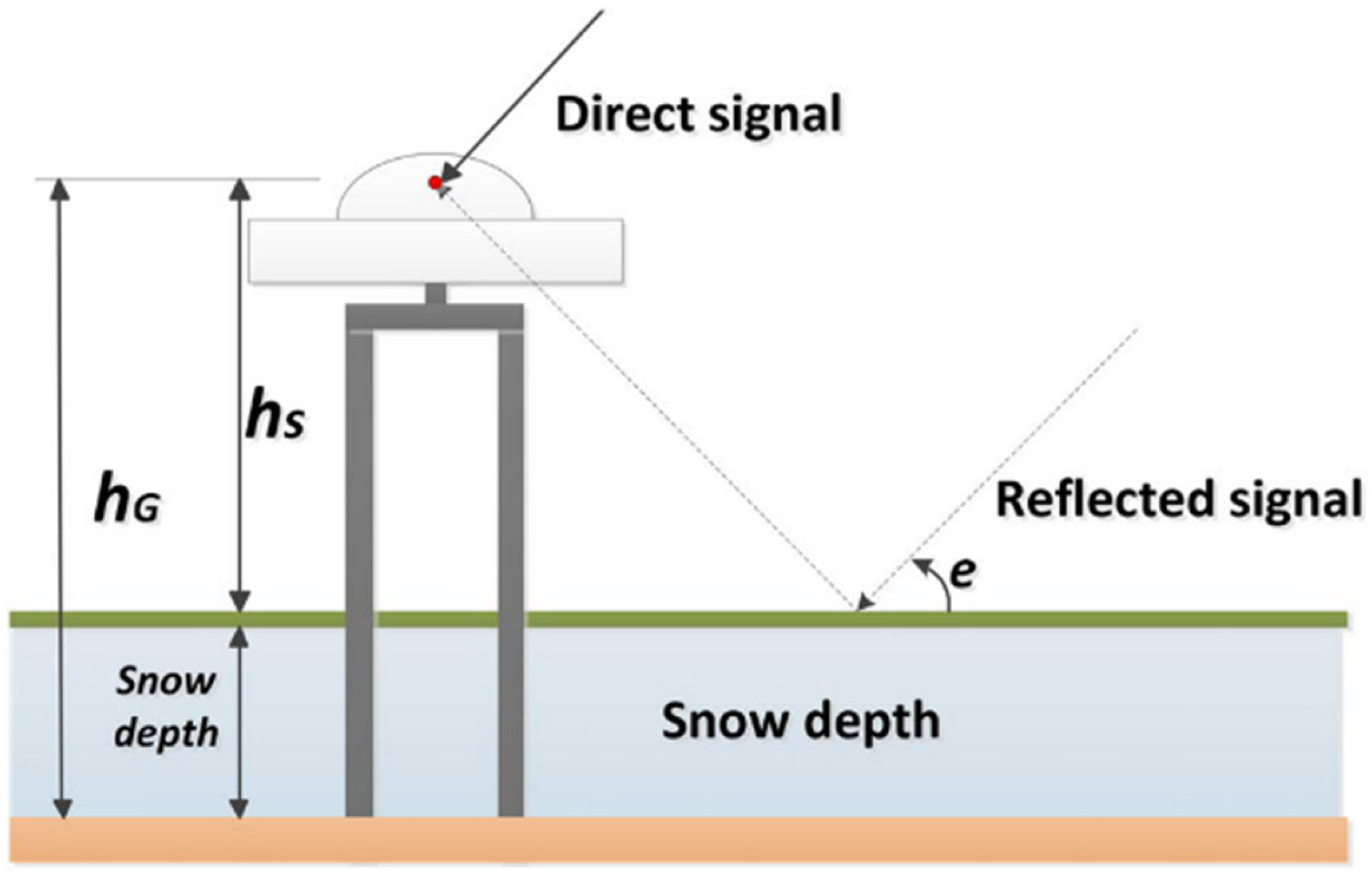


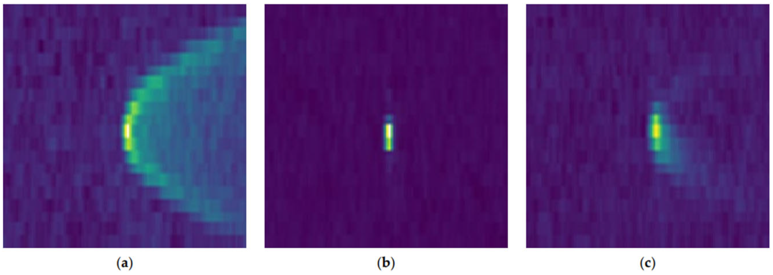


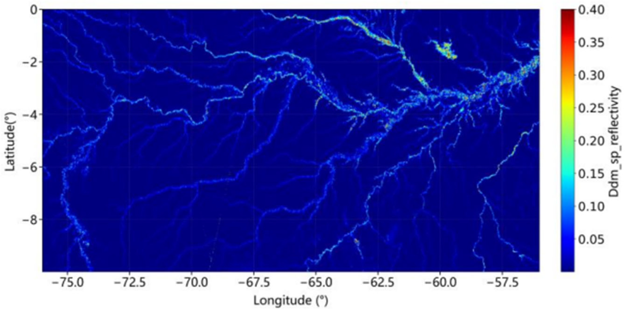
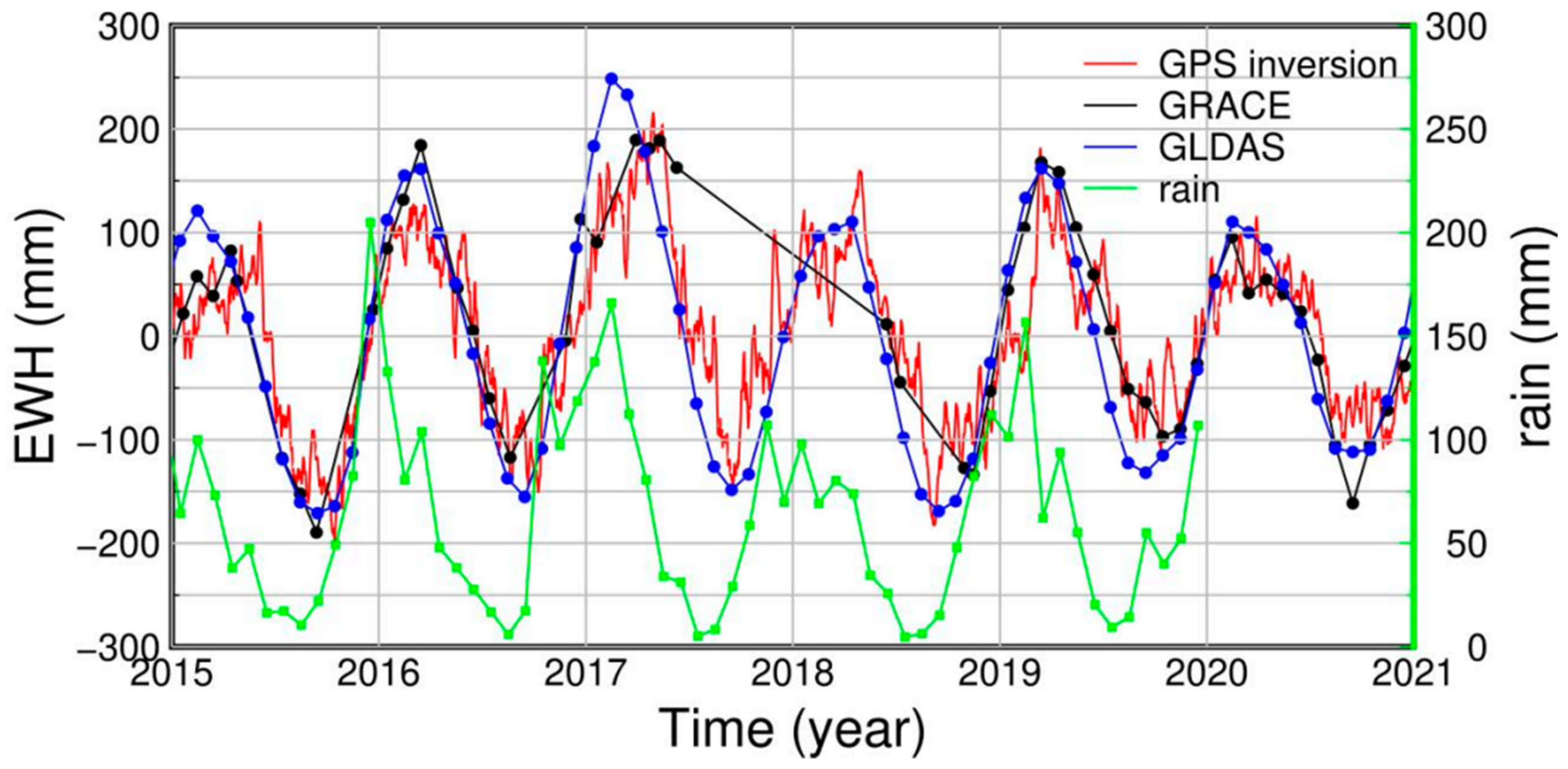
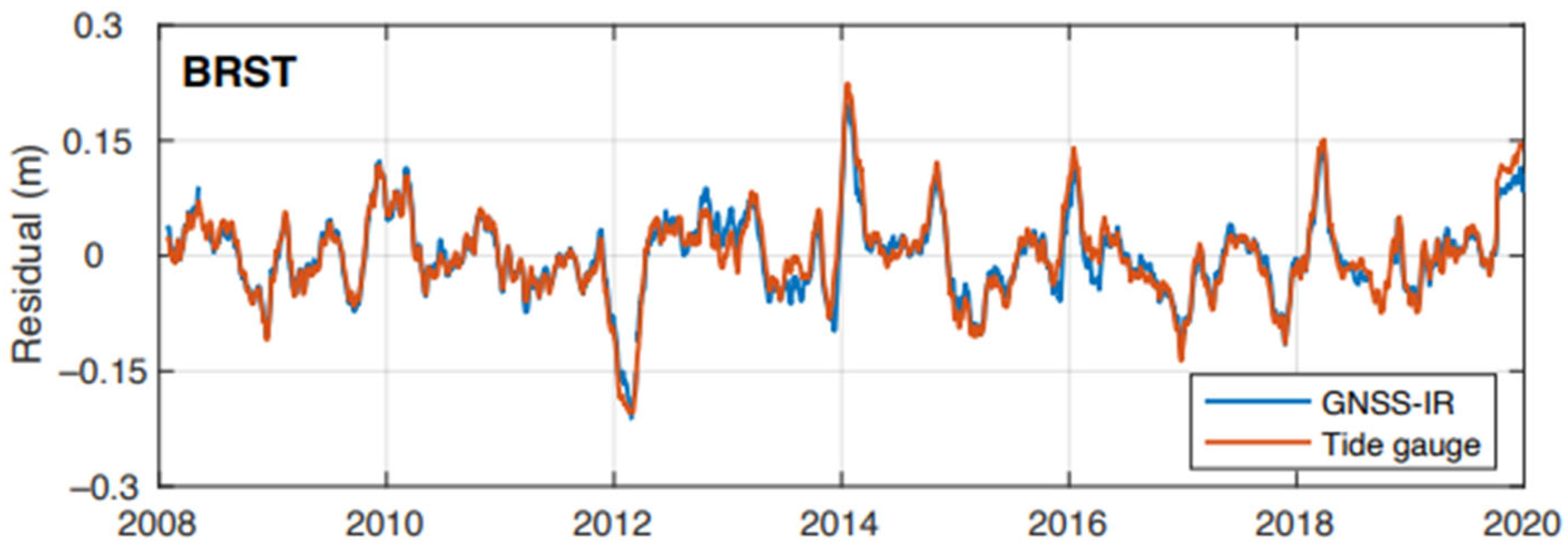

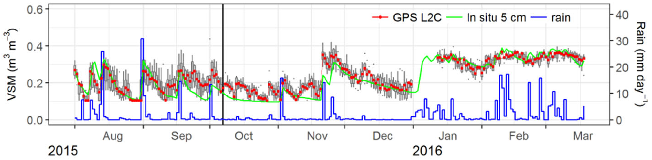
| Application Areas | Climate Monitoring | Tool | |
|---|---|---|---|
| Phenomena | Examples | ||
| Atmosphere | Troposphere |
| PPP CORS GNSS-RO |
| Ionosphere |
| PPP CORS | |
| Weather events |
| PPP CORS GNSS-RO | |
| Cryosphere | Sea ice |
| GNSS-R GNSS-IR |
| Snow |
| ||
| Glaciers and ice sheets |
| PPP RTK CORS | |
| Permafrost |
| PPP RTK CORS | |
| Hydrosphere (land water) | Inland water |
| PPP CORS GRACE |
| Groundwater |
| ||
| Hydrological phenomena |
| ||
| Oceans and seas | Sea level |
| GNSS-R GNSS-IR CORS PPP |
| Surface dynamics |
| GNSS-R GNSS-IR | |
| Coasts |
| PPP RTK CORS | |
| Geodynamics and biosphere | Crustal deformation |
| PPP RTK CORS |
| Biosphere |
| GNSS-R GNSS-IR | |
| GNSS Technique | Number of Publications (GNSS Technique + Climate Change) | Number of Publications (GNSS Technique) |
|---|---|---|
| GNSS-RO | 189 | 371 |
| PPP | 155 | 2679 |
| CORS | 123 | 1853 |
| GNSS-R + GNSS-IR | 266 | 577 |
| SUM | 733 | 5480 |
| Climate Variable | GNSS Technique | Alternative or Complementary Technique | Main Advantage over Alternative Methods |
|---|---|---|---|
| Vertical temperature and pressure profiles | GNSS-RO (e.g., MetOp) | Radiosondes, microwave radiometers | No requirement for instrumental calibration; high vertical resolution (~100–300 m) |
| PWV | CORS/PPP | Satellite infrared and microwave sensors | Continuous measurement (24/7) regardless of cloud cover and time of day; high temporal resolution |
| Snow depth and/or snow water equivalent (SWE) | GNSS-IR | LiDAR, UAV photogrammetry | Utilization of existing GNSS antennas without additional costs; non-invasive, continuous winter monitoring |
| Ground deformation and subsidence | CORS+InSAR | Piezometric wells, GRACE mission | Absolute, continuous 3D geodetic control, serving as calibration points for InSAR phase |
| Glacier mass balance and post-glacial rebound | PPP/CORS | Laser altimetry (ICESat-2), GRACE | Millimeter vertical accuracy is necessary to separate elastic rebound effects from GIA processes |
| Ocean wind speed and cyclones | Satellite GNSS-R (e.g., CYGNSS) | Scatterometers, oceanographic buoys | L-band signal penetrates torrential rainfall without signal saturation |
| Inland water extent and inundation | Satellite/Airborne GNSS-R | MODIS, Landsat, Sentinel-1 | High reflectivity from the water surface; complete insensitivity to cloud cover |
Disclaimer/Publisher’s Note: The statements, opinions and data contained in all publications are solely those of the individual author(s) and contributor(s) and not of MDPI and/or the editor(s). MDPI and/or the editor(s) disclaim responsibility for any injury to people or property resulting from any ideas, methods, instructions or products referred to in the content. |
© 2026 by the authors. Licensee MDPI, Basel, Switzerland. This article is an open access article distributed under the terms and conditions of the Creative Commons Attribution (CC BY) license.
Share and Cite
Maciuk, K.; Lewińska, P.; Brusak, I. Global Navigation Satellite Systems (GNSS) in Climate Change Research: A Comprehensive Review. Remote Sens. 2026, 18, 3001. https://doi.org/10.3390/rs18173001
Maciuk K, Lewińska P, Brusak I. Global Navigation Satellite Systems (GNSS) in Climate Change Research: A Comprehensive Review. Remote Sensing. 2026; 18(17):3001. https://doi.org/10.3390/rs18173001
Chicago/Turabian StyleMaciuk, Kamil, Paulina Lewińska, and Ivan Brusak. 2026. "Global Navigation Satellite Systems (GNSS) in Climate Change Research: A Comprehensive Review" Remote Sensing 18, no. 17: 3001. https://doi.org/10.3390/rs18173001
APA StyleMaciuk, K., Lewińska, P., & Brusak, I. (2026). Global Navigation Satellite Systems (GNSS) in Climate Change Research: A Comprehensive Review. Remote Sensing, 18(17), 3001. https://doi.org/10.3390/rs18173001