1. Introduction
Three well-known global changes are increasing carbon dioxide in the atmosphere, alterations in the biochemistry of the global nitrogen cycle and continuing land-use/land-cover change [
1]. Land-use/land-cover change (LULC) generates many environmental consequences globally and locally, such as the release of greenhouse gases, the loss of biodiversity and the sedimentation of lakes and streams [
2]. In particular, it is recognized as the major driver of the loss of biodiversity and ecosystem services [
3]. The effect of land use change on biodiversity may be greater than climate change, nitrogen deposition, biotic exchange, and elevated carbon dioxide concentration at the global scale [
4]. Deforestation is known as one of the most important elements in LULC. Large-scale deforestation is occurring in the tropical forests, which contain most of the species in the world [
5]. Globally, deforestation has been occurring at an alarming rate of 13 million hectares per year [
6].
In Vietnam, two-thirds of the territory was primary forest until the mid-twentieth century [
7]. Though forest cover in the country as a whole was 40.7% in 1943, it declined to 27.7% by 1993 [
8]. Primary forest was deforested to its lowest levels in the late 1980s and early 1990s [
9]. Vietnam’s deforestation rate was the highest among low-income countries over the period from 1965 to 1989 [
10]. This trend still continued for the period from 1990 to 2005. The primary forest area per total forest area for the entire country declined from 4.1% in 1990 to 0.7% in 2005 [
6]. However, from the mid-1990s until now, there has been an increase in new forest plantations across the country [
9].
Deforestation not only reduces forest area but also alters landscape configuration. Therefore, protected areas should be established to maintain the large, contiguous areas of forests for the protection of threatened species. Globally, 11.2% of the total forest area had been designated for the conservation of biological diversity in 2005 [
6]. In Vietnam, protected areas were established in most of the representative ecological zones for the period from 1995 to 2005. The country’s protected areas now account for 14.7% of the total forest area [
6]. Many protected areas in the country are experiencing forest changes [
11]. The management of the remaining forests within protected areas is very difficult to achieve because the livelihoods of local residents in the surrounding areas often heavily depend on agriculture and the extraction of forest products [
12]. From a protected area management perspective, there is a need to identify the areas vulnerable to forest conversion in order to prioritize conservation efforts. One way to achieve this identification is to use remote sensing data and spatial models to map forest change patterns. Satellite remote sensing plays a key role in mapping and predicting forest changes [
13,
14]. Satellite imagery provides an accurate measure of forest cover and deforestation [
15]. Changes in land use, derived from remotely sensed data, can be related to landscape and location attributes. A model can be established to describe the relationship between the dependent variable (forest cover change) and independent location variables [
16]. Then, the model can be used for predicting the spatial patterns of forest cover changes.
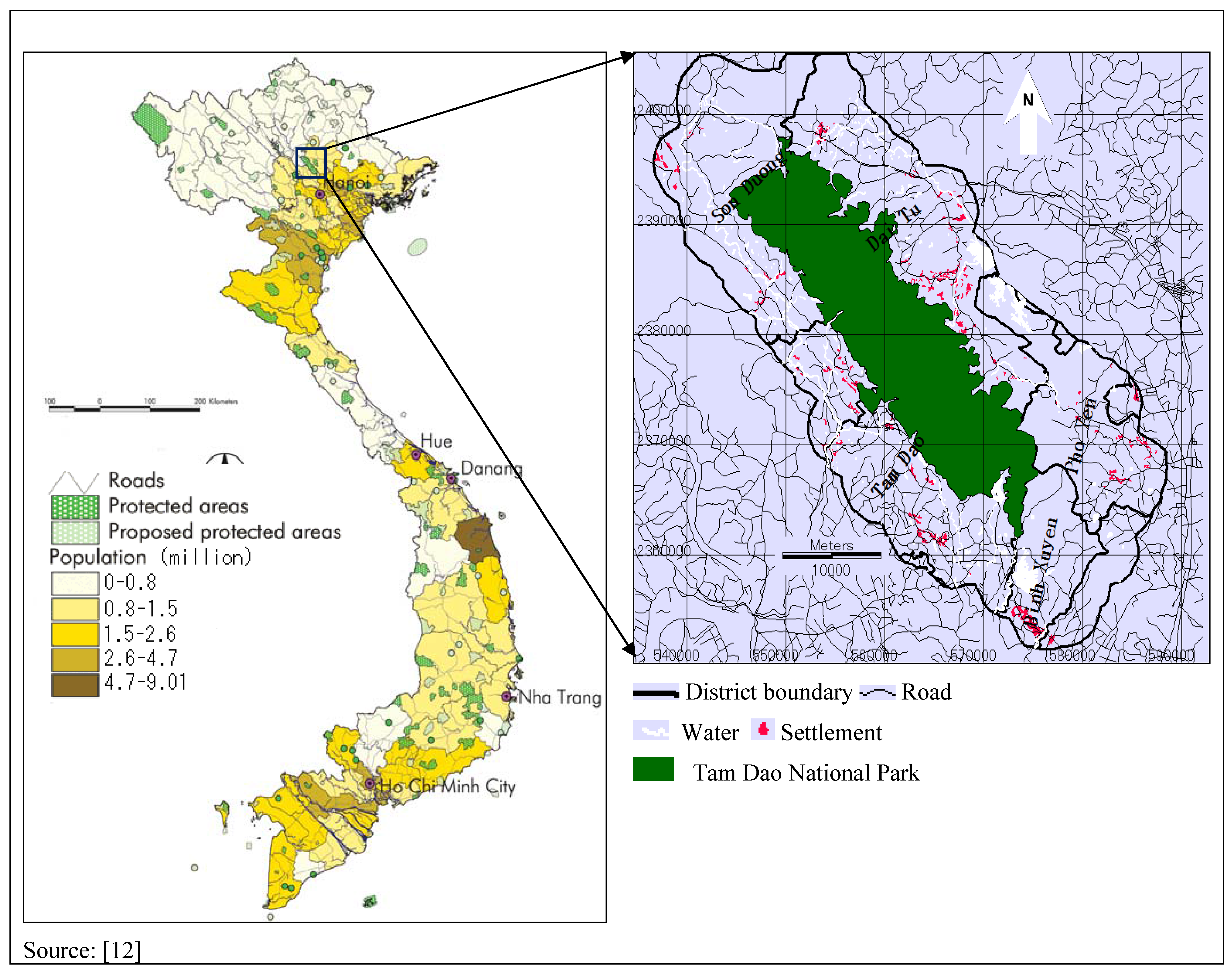
Tam Dao National Park (TDNP) is a protected area in Vietnam. It contains the last remaining primary forest. It is endowed with rich biodiversity and is known to host a number of rare and endemic animal species. Yet, the park has been experiencing considerable forest changes due to population pressure in the surrounding areas. As a result, several species are in danger. For example, 45 rare animal species are known to be threatened by habitat destruction [
17]. Much of the primary forest has been cleared for cropland. These forest changes are exerting an increasing pressure on biodiversity conservation efforts. Different protection measures have been introduced to control forest logging, but illegal logging is still a significant threat to the remaining forest areas [
12].
Modeling forest conversion can be an important instrument for understanding forest cover dynamics in the TDNP region. Forest change models can provide a better understanding of the factors that drive forest changes, they can generate future forest cover scenarios, and they can support the design of policy responses to forest changes [
18]. Forest change is associated with multiple factors. The relationships between change and its driving factors can be very complex and are often non-linear [
19], requiring an appropriate modeling approach that accounts for such complex non-linear relationships.
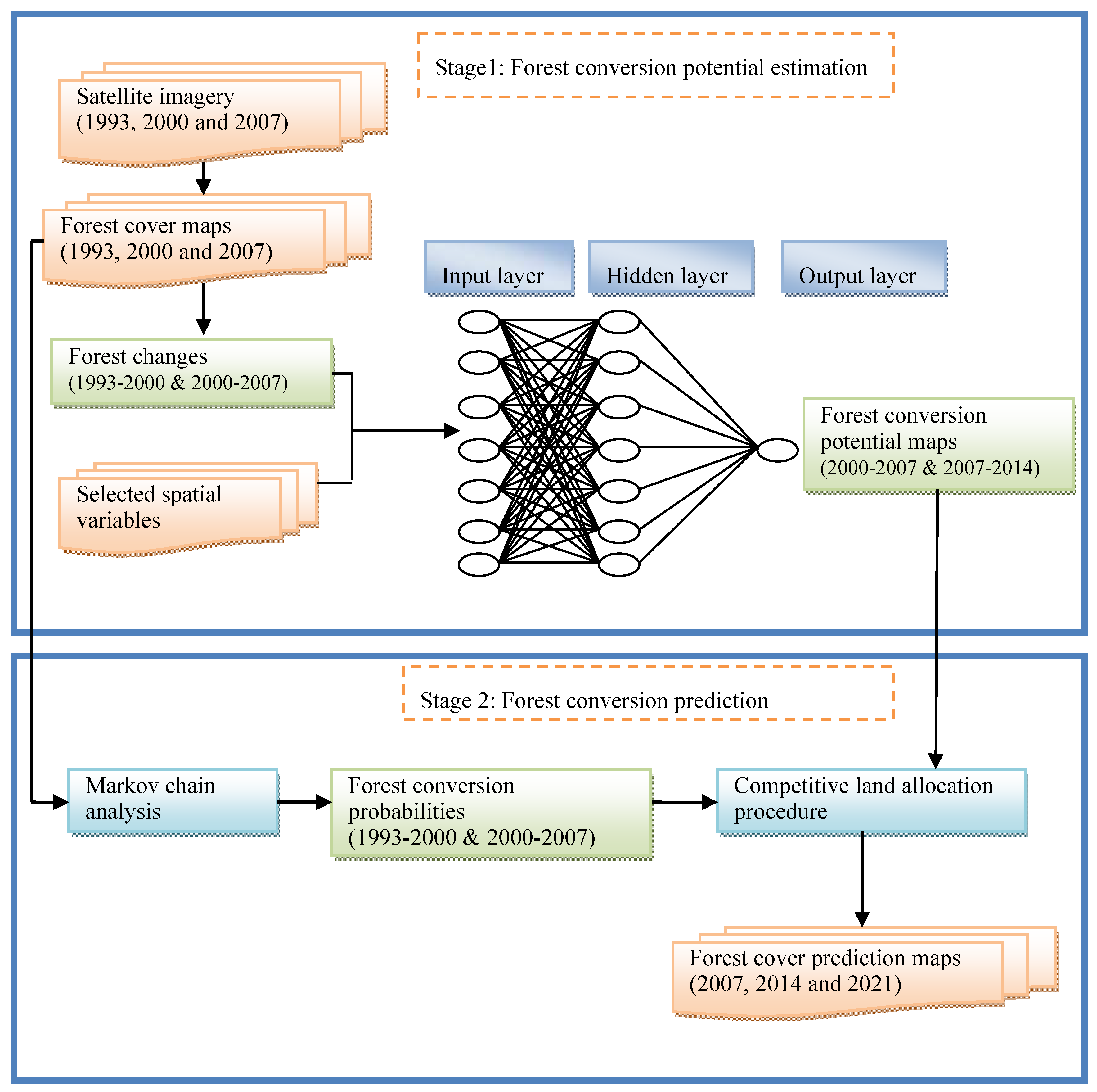
Forest change can be predicted using empirical models and simulation models [
16]. The multi-layer perceptron neural network (MLPNN) with an integrated Markov model (M) (hereby referred to MLPNN-M) is a recently developed approach for spatiotemporal dynamic modeling of forest change [
20]. The MLPNN allows the integration of the driving factors of forest change, whereas the Markov model controls the temporal dynamics of forest change. A multi-regression approach often performs poorly when the relationships between variables are non-linear and some variables must be transformed. Conversely, the MLPNN models are good at dealing non-linear relationships and do not require the transformation of variables [
21]. It is generally recognized that the MLPNN models can perform better in land change modeling [
19,
21,
22,
23]. In a recent study, the MLPNN was found to be better than logistic regression and other empirical modeling tools, such as empirical probabilities and empirical likelihoods, in land change modeling [
20]
This paper aims to predict areas vulnerable to forest conversion in the TDNP region using remote sensing data and the MLPNN-M model. Multi-temporal satellite images were used to detect changes in forest cover, and then the MLPNN-M model was applied to predict changes in forest cover in the near future. Predicting forest change patterns provides important information for identifying priority areas for conservation and forest management in the TDNP region. These predictions may improve the efficiency of efforts to protect the remaining primary forest in the study area.
4. Discussion
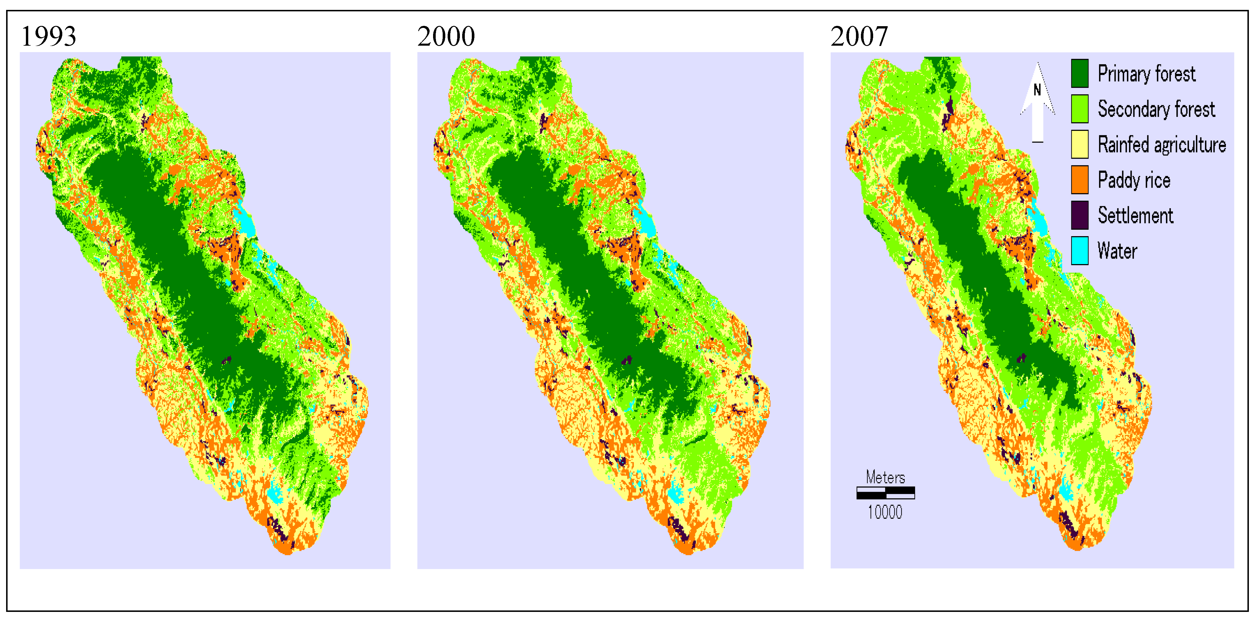
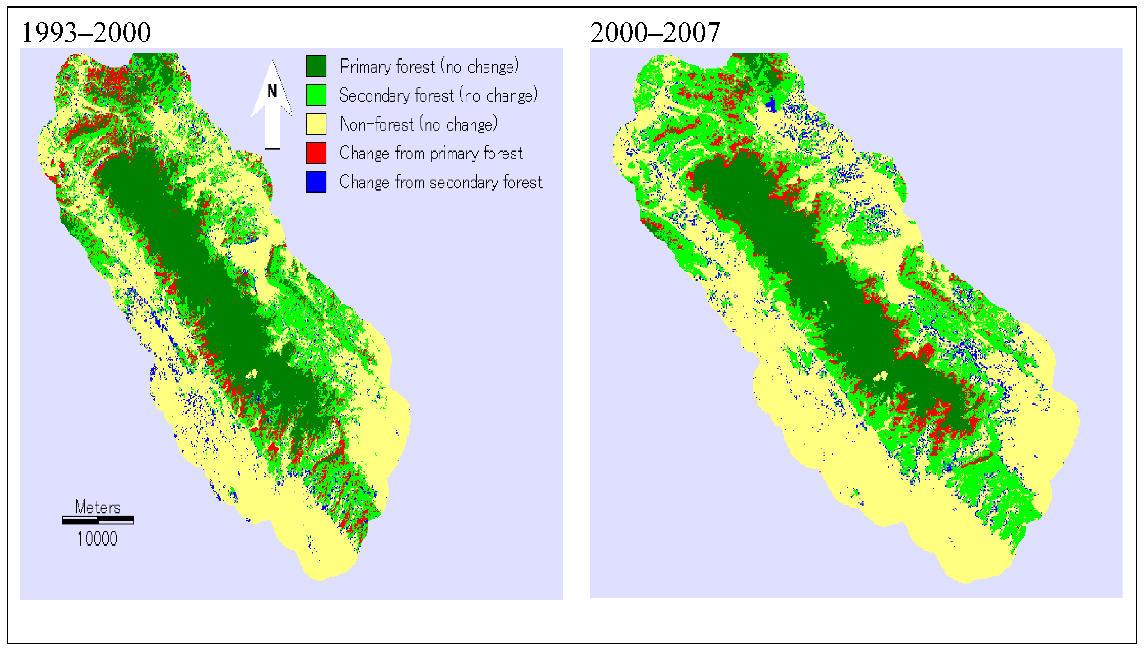
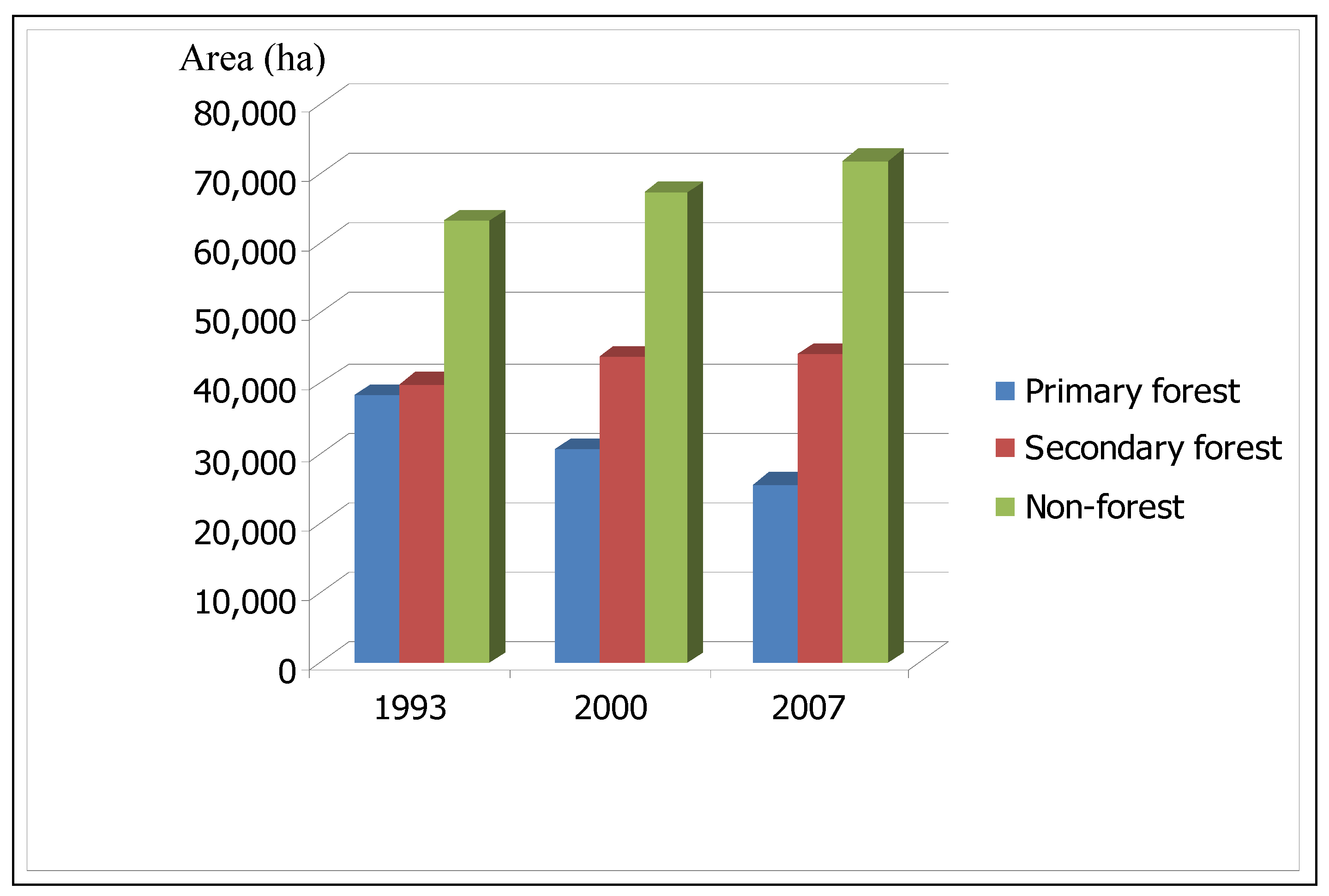
The conversion of primary and secondary forest for the periods from 1993–2000 and 2000–2007 was observed within the strictly protected primary forest and the buffer zone. The primary forest loss for 1993–2000 was bigger than that for 2000–2007. Thus, primary forest loss still continues by illegal forest logging [
12]. Similarly, a considerable primary forest loss was observed across the country during the period from 1990 to 2005 [
6]. This conversion is a common trend in tropical forests [
37,
38]. The conversion of secondary forest to non-forest during the first period may be linked to a 1993 land law that provided land-use rights to individual households. Furthermore, government agricultural production input subsidies, such as crop varieties and fertilizers and improved access to credit and markets could contribute to this conversion trend. Similar conversions have been observed in other protected areas [
11] and mountainous areas of Vietnam [
33], and they have occurred in many other countries, particularly in developing countries. For example, [
39] found that deforestation was strongly correlated with the extension of cropland area in Asia and Latin America.
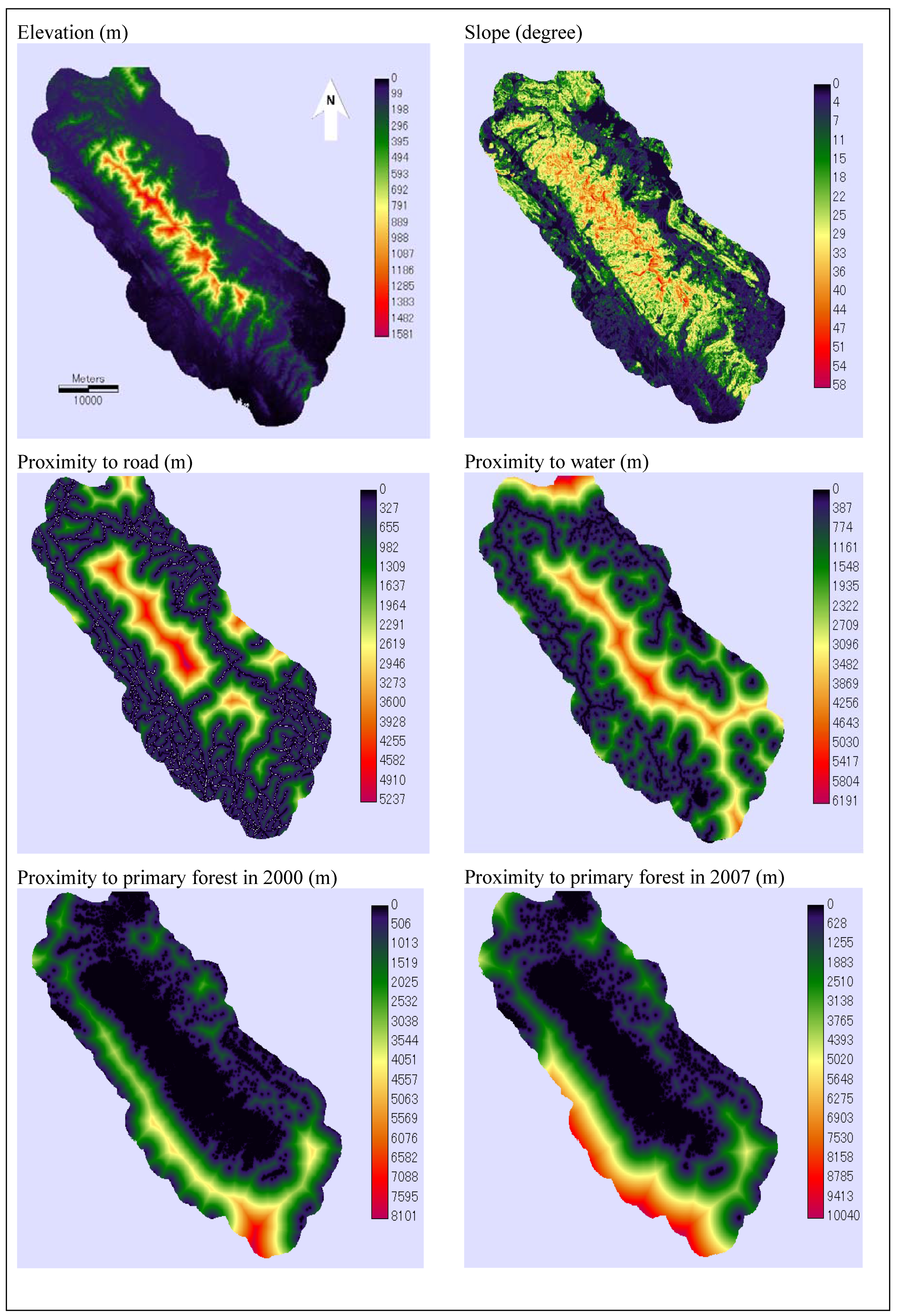
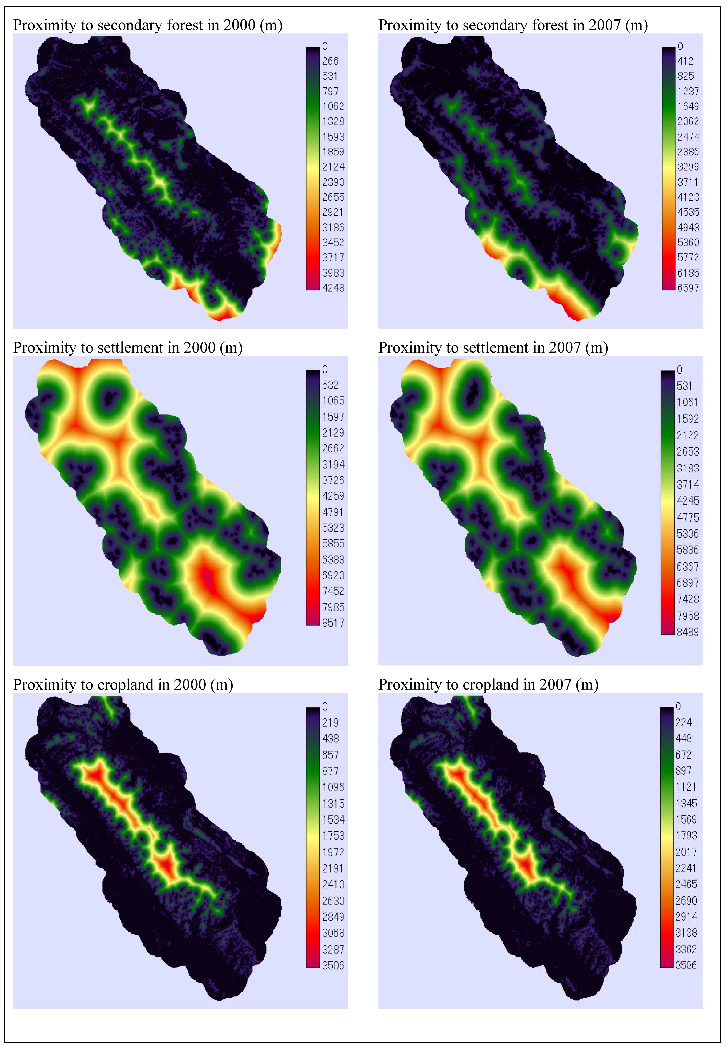
There may be many driving factors of forest conversion, and they may vary from place to place. In our case study, selected spatial variables composed a considerable share of the factors driving forest changes. In particular, the accessibility variables seemed to be more important than the topographical ones. Many of these factors have been found to be important in other areas. For example, [
40] identified proximity to road, town and forest/non-forest edge as important drivers of forest change in southern Cameroon. Elevation and proximity to road were highlighted as important factors of forest change in the lowlands of Sumatra, Indonesia [
13]. Elevation, slope, proximity to road, settlement and proximity to forest/non-forest edge were the key factors of forest change in southeast Mexico [
19]. Aside from these biophysical factors, socio-economic factors are often recognized as underlying driving forces of forest cover changes [
39,
41] and also play an important role in changing landscape. Although these underlying factors are the main pressures on forest conversions, their effect frequently comes from outside the forested areas. For example, the population in the secondary forest edge may have less influence on the conversion of secondary forest to tea plantations than populations outside these areas. This conversion may be caused by tea demand that originates from places further away. Therefore, our empirical analysis was based solely on the site factors of forest conversions.
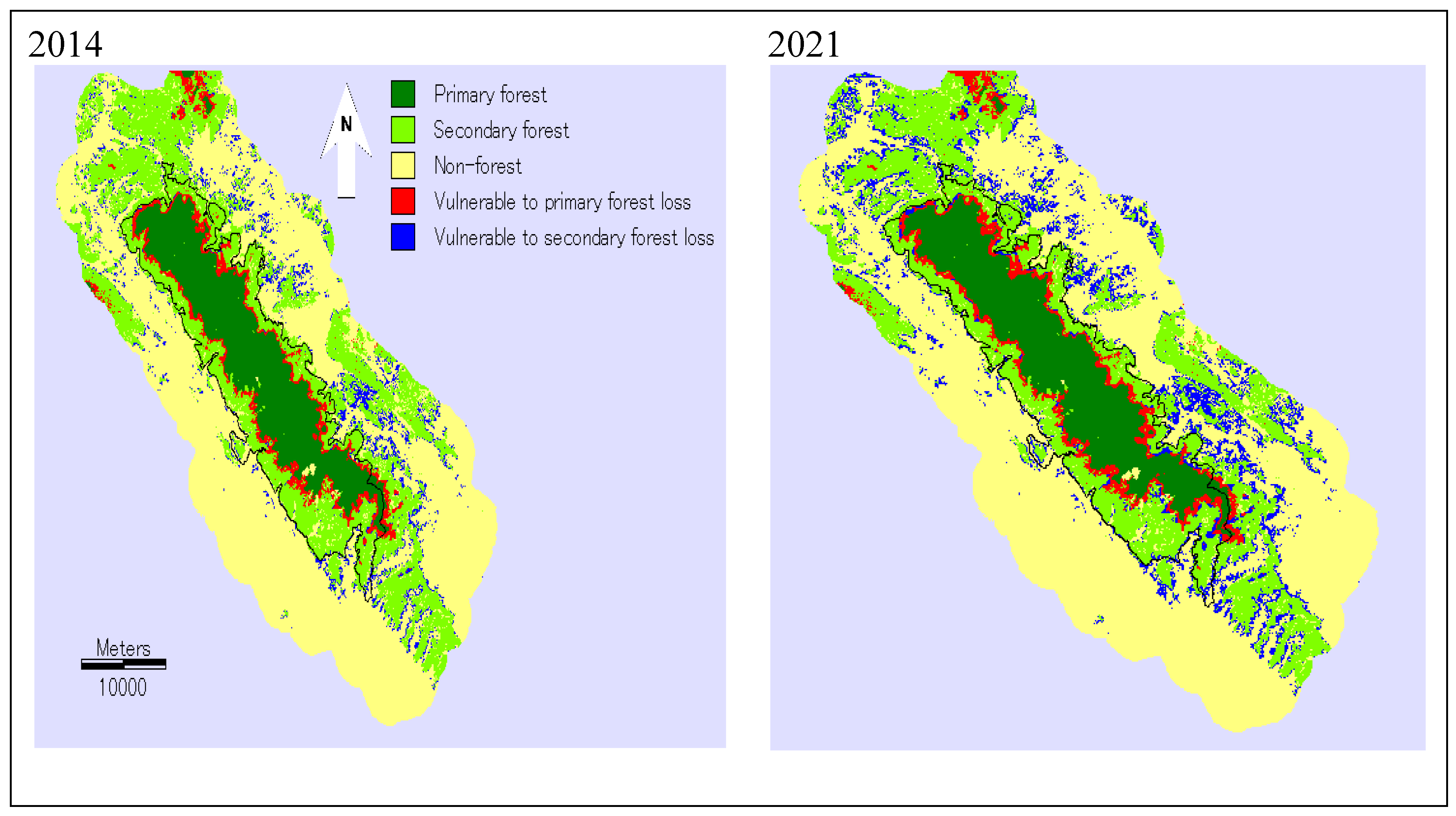
The predicted forest changes are based on the assumption that forest changes will follow the 2000–2007 Markovian dynamics. In this area, the trends used in our predictions were largely driven by population pressure, and may be conservative. Increasing population, the high incidence of poverty, and the poor awareness of conservation among local residents have contributed to the loss of the primary forest and the conversion of secondary forest into cropland [
12]. Forest conversion tended to occur in land suitable for agriculture. Shifting cultivation and commercial tea plantations were causes of cropland expansion into primary and secondary forest areas in the past. In particular, commercial tea plantations exist within the boundary of the park. Tea plantations may continue to extend into the primary forest area in the future because the area is highly suitable for tea plantations.
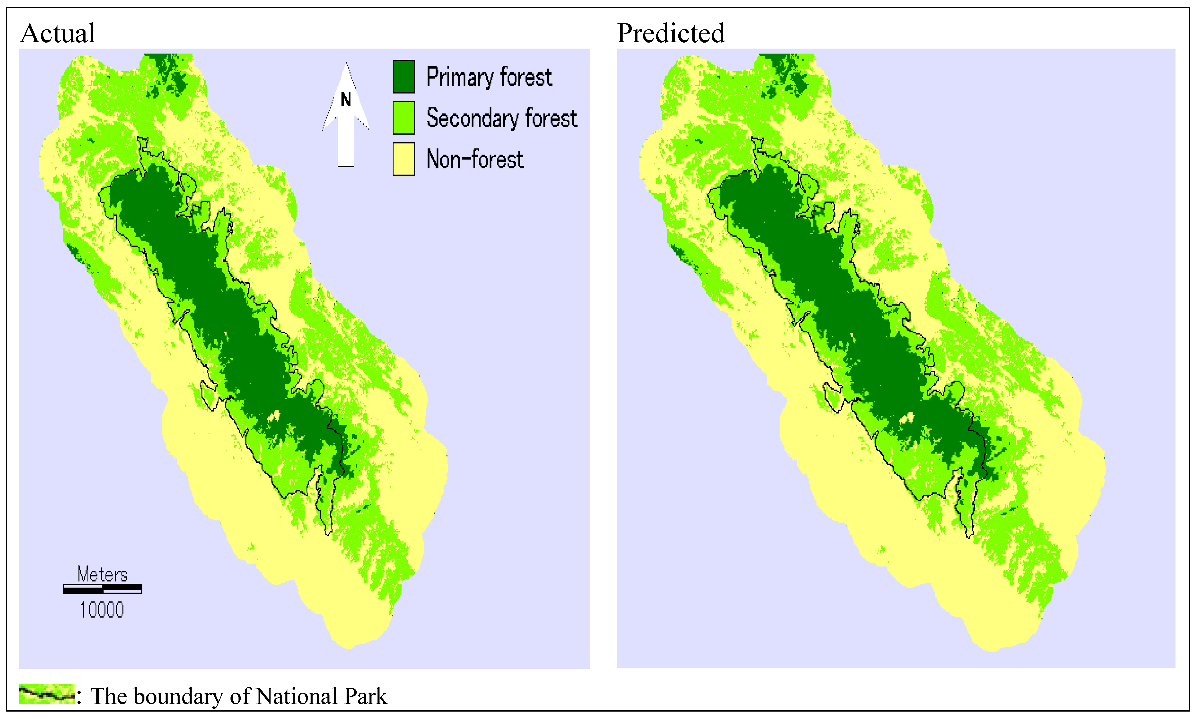
The identification of the areas vulnerable to forest changes is fundamental in the TDNP and has important implications for biodiversity conservation in the region. One of the most important applications would be to relate the spatial patterns of forest changes to the spatial distribution of species. This is particularly important for large protected areas. Surveys on the distribution of plant species in the area showed that the remaining primary forest within the park is the most structurally complex and richest in plant species composition, particularly in the areas from 350 to 800 meters above mean sea level [
42]. According to our predictions, forest loss is likely to occur within this range of elevation. The loss of the remaining primary forest will threatens the survival of many species in the region. In particular, cultivation within primary forest areas drastically altered the composition and abundance of plant species [
24]. In addition, the conversion of secondary forest into cropland indicates increasing pressure on the steep land areas in the surrounding areas, and may cause severe land degradation in the future due to soil erosion. Continuing soil degradation may pose a threat to the natural resource-based local economy.
From a protected area management perspective, the prediction maps of forest change patterns can help protected area managers identify where conservation and forest management efforts should be focused. This approach is particularly significant in Vietnam because limited finance resources for protected areas require focused efforts for conservation. Most of the government funding for protected areas is spent on salaries of forest rangers and not on development activities for affected populations. At a larger scale, the prediction of forest change patterns can aid long-term sustainable forest management.
5. Conclusions
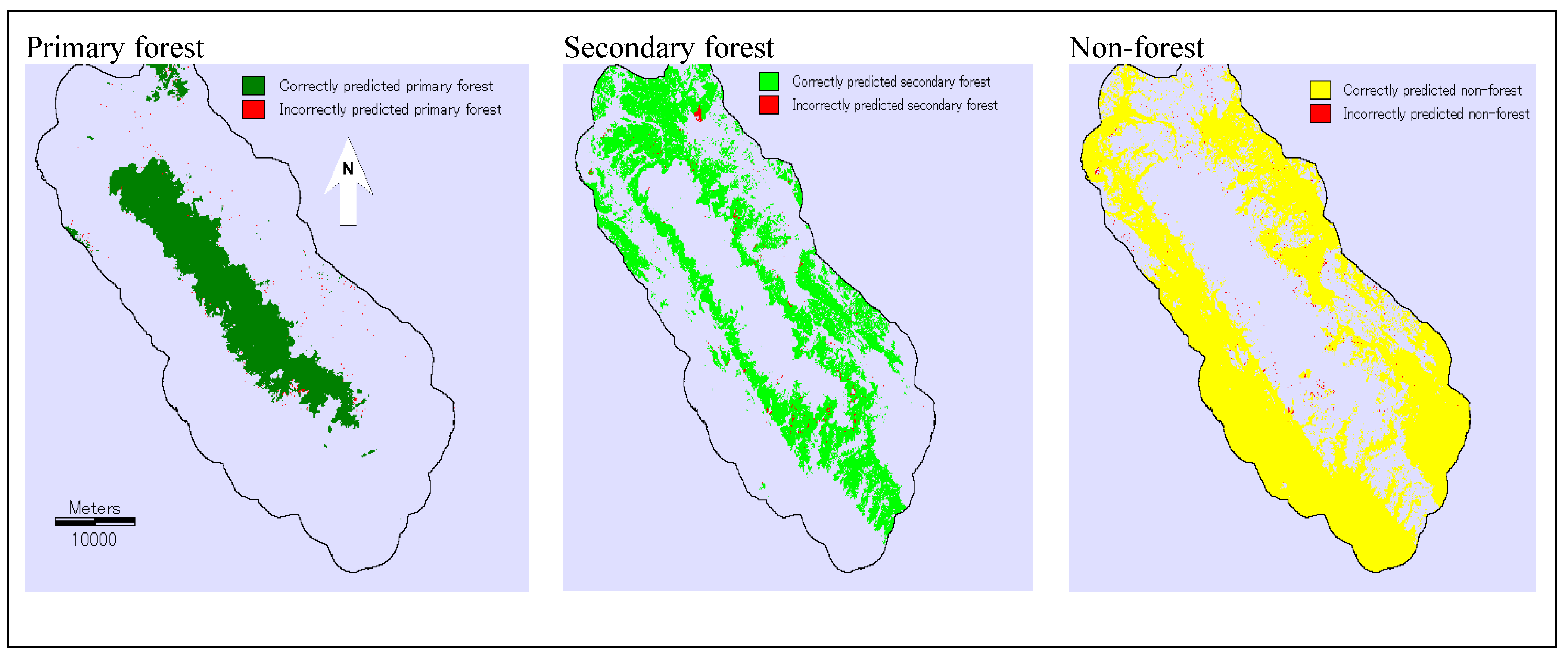
This study investigated the conversion of primary and secondary forest using remote sensing and the MLPNN-M model in Vietnam’s TDNP region. We parameterized the MLPNN-M model to simulate the conversion of primary forest and secondary forest in the near future. The rates and driving factors of forest changes were identified using remote sensing data. Then, these data were used to calibrate the model for projecting forest change patterns. The results of model validation showed that selected spatial variable proved to be a considerable part of the variables driving forest conversion in the area; therefore, the model was accurate at predicting the location of forest cover in 2007. However, the more successful component of the model was its prediction of the quantity of forest cover in 2007. Based on the 2007 model validation scenario, the forest cover in 2014 and 2021 was simulated to identify areas that are vulnerable to conversion of primary and secondary forest. According to our model predictions, a considerable portion of primary forest within the park is threatened by forest clearance, which indicates that intensified protection measures are required to prevent further loss of primary forest. The secondary forest in the steep areas in the buffer zone of the park is likely to be converted into agricultural land, and these areas are susceptible to soil erosion. The methodology and results produced in this study can be a vital tool for monitoring the remaining primary and secondary forest in the TDNP region. The monitoring process can be implemented by regularly updating Landsat-derived maps of forest cover and predicting forest change patterns. Moreover, the prediction maps can be used to focus biological conservation efforts. The methodology can also be used more widely for conservation planning and management in other protected areas that are experiencing forest changes in Vietnam.
The model predicted quite reasonably the spatial patterns of forest changes in the study area; however, reforestation was not taken into account. Recently, deforestation and reforestation has been occurring simultaneously in the TDNP region. Therefore, future studies should attempt to include the reforestation process in order to further understand the dynamics as well as the patterns of forest changes in this area.


