Using Remote Sensing Products for Environmental Analysis in South America
Abstract
:1. Introduction
2. Data and Methodology
2.1. GLOBCOVER
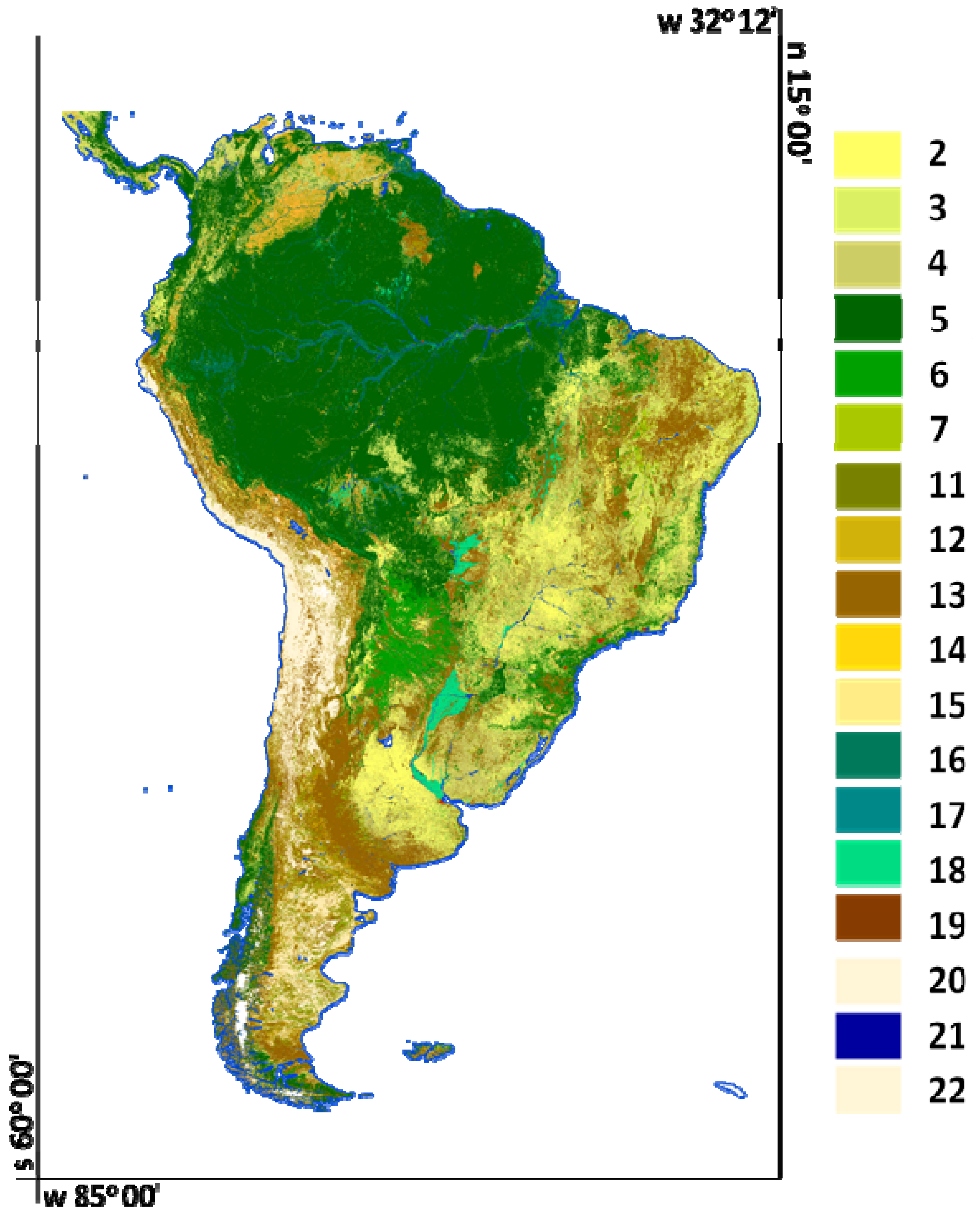
| Number | Land use and land cover class |
|---|---|
| 2 | Rainfed croplands |
| 3 | Mosaic cropland (50–70%)/vegetation (grassland/shrubland/forest) (20–50%); |
| 4 | Mosaic vegetation (grassland/shrubland/forest) (50–70%)/cropland (20–50%) |
| 5 | Closed to open (>15%) broadleaved evergreen or semi-deciduous forest (>5 m) |
| 6 | Closed (>40%) broadleaved deciduous forest (>5 m) |
| 7 | Open (15–40%) broadleaved deciduous forest/woodland (>5 m) |
| 11 | Mosaic forest or shrubland (50–70%)/grassland (20–50%) |
| 12 | Mosaic grassland (50–70%)/forest or shrubland (20–50%) |
| 13 | Closed to open (>15%) (broadleaved or needleleaved, evergreen or deciduous) shrubland (<5 m) |
| 14 | Closed to open (>15%) herbaceous vegetation (grassland, savannas or lichens/mosses) |
| 15 | Sparse (<15%) vegetation |
| 16 | Closed to open (>15%) broadleaved forest regularly flooded (semi-permanently or temporarily)—Fresh or brackish water |
| 17 | Closed (>40%) broadleaved forest or shrubland permanently flooded—Saline or brackish water |
| 18 | Closed to open (>15%) grassland or woody vegetation on regularly flooded or waterlogged soil—Fresh, brackish or saline water |
| 19 | Artificial surfaces and associated areas (Urban areas >50%) |
| 20 | Bare areas |
| 21 | Water bodies |
| 22 | Permanent snow and ice |

2.2. Vegetation Continuous Fields (VCF)
2.3. Tropical Rainfall Measuring Mission (TRMM)
2.4. Fire Radiative Power (FRP)
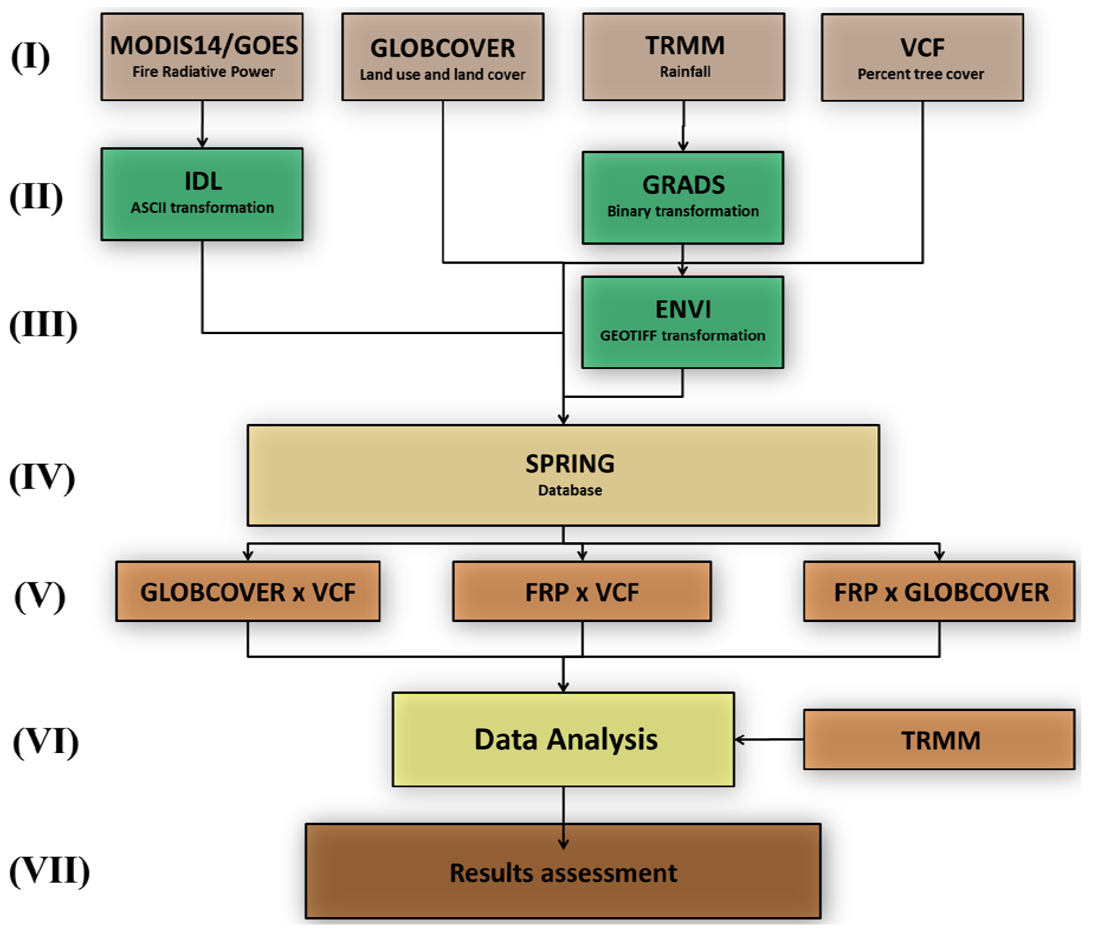
2.5. Data Processing
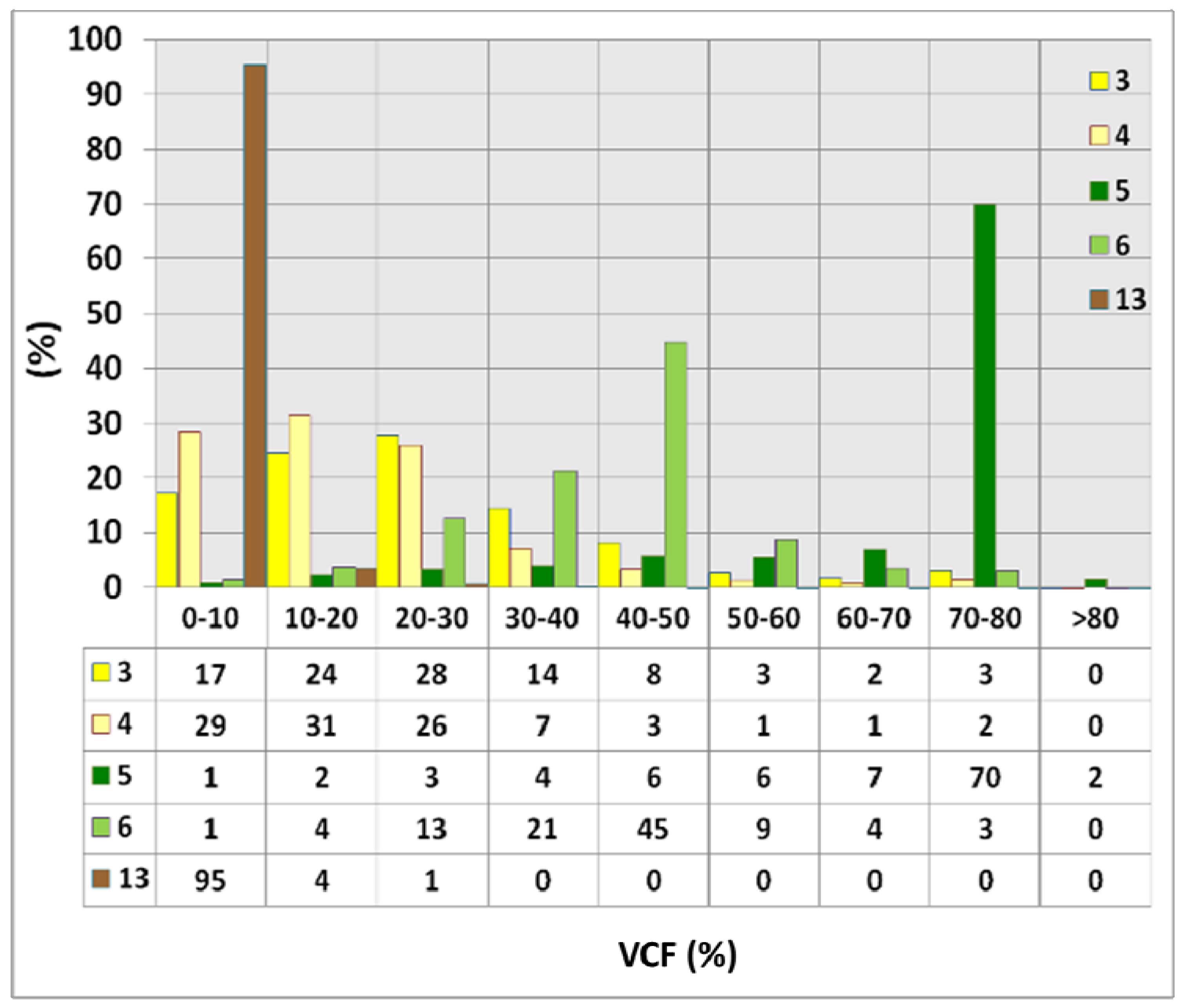
3. Results and Discussion
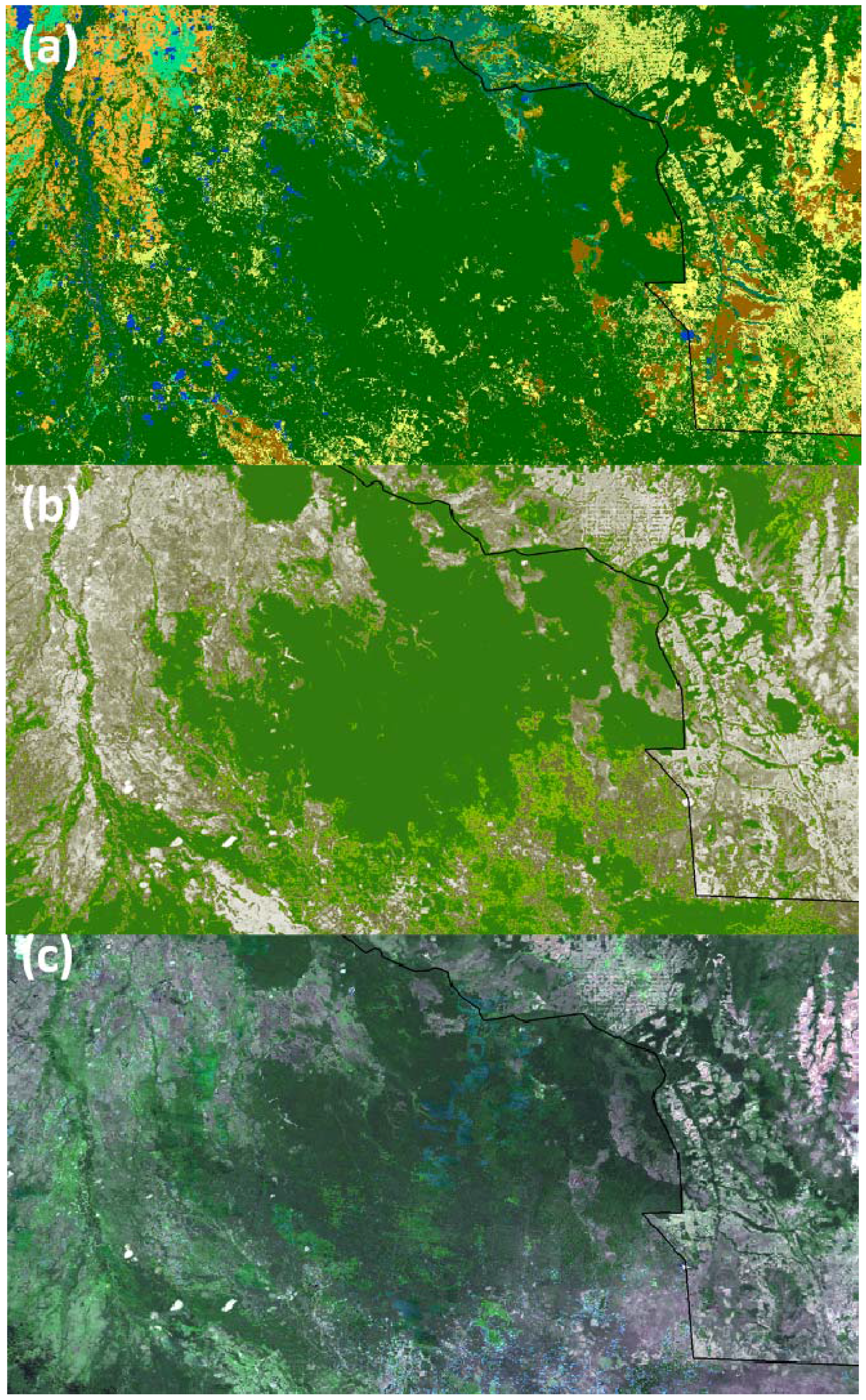
3.1. GLOBCOVER Assessment with VCF
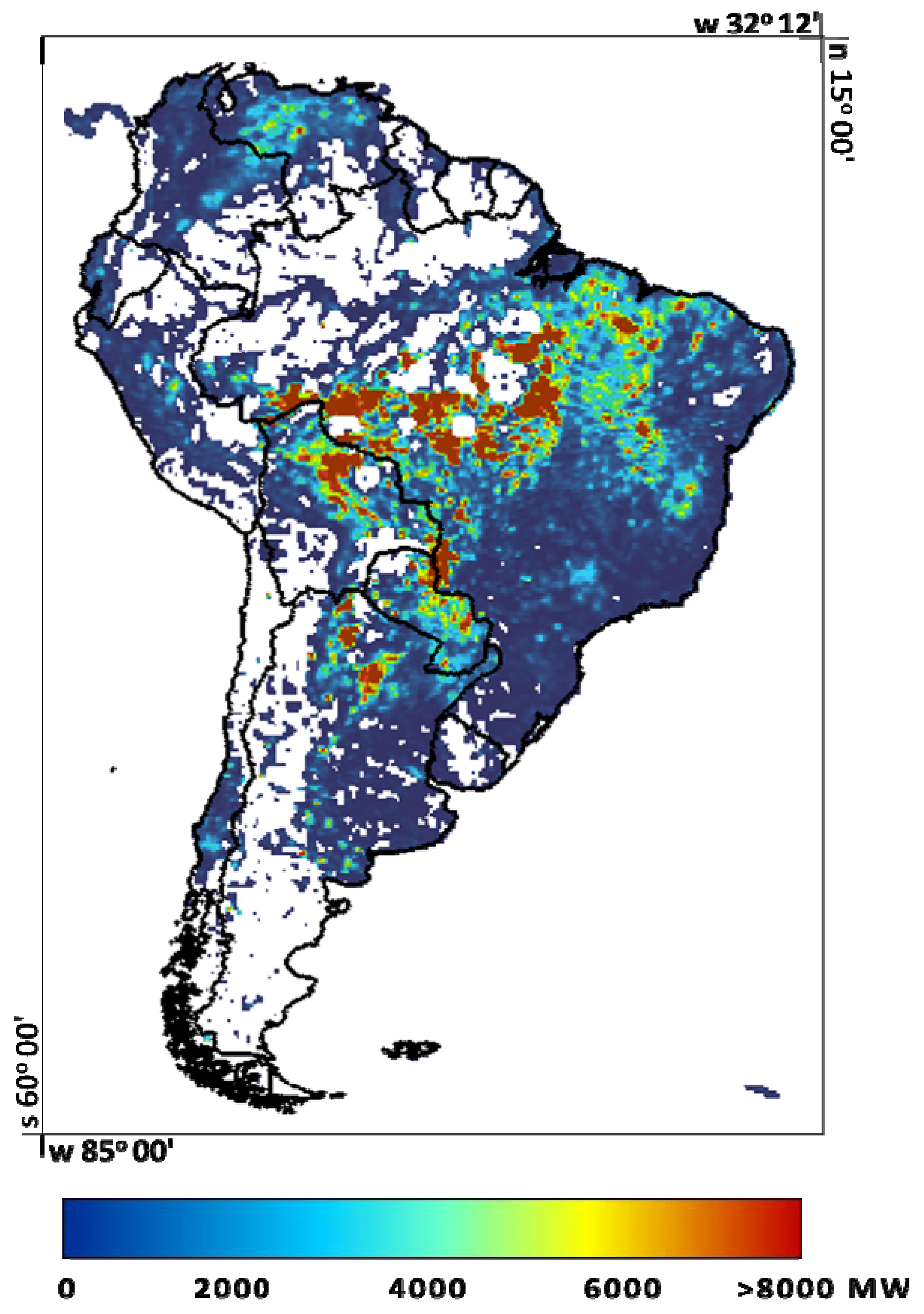
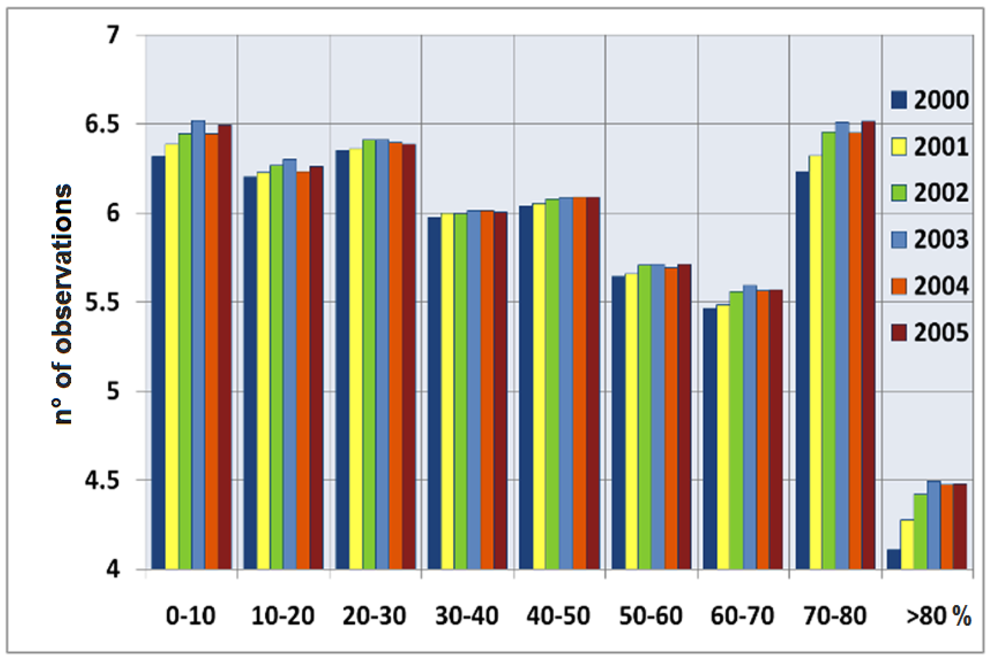
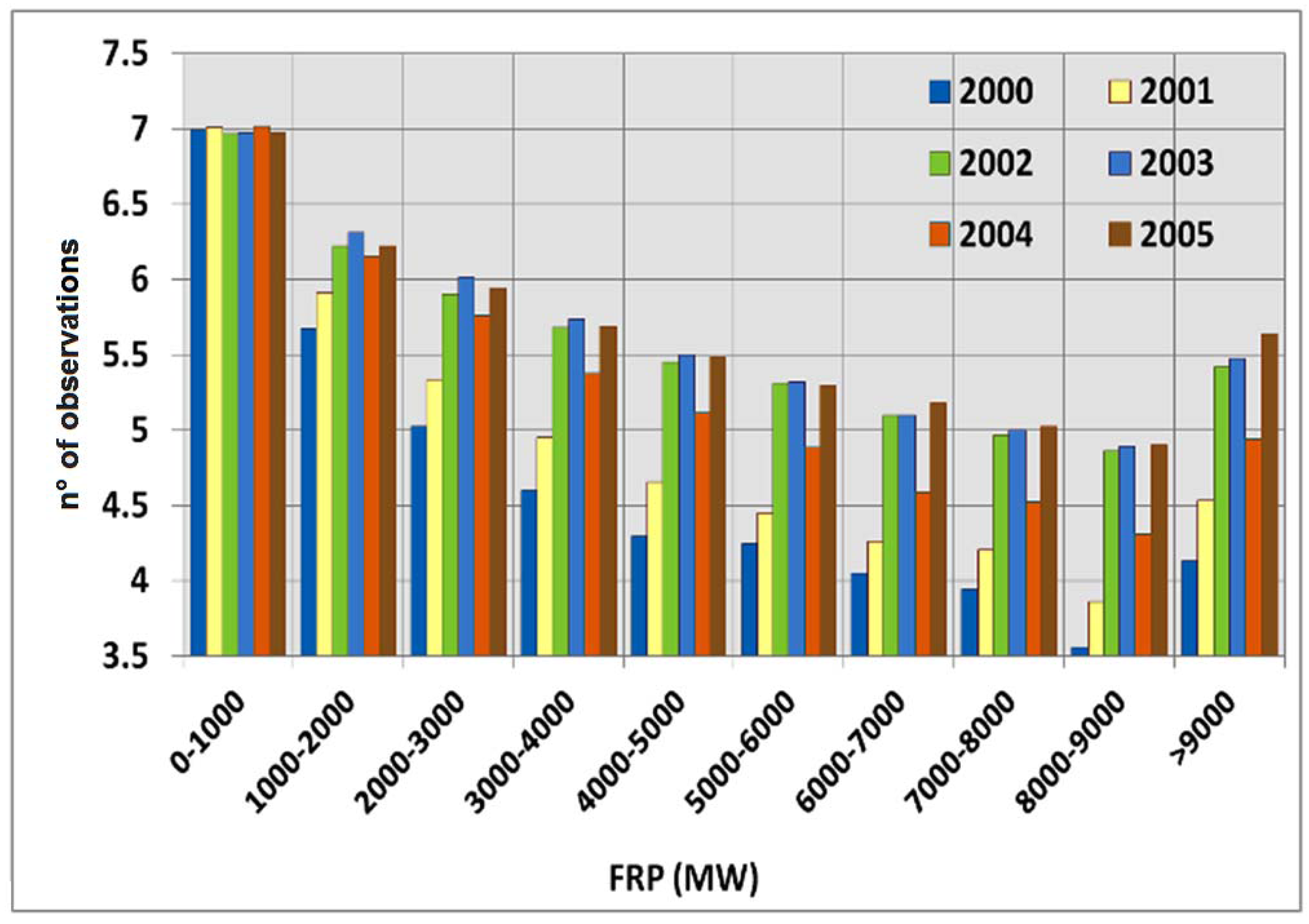
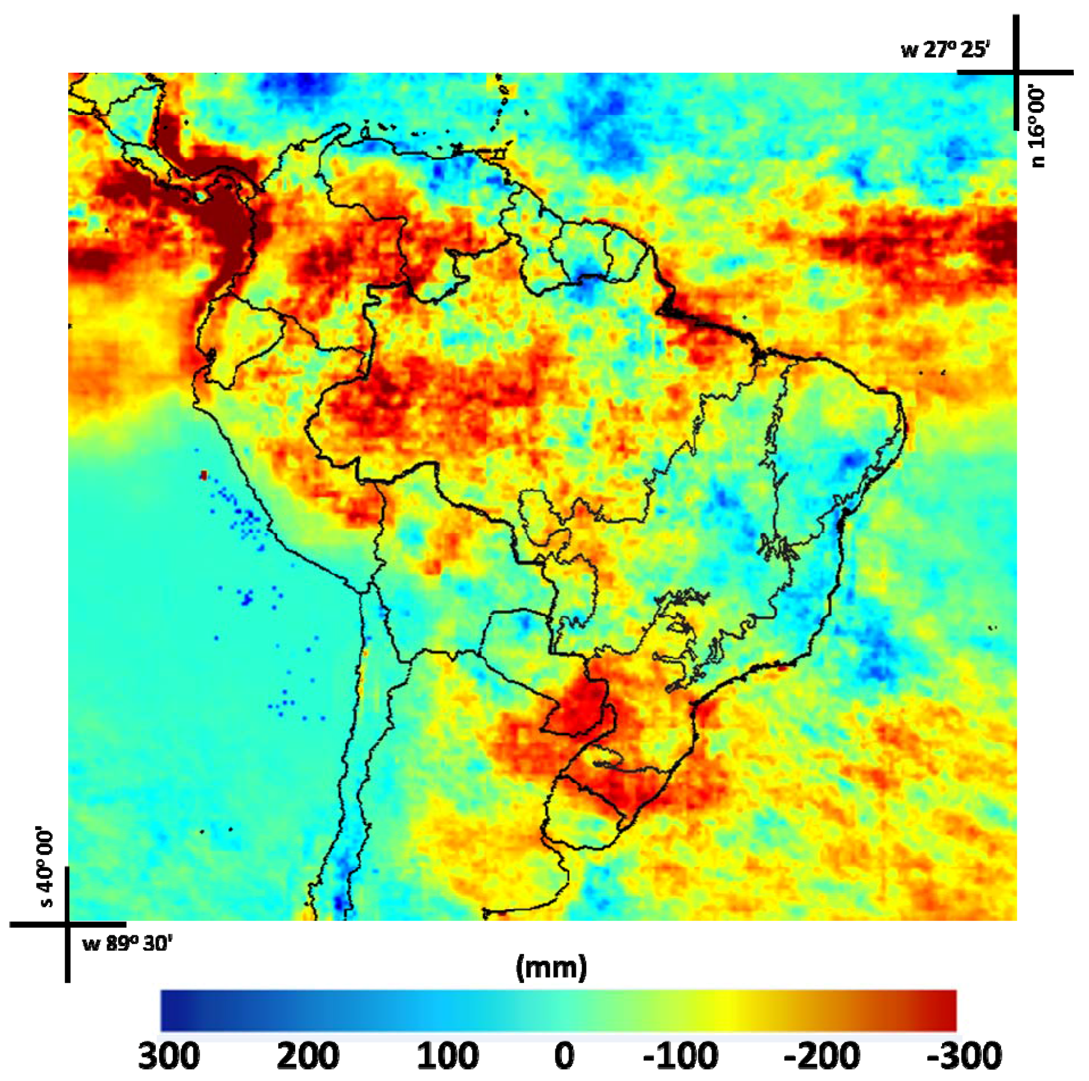
3.2. 2000 to 2005 South America Biomass Burning
| GLOBCOVER LULC | (%) |
|---|---|
| 2 | 6.4 |
| 3 | 7.8 |
| 4 | 9.3 |
| 5 | 38.9 |
| 6 | 3.8 |
| 7 11 | 0.5 3.2 |
| 12 | 1.5 |
| 13 | 16.6 |
| 14 | 2.0 |
| 15 | 3.3 |
| 16 | 1.6 |
| 17 | 0.1 |
| 18 | 1.4 |
| 19 | 0.1 |
| 20 | 3.1 |
| 22 | 0.4 |
4. Conclusions
Acknowledgements
References
- Kaufman, Y.J.; Justice, C.O.; Flynn, L.; Kendall, J.D.; Prins, E.M.; Giglio, L.; Ward, D.E.; Menzel, W.P.; Setzer, A.W. Potential global fire monitoring from EOS-MODIS. J. Geophys. Res. 1998, 103, 215–238. [Google Scholar] [CrossRef]
- Christopher, S.A.; Wang, M.; Berendes, T.A.; Welch, R.M. The 1985 biomass burning season in South America: Satellite remote sensing of fires, smoke and regional radiative energy budget. J. Appl. Meteorol. 1998, 37, 661–678. [Google Scholar] [CrossRef]
- Tarasova, T.A.; Nobre, C.A.; Holben, B.N.; Eck, T.F.; Setzer, A. Assessment of smoke aerosol impact on surface solar irradiance measured in the Rondonia region of Brazil during smoke, cloud and radiation—Brazil. J. Geophys. Res. 1999, 104, 161–170. [Google Scholar] [CrossRef]
- Tarasova, T.A.; Nobre, C.A.; Holben, B.N.; Eck, T.F.; Setzer, A. Modeling of gaseous, aerosol and cloudiness effects on surface solar irradiance measured in Brazil’s Amazonia 1992–1995. J. Geophys. Res. 2000, 105, 961–969. [Google Scholar] [CrossRef]
- Christopher, S.A.; Li, X.; Welch, R.M.; Reid, J.S.; Hobbs, P.V.; Eck, T.F.; Holben, B. Estimation of downward and top-of-atmosphere shortwave irradiances in biomass burning regions during SCAR-B. J. Appl. Meteorol. 2000, 39, 1742–1753. [Google Scholar] [CrossRef]
- Li, X.; Christopher, S.A.; Chou, J.; Welch, R.M. Estimation of shortwave direct radiative forcing of biomass burning aerosols using angular dependence models. J. Appl. Meteorol. 2000, 39, 2278–2291. [Google Scholar] [CrossRef]
- Wagner, F.; Müller, D.; Ansmann, A. Comparison of the radiative impact of aerosols derived from vertically resolved (lidar) and vertically integrated (Sun photometer) measurements: Example of an Indian aerosol plume. J. Geophys. Res. Atmos. 2001, 106, 22861–22870. [Google Scholar] [CrossRef]
- Crutzen, P.J.; Andreae, M.O. Biomass burning in the tropics: Impact on atmospheric chemistry and biogeochemical cycles. Science 1990, 250, 1669–1678. [Google Scholar] [CrossRef] [PubMed]
- Fishman, J.; Hoell, J.M.; Bendura, J.R.; Mcneal, R.J.; Kirchhoff, V.W.J.H. NASA GTE TRACE-A experiment (September–October, 1992): Overview. J. Geophys. Res. 1996, 101, 23865–23880. [Google Scholar] [CrossRef]
- Reid, J.S.; Hobbs, P.V.; Ferek, R.J. Physical and chemical characteristics of biomass burning aerosol in Brazil. In SCAR-B Proceedings; Transtec: São Paulo, Brazil, 1994; pp. 165–169. [Google Scholar]
- Reid, J.S.; Eck, T.F.; Christopher, S.A.; Hobbs, P.; Holben, B. Use of the angstrom exponent to estimate the variability of optical and physical properties of aging smoke particles in Brazil. J. Geophys. Res. 1999, 104, 27473–27490. [Google Scholar] [CrossRef]
- Nobre, C.A.; Sellers, P.J.; Shukla, J. Amazonian deforestation and regional climate change. J. Clim. 1991, 4, 957–988. [Google Scholar] [CrossRef]
- Nobre, C.A.; Mattos, L.F.; Dereczynski, C.P.; Tarasova, T.A.; Trosnikov, I.V. Overview of atmospheric conditions during the Smoke, Clouds and Radiation-Brazil (SCAR-B) field experiment. J. Geophys. Res. 1998, 103, 809–820. [Google Scholar] [CrossRef]
- Kaufman, Y.J.; Tucker, C.J.; Fung, I. Remote sensing of biomass burning in the tropics. J. Geophys. Res. 1990, 95, 9927–9939. [Google Scholar] [CrossRef]
- Kaufman, Y.J.; Setzer, A.W.; Ward, D.; Tanré, D.; Holben, B.N.; Menzel, P.; Pereira, M.C.; Rasmussen, R. Biomass Burning And Spaceborne Experiment in the Amazonas (BASE-A). J. Geophys. Res. 1992, 97, 14581–14599. [Google Scholar] [CrossRef]
- Riggan, P.J.; Tissell, R.G.; Lockwood, R.N.; Brass, J.A.; Pereira, J.A.R.; Miranda, H.S.; Miranda, A.C.; Campos, T.; Higgins, R. Remote measurement of energy and carbon flux from wildfires in Brazil. Ecol. Appl. 2004, 14, 855–872. [Google Scholar] [CrossRef]
- Wooster, M.J.; Roberts, G.; Perry, G.; Kaufman, Y.J. Retrieval of biomass combustion rates and totals from fire radiative power observations: Calibration relationships between biomass consumption and fire radiative energy release. J. Geophys. Res. 2005, 110, D21111:1–D21111:24. [Google Scholar] [CrossRef]
- Freeborn, P.H.; Wooster, M.J.; Hao, W.M.; Ryan, C.A.; Nordgren, B.L.; Baker, S.P.; Ichoku, C. Relationships between energy release, fuel mass loss, and trace gas and aerosol emissions during laboratory biomass fires. J. Geophys. Res. 2008, 113. [Google Scholar] [CrossRef]
- Ichoku, C.; Kaufman, Y.J. A method to derive smoke emission rates from MODIS fire radiative energy measurements. IEEE Trans. Geosci. Remote Sens. 2005, 43, 2636–2649. [Google Scholar] [CrossRef]
- Ichoku, C.; Giglio, L.; Wooster, M.J.; Remer, L.A. Global characterization of biomass-burning patterns using satellite measurements of fire radiative energy. Remote Sens. Environ. 2008, 112, 2950–2962. [Google Scholar] [CrossRef]
- Roberts, G.; Wooster, M.J.; Perry, G.; Drake, N.; Rebelo, L.; Dipotso, F. Retrieval of biomass combustion rates and totals from fire radiative power observations: Application to southern Africa using geostationary SEVIRI imagery. J. Geophys. Res. 2005, 110. [Google Scholar] [CrossRef]
- Roberts, G.; Wooster, M.J. Fire detection and fire characterization over Africa using Meteosat SEVIRI. IEEE Trans. Geosci. Remote Sens. 2008, 46, 1200–1218. [Google Scholar] [CrossRef]
- Vadrevu, K.P.; Ellicott, E.; Badarinath, K.V.S.; Vermote, E. MODIS derived fire characteristics and aerosol optical depth variations during the agricultural residue burning season, north India. Environ. Poll. 2011, 159, 1560–1569. [Google Scholar] [CrossRef] [PubMed]
- Henderson-Sellers, A.; Wilson, M.F.; Thomas, G.; Dickinson, R.E. Current Global Land-Surface Data Sets for Use in Climate-Related Studies; Report NCAR/TN. 272; National Center for Atmospheric Research: Boulder, CO, USA, 1986. [Google Scholar]
- Defries, R.S.; Townshend, J.R.G. NDVI-derived land cover classifications at a global scale. Int. J. Remote Sens. 1994, 15, 3567–3586. [Google Scholar] [CrossRef]
- Loveland, T.R.; Belward, A.S. The IGBP-DIS global 1km land cover data set, DISCover: First results. Int. J. Remote Sens. 1997, 18, 3289–3295. [Google Scholar] [CrossRef]
- Hansen, M.C.; Defries, R.S.; Townsend, R.G.; Sohlberg, R. Global land cover classification at 1 km spatial resolution using a classification tree approach. Int. J. Remote Sens. 2000, 21, 1331–1364. [Google Scholar] [CrossRef]
- Büttner, G.; Feranec, J.; Jaffrain, G.; Mari, L. The Corine land cover 2000 project. EARSeL eProc. 2004, 3, 331–346. [Google Scholar]
- Bartholome, E.; Belward, A. GLC2000: A new approach to global land cover mapping from earth observation data. Int. J. Remote Sens. 2005, 26, 1959–1977. [Google Scholar] [CrossRef]
- Arino, O.; Leroy, M.; Ranera, F.; Gross, D.; Bicheron, P.; Nino, F.; Brockman, C.; Defourny, P.; Vancutsem, C.; Achard, F.; et al. The GLOBCOVER Initiative. In Proceedings of the MERIS (A)ATSR Workshop 2005 (ESA SP-597), Frascati, Italy, 26– 30 September 2005.
- McCallum, I.; Obersteiner, M.; Nilsson, S.; Shvidenko, A. A spatial comparison of four satellite derived 1 km global land cover datasets. Int. J. Appl. Earth Obs. 2006, 8, 246–255. [Google Scholar] [CrossRef]
- Hansen, M.C.; Defries, R.S.; Townshend, J.R.G.; Carroll, M.; Dimiceli, C.; Sohlberg, R.A. Global percent tree cover at a spatial resolution of 500 meters: First results of the MODIS vegetation continuous fields algorithm. Earth Int. 2003, 7, 1–15. [Google Scholar] [CrossRef]
- Herold, M.; Mayaux, P.; Woodcock, C.E.; Baccini, A.; Schmullius, C. Challenges in global land cover mapping: An assessment of agreement and accuracy in existing 1 km datasets. Remote Sens. Environ. 2008, 112, 2538–2556. [Google Scholar] [CrossRef]
- Latifovic, R.; Olthof, I. Accuracy assessment using sub-pixel fractional error matrices of global land cover products derived from satellite data. Remote Sens. Environ. 2004, 90, 153–165. [Google Scholar] [CrossRef]
- Giri, C.; Zhu, Z.; Reed, B. A comparative analysis of the global land cover 2000 and MODIS land cover data sets. Remote Sens. Environ. 2005, 94, 123–132. [Google Scholar] [CrossRef]
- Fritz, S.; See, L. Comparison of land cover maps using fuzzy agreement. Int. J. GIS 2005, 19, 787–807. [Google Scholar] [CrossRef]
- Neumann, K.; Herold, M.; Hartley, A.; Schmullius, C. Comparative assessment of CORINE2000 and GLC2000: Spatial analysis of land cover data for Europe. Int. J. Appl. Earth Obs. 2007, 9, 425–437. [Google Scholar] [CrossRef]
- Bicheron, P.; Defourny, P.; Brockmann, C.; Schouten, L.; Vancutsem, C.; Huc, M.; Bontemps, S.; Leroy, M.; Achard, F.; Herold, M.; et al. GLOBCOVER: Products Description and Validation Report; MEDIAS-France: Toulouse, France, 2009; Available online: http://ionia1.esrin.esa.int/docs/GLOBCOVER_Products_Description_Validation_Report_I2.1.pdf (accessed on 18 November 2009).
- Li, M.; Mao, L.; Zhou, C.; Vogelmann, J.E.; Zhu, Z. Comparing forest fragmentation and its drivers in China and the USA with GLOBCOVER v2.2. J. Environ. Manag. 2010, 91, 2572–2580. [Google Scholar] [CrossRef] [PubMed]
- Hansen, M.C.; Townshend, J.R.G.; DeFries, R.S.; Carroll, M. Estimation of tree cover using MODIS data at global, continental and regional/local scales. Int. J. Remote Sens. 2005, 26, 4359–4380. [Google Scholar] [CrossRef]
- Cartus, O.; Santoro, M.; Schmullius, C.; Li, Z. Large area forest stem volume mapping in the boreal zone using synergy of ERS-1/2 tandem coherence and MODIS vegetation continuous fields. Remote Sens. Environ. 2011, 115, 931–943. [Google Scholar] [CrossRef]
- Montesano, P.M.; Nelson, R.; Sun, G.; Margolis, H.; Kerber, A.; Ranson, K.J. MODIS tree cover validation for the circumpolar taiga-tundra transition zone. Remote Sens. Environ. 2009, 113, 2130–2141. [Google Scholar] [CrossRef]
- White, M.A.; Shaw, J.D.; Ramsey, R.D. Accuracy assessment of the vegetation continuous field tree cover product using 3954 ground plots in the southwestern USA. Int. J. Remote Sens. 2005, 26, 2699–2704. [Google Scholar] [CrossRef]
- Huffman, G.J.; Adler, R.F.; Bolvin, D.T.; Gu, G.; Nelkin, E.J.; Bowman, K.P.; Hong, Y.; Stocker, E.F.; Wolff, D.B. The TRMM multi-satellite precipitation analysis (TMPA): Quasi-global, multiyear, combined-sensor precipitation estimates at fine scale. J. Hydrometeorol. 2007, 8, 38–55. [Google Scholar] [CrossRef]
- Pereira, G.; Freitas, S.R.; Moraes, E.C.; Ferreira, N.J.; Shimabukuro, Y.E.; Rao, V.B.; Longo, K.M. Estimating trace gas and aerosol emissions over South America: Relationship between fire radiative energy released and aerosol optical depth observations. Atmos. Environ. 2009, 43, 6388–6397. [Google Scholar] [CrossRef]
- Kaufman, Y.J.; Remer, L.A.; Ward, D.E.; Kleidman, R.; Flynn, L.; Shelton, G.; Ottmar, R.D.; Li, R.R.; Fraser, R.S.; McDougal, D. Relationship between remotely sensed fire intensity and rate of emission of smoke: SCAR-C Experiment. In Global Biomass Burning: Atmospheric, Climatic and Biospheric Implications; Levine, J.S., Ed.; MIT Press: Cambridge, MA, USA, 1996; pp. 685–696. [Google Scholar]
- Kaufman, Y.J.; Kleidman, R.G.; King, M.D. SCAR-B fires in the tropics: Properties and remote sensing from EOS-MODIS. J. Geophys. Res. 1998, 103, 955–931, 968. [Google Scholar] [CrossRef]
- Câmara Neto, G. Modelos, Linguagens e Arquiteturas para Banco de Dados Geográficos. Ph.D. Thesis, Instituto Nacional de Pesquisas Espaciais, São José dos Campos, SP, Brazil, 1995. [Google Scholar]
- Hansen, M.C.; Reed, B. A comparison of the IGBP DISCover and University of Maryland 1 km global land cover products. Int. J. Remote Sens. 2000, 21, 1365–1374. [Google Scholar] [CrossRef]
- Moody, A.; Woodcock, C.E. Scale-dependent errors in the estimation of land-cover proportions—Implications for global land-cover datasets. Photogramm. Eng. Remote Sens. 1994, 60, 585–594. [Google Scholar]
- Latifovic, R.; Olthof, I. Accuracy assessment using sub-pixel fractional error matrices of global land cover products derived from satellite data. Remote Sens. Environ. 2004, 90, 153–165. [Google Scholar] [CrossRef]
- Loveland, T.R.; Reed, B.C.; Brown, J.F.; Ohlen, D.O.; Zhu, Z.; Yang, L.; Merchant, J.W. Development of a global land cover characteristics database and IGBP DISCover from 1 km AVHRR data. Int. J. Remote Sens. 2000, 216, 1303–1330. [Google Scholar] [CrossRef]
© 2011 by the authors; licensee MDPI, Basel, Switzerland. This article is an open access article distributed under the terms and conditions of the Creative Commons Attribution license (http://creativecommons.org/licenses/by/4.0/).
Share and Cite
Cardozo, F.d.S.; Shimabukuro, Y.E.; Pereira, G.; Silva, F.B. Using Remote Sensing Products for Environmental Analysis in South America. Remote Sens. 2011, 3, 2110-2127. https://doi.org/10.3390/rs3102110
Cardozo FdS, Shimabukuro YE, Pereira G, Silva FB. Using Remote Sensing Products for Environmental Analysis in South America. Remote Sensing. 2011; 3(10):2110-2127. https://doi.org/10.3390/rs3102110
Chicago/Turabian StyleCardozo, Francielle da Silva, Yosio Edemir Shimabukuro, Gabriel Pereira, and Fabrício Brito Silva. 2011. "Using Remote Sensing Products for Environmental Analysis in South America" Remote Sensing 3, no. 10: 2110-2127. https://doi.org/10.3390/rs3102110
APA StyleCardozo, F. d. S., Shimabukuro, Y. E., Pereira, G., & Silva, F. B. (2011). Using Remote Sensing Products for Environmental Analysis in South America. Remote Sensing, 3(10), 2110-2127. https://doi.org/10.3390/rs3102110


