Remarkable Urban Uplift in Staufen im Breisgau, Germany: Observations from TerraSAR-X InSAR and Leveling from 2008 to 2011

Abstract
:1. Introduction
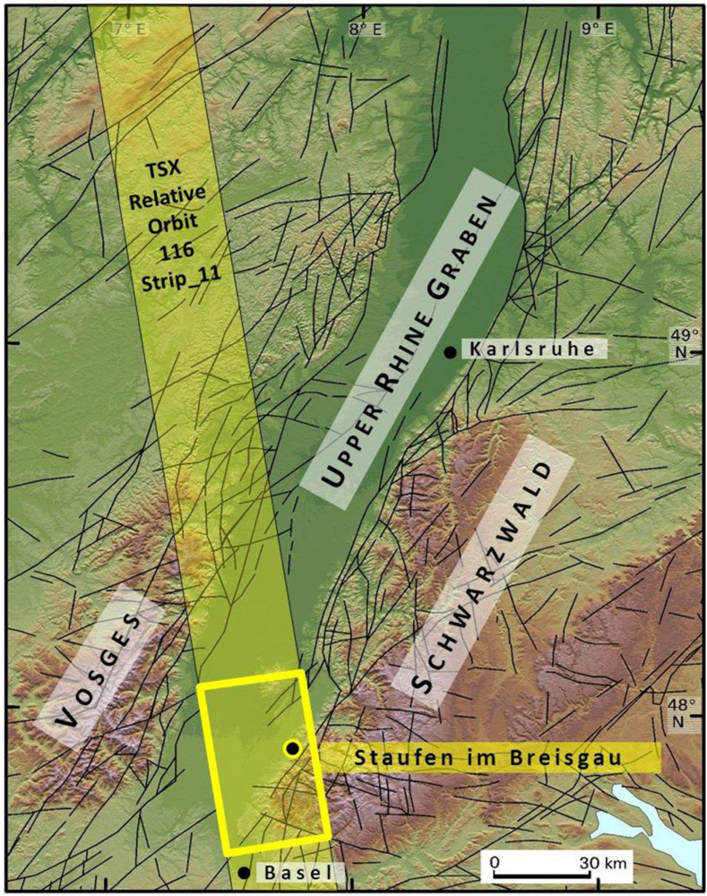
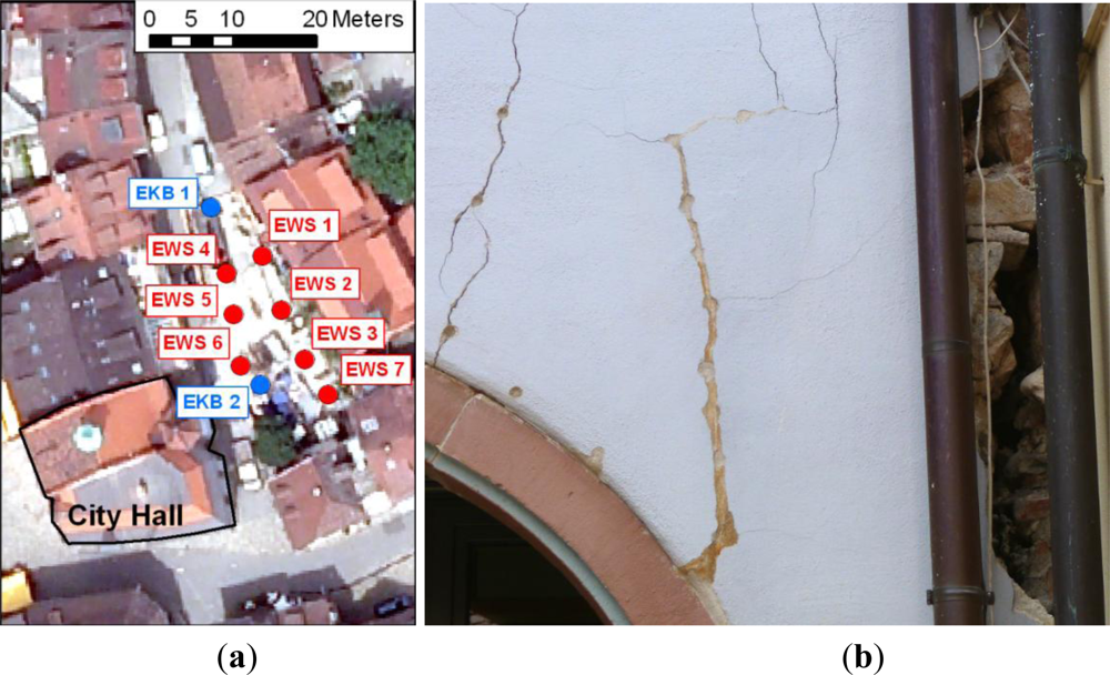
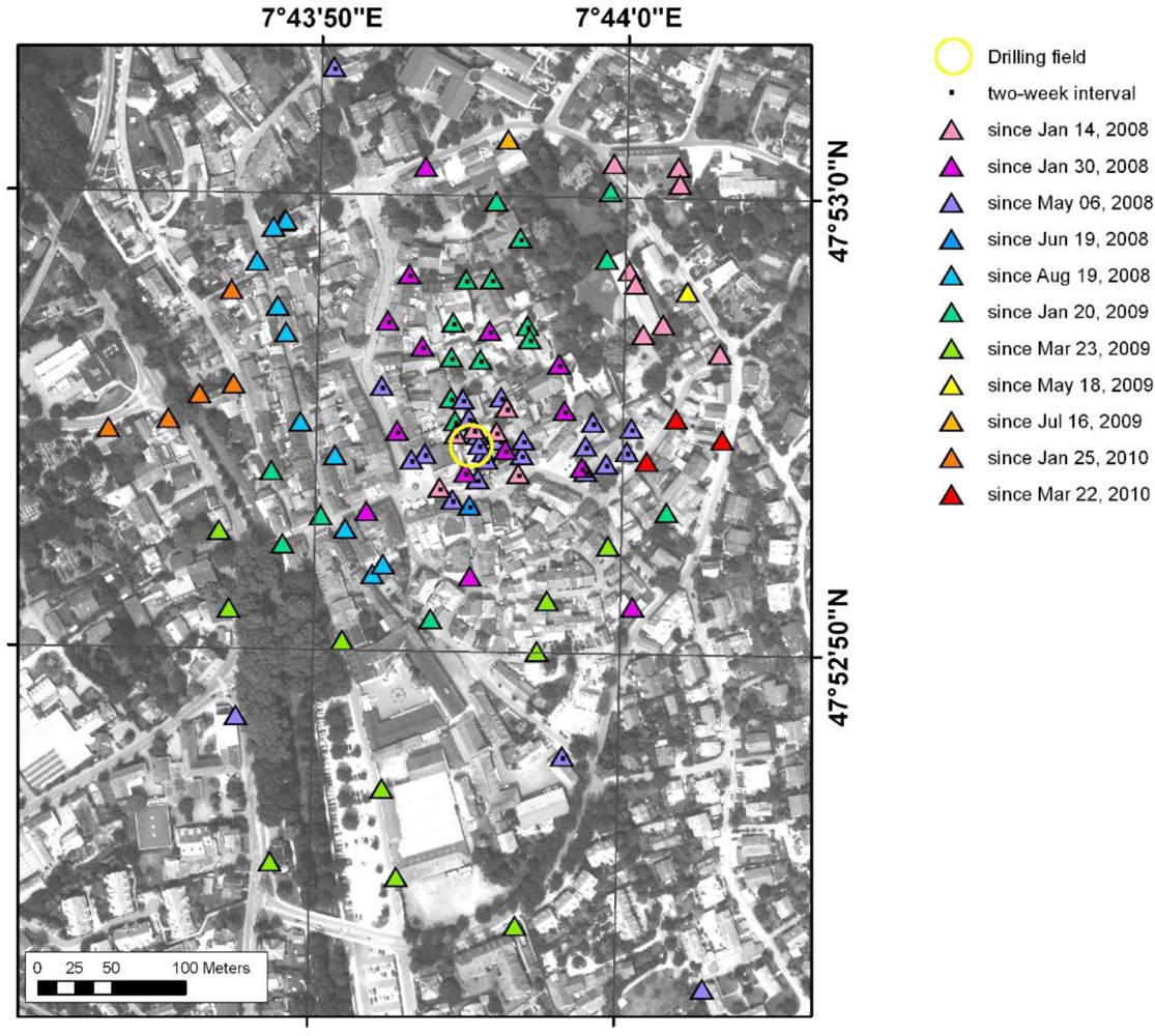
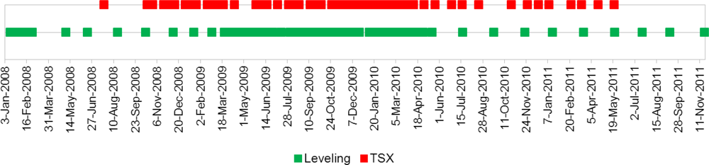
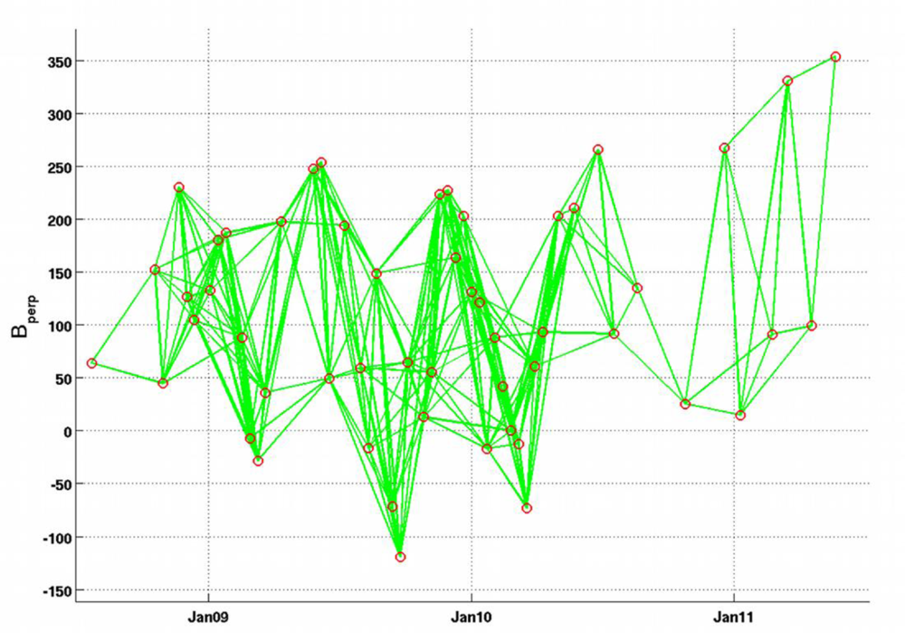
2. Data
3. Methodology
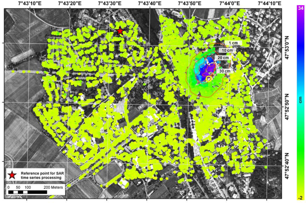
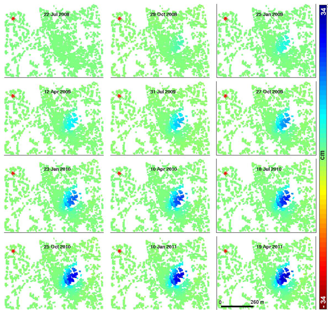
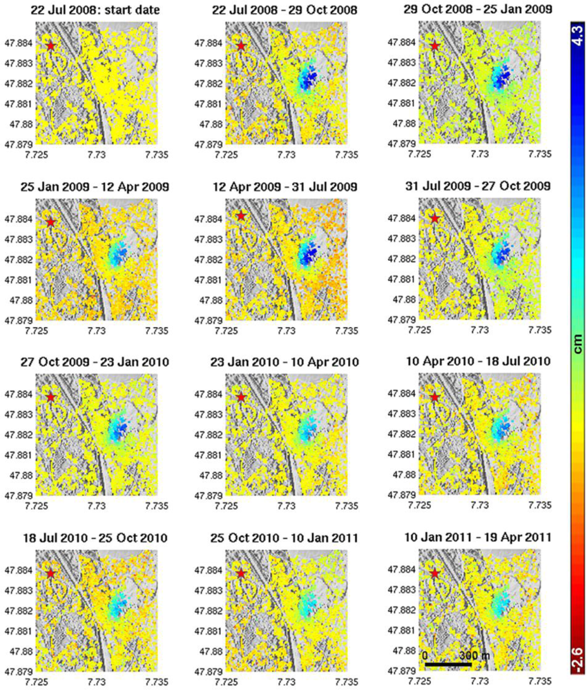
4. Results
5. Discussion
5.1. Leveling and InSAR Comparison
5.2. Implications of Horizontal Motion
5.3. Geological Considerations
6. Conclusion
Acknowledgments
- Conflict of InterestThe authors declare no conflict of interest.
References
- Illes, J.H. The Rhine graben rift system plate tectonics and transform faulting. Surv. Geophys 1972, 1, 27–60. [Google Scholar]
- Franzke, H.J.; Wetzel, H.U.; Werner, W. Welche Informationen können uns Fernerkundungsdaten zu Paläostressfeldern und zu Mineralisationsprozessen im Schwarzwald geben? Deutsche Gesellschaft Photogramm. Fernerkundung 2001, 9, 340–353. [Google Scholar]
- Franzke, H.J.; Werner, W.; Wetzel, H.U. Die Anwendung von Satellitenbilddaten zur tektonischen Analyse des Schwarzwalds und des angrenzenden Oberrheingrabens. Jb. Landesamt Geologie Rohstoffe Bergbau Baden Württemberg 2003, 41, 1–35. [Google Scholar]
- Münch, W.; Sistenich, H.P.; Bücker, C.; Blanke, T. Möglichkeiten der geothermischen Stromerzeugung im Oberrheingraben- Eine Analyse der geologischen Bedingungen, der Bohr- und Fördertechnik sowie der Kraftwerkstechnik und Wirtschaftlichkeit. VGB PowerTech. 2005, 10. [Google Scholar]
- LGRB Landesamt für Geologie Bergbau und Rohstoffe Baden-Württemberg. Geologische Untersuchungen von Baugrundhebungen im Bereich des Erdwärmesondenfeldes beim Rathaus in der historischen Altstadt von Staufen i. Br. Sachstandsbericht Az. 94-4763//10-563. 2010. Available online: http://www.lgrb.uni-freiburg.de/lgrb/home/schadensfall_staufen_bericht (accessed on 9 January 2012).
- Presseerklärung zu den Hebungsrissen. Presseerklärung vom 22.12.2011. Available online: http://www.staufen.de/aktuelles-nachrichten/hebungsrisse/presseerklaerungen/presseerklaerung-zu-den-hebungsrissen~1556/ (accessed on 27 March 2013).
- Stadt Staufen. zu den Hebungsrissen an den Gebäuden der historischen Altstadt von Staufen. Presseerklärung vom 09.04.2009. Available online: http://www.staufen.de/default.asp?pn=1030&dn=&p1=1&ln=0&nk=20 (accessed on 9 January 2012).
- Berardino, P.; Fornaro, G.; Lanari, R.; Sansosti, E. A new algorithm for surface deformation monitoring based on small baseline differential SAR interferograms. IEEE Trans. Geosci. Remote Sens 2002, 40, 2375–2383. [Google Scholar]
- Casu, F.; Manzo, M.; Lanari, R. A quantitative assessment of the SBAS algorithm performance for surface deformation retrieval from DInSAR data. Remote Sens. Environ 2006, 102, 195–210. [Google Scholar]
- Ferretti, A.; Prati, C; Rocca, F. Permanent scatterers in SAR interferometry. IEEE Trans. Geosci. Remote Sens 2001, 39, 8–20. [Google Scholar]
- Strozzi, T.; Teatini, P.; Tosi, L. TerraSAR-X reveals the impact of the mobile barrier works on Venice coastland stability. Remote Sens. Environ 2009, 113, 2682–2688. [Google Scholar]
- Anderssohn, J.; Motagh, M.; Walter, T.R.; Rosenau, M.; Kaufmann, H.; Oncken, O. Surface deformation time series and source modeling for a volcanic complex system based on satellite wide swath and image mode interferometry: The Lazufre system, central Andes. Remote Sens. Environ 2009, 113, 2062–2075. [Google Scholar]
- Lanari, R.; Lundgren, P.; Manzo, M.; Casu, F. Satellite radar interferometry time series analysis of surface deformation for Los Angeles, California. Geophys. Res. Lett 2004, 31, L23613. [Google Scholar]
- Motagh, M.; Hoffmann, J.; Kampes, B.; Baes, M.; Zschau, J. Strain accumulation across the Gazikoy-Saros segment of the North Anatolian Fault inferred from Persistent Scatterer Interferometry and GPS measurements. Earth Planet. Sci. Lett 2007, 255, 432–444. [Google Scholar]
- Vasco, D.W.; Rucci, A.; Ferretti, A.; Novali, F.; Bissell, R.C.; Ringrose, P.S.; Mathieson, A.S.; Wright, I.W. Satellite-based measurements of surface deformation reveal fluid flow associated with the geological storage of carbon dioxide. Geophys. Res. Lett 2010, 37, L03303. [Google Scholar]
- Sass, I.; Burbaum, U. Damage to the historic town of Staufen (Germany) caused by geothermal drillings through Anhydrite-Bearing formations. Acta Carsol 2010, 39, 233–245. [Google Scholar]
- Hooper, A. A multi-temporal InSAR method incorporating both persistent scatterer and small baseline approaches. Geophys. Res. Lett 2008, 35, L16302. [Google Scholar]
- Bell, J.W.; Amelung, F.; Ramelli, A.R.; Blewitt, G. Land subsidence in Las Vegas, Nevada, 1935–2000: New geodetic data show evolution, revised spatial patterns, and reduced rates. Environ. Eng. Geosci 2002, 8, 155–174. [Google Scholar]
- Fielding, E.J.; Blom, R.G.; Goldstein, R.M. Rapid subsidence over oil fields measured by SAR interferometry. Geophys. Res. Lett 1998, 25, 3215–3218. [Google Scholar]
- Galloway, D.L.; Hudnut, K.W.; Ingebritsen, S.E.; Philips, S.P.; Peltzer, G.; Rogez, F.; Rosen, P.A. Detection of aquifer system compaction and land subsidence using interferometric synthetic aperture radar, Antelope Valley, Mojave Desert, California. Water Resour. Res 1998, 34, 2573–2585. [Google Scholar]
- Motagh, M.; Walter, T.R.; Sharifi, M.A.; Fielding, E.; Schenk, A.; Anderssohn, J.; Zschau, J. Land subsidence in Iran caused by widespread water reservoir overexploitation. Geophys. Res. Lett 2008, 35, L16403. [Google Scholar]
- Rocca, F. Modeling Interferogram Stacks. IEEE Trans. Geosci. Remote Sens 2007, 45, 3289–3299. [Google Scholar]
- Kampes, B.M.; Hanssen, R.F.; Perski, Z. Radar Interferometry with Public Domain Tools. Proceeding of Third International Workshop on ERS SAR Interferometry, Frascati, Italy, 1–5 December 2003.
- Hooper, A. A Statistical-Cost Approach to Unwrapping the Phase of InSAR Time Series. Proceeding of International Workshop on ERS SAR Interferometry, Frascati, Italy, 30 November–4 December 2009.
- Hooper, A.; Zebker, H.; Segall, P.; Kampes, B. A new method for measuring deformation on volcanoes and other natural terrains using InSAR persistent scatterers. Geophys. Res. Lett 2004, 31, L23611. [Google Scholar]
- Hooper, A.; Segall, P.; Zebker, H. Persistent scatterer interferometric synthetic aperture radar for crustal deformation analysis with application to Volcan Alcedo, Galapagos. J. Geophys. Res.-Solid Earth 2007, 112, B07407. [Google Scholar]
- Stadt Staufen. Hebungsrisse: Runder Tisch vom 14.01.2013. Available online: http://www.staufen.de/aktuelles-nachrichten/hebungsrisse/protokolle-runder-tisch/hebungsrisse-runder-tisch~164881/ (accessed on 26 April 2013).
- LGRB Landesamt für Geologie Bergbau und Rohstoffe Baden-Württemberg. Zweiter Sachstandsbericht zu den seit dem 01.03.2010 erfolgten Untersuchungen im Bereich des Erdwärmesondenfeldes beim Rathaus in der historischen Altstadt von Staufen i. Br. 2012. Zweiter Sachstandsbericht Az. 94-4763//12-2487. Available online: http://www.lgrb.uni-freiburg.de/lgrb/home/schadensfall_staufen_bericht_2012 (accessed on 30 April 2013).
- Stadt Staufen. Presseerklärung vom 23.02.2012 zu den Hebungsrissen an den Gebäuden der historischen Altstadt von Staufen. Available Online: http://www.staufen.de/aktuelles-nachrichten/hebungsrisse/presseerklaerungen/presseerklaerung-zu-den-hebungsrissen~627 (accessed on 30 April 2013).
- Müller-Salzburg, L.; Götz, H.P. Heaving of invert in tunneling. Bull. Int. Assn. Eng. Geol 1975, 14, 51–53. [Google Scholar]
- Amelung, F.; Galloway, D.L.; Bell, J.W.; Zebker, H.A.; Laczniak, R.J. Sensing the ups and downs of Las Vegas: InSAR reveals structural control of land subsidence and aquifer-system deformation. Geology 1999, 27, 483–486. [Google Scholar]
- Motagh, M.; Djamour, Y.; Walter, T.R.; Wetzel, H.U.; Zschau, J.; Arabi, S. Land subsidence in Mashhad Valley, northeast Iran: Results from InSAR, leveling and GPS. Geophys. J. Int 2007, 168, 518–526. [Google Scholar]
- Stadt Staufen. Presseerklärung vom 12.11.2009 und 17.12.2009 zu den Hebungsrissen an den Gebäuden der historischen Altstadt von Staufen. Available Online: http://www.staufen.de/default.asp?pn=1030&dn=&p1=1&ln=0&nk=20 (accessed on 9 January 2012).
- Zabank, C.; Arthur, R.C. Rock Mechanics Aspects of Volume Changes in Calcium Sulfate Bearing Rocks due to Geochemical Phase Transitions. Proceeding of The 25th US Symposium on Rock Mechanics (USRMS), Evanston, IL, USA, 25 June 1984.
- Pando, L.; Pulgar, J.A.; Gutiérrez-Claverol, M. A case of man-induced ground subsidence and building settlement related to karstified gypsum (Oviedo, NW Spain). Environ. Earth Sci 2013, 68, 507–519. [Google Scholar]


© 2013 by the authors; licensee MDPI, Basel, Switzerland This article is an open access article distributed under the terms and conditions of the Creative Commons Attribution license (http://creativecommons.org/licenses/by/3.0/).
Share and Cite
Lubitz, C.; Motagh, M.; Wetzel, H.-U.; Kaufmann, H. Remarkable Urban Uplift in Staufen im Breisgau, Germany: Observations from TerraSAR-X InSAR and Leveling from 2008 to 2011. Remote Sens. 2013, 5, 3082-3100. https://doi.org/10.3390/rs5063082
Lubitz C, Motagh M, Wetzel H-U, Kaufmann H. Remarkable Urban Uplift in Staufen im Breisgau, Germany: Observations from TerraSAR-X InSAR and Leveling from 2008 to 2011. Remote Sensing. 2013; 5(6):3082-3100. https://doi.org/10.3390/rs5063082
Chicago/Turabian StyleLubitz, Christin, Mahdi Motagh, Hans-Ulrich Wetzel, and Hermann Kaufmann. 2013. "Remarkable Urban Uplift in Staufen im Breisgau, Germany: Observations from TerraSAR-X InSAR and Leveling from 2008 to 2011" Remote Sensing 5, no. 6: 3082-3100. https://doi.org/10.3390/rs5063082
APA StyleLubitz, C., Motagh, M., Wetzel, H.-U., & Kaufmann, H. (2013). Remarkable Urban Uplift in Staufen im Breisgau, Germany: Observations from TerraSAR-X InSAR and Leveling from 2008 to 2011. Remote Sensing, 5(6), 3082-3100. https://doi.org/10.3390/rs5063082