1. Introduction
Information on the variability of soil properties leads to an increased ability to monitor key physical and chemical processes, with agronomic and environmental management implications. In particular, soil texture is a key agro-ecosystem variable whose estimation is essential for a full knowledge of the potential of soils in terms of fertility and water holding capacity. For instance, the knowledge of soil texture variability is central for the implementation of site-specific farming management strategies that allow for a more efficient use of resources, such as water and fertilizers; therefore reducing costs and environmental impact.
Soil spectroscopy in the visible-near infrared (VNIR: 400–1300 nm) and short-wave infrared (SWIR: 1300–2500 nm) domains has proven to be a non-destructive, reproducible, and accurate analytical technique for the quantitative estimation of soil variables [
1]. The spectral composition of energy reflected or emitted from the topsoil depends on the organic and mineral soil composition, the soil moisture content, and the optical-geometric scattering. The most important factors influencing the scattering effect are both the particle size and roughness. In the soil spectroscopy context, some soil variables have a direct spectral response, e.g., having typical absorption features related to chemical components [
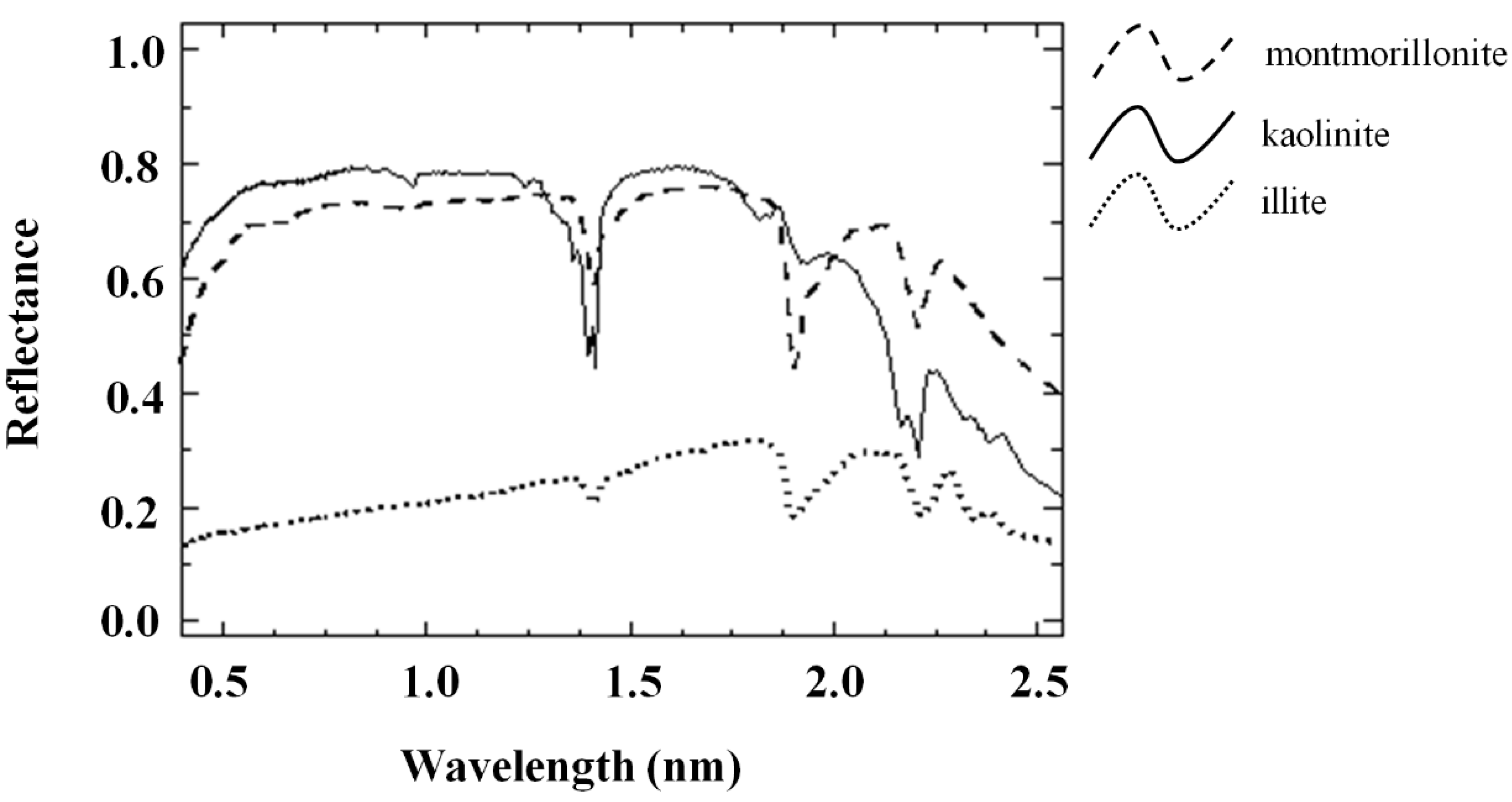
2]. The main chemical components, or chromophores, interacting with visible and infrared radiations are water, organic matter, clay minerals, iron oxides, carbonates, and salts. These are related to well-defined absorption features [
2], typically associated with overtones of functional groups in the VNIR and especially in the SWIR spectral ranges. In particular, free water absorption features are detected at 1455 and 1915 nm that are caused by overtones of o-h and h-o-h stretch vibrations, while metal-OH bends and O-H stretch related to clay lattice both affect the absorption peaks centered at about 1415 and 2207 nm. Hyperspectral imagers allow the measurement of spectral reflectance for hundreds of narrow bands, thus being an attractive tool that can be used for estimating soil variables. The fine spectral resolution of hyperspectral imagers allows for distinguishing the spectral features related to the chromophores. Published research in which hyperspectral satellite data has been used to estimate soil variables is, however, still very rare since currently only the Hyperion satellite hyperspectral imager on board of NASA EO-1 is available for soil studies. Four satellites carrying hyperspectral imagers, operating in the VNIR-SWIR spectral range, are due to be launched in the near future: the German EnMap (Environmental Mapping and Analysis Program) [
3], the Japanese HISUI (Hyperspectral Imager Suite) [
4], the Italian PRISMA (PRecursore IperSpettrale della Missione Applicativa) [
5], and the U.S. NASA HyspIRI (Hyperspectral Infrared Imager) [
6]. In particular, PRISMA, due to be launched in 2018, is a mission of the Italian Space Agency (ASI), which combines a hyperspectral imager with a panchromatic, medium-resolution camera that will have the capability to collect 240 spectral bands in the wavelength range 400–2450 nm (VNIR-SWIR spectral ranges).
The use of hyperspectral remote sensing data for the estimation of soil variables is hampered by the need to acquire data on bare soil conditions and by the characteristics of existing satellite sensors,
i.e., the spectral and spatial resolution and the signal quality in the spectral regions affected by absorption peaks of the main soil variables [
7]. Moreover, surface spectral data are also generally affected by the confounding effects of soil moisture and soil roughness. Soil moisture determines a reduction of the reflectance over the entire spectrum, because it has a strong influence on the amount and composition of reflected and emitted energy from the soil surface. This decrease in reflectance related to soil moisture is not linear and its magnitude varies depending on the spectral region and the soil type [
7]. In particular, the strength of the most important absorption features related to the estimation of soil variables, such as clay, are greatly reduced with increasing levels of moisture [
7,
8,
9,
10]. For these reasons, soil moisture could be a limiting factor for the estimation of soil properties if its effects are not taken into account in the estimation models. Therefore, the
a priori knowledge of soil moisture content, at the time of remote sensing imagery acquisition, could improve its estimation accuracy [
9]. Many researchers have studied the influence of soil moisture on soil reflectance, but only a few have actually investigated the consequences of this factor on soil variable estimation, and particularly on clay content prediction [
11,
12,
13]. In many cases, studies were only carried out in laboratory conditions [
7,
9,
14,
15,
16]. The first derivative of soil spectra was used to understand the impact of variable soil moisture on soil organic carbon (SOC) prediction [
10]. Specific prediction models were developed on soil samples having similar soil moisture contents, thereby obtaining a consistent improvement on SOC estimation accuracy [
9]. This suggests that the
a priori knowledge of soil moisture could improve the estimation accuracy of soil variables. Alternatively, the reduction of moisture effects was successfully obtained in spectra acquired in field conditions by [
17] using a direct standardization (DS) of the spectra, using a technique called external parameter orthogonalization (EPO). This resulted in an improved prediction of clay and organic matter content from soils with unknown soil moisture content [
12,
13].
Satellite hyperspectral imagers have been employed to estimate soil moisture, in bare soil conditions, by using narrow band indices [
18]. However, the low signal to noise ratio (SNR) in the SWIR band of the hyperspectral satellite sensors currently in operation (e.g., Hyperion) hampers the accuracy of the estimation. Therefore, the issue of soil moisture influence on clay estimation has been explored in this work, through the use of simulated satellite data.
Multivariate or hybrid techniques, such as PLSR (partial least squares regression), principal component regression, or regression-kriging, generally provide accurate estimations [
19,
20,
21]. However, these techniques require extensive ground data, laboratory analyses, and spectral measurements and provide only local models, which cannot be applied to different conditions or areas. The different sensor characteristics (e.g., bandwidths, number of bands, wavelength position) make it necessary to perform a new calibration for each sensor [
22] or even images acquired under different illumination and geometry of observation. Instead, the development of spectral indices using soil spectra collected in laboratory conditions would allow for obtaining more general models, albeit less accurate than multivariate models [
22].
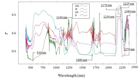
The objective of this work was to derive narrow band clay indices for the estimation of soil moisture and clay, developing a methodology to reduce the effect of soil moisture on clay estimation. As a reference, results obtained with spectral clay indices were compared to those from PLSR models. To our knowledge, no previous research has investigated the possibility of estimating clay using narrow band spectral indices from realistically simulated satellite spectra.
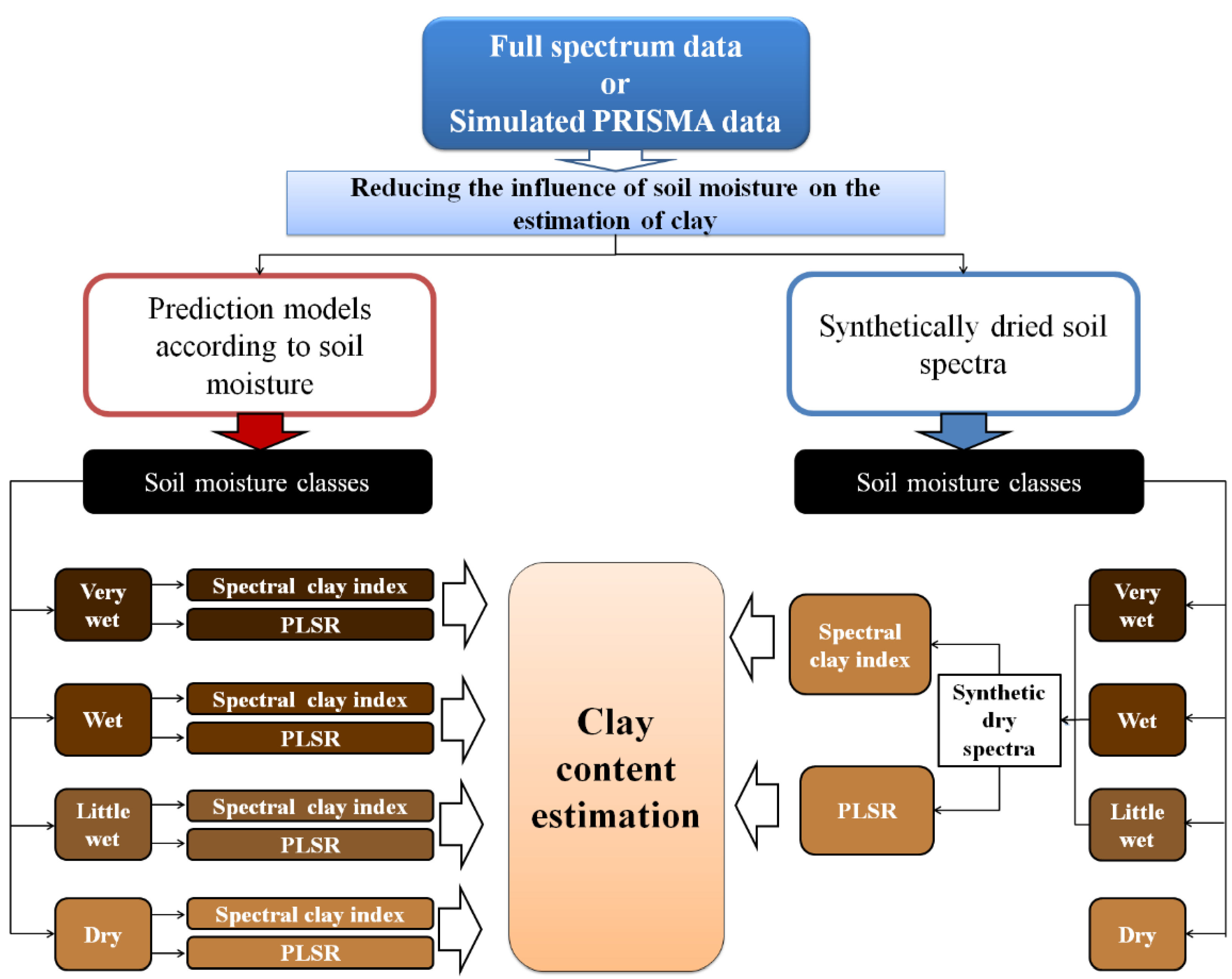
Since the prediction of soil clay content from satellite images could be significantly improved by the estimation of soil moisture at acquisition time, we developed two different approaches to reduce the effects of soil moisture. The first approach is based on the calibration of clay indices selected according to different soil moisture levels, whereas in the second approach, equivalent dry soil spectra (hereafter referred to as synthetically dried) are reconstructed from the spectra of wet soil samples and then used in clay estimation models. Both approaches were developed and tested, using spectral datasets acquired under laboratory conditions. In order to verify the feasibility of the two approaches for hyperspectral satellite data, both methodologies were also applied to simulated PRISMA data.
4. Conclusions
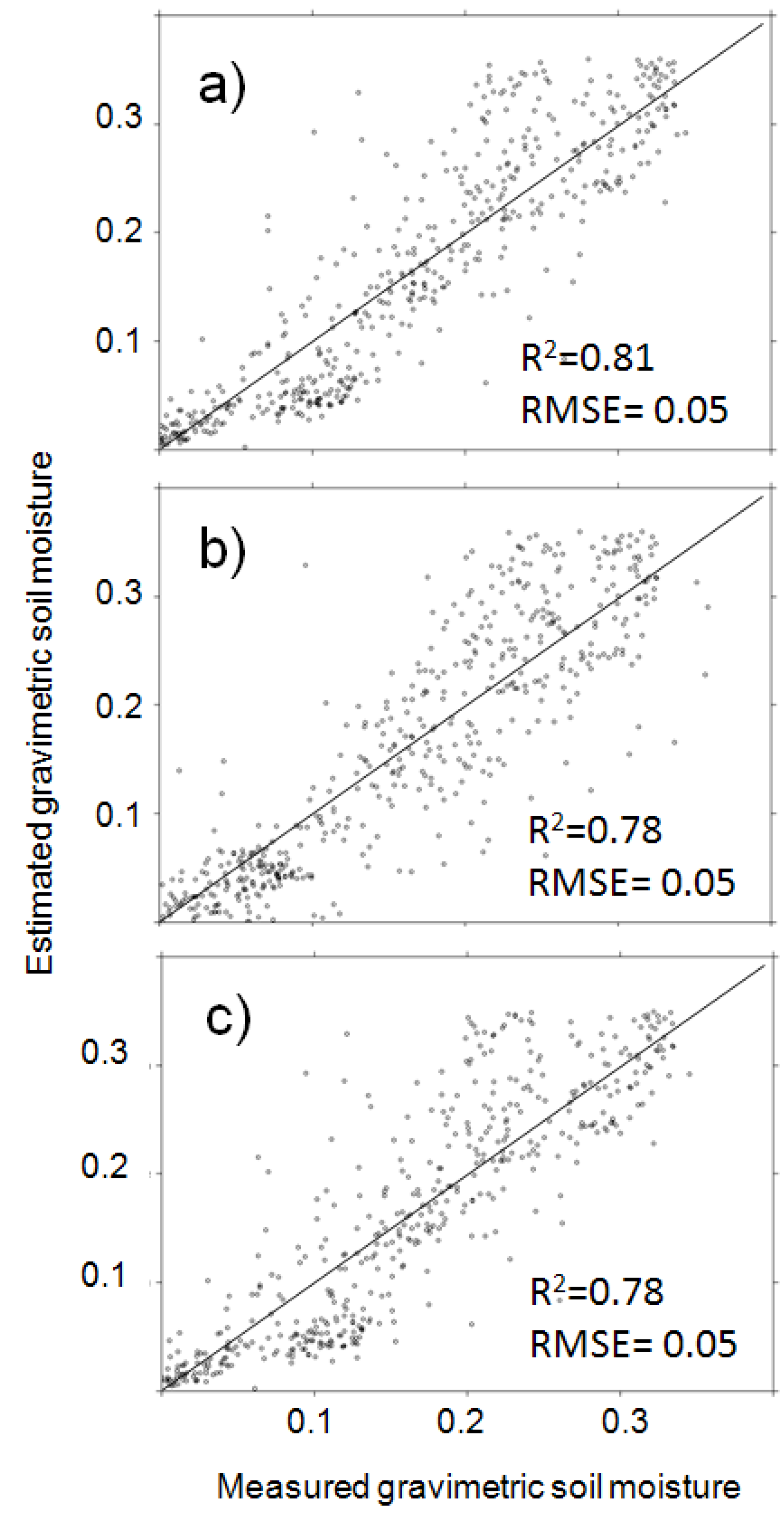
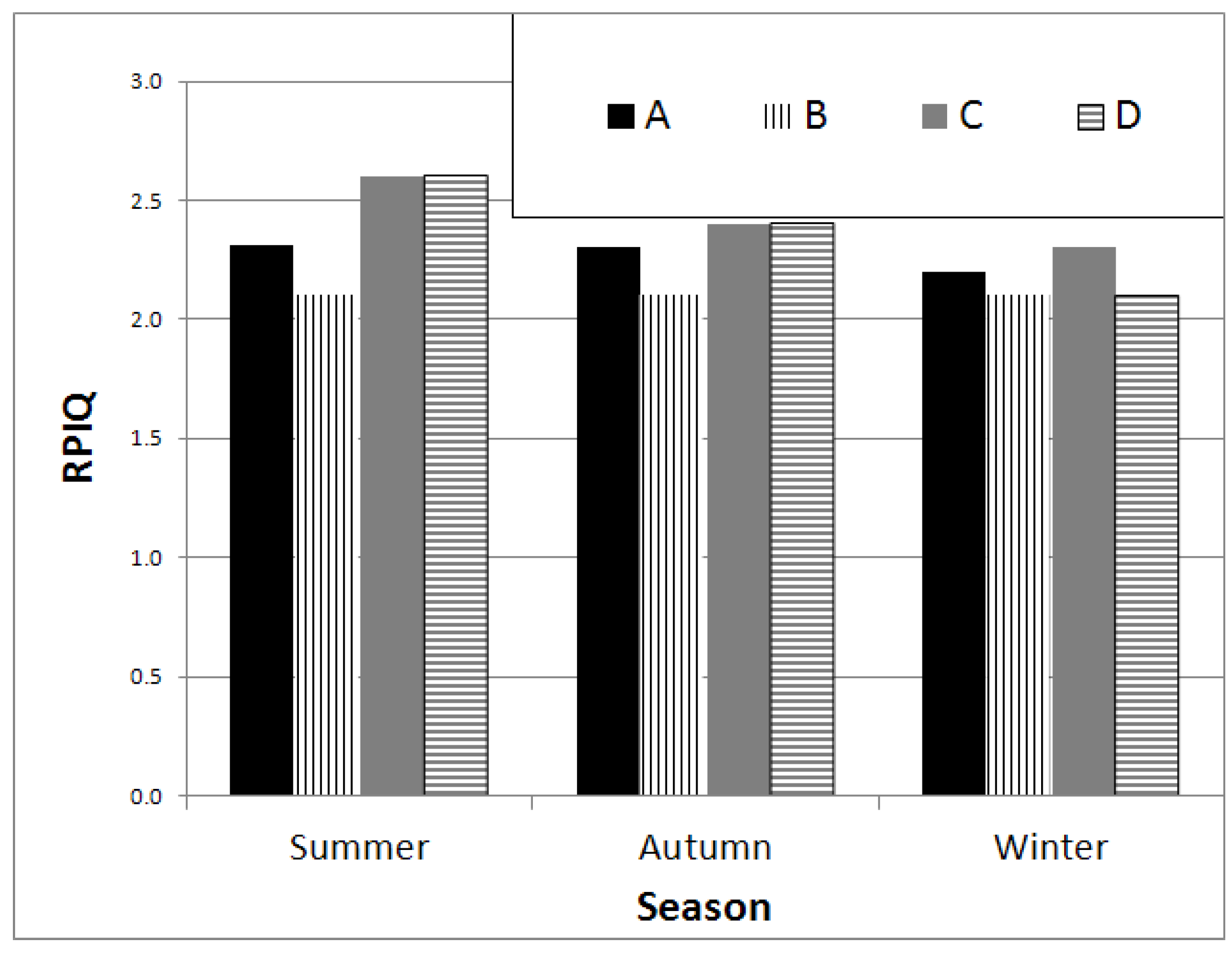
The results obtained in this study confirm that the a priori knowledge of soil moisture can significantly reduce the estimation error of clay using hyperspectral data. The use of narrow band clay indices according to soil moisture is a novel approach potentially of interest for proximal and remote sensing applications. In order to apply clay indices, precise quantitative information on soil moisture might not be required, since it will be sufficient to assign data to a rather broad soil moisture class: for instance we used classes with a 10% soil moisture range. Therefore, the use of clay indices appears to be very attractive when applied to hyperspectral data provided by satellite (remote sensing) or on-the-go sensors (proximal sensing).
The two approaches tested to reduce the influence of soil moisture, i.e., the use of different prediction models according to soil moisture content or the use of models calibrated by using synthetically dried soil spectra data set, were both effective in improving clay content retrieval, both using narrow band clay indices and PLSR models. The estimation of clay when using different prediction models according to soil moisture was, however, slightly more accurate as compared to the use of synthetically dry spectra, both employing clay indices (mean RMSE = 6.7%; mean RPIQ = 2.52) and PLSR models (mean RMSE = 5%; mean RPIQ = 3.37). Even though the spectral clay indices showed lower estimation accuracy than PLSR, indices generally ensure a higher adaptability to different soil conditions, being based on the specific spectral absorption features of the clays.
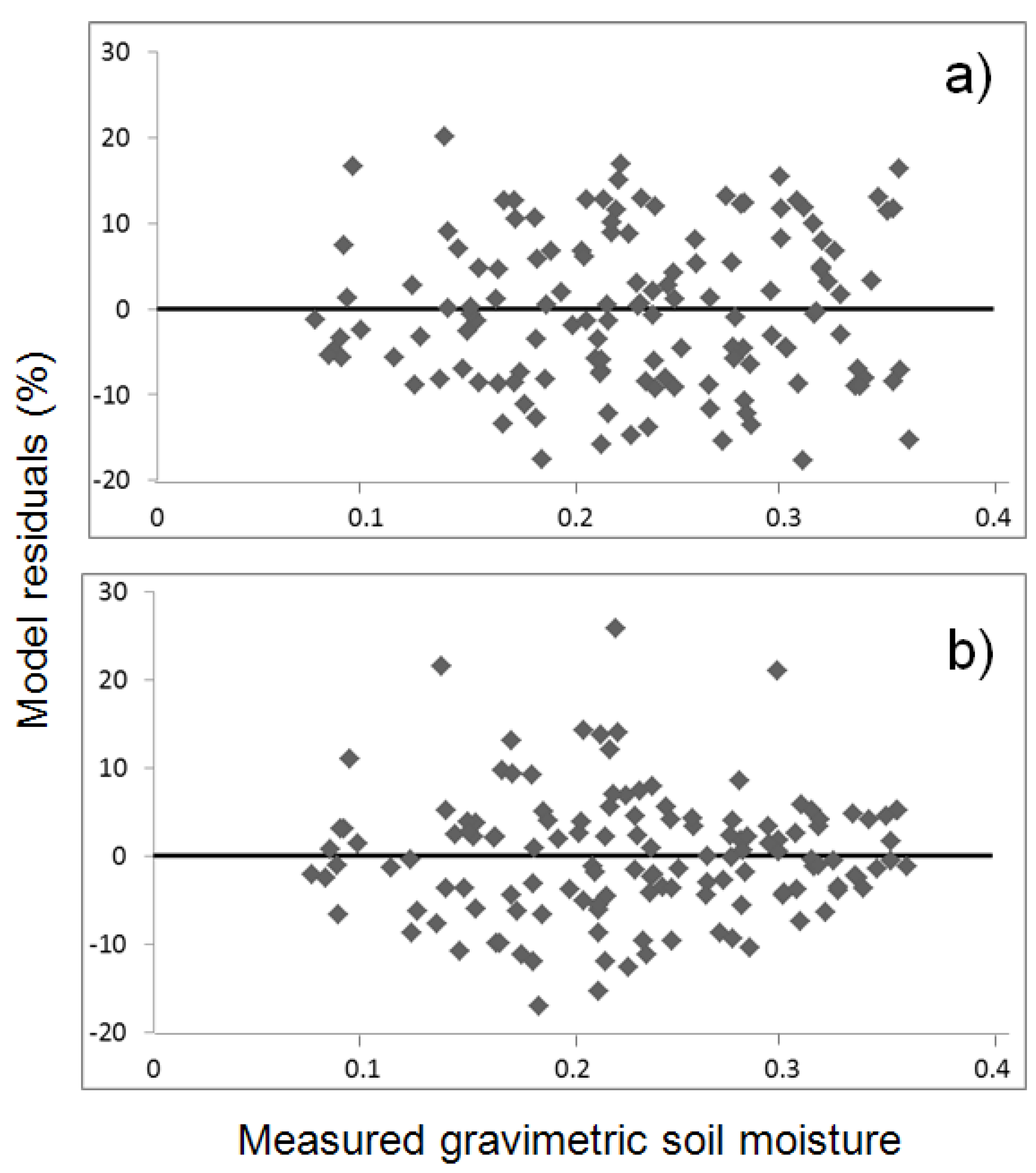
The use of simulated PRISMA data brought about a decrease in soil clay content estimation accuracy as compared with the full spectral datasets data, both for indices (mean RMSE = 7.3%; mean RPIQ = 2.3) and PLSR (mean RMSE = 6.9%; mean RPIQ = 2.6) models. The a priori knowledge of soil moisture, for the selection the optimal clay index on the basis of the soil moisture class, decreased by 27% the RMSE values and increased the clay content estimation accuracy by using lab soil datasets.
The estimation accuracy of soil moisture content, as well as that of clay, is mainly affected by the SWIR spectral region and this is particularly evident around the water absorption features. Thus, in order to obtain acceptable estimation accuracies of soil variables from hyperspectral remote sensing data, high SNR values in the SWIR region are required.
Although the process that we used to obtain simulated PRISMA data was rigorous, taking into account the sensor signal to noise ratio and different atmospheric effects, the different techniques proposed here should be tested on real hyperspectral satellite data with similar performances in real field conditions, in which, for instance, soil roughness or the presence of crop residues would add further errors.


 ,
, 


