Comparison of Methods for Estimating Fractional Cover of Photosynthetic and Non-Photosynthetic Vegetation in the Otindag Sandy Land Using GF-1 Wide-Field View Data
Abstract
:1. Introduction
2. Materials and Methods
2.1. Study Area
2.2. Data Used in this Study
2.2.1. Remote Sensing Data
2.2.2. Field Spectroscopy
2.2.3. Fractional Ground Cover Data
2.3. Methods
2.3.1. Spectral Mixture Analysis
2.3.2. Multiple Endmember SMA
2.3.3. AutoMCU
2.3.4. Unmixing Strategy
2.3.5. Comparison with Observed Data
3. Results
3.1. Field fpv fnpv, and fsoil Measurements
3.2. Endmember Library and Variability
3.3. Fractional Cover Estimation and Validation
3.3.1. SMA
3.3.2. MESMA
3.3.3. AutoMCU
3.3.4. Comparisons of Different Methods
4. Discussion
4.1. Separability of NPV and Bare Soil in SMA
4.2. Effects of Endmember Variability
4.3. Cross-Multispectral Sensor Comparison
4.4. Uncertainties, and Sources of Error
5. Conclusions
- (1)
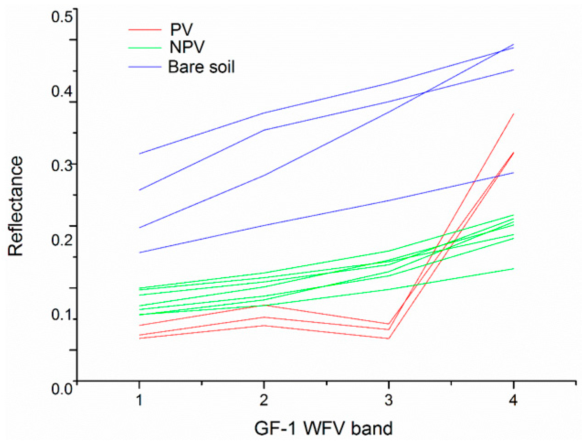
- Despite spectral similarity of NPV and bare soil, there are some differences in the GF-1 WFV bands. First and foremost, the bare soil spectra are significantly higher than the NPV spectra, mainly due to extensive bright sandy substrate. In addition, a bow-shaped protuberance exists from blue to red bands in the bare soil spectra, which is not present in the NPV spectra.
- (2)
- Due to the complex and bright soil background of the Otindag Sandy Land, the bare soil endmember libraries show large intra-variability. Therefore, determining the appropriate endmember combinations, especially the bare soil endmember, is a key process for successfully estimating fpv and fnpv.
- (3)
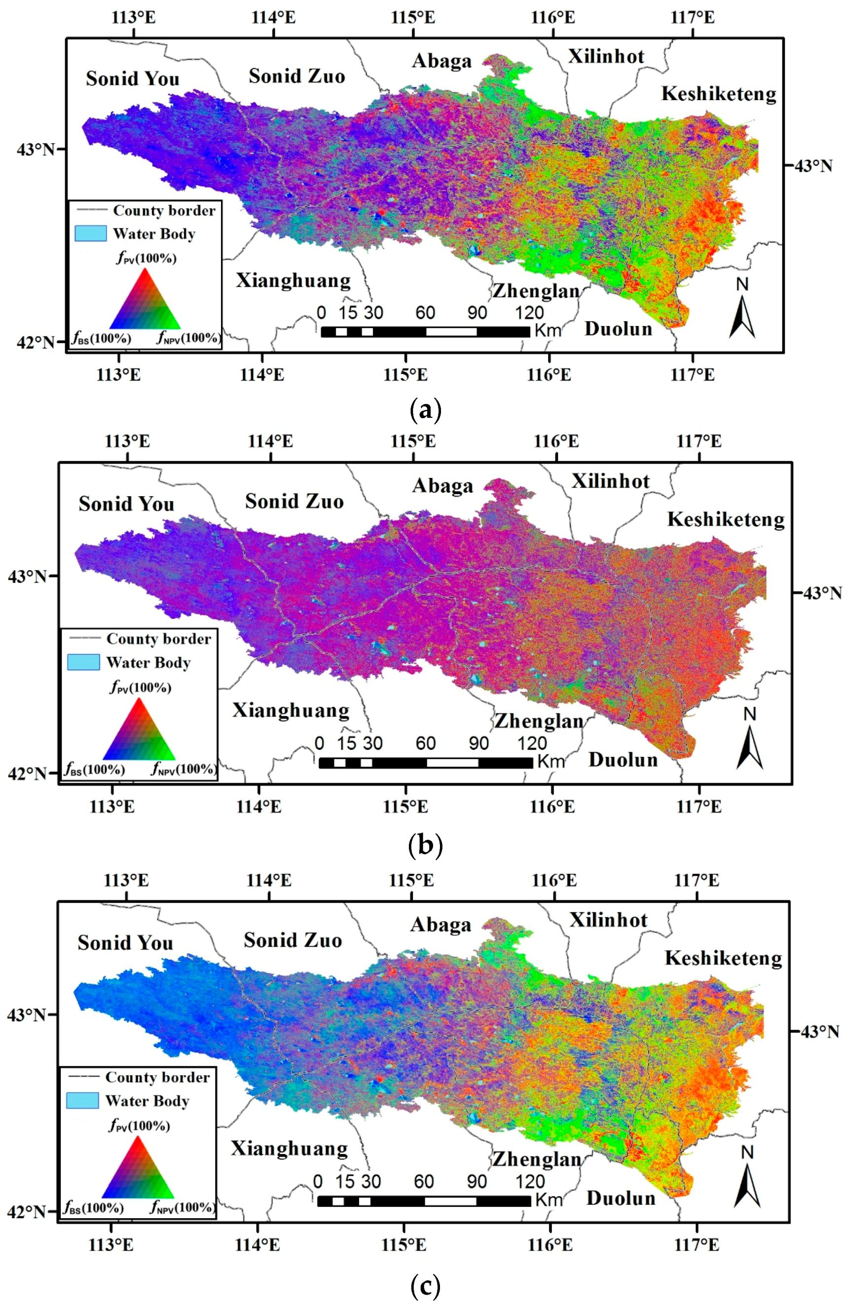
- Invariant endmember combinations should be used with caution, because they can lead to serious over- or underestimation problems (SMA). The MESMA cannot be assumed to always perform better than SMA, due to the coupling of the NPV and bare soil endmembers. AutoMCU was shown to be effective for dealing with endmember variability while acquiring accurate fpv and fnpv estimation. Compared with SMA, both R2 and RMSE are improved.
- (4)
- Compared to other relevant multispectral applications, the GF-1 WFV data were shown to be capable for fpv and fnpv estimation in the Otindag Sandy Land, despite a lack of the important SWIR bands, which are considered important for separation of NPV from bare soil. With GF-1 WFV’s unique advantage of high spatial resolution (16 m), wide coverage (800 km), and high revisit frequency (2–3 days), there is great potential for future analyses.
Acknowledgments
Author Contributions
Conflicts of Interest
References
- Ruiz-Colmenero, M.; Bienes, R.; Eldridge, D.; Marques, M. Vegetation cover reduces erosion and enhances soil organic carbon in a vineyard in the central Spain. Catena 2013, 104, 153–160. [Google Scholar] [CrossRef]
- Higginbottom, T.P.; Symeonakis, E. Assessing land degradation and desertification using vegetation index data: Current frameworks and future directions. Remote Sens. 2014, 6, 9552–9575. [Google Scholar] [CrossRef]
- Asner, G.P.; Heidebrecht, K.B. Imaging spectroscopy for desertification studies: Comparing aviris and eo-1 hyperion in argentina drylands. IEEE Trans. Geosci. Remote Sens. 2003, 41, 1283–1296. [Google Scholar] [CrossRef]
- Bastin, G.; Scarth, P.; Chewings, V.; Sparrow, A.; Denham, R.; Schmidt, M.; O’Reagain, P.; Shepherd, R.; Abbott, B. Separating grazing and rainfall effects at regional scale using remote sensing imagery: A dynamic reference-cover method. Remote Sens. Environ. 2012, 121, 443–457. [Google Scholar] [CrossRef]
- Haijiang, L.; Chenghu, Z.; Weiming, C.; En, L.; Rui, L. Monitoring sandy desertification of otindag sandy land based on multi-date remote sensing images. Acta Ecol. Sin. 2008, 28, 627–635. [Google Scholar] [CrossRef]
- Wu, B.; Li, X.; Liu, W.; Yang, X.; Lu, Q. Desertification control regionalization and rehabilitation counter meatures of source area of sand and dust endangering Beijing–Tianjin. Scientia Silave Sinicae 2006, 42, 65–70. [Google Scholar]
- Wu, Z.; Wu, J.; Liu, J.; He, B.; Lei, T.; Wang, Q. Increasing terrestrial vegetation activity of ecological restoration program in the Beijing–Tianjin sand source region of China. Ecol. Eng. 2013, 52, 37–50. [Google Scholar] [CrossRef]
- Li, X.; Zhang, J. Derivation of the green vegetation fraction of the whole China from 2000 to 2010 from MODIS data. Earth Interact. 2016, 20, 1–16. [Google Scholar] [CrossRef]
- Jiang, Z.; Huete, A.R.; Chen, J.; Chen, Y.; Li, J.; Yan, G.; Zhang, X. Analysis of NDVI and scaled difference vegetation index retrievals of vegetation fraction. Remote Sens. Environ. 2006, 101, 366–378. [Google Scholar] [CrossRef]
- Gitelson, A.A.; Kaufman, Y.J.; Stark, R.; Rundquist, D. Novel algorithms for remote estimation of vegetation fraction. Remote Sens. Environ. 2002, 80, 76–87. [Google Scholar] [CrossRef]
- Tucker, C.J. Red and photographic infrared linear combinations for monitoring vegetation. Remote Sens. Environ. 1979, 8, 127–150. [Google Scholar] [CrossRef]
- Huete, A.; Didan, K.; Miura, T.; Rodriguez, E.P.; Gao, X.; Ferreira, L.G. Overview of the radiometric and biophysical performance of the MODIS vegetation indices. Remote Sens. Environ. 2002, 83, 195–213. [Google Scholar] [CrossRef]
- Okin, G.S. The contribution of brown vegetation to vegetation dynamics. Ecology 2010, 91, 743–755. [Google Scholar] [CrossRef] [PubMed]
- Guerschman, J.P.; Hill, M.J.; Renzullo, L.J.; Barrett, D.J.; Marks, A.S.; Botha, E.J. Estimating fractional cover of photosynthetic vegetation, non-photosynthetic vegetation and bare soil in the Australian tropical savanna region upscaling the eo-1 hyperion and MODIS sensors. Remote Sens. Environ. 2009, 113, 928–945. [Google Scholar] [CrossRef]
- Elmore, A.J.; Asner, G.P.; Hughes, R.F. Satellite monitoring of vegetation phenology and fire fuel conditions in Hawaiian Drylands. Earth Interact. 2005, 9, 1–21. [Google Scholar] [CrossRef]
- Okin, G.S. Relative spectral mixture analysis—A multitemporal index of total vegetation cover. Remote Sens. Environ. 2007, 106, 467–479. [Google Scholar] [CrossRef]
- Aguilar, J.; Evans, R.; Daughtry, C. Performance assessment of the cellulose absorption index method for estimating crop residue cover. J. Soil Water Conserv. 2012, 67, 202–210. [Google Scholar] [CrossRef]
- Daughtry, C.S.; Doraiswamy, P.; Hunt, E., Jr.; Stern, A.; McMurtrey, J., III; Prueger, J. Remote sensing of crop residue cover and soil tillage intensity. Soil Tillage Res. 2006, 91, 101–108. [Google Scholar] [CrossRef]
- Ren, H.; Zhou, G.; Zhang, F.; Zhang, X. Evaluating cellulose absorption index (CAI) for non-photosynthetic biomass estimation in the desert steppe of Inner Mongolia. Chin. Sci. Bull. 2012, 57, 1716–1722. [Google Scholar] [CrossRef]
- Jia, G.J.; Burke, I.C.; Goetz, A.F.; Kaufmann, M.R.; Kindel, B.C. Assessing spatial patterns of forest fuel using AVIRIS data. Remote Sens. Environ. 2006, 102, 318–327. [Google Scholar] [CrossRef]
- Huete, A.R.; Miura, T.; Gao, X. Land cover conversion and degradation analyses through coupled soil-plant biophysical parameters derived from hyperspectral EO-1 hyperion. IEEE Trans. Geosci. Remote Sens. 2003, 41, 1268–1276. [Google Scholar] [CrossRef]
- Qi, J.; Wallace, O. Biophysical attributes estimation from satellite images in arid regions. In Proceedings of the 2002 IEEE International Geoscience and Remote Sensing Symposium (IGARSS’02), Toronto, ON, Canada, 24–28 June 2002; pp. 2000–2002.
- Marsett, R.C.; Qi, J.; Heilman, P.; Biedenbender, S.H.; Watson, M.C.; Amer, S.; Weltz, M.; Goodrich, D.; Marsett, R. Remote sensing for grassland management in the arid southwest. Rangel. Ecol. Manag. 2006, 59, 530–540. [Google Scholar] [CrossRef]
- Cao, X.; Chen, J.; Matsushita, B.; Imura, H. Developing a MODIS-based index to discriminate dead fuel from photosynthetic vegetation and soil background in the asian steppe area. Int. J. Remote Sens. 2010, 31, 1589–1604. [Google Scholar] [CrossRef]
- Asner, G.P.; Heidebrecht, K.B. Spectral unmixing of vegetation, soil and dry carbon cover in arid regions: Comparing multispectral and hyperspectral observations. Int. J. Remote Sens. 2002, 23, 3939–3958. [Google Scholar] [CrossRef]
- Okin, G.S.; Clarke, K.D.; Lewis, M.M. Comparison of methods for estimation of absolute vegetation and soil fractional cover using MODIS normalized BRDF-adjusted reflectance data. Remote Sens. Environ. 2013, 130, 266–279. [Google Scholar] [CrossRef]
- Muir, J. Field Measurement of Fractional Ground Cover: A Technical Handbook Supporting Ground Cover Monitoring for Australia; ABARES: Canberra, Australia, 2011.
- Roberts, D.A.; Gardner, M.; Church, R.; Ustin, S.; Scheer, G.; Green, R. Mapping chaparral in the Santa Monica Mountains using multiple endmember spectral mixture models. Remote Sens. Environ. 1998, 65, 267–279. [Google Scholar] [CrossRef]
- Asner, G.P.; Lobell, D.B. A biogeophysical approach for automated SWIR unmixing of soils and vegetation. Remote Sens. Environ. 2000, 74, 99–112. [Google Scholar] [CrossRef]
- Heinz, D.C.; Chang, C.-I. Fully constrained least squares linear spectral mixture analysis method for material quantification in hyperspectral imagery. IEEE Trans. Geosci. Remote Sens. 2001, 39, 529–545. [Google Scholar] [CrossRef]
- Chang, C.-I.; Heinz, D.C. Constrained subpixel target detection for remotely sensed imagery. IEEE Trans. Geosci. Remote Sens. 2000, 38, 1144–1159. [Google Scholar] [CrossRef]
- Gao, Z.; Bai, L.; Wang, B.; Li, Z.; Li, X.; Wang, Y. Estimation of soil organic matter content in desertified lands using measured soil spectral data. Scientia Silvae Sinicae 2011, 47, 9–16. [Google Scholar]
- Numata, I.; Roberts, D.A.; Chadwick, O.A.; Schimel, J.; Sampaio, F.R.; Leonidas, F.C.; Soares, J.V. Characterization of pasture biophysical properties and the impact of grazing intensity using remotely sensed data. Remote Sens. Environ. 2007, 109, 314–327. [Google Scholar] [CrossRef]
- Ballantine, J.-A.C.; Okin, G.S.; Prentiss, D.E.; Roberts, D.A. Mapping north african landforms using continental scale unmixing of MODIS imagery. Remote Sens. Environ. 2005, 97, 470–483. [Google Scholar] [CrossRef]
- Mishra, N.B.; Crews, K.A. Estimating fractional land cover in semi-arid central kalahari: The impact of mapping method (spectral unmixing vs. Object-based image analysis) and vegetation morphology. Geocarto Int. 2014, 29, 860–877. [Google Scholar] [CrossRef]
- Okin, G.S.; Roberts, D.A.; Murray, B.; Okin, W.J. Practical limits on hyperspectral vegetation discrimination in arid and semiarid environments. Remote Sens. Environ. 2001, 77, 212–225. [Google Scholar] [CrossRef]
- Davidson, E.A.; Asner, G.P.; Stone, T.A.; Neill, C.; Figueiredo, R.O. Objective indicators of pasture degradation from spectral mixture analysis of Landsat imagery. J. Geophys. Res. Biogeosci. 2008, 113. [Google Scholar] [CrossRef]
- Asner, G.P.; Levick, S.R.; Smit, I.P. Remote sensing of fractional cover and biochemistry in savannas. In Ecosystem Function in Savannas: Measurement and Modelling at Landscape to Global Scales; CRC Press: Boca Raton, FL, USA, 2011; pp. 195–218. [Google Scholar]
- Harris, A.T.; Asner, G.P. Grazing gradient detection with airborne imaging spectroscopy on a semi-arid rangeland. J. Arid Environ. 2003, 55, 391–404. [Google Scholar] [CrossRef]
- Zare, A.; Ho, K. Endmember variability in hyperspectral analysis: Addressing spectral variability during spectral unmixing. IEEE Signal Proc. Mag. 2014, 31, 95–104. [Google Scholar] [CrossRef]
- Asner, G.P.; Knapp, D.E.; Cooper, A.N.; Bustamante, M.M.; Olander, L.P. Ecosystem structure throughout the Brazilian Amazon from Landsat observations and automated spectral unmixing. Earth Interact. 2005, 9, 1–31. [Google Scholar] [CrossRef]
- Guerschman, J.P.; Oyarzabal, M.; Malthus, T.; McVicar, T.; Byrne, G.; Randall, L.; Stewart, J. Evaluation of the MODIS-Based Vegetation Fractional Cover Product; Commonwealth Scientific and Industrial Research Organization (CSIRO): Canberra, Australia, 2012.
- Guerschman, J.P.; Scarth, P.F.; McVicar, T.R.; Renzullo, L.J.; Malthus, T.J.; Stewart, J.B.; Rickards, J.E.; Trevithick, R. Assessing the effects of site heterogeneity and soil properties when unmixing photosynthetic vegetation, non-photosynthetic vegetation and bare soil fractions from Landsat and MODIS data. Remote Sens. Environ. 2015, 161, 12–26. [Google Scholar] [CrossRef]
- Qu, L.; Han, W.; Lin, H.; Zhu, Y.; Zhang, L. Estimating vegetation fraction using hyperspectral pixel unmixing method: A case study of a karst area in China. IEEE J. Sel. Top. Appl. Earth Obs. Remote Sens. 2014, 7, 4559–4565. [Google Scholar] [CrossRef]
- Mu, X.; Hu, M.; Song, W.; Ruan, G.; Ge, Y.; Wang, J.; Huang, S.; Yan, G. Evaluation of sampling methods for validation of remotely sensed fractional vegetation cover. Remote Sens. 2015, 7, 16164–16182. [Google Scholar] [CrossRef]


| Sensor | Acquisition Date | Spectral Bands |
|---|---|---|
| WFV3 | 31 July 2014 | 450–520 nm (Blue) |
| WFV3 | 31 July 2014 | 520–590 nm (Green) |
| WFV4 | 31 July 2014 | 630–690 nm (Red) |
| WFV4 | 31 July 2014 | 770–890 nm |
| WFV2 | 4 August 2014 | (Near infrared) |
| Sample Plots Type | Numbers | fpv | fnpv | fsoil |
|---|---|---|---|---|
| Open woodland | 12 | 0.44 ± 0.20 | 0.24 ± 0.10 | 0.30 ± 0.22 |
| Grassland encroached by shrub | 40 | 0.52 ± 0.15 | 0.14 ± 0.12 | 0.32 ± 0.17 |
| Grassland | 52 | 0.57 ± 0.23 | 0.14 ± 0.10 | 0.29 ± 0.24 |
| Total | 104 |
| Unmixing Approach | PV | NPV | BS | ||||||||||||
|---|---|---|---|---|---|---|---|---|---|---|---|---|---|---|---|
| R2 | RMSET | RMSEOW | RMSEGS | RMSEG | R2 | RMSET | RMSEOW | RMSEGS | RMSEG | R2 | RMSET | RMSEOW | RMSEGS | RMSEG | |
| AutoMCU | 0.49 * | 0.17 | 0.14 | 0.16 | 0.19 | 0.49 * | 0.09 | 0.13 | 0.10 | 0.07 | 0.48 * | 0.20 | 0.13 | 0.22 | 0.20 |
| MESMA | 0.48 * | 0.21 | 0.15 | 0.20 | 0.23 | 0.11 | 0.24 | 0.21 | 0.25 | 0.25 | 0.15 | 0.21 | 0.21 | 0.18 | 0.23 |
| SMA | 0.47 * | 0.27 | 0.19 | 0.25 | 0.29 | 0.41* | 0.20 | 0.25 | 0.18 | 0.21 | 0.47 * | 0.17 | 0.17 | 0.18 | 0.16 |
| # | Reference | Source Data | Study Region and Area | Study Period | Approach | Validation Points | RMSE of fpv | RMSE of fnpv |
|---|---|---|---|---|---|---|---|---|
| 1 | Guerschman et al. (2012) [42] | MODIS NDVI and the ratio of MODIS bands 7 and 6 | Australia; ~7.7 × 10⁶ km2 | 2000–2010 | SMA | 567 | 14.7% | 20.5% |
| 2 | Okin et al. (2013) [26] | MODIS | Australia; ~150 km2 | April, July and October 2010 | SMA, MESMA | 27 | 7%–23% | 12%–29% |
| 3 | Guerschman et al. (2015) [43] | Landsat and MODIS | Australia; ~7.7 × 10⁶ km2 | 2000–2013 | SMA | 1171 | 11.2%–11.9% | 16.2%–17.4% |
| 4 | Current study | GF-1 WFV | Otindag Sandy Land of North China; ~3.0 × 10⁴ km2 | Peak growing season, 2014 | SMA, MESMA and AutoMCU | 104 | 17%–27% | 9%–24% |
© 2016 by the authors; licensee MDPI, Basel, Switzerland. This article is an open access article distributed under the terms and conditions of the Creative Commons Attribution (CC-BY) license (http://creativecommons.org/licenses/by/4.0/).
Share and Cite
Li, X.; Zheng, G.; Wang, J.; Ji, C.; Sun, B.; Gao, Z. Comparison of Methods for Estimating Fractional Cover of Photosynthetic and Non-Photosynthetic Vegetation in the Otindag Sandy Land Using GF-1 Wide-Field View Data. Remote Sens. 2016, 8, 800. https://doi.org/10.3390/rs8100800
Li X, Zheng G, Wang J, Ji C, Sun B, Gao Z. Comparison of Methods for Estimating Fractional Cover of Photosynthetic and Non-Photosynthetic Vegetation in the Otindag Sandy Land Using GF-1 Wide-Field View Data. Remote Sensing. 2016; 8(10):800. https://doi.org/10.3390/rs8100800
Chicago/Turabian StyleLi, Xiaosong, Guoxiong Zheng, Jinying Wang, Cuicui Ji, Bin Sun, and Zhihai Gao. 2016. "Comparison of Methods for Estimating Fractional Cover of Photosynthetic and Non-Photosynthetic Vegetation in the Otindag Sandy Land Using GF-1 Wide-Field View Data" Remote Sensing 8, no. 10: 800. https://doi.org/10.3390/rs8100800
APA StyleLi, X., Zheng, G., Wang, J., Ji, C., Sun, B., & Gao, Z. (2016). Comparison of Methods for Estimating Fractional Cover of Photosynthetic and Non-Photosynthetic Vegetation in the Otindag Sandy Land Using GF-1 Wide-Field View Data. Remote Sensing, 8(10), 800. https://doi.org/10.3390/rs8100800


