Article

Feature Extraction in the North Sinai Desert Using Spaceborne Synthetic Aperture Radar: Potential Archaeological Applications

1
Department of Civil Engineering and Computer Science, Tor Vergata University of Rome, Rome 00133, Italy
2
Department of Cultural Heritage, Universitablety of Salento, Lecce 73100, Italy
3
Freelance Consultant, Rome 00183, Italy
4
Sarmap SA, Purasca 6989, Switzerland
*
Author to whom correspondence should be addressed.
Remote Sens. 2016, 8(10), 825; https://doi.org/10.3390/rs8100825
Submission received: 14 July 2016 / Revised: 19 September 2016 / Accepted: 27 September 2016 / Published: 7 October 2016
(This article belongs to the Special Issue Remote Sensing for Cultural Heritage)

Abstract

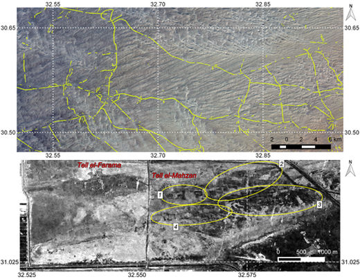
Techniques were implemented to extract anthropogenic features in the desert region of North Sinai using data from the first- and second-generation Phased Array type L-band Synthetic Aperture Radar (PALSAR-1 and 2). To obtain a synoptic view over the study area, a mosaic of average, multitemporal (De Grandi) filtered PALSAR-1 σ° backscatter of North Sinai was produced. Two subset regions were selected for further analysis. The first included an area of abundant linear features of high relative backscatter in a strategic, but sparsely developed area between the Wadi Tumilat and Gebel Maghara. The second included an area of low backscatter anomaly features in a coastal sabkha around the archaeological sites of Tell el-Farama, Tell el-Mahzan, and Tell el-Kanais. Over the subset region between the Wadi Tumilat and Gebel Maghara, algorithms were developed to extract linear features and convert them to vector format to facilitate interpretation. The algorithms were based on mathematical morphology, but to distinguish apparent man-made features from sand dune ridges, several techniques were applied. The first technique took as input the average σ° backscatter and used a Digital Elevation Model (DEM) derived Local Incidence Angle (LAI) mask to exclude sand dune ridges. The second technique, which proved more effective, used the average interferometric coherence as input. Extracted features were compared with other available information layers and in some cases revealed partially buried roads. Over the coastal subset region a time series of PALSAR-2 spotlight data were processed. The coefficient of variation (CoV) of De Grandi filtered imagery clearly revealed anomaly features of low CoV. These were compared with the results of an archaeological field walking survey carried out previously. The features generally correspond with isolated areas identified in the field survey as having a higher density of archaeological finds, and interpreted as possible islands of dry land, which may have been surrounded by lagoons, rivers, and swamplands in antiquity. It is suggested that these surrounding areas may still have a higher water content, sufficient to be detected in processed Synthetic Aperture Radar (SAR) imagery.
Keywords: Synthetic Aperture Radar (SAR); Phased Array type L-band Synthetic Aperture Radar (PALSAR); remote sensing; archaeology; desert; prospection; Sinai Synthetic Aperture Radar (SAR); Phased Array type L-band Synthetic Aperture Radar (PALSAR); remote sensing; archaeology; desert; prospection; Sinai
Graphical Abstract