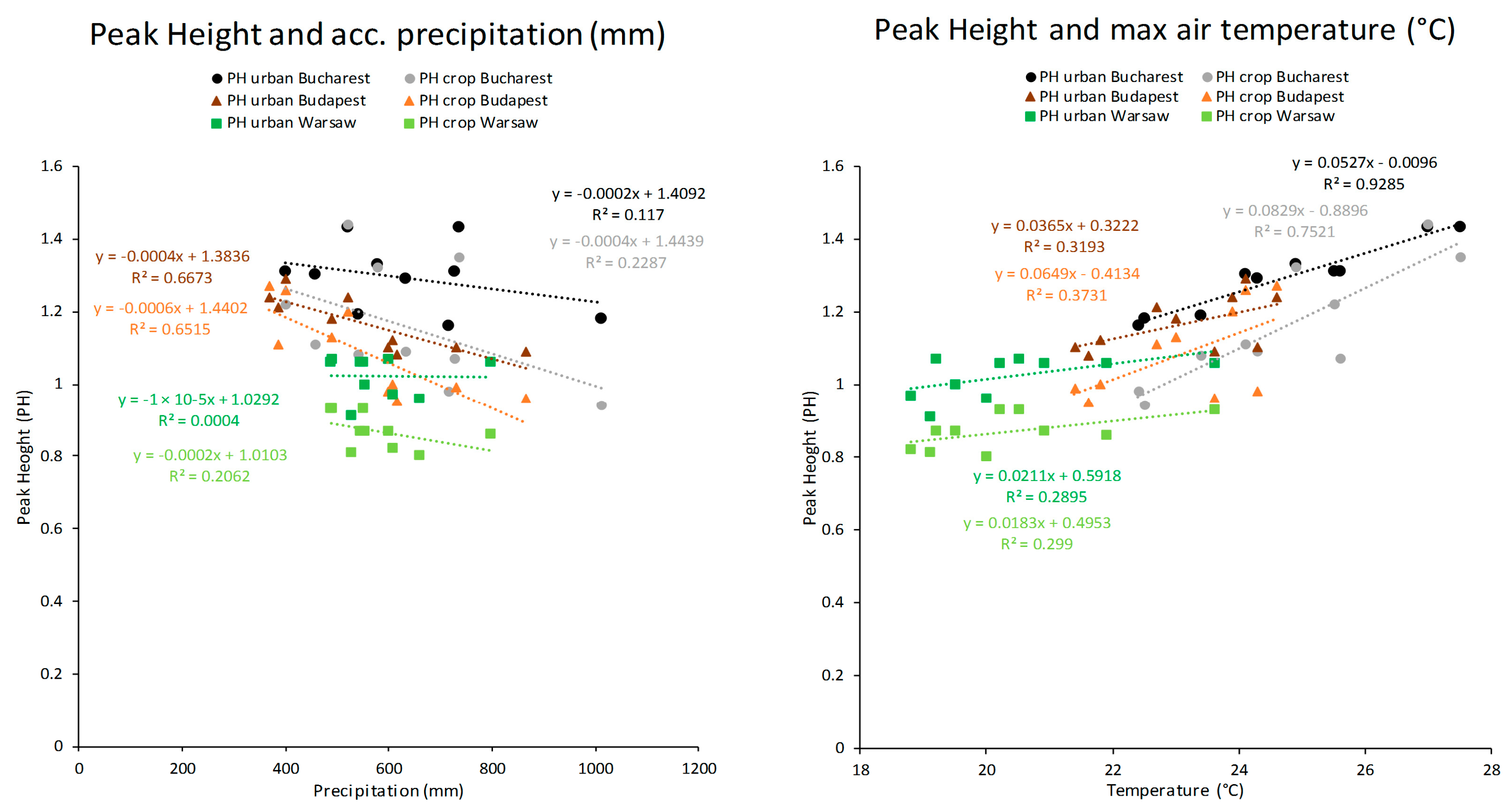
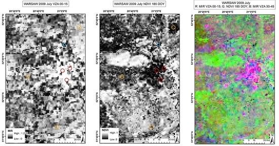
Urban–Rural Contrasts in Central-Eastern European Cities Using a MODIS 4 Micron Time Series
Abstract
:1. Introduction
2. Materials and Methods
2.1. Study Area
2.2. Data Sets
2.3. Methods
3. Results
3.1. Multiannual Analyses
3.1.1. Multiannual Average Comparison and Water Normalization
3.1.2. NDVI Comparison
3.1.3. View Zenith Angle Effects
3.1.4. Accumulated Radiance and the Convex Quadratic (CxQ) Model
3.2. Time Series Analyses over Years 2003–2012 from April to October
3.2.1. Bucharest
3.2.2. Budapest
3.2.3. Warsaw
4. Discussion
5. Conclusions
Acknowledgments
Author Contributions
Conflicts of Interest
Abbreviations
| AMMIR | Accumulated Monthly Middle Infrared Radiance |
| CxQ | Convex Quadratic model |
| MIR | Middle Infrared |
| MODIS | Moderate Resolution Imaging Spectroradiometer |
| NDVI | Normalized Difference Vegetation Index |
| PH | Peak Height |
| SLSTR | Sea and Land Surface Temperature Radiometer |
| TTP | Time to Peak |
| UTM | Universal Transverse Mercator |
| VZA | View Zenith Angle |
References
- Seto, K.C.; Fragkias, M.; Güneralp, B.; Reilly, M.K. A meta-analysis of global urban land expansion. PLoS ONE 2011, 6, 8. [Google Scholar] [CrossRef]
- Grimm, N.B.; Faeth, S.H.; Golubiewski, N.E.; Redman, C.L.; Wu, J.; Bai, X.; Briggs, J.M. Global change and the ecology of cities. Science 2008, 319, 756–760. [Google Scholar] [CrossRef]
- Martin, P.; Baudouin, Y.; Gachon, P. An alternative method to characterize the surface urban heat island. Int. J. Biometeorol. 2015, 59, 849–861. [Google Scholar] [CrossRef]
- Oke, T.R. The energetic basis of the urban heat island. Q. J. R. Meteorol. Soc. 1982, 108, 1–24. [Google Scholar] [CrossRef]
- Krehbiel, C.P.; Jackson, T.; Henebry, G.M. Web-Enabled Landsat Data time series for monitoring urban heat island impacts on land surface phenology. IEEE J. Sel. Top. Appl. Earth Observ. Remote Sens. 2016, 9, 2043–2050. [Google Scholar] [CrossRef]
- Krehbiel, C.P.; Henebry, G.M. A comparison of multiple datasets for monitoring thermal time in urban areas over the U.S. Upper Midwest. Remote Sens. 2016, 8, 297. [Google Scholar] [CrossRef]
- Lemonsu, A.; Viguié, V.; Daniel, M.; Masson, V. Vulnerability to heat waves: Impact of urban expansion scenarios on urban heat island and heat stress in Paris (France). Urban Clim. 2015, 14, 586–605. [Google Scholar] [CrossRef]
- Arnfield, A.J. Two decades of urban climate research: A review of turbulence, exchanges of energy and water, and the urban heat island. Int. J. Climatol. 2003, 23, 1–26. [Google Scholar] [CrossRef]
- Hooke, R.L.; Martín-Duque, J.F. Land transformation by humans: A review. GSA Today 2012, 22, 4–10. [Google Scholar] [CrossRef]
- Tran, H.; Uchihama, D.; Ochi, S.; Yasuoka, Y. Assessment with satellite data of the urban heat island effects in Asia mega cities. Int. J. Appl. Earth Observ. Geoinform. 2006, 8, 34–48. [Google Scholar] [CrossRef]
- Imhoff, M.L.; Zhang, P.; Wolfe, R.E.; Bounoua, L. Remote sensing of the urban heat island effect across biomes in the continental USA. Remote Sens. Environ. 2010, 144, 504–513. [Google Scholar] [CrossRef]
- Streutker, D.R. Satellite-measured growth of urban heat island of Houston, Texas. Remote Sens. Environ. 2003, 85, 282–289. [Google Scholar] [CrossRef]
- Weng, Q. Thermal infrared remote sensing for urban climate and environmental studies: Methods, applications, and trends. ISPRS J. Photogramm. Remote Sens. 2009, 64, 335–344. [Google Scholar] [CrossRef]
- Voogt, J.A.; Oke, T.R. Thermal remote sensing of urban climates. Remote Sens. Environ. 2003, 86, 370–384. [Google Scholar] [CrossRef]
- Tomlinson, C.J.; Chapman, L.; Thorne, J.E.; Baker, C. Remote sensing land surface temperature for meteorology and climatology: A review. Meteorol. Appl. 2011, 18, 296–306. [Google Scholar] [CrossRef]
- Potere, D.; Schneider, A. A critical look at representations of urban areas in global maps. GeoJournal 2007, 69, 55–80. [Google Scholar] [CrossRef]
- Gallo, K.P.; McNab, A.L.; Karl, T.R.; Brown, J.F.; Hood, J.J.; Tarpley, J.D. The use of NOAA AVHRR data for assessment of the urban heat island effect. J. Appl. Meteorol. 1993, 32, 899–908. [Google Scholar] [CrossRef]
- Stewart, I.D.; Oke, T.R. Local climate zones for urban temperature studies. Bull. Am. Meteorol. Soc. 2012, 93, 1879–1900. [Google Scholar] [CrossRef]
- Ju, J.; Roy, D.P. The availability of cloud-free Landsat ETM+ data over the conterminous United States and globally. Remote Sens. Environ. 2008, 112, 1196–1211. [Google Scholar] [CrossRef]
- Henebry, G.M. Mapping Human Settlements Using the mid-IR: Advantages, Prospects, and Limitations, in Urban Remote Sensing; Weng, Q., Quattrochi, D., Eds.; CRC Press: Boca Raton, FL, USA, 2007; pp. 339–355. [Google Scholar]
- Krehbiel, C.P.; Kovalskyy, V.; Henebry, G.M. Exploring the middle infrared region for urban remote sensing: Seasonal and view angle effects. Remote Sens. Lett. 2013, 4, 1147–1155. [Google Scholar] [CrossRef]
- Boyd, D.S.; Petitcolin, F. Remote sensing of the terrestrial environment using middle infrared radiation (3.0–5.0 μm). Int. J. Remote Sens. 2004, 25, 3343–3368. [Google Scholar] [CrossRef]
- Tomaszewska, M.; Kovalskyy, V.; Small, C.; Henebry, G.M. Viewing global megacities through MODIS radiance: Effects of time of year, latitude, land cover, and view zenith angle. IEEE J. Sel. Top. Appl. Earth Observ. Remote Sens. 2016, 9, 3753–3760. [Google Scholar] [CrossRef]
- Ianoş, I.; Sîrodoev, I.; Pascariu, G.; Henebry, G.M. Divergent patterns of built-up urban space growth following post-socialist changes. Urban Stud. 2015. [Google Scholar] [CrossRef]
- Hirt, S. Whatever happened to the (post) socialist city? Cities 2013, 32 (Suppl. 1), S29–S38. [Google Scholar] [CrossRef]
- Henebry, G.M.; de Beurs, K.M. Remote sensing of land surface phenology: A prospectus. In Phenology: An Integrative Environmental Science; Schwartz, M.D., Ed.; Springer: New York, NY, USA, 2013; pp. 385–411. [Google Scholar]
- De Beurs, K.M.; Henebry, G.M. Land surface phenology and temperature variation in the IGBP high-latitude transects. Glob. Chang. Biol. 2005, 11, 779–790. [Google Scholar] [CrossRef]
- Coumou, D.; Robinson, A.; Rahmstorf, S. Global increase in record-breaking monthly-mean temperatures. Clim. Chang. 2013, 118, 771–782. [Google Scholar] [CrossRef]
- Meehl, G.A.; Tebaldi, C. More intense, more frequent and longer lasting heat waves in the 21st century. Science 2004, 305, 994–997. [Google Scholar] [CrossRef]
- Kottek, M.; Grieser, J.; Beck, C.; Rudolf, B.; Rubel, F. World Map of the Köppen-Geiger climate classification updated. Meteorol. Z. 2006, 15, 259–263. [Google Scholar] [CrossRef]
- Cracknell, A.; Boyd, D.S. Interactions of Middle Infrared (3–5 µm) Radiation with the Environment. In The Sage Handbook of Remote Sensing; Warner, T.A., Nellis, M.D., Foody, G.M., Eds.; Sage: Thousand Oaks, CA, USA, 2009. [Google Scholar]
- Boyd, D.S.; Wicks, T.E.; Curran, P.J. Use of middle infrared radiation to estimate the leaf area index of a boreal forest. Tree Physiol. 2000, 20, 755–760. [Google Scholar] [CrossRef]
- Tucker, C.J. Red and photographic infrared linear combinations for monitoring vegetation. Remote Sens. Environ. 1979, 8, 127–150. [Google Scholar] [CrossRef]
- Fuller, R.A.; Gaston, K.J. The scaling of green space coverage in European cities. Biol. Lett. 2009, 5, 352–355. [Google Scholar] [CrossRef]
- Petrişor, A. Assessment of the green infrastructure of Bucharest using Corine and Urban Atlas data. Urban. Archit. Constr. 2015, 6, 19–24. [Google Scholar]
- García-Herrera, R.; Diaz, J.; Trigo, R.M.; Luterbacher, J.; Fischer, E.M. A review of the European summer heat wave of 2003. Crit. Rev. Environ. Sci. Technol. 2010, 40, 267–306. [Google Scholar] [CrossRef]
- Wright, C.K.; de Beurs, K.M.; Henebry, G.M. Land surface anomalies preceding the 2010 Russian heat wave and a link to the North Atlantic Oscillation. Environ. Res. Lett. 2014, 9, 124015. [Google Scholar] [CrossRef]


| City | Population (Millions) | Area (km2) | |
|---|---|---|---|
| 2003 | 2012 | ||
| Bucharest | 1.90 | 1.88 | 238 |
| Budapest | 1.71 | 1.72 | 525 |
| Warsaw | 1.68 | 1.71 | 517 |
| Urban | Crop | Urban-Crop | ||||
|---|---|---|---|---|---|---|
| TTP | PH | TTP | PH | TTP | PH | |
| Bucharest | 5.07 | 1.29 | 4.76 | 1.16 | 0.31 | 0.13 |
| Budapest | 4.53 | 1.17 | 4.37 | 1.08 | 0.16 | 0.09 |
| Warsaw | 3.73 | 1.02 | 3.41 | 0.87 | 0.32 | 0.15 |
| Max MIR | 2003 | 2004 | 2005 | 2006 | 2007 | 2008 | 2009 | 2010 | 2011 | 2012 | MEAN | |
|---|---|---|---|---|---|---|---|---|---|---|---|---|
| Bucharest | Urban | 1.32 | 1.22 | 1.22 | 1.18 | 1.53 | 1.32 | 1.30 | 1.34 | 1.37 | 1.44 | 1.33 |
| Crop | 1.29 | 1.03 | 0.93 | 1.08 | 1.64 | 1.31 | 1.10 | 1.19 | 1.15 | 1.43 | 1.21 | |
| Budapest | 1.22 | 1.19 | 1.11 | 1.20 | 1.39 | 1.10 | 1.18 | 1.17 | 1.30 | 1.32 | 1.22 | |
| 1.23 | 1.01 | 1.05 | 0.99 | 1.43 | 1.02 | 1.10 | 1.00 | 1.17 | 1.23 | 1.12 | ||
| Warsaw | 1.03 | 0.92 | 1.09 | 1.20 | 1.09 | 1.02 | 0.94 | 1.21 | 0.98 | 1.07 | 1.05 | |
| 0.92 | 0.85 | 0.91 | 1.05 | 0.87 | 0.87 | 0.79 | 0.98 | 0.81 | 0.84 | 0.89 |
| Weather | 2003 | 2004 | 2005 | 2006 | 2007 | 2008 | 2009 | 2010 | 2011 | 2012 | MEAN | |
|---|---|---|---|---|---|---|---|---|---|---|---|---|
| Bucharest | (mm) | 578.6 | 716.8 | 1013.4 | 541.2 | 520.9 | 400.3 | 632.6 | 728.0 | 459.2 | 736.9 | 632.79 |
| (°C) | 24.9 | 22.4 | 22.5 | 23.4 | 27.0 | 25.5 | 24.3 | 25.6 | 24.1 | 27.5 | 24.72 | |
| Budapest | 369.0 | 616.2 | 732 | 597.9 | 522.8 | 608.6 | 488.7 | 867.1 | 387.6 | 400.6 | 559.05 | |
| 24.6 | 21.6 | 21.4 | 24.3 | 23.9 | 21.8 | 23.0 | 23.6 | 22.7 | 24.1 | 23.10 | ||
| Warsaw | 550.9 | 527.0 | 490.5 | 488.1 | 599.9 | 552.9 | 659.2 | 796.5 | 608.7 | 544.1 | 581.78 | |
| 20.2 | 19.1 | 20.5 | 23.6 | 19.2 | 19.5 | 20.0 | 21.9 | 18.8 | 20.9 | 20.37 |
© 2016 by the authors; licensee MDPI, Basel, Switzerland. This article is an open access article distributed under the terms and conditions of the Creative Commons Attribution (CC-BY) license (http://creativecommons.org/licenses/by/4.0/).
Share and Cite
Tomaszewska, M.; Henebry, G.M. Urban–Rural Contrasts in Central-Eastern European Cities Using a MODIS 4 Micron Time Series. Remote Sens. 2016, 8, 924. https://doi.org/10.3390/rs8110924
Tomaszewska M, Henebry GM. Urban–Rural Contrasts in Central-Eastern European Cities Using a MODIS 4 Micron Time Series. Remote Sensing. 2016; 8(11):924. https://doi.org/10.3390/rs8110924
Chicago/Turabian StyleTomaszewska, Monika, and Geoffrey M. Henebry. 2016. "Urban–Rural Contrasts in Central-Eastern European Cities Using a MODIS 4 Micron Time Series" Remote Sensing 8, no. 11: 924. https://doi.org/10.3390/rs8110924
APA StyleTomaszewska, M., & Henebry, G. M. (2016). Urban–Rural Contrasts in Central-Eastern European Cities Using a MODIS 4 Micron Time Series. Remote Sensing, 8(11), 924. https://doi.org/10.3390/rs8110924


