
Water Constituents and Water Depth Retrieval from Sentinel-2A—A First Evaluation in an Oligotrophic Lake


Abstract
:
1. Introduction
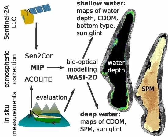
2. Materials and Methods
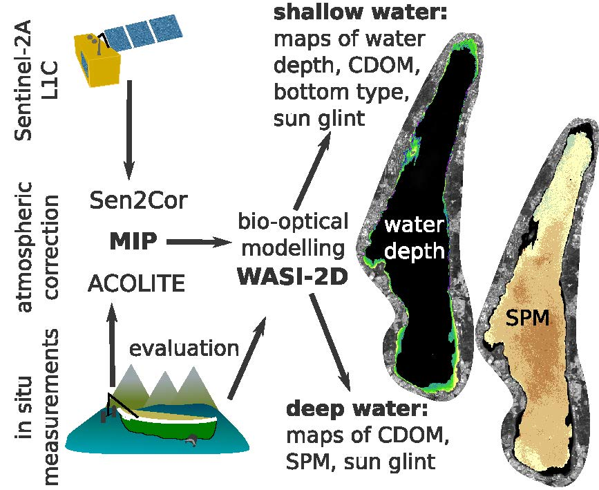
2.1. Study Area and Field Data
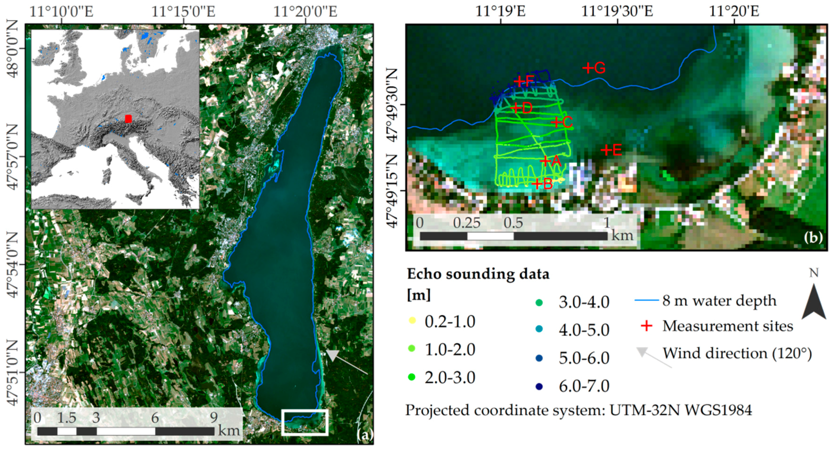
2.2. Preprocessing of S2-A Data
2.3. Inverse Modelling with WASI-2D
2.4. Retrieval of Inherent Optical Properties from In Situ Measurements
3. Results and Discussion
3.1. Comparison of Atmospheric Correction Approaches
3.2. Optically Deep Water
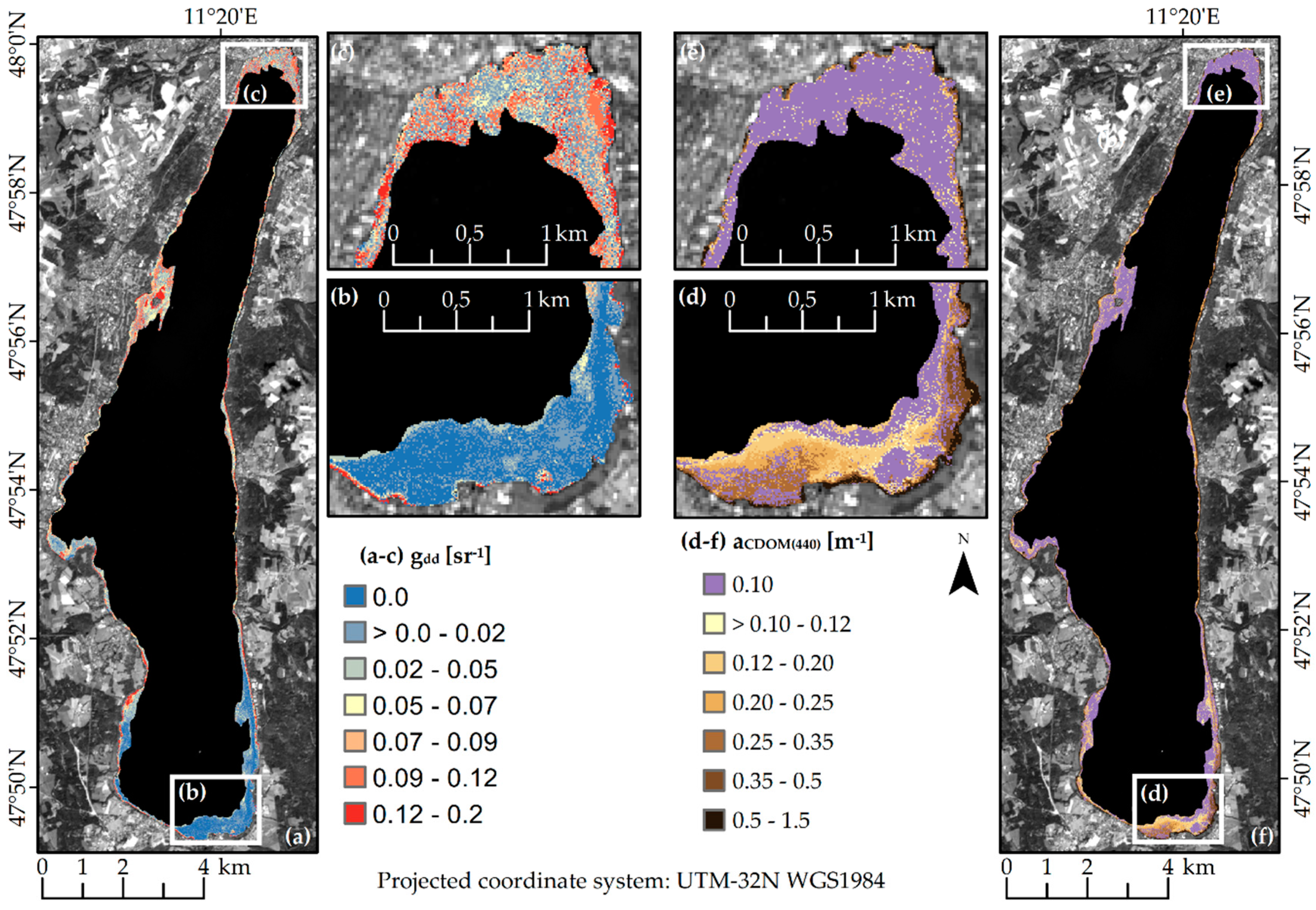
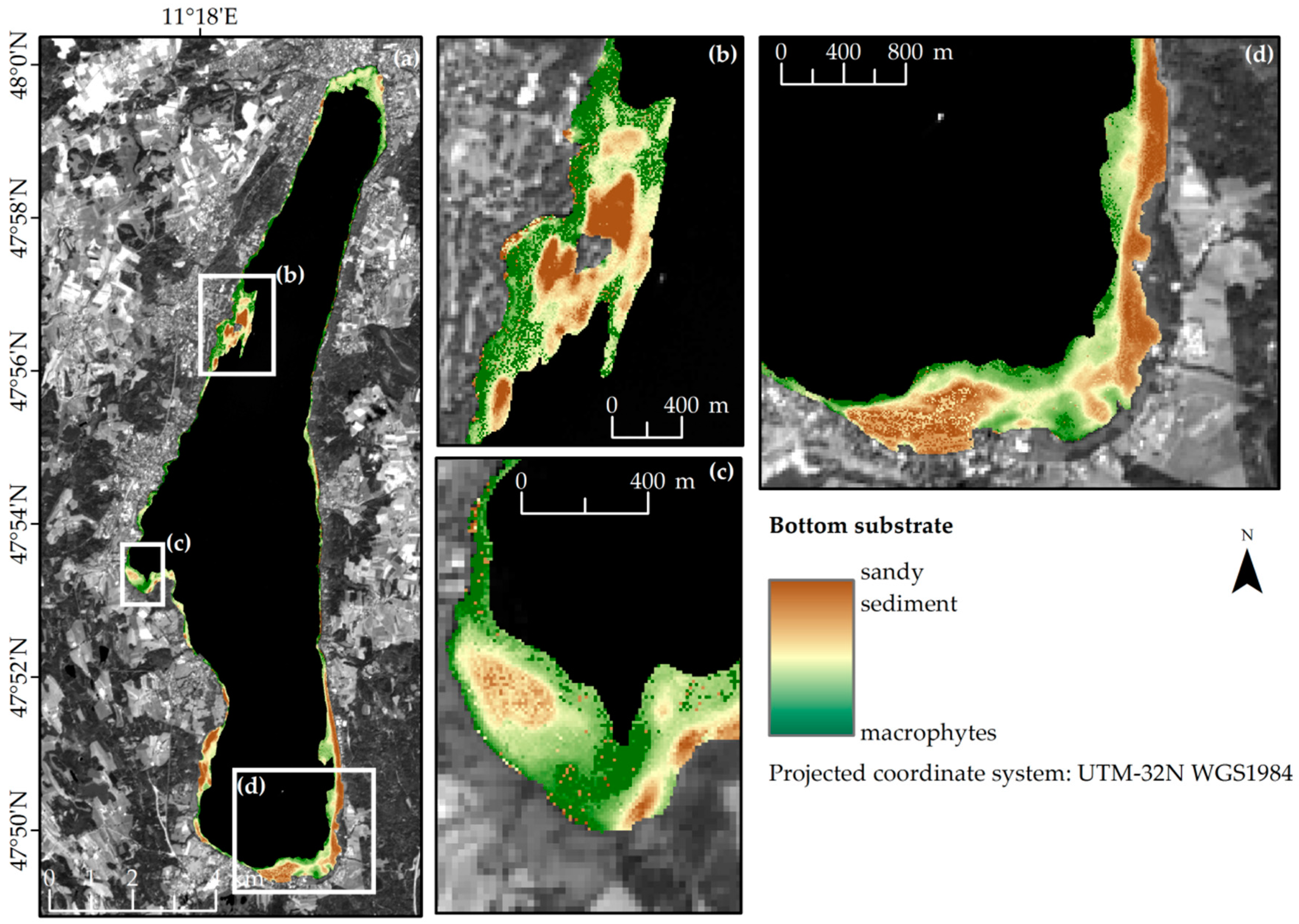
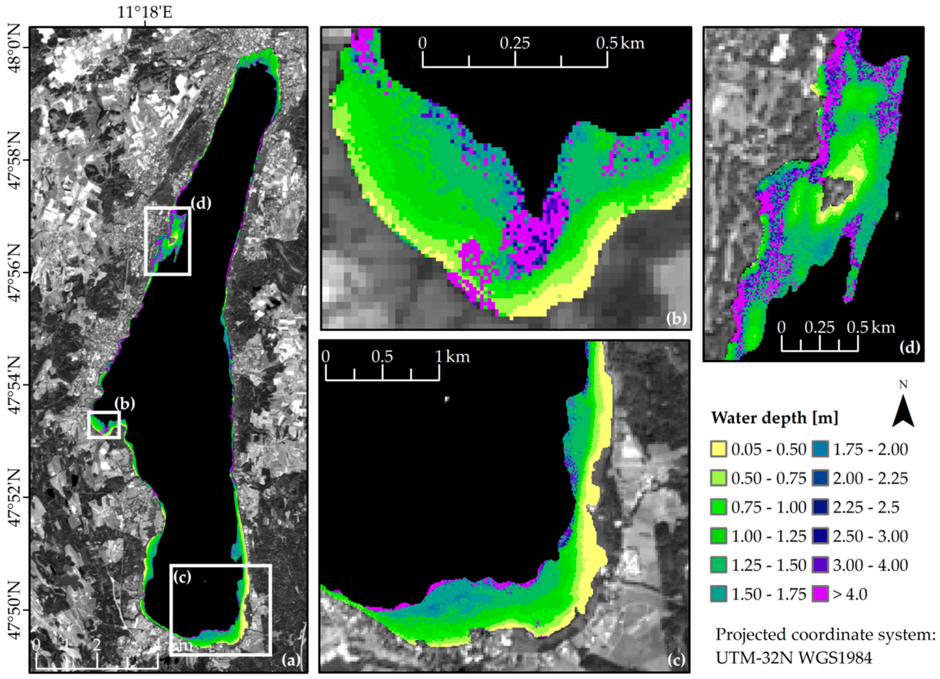
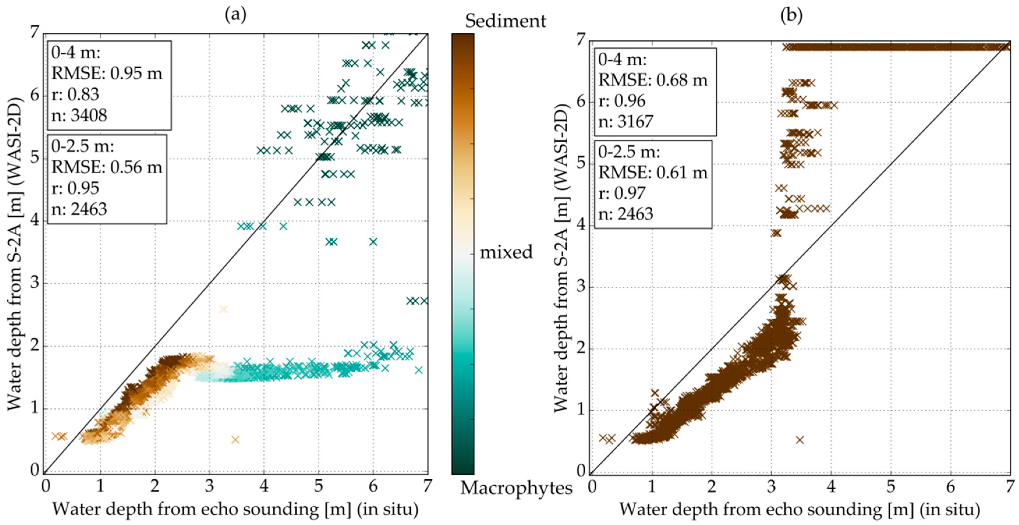
3.3. Optically Shallow Water
4. Conclusions
Acknowledgments
Author Contributions
Conflicts of Interest
Abbreviations
| aCDOM(440) | absorption of coloured dissolved organic matter at reference wavelength 440 nm |
| AOT | aerosol optical thickness |
| b*b,SPM(550) | mass-specific backscattering coefficient of SPM at reference wavelength 550 nm |
| bb,SPM(λ) | backscattering coefficient of SPM at reference wavelength 550 nm |
| CDOM | coloured dissolved organic matter |
| Chl-a | chlorophyll-a |
| Ed(z,λ) | downwelling spectral irradiance |
| gdd | fraction of sun glint per pixel area |
| Lu(z,λ) | upwelling spectral radiance |
| MAPE | Mean absolute percentage error |
| MIP | Modular Inverse Processing System |
| NEΔRrsE | Noise-equivalent remote sensing reflectance difference |
| S2-A | Sentinel-2A |
| r | Pearson’s correlation coefficient |
| RMSE | Root Mean Square Error |
| (0+, λ) | radiance reflectance above water |
| (0+, λ) | radiance reflectance above water derived from FREEDOM measurements |
| (0+, λ) | radiance reflectance above water derived from RAMSES measurements |
| SPM | suspended particulate matter |
| SWIR | shortwave infrared |
| VNIR | visible near-infrared |
| X² | Chi-Square |
| z | sensor depth |
References
- Adrian, R.; O’Reilly, C.M.; Zagarese, H.; Baines, S.B.; Hessen, D.O.; Keller, W.; Livingstone, D.M.; Sommaruga, R.; Straile, D.; van Donk, E.; et al. Lakes as sentinels of climate change. Limnol. Oceanogr. 2009, 54, 2283–2297. [Google Scholar] [CrossRef] [PubMed] [Green Version]
- Stendera, S.; Adrian, R.; Bonada, N.; Cañedo-Argüelles, M.; Hugueny, B.; Januschke, K.; Pletterbauer, F.; Hering, D. Drivers and stressors of freshwater biodiversity patterns across different ecosystems and scales: A review. Hydrobiologia 2012, 696, 1–28. [Google Scholar] [CrossRef]
- Millennium Ecosystem Assessment. Ecosystems and Human Well-Being: Wetlands and Water Synthesis; World Resources Institute: Washington, DC, USA, 2005; pp. 1–68. [Google Scholar]
- European Commission. The Water Framework Directive (Directive 2000/60/EC of the European Parliament and of the Council of 23 October 2000 Establishing A Framework for Community Action in the Field of Water Policy); Official Journal of the European Communities: Brussels, Belgium, 2000; pp. 1–72. [Google Scholar]
- United States Congress House. Federal Water Pollution Control Act, 33 U.S.C. §1251–1387; Environmental Protection Agency: Washington, DC, USA, 2002; pp. 1–234.
- Hering, D.; Borja, A.; Carstensen, J.; Carvalho, L.; Elliott, M.; Feld, C.K.; Heiskanen, A.S.; Johnson, R.K.; Moe, J.; Pont, D.; et al. The European Water Framework Directive at the age of 10: A critical review of the achievements with recommendations for the future. Sci. Total Environ. 2010, 408, 4007–4019. [Google Scholar] [CrossRef] [PubMed] [Green Version]
- Birk, S.; Bonne, W.; Borja, A.; Brucet, S.; Courrat, A.; Poikane, S.; Solimini, A.; van de Bund, W.; Zampoukas, N.; Hering, D. Three hundred ways to assess Europe’s surface waters: An almost complete overview of biological methods to implement the Water Framework Directive. Ecol. Indic. 2012, 18, 31–41. [Google Scholar] [CrossRef]
- Schaeffer, B.A.; Schaeffer, K.G.; Keith, D.J.; Lunetta, R.S.; Conmy, R.; Gould, R.W. Barriers to adopting satellite remote sensing for water quality management. Int. J. Remote Sens. 2013, 34, 7534–7544. [Google Scholar] [CrossRef]
- Reyjol, Y.; Argillier, C.; Bonne, W.; Borja, A.; Buijse, A.D.; Cardoso, A.C.; Daufresne, M.; Kernan, M.; Ferreira, M.T.; Poikane, S.; et al. Assessing the ecological status in the context of the European Water Framework Directive: Where do we go now? Sci. Total Environ. 2014, 497–498, 332–344. [Google Scholar] [CrossRef] [PubMed]
- Dörnhöfer, K.; Oppelt, N. Remote sensing for lake research and monitoring—Recent advances. Ecol. Indic. 2016, 64, 105–122. [Google Scholar] [CrossRef]
- Dekker, A.G.; Phinn, S.R.; Anstee, J.M.; Bissett, W.P.; Brando, V.E.; Casey, B.; Fearns, P.R.; Hedley, J.D.; Klonowski, W.; Lee, Z.P.; et al. Intercomparison of shallow water bathymetry, hydro-optics, and benthos mapping techniques in Australian and Caribbean coastal environments. Limnol. Oceanogr. Methods 2011, 9, 396–425. [Google Scholar] [CrossRef]
- Gao, J. Bathymetric mapping by means of remote sensing: Methods, accuracy and limitations. Prog. Phys. Geogr. 2009, 33, 103–116. [Google Scholar] [CrossRef]
- Matthews, M.W. A current review of empirical procedures of remote sensing in inland and near-coastal transitional waters. Int. J. Remote Sens. 2011, 32, 6855–6899. [Google Scholar] [CrossRef]
- Odermatt, D.; Gitelson, A.; Brando, V.E.; Schaepman, M. Review of constituent retrieval in optically deep and complex waters from satellite imagery. Remote Sens. Environ. 2012, 118, 116–126. [Google Scholar] [CrossRef] [Green Version]
- Palmer, S.; Odermatt, D.; Hunter, P.D.; Brockmann, C.; Présing, M.; Balzter, H.; Tóth, V.R. Satellite remote sensing of phytoplankton phenology in Lake Balaton using 10 years of MERIS observations. Remote Sens. Environ. 2015, 158, 441–452. [Google Scholar] [CrossRef] [Green Version]
- Kiefer, I.; Odermatt, D.; Anneville, O.; Wüest, A.; Bouffard, D. Application of remote sensing for the optimization of in-situ sampling for monitoring of phytoplankton abundance in a large lake. Sci. Total Environ. 2015, 527–528, 493–506. [Google Scholar] [CrossRef] [PubMed]
- Jiang, G.; Ma, R.; Loiselle, S.A.; Duan, H.; Su, W.; Cai, W.; Huang, C.; Yang, J.; Yu, W. Remote sensing of particulate organic carbon dynamics in a eutrophic lake (Taihu Lake, China). Sci. Total Environ. 2015, 532, 245–254. [Google Scholar] [CrossRef] [PubMed]
- Luo, J.; Li, X.; Ma, R.; Li, F.; Duan, H.; Hu, W.; Qin, B.; Huang, W. Applying remote sensing techniques to monitoring seasonal and interannual changes of aquatic vegetation in Taihu Lake, China. Ecol. Indic. 2016, 60, 503–513. [Google Scholar] [CrossRef]
- Shi, K.; Zhang, Y.; Zhu, G.; Liu, X.; Zhou, Y.; Xu, H.; Qin, B.; Liu, G.; Li, Y. Long-term remote monitoring of total suspended matter concentration in Lake Taihu using 250 m MODIS-Aqua data. Remote Sens. Environ. 2015, 164, 43–56. [Google Scholar] [CrossRef]
- Binding, C.E.; Greenberg, T.A.; Watson, S.B.; Rastin, S.; Gould, J. Long term water clarity changes in North America’s Great Lakes from multi-sensor satellite observations. Limnol. Oceanogr. 2015, 60, 1976–1995. [Google Scholar] [CrossRef]
- Matthews, M.W. Eutrophication and cyanobacterial blooms in South African inland waters: 10 years of MERIS observations. Remote Sens. Environ. 2014, 155, 161–177. [Google Scholar] [CrossRef]
- Matthews, M.W.; Bernard, S.; Winter, K. Remote sensing of cyanobacteria-dominant algal blooms and water quality parameters in Zeekoevlei, a small hypertrophic lake, using MERIS. Remote Sens. Environ. 2010, 114, 2070–2087. [Google Scholar] [CrossRef]
- Chao Rodríguez, Y.; el Anjoumi, A.; Domínguez-Gómez, J.A.; Rodríguez Pérez, D.; Rico, E. Using Landsat image time series to study a small water body in Northern Spain. Environ. Monit. Assess. 2014, 186, 3511–3522. [Google Scholar] [CrossRef] [PubMed]
- Yuzugullu, O.; Aksoy, A. Generation of the bathymetry of a eutrophic shallow lake using WorldView-2 imagery. J. Hydroinform. 2014, 16, 50–59. [Google Scholar] [CrossRef]
- Heblinski, J.; Schmieder, K.; Heege, T.; Agyemang, T.K.; Sayadyan, H.; Vardanyan, L. High-resolution satellite remote sensing of littoral vegetation of Lake Sevan (Armenia) as a basis for monitoring and assessment. Hydrobiologia 2011, 661, 97–111. [Google Scholar] [CrossRef]
- Bolpagni, R.; Bresciani, M.; Laini, A.; Pinardi, M.; Matta, E.; Ampe, E.M.; Giardino, C.; Viaroli, P.; Bartoli, M. Remote sensing of phytoplankton-macrophyte coexistence in shallow hypereutrophic fluvial lakes. Hydrobiologia 2014, 737, 67–76. [Google Scholar] [CrossRef]
- Giardino, C.; Bresciani, M.; Valentini, E.; Gasperini, L.; Bolpagni, R.; Brando, V.E. Airborne hyperspectral data to assess suspended particulate matter and aquatic vegetation in a shallow and turbid lake. Remote Sens. Environ. 2015, 157, 48–57. [Google Scholar] [CrossRef]
- Hunter, P.D.; Gilvear, D.J.; Tyler, A.N.; Willby, N.J.; Kelly, A. Mapping macrophytic vegetation in shallow lakes using the Compact Airborne Spectrographic Imager (CASI). Aquat. Conserv. Mar. Freshw. Ecosyst. 2010, 20, 717–727. [Google Scholar] [CrossRef]
- Palmer, S.C.; Kutser, T.; Hunter, P.D. Remote sensing of inland waters: Challenges, progress and future directions. Remote Sens. Environ. 2015, 157, 1–8. [Google Scholar] [CrossRef]
- Eder, E.; Dörnhöfer, K.; Gege, P.; Schenk, K.; Klinger, P.; Wenzel, J.; Oppelt, N.; Gruber, N. Analysis of mineral-rich suspended matter in glacial lakes using simulations and satellite data. In Living Planet Symposium; Ouwehand, L., Ed.; ESA Communications: Noordwijk, The Netherlands, 2016; Volume 740. [Google Scholar]
- Giardino, C.; Bresciani, M.; Cazzaniga, I.; Schenk, K.; Rieger, P.; Braga, F.; Matta, E.; Brando, V.E. Evaluation of multi-resolution satellite sensors for assessing water quality and bottom depth of Lake Garda. Sensors 2014, 14, 24116–24131. [Google Scholar] [CrossRef] [PubMed]
- Lobo, F.L.; Costa, M.P.; Novo, E.M. Time-series analysis of Landsat-MSS/TM/OLI images over Amazonian waters impacted by gold mining activities. Remote Sens. Environ. 2015, 157, 170–184. [Google Scholar] [CrossRef]
- Slonecker, E.T.; Jones, D.K.; Pellerin, B.A. The new Landsat 8 potential for remote sensing of colored dissolved organic matter (CDOM). Mar. Pollut. Bull. 2016, 107, 518–527. [Google Scholar] [CrossRef] [PubMed]
- Giardino, C.; Bresciani, M.; Fava, F.; Matta, E.; Brando, V.E.; Colombo, R. Mapping submerged habitats and mangroves of Lampi Island Marine National Park (Myanmar) from in situ and satellite observations. Remote Sens. 2016, 8, 2. [Google Scholar] [CrossRef]
- Lee, Z.P.; Shang, S.; Qi, L.; Yan, J.; Lin, G. A semi-analytical scheme to estimate Secchi-disk depth from Landsat-8 measurements. Remote Sens. Environ. 2016, 177, 101–106. [Google Scholar] [CrossRef]
- Manzo, C.; Bresciani, M.; Giardino, C.; Braga, F.; Bassani, C. Sensitivity analysis of a bio-optical model for Italian lakes focused on Landsat-8, Sentinel-2 and Sentinel-3. Eur. J. Remote Sens. 2015, 48, 17–32. [Google Scholar] [CrossRef]
- Kutser, T.; Paavel, B.; Verpoorter, C.; Ligi, M.; Soomets, T.; Toming, K.; Casal, G. Remote sensing of Black Lakes and using 810 nm reflectance peak for retrieving water quality parameters of optically complex waters. Remote Sens. 2016, 8, 497. [Google Scholar] [CrossRef]
- Hedley, J.D.; Roelfsema, C.; Koetz, B.; Phinn, S. Capability of the Sentinel 2 mission for tropical coral reef mapping and coral bleaching detection. Remote Sens. Environ. 2012, 120, 145–155. [Google Scholar] [CrossRef]
- Toming, K.; Kutser, T.; Laas, A.; Sepp, M.; Paavel, B.; Nõges, T. First experiences in mapping lake water quality parameters with Sentinel-2 MSI imagery. Remote Sens. 2016, 8, 640. [Google Scholar] [CrossRef]
- Arle, J.; Blondzik, K.; Claussen, U.; Duffek, A.; Grimm, S.; Hilliges, F.; Hoffmann, A.; Leujak, W.; Mohaupt, V.; Naumann, S.; et al. Wasserwirtschaft in Deutschland. Teil 2. Gewässergüte; Umweltbundesamt (UBA): Bonn, Germany, 2013. [Google Scholar]
- Roessler, S.; Wolf, P.; Schneider, T.; Melzer, A. Multispectral remote sensing of invasive aquatic plants using RapidEye. In Earth Observation of Global Changes (EOGC); Krisp, J.M., Meng, L., Pail, R., Stilla, U., Eds.; Springer: Berlin/Heidelberg, Germany, 2013; pp. 109–123. [Google Scholar]
- Rößler, S.; Wolf, P.; Schneider, T.; Melzer, A. Monitoring of invasive aquatic plants using multitemporal RapidEye-data. In Proceedings of the 1st EARSeL Workshop on Temporal Analysis of Satellite Images, Mykonos, Greece, 23–25 May 2012; EARSeL: Mykonos Island, Greece, 2012. [Google Scholar]
- Rößler, S.; Wolf, P.; Schneider, T.; Zimmermann, S.; Melzer, A. Water constituent retrieval and littoral bottom mapping using hyperspectral APEX imagery and submersed artificial surfaces. EARSeL eProc. 2013, 12, 44–57. [Google Scholar]
- Giardino, C.; Candiani, G.; Bresciani, M.; Lee, Z.P.; Gagliano, S.; Pepe, M. BOMBER: A tool for estimating water quality and bottom properties from remote sensing images. Comput. Geosci. 2012, 45, 313–318. [Google Scholar] [CrossRef]
- Gege, P. A case study at Starnberger See for hyperspectral bathymetry mapping using inverse modelling. In Proceedings of the WHISPERS conference, Lausanne, Switzerland, 25–27 June 2014; pp. 1–4.
- Gege, P. WASI-2D: A software tool for regionally optimized analysis of imaging spectrometer data from deep and shallow waters. Comput. Geosci. 2014, 62, 208–215. [Google Scholar] [CrossRef]
- Dörnhöfer, K.; Gege, P.; Pflug, B.; Oppelt, N. Mapping indicators of lake ecology at Lake Starnberg, Germany—First results of Sentinel-2A. In Living Planet Symposium; Ouwehand, L., Ed.; ESA Communications: Noordwijk, The Netherlands, 2016; Volume 740. [Google Scholar]
- Wöbbecke, K.; Klett, G.; Rechenberk, B. Wasserbeschaffenheit der Wichtigsten Seen in der Bundesrepublik Deutschland: Datensammlung 1981–2000; Umweltbundesamt (UBA): Berlin, Germany, 2003. [Google Scholar]
- Melzer, A.; Zimmermann, S.; Schorer, A. Seelitorale in Bayern: Starnberger See, Makrophyten-Kartierungen 1979, 1989 und 2000; Bayerisches Landesamt für Wasserwirtschaft: München, Germany, 2003. [Google Scholar]
- GKD Bayern. Data of Measure Point Lake Starnberg, 2013. Available online: http://www.gkd.bayern.de/seen/chemie/karten/index.php?thema=gkd&rubrik=seen&produkt=chemie&gknr=0 (accessed on 14 April 2016).
- Riedel, S.; Gege, P.; Schneider, M.; Pflug, B.; Oppelt, N. Comparison of atmospheric parameters derived from in-situ and hyperspectral remote sensing data beautiful Bavarian lakes. In Living Planet Symposium; Ouwehand, L., Ed.; ESA Communications: Noordwijk, The Netherlands, 2016; Volume 740. [Google Scholar]
- Labsphere. Spectralon, Diffuse Reflectance Targets. 10% nominal reflectance value. SRT 10-050 Nr. 50 039084 000. Available online: https://www.labsphere.com/site/assets/files/1828/spectralon_targets.pdf (accessed on 8 November 2016).
- TriOS. RAMSES Radiometer, 2015. Available online: http://www.trios.de/en/products/sensors/ramses.html (accessed on 5 July 2016).
- Deutscher Wetterdienst (DWD). Climatological time series of station Starnberg and Attenkam. WebWerdis, 2016. Available online: https://werdis.dwd.de/werdis/start_js_JSP.do (accessed on 5 July 2016).
- Strömbeck, N.; Pierson, D.C. The effects of variability in the inherent optical properties on estimations of chlorophyll a by remote sensing in Swedish freshwaters. Sci. Total Environ. 2001, 268, 123–137. [Google Scholar] [CrossRef]
- Bavarian Environmental Agency (BEA). Download Gauge Starnberg, Starnberger See. Available online: http://www.gkd.bayern.de/fluesse/abfluss/stationen/stammdaten/index.php?thema=gkd&rubrik=seen&produkt=wasserstand&gknr=0&msnr=16663002 (accessed on 5 July 2016).
- Bavarian Environmental Agency (BEA). Digital Elevation Model of Lake Starnberg; BEA: Augsburg, Germany, 2000. [Google Scholar]
- Müller-Wilm, U. S2PAD SEN2COR 2.2.0–Readme, S2PAD-VEGA-SRN-0001; Telespazio VEGA Deutschland GmbH: Darmstadt, Germany, 2016. [Google Scholar]
- Vanhellemont, Q.; Ruddick, K. ACOLITE for Sentinel-2: Aquatic applications of MSI imagery. In Living Planet Symposium; Ouwehand, L., Ed.; ESA Communications: Noordwijk, The Netherlands, 2016; Volume 740. [Google Scholar]
- Vanhellemont, Q.; Ruddick, K. Advantages of high quality SWIR bands for ocean colour processing: Examples from Landsat-8. Remote Sens. Environ. 2015, 161, 89–106. [Google Scholar] [CrossRef]
- Heege, T.; Kiselev, V.; Wettle, M.; Hung, N.N. Operational multi-sensor monitoring of turbidity for the entire Mekong Delta. Int. J. Remote Sens. 2014, 35, 2910–2926. [Google Scholar] [CrossRef]
- Heege, T.; Fischer, J. Mapping of water constituents in Lake Constance using multispectral airborne scanner data and a physically based processing scheme. Can. J. Remote Sens. 2004, 30, 77–86. [Google Scholar] [CrossRef]
- Heege, T. Flugzeuggestützte Fernerkundung von Wasserinhaltsstoffen am Bodensee. Ph.D. Thesis, Freien Universitat Berlin, Berlin, Germany, 2000. [Google Scholar]
- Mobley, C.D.; Boss, E.; Roesler, C. Ocean Optics Web Book, 2015. Available online: http://www.oceanopticsbook.info/ (accessed on 11 October 2016).
- Vanhellemont, Q.; Ruddick, K. Turbid wakes associated with offshore wind turbines observed with Landsat 8. Remote Sens. Environ. 2014, 145, 105–115. [Google Scholar] [CrossRef]
- European Space Agency (ESA). Sentinel-2A Spectral Response Functions (S2A-SRF), 2015. Available online: https://earth.esa.int/web/sentinel/user-guides/document-library/-/asset_publisher/xlslt4309D5h/content/sentinel-2a-spectral-responses;jsessionid=1D8024CC54B3F0A8C66B6C9D562987C4.eodisp-prod4040?redirect=https%3A%2F%2Fearth.esa.int%2Fweb%2Fsentinel%2Fuser-guides%2Fdocument-library%3Bjsessionid%3D1D8024CC54B3F0A8C66B6C9D562987C4.eodisp-prod4040%3Fp_p_id%3D101_INSTANCE_xlslt4309D5h%26p_p_lifecycle%3D0%26p_p_state%3Dnormal%26p_p_mode%3Dview%26p_p_col_id%3Dcolumn-1%26p_p_col_count%3D1 (accessed on 14 April 2016).
- Sterckx, S.; Knaeps, E.; Kratzer, S.; Ruddick, K. SIMilarity Environment Correction (SIMEC) applied to MERIS data over inland and coastal waters. Remote Sens. Environ. 2015, 157, 96–110. [Google Scholar] [CrossRef]
- Brando, V.E.; Dekker, A.G. Satellite hyperspectral remote sensing for estimating estuarine and coastal water quality. IEEE Trans. Geosci. Remote Sens. 2003, 41, 1378–1387. [Google Scholar] [CrossRef]
- Albert, A.; Mobley, C.D. An analytical model for subsurface irradiance and remote sensing reflectance in deep and shallow case-2 waters. Opt. Express 2003, 11, 2873–2890. [Google Scholar] [CrossRef] [PubMed]
- Gregg, W.W.; Carder, K.L. A simple spectral solar irradiance model for cloudless maritime atmospheres. Limnol. Oceanogr. 1990, 35, 1657–1675. [Google Scholar] [CrossRef]
- Gege, P. Estimation of phytoplankton concentration from downwelling irradiance measurements in water. Israel J. Plant Sci. 2012, 60, 193–207. [Google Scholar] [CrossRef] [Green Version]
- Linnemann, K.; Gege, P.; Rößler, S.; Schneider, T.; Melzer, A. CDOM retrieval using measurements of downwelling irradiance. In SPIE Remote Sensing of the Ocean, Sea Ice, Coastal Waters, and Large Water Regions 2013; Bostater, C.R., Mertikas, S.P., Neyt, X., Eds.; SPIE: Dresden, Germany, 2013. [Google Scholar]
- Sterckx, S.; Knaeps, E.; Ruddick, K. Detection and correction of adjacency effects in hyperspectral airborne data of coastal and inland waters: The use of the near infrared similarity spectrum. Int. J. Remote Sens. 2011, 32, 6479–6505. [Google Scholar] [CrossRef]
- Santer, R.; Schmechtig, C. Adjacency effects on water surfaces: Primary scattering approximation and sensitivity study. Appl. Opt. 2000, 39, 361–375. [Google Scholar] [CrossRef] [PubMed]
- Salama, M.S.; Su, Z. Resolving the subscale spatial variability of apparent and inherent optical properties in ocean color match-up sites. IEEE Trans. Geosci. Remote Sens. 2011, 49, 2612–2622. [Google Scholar] [CrossRef]
- Mueller, J.L.; Morel, A.; Frouin, R.; Davis, C.O.; Arone, R.; Carder, K.L.; Lee, Z.P.; Steward, R.G.; Hooker, S.; Mobley, C.D.; et al. Ocean Optics Protocols For Satellite Ocean Color Sensor Validation, Revision 4, Volume III: Radiometric Measurements and Data Analysis Protocols, NASA/TM-2003-21621/Rev-Vol III, 2003. Available online: http://oceancolor.gsfc.nasa.gov/DOCS/Protocols_Ver4_VolIII.pdf (accessed on 10 August 2016).
- International Ocean-Colour Coordinating Group (IOCCG). Mission Requirements for Future Ocean-Colour Sensors; McClain, C.R., Meister, G., Eds.; Reports of the International Ocean-Colour Coordinating Group, No. 13; IOCCG: Dartmouth, NS, Canada, 2012. [Google Scholar]
- GLaSS. GLaSS Deliverable 3.2, 2014. Global Lakes Sentinel Services, D3.2: Harmonized Atmospheric Correction Method, EOMAP, WI, BC, CNR, SYKE, TO, VU/VUmc, 2014. Available online: www.glass-project.eu/downloads (accessed on 5 July 2016).
- Madsen, J.D.; Chambers, P.A.; James, W.F.; Koch, E.W.; Westlake, D.F. The interaction between water movement, sediment dynamics and submersed macrophytes. Hydrobiologia 2001, 444, 71–84. [Google Scholar] [CrossRef]
- Lindström, M.; Håkanson, L.; Abrahamsson, O.; Johansson, H. An empirical model for prediction of lake water suspended particulate matter. Ecol. Model. 1999, 121, 185–198. [Google Scholar] [CrossRef]
- Brezonik, P.L.; Olmanson, L.G.; Finlay, J.C.; Bauer, M.E. Factors affecting the measurement of CDOM by remote sensing of optically complex inland waters. Remote Sens. Environ. 2015, 157, 199–215. [Google Scholar] [CrossRef]
- Gitelson, A.; Dall’Olmo, G.; Moses, W.; Rundquist, D.C.; Barrow, T.; Fisher, T.R.; Gurlin, D.; Holz, J. A simple semi-analytical model for remote estimation of chlorophyll-a in turbid waters: Validation. Remote Sens. Environ. 2008, 112, 3582–3593. [Google Scholar] [CrossRef]
- Kay, S.; Hedley, J.D.; Lavender, S. Sun glint correction of high and low spatial resolution images of aquatic scenes: A review of methods for visible and near-infrared wavelengths. Remote Sens. 2009, 1, 697–730. [Google Scholar] [CrossRef]
- Cox, C.; Munk, W. Measurement of the roughness of the sea surface from photographs of the sun’s glitter. J. Opt. Soc. Am. 1954, 44, 838. [Google Scholar] [CrossRef]
- Gege, P.; Groetsch, P. A spectral model for correcting sun glint and sky glint. In Proceedings of Ocean Optics XXIII, Victoria, BC, Canada, 23–28 October 2016.
- Röttgers, R.; Heymann, K.; Krasemann, H. Suspended matter concentrations in coastal waters: Methodological improvements to quantify individual measurement uncertainty. Estuar. Coast. Mar. Sci. 2014, 151, 148–155. [Google Scholar] [CrossRef]
- Effler, S.W.; Peng, F.; O’Donnell, D.M.; Strait, C. The backscattering coefficient and its components in the Great Lakes: A review and synthesis. J. Great Lakes Res. 2013, 39, 108–122. [Google Scholar] [CrossRef]
- Peng, F.; Effler, S.W. Mass-specific scattering coefficient for natural minerogenic particle populations: Particle size distribution effect and closure analyses. Appl. Opt. 2012, 51, 2236–2249. [Google Scholar] [CrossRef] [PubMed]
- Wolf, P.; Rößler, S.; Schneider, T.; Melzer, A. Collecting in situ remote sensing reflectances of submersed macrophytes to build up a spectral library for lake monitoring. Eur. J. Remote. Sens. 2013, 46, 401–416. [Google Scholar] [CrossRef]
- European Space Agency (ESA). S2 MPC. Data Quality Report. Reference S2-PDGS-MPC-DQR. Issue 02. 4 November 2016. Available online: https://sentinel.esa.int/documents/247904/685211/Sentinel-2+Data+Quality+Report+(DQR)/f42497d3-611f-4165-bcc1-2f81421c646a (accessed on 10 August 2016).


| A | B | C | D | E | F | G | Mean | |
|---|---|---|---|---|---|---|---|---|
| Shallow Water | Deep Water | |||||||
| Measurement time (UTC) | 11:54 | 11:44 | 11:20 | 11:07 | 12:23 | 10:50 | 09:52 | |
| MIP (r) | 0.990 | 0.993 | 0.993 | 0.985 | 0.976 | 0.986 | 0.984 | 0.987 |
| RMSE (sr−1) | 0.002 | 0.002 | 0.001 | 0.004 | 0.003 | 0.002 | 0.003 | 0.002 |
| MAPE (%) | 46.8 | 17.7 | 45.0 | 98.9 | 83.6 | 60.8 | 72.4 | 60.7 |
| X² (sr−1) | 0.005 | 0.001 | 0.004 | 0.021 | 0.016 | 0.007 | 0.010 | 0.009 |
| Sen2Cor (r) | 0.953 | 0.953 | 0.940 | 0.846 | 0.757 | 0.795 | 0.838 | 0.869 |
| RMSE (sr−1) | 0.002 | 0.005 | 0.003 | 0.002 | 0.002 | 0.003 | 0.002 | 0.003 |
| MAPE | 120.1 | 96.5 | 61.6 | 83.9 | 95.4 | 78.6 | 83.8 | 88.6 |
| X² (sr−1) | 0.021 | 0.023 | 0.010 | 0.010 | 0.015 | 0.012 | 0.012 | 0.015 |
| ACOLITE (r) | 0.979 | 0.980 | 0.978 | 0.960 | 0.853 | 0.953 | 0.953 | 0.951 |
| RMSE (sr−1) | 0.003 | 0.006 | 0.003 | 0.001 | 0.002 | 0.002 | 0.002 | 0.003 |
| MAPE | 131.4 | 110.2 | 67.4 | 76.4 | 97.4 | 73.8 | 77.3 | 90.6 |
| X² (sr−1) | 0.026 | 0.032 | 0.011 | 0.010 | 0.017 | 0.011 | 0.011 | 0.017 |
| Point | Pixel Size | SPM (g·m−3) | bb,SPM(550) (m−1) | aCDOM(440) (m−1) | ||||
|---|---|---|---|---|---|---|---|---|
| In Situ (Sample) | S2-A_WASI-2D | In Situ (RAMSES) | In Situ (FREEDOM) | S2-A_WASI-2D | In Situ (RAMSES) | S2-A_WASI-2D | ||
| F | 10 | 1.9 | 1.44 ± 0.65 | no measurement | 0.015; 0.020 * | 0.0216 ± 0.0098 | 0.436 ± 0.003 | 0.14 ± 0.06 |
| 20 | 1.72 ± 0.04 | 0.0258 ± 0.0006 | 0.16 ± 0.01 | |||||
| 60 | 1.71 | 0.0257 | 0.16 | |||||
| G | 10 | 0.4 | 1.80 ± 0.04 | 0.021 ± 0.001 | 0.021 * | 0.0270 ± 0.0006 | 0.418 ± 0.003 | 0.17 ± 0.04 |
| 20 | 1.77 ± 0.03 | 0.0266 ± 0.0005 | 0.16 ± 0.01 | |||||
| 60 | 1.76 | 0.0264 | 0.16 | |||||
| Point | Pixel Size | aCDOM(440) (m−1) In Situ (RAMSES) | aCDOM(440) (m−1) S2-A_WASI-2D | Water Depth (m) In Situ (Measured) | Water Depth (m) S2-A_WASI-2D |
|---|---|---|---|---|---|
| A | 10 | 0.46 ± 0.06 | 0.28 ± 0.06 | 1.65 | 1.11 ± 0.07 |
| 20 | 0.25 ± 0.07 | 1.11 ± 0.08 | |||
| B | 10 | 0.73 ± 0.18 | 0.17 ± 0.12 | 0.86 | 0.58 ± 0.07 |
| 20 | 0.16 ± 0.11 | 0.65 ± 0.09 | |||
| C | 10 | 0.52 ± 0.09 | 0.19 ± 0.07 | 2.75 | 1.58 ± 0.18 |
| 20 | 0.17 ± 0.07 | 1.50 ± 0.16 | |||
| D | 10 | 0.49 ± 0.06 | 0.15 ± 0.01 | 3.85 | 1.59 ± 0.05 |
| 20 | 0.14 ± 0.02 | 1.59 ± 0.04 | |||
| E | 10 | no measurements | 0.13 ± 0.03 | 1.59 | 0.92 ± 0.05 |
| 20 | 0.14 ± 0.03 | 0.96 ± 0.04 |
© 2016 by the authors; licensee MDPI, Basel, Switzerland. This article is an open access article distributed under the terms and conditions of the Creative Commons Attribution (CC-BY) license (http://creativecommons.org/licenses/by/4.0/).
Share and Cite
Dörnhöfer, K.; Göritz, A.; Gege, P.; Pflug, B.; Oppelt, N. Water Constituents and Water Depth Retrieval from Sentinel-2A—A First Evaluation in an Oligotrophic Lake. Remote Sens. 2016, 8, 941. https://doi.org/10.3390/rs8110941
Dörnhöfer K, Göritz A, Gege P, Pflug B, Oppelt N. Water Constituents and Water Depth Retrieval from Sentinel-2A—A First Evaluation in an Oligotrophic Lake. Remote Sensing. 2016; 8(11):941. https://doi.org/10.3390/rs8110941
Chicago/Turabian StyleDörnhöfer, Katja, Anna Göritz, Peter Gege, Bringfried Pflug, and Natascha Oppelt. 2016. "Water Constituents and Water Depth Retrieval from Sentinel-2A—A First Evaluation in an Oligotrophic Lake" Remote Sensing 8, no. 11: 941. https://doi.org/10.3390/rs8110941