
Validation of Regional-Scale Remote Sensing Products in China: From Site to Network


 ,
,  ,
,
Abstract
:
1. Introduction
- Many core sites have been identified, such as the La Crau site for high-resolution SPOT data calibration/validation activities [16]; soil moisture (SM) observatories located in the Tibetan Plateau [17,18]; and numerous enhanced Earth Observing System (EOS) land validation core sites [19] recommended by the Committee on Earth Observation (CEOS) Land Product Validation (LPV) sub-group [20].
- Heavily instrumented observation networks have been established on scales ranging from regional to continental. These networks, such as the FLUXNET [21], the International Soil Moisture Network (ISMN) [22] and the Soil Climate Analysis Network (SCAN) [23], have paved the way towards meeting a broad range of national and international requirements for validation by continuously observing terrestrial variables.
- Intensive land surface/remote sensing experiments and field campaigns as well as research/observation plans/programmes can also greatly contribute to addressing validation issues, such as the Boreal Ecosystem–Atmosphere Study (BOREAS) [24], Cold Land Processes Field Experiment (CLPX) [25], the Complicate Observations and Multi-Parameter Land Information Constructions on Allied Telemetry Experiment (COMPLICATE) [26], Hydrological and Atmospheric Pilot Experiment in the Sahel (HAPEX) [27], First International Satellite Land Surface Climatology Project Field Experiment (FIFE) [28], Soil Moisture Experiment (SMEX) [29], Validation of the Land European Remote Sensing Instruments (VALERI) [30], Heihe Watershed Allied Telemetry Experimental Research (HiWATER) [31], the Global Climate Observing System (GCOS) [32], Critical Zone Observatory (CZO) [33], Terrestrial Environmental Observatories (TERENO) [34], Coordinated Enhanced Observing Period (CEOP) [35] and BigFoot [36].
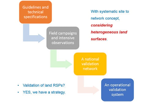
2. Validation Strategy
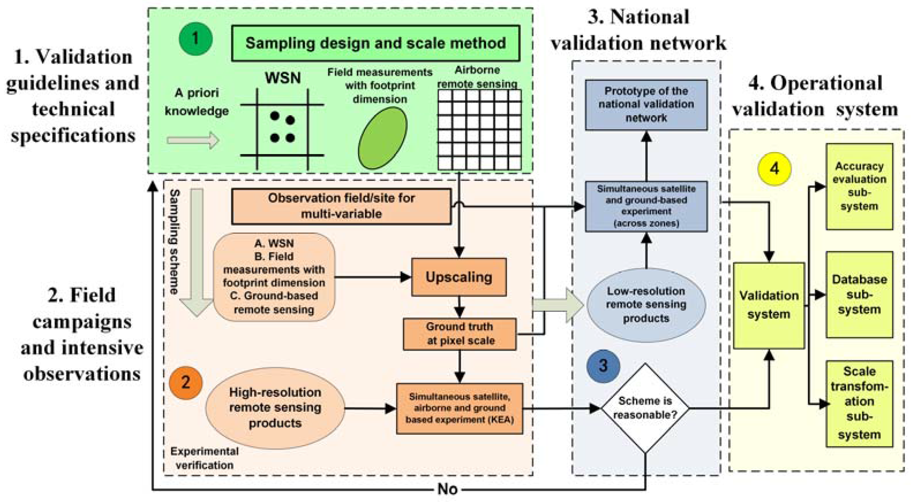
3. Validation Guidelines and Technical Specifications
3.1. Products of Interest
- Continuous product. This type of variable features continuously varying values in time and space at each grid. Aggregating ground measurements into the satellite pixel scale can be performed using conventional spatial sampling methods (such as simple random sampling, systematic sampling, and stratified sampling). In addition, the aggregated value is a weighted sum of all samples, in which the sample weight is determined by the sampling method.
- Categorical product. The value of each grid of this type of product is usually assigned as a group name instead of magnitudes and numbers in order or size. Pixel scale values can also be validated by ground-based spatial sampling, while the aggregation methods differ from those used for the continuous products.
3.2. Validation Guidelines and Technical Specifications
3.2.1. Validation Guidelines
- Validation criteria include accuracy, precision, completeness, temporal variation, spatial pattern, spatial and temporal consistency.
- Validation metrics, such as bias, mean absolute error (MAE), root mean square error (RMSE), mean absolute percent error (MAPE) and correlation coefficient R.
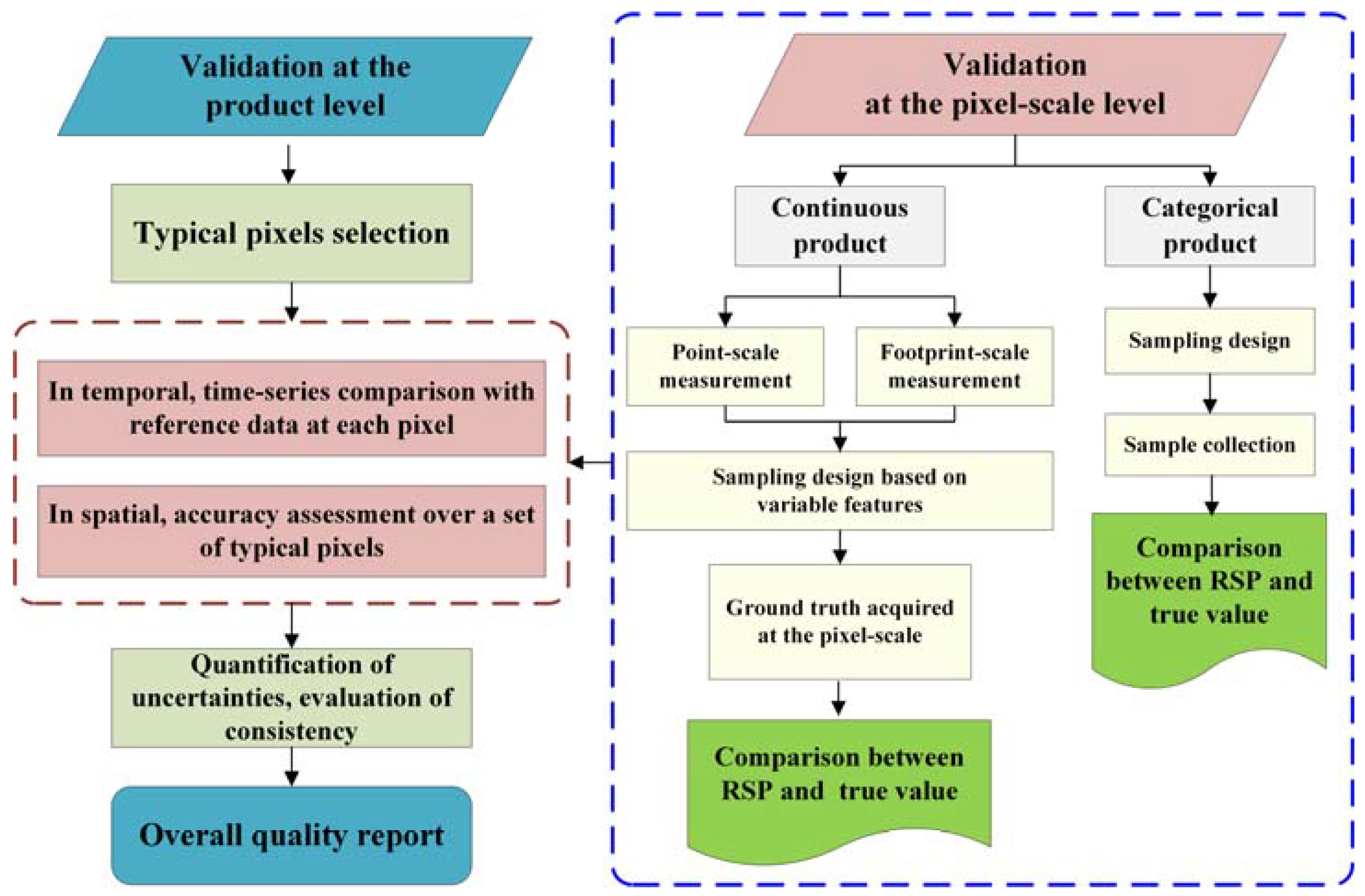
- Basic procedures and approaches used to validate either continuous or categorical RSPs are provided at the pixel scale level and at the product level, as illustrated in Figure 2.
- -
- Basic procedures and approaches used to validate continuous RSPs at the pixel scale level. In this aspect, direct validation can capitalise on in situ measurements collected at the point scale and/or footprint scale (e.g., EC system). Because both the location and number of sampling points can directly affect the reliability of pixel scale representative estimates, ground sampling design is conducted based on variables characteristics with the aid of geostatistical methods, such as the mean of the surface with non-homogeneity (MSN) [162,163]. In the upscaling process, ground truth at the pixel scale is derived through integrating in situ measurements, such as various kriging models. Then, the upscaled ground measurements can be used to compare against RSP.
- -
- Basic procedures and approaches used to validate categorical land RSPs at the pixel scale level are similar to the ones validating continuous RSPs. Ground sampling design also plays an important role in this process. For instance, in direct validation, ground measurements acquired at sampling points can be used to compare against remote sensing estimates.
- -
- Basic procedures and approaches used to validate land RSPs at the product level. The first is to select typical sites, pixels and time periods across different biomes and landscapes. Next, in temporal, product accuracy should be assessed via comparison against time series reference data at the pixel scale over each specific site. On this basis, in spatial, product accuracy should be further assessed over a widely distributed set of locations. Finally, overall evaluation of an RSP can be achieved by combining the assessed results acquired at both time and space. The spatial and temporal consistency and uncertainty of a product can then be well evaluated and quantified via independent measurements over wildly representative locations and time periods.
- General guidance on field site selection and corresponding ground instrumentation. This aspect suggests detailed criteria on how to choose or build a proper validation site and how to deploy various instruments to acquire high-quality ground measurements. Primarily, a site should be spatially representative of a given biome/ecosystem, considering national physiographic conditions. Basic observation facilities are also needed, including meteorology (e.g., precipitation and air temperature), eco-hydrological elements (e.g., soil temperature and moisture) and flux measurements. Other selection principles should be considered, e.g., accessibility, site extent, ambient environment, and commitment to long-term scientific study.
3.2.2. Validation Technical Specifications
- Validation criteria are data completeness, product accuracy, spatial and temporal variation, spatial and temporal consistency.
- Validation metrics are bias, RMSE, MAPE, mean relative error (MRE) and R.
- Procedures and approaches used in direct validation include the following: The first step is the acquisition of ground truth. At the watershed/regional scale, based on the measurements of water budget components (e.g., precipitation, runoff), water balance equation can be used to calculate yearly averaged ET result as ground truth. At small (point-, footprint- and pixel-) scales, direct flux measurements from Lysimeter, EC system and LAS, etc. are recommended. In the second step, at the river basin/watershed scale, spatial and temporal characteristics of long-term ET estimates are evaluated. At small scales, the accuracy of remotely sensed ET with instantaneous and daily/monthly averaged values as well as temporal variability are evaluated. Error sources and uncertainties are quantitatively assessed.
- Procedures and approaches used in indirect validation are the following: The goal of indirect validation is to validate ET estimates derived from low resolution (e.g., MODIS, NOAA/AVHRR pixel level) satellite observations. This involves using ground-based measurements and multi-source remote sensing information with different levels of spatial resolution, which is capitalised on a step-by-step concept, ranging from high resolution (e.g., airborne mission), medium resolution (e.g., Landsat, ASTER pixel level) to low spatial resolution, considering scaling effect correction in the upscaling process.
- Procedures and approaches used in inter-comparison are the following: Given multiple ET products, well-studied products can be used to evaluate others in need of validation. Evaluation process biases are observed when assessing product accuracy and consistency, spatial and temporal characteristics and regional applicability. In terms of multiple ET estimation models, the same input data (e.g., RS observations and forcing data) are used to drive different ET estimation models. Apart from assessing the accuracy and spatial-temporal characteristic of derived results, the validation process also compares the impact caused by diverse model structures, mechanisms and parameterization schemes, etc., to acquire knowledge regarding the applicability, limitation, and uncertainty of different models.
- Ground instruments are recommended, such as Lysimeter, EC system, and LAS as well as related measuring protocols and data processing instructions.
- Finally, an evaluation report should be generated with respect to the above validation efforts and product performance.
3.3. Progress on the Development of Sampling Design and Scale Approach
3.3.1. Sampling Design
3.3.2. Scaling Methods
4. Validation Activities at Reference Sites
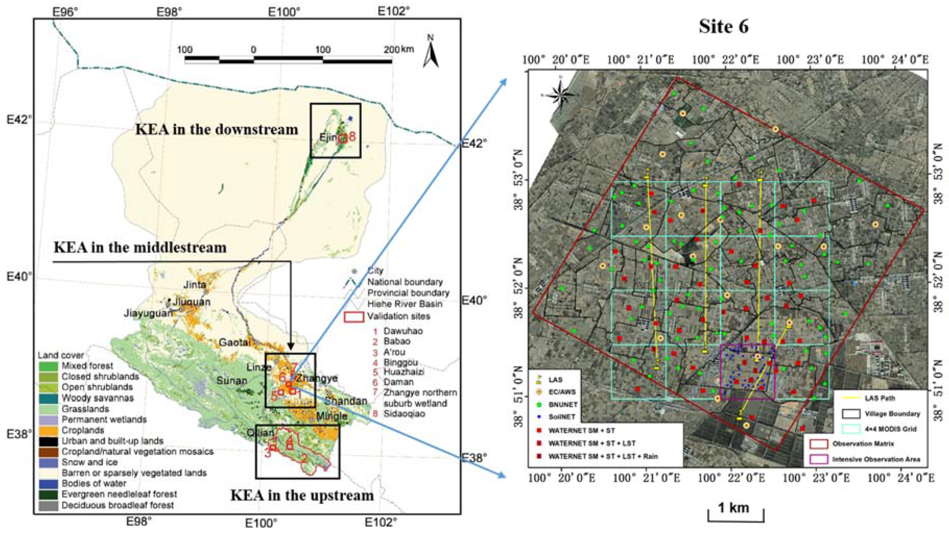
4.1. Validation Efforts in HiWATER
4.2. Other Validation Experiments
5. A National Validation Network and an Operational Validation System
5.1. National Network for Validating RSP
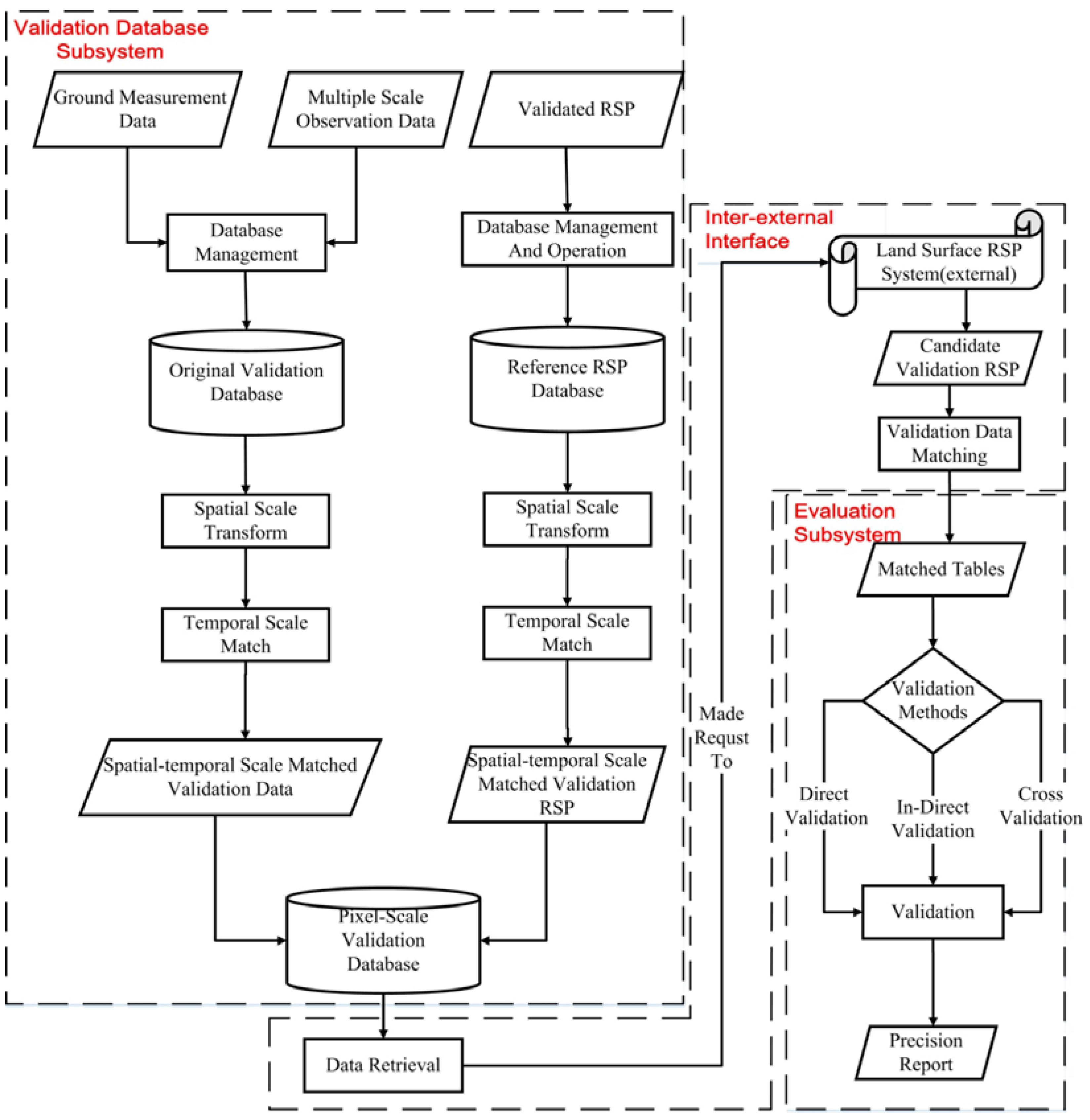
5.2. An Operational RSP Validation System
6. Conclusions
Acknowledgments
Author Contributions
Conflicts of Interest
References
- National Research Council (NRC); Committee on Scientific Accomplishments of Earth Observations from Space. Earth Observations from Space: The First 50 Years of Scientific Achievements; National Academies Press: Washington, DC, USA, 2008; p. 142.
- De Jeu, R.A.M.; Wagner, W.; Holmes, T.R.H.; Dolman, A.J.; van de Giesen, N.C.; Friesen, J. Global soil moisture patterns observed by space borne microwave radiometers and scatterometers. Surv. Geophys. 2008, 29, 399–420. [Google Scholar] [CrossRef] [Green Version]
- Zhao, X.; Liang, S.; Liu, S.; Yuan, W.; Xiao, Z.; Liu, Q.; Cheng, J.; Zhang, X.; Tang, H.; Zhang, X.; et al. The Global Land Surface Satellite (GLASS) remote sensing data processing system and products. Remote Sens. 2013, 5, 2436–2450. [Google Scholar] [CrossRef]
- Field, C.B.; Randerson, J.T.; Malmstrom, C.M. Global net primary production: Combining ecology and remote sensing. Remote Sens. Environ. 1995, 51, 74–88. [Google Scholar] [CrossRef]
- Running, S.W.; Nemani, R.R.; Heinsch, F.A.; Zhao, M.; Reeves, M.; Hashimoto, H. A continuous satellite-derived measure of global terrestrial primary production. Bioscience 2004, 54, 547–560. [Google Scholar] [CrossRef]
- Baret, F.; Hagolle, O.; Geiger, B.; Bicheron, P.; Miras, B.; Huc, M.; Berthelot, B.; Nino, F.; Weiss, M.; Samain, O.; et al. LAI, fAPAR and fCover CYCLOPES global products derived from VEGETATION—Part 1: Principles of the algorithm. Remote Sens. Environ. 2007, 110, 275–286. [Google Scholar] [CrossRef] [Green Version]
- Justice, C.O.; Townshend, J.R.G.; Vermote, E.F.; Masuoka, E.; Wolfe, R.E.; Saleous, N.; Roy, D.P.; Morisette, J.T. An overview of MODIS Land data processing and product status. Remote Sens. Environ. 2002, 83, 3–15. [Google Scholar] [CrossRef]
- Ganguly, S.; Nemani, R.R.; Zhang, G.; Hashimoto, H.; Milesi, C.; Michaelis, A.; Wang, W.L.; Votava, P.; Samanta, A.; Melton, F.; et al. Generating global Leaf Area Index from Landsat: Algorithm formulation and demonstration. Remote Sens. Environ. 2012, 122, 185–202. [Google Scholar] [CrossRef]
- Mu, Q.Z.; Zhao, M.S.; Running, S.W. Improvements to a MODIS global terrestrial evapotranspiration algorithm. Remote Sens. Environ. 2011, 115, 1781–1800. [Google Scholar] [CrossRef]
- Myneni, R.B.; Hoffman, S.; Knyazikhin, Y.; Privette, J.L.; Glassy, J.; Tian, Y.; Wang, Y.; Song, X.; Zhang, Y.; Smith, G.R.; et al. Global products of vegetation leaf area and fraction absorbed PAR from year one of MODIS data. Remote Sens. Environ. 2002, 83, 214–231. [Google Scholar] [CrossRef]
- Wan, Z. New refinements and validation of the MODIS land surface temperature/emissivity products. Remote Sens. Environ. 2008, 112, 59–74. [Google Scholar] [CrossRef]
- Hall, D.K.; Riggs, G.A.; Salomonson, V.V.; DiGirolamob, N.E.; Bayrd, K.J. MODIS snow-cover products. Remote Sens. Environ. 2002, 83, 181–194. [Google Scholar] [CrossRef]
- Schaaf, C.B.; Gao, F.; Strahler, A.H.; Lucht, W.; Li, X.; Tsang, T.; Strugnell, N.C.; Zhang, X.; Jin, Y.; Muller, J.P.; et al. First operational BRDF, albedo and nadir reflectance products from MODIS. Remote Sens. Environ. 2002, 83, 135–148. [Google Scholar] [CrossRef]
- Justice, C.O.; Belward, A.; Morisette, J.; Lewis, P.; Baret, F. Developments in the ‘validation’ of satellite sensor products for the study of the land surface. Int. J. Remote Sens. 2000, 21, 3382–3390. [Google Scholar] [CrossRef]
- Zhang, R.H.; Tian, J.; Li, Z.L.; Su, H.B.; Chen, S.H.; Tang, X.Z. Principles and methods for the validation of quantitative remote sensing products. Sci. China Earth Sci. 2010, 53, 741–751. [Google Scholar] [CrossRef]
- Rondeaux, G.; Steven, M.D.; Clark, J.A.; Mackay, G. La Crau: A European test site for remote sensing validation. Int. J. Remote Sens. 1998, 19, 2775–2788. [Google Scholar] [CrossRef]
- Su, Z.; Wen, J.; Dente, L.; van der Velde, R.; Wang, L.; Ma, Y.M.; Yang, K.; Hu, Z.Y. The Tibetan Plateau observatory of plateau scale soil moisture and soil temperature (Tibet-Obs) for quantifying uncertainties in coarse resolution satellite and model products. Hydrol. Earth Syst. Sci. 2011, 15, 2303–2316. [Google Scholar] [CrossRef]
- Yang, K.; Qin, J.; Zhao, L.; Chen, Y.Y.; Tang, W.J.; Han, M.L.; Lazhu; Chen, Z.Q.; Lv, N.; Ding, B.H.; et al. A multiscale soil moisture and freeze–thaw monitoring network on the third pole. Bull. Am. Meteorl. Soc. 2013, 94, 1907–1916. [Google Scholar] [CrossRef]
- Morisette, J.T.; Privette, J.L.; Justice, C.O. A framework for the validation of MODIS land products. Remote Sens. Environ. 2002, 83, 77–96. [Google Scholar] [CrossRef]
- CEOS Land Product Validation Web Site. Available online: http://lpvs.gsfc.nasa.gov/ (accessed on 2 May 2014).
- Baldocchi, D.; Falge, E.; Gu, L.H.; Olson, R.; Hollinger, D.; Running, S.; Anthoni, P.; Bernhofer, C.; Davis, K.; Evans, R.; et al. FLUXNET: A new tool to study the temporal and spatial variability of ecosystem–scale carbon dioxide, water vapor, and energy flux densities. Bull. Am. Meteorl. Soc. 2001, 82, 2415–2434. [Google Scholar] [CrossRef]
- Dorigo, W.A.; Wagner, W.; Hohensinn, R.; Hahn, S.; Paulik, C.; Xaver, A.; Gruber, A.; Drusch, M.; Mecklenburg, S.; van Oevelen, P.; et al. The International Soil Moisture Network: A data hosting facility for global in situ soil moisture measurements. Hydrol. Earth Syst. Sci. 2011, 15, 1675–1698. [Google Scholar] [CrossRef]
- Schaefer, G.L.; Cosh, M.H.; Jackson, T.J. The USDA natural resources conservation service soil climate analysis network (SCAN). J. Atmos. Ocean. Technol. 2007, 24, 2073–2077. [Google Scholar] [CrossRef]
- Sellers, P.; Hall, F.; Margolis, H.; Kelly, B.; Baldocchi, D.; Denhartog, G.; Cihlar, J.; Ryan, M.G.; Goodison, B.; Crill, P.; et al. The Boreal Ecosystem–Atmosphere Study (BOREAS): An overview and early results from the 1994 field year. Bull. Am. Meteorl. Soc. 1995, 76, 1549–1577. [Google Scholar] [CrossRef]
- Cline, D.; Davis, R.E.; Edelstein, W.; Hilland, J.; McDonald, K.; Running, S.; Way, J.; van Zyl, J. Cold Land Processed Mission (EX-7) Technology Implementation Plan. In Proceedings of the NASA Post-2002 Land Surface Hydrology Planning Workshop, Irvine, CA, USA, 12–14 April 1999.
- Tian, X.; Li, Z.Y.; Chen, E.X.; Liu, Q.H.; Yan, G.J.; Wang, J.D.; Niu, Z.; Zhao, S.J.; Li, X.; Pang, Y.; et al. The Complicate Observations and Multi-Parameter Land Information Constructions on Allied Telemetry Experiment (COMPLICATE). PLoS ONE 2015, 10, e0137545. [Google Scholar] [CrossRef] [PubMed]
- Goutorbe, J.P.; Lebel, T.; Tinga, A.; Bessemoulin, P.; Brouwer, J.; Dolman, A.J.; Engman, E.T.; Gash, J.; Hoepffner, M.; Kabat, P.; et al. HAPEX-SAHEL: A large-scale study of land-atmosphere interactions in the semiarid tropics. Ann. Geophys. 1994, 12, 53–64. [Google Scholar] [CrossRef]
- Sellers, P.J.; Hall, F.G.; Asrar, G.; Strebel, D.E.; Murphy, R.E. An overview of the 1st international satellite land surface climatology project (ISLSCP) field experiment (FIFE). J. Geophys. Res. 1992, D17, 18345–18371. [Google Scholar] [CrossRef]
- Jackson, T.J.; Bindlish, R.; Gasiewski, A.J.; Stankov, B.; Klein, M.; Njoku, E.G.; Bosch, D.; Coleman, T.L.; Laymon, C.; Starks, P. Polarimetric scanning radiometer C and X band microwave observations during SMEX03. IEEE Trans. Geosci. Remote Sens. 2005, 43, 2418–2430. [Google Scholar] [CrossRef]
- Baret, F.; Weiss, M.; Leroy, M.; Allard, D.; Garrigues, S.; Bohbot, H.; Bosseno, R.; Bella, C.D.; Espana, M.; Gond, V.; et al. VALERI: A Network of Sites and a Methodology for the Validation of Land Satellite Products [Online]. 2003. Available online: http://w3.avignon.inra.fr/valeri/documents/ (accessed on 13 March 2013).
- Li, X.; Cheng, G.D.; Liu, S.M.; Xiao, Q.; Ma, M.G.; Jin, R.; Che, T.; Liu, Q.H.; Wang, W.Z.; Qi, Y.; et al. Heihe watershed allied telemetry experimental research (HiWATER): Scientific objectives and experimental design. Bull. Am. Meteorol. Soc. 2013, 94, 1145–1160. [Google Scholar] [CrossRef]
- Houghton, J.; Townshend, J.; Dawson, K.; Mason, P.; Zillman, J.; Simmons, A. The GCOS at 20 years: The origin, achievement and future development of the Global Climate Observing System. Weather 2012, 67, 227–235. [Google Scholar] [CrossRef]
- Anderson, S.A.; Bales, R.C.; Duffy, C.J. Critical Zone Observatories: Building a network to advance interdisciplinary study of Earth surface processes. Mineral. Mag. 2008, 72, 7–10. [Google Scholar] [CrossRef]
- Bogena, H.; Schulz, K.; Vereecken, H. Towards a network of observatories in terrestrial environmental research. Adv. Geosci. 2006, 9, 109–114. [Google Scholar] [CrossRef]
- Nickeson, J.E.; Morisette, J.T.; Privette, J.L.; Justice, C.O.; Wickland, D.E. Coordinating Earth observing system land validation. Eos. Trans. AGU 2007, 88, 81–82. [Google Scholar] [CrossRef]
- Turner, D.P.; Cohen, W.B.; Kennedy, R.E.; Fassnacht, K.S.; Briggs, J.M. Relationships between leaf area index and Landsat TM spectral vegetation indices across three temperate zone sites. Remote Sens. Environ. 1999, 70, 52–68. [Google Scholar] [CrossRef]
- Baret, F.; Morissette, J.T.; Fernandes, R.A.; Champeaux, J.L.; Myneni, R.B.; Chen, J.; Plummer, S.; Weiss, M.; Bacour, C.; Garrigues, S.; et al. Evaluation of the representativeness of networks of sites for the global validation and intercomparison of land biophysical products: Proposition of the CEOS-BELMANIP. IEEE Trans. Geosci. Remote Sens. 2006, 44, 1794–1803. [Google Scholar] [CrossRef]
- Tian, Y.H.; Woodcock, C.E.; Wang, Y.J.; Privette, J.L.; Shabanova, N.V.; Zhou, L.M.; Zhang, Y.; Buermann, W.; Dong, J.R.; Veikkanen, B.; et al. Multiscale analysis and validation of the MODIS LAI product—II. Sampling strategy. Remote Sens. Environ. 2002, 83, 431–441. [Google Scholar] [CrossRef]
- Burakowski, E.A.; Ollinger, S.V.; Lepine, L.; Schaaf, C.B.; Wang, Z.S.; Dibb, J.E.; Hollinger, D.Y.; Kim, J.; Erb, A.; Martin, M. Spatial scaling of reflectance and surface albedo over a mixed-use, temperate forest landscape during snow-covered periods. Remote Sens. Environ. 2015, 158, 465–477. [Google Scholar] [CrossRef]
- Jackson, T.J.; Bindlish, R.; Cosh, M.H.; Zhao, T.J.; Starks, P.J.; Bosch, D.D.; Seyfried, M.; Moran, M.S.; Goodrich, D.C.; Kerr, Y.H.; et al. Validation of soil moisture and ocean salinity (SMOS) soil moisture over watershed networks in the U.S. IEEE Trans. Geosci. Remote Sens. 2012, 50, 1530–1543. [Google Scholar] [CrossRef] [Green Version]
- Baret, F.; Camacho, F.; Fang, H.; Garrigues, S.; Gobron, N.; Lang, M.; Lacaze, R.; LeBlanc, S.; Meroni, M.; Martinez, B.; et al. Global Leaf Area Index Product Validation Good Practices; Version 2.0; Fernandes, R., Plummer, S., Nightingale, J., Eds.; Satellite-Derived Land Product Validation, Land Product Validation Subgroup (WGCV/CEOS): Zurich, Switzerland, 2014; p. 76. [Google Scholar] [CrossRef]
- Held, A.; Phinn, S.; Soto-Berelov, M.; Jones, S. (Eds.) AusCover Good Practice Guidelines: A Technical Handbook Supporting Calibration and Validation Activities of Remotely Sensed Data Products; Version 1.2; TERN AusCover: Canberra, Australia, 2015.
- Morisette, J.T.; Baret, F.; Privette, J.L.; Myneni, R.B.; Nickeson, J.E.; Garrigues, S.; Shabanov, N.V.; Weiss, M.; Fernandes, R.A.; Leblanc, S.G.; et al. Validation of global moderate resolution LAI Products: A framework proposed within the CEOS Land Product Validation subgroup. IEEE Trans. Geosci. Remote Sens. 2006, 44, 1804–1817. [Google Scholar] [CrossRef]
- Crow, W.T.; Berg, A.A.; Cosh, M.H.; Loew, A.; Mohanty, B.P.; Panciera, R.; de Rosnay, P.; Ryu, D.; Walker, J.P. Upscaling sparse ground-based soil moisture observations for the validation of coarse-resolution satellite soil moisture products. Rev. Geophys. 2012, 50, RG2002. [Google Scholar] [CrossRef]
- Cescatti, A.; Marcolla, B.; Vannan, S.K.S.; Pan, J.Y.; Román, M.O.; Yang, X.Y.; Ciais, P.; Cook, R.B.; Law, B.E.; Matteucci, G.; et al. Intercomparison of MODIS albedo retrievals and in situ measurements across the global FLUXNET network. Remote Sens. Environ. 2012, 121, 323–334. [Google Scholar] [CrossRef]
- Liang, S.; Fang, H.; Chen, M.; Shuey, C.; Walthall, C.; Daughtry, C.; Morisette, J.; Schaaf, C.; Strahler, A. Validating MODIS land surface reflectance and albedo products: Methods and preliminary results. Remote Sens. Environ. 2002, 83, 149–162. [Google Scholar] [CrossRef]
- Stroeve, J.; Box, J.E.; Gao, F.; Liang, S.; Nolin, A.; Schaaf, B.C. Accuracy assessment of the MODIS 16-day snow albedo product: Comparisons with Greenland in situ measurements. Remote Sens. Environ. 2005, 94, 46–60. [Google Scholar] [CrossRef]
- Stroeve, J.; Box, J.E.; Wang, Z.S.; Schaaf, C.; Barrett, A. Re-evaluation of MODIS MCD43 Greenland albedo accuracy and trends. Remote Sens. Environ. 2013, 138, 199–214. [Google Scholar] [CrossRef]
- Wang, K.; Liu, J.; Zhou, X.; Sparrow, M.; Ma, M.; Sun, Z.; Jiang, W. Validation of the MODIS global land surface albedo product using ground measurements in a semidesert region on the Tibetan Plateau. J. Geophys. Res. 2004, 109, D05107. [Google Scholar] [CrossRef]
- Wang, Z.; Schaaf, C.B.; Strahler, A.H.; Chopping, M.J.; Román, M.O.; Shuai, Y.; Woodcock, C.E.; Hollinger, D.Y.; Fitzjarrald, D.R. Evaluation of MODIS albedo product (MCD43A) over grassland, agriculture and forest surface types during dormant and snow-covered periods. Remote Sens. Environ. 2014, 140, 60–77. [Google Scholar] [CrossRef]
- Wang, Z.; Schaaf, C.B.; Chopping, M.J.; Strahler, A.H.; Wang, J.; Román, M.O.; Rocha, A.V.; Woodcock, C.E.; Shuai, Y. Evaluation of Moderate-resolution Imaging Spectroradiometer (MODIS) snow albedo product (MCD43A) over tundra. Remote Sens. Environ. 2012, 117, 264–280. [Google Scholar] [CrossRef]
- Wright, P.; Bergin, M.; Dibb, J.; Lefer, B.; Domine, F.; Carman, T.; Carmagnola, C.; Dumont, M.; Courville, Z.; Schaaf, C.; et al. Comparing MODIS daily snow albedo to spectral albedo field measurements in Central Greenland. Remote Sens. Environ. 2014, 140, 118–129. [Google Scholar] [CrossRef]
- Peng, J.J.; Liu, Q.; Wen, J.G.; Liu, Q.H.; Tang, Y.; Wang, L.Z.; Dou, B.C.; You, D.Q.; Sun, C.K.; Zhao, X.J. Multi-scale validation strategy for satellite albedo products and its uncertainty analysis. Sci. China Earth Sci. 2015, 58, 573–588. [Google Scholar] [CrossRef]
- Wu, X.; Xiao, Q.; Wen, J.; Liu, Q.; You, D.; Dou, B.; Tang, Y.; Li, X. Optimal nodes selectiveness from WSN to fit field scale albedo observation and validation in long time series in the FOCI experiment areas, Heihe. Remote Sens. 2015, 7, 14757–14780. [Google Scholar] [CrossRef]
- Hulley, G.C.; Hook, S.J. Intercomparison of versions 4, 4.1 and 5 of the MODIS land surface temperature and emissivity products and validation with laboratory measurements of sand samples from the Namib desert, Namibia. Remote Sens. Environ. 2009, 113, 1313–1318. [Google Scholar] [CrossRef]
- Hulley, G.C.; Hook, S.J.; Baldridge, A.M. Validation of the North American ASTER Land Surface Emissivity Database (NAALSED) version 2.0 using pseudo-invariant sand dune sites. Remote Sens. Environ. 2009, 113, 2224–2233. [Google Scholar] [CrossRef]
- Li, Z.L.; Becker, F.; Stoll, M.P.; Wan, Z.M. Evaluation of six methods for extracting relative emissivity spectra from thermal infrared images. Remote Sens. Environ. 1999, 69, 197–214. [Google Scholar] [CrossRef]
- Wan, Z.M. New refinements and validation of the collection-6 MODIS land-surface temperature/emissivity product. Remote Sens. Environ. 2014, 140, 36–45. [Google Scholar] [CrossRef]
- Wang, K.C.; Liang, S.L. Evaluation of ASTER and MODIS land surface temperature and emissivity products using long-term surface longwave radiation observations at SURFRAD sites. Remote Sens. Environ. 2009, 113, 1556–1565. [Google Scholar] [CrossRef]
- Wang, K.; Wan, Z.; Wang, P.; Sparrow, M.; Liu, J.; Haginoya, S. Evaluation and improvement of the MODIS land surface temperature/emissivity products using ground-based measurements at a semi-desert site on the western Tibetan Plateau. Int. J. Remote Sens. 2007, 28, 2549–2565. [Google Scholar] [CrossRef]
- Kim, H.W.; Hwang, K.; Mu, Q.; Lee, S.O.; Choi, M. Validation of MODIS 16 global terrestrial evapotranspiration products in various climates and land cover types in Asia. KSCE J. Civ. Eng. 2012, 16, 229–238. [Google Scholar] [CrossRef]
- Mueller, B.; Seneviratne, S.I.; Jimenez, C.; Corti, T.; Hirschi, M.; Balsamo, G.; Ciais, P.; Dirmeyer, P.; Fisher, J.B.; Guo, Z. Evaluation of global observations-based evapotranspiration datasets and IPCC AR4 simulations. Geophys. Res. Lett. 2011, 38. [Google Scholar] [CrossRef]
- Tang, R.L.; Li, Z.L.; Tang, B.H. An application of the Ts–VI triangle method with enhanced edges determination for evapotranspiration estimation from MODIS data in arid and semi-arid regions: Implementation and validation. Remote Sens. Environ. 2010, 114, 540–551. [Google Scholar] [CrossRef]
- Tang, R.L.; Shao, K.; Li, Z.L.; Wu, H.; Tang, B.H.; Zhou, G.Q.; Zhang, L. Multiscale validation of the 8-day MOD16 evapotranspiration product using flux data collected in China. IEEE J. Sel. Top. Appl. Remote Sens. 2015, 8, 1478–1486. [Google Scholar] [CrossRef]
- Tang, R.L.; Li, Z.L.; Chen, K.S. Validating MODIS-derived land surface evapotranspiration with in situ measurements at two AmeriFlux sites in a semiarid region. J. Geophys Res. 2011, 116. [Google Scholar] [CrossRef]
- Liu, S.M.; Xu, Z.W.; Zhu, Z.L.; Jia, Z.Z.; Zhu, M.J. Measurements of evapotranspiration from eddy-covariance systems and large aperture scintillometers in the Hai River Basin, China. J. Hydrol. 2013, 487, 24–38. [Google Scholar] [CrossRef]
- Jia, Z.Z.; Liu, S.M.; Xu, Z.W.; Chen, Y.J.; Zhu, M.J. Validation of remotely sensed evapotranspiration over the Hai River Basin, China. J. Geophys. Res. 2012, 117, D13113. [Google Scholar] [CrossRef]
- Xu, Z.W.; Liu, S.M.; Li, X.; Shi, S.J.; Wang, J.M.; Zhu, Z.L.; Xu, T.R.; Wang, W.Z.; Ma, M.G. Intercomparison of surface energy flux measurement systems used during the HiWATER-MUSOEXE. J. Geophys. Res. 2013, 118, 13140–13157. [Google Scholar] [CrossRef]
- Song, L.S.; Liu, S.M.; Zhang, X.; Zhou, J.; Li, M.S. Estimating and validating soil evaporation and crop transpiration during the HiWATER-MUSOEXE. IEEE Geosci. Remote Sens. Lett. 2015, 12, 334–338. [Google Scholar] [CrossRef]
- Song, L.S.; Liu, S.M.; Kustas, W.P.; Zhou, J.; Xu, Z.W.; Xia, T.; Li, M.S. Application of remote sensing-based two source energy balance model for mapping field surface fluxes with composite and component surface temperatures. Agric. For. Meteorol. 2016, 230–231, 8–19. [Google Scholar] [CrossRef]
- Ge, Y.; Liang, Y.Z.; Wang, J.H.; Zhao, Q.Y.; Liu, S.M. Upscaling sensible heat fluxes with area-to-area regression kriging. IEEE Geosci. Remote Sens. Lett. 2015, 12, 656–660. [Google Scholar]
- Liu, S.M.; Xu, Z.W.; Song, L.S.; Zhao, Q.Y.; Ge, Y.; Xu, T.R.; Ma, Y.F.; Zhu, Z.L.; Jia, Z.Z.; Zhang, F. Upscaling evapotranspiration measurements from multi-site to the satellite pixel scale over heterogeneous land surfaces. Agric. For. Meteorol. 2016, 230–231, 97–113. [Google Scholar]
- Liu, S.M.; Xu, Z.W.; Song, L.S.; Zhang, Y.; Zhu, Z.L. A framework for validating remotely sensed evapotranspiration. In Proceedings of the IGARSS 2016, Beijing, China, 10–15 July 2016.
- Bai, J.; Jia, L.; Liu, S.M.; Xu, Z.W.; Hu, G.C.; Zhu, M.J.; Song, L.S. Characterizing the footprint of eddy covariance system and large aperture scintillometer measurements to validate satellite-based surface fluxes. IEEE Geosci. Remote Sens. Lett. 2015, 12, 943–947. [Google Scholar]
- Bacour, C.; Baret, F.; Beal, D.; Weiss, M.; Pavageau, K. Neural network estimation of LAI, fAPAR, fCover and LAIxC(ab), from top of canopy MERIS reflectance data: Principles and validation. Remote Sens. Environ. 2006, 105, 313–325. [Google Scholar] [CrossRef]
- Baret, F.; Weiss, M.; Lacaze, R.; Camacho, F.; Makhmara, H.; Pacholcyzk, P.; Smets, B. GEOV1: LAI and FAPAR essential climate variables and FCOVER global time series capitalizing over existing products. Part1: Principles of development and production. Remote Sens. Environ. 2013, 137, 299–309. [Google Scholar] [CrossRef]
- Camacho, F.; Cernicharo, J.; Lacaze, R.; Baret, F.; Weiss, M. GEOV1: LAI, FAPAR essential climate variables and FCOVER global time series capitalizing over existing products. Part 2: Validation and intercomparison with reference products. Remote Sens. Environ. 2013, 137, 310–329. [Google Scholar] [CrossRef]
- Weiss, M.; Baret, F.; Garrigues, S.; Lacaze, R.; Bicheron, P. LAI, fAPAR and fCover CYCLOPES global products derived from VEGETATION. Part 2: Validation and comparison with MODIS Collection 4 products. Remote Sens. Environ. 2007, 110, 317–331. [Google Scholar] [CrossRef]
- Steinberg, D.C.; Goetz, S.J.; Hyer, E. Validation of MODIS FAPAR products in boreal forests of Alaska. IEEE Trans. Geosci. Remote Sens. 2006, 44, 1818–1828. [Google Scholar] [CrossRef]
- Weiss, M.; Baret, F.; Block, T.; Koetz, B.; Burini, A.; Scholze, B.; Lecharpentier, P.; Brockmann, C.; Fernandes, R.; Plummer, S.; et al. On line validation exercise (OLIVE): A web based service for the validation of medium resolution land products. Application to FAPAR products. Remote Sens. 2014, 6, 4190–4216. [Google Scholar] [CrossRef]
- Wang, L.; Fan, W.J.; Xu, X.R.; Liu, Y. Scaling transform method for remotely sensed FAPAR based on FAPAR-P model. IEEE Geosci. Remote Sensing Lett. 2015, 12, 706–710. [Google Scholar] [CrossRef]
- Wang, Y.; Xie, D.; Liu, S.; Hu, R.; Li, Y.; Yan, G. Scaling of FAPAR from the field to the satellite. Remote Sens. 2016, 8, 310. [Google Scholar] [CrossRef]
- Mu, X.; Hu, M.; Song, W.; Ruan, G.; Ge, Y.; Wang, J.; Huang, S.; Yan, G. Evaluation of sampling methods for validation of remotely sensed fractional vegetation cover. Remote Sens. 2015, 7, 16164–16182. [Google Scholar] [CrossRef]
- Garrigues, S.; Lacaze, R.; Baret, F.; Morisette, J.T.; Weiss, M.; Nickeson, J.E.; Fernandes, R.; Plummer, S.; Shabanov, N.V.; Myneni, R.B.; et al. Validation and intercomparison of global Leaf Area Index products derived from remote sensing data. J. Geophys. Res. 2008, 113, G02028. [Google Scholar] [CrossRef]
- Yang, W.; Tan, B.; Huang, D.; Rautiainen, M.; Shabanov, N.V.; Wang, Y.; Privette, J.L.; Huemmrich, K.F.; Fensholt, R.; Sandholt, I.; et al. MODIS leaf area index products: From validation to algorithm improvement. IEEE Trans. Geosci. Remote Sens. 2006, 44, 1885–1898. [Google Scholar] [CrossRef]
- Li, Z.W.; Tang, H.; Xin, X.P.; Zhang, B.H.; Wang, D.L. Assessment of the MODIS LAI product using ground measurement data and HJ-1A/1B imagery in the meadow steppe of Hulunber, China. Remote Sens. 2014, 6, 6242–6265. [Google Scholar] [CrossRef]
- Zeng, Y.L.; Li, J.; Liu, Q.H.; Li, L.H.; Xu, B.D.; Yin, G.F.; Peng, J.J. A sampling strategy for remotely sensed LAI product validation over heterogeneous land surface. IEEE J. Sel. Top. Appl. Remote Sens. 2014, 7, 3128–3142. [Google Scholar] [CrossRef]
- Zeng, Y.L.; Li, J.; Liu, Q.; Qu, Y.H.; Huete, A.R.; Xu, B.D.; Yin, G.F.; Zhao, J. An optimal sampling design for observing and validating long-term leaf area index with temporal variations in spatial heterogeneities. Remote Sens. 2015, 7, 1300–1319. [Google Scholar] [CrossRef]
- Qu, Y.H.; Zhu, Y.Q.; Han, W.C.; Wang, J.D.; Ma, M.G. Crop leaf area index observations with a wireless sensor network and its potential for validating remote sensing products. IEEE J. Sel. Top. Appl. Remote Sens. 2014, 7, 431–444. [Google Scholar] [CrossRef]
- Shi, Y.C.; Wang, J.D.; Qin, J.; Qu, Y.H. An upscaling algorithm to obtain the representative ground truth of LAI time series in heterogeneous land surface. Remote Sens. 2015, 7, 12887–12908. [Google Scholar] [CrossRef]
- Coll, C.; Wan, Z.; Galve, J.M. Temperature-based and radiance-based validations of the V5 MODIS land surface temperature product. J. Geophys. Res. 2009, 114, D20102. [Google Scholar] [CrossRef]
- Wan, Z.; Zhang, Y.; Zhang, Q.; Li, Z.L. Quality assessment and validation of the MODIS global land surface. Int. J. Remote Sens. 2004, 25, 261–274. [Google Scholar] [CrossRef]
- Wan, Z.; Zhang, Y.; Zhang, Q.; Li, Z.L. Validation of the land surface temperature products retrieved from Terra Moderate Resolution Imaging Spectroradiometer data. Remote Sens. Environ. 2002, 83, 163–180. [Google Scholar] [CrossRef]
- Jiang, J.; Li, H.; Liu, Q.; Wang, H.; Du, Y.; Cao, B.; Zhong, B.; Wu, S. Evaluation of land surface temperature retrieval from FY-3B/VIRR data in an arid area of northwestern China. Remote Sens. 2015, 7, 7080–7104. [Google Scholar] [CrossRef]
- Yu, W.P.; Ma, M.G. Scale mismatch between in situ and remote sensing observations of land surface temperature: Implications for the validation of remote sensing LST products. IEEE Geosci. Remote Sens. Lett. 2015, 12, 497–501. [Google Scholar]
- Yu, W.P.; Ma, M.G.; Wang, X.F.; Tan, J.L. Validation of the MODIS LST products using long wave radiation ground measurements in the north arid region of China. Remote Sens. 2014, 6, 11494–11517. [Google Scholar] [CrossRef]
- Li, H.; Sun, D.L.; Yu, Y.Y.; Wang, H.Y.; Liu, Y.L.; Liu, Q.H.; Du, Y.M.; Wang, H.S.; Cao, B. Evaluation of the VIIRS and MODIS LST products in an arid area of Northwest China. Remote Sens. Environ. 2014, 142, 111–121. [Google Scholar] [CrossRef]
- Zhou, J.; Li, M.; Liu, S.M.; Jia, Z.Z.; Ma, Y.F. Validation and performance evaluations of methods for estimating land surface temperatures from ASTER data in the middle reach of the Heihe River Basin, Northwest China. Remote Sens. 2015, 7, 7126–7156. [Google Scholar] [CrossRef]
- Jiang, B.; Liang, S.L.; Ma, H.; Zhang, X.T.; Xiao, Z.Q.; Zhao, X.; Jia, K.; Yao, Y.J.; Jia, A.L. GLASS daytime all-wave net radiation product: Algorithm development and preliminary validation. Remote Sens. 2016, 8, 222. [Google Scholar] [CrossRef]
- Jia, A.L.; Jiang, B.; Liang, S.L.; Zhang, X.T.; Ma, H. Validation and Spatiotemporal Analysis of CERES Surface Net Radiation Product. Remote Sens. 2016, 8, 90. [Google Scholar] [CrossRef]
- Inamdar, A.K.; Guillevic, P.C. Net surface shortwave radiation from GOES imagery-product evaluation using ground-based measurements from SURFRAD. Remote Sens. 2015, 7, 10788–10814. [Google Scholar] [CrossRef]
- Pan, X.; Liu, Y.B.; Fan, X.W. Comparative assessment of satellite-retrieved surface net radiation: An examination on CERES and SRB datasets in China. Remote Sens. 2015, 7, 4899–4918. [Google Scholar] [CrossRef]
- Mira, M.; Olioso, A.; Gallego-Elvira, B.; Courault, D.; Garrigues, S.; Marloie, O.; Hagolle, O.; Guillevic, P.; Boulet, G. Uncertainty assessment of surface net radiation derived from Landsat images. Remote Sens. Environ. 2016, 175, 251–270. [Google Scholar] [CrossRef]
- Huang, G.H.; Li, X.; Huang, C.L.; Liu, S.M.; Ma, Y.F.; Chen, H. Representativeness errors of point-scale ground-based solar radiation measurements in the validation of remote sensing products. Remote Sens. Environ. 2016, 181, 198–206. [Google Scholar] [CrossRef]
- Huang, G.H.; Li, X.; Ma, M.G.; Li, H.Y.; Huang, C.L. High resolution surface radiation products for studies of regional energy, hydrologic and ecological processes over Heihe River Basin, northwest China. Agric. For. Meteorol. 2016. [Google Scholar] [CrossRef]
- Reich, P.B.; Turner, D.P.; Bolstad, P. An approach to spatially distributed modeling of net primary production (NPP) at the landscape scale and its application in validation of EOS NPP products. Remote Sens. Environ. 1999, 70, 69–81. [Google Scholar] [CrossRef]
- Turner, D.P.; Ritts, W.D.; Cohen, W.B.; Gower, S.T.; Zhao, M.; Running, S.W.; Wofsy, S.C.; Urbanski, S.; Dunn, A.L.; Munger, J.W. Scaling gross primary production (GPP) over boreal and deciduous forest landscapes in support of MODIS GPP product validation. Remote Sens. Environ. 2003, 88, 256–270. [Google Scholar] [CrossRef]
- Turner, D.P.; Ollinger, S.; Smith, M.L.; Krankina, O.; Gregory, M. Scaling net primary production to a MODIS footprint in support of Earth observing system product validation. Int. J. Remote Sens. 2004, 25, 1961–1979. [Google Scholar] [CrossRef]
- Turner, D.P.; Ritts, W.D.; Cohen, W.B.; Maeirsperger, T.K.; Gower, S.T.; Kirschbaum, A.A.; Running, S.W.; Zhao, M.S.; Wofsy, S.C.; Dunn, A.L. Site-level evaluation of satellite-based global terrestrial gross primary production and net primary production monitoring. Glob. Chang. Biol. 2005, 11, 666–684. [Google Scholar] [CrossRef]
- Clark, D.A.; Brown, S.; Kicklighter, D.W.; Chambers, J.Q.; Thomlinson, J.R.; Ni, J.; Holland, E.A. Net primary production in tropical forests: An evaluation and synthesis of existing field data. Ecol. Appl. 2001, 11, 371–384. [Google Scholar] [CrossRef]
- Wang, X.F.; Ma, M.G.; Li, X. Validation of MODIS GPP product at ten flux sites in northern China. Int. J. Remote Sens. 2013, 34, 587–599. [Google Scholar] [CrossRef]
- Wang, J.H.; Ge, Y.; Heuvelink, G.B.M.; Zhou, C.H. Spatial sampling design for estimating regional GPP with spatial heterogeneities. IEEE Geosci. Remote Sens. Lett. 2014, 11, 539–543. [Google Scholar] [CrossRef]
- Ran, Y.H.; Li, X.; Zhang, L.; Kljun, N.; Sun, R.; Wang, X.F.; Zhu, G.F. Spatial representativeness and uncertainty of eddy covariance carbon flux measurement for upscaling net ecosystem productivity to field scale. Agric. For. Meteorol. 2016, in press. [Google Scholar]
- Calders, K.; Schenkels, T.; Bartholomeus, H.; Armston, J.; Verbesselt, J.; Herold, M. Monitoring spring phenology with high temporal resolution terrestrial LiDAR measurements. Remote Sens. Environ. 2015, 203, 158–168. [Google Scholar] [CrossRef]
- Klosterman, S.T.; Hufkens, K.; Gray, J.M.; Melaas, E.; Sonnentag, O.; Lavine, I.; Mitchell, L.; Norman, R.; Friedl, M.A.; Richardson, A.D. Evaluating remote sensing of deciduous forest phenology at multiple spatial scales using PhenoCam imagery. Biogeosciences 2014, 11, 4305–4320. [Google Scholar] [CrossRef]
- Sakamoto, T.; Yokozawa, M.; Toritani, H.; Shibayama, M.; Ishitsuka, N.; Ohno, H. A crop phenology detection method using time-series MODIS data. Remote Sens. Environ. 2005, 96, 366–374. [Google Scholar] [CrossRef]
- Zhang, X.Y.; Friedl, M.A.; Schaaf, C.B.; Strahler, A.H.; Hodges, J.C.F.; Gao, F.; Reed, B.C.; Huete, A. Monitoring vegetation phenology using MODIS. Remote Sens. Environ. 2003, 84, 471–475. [Google Scholar] [CrossRef]
- Parajka, J.; Bloschl, G. Validation of MODIS snow cover images over Austria. Hydrol. Earth Syst. Sci. 2006, 10, 679–689. [Google Scholar] [CrossRef]
- Klein, A.G.; Barnett, A.C. Validation of daily MODIS snow cover maps of the Upper Rio Grande River Basin for the 2000–2001 snow year. Remote Sens. Environ. 2003, 86, 162–176. [Google Scholar] [CrossRef]
- Salomonson, V.V.; Appel, I. Development of the Aqua MODIS NDSI fractional snow cover algorithm and validation results. IEEE Trans. Geosci. Remote Sens. 2006, 44, 1747–1756. [Google Scholar] [CrossRef]
- Simic, A.; Fernandes, R.; Brown, R.; Romanov, P.; Park, W. Validation of VEGETATION, MODIS, and GOES + SSM/I snow-cover products over Canada based on surface snow depth observations. Hydrol. Process. 2004, 18, 1089–1104. [Google Scholar] [CrossRef]
- Hall, D.K.; Riggs, G.A. Accuracy assessment of the MODIS snow cover products. Hydrol. Process. 2007, 21, 1534–1547. [Google Scholar] [CrossRef]
- Maurer, E.P.; Rhoads, J.D.; Dubayah, R.O.; Lettenmaier, D.P. Evaluation of the snow-covered area data product from MODIS. Hydrol. Process. 2003, 17, 59–71. [Google Scholar] [CrossRef]
- Bi, Y.; Xie, H.; Huang, C.; Ke, C. Snow cover variations and controlling factors at upper Heihe River Basin, Northwestern China. Remote Sens. 2015, 7, 6741–6762. [Google Scholar] [CrossRef]
- Hou, J.L.; Huang, C.L. Improving mountainous snow cover fraction mapping via artificial neural networks combined with MODIS and ancillary topographic data. IEEE Trans. Geosci. Remote Sens. 2014, 52, 5601–5611. [Google Scholar]
- Li, H.Y.; He, Y.Q.; Hao, X.H.; Che, T.; Wang, J.; Huang, X.D. Downscaling snow cover fraction data in mountainous regions based on simulated inhomogeneous snow ablation. Remote Sens. 2015, 7, 8995–9019. [Google Scholar] [CrossRef]
- Bavera, D.; De Michele, C. Snow water equivalent estimation in the Mallero basin using snow gauge data and MODIS images and fieldwork validation. Hydrol. Process. 2009, 23, 1961–1972. [Google Scholar] [CrossRef]
- Anderton, S.P.; White, S.M.; Alvera, B. Evaluation of spatial variability in snow water equivalent for a high mountain catchment. Hydrol. Process. 2004, 18, 435–453. [Google Scholar] [CrossRef]
- Derksen, C.; Walker, A.; Goodison, B. Evaluation of passive microwave snow water equivalent retrievals across the boreal forest/tundra transition of western Canada. Remote Sens. Environ. 2005, 96, 315–327. [Google Scholar] [CrossRef]
- Derksen, C.; Toose, P.; Lemmetyinen, J.; Pulliainen, J.; Langlois, A.; Rutter, N.; Fuller, M.C. Evaluation of passive microwave brightness temperature simulations and snow water equivalent retrievals through a winter season. Remote Sens. Environ. 2012, 117, 236–248. [Google Scholar] [CrossRef]
- Dressler, K.A.; Leavesley, G.H.; Bales, R.C.; Fassnacht, S.R. Evaluation of gridded snow water equivalent and satellite snow cover products for mountain basins in a hydrologic model. Hydrol. Process. 2006, 20, 673–688. [Google Scholar] [CrossRef]
- Che, T.; Dai, L.Y.; Wang, J.; Zhao, K.; Liu, Q. Estimation of snow depth and snow water equivalent distribution using airborne microwave radiometry in the Binggou Watershed, the upper reaches of the Heihe River Basin. Int. J. Appl. Earth Obs. 2012, 17. [Google Scholar] [CrossRef]
- Brocca, L.; Hasenauer, S.; Lacava, T.; Melone, F.; Moramarco, T.; Wagner, W.; Dorigo, W.; Matgen, P.; Martinez-Fernandez, J.; Llorens, P. Soil moisture estimation through ASCAT and AMSR-E sensors: An intercomparison and validation study across Europe. Remote Sens. Environ. 2011, 115, 3390–3408. [Google Scholar] [CrossRef]
- Dorigo, W.A.; Gruber, A.; de Jeu, R.A.M.; Wagner, W.; Stacke, T.; Loew, A.; Albergel, C.; Brocca, L.; Chung, D.; Parinussa, R.M.; et al. Evaluation of the ESA CCI soil moisture product using ground-based observations. Remote Sens. Environ. 2015, 162, 380–395. [Google Scholar] [CrossRef]
- Jackson, T.J.; Cosh, M.H.; Bindlish, R.; Starks, P.J.; Bosch, D.D.; Seyfried, M.; Goodrich, D.C.; Moran, M.S.; Du, J. Validation of advanced microwave scanning radiometer soil moisture products. IEEE Trans. Geosci. Remote Sens. 2010, 48, 4256–4272. [Google Scholar] [CrossRef]
- Wagner, W.; Hahn, S.; Kidd, R.; Melzer, T.; Bartalis, Z.; Hasenauer, S.; Figa-Saldaña, J.; de Rosnay, P.; Jann, A.; Schneider, S.; et al. The ASCAT soil moisture product: A review of its specifications, validation results, and emerging applications. Meteorol. Z. 2013, 22, 5–33. [Google Scholar] [CrossRef]
- Feng, H.; Liu, Y.; Wu, G. Temporal variability of uncertainty in pixel-wise soil moisture: Implications for satellite validation. Remote Sens. 2015, 7, 5398–5415. [Google Scholar] [CrossRef]
- Jin, R.; Li, X.; Yan, B.P.; Li, X.H.; Luo, W.M.; Ma, M.G.; Guo, J.W.; Kang, J.; Zhu, Z.L.; Zhao, S.J. A nested ecohydrological wireless sensor network for capturing the surface heterogeneity in the midstream areas of the Heihe River Basin, China. IEEE Geosci. Remote Sens. Lett. 2014, 11, 2015–2019. [Google Scholar] [CrossRef]
- Kang, J.; Li, X.; Jin, R.; Ge, Y.; Wang, J.F.; Wang, J.H. Hybrid optimal design of the eco-hydrological wireless sensor network in the middle reach of the Heihe River Basin, China. Sensors 2014, 14, 19095–19114. [Google Scholar] [CrossRef] [PubMed]
- Kang, J.; Jin, R.; Li, X. Regression kriging-based upscaling of soil moisture measurements from a wireless sensor network and multiresource remote sensing information over heterogeneous cropland. IEEE Geosci. Remote Sens. Lett. 2015, 12, 92–96. [Google Scholar] [CrossRef]
- Wang, J.H.; Ge, Y.; Song, Y.Z.; Li, X. A geostatistical approach to upscale soil moisture with unequal precision observations. IEEE Geosci. Remote Sens. Lett. 2014, 11, 2125–2129. [Google Scholar] [CrossRef]
- Wang, J.H.; Ge, Y.; Heuvelink, G.B.M.; Zhou, C. Upscaling in situ soil moisture observations to pixel averages with spatio-temporal geostatistics. Remote Sens. 2015, 7, 11372–11388. [Google Scholar] [CrossRef]
- Chander, G.; Groeneveld, D.P. Intra-annual NDVI validation of the Landsat 5 TM radiometric calibration. Int. J. Remote Sens. 2009, 30, 1621–1628. [Google Scholar] [CrossRef]
- Simoniello, T.; Cuomo, V.; Lanfredi, M.; Lasaponara, R.; Macchiato, M. On the relevance of accurate correction and validation procedures in the analysis of AVHRR-NDVI time series for long-term monitoring. J. Geophys. Res. 2004, 109. [Google Scholar] [CrossRef]
- Haboudane, D.; Miller, J.R.; Pattey, E.; Zarco-Tejada, P.J.; Strachan, I. Hyperspectral vegetation indices and novel algorithms for predicting green LAI of crop canopies: Modeling and validation in the context of precision agriculture. Remote Sens. Environ. 2004, 90, 337–352. [Google Scholar] [CrossRef]
- Gao, X.; Huete, A.R.; Didan, K. Multisensor comparisons and validation of MODIS vegetation indices at the semiarid Jornada experimental range. IEEE Trans. Geosci. Remote Sens. 2003, 41, 2368–2381. [Google Scholar]
- Meng, J.H.; Wu, B.F.; Chen, X.Y.; Du, X.; Niu, L.M.; Zhang, F.F. Validation of HJ-1 B charge-coupled device vegetation index products with spectral reflectance of Hyperion. Int. J. Remote Sens. 2011, 32, 9051–9070. [Google Scholar] [CrossRef]
- Geng, L.Y.; Ma, M.G.; Yu, W.P.; Wang, X.F.; Jia, S.Z. Validation of the MODIS NDVI products in different land-use types using in situ measurements in the Heihe River Basin. IEEE Geosci. Remote Sens. Lett. 2014, 11, 1649–1653. [Google Scholar] [CrossRef]
- Ding, Y.L.; Zhao, K.; Zheng, X.M.; Jiang, T. Temporal dynamics of spatial heterogeneity over cropland quantified by time-series NDVI, near infrared and red reflectance of Landsat 8 OLI imagery. Int. J. Appl. Earth Obs. 2014, 30, 139–145. [Google Scholar] [CrossRef]
- Wulder, M.A.; White, J.C.; Magnussen, S.; McDonald, S. Validation of a large area land cover product using purpose-acquired airborne video. Remote Sens. Environ. 2007, 106, 480–491. [Google Scholar] [CrossRef]
- Foody, G.M.; Boyd, D.S. Using volunteered data in land cover map validation: Mapping west African forests. IEEE J. Sel. Top. Appl. Remote Sens. 2013, 6, 1305–1312. [Google Scholar] [CrossRef]
- Bai, Y.; Feng, M.; Jiang, H.; Wang, J.L.; Liu, Y.Z. Validation of land cover maps in China using a sampling-based labeling approach. Remote Sens. 2015, 7, 10589–10606. [Google Scholar] [CrossRef]
- Shi, W.Z.; Zhang, X.K.; Hao, M.; Shao, P.; Cai, L.P.; Lyu, X.Z. Validation of land cover products using reliability evaluation methods. Remote Sens. 2015, 7, 7846–7864. [Google Scholar] [CrossRef]
- Ran, Y.H.; Li, X.; Lu, L. Evaluation of four remote sensing based land cover products over China. Int. J. Remote Sens. 2010, 31, 391–401. [Google Scholar] [CrossRef]
- Hu, X.L.; Lu, L.; Li, X.; Wang, J.H.; Guo, M. Land use/cover change in the middle reaches of the Heihe River Basin over 2000–2011 and its implications for sustainable water resource management. PLoS ONE 2015, 10. [Google Scholar] [CrossRef] [PubMed]
- Zhong, B.; Yang, A.X.; Nie, A.H.; Yao, Y.J.; Zhang, H.; Wu, S.L.; Liu, Q.H. Finer resolution land-cover mapping using multiple classifiers and multisource remotely sensed data in the Heihe River Basin. IEEE J. Sel. Top. Appl. Remote Sens. 2015, 8, 4973–4992. [Google Scholar] [CrossRef]
- Zhang, T.; Armstrong, R.L.; Smith, J. Investigation of the near-surface soil freeze-thaw cycle in the contiguous United States: Algorithm development and validation. J. Geophys. Res. 2003, 108. [Google Scholar] [CrossRef]
- Eitzinger, J.; Parton, W.J.; Hartman, M. Improvement and validation of a daily soil temperature submodel for freezing/thawing periods. Soil Sci. 2000, 165, 525–534. [Google Scholar] [CrossRef]
- Entekhabi, D.; Njoku, E.G.; Houser, P.; Spencer, M.; Doiron, T.; Kim, Y.J.; Smith, J.; Girard, R.; Belair, S.; Crow, W. The hydrosphere state (Hydros) satellite mission: An earth system pathfinder for global mapping of soil moisture and land freeze/thaw. IEEE Trans. Geosci. Remote Sens. 2004, 42, 2184–2195. [Google Scholar] [CrossRef]
- Han, M.L.; Yang, K.; Qin, J.; Jin, R.; Ma, Y.M.; Wen, J.; Chen, Y.Y.; Zhao, L.; Zhu, L.; Tang, W.J. An algorithm based on the standard deviation of passive microwave brightness temperatures for monitoring soil surface freeze/thaw state on the Tibetan Plateau. IEEE Trans. Geosci. Remote Sens. 2015, 53, 2775–2783. [Google Scholar] [CrossRef]
- Ge, Y.; Li, X.; Hu, M.G.; Wang, J.H.; Jin, R.; Wang, J.F.; Zhang, R.H. Technical specification for the validation of remote sensing products. Int. Arch. Photogramm. Remote Sens. Spat. Inf. Sci. 2013, XL-2/W1, 13–17. [Google Scholar] [CrossRef]
- Wang, J.F.; Christakos, G.; Hu, M.G. Modeling spatial means of surfaces with stratified non-homogeneity. IEEE Trans. Geosci. Remote Sens. 2009, 47, 4167–4174. [Google Scholar] [CrossRef]
- Hu, M.G.; Wang, J.F. A spatial sampling optimization package using MSN theory. Environ. Model. Softw. 2011, 26, 546–548. [Google Scholar] [CrossRef]
- Ge, Y.; Wang, J.H.; Heuvelink, G.B.M.; Jin, R.; Li, X.; Wang, J.F. Sampling design optimization of a wireless sensor network for monitoring ecohydrological processes in the Babao River basin, China. Int. J. Geogr. Inf. Sci. 2014. [Google Scholar] [CrossRef]
- You, D.; Wen, J.; Xiao, Q.; Liu, Q.; Liu, Q.; Tang, Y.; Dou, B.; Peng, J. Development of a high resolution BRDF/Albedo product by fusing airborne CASI reflectance with MODIS daily reflectance in the oasis area of the Heihe River Basin, China. Remote Sens. 2015, 7, 6784–6807. [Google Scholar] [CrossRef]
- Li, X.; Jin, R.; Liu, S.M.; Ge, Y.; Xiao, Q.; Liu, Q.H.; Ma, M.G.; Ran, Y.H. Upscaling researches in HiWATER: Progresses and prospects. J. Remote Sens. 2016. [Google Scholar] [CrossRef]
- Cheng, G.D.; Li, X.; Zhao, W.Z.; Xu, Z.M.; Feng, Q.; Xiao, S.C.; Xiao, H.L. Integrated study of the water-ecosystem-economy in the Heihe River Basin. Natl. Sci. Rev. 2014, 1, 413–428. [Google Scholar] [CrossRef]
- Han, X.J.; Jin, R.; Li, X.; Wang, S.G. Soil moisture estimation using Cosmic-Ray soil moisture sensing at heterogeneous farmland. IEEE Geosci. Remote Sens. Lett. 2014, 11, 1659–1663. [Google Scholar]
- Ma, M.G.; Che, T.; Li, X.; Xiao, Q.; Zhao, K.; Xin, X.P. A prototype network for remote sensing validation in China. Remote Sens. 2015, 7, 5187–5202. [Google Scholar] [CrossRef]


| Types of RSPs | Variables | RS Observation Method | Spatial Resolution | Previous Studies | Our Validation Efforts (Basic Information and References) |
|---|---|---|---|---|---|
| Continuous product | Albedo | VNIR * | 30 m–1 km | [39,45,46,47,48,49,50,51,52] | Multi-scale validation strategy for satellite albedo products [53]; Optimal nodes selectiveness from WSN to fit field scale albedo observation and validation [54] |
| Emissivity | TIR | 90 m–1 km | [11,55,56,57,58,59,60] | N/A | |
| ET | VNIR, TIR | 30 m–1 km | [61,62,63,64,65] | Measurements of ET from EC and LAS systems [66] and validation of remotely sensed ET [67] in the Hai River Basin; A flux observation matrix was established over the HRB [68]; Estimating and validating soil evaporation and crop transpiration [69,70]; Upscaling ET measurements from the field to larger scales [71,72]; A framework for validating remotely sensed ET [73]; Characterising the footprint of EC and LAS measurements to validate satellite-based surface fluxes [74] | |
| FAPAR | VNIR | 30 m–1 km | [75,76,77,78,79,80] | Scaling of remotely sensed and measured FAPAR [81,82] | |
| FCover | VNIR | 30 m–1 km | [75,76,77,78] | Evaluation of sampling methods for validation of remotely sensed FCover [83] | |
| LAI | VNIR, LiDAR | 30 m–1 km | [43,75,76,77,78,84,85] | Assessment of the MODIS LAI product in the meadow steppe [86]; Sampling strategy for observing and validating remotely sensed LAI product over heterogeneous land surface [87,88]; Development of a WSN used for validating LAI products [89]; Upscaling algorithm to obtain ground truth of LAI time series over heterogeneous land surface [90] | |
| LST | TIR | 90 m–1 km | [11,55,58,60,91,92,93] | Evaluation of LST retrieval from FY-3B/VIRR data [94]; Analysis of scale mismatch between in situ and remote sensing LST product [95]; Evaluation and validation of the MODIS LST in arid regions of China [96,97]; Validation of LST estimated from ASTER data in the HRB [98] | |
| Net radiation | VNIR, TIR | 30 m–1 km | [99,100,101,102,103] | Analysis of representativeness errors of point-scale ground-based solar radiation measurements in the validation of RSPs [104]; A framework to obtain high resolution surface radiation products [105] | |
| Continuous product | NPP | VNIR, LiDAR | 30 m–1 km | [106,107,108,109,110] | Validation of MODIS GPP product at ten flux sites in northern China [111]; Spatial sampling design for estimating regional GPP [112]; Analysis of spatial representativeness and uncertainty of flux measurement for upscaling ecosystem productivity to field scale [113] |
| Phenology | VNIR, LiDAR | 30 m–1 km | [114,115,116,117] | N/A | |
| Snow cover area | VNIR | 30 m–1 km | [118,119,120,121,122,123] | Analysis of snow cover variations and controlling factors at upper HRB [124]; Improving mountainous snow cover fraction mapping [125]; Downscaling snow cover fraction data in mountainous regions [126] | |
| Snow water equivalent | Passive microwave | 1–25 km | [127,128,129,130,131] | Estimation of snow depth and snow water equivalent distribution using airborne microwave radiometry [132] | |
| Soil moisture | Active/passive microwave | 1–25 km | [17,23,40,133,134,135,136] | Analysis of temporal variability of uncertainty in pixel-wise soil moisture [137]; Design and establishment of WSN for capturing soil moisture over heterogeneous land surface [138,139]; Upscaling in situ soil moisture observations to pixel averages [140,141,142] | |
| Vegetation index | VNIR | 30 m–1 km | [143,144,145,146,147] | Validation of the MODIS NDVI products in the HRB [148]; Analysis of temporal dynamics of spatial heterogeneity of NDVI [149] | |
| Categorical product | LUCC | VNIR | 30 m–1 km | [150,151,152,153,154] | LUCC in the middle reaches of the HRB over 2000-2011 [155]; Finer resolution land-cover mapping in the HRB [156] |
| Soil freeze/thaw status | Active/passive microwave | 1–25 km | [18,157,158,159] | Monitoring soil surface freeze/thaw state on the Tibetan Plateau [160] |
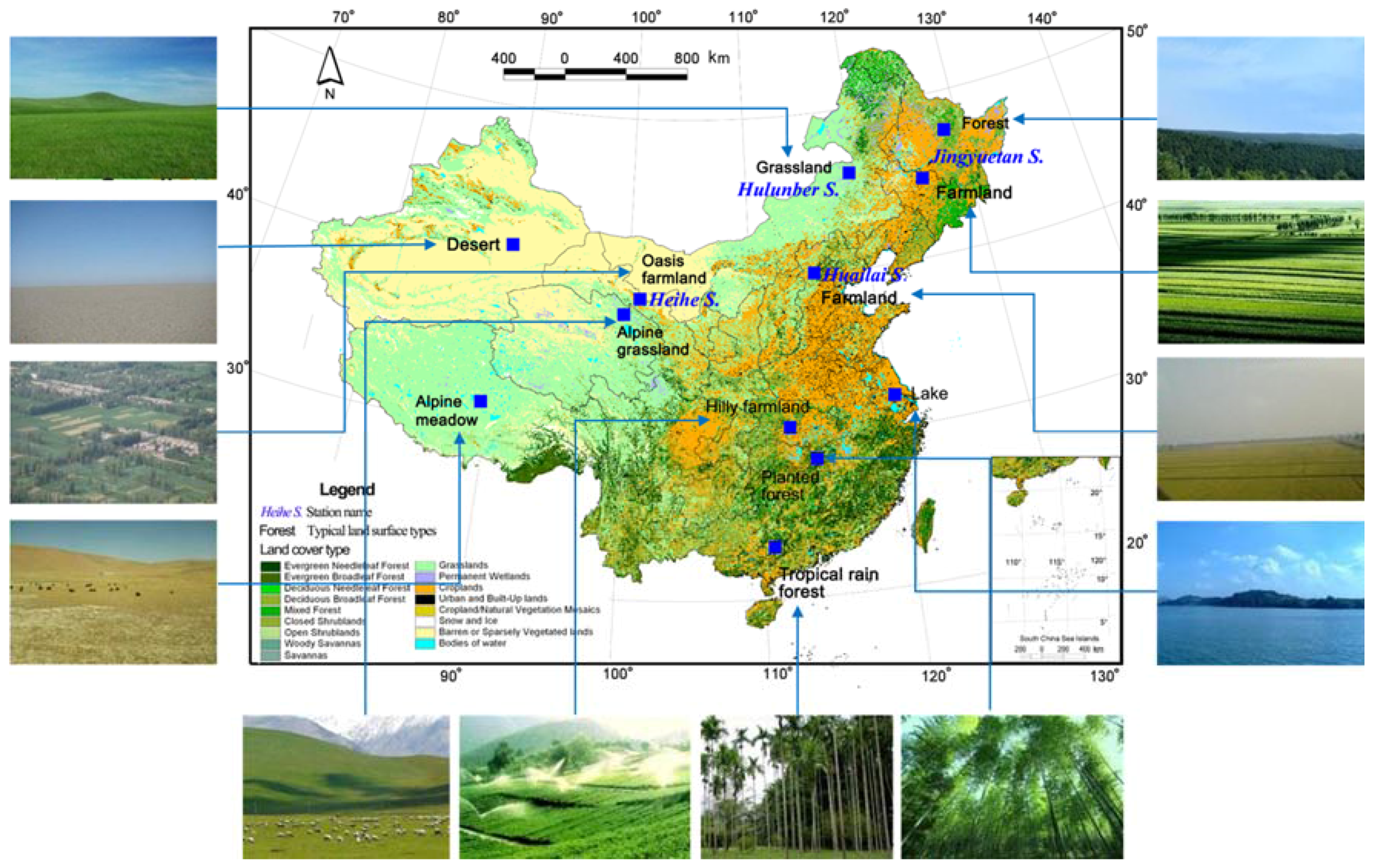
| Station Name | Core Site and Size | Location | Meteorology | Land Cover | Scientific Aims |
|---|---|---|---|---|---|
| Huailai Station | East garden controlled experimental site 100 m × 100 m | Prov.: Hebei; Long.: 115.783; Lat.: 40.349; Ele.: 488 | Precip.: 650; Temp.: 10 | Type: Cropland; LAI: 6.5 | Remote sensing mechanism; scale approach |
| East garden 1.5 km × 2 km | Prov.: Hebei; Long.: 115.783; Lat.: 40.349; Ele.: 488 | Precip.: 650; Temp.: 10 | Type: Cropland; LAI: 6.5 | Remote sensing mechanism; ecological protection; crop growth simulation model | |
| Guanting reservoir 2 km × 2 km | Prov.: Hebei; Long.: 115.740; Lat.: 40.352; Ele.: 475 | Precip.: 650; Temp.: 9 | Type: Water; LAI: 0 | Ecological protection; water resource utilization | |
| Jingyuetan Station | Taipingpu controlled experimental site 200 m × 200 m | Prov.: Jilin; Long.: 125.401; Lat.: 43.998; Ele.: 211 | Precip.: 520; Temp.: 4.4 | Type: Cropland; LAI: 4 | Radiative transfer theory; soil freeze/thaw process; scale approach |
| Dehui corn 2 km × 2 km | Prov.: Jilin; Long.: 125.360; Lat.: 44.119; Ele.: 207 | Precip.: 604; Temp.: 4.8 | Type: Cropland; LAI: 5 | Validation; water balance; crop simulation growth model | |
| Hulunber Station | Stipa baicalensis site 3 km × 3 km | Prov.: Inner Mongolia; Long.: 120.087; Lat.: 49.342; Ele.: 642 | Precip.: 380; Temp.: −1.0 | Type: Temperate meadow steppe; LAI: 2.5 | Validation; grassland ecosystem process model |
| Cropland site 3 km × 3 km | Prov.: Inner Mongolia; Long.: 120.034; Lat.: 49.308; Ele.: 638 | Precip.: 380; Temp.: −1.0 | Type: Cropland; LAI: 4 | Validation; crop simulation growth model |
© 2016 by the authors; licensee MDPI, Basel, Switzerland. This article is an open access article distributed under the terms and conditions of the Creative Commons Attribution (CC-BY) license (http://creativecommons.org/licenses/by/4.0/).
Share and Cite
Wang, S.; Li, X.; Ge, Y.; Jin, R.; Ma, M.; Liu, Q.; Wen, J.; Liu, S. Validation of Regional-Scale Remote Sensing Products in China: From Site to Network. Remote Sens. 2016, 8, 980. https://doi.org/10.3390/rs8120980
Wang S, Li X, Ge Y, Jin R, Ma M, Liu Q, Wen J, Liu S. Validation of Regional-Scale Remote Sensing Products in China: From Site to Network. Remote Sensing. 2016; 8(12):980. https://doi.org/10.3390/rs8120980
Chicago/Turabian StyleWang, Shuguo, Xin Li, Yong Ge, Rui Jin, Mingguo Ma, Qinhuo Liu, Jianguang Wen, and Shaomin Liu. 2016. "Validation of Regional-Scale Remote Sensing Products in China: From Site to Network" Remote Sensing 8, no. 12: 980. https://doi.org/10.3390/rs8120980
APA StyleWang, S., Li, X., Ge, Y., Jin, R., Ma, M., Liu, Q., Wen, J., & Liu, S. (2016). Validation of Regional-Scale Remote Sensing Products in China: From Site to Network. Remote Sensing, 8(12), 980. https://doi.org/10.3390/rs8120980