Article

Inversion of Land Surface Temperature (LST) Using Terra ASTER Data: A Comparison of Three Algorithms

Institute of Space and Earth Sciences, Anadolu University, Iki Eylul Campus, Eskisehir 26555, Turkey
*
Author to whom correspondence should be addressed.
Remote Sens. 2016, 8(12), 993; https://doi.org/10.3390/rs8120993
Submission received: 9 September 2016 / Revised: 28 October 2016 / Accepted: 23 November 2016 / Published: 2 December 2016

Abstract

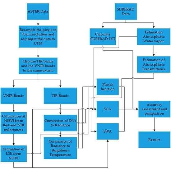
Land Surface Temperature (LST) is an important measurement in studies related to the Earth surface’s processes. The Advanced Space-borne Thermal Emission and Reflection Radiometer (ASTER) instrument onboard the Terra spacecraft is the currently available Thermal Infrared (TIR) imaging sensor with the highest spatial resolution. This study involves the comparison of LSTs inverted from the sensor using the Split Window Algorithm (SWA), the Single Channel Algorithm (SCA) and the Planck function. This study has used the National Oceanic and Atmospheric Administration’s (NOAA) data to model and compare the results from the three algorithms. The data from the sensor have been processed by the Python programming language in a free and open source software package (QGIS) to enable users to make use of the algorithms. The study revealed that the three algorithms are suitable for LST inversion, whereby the Planck function showed the highest level of accuracy, the SWA had moderate level of accuracy and the SCA had the least accuracy. The algorithms produced results with Root Mean Square Errors (RMSE) of 2.29 K, 3.77 K and 2.88 K for the Planck function, the SCA and SWA respectively.
Keywords: land surface temperature (LST); split window algorithm (SWA); single channel algorithm (SCA); thermal infrared (TIR); Planck function; python land surface temperature (LST); split window algorithm (SWA); single channel algorithm (SCA); thermal infrared (TIR); Planck function; python
Graphical Abstract