
Mapping Arctic Plant Functional Type Distributions in the Barrow Environmental Observatory Using WorldView-2 and LiDAR Datasets

 ,
, 
Abstract
:
1. Introduction
2. Methodology
2.1. Study Area and Datasets
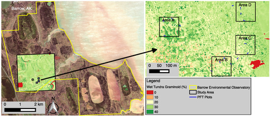
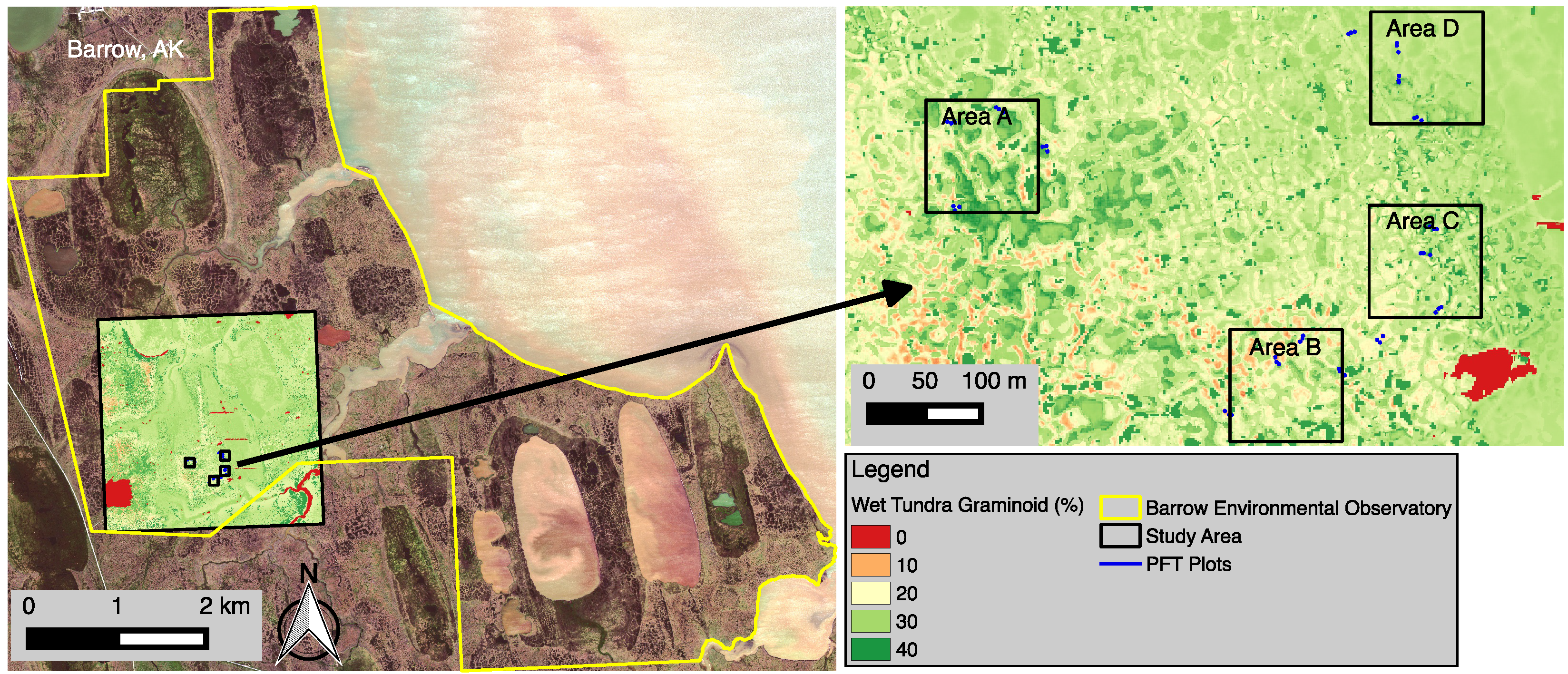
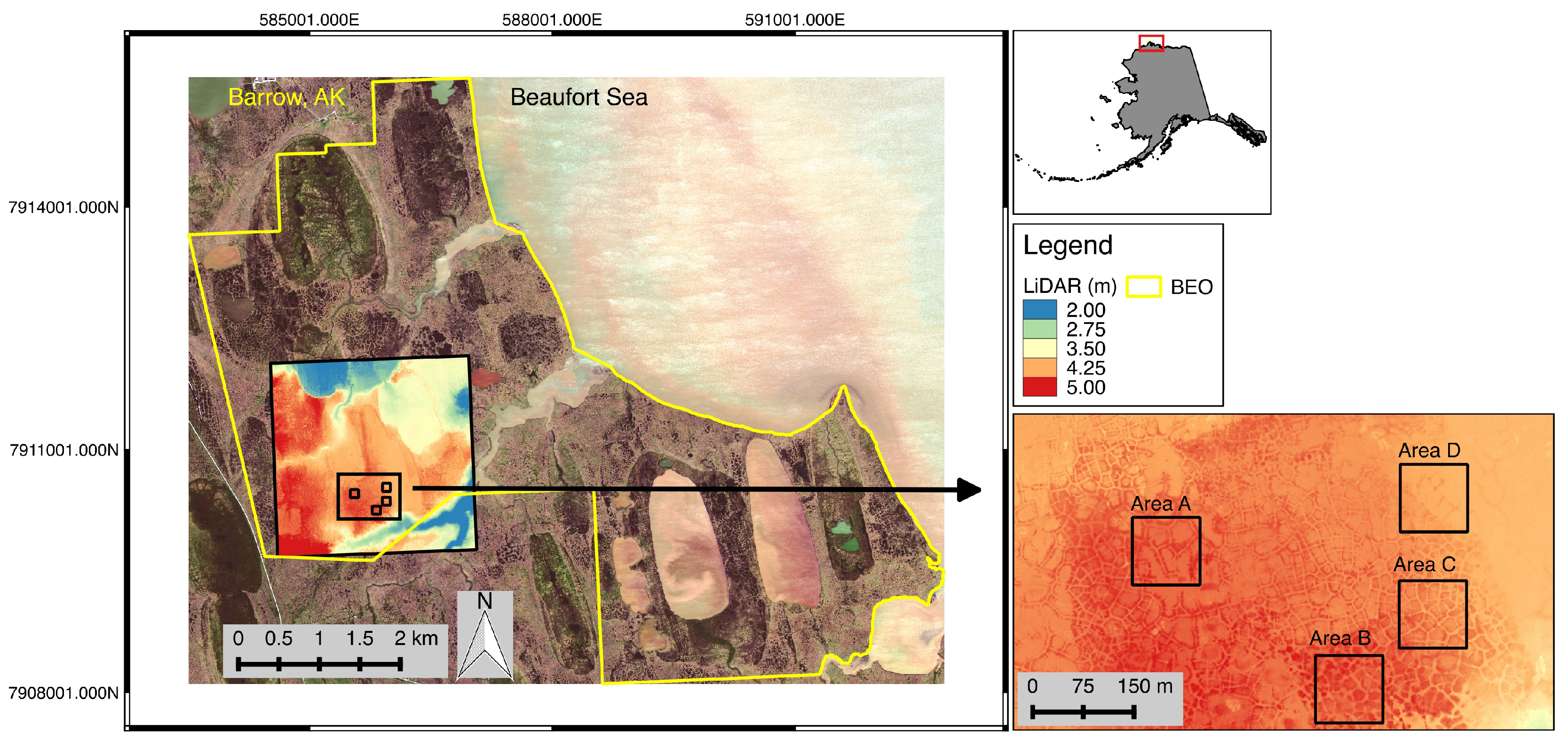
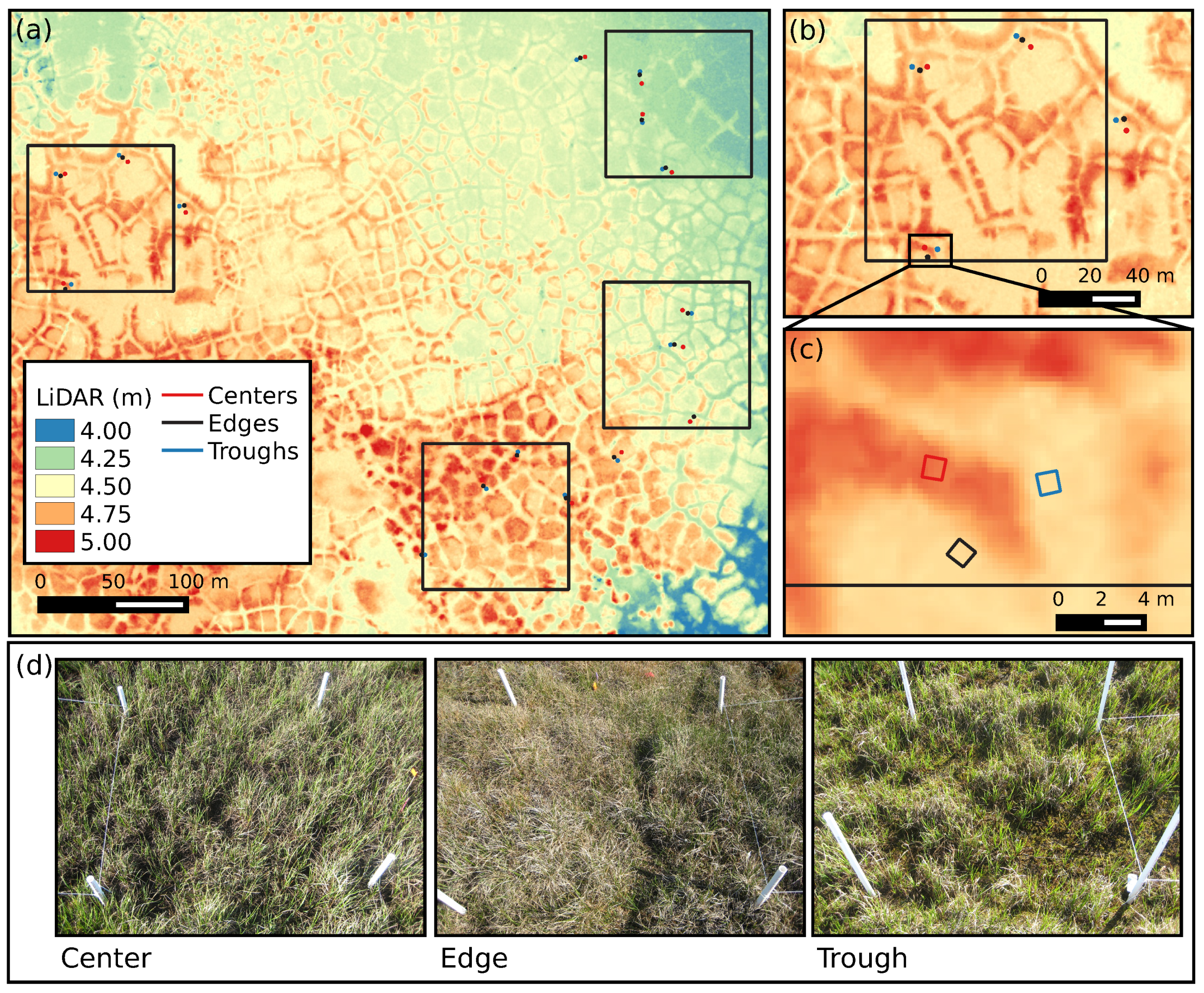
2.1.1. Study Area
2.1.2. Field Vegetation Surveys
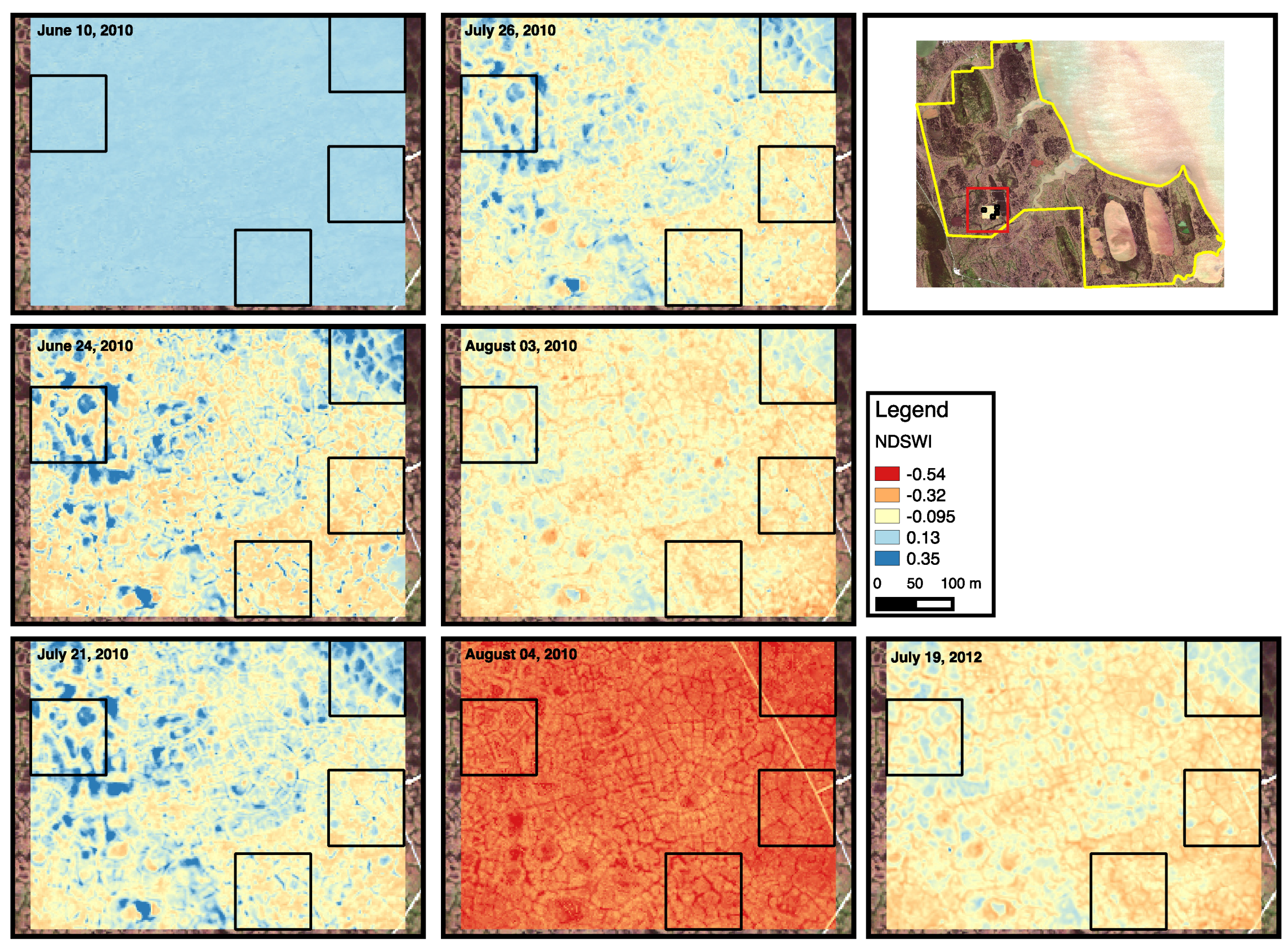
2.1.3. Remote Sensing Datasets
2.2. Characterizing the Heterogeneous Landscape
2.3. Quantifying the Representativeness of Field Vegetation Observations
2.4. Statistical Upscaling of PFT Distribution on the Landscape
2.5. Validation of PFT Upscaling
2.5.1. Bootstrap Validation
2.5.2. Ground-Truthing
3. Results
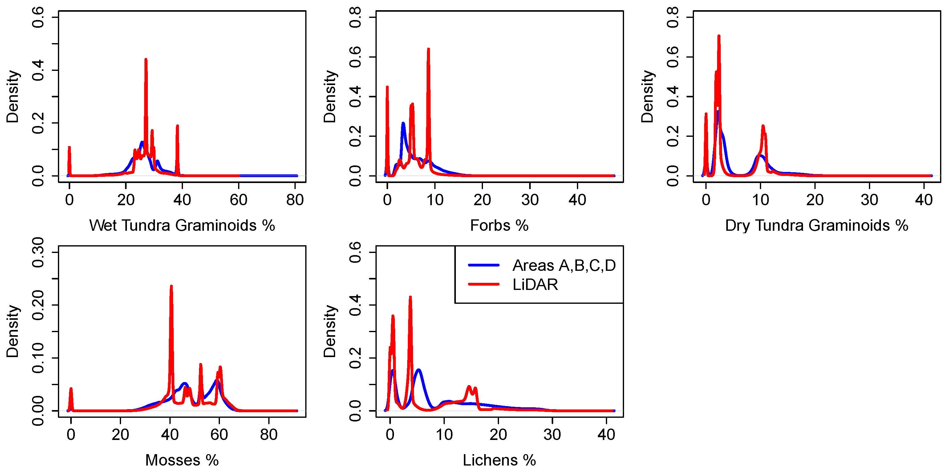
3.1. Analysis of Datasets
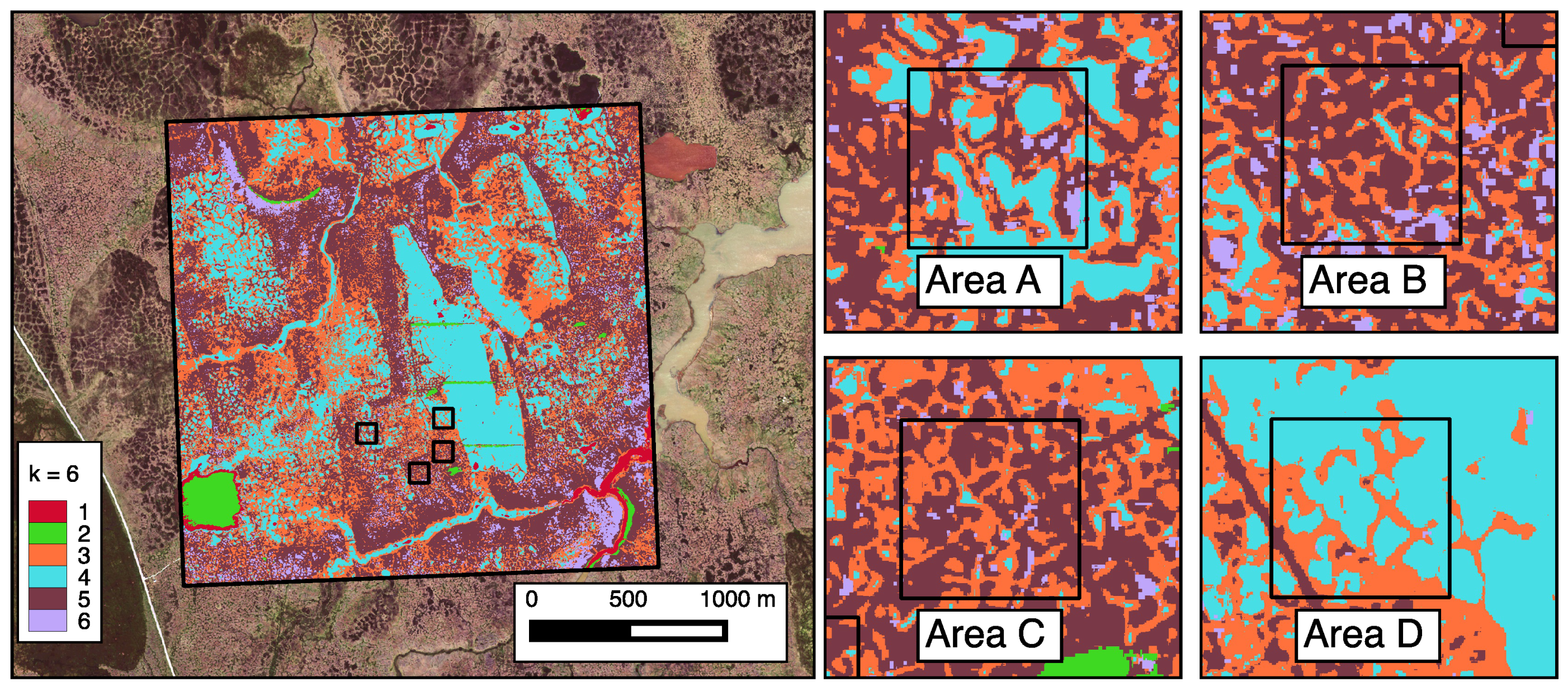
3.2. Landscape Characterization Using Unsupervised Clustering
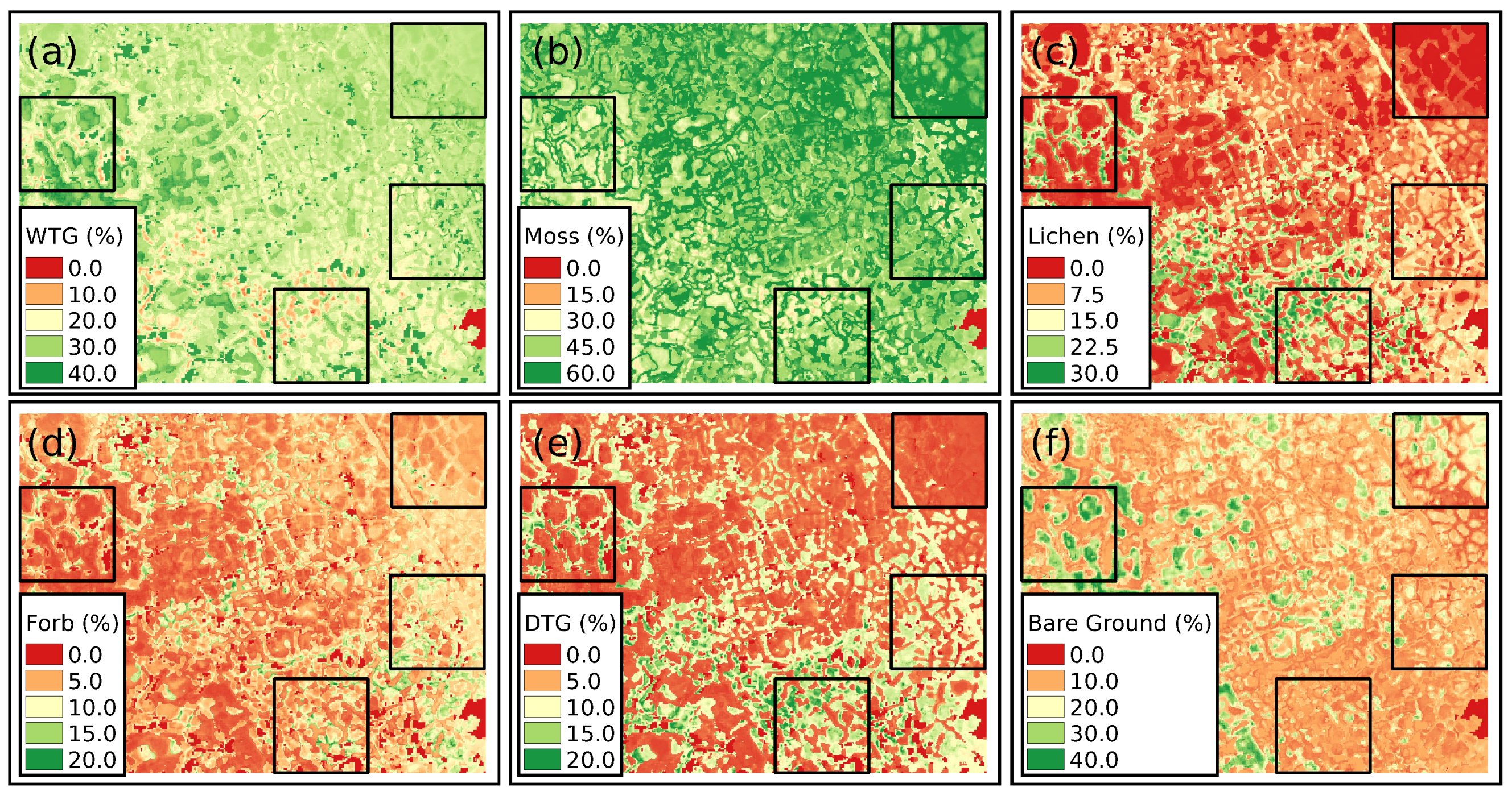
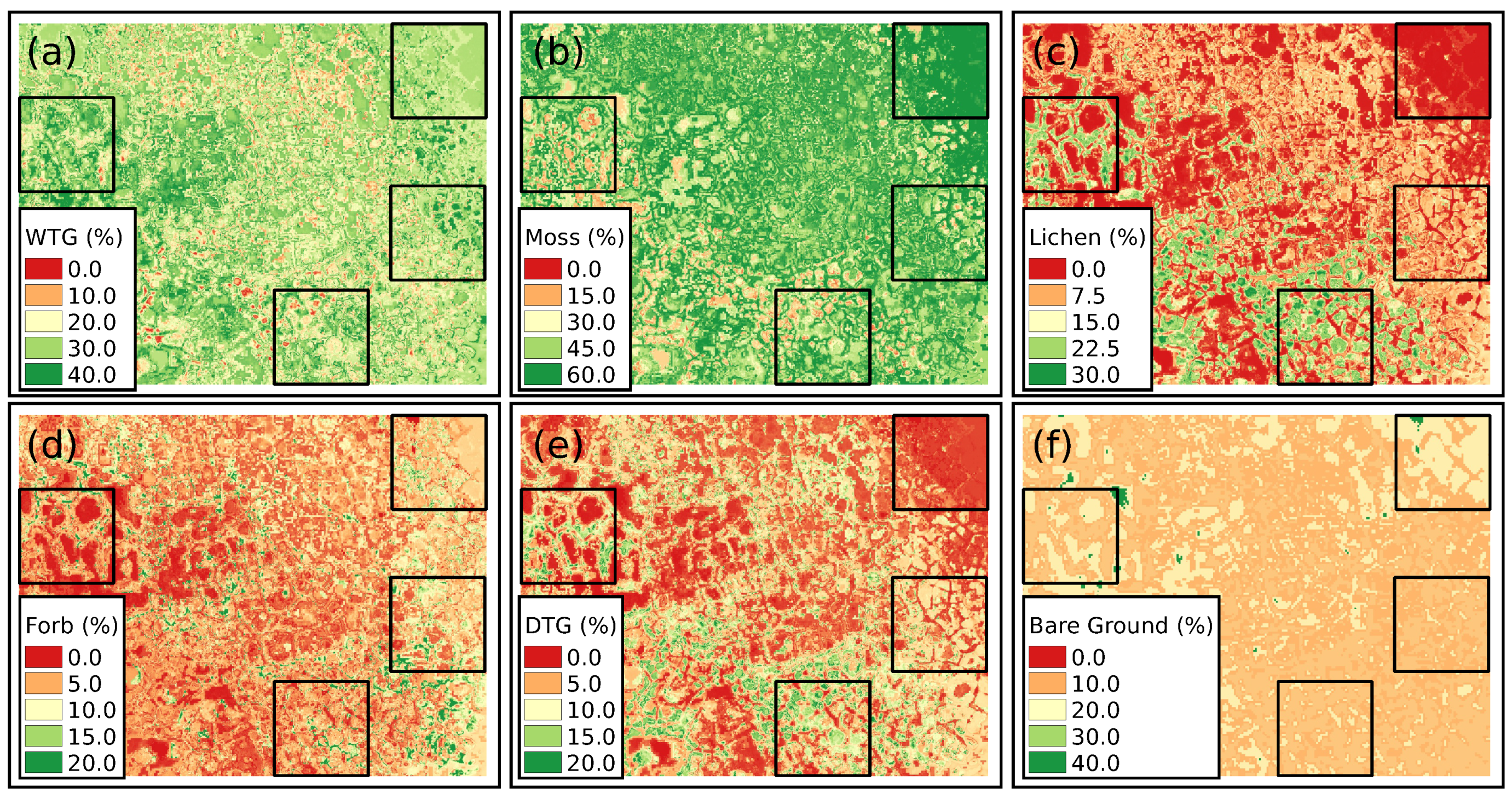
3.3. Upscaling of PFT Distributions
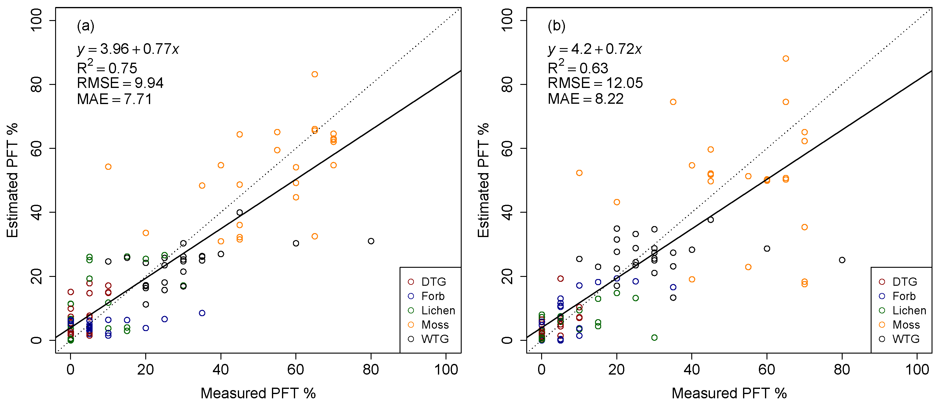
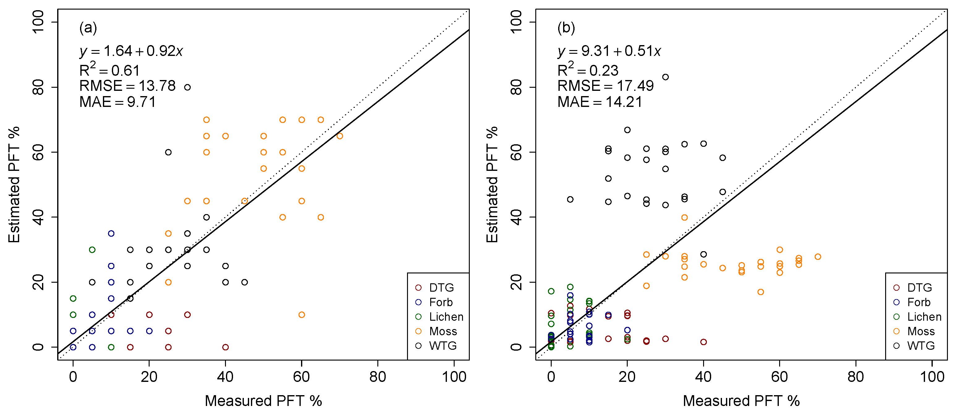
3.4. Validation of Upscaled PFT Distribution
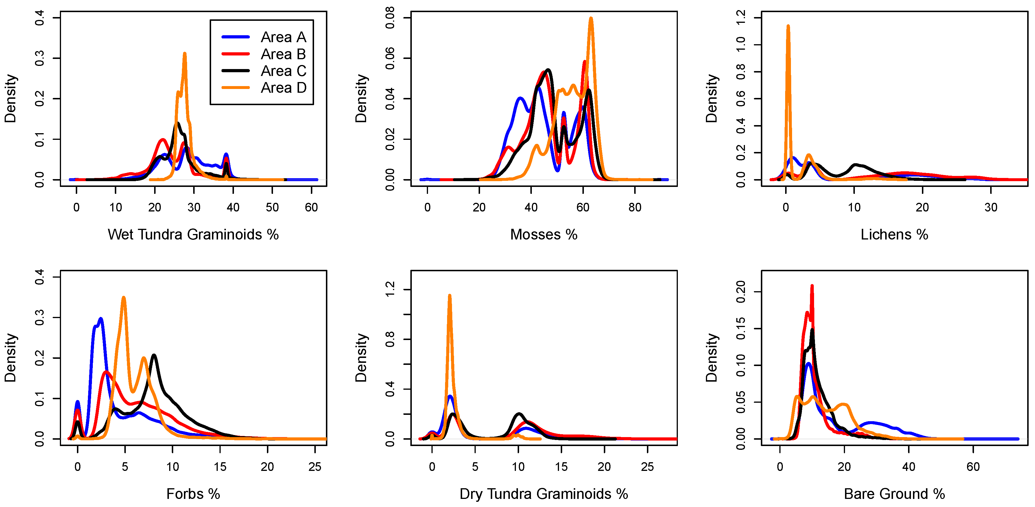
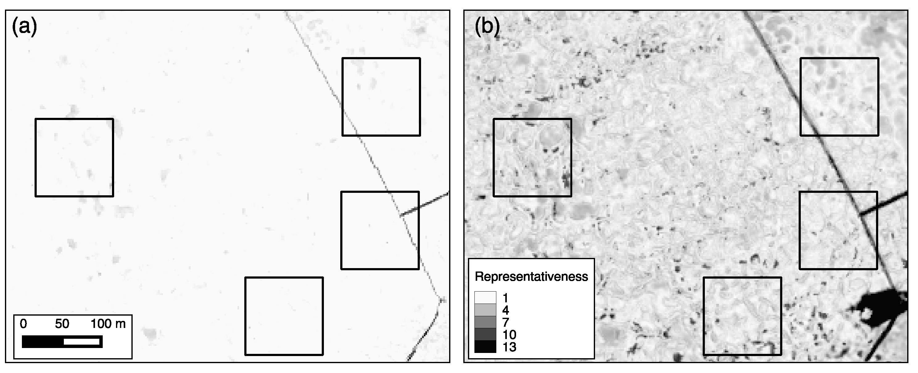
3.4.1. Representativeness
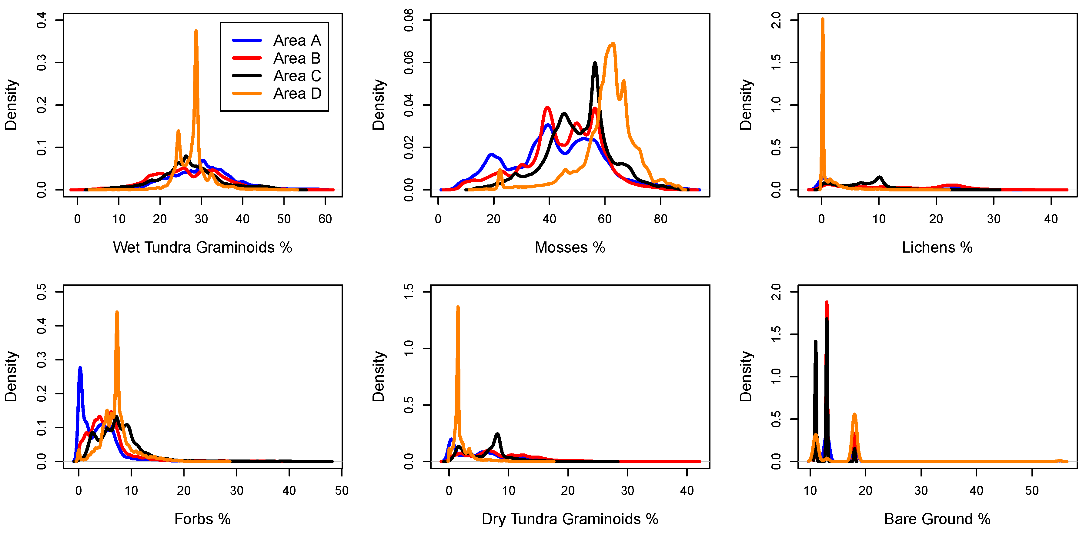
3.4.2. Ground-Truthing of the Upscaled PFT Distribution
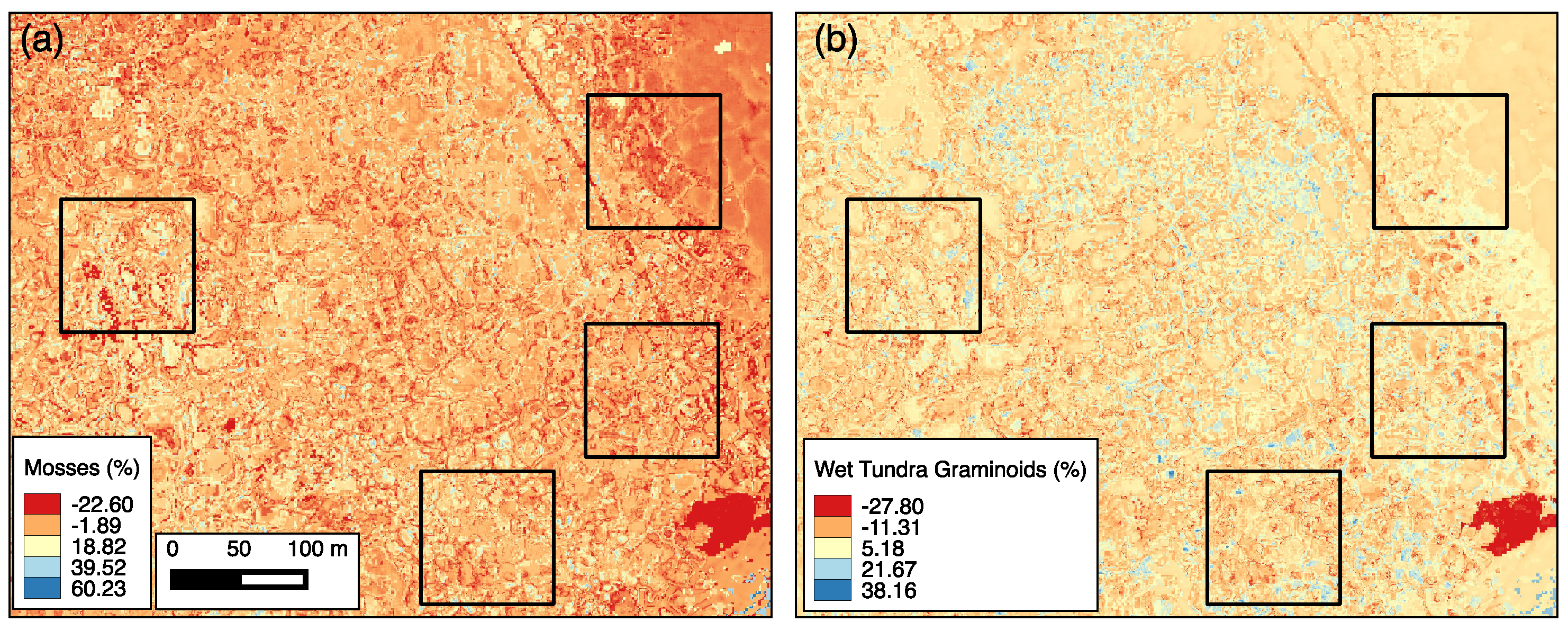
3.4.3. Improving Upscaling of PFTs Using Representativeness-Based Sampling
4. Discussion
5. Conclusions
Supplementary Materials
Acknowledgments
Author Contributions
Conflicts of Interest
Appendix
References
- Intergovernmental Panel on Climate Change (IPCC). Summary for policymakers. In Climate Change 2013: The Physical Science Basis; Contribution of Working Group I to the Fifth Assessment Report of the Intergovernmental Panel on Climate Change; Stocker, T., Qin, D., Plattner, G.K., Tignor, M., Allen, S., Boschung, J., Nauels, A., Xia, Y., Bex, V., Midgley, P., Eds.; Cambridge University Press: Cambridge, UK; New York, NY, USA, 2013. [Google Scholar]
- Anisimov, O.A.; Vaughan, D.G.; Callaghan, T.V.; Furgal, C.; Marchant, H.; Prowse, T.D.; Vilhjálmsson, H.; Walsh, J.E. Polar regions (Arctic and Antarctic). In Climate Change 2007: Impacts, Adaptation and Vulnerability; Parry, M.L., Canziani, O.F., Palutikof, J.P., van der Linden, P.J., Hanson, C.E., Eds.; Cambridge University Press: Cambridge, UK, 2007; pp. 653–685. [Google Scholar]
- Jorgenson, M.T.; Shur, Y.L.; Pullman, E.R. Abrupt increase in permafrost degradation in Arctic Alaska. Geophys. Res. Lett. 2006, 33, L02503. [Google Scholar] [CrossRef]
- Rowland, J.; Jones, C.; Altmann, G.; Bryan, R.; Crosby, B.; Hinzman, L.; Kane, D.; Lawrence, D.; Mancino, A.; Marsh, P.; et al. Arctic landscapes in transition: Responses to thawing permafrost. Eos Trans. AGU 2010, 91, 229–236. [Google Scholar] [CrossRef]
- Hinzman, L.; Deal, C.J.; McGuire, A.D.; Mernild, S.H.; Polyakov, I.V.; Walsh, J.E. Trajectory of the Arctic as an integrated system. Ecol. Appl. 2013, 23, 1837–1868. [Google Scholar] [CrossRef] [PubMed]
- Myers-Smith, I.H.; Forbes, B.C.; Wilmking, M.; Hallinger, M.; Lantz, T.; Blok, D.; Tape, K.D.; Macias-Fauria, M.; Sass-Klaassen, U.; Lèvesque, E.; et al. Shrub expansion in tundra ecosystems: Dynamics, impacts and research priorities. Environ. Res. Lett. 2011, 6, 045509. [Google Scholar] [CrossRef]
- Euskirchen, E.S.; Edgar, C.W.; Turetsky, M.R.; Waldrop, M.P.; Harden, J.W. Differential response of carbon fluxes to climate in three peatland ecosystems that vary in the presence and stability of permafrost. J. Geophys. Res. Biogeosci. 2014, 119, 1576–1595. [Google Scholar] [CrossRef]
- Wullschleger, S.D.; Epstein, H.E.; Box, E.O.; Euskirchen, E.S.; Goswami, S.; Iversen, C.M.; Kattge, J.; Norby, R.J.; van Bodegom, P.M.; Xu, X. Plant functional types in earth system models: Past experiences and future directions for application of dynamic vegetation models in high-latitude ecosystems. Ann. Bot. 2014, 114, 1–16. [Google Scholar] [CrossRef] [PubMed]
- Oleson, K.W.; Lawrence, D.M.; Bonan, G.B.; Drewniak, B.; Huang, M.; Koven, C.D.; Levis, S.; Li, F.; Riley, W.J.; Subin, Z.M.; et al. Technical Description of Version 4.5 of the Community Land Model (CLM); NCAR Technical Note NCAR/TN-503+STR; National Center for Atmospheric Research: Boulder, CO, USA, 2013. [Google Scholar]
- Smith, T.M.; Shugart, H.H.; Woodward, F.I. Plant Functional Types: Their Relevance to Ecosystem Properties and Global Change; Cambridge University Press: Cambridge, UK, 1997; p. 388. [Google Scholar]
- Sun, W.; Liang, S.; Xu, G.; Fang, H.; Dickinson, R. Mapping plant functional types from MODIS data using multi-source evidential reasoning. Remote Sens. Environ. 2008, 112, 1010–1024. [Google Scholar] [CrossRef]
- Chapin, F.S.; McGuire, A.D.; Ruess, R.W.; Hollingsworth, T.N.; Mack, M.C.; Johnstone, J.F.; Kasischke, E.S.; Euskirchen, E.S.; Jones, J.B.; Jorgenson, M.T.; et al. Resilience of Alaska’s boreal forest to climatic change. Can. J. For. Res. 2010, 40, 1360–1370. [Google Scholar] [CrossRef]
- Chapin, F.S.; Bret-Harte, M.S.; Hobbie, S.E.; Zhong, H. Plant functional types as predictors of transient responses of Arctic vegetation to global change. J. Veg. Sci. 1996, 7, 347–358. [Google Scholar] [CrossRef]
- Poulter, B.; Ciais, P.; Hodson, E.; Lischke, H.; Maignan, F.; Plummer, S.; Zimmermann, N.E. Plant functional type mapping for Earth system models. Geosci. Model Dev. 2011, 4, 993–1010. [Google Scholar] [CrossRef]
- Huemmrich, K.; Gamon, J.; Tweedie, C.; Campbell, P.; Landis, D.; Middleton, M. Arctic tundra vegetation functional types based on photosynthetic physiology and optical properties. IEEE J. Sel. Top. Appl. Earth Observ. Remote Sens. 2013, 6, 265–275. [Google Scholar] [CrossRef]
- Ustin, S.L.; Gamon, J.A. Remote sensing of plant functional types. New Phytol. 2010, 186, 795–816. [Google Scholar] [CrossRef] [PubMed]
- Atchley, A.L.; Painter, S.L.; Harp, D.R.; Coon, E.T.; Wilson, C.J.; Liljedahl, A.K.; Romanovsky, V.E. Using field observations to inform thermal hydrology models of permafrost dynamics with ATS (v0.83). Geosci. Model Dev. 2015, 8, 2701–2722. [Google Scholar] [CrossRef]
- Kumar, J.; Collier, N.; Bisht, G.; Mills, R.T.; Thornton, P.E.; Iversen, C.M.; Romanovsky, V. Modeling the spatio-temporal variability in subsurface thermal regimes across a low-relief polygonal tundra landscape. Cryosphere Discuss. 2016, 1–32. [Google Scholar] [CrossRef]
- Tang, G.; Yuan, F.; Bisht, G.; Hammond, G.E.; Lichtner, P.C.; Kumar, J.; Mills, R.T.; Xu, X.; Andre, B.; Hoffman, F.M.; et al. Addressing numerical challenges in introducing a reactive transport code into a land surface model: A biogeochemical modeling proof-of-concept with CLM–PFLOTRAN 1.0. Geosci. Model Dev. 2016, 9, 927–946. [Google Scholar] [CrossRef]
- Stow, D.A.; Hope, A.; McGuire, D.; Verbyla, D.; Gamon, J.; Huemmrich, F.; Houston, S.; Racine, C.; Sturm, M.; Tape, K.; et al. Remote sensing of vegetation and land-cover change in Arctic Tundra Ecosystems. Remote Sens. Environ. 2004, 89, 281–308. [Google Scholar] [CrossRef]
- Selkowitz, D.J. A comparison of multi-spectral, multi-angular, and multi-temporal remote sensing datasets for fractional shrub canopy mapping in Arctic Alaska. Remote Sens. Environ. 2010, 114, 1338–1352. [Google Scholar] [CrossRef]
- Atkinson, D.M.; Treitz, P. Arctic ecological classifications derived from vegetation community and satellite spectral data. Remote Sens. 2012, 4, 3948. [Google Scholar] [CrossRef]
- Dalmayne, J.; Möckel, T.; Prentice, H.; Schmid, B.; Hall, K. Assessment of fine-scale plant species beta diversity using WorldView-2 satellite spectral dissimilarity. Ecol. Inform. 2013, 18, 1–9. [Google Scholar] [CrossRef]
- Ramoelo, A.; Cho, M.; Mathieu, R.; Madonsela, S.; van de Kerchove, R.; Kaszta, Z.; Wolff, E. Monitoring grass nutrients and biomass as indicators of rangeland quality and quantity using random forest modelling and WorldView-2 data. Int. J. Appl. Earth Observ. Geoinform. 2015, 43, 43–54. [Google Scholar] [CrossRef]
- Karna, Y.K.; Hussin, Y.A.; Gilani, H.; Bronsveld, M.; Murthy, M.; Qamer, F.M.; Karky, B.S.; Bhattarai, T.; Aigong, X.; Baniya, C.B. Integration of WorldView-2 and airborne LiDAR data for tree species level carbon stock mapping in Kayar Khola watershed, Nepal. Int. J. Appl. Earth Observ. Geoinform. 2015, 38, 280–291. [Google Scholar] [CrossRef]
- Mutanga, O.; Adam, E.; Cho, M.A. High density biomass estimation for wetland vegetation using WorldView-2 imagery and random forest regression algorithm. Int. J. Appl. Earth Observ. Geoinform. 2012, 18, 399–406. [Google Scholar] [CrossRef]
- Gangodagamage, C.; Rowland, J.C.; Hubbard, S.S.; Brumby, S.P.; Liljedahl, A.K.; Wainwright, H.; Wilson, C.J.; Altmann, G.L.; Dafflon, B.; Peterson, J.; et al. Extrapolating active layer thickness measurements across Arctic polygonal terrain using LiDAR and NDVI datasets. Water Resour. Res. 2014, 50, 6339–6357. [Google Scholar] [CrossRef] [PubMed]
- Richardson, A.D.; Keenan, T.F.; Migliavacca, M.; Ryu, Y.; Sonnentag, O.; Toomey, M. Climate change, phenology, and phenological control of vegetation feedbacks to the climate system. Agric. For. Meteorol. 2013, 169, 156–173. [Google Scholar] [CrossRef]
- Mills, R.T.; Kumar, J.; Hoffman, F.M.; Hargrove, W.W.; Spruce, J.P.; Norman, S.P. Identification and visualization of dominant patterns and anomalies in remotely sensed vegetation phenology using a parallel tool for principal components analysis. Procedia Comput. Sci. 2013, 18, 2396–2405. [Google Scholar] [CrossRef]
- Walker, J.; de Beurs, K.; Henebry, G. Land surface phenology along urban to rural gradients in the U.S. Great Plains. Remote Sens. Environ. 2015, 165, 42–52. [Google Scholar] [CrossRef]
- Hoffman, F.M.; Kumar, J.; Mills, R.T.; Hargrove, W.W. Representativeness-based Sampling Network Design for the State of Alaska. Landsc. Ecol. 2013, 28, 1567–1586. [Google Scholar] [CrossRef]
- Liljedahl, A.K.; Hinzman, L.D.; Harazono, Y.; Zona, D.; Tweedie, C.E.; Hollister, R.D.; Engstrom, R.; Oechel, W.C. Nonlinear controls on evapotranspiration in Arctic coastal wetlands. Biogeosciences 2011, 8, 3375–3389. [Google Scholar] [CrossRef]
- Bockheim, J.G.; Everett, L.R.; Hinkel, K.M.; Nelson, F.E.; Brown, J. Soil organic carbon storage and distribution in arctic Tundra, Barrow, Alaska. Soil Sci. Soc. Am. J. 1999, 63, 934–940. [Google Scholar] [CrossRef]
- Hubbard, S.; Gangodagamage, C.; Dafflon, B.; Wainwright, H.; Peterson, J.; Gusmeroli, A.; Ulrich, C.; Wu, Y.; Wilson, C.; Rowland, J.; et al. Quantifying and relating land-surface and subsurface variability in permafrost environments using LiDAR and surface geophysical datasets. Hydrogeol. J. 2013, 21, 149–169. [Google Scholar] [CrossRef]
- Brown, J. Tundra soils formed over ice wedges, Northern Alaska. Soil Sci. Soc. Am. J. 1967, 31, 686–691. [Google Scholar] [CrossRef]
- Washburn, A.L. Geocryology: A Survey of Periglacial Processes and Environments; The Blackburn Press: Caldwell, NJ, USA, 1978; p. 416. [Google Scholar]
- Updike, T.; Comp, C. Radiometric Use of WorldView-2 Imagery; Technical Note; DigitalGlobe, Inc.: Longmont, CO, USA, 2010. [Google Scholar]
- Rouse, J.; Haas, R.; Schell, J.; Deering, D. Monitoring vegetation systems in the Great Plains with ERTS-1. In Proceedings of the 3rd Earth Resources Technology Satellite Symposium, Washington, DC, USA, 10–14 December 1973; NASA: Washington, DC, USA, 1974; pp. 309–317. [Google Scholar]
- Hartigan, J.A. Clustering Algorithms; John Wiley & Sons, Inc.: New York, NY, USA, 1975; p. 351. [Google Scholar]
- Hoffman, F.M.; Hargrove, W.W.; Mills, R.T.; Mahajan, S.; Erickson, D.J.; Oglesby, R.J. Multivariate Spatio-Temporal Clustering (MSTC) as a data mining tool for environmental applications. In Proceedings of the iEMSs Fourth Biennial Meeting: International Congress on Environmental Modelling and Software Society (iEMSs 2008), Barcelona, Spain, 7–10 July 2008; pp. 1774–1781.
- Bradley, P.S.; Fayyad, U.M. Refining initial points for k-means clustering. In Proceedings of the Fifteenth International Conference on Machine Learning (ICML 1998), Anaheim, CA, USA, 18–20 December 1998; Morgan Kaufmann Publishers Inc.: San Francisco, CA, USA, 1998; pp. 91–99. [Google Scholar]
- Kumar, J.; Mills, R.T.; Hoffman, F.M.; Hargrove, W.W. Parallel k-Means clustering for quantitative ecoregion delineation using large datasets. In Procedia Computer Science, Proceedings of the International Conference on Computational Science (ICCS 2011), Singapore, 1–3 June 2010; Sato, M., Matsuoka, S., Sloot, P.M., van Albada, G.D., Dongarra, J., Eds.; Elsevier: Amsterdam, The Netherlands, 2011; Volume 4, pp. 1602–1611. [Google Scholar]
- Hargrove, W.W.; Hoffman, F.M.; Law, B.E. New analysis reveals representativeness of the AmeriFlux Network. Eos Trans. AGU 2003, 84, 529–535. [Google Scholar] [CrossRef]
- Ringaby, E.; Friman, O.; Forssén, P.E.; Opsahl, T.; Haavardsholm, T.V.; Kåsen, I. Anisotropic scattered data interpolation for pushbroom image rectification. IEEE Trans. Image Process. 2014, 23, 2302–2314. [Google Scholar] [CrossRef] [PubMed]
- Dennis, J.G.; Tieszen, L.L.; Vetter, M.A. Seasonal dynamics of above- and below-ground production of vascular plants at Barrow, Alaska. In Vegetation and Production Ecology of an Alaskan Arctic Tundra; Springer: New York, NY, USA, 1978; Volume 29, pp. 113–140. [Google Scholar]
- Huemmrich, K.; Gamon, J.; Tweedie, C.; Oberbauer, S.; Kinoshita, G.; Houston, S.; Kuchy, A.; Hollister, R.; Kwon, H.; Mano, M.; et al. Remote sensing of tundra gross ecosystem productivity and light use efficiency under varying temperature and moisture conditions. Remote Sens. Environ. 2010, 114, 481–489. [Google Scholar] [CrossRef]
- Sloan, V.; Brooks, J.; Wood, S.; Liebig, J.; Siegrist, J.; Iversen, C.; Norby, R. Plant Community Composition and Vegetation Height, Barrow, Alaska, Ver. 1; Next Generation Ecosystem Experiments Arctic Data Collection; Carbon Dioxide Information Analysis Center; Oak Ridge National Laboratory: Oak Ridge, TN, USA, 2014; Available online: http://dx.doi.org/10.5440/1129476 (accessed on 16 July 2016).
- Iversen, C.M.; Sloan, V.L.; Sullivan, P.F.; Euskirchen, E.S.; McGuire, A.D.; Norby, R.J.; Walker, A.P.; Warren, J.M.; Wullschleger, S.D. The unseen iceberg: Plant roots in arctic tundra. New Phytol. 2015, 205, 34–58. [Google Scholar] [CrossRef] [PubMed]
- Villarreal, S.; Hollister, R.D.; Johnson, D.R.; Lara, M.J.; Webber, P.J.; Tweedie, C.E. Tundra vegetation change near Barrow, Alaska (1972–2010). Environ. Res. Lett. 2012, 7, 015508. [Google Scholar] [CrossRef]
- Goswami, S.; Gamon, J.A.; Tweedie, C.E. Surface hydrology of an arctic ecosystem: Multiscale analysis of a flooding and draining experiment using spectral reflectance. J. Geophys. Res. Biogeosci. 2011, 116, G00I07. [Google Scholar] [CrossRef]
- Langford, Z.; Kumar, J.; Hoffman, F. Remote sensing-based characterization, 2-m, Plant Functional Type Distributions, Barrow Environmental Observatory, 2010; Next Generation Ecosystem Experiments Arctic Data Collection; Carbon Dioxide Information Analysis Center; Oak Ridge National Laboratory: Oak Ridge, TN, USA, 2015; Available online: http://dx.doi.org/10.5440/1123668 (accessed on 16 July 2012).


| Area | Characteristics | Relative Elevation | Moisture Conditions |
|---|---|---|---|
| A | Low center polygons (with edges and troughs) | Low | Inundated |
| B | High center polygons | High | Desiccated |
| C | Transitional low center polygons (with edges and troughs) | Moderate | Moderately Dry |
| D | Low center polygons (few edges and troughs) | Low | Inundated |
| Number of Variables | ||
|---|---|---|
| Variables | (Without Phenology, With Phenology) | Platform |
| Elevation | 1, 1 | LiDAR |
| TOA Red Band | 1, 6 | WorldView-2 |
| TOA Blue Band | 1, 6 | WorldView-2 |
| TOA Green Band | 1, 6 | WorldView-2 |
| TOA NIR Band | 1, 6 | WorldView-2 |
| NDVI | 1, 6 | WorldView-2 |
| k | Cluster Number | |||||||||
|---|---|---|---|---|---|---|---|---|---|---|
| 1 | 2 | 3 | 4 | 5 | 6 | 7 | 8 | 9 | 10 | |
| 3 | 116 | 1 | 75 | – | – | – | – | – | – | – |
| 4 | 115 | 1 | 76 | 0 | – | – | – | – | – | – |
| 5 | 79 | 68 | 44 | 0 | 1 | – | – | – | – | – |
| 6 | 0 | 0 | 63 | 49 | 79 | 1 | – | – | – | – |
| 7 | 54 | 50 | 1 | 65 | 0 | 22 | 0 | – | – | – |
| 8 | 0 | 22 | 0 | 54 | 1 | 65 | 50 | 0 | – | – |
| 9 | 0 | 55 | 51 | 45 | 4 | 18 | 19 | 0 | 0 | – |
| 10 | 33 | 26 | 0 | 1 | 50 | 0 | 0 | 10 | 54 | 18 |
| PFT% | Without Phenology | With Phenology | ||||
|---|---|---|---|---|---|---|
| R2 | Adjusted R2 | AIC | R2 | Adjusted R2 | AIC | |
| Wet Tundra Graminoid | 0.13 | 0.10 | 1575.00 | 0.58 | 0.50 | 1483.80 |
| Dry Tundra Graminoid | 0.34 | 0.32 | 1305.38 | 0.59 | 0.51 | 1263.48 |
| Forb | 0.26 | 0.23 | 1401.60 | 0.48 | 0.39 | 1380.26 |
| Moss | 0.26 | 0.24 | 1754.93 | 0.53 | 0.44 | 1717.31 |
| Lichen | 0.54 | 0.53 | 1393.88 | 0.75 | 0.70 | 1329.56 |
| Bare Ground | 0.37 | 0.35 | 1619.66 | 0.63 | 0.57 | 1563.31 |
| PFT | |||
|---|---|---|---|
| Wet Tundra Graminoids | |||
| Area A | 33.8, 12.1 | 45.2, 12.0 | 35.0, 7.8 |
| Area B | 2.6, 2.3 | 16.1, 11.0 | 24.2, 7.1 |
| Area C | 35.8, 21.0 | 10.7, 10.0 | 21.0, 12.1 |
| Area D | 25.5, 3.7 | 23.9, 7.9 | 35.8, 13.6 |
| Dry Tundra Graminoids | |||
| Area A | 0.0, 0.0 | 6.0, 4.4 | 0.0, 0.0 |
| Area B | 23.3, 12.3 | 9.3, 5.1 | 2.1, 3.8 |
| Area C | 10.5, 12.6 | 13.7, 6.3 | 1.4, 1.2 |
| Area D | 2.5, 5.0 | 2.7, 1.9 | 0.2, 0.2 |
| Forbs | |||
| Area A | 0.0, 0.0 | 3.3, 3.2 | 1.3, 2.6 |
| Area B | 1.5, 2.8 | 5.3, 5.8 | 11.0, 21.2 |
| Area C | 4.0, 2.7 | 9.0, 6.0 | 17.6, 22.1 |
| Area D | 2.3, 2.6 | 16.8, 11.0 | 1.3, 1.4 |
| Mosses | |||
| Area A | 10.2, 5.3 | 48.1, 16.1 | 73.3, 18.6 |
| Area B | 19.0, 15.7 | 45.6, 7.1 | 53.3, 29.7 |
| Area C | 27.1, 22.0 | 61.3, 16.9 | 72.8, 20.8 |
| Area D | 41.0, 27.0 | 66.1, 14.1 | 73.2, 10.4 |
| Lichens | |||
| Area A | 0.0, 0.0 | 16.4, 9.4 | 0.1, 0.1 |
| Area B | 37.3, 4.2 | 28.5, 7.2 | 1.2, 2.5 |
| Area C | 3.3, 1.8 | 16.3, 9.4 | 0.0, 0.0 |
| Area D | 0.1, 0.1 | 3.4, 4.6 | 0.0, 0.0 |
| Bare Ground | |||
| Area A | 57.2, 10.0 | 5.3, 10.6 | 10.0, 14.1 |
| Area B | 14.3, 13.2 | 6.5, 5.7 | 15.3, 25.1 |
| Area C | 25.6, 15.3 | 8.1, 9.6 | 3.1, 6.2 |
| Area D | 30.6, 29.9 | 3.4, 3.7 | 1.5, 3.1 |
© 2016 by the authors; licensee MDPI, Basel, Switzerland. This article is an open access article distributed under the terms and conditions of the Creative Commons Attribution (CC-BY) license (http://creativecommons.org/licenses/by/4.0/).
Share and Cite
Langford, Z.; Kumar, J.; Hoffman, F.M.; Norby, R.J.; Wullschleger, S.D.; Sloan, V.L.; Iversen, C.M. Mapping Arctic Plant Functional Type Distributions in the Barrow Environmental Observatory Using WorldView-2 and LiDAR Datasets. Remote Sens. 2016, 8, 733. https://doi.org/10.3390/rs8090733
Langford Z, Kumar J, Hoffman FM, Norby RJ, Wullschleger SD, Sloan VL, Iversen CM. Mapping Arctic Plant Functional Type Distributions in the Barrow Environmental Observatory Using WorldView-2 and LiDAR Datasets. Remote Sensing. 2016; 8(9):733. https://doi.org/10.3390/rs8090733
Chicago/Turabian StyleLangford, Zachary, Jitendra Kumar, Forrest M. Hoffman, Richard J. Norby, Stan D. Wullschleger, Victoria L. Sloan, and Colleen M. Iversen. 2016. "Mapping Arctic Plant Functional Type Distributions in the Barrow Environmental Observatory Using WorldView-2 and LiDAR Datasets" Remote Sensing 8, no. 9: 733. https://doi.org/10.3390/rs8090733
APA StyleLangford, Z., Kumar, J., Hoffman, F. M., Norby, R. J., Wullschleger, S. D., Sloan, V. L., & Iversen, C. M. (2016). Mapping Arctic Plant Functional Type Distributions in the Barrow Environmental Observatory Using WorldView-2 and LiDAR Datasets. Remote Sensing, 8(9), 733. https://doi.org/10.3390/rs8090733