Prediction of Topsoil Organic Carbon Using Airborne and Satellite Hyperspectral Imagery


 ,
, 

Abstract
:
1. Introduction
2. Materials and Methods
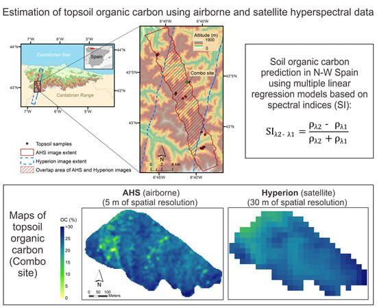
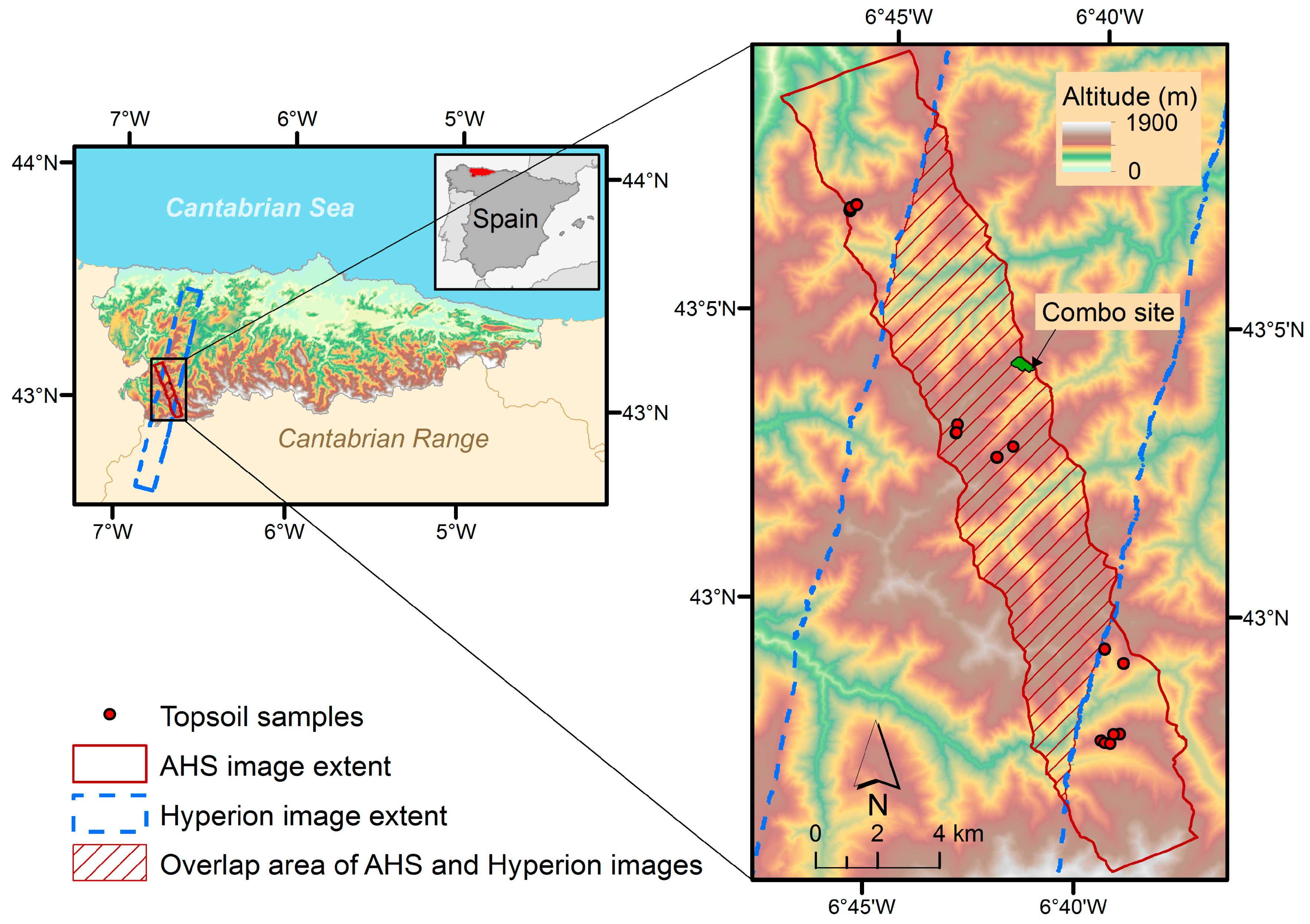
2.1. Study Area
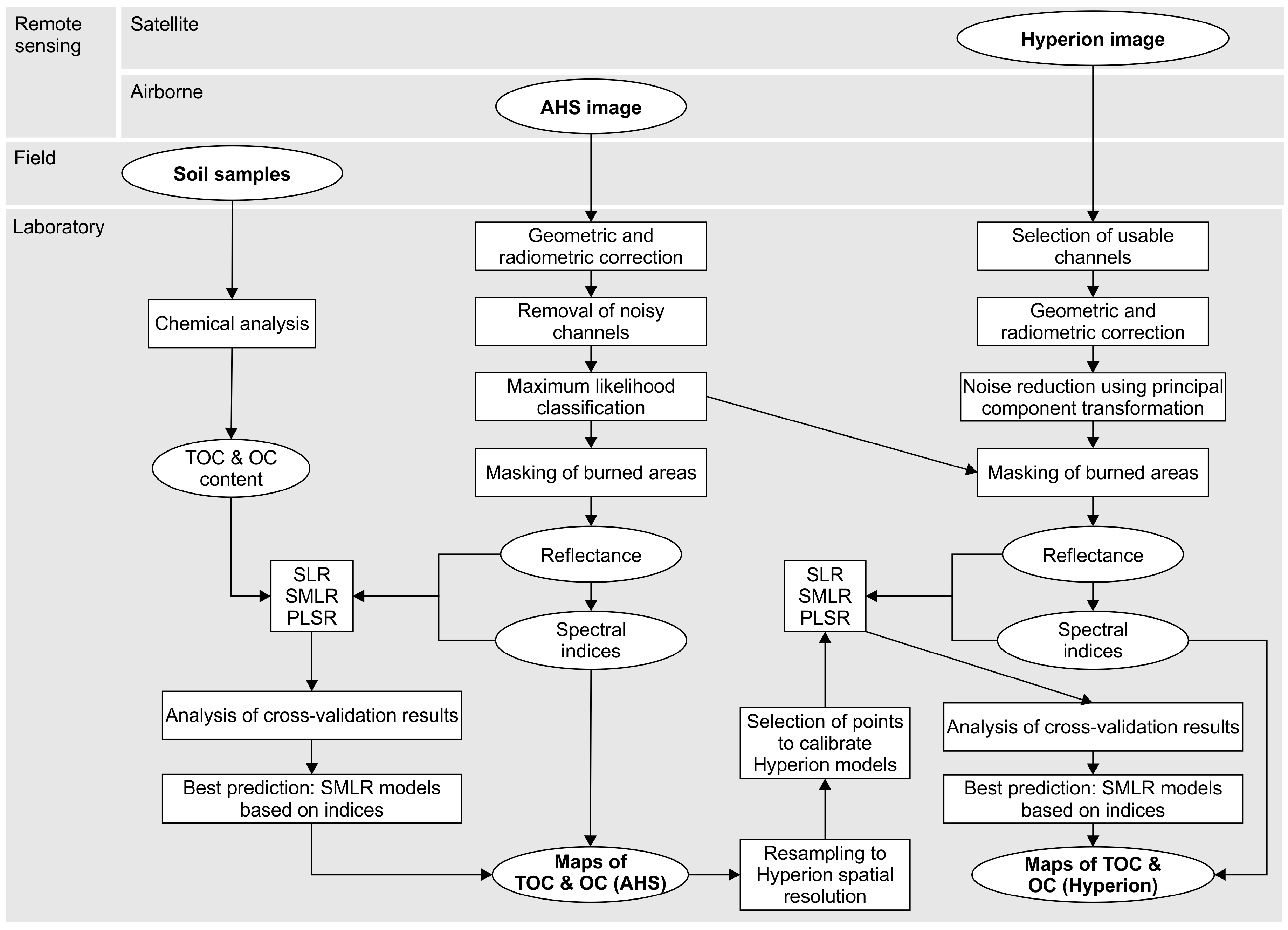
2.2. Airborne Hyperspectral Data
2.3. Satellite Hyperspectral Data
2.4. Field Data
2.5. Spectral Indices
2.6. SOC Modelling Using Airborne Hyperspectral Data
2.7. SOC Modelling Using Satellite Hyperspectral Data
3. Results
3.1. Descriptive Statistics of SOC
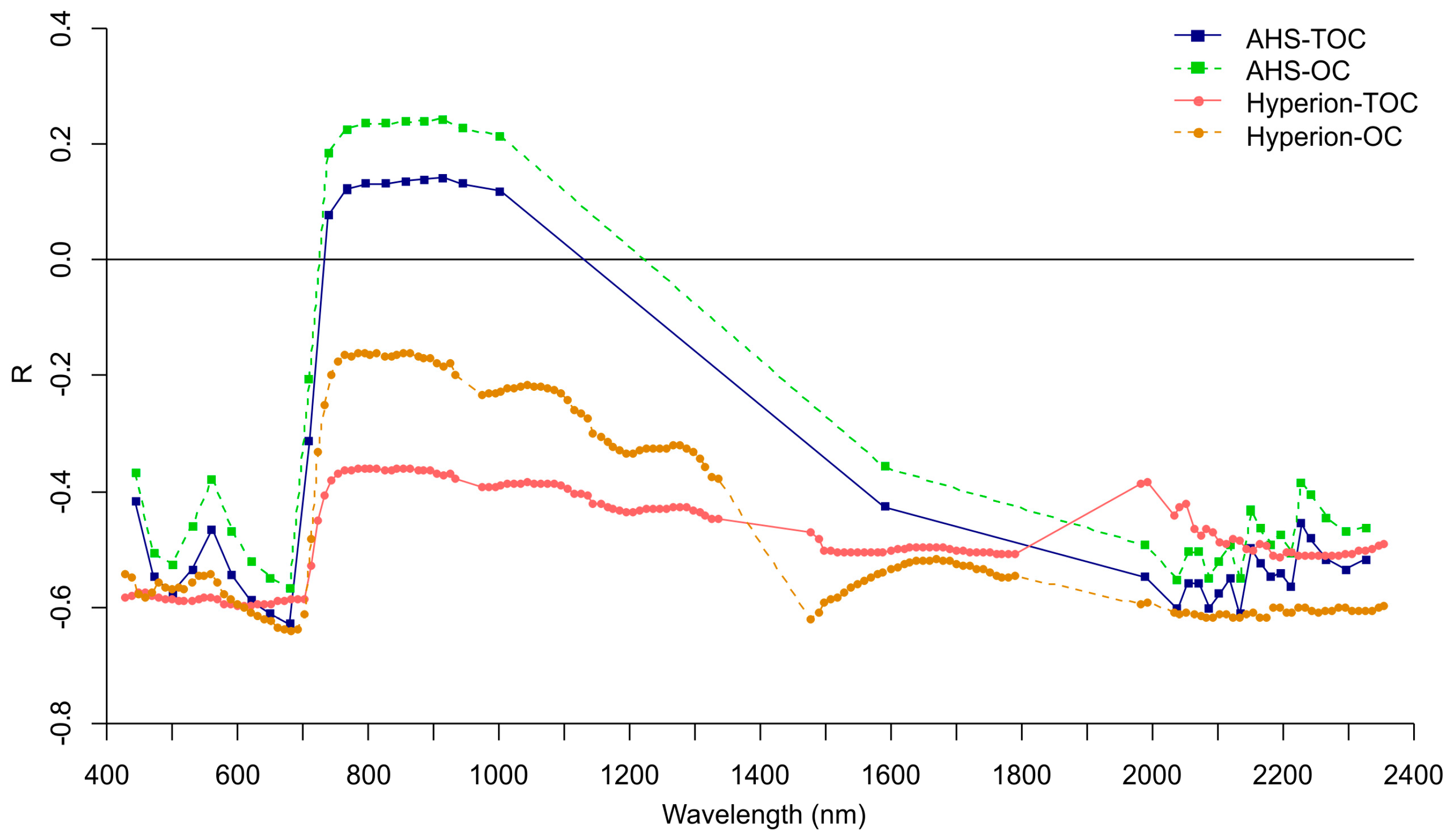
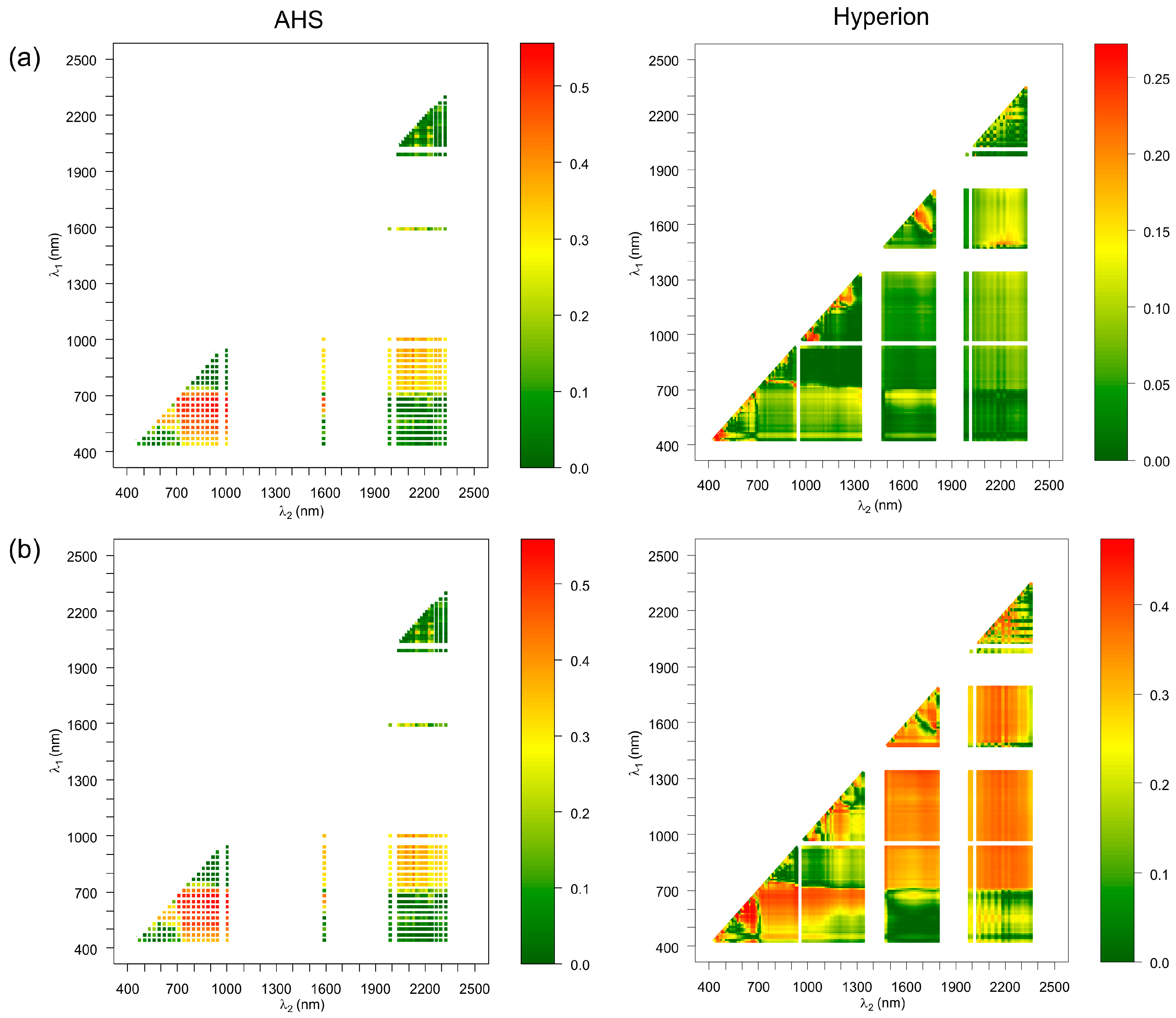
3.2. Correlation between SOC and Reflectances/Spectral Indices
3.3. SOC Predictive Models
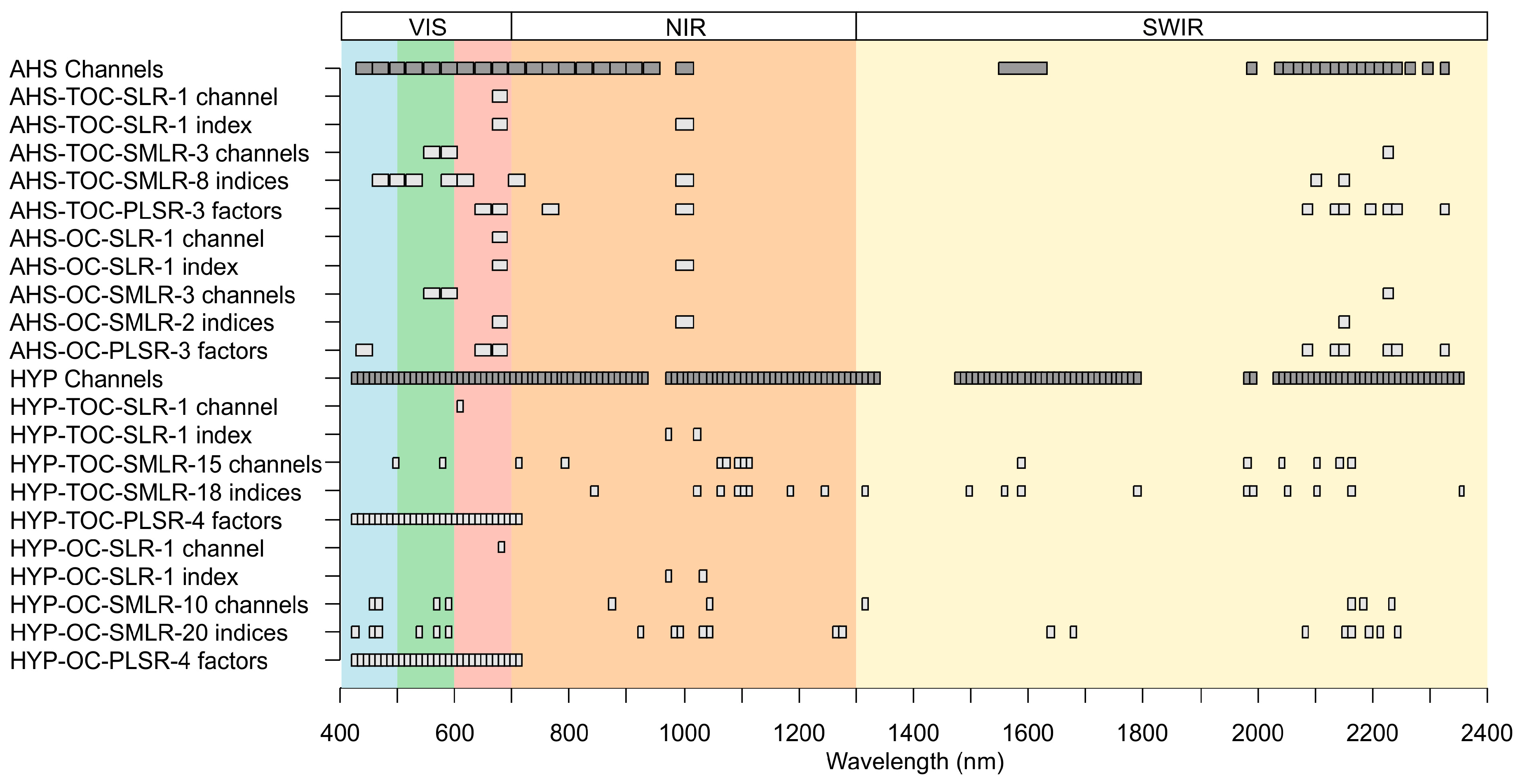
3.4. Relevant Wavelengths for SOC Prediction
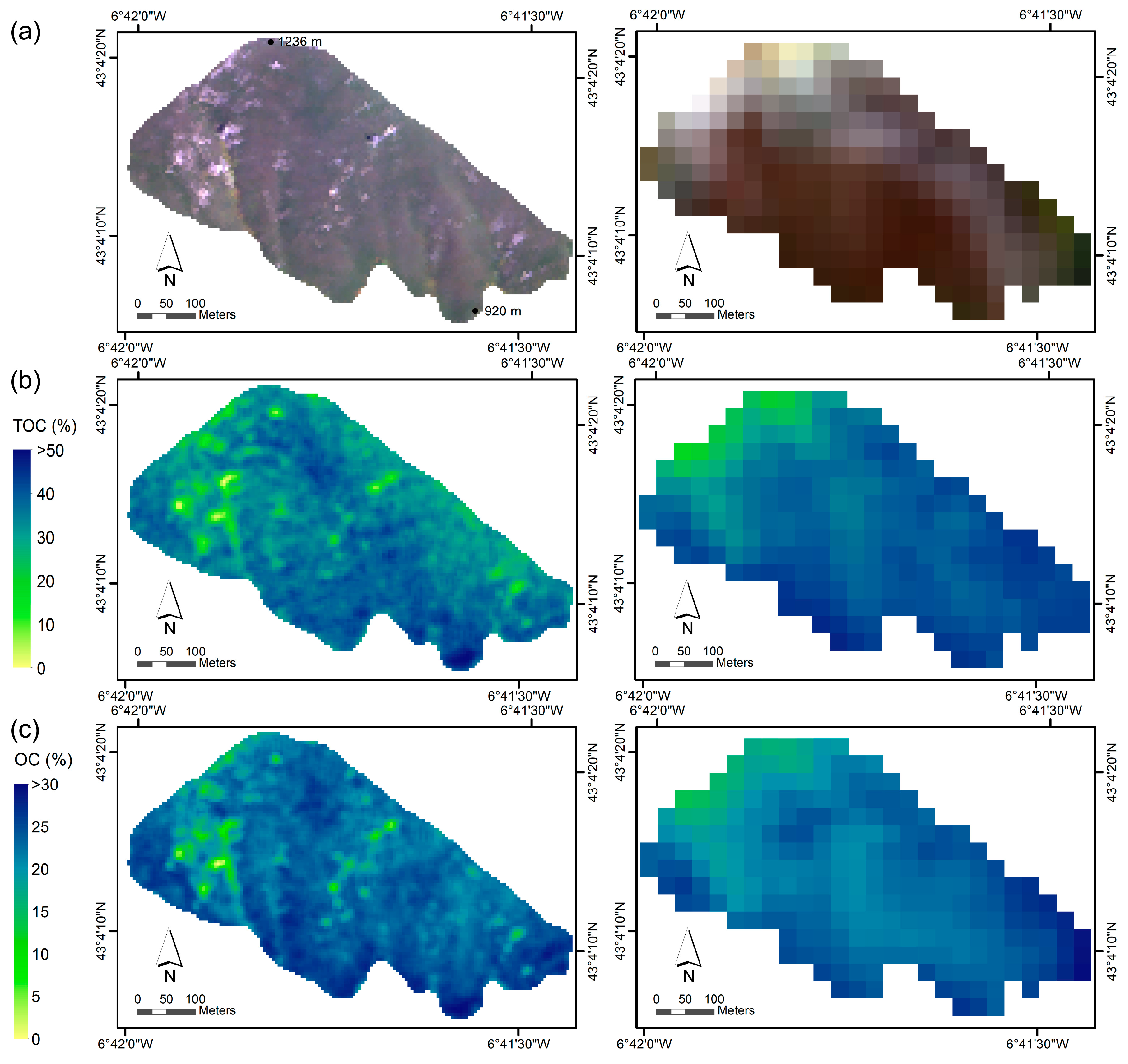
3.5. SOC Mapping
4. Discussion
5. Conclusions
Acknowledgments
Author Contributions
Conflicts of Interest
References
- Lal, R. Soil carbon sequestration impacts on global climate change and food security. Science 2004, 304, 1623–1627. [Google Scholar] [CrossRef] [PubMed]
- Houghton, R.A. Balancing the global carbon budget. Annu. Rev. Earth Planet. Sci. 2007, 35, 313–347. [Google Scholar] [CrossRef]
- Smith, P.; Gottschalk, P.; Smith, J. Climate change and soil carbon impacts. In Soil Carbon: Science, Management and Policy for Multiple Benefits; Banwart, S.A., Noellemeyer, E., Milne, E., Eds.; CABI: London, UK, 2014; pp. 235–242. [Google Scholar]
- Lal, R. Challenges and opportunities in soil organic matter research. Eur. J. Soil Sci. 2009, 60, 158–169. [Google Scholar] [CrossRef]
- Sreenivas, K.; Dadhwal, V.K.; Kumar, S.; Harsha, G.S.; Mitran, T.; Sujatha, G.; Suresh, G.J.R.; Fyzee, M.A.; Ravisankar, T. Digital mapping of soil organic and inorganic carbon status in India. Geoderma 2016, 269, 160–173. [Google Scholar] [CrossRef]
- Saiano, F.; Oddo, G.; Scalenghe, R.; La Mantia, T.; Ajmone-Marsan, F. DRIFTS sensor: Soil carbon validation at large scale (Pantelleria, Italy). Sensors 2013, 13, 5603–5613. [Google Scholar] [CrossRef] [PubMed] [Green Version]
- Minasny, B.; McBratney, A.B.; Malone, B.P.; Wheeler, I. Digital mapping of soil carbon. In Advances in Agronomy; Sparks, D.L., Ed.; Elsevier Academic Press Inc.: San Diego, CA, USA, 2013; Volume 118, pp. 1–47. [Google Scholar]
- Stevens, A.; Udelhoven, T.; Denis, A.; Tychon, B.; Lioy, R.; Hoffmann, L.; van Wesemael, B. Measuring soil organic carbon in croplands at regional scale using airborne imaging spectroscopy. Geoderma 2010, 158, 32–45. [Google Scholar] [CrossRef]
- Heiri, O.; Lotter, A.F.; Lemcke, G. Loss on ignition as a method for estimating organic and carbonate content in sediments: Reproducibility and comparability of results. J. Paleolimnol. 2001, 25, 101–110. [Google Scholar] [CrossRef]
- Walkley, A.; Black, I.A. An examination of the Degtjareff method for determining soil organic matter, and a proposed modification of the chromic acid titration method. Soil Sci. 1934, 37, 29–38. [Google Scholar] [CrossRef]
- Viscarra Rossel, R.A.; Walvoort, D.J.J.; McBratney, A.B.; Janik, L.J.; Skjemstad, J.O. Visible, near infrared, mid infrared or combined diffuse reflectance spectroscopy for simultaneous assessment of various soil properties. Geoderma 2006, 131, 59–75. [Google Scholar] [CrossRef]
- Martin, P.D.; Malley, D.F.; Manning, G.; Fuller, L. Determination of soil organic carbon and nitrogen at the field level using near-infrared spectroscopy. Can. J. Soil Sci. 2002, 82, 413–422. [Google Scholar] [CrossRef]
- Reeves, J.B.; McCarty, G.W. Quantitative analysis of agricultural soils using near infrared reflectance spectroscopy and a fibre-optic probe. J. Near Infrared Spectrosc. 2001, 9, 25–34. [Google Scholar] [CrossRef]
- Mouazen, A.M.; Kuang, B.; De Baerdemaeker, J.; Ramon, H. Comparison among principal component, partial least squares and back propagation neural network analyses for accuracy of measurement of selected soil properties with visible and near infrared spectroscopy. Geoderma 2010, 158, 23–31. [Google Scholar] [CrossRef]
- Nocita, M.; Kooistra, L.; Bachmann, M.; Mueller, A.; Powell, M.; Weel, S. Predictions of soil surface and topsoil organic carbon content through the use of laboratory and field spectroscopy in the Albany Thicket Biome of Eastern Cape Province of South Africa. Geoderma 2011, 167–168, 295–302. [Google Scholar] [CrossRef] [Green Version]
- Reeves, J.B.; McCarty, G.W.; Meisinger, J.J. Near infrared reflectance spectroscopy for the analysis of agricultural soils. J. Near Infrared Spectrosc. 1999, 7, 179–193. [Google Scholar] [CrossRef]
- Madari, B.E.; Reeves, J.B.; Machado, P.L.O.A.; Guimarães, C.M.; Torres, E.; McCarty, G.W. Mid- and near-infrared spectroscopic assessment of soil compositional parameters and structural indices in two Ferralsols. Geoderma 2006, 136, 245–259. [Google Scholar] [CrossRef]
- Vohland, M.; Besold, J.; Hill, J.; Fründ, H.-C. Comparing different multivariate calibration methods for the determination of soil organic carbon pools with visible to near infrared spectroscopy. Geoderma 2011, 166, 198–205. [Google Scholar] [CrossRef]
- Ben-Dor, E.; Chabrillat, S.; Dematte, J.A.M.; Taylor, G.R.; Hill, J.; Whiting, M.L.; Sommer, S. Using Imaging Spectroscopy to study soil properties. Remote Sens. Environ. 2009, 113, S38–S55. [Google Scholar] [CrossRef]
- Croft, H.; Kuhn, N.J.; Anderson, K. On the use of remote sensing techniques for monitoring spatio-temporal soil organic carbon dynamics in agricultural systems. Catena 2012, 94, 64–74. [Google Scholar] [CrossRef]
- Hbirkou, C.; Paetzold, S.; Mahlein, A.-K.; Welp, G. Airborne hyperspectral imaging of spatial soil organic carbon heterogeneity at the field-scale. Geoderma 2012, 175, 21–28. [Google Scholar] [CrossRef]
- Selige, T.; Boehner, J.; Schmidhalter, U. High resolution topsoil mapping using hyperspectral image and field data in multivariate regression modeling procedures. Geoderma 2006, 136, 235–244. [Google Scholar] [CrossRef]
- Schwanghart, W.; Jarmer, T. Linking spatial patterns of soil organic carbon to topography—A case study from south-eastern Spain. Geomorphology 2011, 126, 252–263. [Google Scholar] [CrossRef]
- Gerighausen, H.; Menz, G.; Kaufmann, H. Spatially explicit estimation of clay and organic carbon content in agricultural soils using multi-annual imaging spectroscopy data. Appl. Environ. Soil Sci. 2012, 2012, 868090. [Google Scholar] [CrossRef]
- Gomez, C.; Lagacherie, P.; Coulouma, G. Regional predictions of eight common soil properties and their spatial structures from hyperspectral Vis-NIR data. Geoderma 2012, 189, 176–185. [Google Scholar] [CrossRef]
- Patzold, S.; Mertens, F.M.; Bornemann, L.; Koleczek, B.; Franke, J.; Feilhauer, H.; Welp, G. Soil heterogeneity at the field scale: A challenge for precision crop protection. Precis. Agric. 2008, 9, 367–390. [Google Scholar] [CrossRef]
- Stevens, A.; Miralles, I.; van Wesemael, B. Soil organic carbon predictions by airborne imaging spectroscopy: Comparing cross-validation and validation. Soil Sci. Soc. Am. J. 2012, 76, 2174–2183. [Google Scholar] [CrossRef]
- Steinberg, A.; Chabrillat, S.; Stevens, A.; Segl, K.; Foerster, S. Prediction of common surface soil properties based on Vis-NIR airborne and simulated EnMAP imaging spectroscopy data: Prediction accuracy and influence of spatial resolution. Remote Sens. 2016, 8, 613. [Google Scholar] [CrossRef]
- Denis, A.; Stevens, A.; van Wesemael, B.; Udelhoven, T.; Tychon, B. Soil organic carbon assessment by field and airborne spectrometry in bare croplands: Accounting for soil surface roughness. Geoderma 2014, 226–227, 94–102. [Google Scholar] [CrossRef]
- Stevens, A.; van Wesemael, B.; Bartholomeus, H.; Rosillon, D.; Tychon, B.; Ben-Dor, E. Laboratory, field and airborne spectroscopy for monitoring organic carbon content in agricultural soils. Geoderma 2008, 144, 395–404. [Google Scholar] [CrossRef]
- Stevens, A.; van Wesemael, B.; Vandenschrick, G.; Toure, S.; Tychon, B. Detection of carbon stock change in agricultural soils using spectroscopic techniques. Soil Sci. Soc. Am. J. 2006, 70, 844–850. [Google Scholar] [CrossRef]
- Uno, Y.; Prasher, S.O.; Patel, R.M.; Strachan, I.B.; Pattey, E.; Karimi, Y. Development of field-scale soil organic matter content estimation models in Eastern Canada using airborne hyperspectral imagery. Can. Biosyst. Eng. 2005, 47, 9–14. [Google Scholar]
- DeTar, W.R.; Chesson, J.H.; Penner, J.V.; Ojala, J.C. Detection of soil properties with airborne hyperspectral measurements of bare fields. Trans. ASABE 2008, 51, 463–470. [Google Scholar] [CrossRef]
- Ben-Dor, E.; Patkin, K.; Banin, A.; Karnieli, A. Mapping of several soil properties using DAIS-7915 hyperspectral scanner data—A case study over clayey soils in Israel. Int. J. Remote Sens. 2002, 23, 1043–1062. [Google Scholar] [CrossRef]
- Hively, W.D.; McCarty, G.W.; Reeves, J.B.; Lang, M.W.; Oesterling, R.A.; Delwiche, S.R. Use of airborne hyperspectral imagery to map soil properties in tilled agricultural fields. Appl. Environ. Soil Sci. 2011, 2011, 358193. [Google Scholar] [CrossRef]
- Franceschini, M.H.D.; Demattê, J.A.M.; da Silva Terra, F.; Vicente, L.E.; Bartholomeus, H.; de Souza Filho, C.R. Prediction of soil properties using imaging spectroscopy: Considering fractional vegetation cover to improve accuracy. Int. J. Appl. Earth Obs. 2015, 38, 358–370. [Google Scholar] [CrossRef]
- Bartholomeus, H.; Kooistra, L.; Stevens, A.; van Leeuwen, M.; van Wesemael, B.; Ben-Dor, E.; Tychon, B. Soil Organic Carbon mapping of partially vegetated agricultural fields with imaging spectroscopy. Int. J. Appl. Earth Obs. 2011, 13, 81–88. [Google Scholar] [CrossRef]
- Fernández, S.; Peón, J.; Recondo, C.; Calleja, J.F.; Guerrero, C. Spatial modelling of organic carbon in burned mountain soils using hyperspectral images, field datasets, and NIR spectroscopy (Cantabrian Range; NW Spain). Land Degrad. Dev. 2016, 27, 1479–1488. [Google Scholar] [CrossRef]
- Gomez, C.; Viscarra Rossel, R.A.; McBratney, A.B. Soil organic carbon prediction by hyperspectral remote sensing and field vis-NIR spectroscopy: An Australian case study. Geoderma 2008, 146, 403–411. [Google Scholar] [CrossRef]
- Lu, P.; Wang, L.; Niu, Z.; Li, L.; Zhang, W. Prediction of soil properties using laboratory VIS-NIR spectroscopy and Hyperion imagery. J. Geochem. Explor. 2013, 132, 26–33. [Google Scholar] [CrossRef]
- Zhang, T.; Li, L.; Zheng, B. Estimation of agricultural soil properties with imaging and laboratory spectroscopy. J. Appl. Remote Sens. 2013, 7, 73587. [Google Scholar] [CrossRef]
- Castaldi, F.; Casa, R.; Castrignanò, A.; Pascucci, S.; Palombo, A.; Pignatti, S. Estimation of soil properties at the field scale from satellite data: A comparison between spatial and non-spatial techniques. Eur. J. Soil Sci. 2014, 65, 842–851. [Google Scholar] [CrossRef]
- Jaber, S.M.; Lant, C.L.; Al-Qinna, M.I. Estimating spatial variations in soil organic carbon using satellite hyperspectral data and map algebra. Int. J. Remote Sens. 2011, 32, 5077–5103. [Google Scholar] [CrossRef]
- Dalal, R.C.; Henry, R.J. Simultaneous determination of moisture, organic carbon, and total nitrogen by near infrared reflectance spectrophotometry. Soil Sci. Soc. Am. J. 1986, 50, 120–123. [Google Scholar] [CrossRef]
- Vasques, G.M.; Grunwald, S.; Sickman, J.O. Comparison of multivariate methods for inferential modeling of soil carbon using visible/near-infrared spectra. Geoderma 2008, 146, 14–25. [Google Scholar] [CrossRef]
- Chang, C.W.; Laird, D.A.; Mausbach, M.J.; Hurburgh, C.R. Near-infrared reflectance spectroscopy-principal components regression analyses of soil properties. Soil Sci. Soc. Am. J. 2001, 65, 480–490. [Google Scholar] [CrossRef]
- Islam, K.; Singh, B.; McBratney, A. Simultaneous estimation of several soil properties by ultra-violet, visible, and near-infrared reflectance spectroscopy. Aust. J. Soil Res. 2003, 41, 1101–1114. [Google Scholar] [CrossRef]
- Vasques, G.M.; Grunwald, S.; Sickman, J.O. Modeling of soil organic carbon fractions using visible-near-infrared spectroscopy. Soil Sci. Soc. Am. J. 2009, 73, 176–184. [Google Scholar] [CrossRef]
- Viscarra Rossel, R.A.; Behrens, T. Using data mining to model and interpret soil diffuse reflectance spectra. Geoderma 2010, 158, 46–54. [Google Scholar] [CrossRef]
- Li, D.; Chen, X.Z.; Peng, Z.P.; Chen, S.S.; Chen, W.Q.; Han, L.S.; Li, Y.J. Prediction of soil organic matter content in a litchi orchard of South China using spectral indices. Soil Tillage Res. 2012, 123, 78–86. [Google Scholar] [CrossRef]
- Bartholomeus, H.M.; Schaepman, M.E.; Kooistra, L.; Stevens, A.; Hoogmoed, W.B.; Spaargaren, O.S.P. Spectral reflectance based indices for soil organic carbon quantification. Geoderma 2008, 145, 28–36. [Google Scholar] [CrossRef]
- FAO. World Reference Base for Soil Resources 2014; World Soil Resources Report 106; Food and Agriculture Organization: Rome, Italy, 2014. [Google Scholar]
- Álvarez, M.A.; Marquínez, J. Impacto de los Incendios Forestales en Asturias. Análisis de los Últimos 30 años; KRK Ediciones: Oviedo, Spain, 2007. [Google Scholar]
- Fernández, S.; Marquínez, J.; Duarte, R.M. A susceptibility model for post wildfire soil erosion in a temperate oceanic mountain area of Spain. Catena 2005, 61, 256–272. [Google Scholar] [CrossRef]
- Díaz, T.E.; Fernández, J.A. El paisaje vegetal de Asturias: Guía de la excursión. Itinera Geobot. 1994, 8, 5–242. [Google Scholar]
- Recondo, C.; Wozniak, E.; Pérez-Morandeira, C.S. Map of Burnt Zones in Asturias in the Period 1991–2001 created from Landsat-TM Images. In Proceedings of the 4th Workshop on Remote Sensing and GIS Applications to Forest Fires Management, Ghent, Belgium, 5–7 June 2003; Chuvieco, E., Martín, P., Justice, C., Eds.; 2003; pp. 193–196. [Google Scholar]
- Schlapfer, D.; Richter, R. Geo-atmospheric processing of airborne imaging spectrometry data. Part 1: Parametric orthorectification. Int. J. Remote Sens. 2002, 23, 2609–2630. [Google Scholar] [CrossRef]
- Richter, R.; Schlapfer, D. Geo-atmospheric processing of airborne imaging spectrometry data. Part 2: Atmospheric/topographic correction. Int. J. Remote Sens. 2002, 23, 2631–2649. [Google Scholar] [CrossRef]
- Richards, J.A. Remote Sensing Digital Image Analysis, 5th ed.; Springer: Berlin, Germany, 2013; p. 494. [Google Scholar]
- Pearlman, J.S.; Barry, P.S.; Segal, C.C.; Shepanski, J.; Beiso, D.; Carman, S.L. Hyperion, a space-based imaging spectrometer. IEEE Trans. Geosci. Remote Sens. 2003, 41, 1160–1173. [Google Scholar] [CrossRef]
- Datt, B.; McVicar, T.R.; Van Niel, T.G.; Jupp, D.L.B.; Pearlman, J.S. Preprocessing EO-1 Hyperion hyperspectral data to support the application of agricultural indexes. IEEE Trans. Geosci. Remote Sens. 2003, 41, 1246–1259. [Google Scholar] [CrossRef]
- Jackson, R.D.; Huete, A.R. Interpreting vegetation indices. Prev. Vet. Med. 1991, 11, 185–200. [Google Scholar] [CrossRef]
- Rouse, J.W.; Haas, R.H.; Schell, J.A.; Deering, D.W. Monitoring Vegetation Systems in the Great Plains with ERTS. In Proceedings of the 3rd Earth Resource Technology Satellite (ERTS) Symposium, Washington, DC, USA, 10–14 December 1973; pp. 309–317. [Google Scholar]
- Ben-Dor, E.; Inbar, Y.; Chen, Y. The reflectance spectra of organic matter in the visible near-infrared and short wave infrared region (400–2500 nm) during a controlled decomposition process. Remote Sens. Environ. 1997, 61, 1–15. [Google Scholar] [CrossRef]
- Beyer, L.; Kahle, P.; Kretschmer, H.; Wu, Q. Soil organic matter composition of man-impacted urban sites in North Germany. J. Plant Nutr. Soil Sci. 2001, 164, 359–364. [Google Scholar] [CrossRef]
- Yu, X.; Liu, Q.; Wang, Y.B.; Liu, X.Y.; Liu, X. Evaluation of MLSR and PLSR for estimating soil element contents using visible/near-infrared spectroscopy in apple orchards on the Jiaodong peninsula. Catena 2016, 137, 340–349. [Google Scholar] [CrossRef]
- Venables, W.N.; Ripley, B.D. Modern Applied Statistics with S, 4th ed.; Springer: New York, NY, USA, 2002. [Google Scholar]
- Wold, S.; Sjöström, M.; Eriksson, L. PLS-regression: A basic tool of chemometrics. Chemom. Intell. Lab. 2001, 58, 109–130. [Google Scholar] [CrossRef]
- Haaland, D.M.; Thomas, E.V. Partial least-squares methods for spectral analyses. 1. Relation to other quantitative calibration methods and the extraction of qualitative information. Anal. Chem. 1988, 60, 1193–1202. [Google Scholar] [CrossRef]
- Akaike, H. Fitting autoregressive models for prediction. Ann. Inst. Stat. Math. 1969, 21, 243–247. [Google Scholar] [CrossRef]
- Li, B.; Morris, J.; Martin, E.B. Model selection for partial least squares regression. Chemom. Intell. Lab. 2002, 64, 79–89. [Google Scholar] [CrossRef]
- Viscarra Rossel, R.A.; Jeon, Y.S.; Odeh, I.O.A.; McBratney, A.B. Using a legacy soil sample to develop a mid-IR spectral library. Soil Res. 2008, 46, 1–16. [Google Scholar] [CrossRef]
- Chong, I.G.; Jun, C.H. Performance of some variable selection methods when multicollinearity is present. Chemom. Intell. Lab. 2005, 78, 103–112. [Google Scholar] [CrossRef]
- Chang, C.W.; Laird, D.A. Near-infrared reflectance spectroscopic analysis of soil C and N. Soil Sci. 2002, 167, 110–116. [Google Scholar] [CrossRef]
- Hammersley, J.M.; Handscomb, D.C. Monte Carlo Methods; Chapman and Hall: London, UK, 1979. [Google Scholar]
- Metropolis, N.; Ulam, S. The Monte Carlo method. J. Am. Stat. Assoc. 1949, 44, 335–341. [Google Scholar] [CrossRef] [PubMed]
- Shapiro, S.S.; Wilk, M.B. An analysis of variance test for normality (complete samples). Biometrika 1965, 52, 591–611. [Google Scholar] [CrossRef]
- Santín, C.; Knicker, H.; Fernández, S.; Menéndez-Duarte, R.; Álvarez, M.A. Wildfires influence on soil organic matter in an Atlantic mountainous region (NW of Spain). Catena 2008, 74, 286–295. [Google Scholar] [CrossRef]
- Menéndez Duarte, R.; Wozniak, E.; Recondo, C.; Cabo, C.; Marquínez, J.; Fernández, S. Estimation of surface roughness and stone cover in burnt soils using SAR images. Catena 2008, 74, 264–272. [Google Scholar] [CrossRef]
- Stoner, E.R.; Baumgardner, M.F. Characteristic variations in reflectance of surface soils. Soil Sci. Soc. Am. J. 1981, 45, 1161–1165. [Google Scholar] [CrossRef]
- Schulze, D.G.; Nagel, J.L.; Van Scoyoc, G.E.; Henderson, T.L.; Baumgardner, M.F.; Scott, D.E. Significance of organic matter in determining soil colors. In Soil Color; Bigham, J.M., Ciolkosz, E.J., Eds.; Soil Science Society of America: Madison, WI, USA, 1993; pp. 71–90. [Google Scholar]
- Vinogradov, B.V. Remote sensing of the humus content of soils. Sov. Soil Sci. 1981, 11, 114–123. [Google Scholar]
- Hummel, J.W.; Sudduth, K.A.; Hollinger, S.E. Soil moisture and organic matter prediction of surface and subsurface soils using an NIR soil sensor. Comput. Electron. Agric. 2001, 32, 149–165. [Google Scholar] [CrossRef]
- Henderson, T.L.; Baumgardner, M.F.; Franzmeier, D.P.; Stott, D.E.; Coster, D.C. High dimensional reflectance analysis of soil organic matter. Soil Sci. Soc. Am. J. 1992, 56, 865–872. [Google Scholar] [CrossRef]
- Gitelson, A.A.; Merzlyak, M.N.; Lichtenthaler, H.K. Detection of red edge position and chlorophyll content by reflectance measurements near 700 nm. J. Plant Physiol. 1996, 148, 501–508. [Google Scholar] [CrossRef]
- Huang, A.; Li, G.; Fu, F.; Fei, B. Use of visible and near infrared spectroscopy to predict klason lignin content of bamboo, Chinese fir, Paulownia, and Poplar. J. Wood Chem. Technol. 2008, 28, 194–206. [Google Scholar] [CrossRef]
- Kooistra, L.; Wanders, J.; Epema, G.F.; Leuven, R.S.E.W.; Wehrens, R.; Buydens, L.M.C. The potential of field spectroscopy for the assessment of sediment properties in river floodplains. Anal. Chim. Acta 2003, 484, 189–200. [Google Scholar] [CrossRef]
- De Gryze, S.; Six, J.; Bossuyt, H.; Van Oost, K.; Merckx, R. The relationship between landform and the distribution of soil C, N and P under conventional and minimum tillage. Geoderma 2008, 144, 180–188. [Google Scholar] [CrossRef]
- Gomez, C.; Gholizadeh, A.; Borůvka, L.; Lagacherie, P. Using legacy data for correction of soil surface clay content predicted from VNIR/SWIR hyperspectral airborne images. Geoderma 2016, 276, 84–92. [Google Scholar] [CrossRef]
- Tanii, J.; Ito, Y.; Iwasaki, A. Instrument development status and performances of hyperspectral imager suite (HISUI)—Onboard data correction. In Proceedings of the 2014 IEEE Geoscience and Remote Sensing Symposium, Quebec City, QC, Canada, 13–18 July 2014; pp. 2007–2010. [Google Scholar]
- Meini, M.; Fossati, E.; Giunti, L.; Molina, M.; Formaro, R.; Longo, F.; Varacalli, G. The PRISMA mission hyperspectral payload. In Proceedings of the 66th International Astronautical Congress (IAC 2015), Jerusalem, Israel, 12–16 October 2015; p. 30270. [Google Scholar]
- Guanter, L.; Kaufmann, H.; Segl, K.; Foerster, S.; Rogass, C.; Chabrillat, S.; Kuester, T.; Hollstein, A.; Rossner, G.; Chlebek, C.; et al. The EnMAP spaceborne imaging spectroscopy mission for Earth observation. Remote Sens. 2015, 7, 8830–8857. [Google Scholar] [CrossRef] [Green Version]
- Michel, S.; Gamet, P.; Lefevre-Fonollosa, M.J. HYPXIM—A hyperspectral satellite defined for science, security and defence users. In Proceedings of the 3rd Workshop on Hyperspectral Image and Signal Processing: Evolution in Remote Sensing (WHISPERS), Lisbon, Portugal, 6–9 June 2011; pp. 1–4. [Google Scholar]
- Sagi, E. SHALOM—Spaceborne Hyperspectral Applciative Land and Ocean Mission. In Proceedings of the 66th International Astronautical Congress (IAC 2015), Jerusalem, Israel, 12–16 October 2015; p. 31056. [Google Scholar]
- Lee, C.M.; Cable, M.L.; Hook, S.J.; Green, R.O.; Ustin, S.L.; Mandl, D.J.; Middleton, E.M. An introduction to the NASA Hyperspectral InfraRed Imager (HyspIRI) mission and preparatory activities. Remote Sens. Environ. 2015, 167, 6–19. [Google Scholar] [CrossRef]
- Castaldi, F.; Palombo, A.; Santini, F.; Pascucci, S.; Pignatti, S.; Casa, R. Evaluation of the potential of the current and forthcoming multispectral and hyperspectral imagers to estimate soil texture and organic carbon. Remote Sens. Environ. 2016, 179, 54–65. [Google Scholar] [CrossRef]


| Ground Observation Dataset Used for AHS (n = 39) | Dataset Predicted by AHS Used for Hyperion (n = 200) | |||
|---|---|---|---|---|
| TOC (%) | OC (%) | TOC (%) | OC (%) | |
| Minimum | 4.3 | 2.7 | 5.3 | 5.6 |
| Maximum | 51.7 | 37.9 | 51.6 | 37.4 |
| Mean | 33.3 | 22.5 | 34.4 | 22.9 |
| Standard deviation | 14.6 | 10.3 | 10.6 | 5.9 |
| Sensor | Soil Property | Regression Technique | Prediction Equation | n | R2cv | RMSEcv (%) | RPD |
|---|---|---|---|---|---|---|---|
| AHS | TOC (%) | SLR-1 channel | TOC = 66 − 1008 × ρ679 nm | 39 | 0.35 | 11.69 | 1.25 |
| SLR-1 index | TOC = −101 + 186 × SI1001–679 nm | 39 | 0.52 | 10.02 | 1.46 | ||
| SMLR-3 channels | 39 | 0.51 | 10.13 | 1.44 | |||
| SMLR-8 indices | See Table 3 | 39 | 0.62 | 9.05 | 1.62 | ||
| PLSR-3 factors | 39 | 0.49 | 10.39 | 1.41 | |||
| OC (%) | SLR-1 channel | OC = 43 – 640 × ρ679 nm | 39 | 0.27 | 8.70 | 1.18 | |
| SLR-1 index | OC = −72 + 131 × SI1001–679 nm | 39 | 0.52 | 7.02 | 1.46 | ||
| SMLR-3 channels | 39 | 0.52 | 7.06 | 1.46 | |||
| SMLR-2 indices | See Table 3 | 39 | 0.60 | 6.44 | 1.60 | ||
| PLSR-3 factors | 39 | 0.48 | 7.34 | 1.40 | |||
| Hyperion | TOC (%) | SLR-1 channel | TOC = 58 − 356 × ρ610 nm | 200 | 0.34 | 8.55 | 1.24 |
| SLR-1 index | TOC = −46 + 2276 × SI1023–973 nm | 200 | 0.23 | 9.26 | 1.14 | ||
| SMLR-15 channels | 200 | 0.44 | 7.91 | 1.33 | |||
| SMLR-18 indices | See Table 3 | 200 | 0.49 | 7.58 | 1.39 | ||
| PLSR-4 factors | 200 | 0.32 | 8.68 | 1.22 | |||
| OC (%) | SLR-1 channel | OC = 33 − 177 × ρ681 nm | 200 | 0.40 | 4.59 | 1.29 | |
| SLR-1 index | OC = −20 + 1218 × SI1033–973 nm | 200 | 0.43 | 4.48 | 1.32 | ||
| SMLR-10 channels | 200 | 0.54 | 4.02 | 1.48 | |||
| SMLR-20 indices | See Table 3 | 200 | 0.61 | 3.74 | 1.58 | ||
| PLSR-4 factors | 200 | 0.44 | 4.45 | 1.33 |
| AHS | Hyperion | ||||||
|---|---|---|---|---|---|---|---|
| TOC (%) | OC (%) | TOC (%) | OC (%) | ||||
| b0−n | SIλ2−λ1,1−n | b0−n | SIλ2−λ1,1−n | b0−n | SIλ2−λ1,1−n | b0−n | SIλ2-λ1,1−n |
| −192 | −116 | −29 | −172 | ||||
| 1679 | SI1001–471 nm | 249 | SI1001–679 nm | −1693 | SI1023–844 nm | −2128 | SI1033–427 nm |
| −3941 | SI1001–500 nm | −82 | SI1001–2150 nm | −24,127 | SI1023–1064 nm | −4832 | SI1033–457 nm |
| 3325 | SI1001–530 nm | 19,806 | SI1023–1094 nm | 5509 | SI1033–468 nm | ||
| −2432 | SI1001–591 nm | −24,888 | SI1023–1104 nm | 6087 | SI1033–539 nm | ||
| 1991 | SI1001–620 nm | 24,104 | SI1023–1114 nm | −8698 | SI1033–569 nm | ||
| −494 | SI1001–709 nm | −31,871 | SI1023–1185 nm | 4859 | SI1033–590 nm | ||
| 276 | SI1001–2102 nm | 26,902 | SI1023–1245 nm | −1368 | SI1033–925 nm | ||
| −198 | SI1001–2150 nm | −10,102 | SI1023–1316 nm | −17,970 | SI1033–983 nm | ||
| −12,028 | SI1023–1498 nm | 12772 | SI1033–993 nm | ||||
| −14,115 | SI1023–1558 nm | 14470 | SI1033–1044 nm | ||||
| 18,239 | SI1023–1588 nm | 8856 | SI1033–1266 nm | ||||
| 13,523 | SI1023–1790 nm | −11,975 | SI1033–1276 nm | ||||
| −9758 | SI1023–1982 nm | −6386 | SI1033–1639 nm | ||||
| 7336 | SI1023–1992 nm | 9555 | SI1033–1679 nm | ||||
| 8275 | SI1023–2052 nm | 4928 | SI1033–2083 nm | ||||
| 9878 | SI1023–2103 nm | −4845 | SI1033–2153 nm | ||||
| −11,850 | SI1023–2163 nm | −6318 | SI1033–2163 nm | ||||
| −3555 | SI1023–2355 nm | −5679 | SI1033–2194 nm | ||||
| 4452 | SI1033–2214 nm | ||||||
| 5356 | SI1033–2244 nm | ||||||
| Sensor a | Spectral Range (nm) b, Number of Bands, and Spatial Resolution (m) | Study Area (Country) c | Soil Property d | Modeling Technique e | ncal|nval f | RMSE g | R2 g | RPD g | Authors |
|---|---|---|---|---|---|---|---|---|---|
| AHS * | 400–1600 (VNS), 21, 2.6 | Agric. fields (Belgium) | C org. | PLSR (2) | 110 xval | 1.7 g/kg | 0.54 | 1.47 | Stevens et al. [30] |
| AHS * | 430–1600 (VNS), 21, 2.6 | Agric. fields (Luxembourg) | C org. | PLSR | 267|134 | 4.3 g/kg | 0.72 | 1.89 | Stevens et al. [8] |
| AHS * | 430–1600 (VNS), 21, 2.6 | Agric. fields (Luxembourg) | C org. | PLSR | 400 xval | 3.9 g/kg | 0.79 | 2.33 | Stevens et al. [27] |
| AHS * | 430–2540 (VNS), 63, 2.6 | Agric. fields (Luxembourg) | C org. | PLSR | 91 xval | 3.7 g/kg | 0.96 | 3.13 | Denis et al. [29] |
| AHS * | 450–2120 (VNS), 30, 2.6 | Partially vegetated agric. fields (Belgium) | C org. | PLSR (8) | 52|16 | 1.7 g/kg | 0.56 | 1.50 | Bartholomeus et al. [37] |
| AHS * | 442–1019 (VN), 20, 2.6 | Agric. fields (Luxembourg) | C org. | PLSR | 46|31 | 2.2 g/kg | 0.74 | 1.9 | Steinberg et al. [28] |
| AHS * | 430–2335 (VNS), 38, 5 | Partially vegetated burned areas (Spain) | C total C oxid. | PLSR (7) PLSR (7) | 89|10 89|10 | 7.8% 5.1% | 0.73 0.72 | 1.92 1.89 | Fernández et al. [38] |
| AHS * | 430–2335 (VNS), 38, 5 | Partially vegetated burned areas (Spain) | C total C oxid. | SMLR (8) SMLR (2) | 39 xval 39 xval | 9.1% 6.4% | 0.62 0.60 | 1.62 1.60 | Peón et al. [this paper] |
| HyMap * | 420–2480 (VNS), 127, 6 | Agric. fields (Germany) | C org. C org. | PLSR (7) MLR (4) | 60 xval 60 xval | 0.29% 0.22% | 0.90 0.86 | Selige et al. [22] | |
| HyMap * | 450–2500 (VNS), 128, 4 | Agric. fields (Germany) | C org. | PLSR | 9 xval | 1.6 g/kg | 0.74 | Patzold et al. [26] | |
| HyMap * | 420–2480 (VNS), 110, 6 | Bare soils (Spain) | C total | PLSR | 61|61 | 0.13% | 0.77 | 1.92 | Schwanghart and Jarmer [23] |
| HyMap * | 450–2480 (VNS), 128, 4 | Agric. fields (Germany) | C org. | PLSR (2) | 38|29 | 2.1 g/kg | 0.71 | 1.80 | Gerighausen et al. [24] |
| HyMap * | 400–2500 (VNS), 124, 5 | Agric. fields (France) | C org. | PLSR | 95 xval | 2.6 g/kg | 0.02 | 0.99 | Gomez et al. [25] |
| HyMap * | 539–2477 (VNS), 126, 8 | Agric. fields (Germany) | C org. | PLSR (7) | 204 xval | 1.1 g/kg | 0.83 | 2.45 | Hbirkou et al. [21] |
| DAIS * | 400–2500 (VNS), 69, 8 | Agric. fields (Israel) | OM | MLR (4) | 62|5 | 0.83 | Ben-Dor et al. [34] | ||
| HSTIR * | 400–2450 (VNS), 178, 2.5 | Agric. fields (USA) | C org. | PLSR (8) | 269 xval | 0.18% | 0.64 | 1.39 | Hively et al. [35] |
| P-AISA * | 400–2500 (VNS), 282, 1 | Weathered soils (Brazil) | OM | PLSR (8) | 60 xval | 2.8 g/kg | 0.60 | 1.60 | Franceschini et al. [36] |
| AVNIR * | 429–1010 (VN), 60, 1.2 | Agric. fields (California) | C total OM | MLR (4) MLR (4) | 321|- 321|- | 0.08% 0.08% | 0.27 0.49 | DeTar et al. [33] | |
| CASI * | 409–947 (VN), 71, 2 | Agric. fields (Canada) | OM | PCA-SMLR | 47 xval | 0.5% | 0.75 | 1.57 | Uno et al. [32] |
| CASI * | 405–950 (VN), 96, 6 | Agric. fields (Belgium) | C org. | PLSR (2) | 170|57 | 5.1 g/kg | 0.85 | 1.86 | Stevens et al. [31] |
| HYP ** | 427–2355 (VNS), 152, 30 | Agric. fields and pastures (Australia) | C org. | PLSR (3) | 72 xval | 0.73% | 0.51 | 1.43 | Gomez et al. [39] |
| HYP ** | 468–1770 (VNS), 98, 30 | Forests, pastures and agric. fields (USA) | C org. | SMLR-ANN | 227|76 | 11.3 t/ha | 0.68 | Jaber et al. [43] | |
| HYP ** | 400–2500 (VNS), 158, 30 | Agric. fields (China) | C org. | PLSR (3) | 47 xval | 1.6 g/kg | 0.63 | 1.65 | Lu et al. [40] |
| HYP ** | 400–2500 (VNS), 150, 30 | Agric. fields (USA) | C total OM | PLSR (3) PLSR (4) | 20|8 20|8 | 0.33% 0.66% | 0.48 0.74 | 1.48 1.91 | Zhang et al. [41] |
| HYP ** | 436–2345 (VNS), 171, 30 | Maize crops (Italy) | OM | OLS MNF | 72 xval | 0.15% | 2.93 | Castaldi et al. [42] | |
| HYP ** | 427–2335 (VNS), 155, 30 | Partially vegetated burned areas (Spain) | C total C oxid. | SMLR (18) SMLR (20) | 200 xval 200 xval | 7.6% 3.7% | 0.49 0.61 | 1.39 1.58 | Peón et al. [this paper] |
© 2017 by the authors. Licensee MDPI, Basel, Switzerland. This article is an open access article distributed under the terms and conditions of the Creative Commons Attribution (CC BY) license (http://creativecommons.org/licenses/by/4.0/).
Share and Cite
Peón, J.; Recondo, C.; Fernández, S.; F. Calleja, J.; De Miguel, E.; Carretero, L. Prediction of Topsoil Organic Carbon Using Airborne and Satellite Hyperspectral Imagery. Remote Sens. 2017, 9, 1211. https://doi.org/10.3390/rs9121211
Peón J, Recondo C, Fernández S, F. Calleja J, De Miguel E, Carretero L. Prediction of Topsoil Organic Carbon Using Airborne and Satellite Hyperspectral Imagery. Remote Sensing. 2017; 9(12):1211. https://doi.org/10.3390/rs9121211
Chicago/Turabian StylePeón, Juanjo, Carmen Recondo, Susana Fernández, Javier F. Calleja, Eduardo De Miguel, and Laura Carretero. 2017. "Prediction of Topsoil Organic Carbon Using Airborne and Satellite Hyperspectral Imagery" Remote Sensing 9, no. 12: 1211. https://doi.org/10.3390/rs9121211