1. Introduction
Hydrology is the study of the distribution and circulation of water and its interaction with the environment, including interactions with living things and human beings [
1]. Hydrologic studies play a major role in the monitoring of natural hazards such as droughts [
2] and floods [
3,
4,
5]. The most important variable for hydrologic applications is the accurate spatial rainfall data [
6], which is a critical input for hydrologic models [
3,
4,
7].
Because of the high spatiotemporal variability of rainfall, a dense monitoring network is required with rain gauges distributed regularly throughout the watershed to generate a reliable estimate [
8]. Although traditional rain gauge stations provide the most accurate rainfall data, their spatial distribution is irregular, sparse, or missing in some areas, which may limit the accuracy of hydrologic studies [
9].
Remote sensing allows for the continuous and repetitive measurement of regional and global values of rainfall in regions with insufficient or no rain gauge coverage [
10]. Rainfall products derived from remote sensing have reached a good level of maturity [
11]; even for watersheds with rain gauges, these products are considered an important complement for gauge-based observations [
9].
Various types of satellites have been designed to measure rainfall. The Hydroestimator algorithm uses the cloud-top infrared (IR) brightness temperature based on IR data from NOAA’s Geostationary Operational Environmental Satellites (GOES) to derive rainfall rates [
12,
13]. The Tropical Rainfall Measuring Mission (TRMM) Multisatellite Precipitation Analysis (TMPA) merges rainfall estimates from multiple sensors and gauge observations to gain quasi-global rainfall (50° N–50° S) products at a relatively fine resolution (0.25 × 0.25°, 3 h) [
14,
15]. Building upon the success of TRMM, the Global Precipitation Mission (GPM), which was launched in February 2014, uses a multi–sensor technique to provide a new generation of global precipitation observations [
15,
16,
17]. The GPM was designed to quantify the spatiotemporal variability of global precipitation with an improved accuracy and better spatiotemporal resolution (0.1 × 0.1°, 30 min) than the TRMM-TMPA [
15,
16,
17]. Nevertheless, the longer records of GPM data are still necessary for qualitative analysis and posterior applications in hydrologic models. Also noteworthy is the advent of weather radar systems that provide rainfall estimates at high spatial and temporal resolutions based on microwave radiance data [
13].
However, random errors and uncertainties are present in rainfall products [
3,
9,
13]. Weather radar systems use a robust relationship to transform the radar-measured reflectivity into the rainfall rate [
13]. This is commonly referred to as the Z–R relationship where Z is the radar reflectivity factor and R is the rainfall rate [
13]. However, weather radars have an uneven distribution and limited spatial coverage. Rainfall products based on infrared and/or visible satellite data are generally derived from the cloud-top IR brightness temperature; this is related to thick clouds, which in turn are more likely to be associated with rainfall [
11,
13]. Although this is true for convective precipitation, this relationship is indirect and problematic for some types of clouds, such as nimbostratus and non-precipitating cirrus clouds [
13]. Microwave data have a physical relationship to hydrometers that measure the surface rainfall, but each individual satellite provides a very sparse sampling of the spatiotemporal occurrences of rainfall when using microwave data that is incompatible with the operational evaluation of extreme rainfall events [
13].
Therefore, a performance evaluation is necessary to determine the potential and limitations of using satellites to estimate rainfall before application [
9]. Many studies have evaluated rainfall products such as TRMM [
7,
9,
18,
19,
20,
21] and a Hydroestimator [
7]. However, all of these studies were carried out over large regions or river basins. Other studies have highlighted the importance of topography to the quality of satellite rainfall estimates [
20]. A study conducted in a region of South Korea identified the elevation-dependent performance of TRMM products [
21]. Attention towards small watersheds has increased because of the occurrences of flash floods following heavy rainfall events, which has generated a need for hydro-meteorological studies in these areas [
22,
23]. In order to improve our understanding of the potential of satellite rainfall products, studies are needed to evaluate the influence of topography and climate, mainly over ungauged or data-sparse small watersheds that are rarely assessed.
The aim of the present study was to evaluate the performance of two satellite rainfall products in terms of providing reliable rainfall estimates for a mountainous watershed in a humid subtropical climate region of Brazil. This evaluation can provide useful guidelines for hydrologic studies on the potential and uncertainties of the rainfall products at different spatial and temporal resolutions. The results of the validation process will permit the usage of these satellite data in other regions with sparse coverage of rain gauge stations. The TMPA 3B42 version 7 product was selected because it covers 17 years of valuable scientific data, while the Hydroestimator is an important source of rainfall data for the South American continent.
4. Discussion
The profiles of heavy rainfall events are largely subject to small-scale variabilities in space and time. Hence, the first validation was performed on the smallest possible spatial scale (point-to-pixel analysis) to understand the ability of the satellite products to estimate the daily rainfall at each point represented by the rain gauge stations. Ouatiki et al. [
41] found low values for the linear relationship (<0.38) at all 19 rain gauge stations across a mountainous watershed in Morocco and explained that the low efficiency of the TRMM 3B42 product was due to the rapid cloud dynamics and the stormy nature of rainfall events in the study region. The authors also observed that the TRMM product had difficulties in estimating rainfall levels over mountainous regions receiving snowfall [
41]. In general, the r values obtained with TRMM and Hydroe products in this work (
Table 2) were higher than those measured in Morocco [
41]. Yuan et al. [
20] evaluated the quality of the daily TRMM 3B42 and GPM IMERG products at the locations of five rain gauges in Myanmar. The results showed considerable errors and low correlation coefficients for both products (r < 0.35) [
20]. Jiang et al. [
19] analyzed the TRMM 3B42 product across a large region of China and obtained higher correlation coefficients in the wet part of the study area, whereas lower r values occurred mostly in relatively dry regions. Although the rainfall over the study area was better estimated in this work than in the studies by Ouatiki et al. [
41] and Yuan et al. [
20], the TRMM and Hydroe products showed high error values. Comparing satellite pixels with data from rain gauge stations involves a mismatched spatial scale because the satellite products are extracted from an area of approximately 625 km
2 for the TRMM products and of 25 km
2 for the Hydroe products, unlike the rain gauges that provide punctual rainfall measurements.
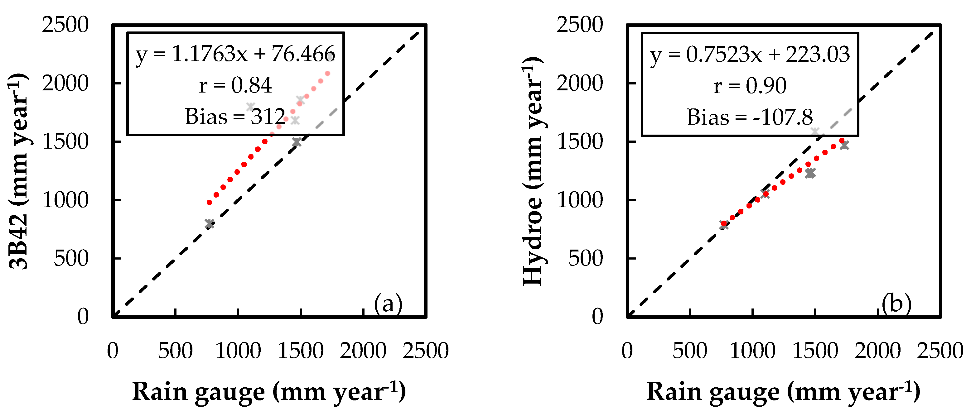
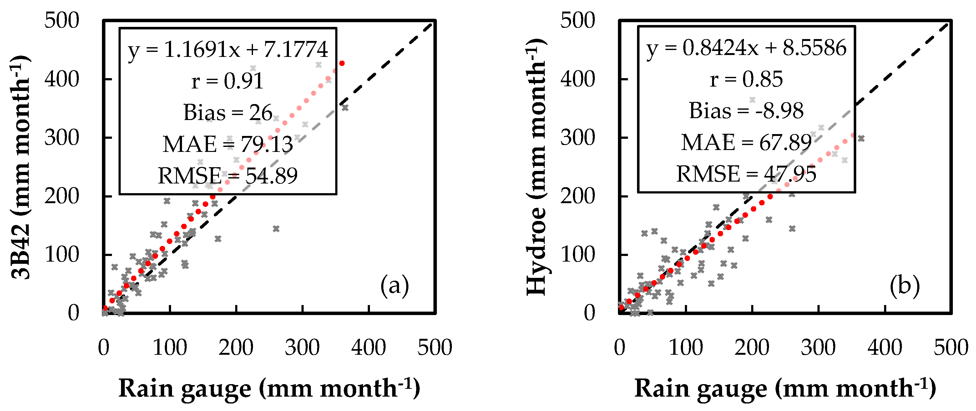
The daily mean value results found here are similar to those reported in previous studies. We found higher r values with the TRMM 3B42 product than Collischonn et al. [
42] and similar values to those reported by Nobrega et al. [
43]. Nobrega et al. [
43] noted that the good performance of TRMM with daily data is linked with the predominance of convective rainfall in the Jamari River Basin, Brazil. Soares et al. [
44] found higher values for the correlation coefficient (between 0.75 and 0.89) than the results in this study (r = 0.70 for TRMM and r = 0.51 with Hydroe). The difference in performance may be related to the precipitation regimes of each region. The Sapucaí watershed has an average annual rainfall of 1200 mm, while Paraíba state, which is located in the semiarid region, varies from 300 to 1000 mm. Studies conducted in the mountainous regions of South Korea [
21] and China [
19] showed different r values. We found higher correlation coefficients with TRMM (r = 0.7,
Figure 6a) and lower coefficients with Hydroe (r = 0.51,
Figure 6b) than those reported by Jiang et al. [
19] (r = 0.66). However, our results were slightly lower than those of Kim et al. [
21], who identified an elevation-dependent performance for the TRMM product with high correlations at low elevations and low correlations at high elevations.
Based on the PSS values (
Table 4), we found that the two satellite products were better at detecting days without rainfall (
p = 0 mm day
−1) than heavy rainfall events. Thus, the better performance may be explained by the greater ability to estimate days without rain than rainy days. These findings need to be interpreted with caution; a previous study [
19] suggested that the capability of TRMM 3B42 at detecting rainfall events is influenced by the combination of the precipitation regime, latitude, and distance to the ocean. In this work, we used the POD to assess the ability of satellite products to estimate heavy rainfall events (rainfall > 11.57 mm day
−1). Ouatiki et al. [
41] and Yuan et al. [
20] applied the POD to detect rainfall events (rainfall > 0.5 mm day
−1) and found lower values than those reported here with the 3B42 product (POD = 0.7). The POD value with the Hydroe product (POD = 0.43) was similar to the values found by Ouatiki et al. [
41] and higher than that reported by Yuan et al. [
20]. The tendency of satellite products to overestimate or underestimate the rainfall over the study area was evaluated. Overall, the Hydroe algorithm showed a negative bias, and TRMM 3B42 showed a positive bias. Falck et al. [
7] studied the rainfall estimated by TRMM 3B42, Hydroe, CMORPH, and GSMaP over the Tocantins-Araguaia catchment in Brazil and found different values: Hydroe exhibited a large positive bias in the middle and lower basins, and 3B42RT showed a bias close to zero in most regions of the basin. TRMM and Hydroe showed behavior specific to each basin; based on these results, they cannot be generalized to other study areas. Alfieri et al. [
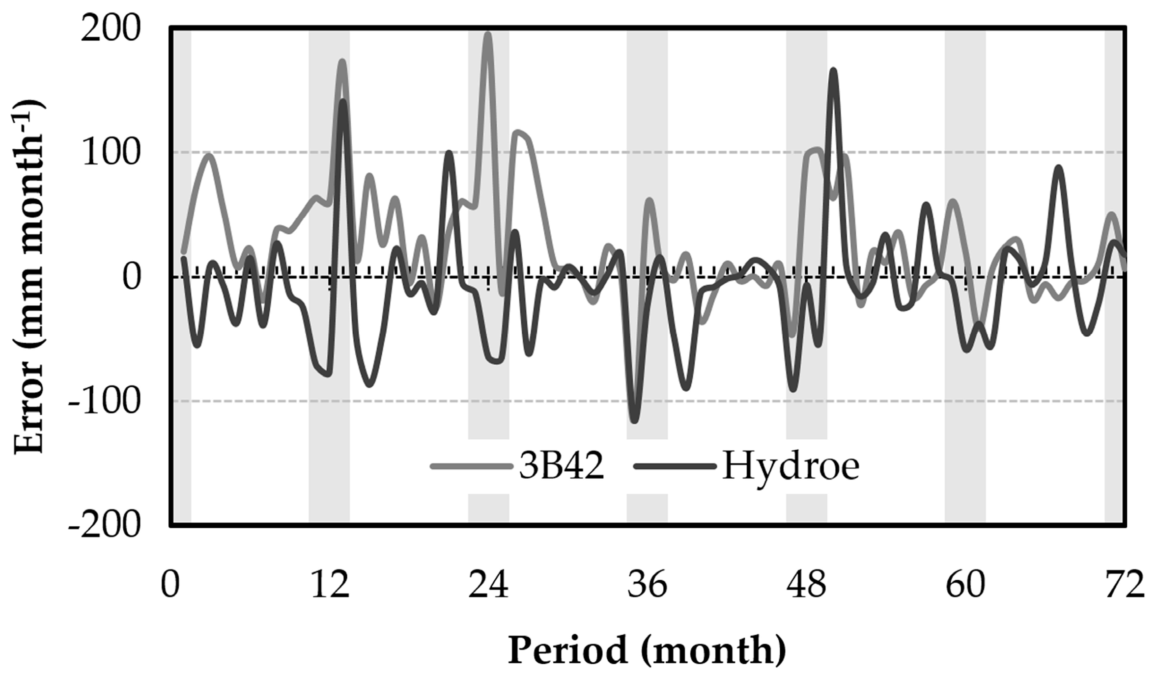
38] considered PSS > 0.5 to be a good indicator of a system’s ability at estimating rainfall values. From this perspective, only the 3B42 product showed values higher than 0.5 for both analyses. Therefore, it presented a better performance than the Hydroe product.
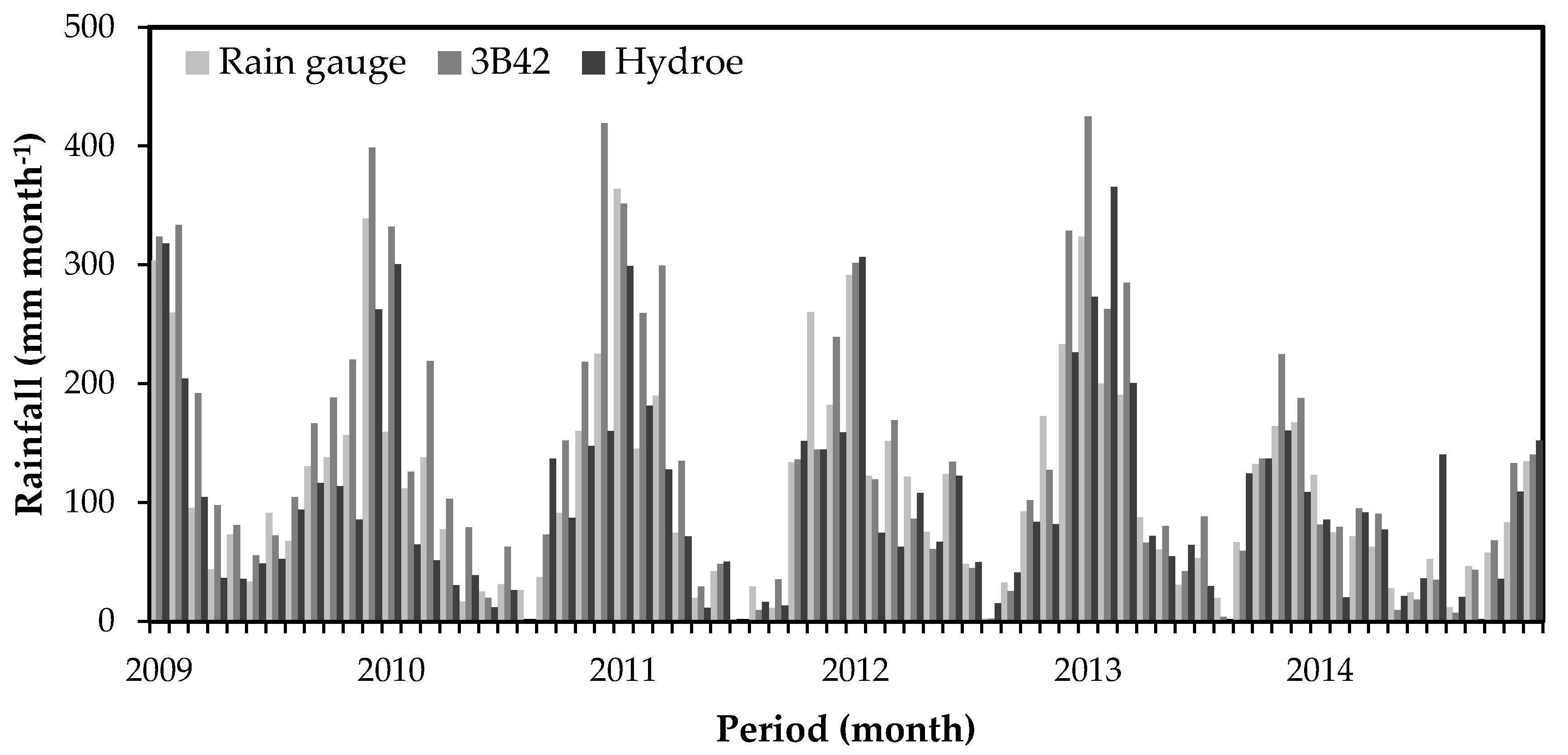
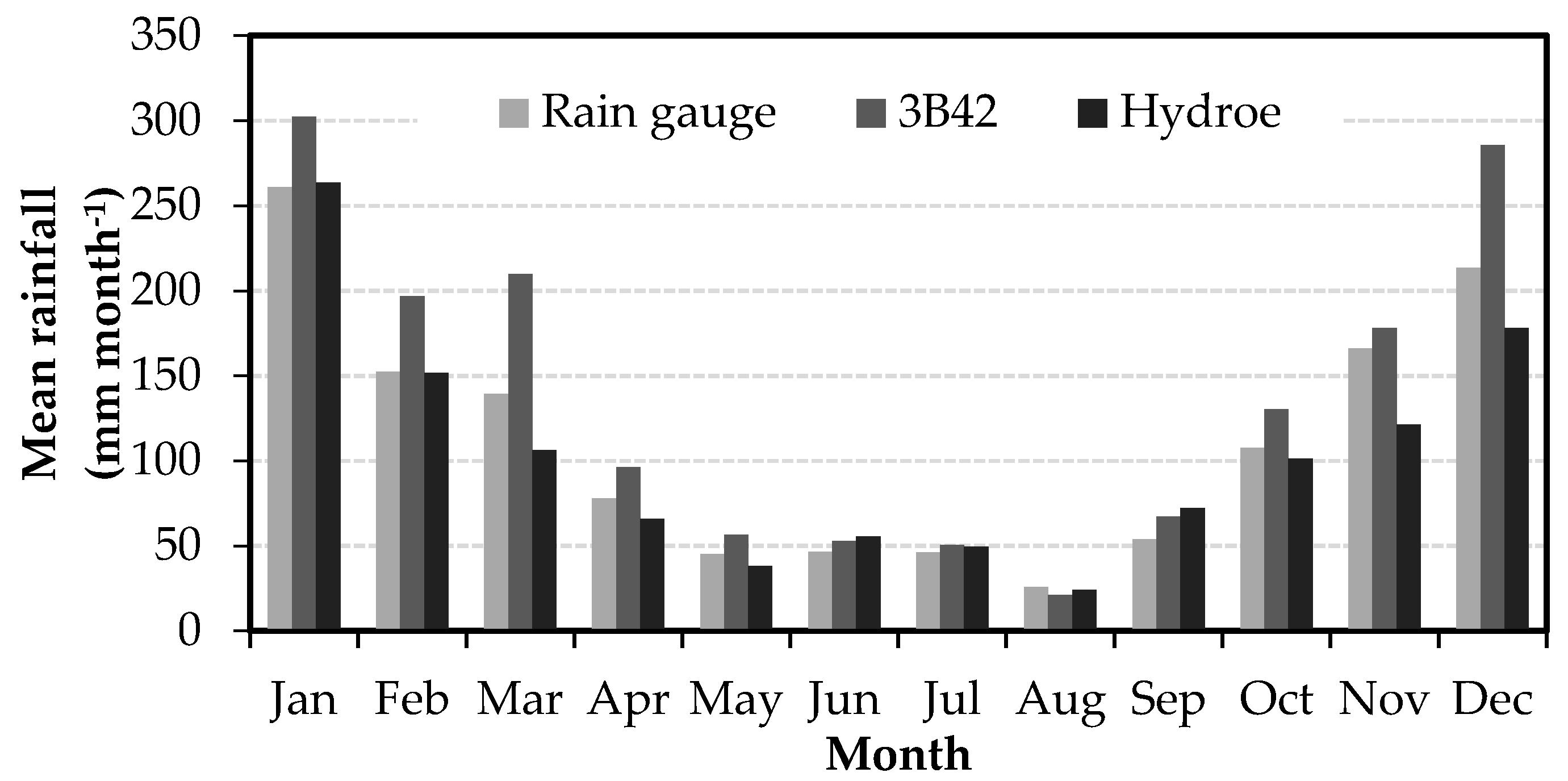
The daily rainfall data were integrated over time to monthly accumulated values. Overall, the satellite products reproduced the monthly rainfall of the watershed with a greater accuracy than the daily products. The monthly rainfall of the study period between January 2009 and December 2014 was used to detect the six rainiest months (October, November, December, January, February and March) and six drier months (April, May, June, July, August and September). This is the same profile found by Rao et al. [
25]. The statistical values for the monthly data showed improvement compared with the results of the daily analysis. However, Curtarelli et al. [
18] evaluated the monthly mean rainfall estimated with the TRMM 3B43 product over the Itumbiara Reservoir drainage area and found higher values (r = 0.96 and relative RMSE lower than 20%). Curtarelli et al. [
18] also found better bias, MAE, and RMSE values with the seasonal evaluation, which indicates that the TRMM 3B43 product provides a reliable estimation of the rainfall over the Itumbiara Reservoir drainage area. Franchito et al. [
9] analyzed data from the TRMM Precipitation Radar (PR) for the southeast region of Brazil and obtained lower values than the two products analyzed here. Oliveira et al. [
45] studied the relation between TRMM data and rain gauges at monthly and annual scales over Brazilian Cerrado. They pointed out that errors in TRMM precipitation were the main source of water budget uncertainty. Oliveira et al. [
45] found similar r and RMSE values to those obtained here with TRMM data but higher than the values found with Hydroe data.
Even though Thiemig et al. [
46] found deficiencies in TRMM 3B42 for mountainous areas in Africa, where the rainfall was generally underestimated, we observed that TRMM tended to overestimate the rainfall over the study area. It still performed better than the Hydroe product. The better performance of TRMM can be linked to its embedded bias correction, which relies on rain gauge data and the multi-sensor technique. However, in order to extend the applications of TRMM products in hydrologic studies, the detection capability of the 3B42 product needs to be enhanced, especially at a daily scale [
19]. In this context, GPM is expected to improve the next generation of global precipitation observation satellites.
5. Conclusions
In this study, satellite rainfall products represented by TRMM 3B42 and Hydroe were evaluated for the quality of their rainfall estimates at different temporal scales based on data from rain gauge stations over the Sapucaí watershed in a humid subtropical climate region of Brazil for the period of January 2009 to December 2014.
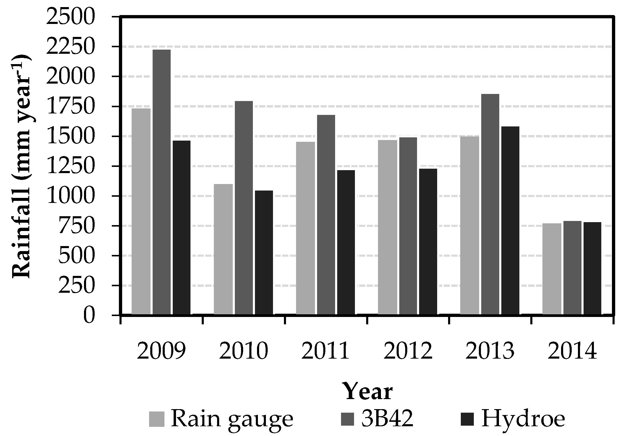
The results showed that TRMM performed better at the daily, monthly, and seasonal scales than Hydroe, while Hydroe presented a lower bias at the annual scale. However, they showed different trends. The TRMM product overestimated rainfall over the watershed at all temporal scales considered, whereas Hydroe underestimated the rainfall except for the JJA season at the seasonal scale, for which it overestimated the rainfall. In addition to the evaluations at different temporal scales, the ability of the satellite products to reproduce observed rainfall was evaluated according to contingency tables, with a focus on discriminating heavy rainfall events and days without rain. The results indicated that the 3B42 product was better able to represent the local heavy rainfall (PSS = 0.61) and days without rain (PSS = 0.63) than the Hydroe product (PSS = 0.37 for heavy rainfall events and 0.47 for days without rain). The findings of this study indicate that satellite rainfall products are better suited for applications at monthly and annual scales than at the daily scale, although further improvements are needed to reduce the errors of the daily data.
This study helps in enhancing our understanding of the accuracy of two satellite products (TRMM 3B42 v7 and Hydroe). However, given the sample size, the period analyzed, and the characteristics of the region, caution must be taken when considering the results presented. In summary, the results allow for discrimination between available products depending on the applications needed for regions with sparse or no rain gauge coverage, although the errors, uncertainties, potential, and limitations need to be kept in mind. Despite the differences between satellite rainfall data and ground data, this work emphasizes the use of remotely sensing data. Overall, the TRMM and Hydroe products were evaluated for their ability to estimate the rainfall over the Sapucaí watershed. The evaluation in this specific watershed is especially attractive for the community because it shows how precise rainfall estimates by remote sensing are over a mountainous region, which usually has a poor spatial coverage of rain gauge stations around the world. The results will be helpful for investigations or applications in hydrologic studies, such as managing floods. Further investigations should be conducted to examine the potential of calibration and bias correction for satellite products based on rain gauge data and the propagation of satellite precipitation uncertainties through a hydrologic model.


