Detection of Archaeological Residues in Vegetated Areas Using Satellite Synthetic Aperture Radar


Abstract
:
1. Introduction
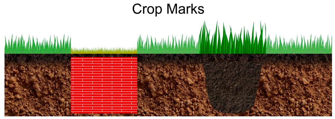
1.1. Archaeological Residues
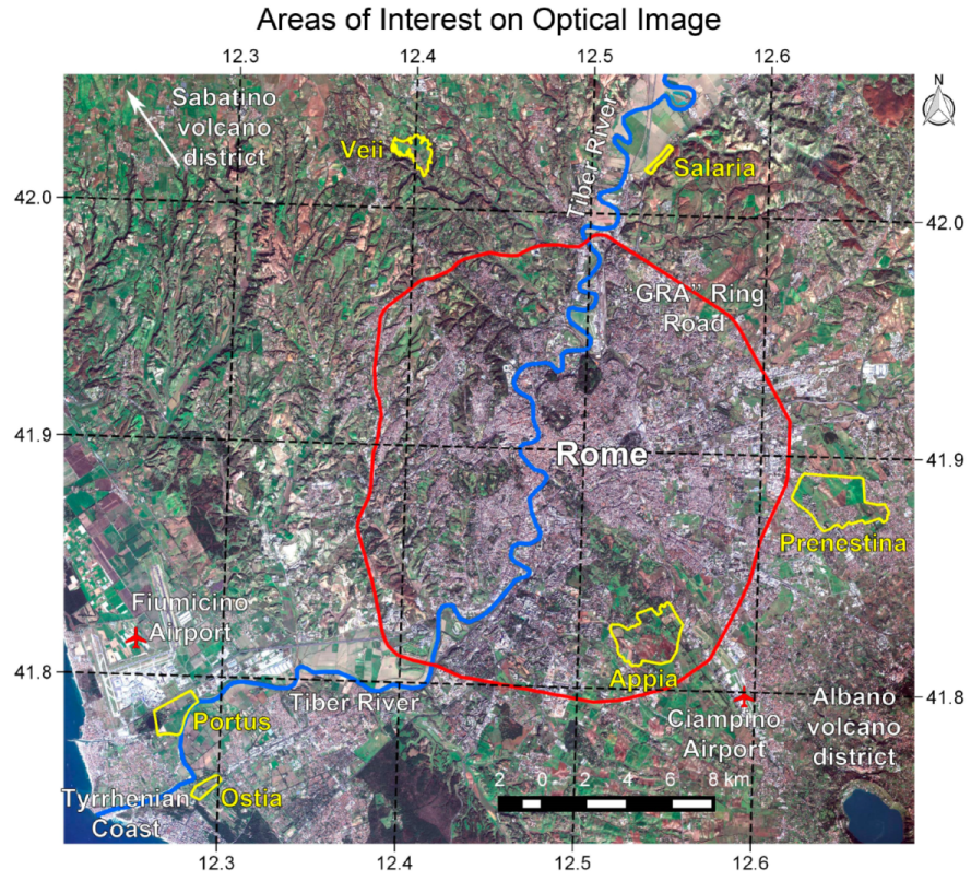
1.2. Study Areas
2. Materials
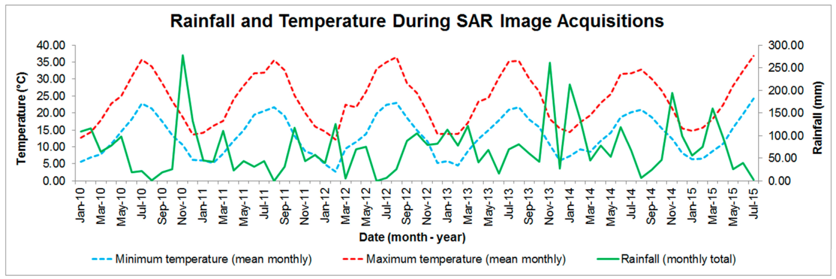
SAR Data
3. Methods
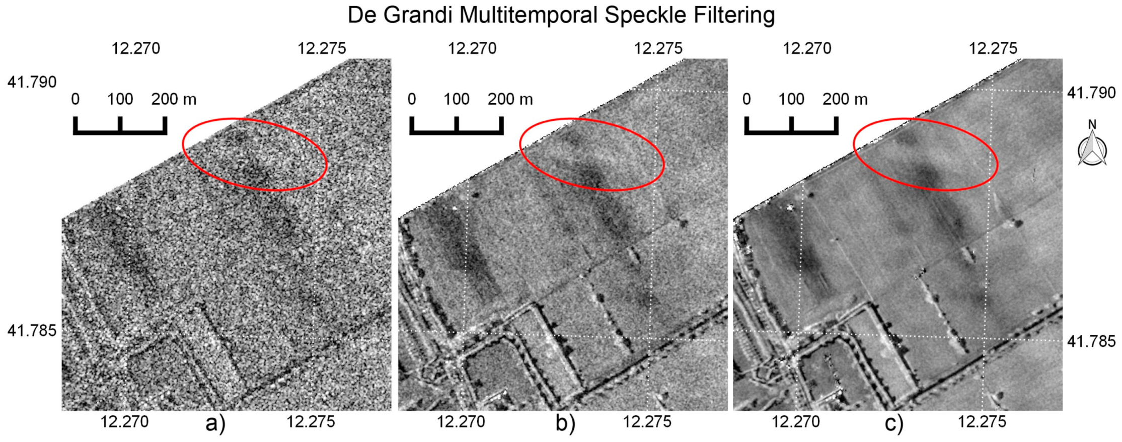
3.1. Multitemporal Speckle Filtered σ0 Backscatter
3.2. Interferometric Coherence
3.3. DEM
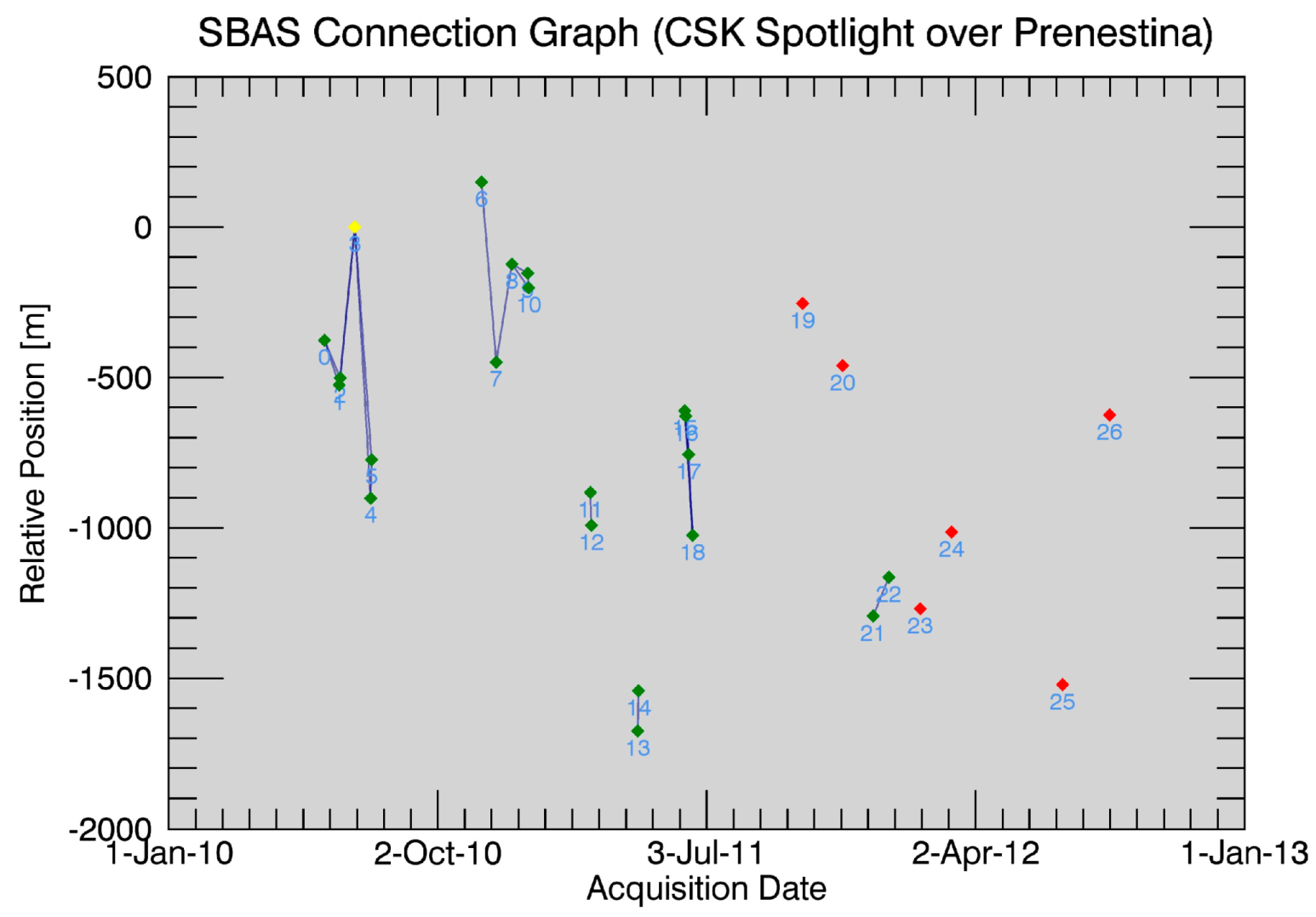
3.3.1. SBAS DEM: Prenestina AOI
3.3.2. InSAR DEM: Salaria AOI
3.4. GIS
3.5. Analysis of Features
3.5.1. Mean Ratio Detector (MRD)
3.5.2. Potential Soil Moisture Deficit (PSMD)
3.5.3. Coherence
4. Results
4.1. Portus
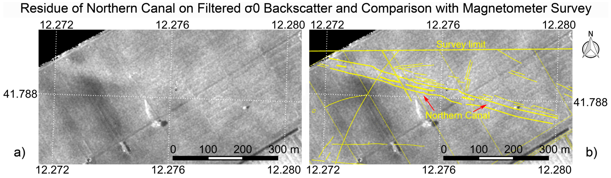
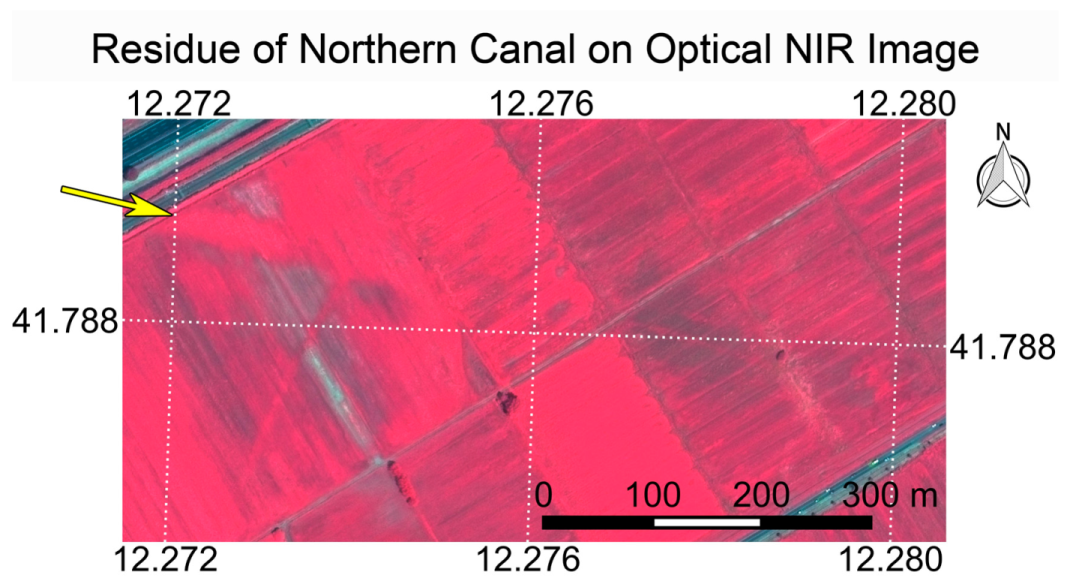
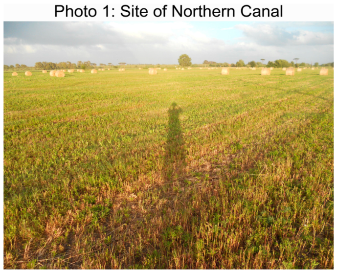
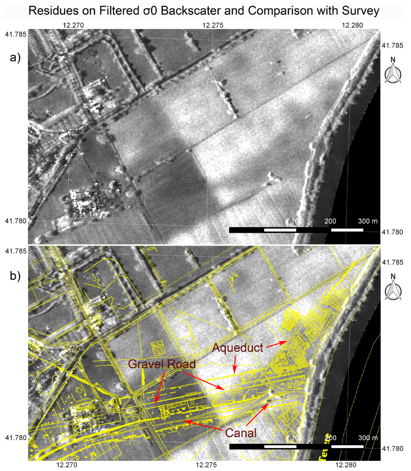
4.1.1. Portus Northern Canal
4.1.2. Portus Southern Urban Area
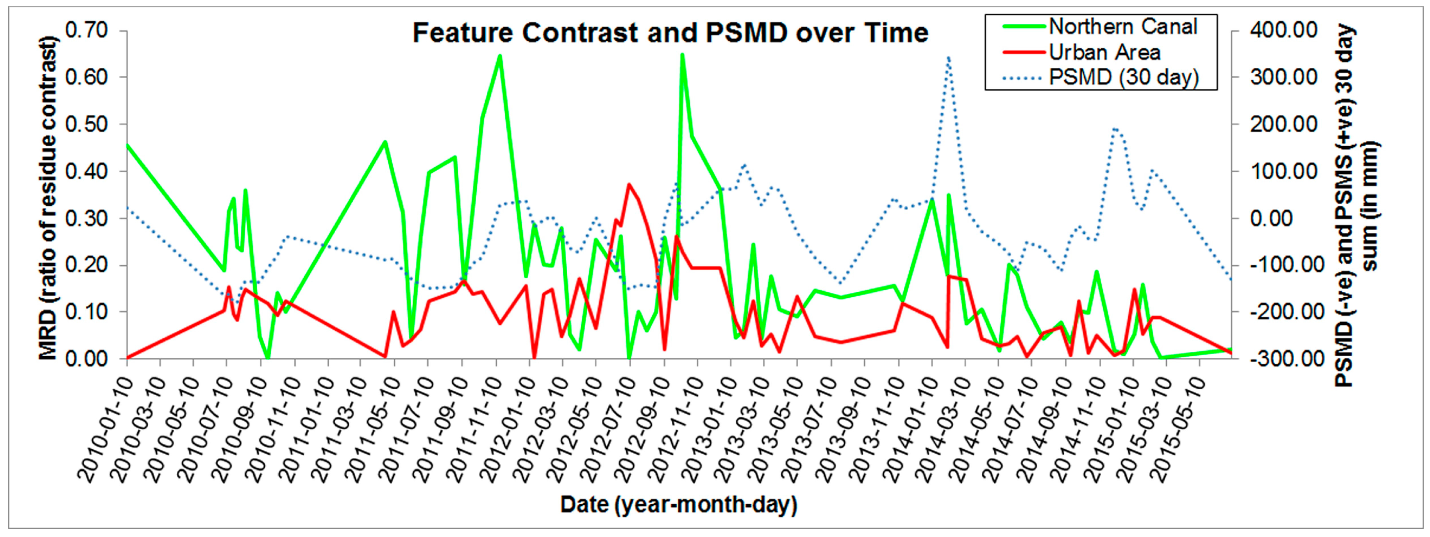
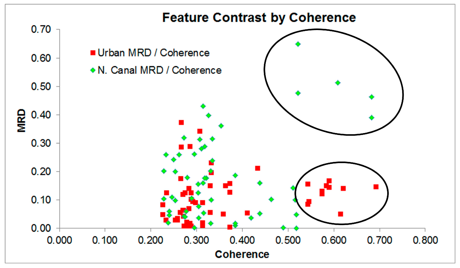
4.1.3. Portus Features Analysis
4.2. Ostia
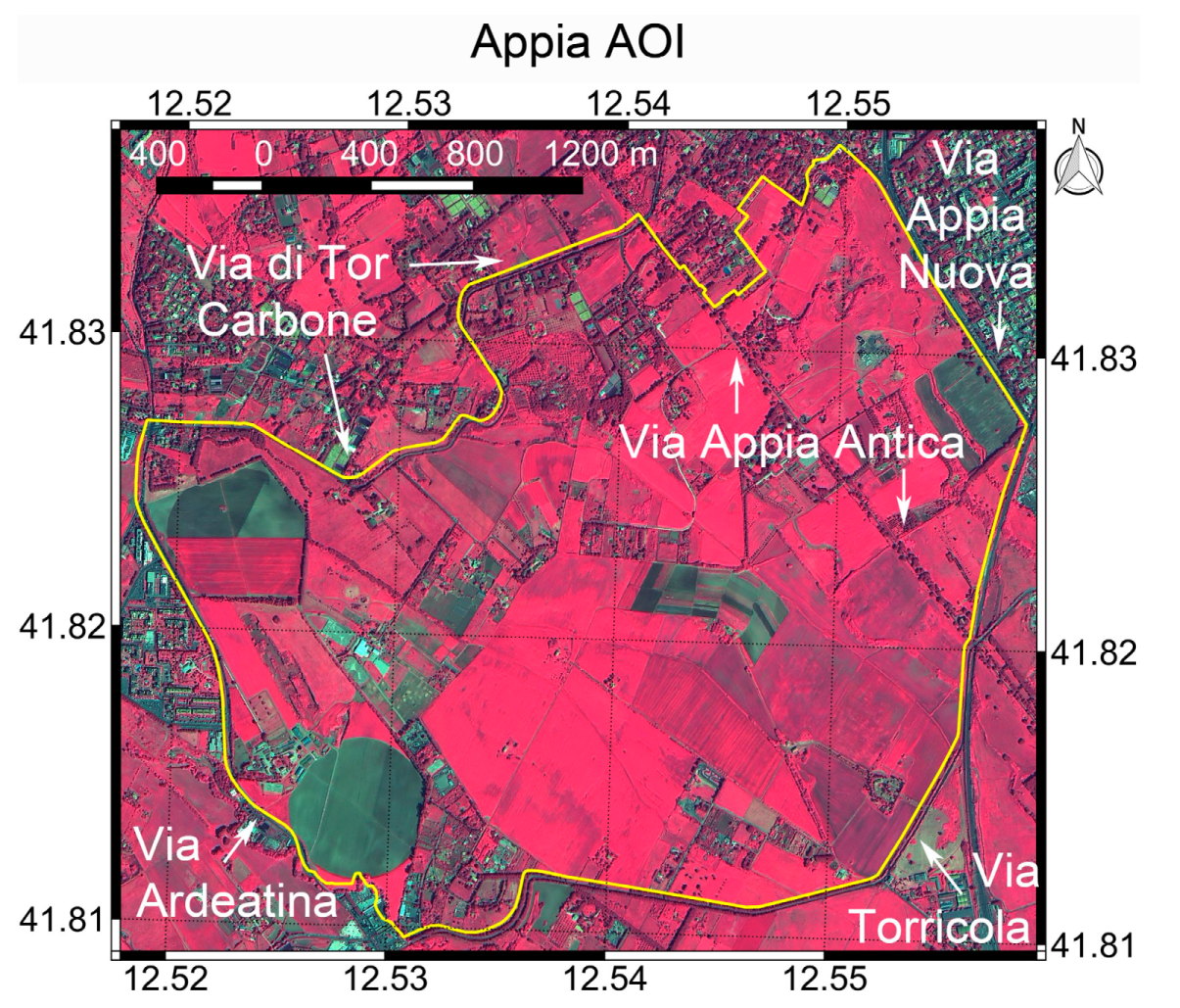
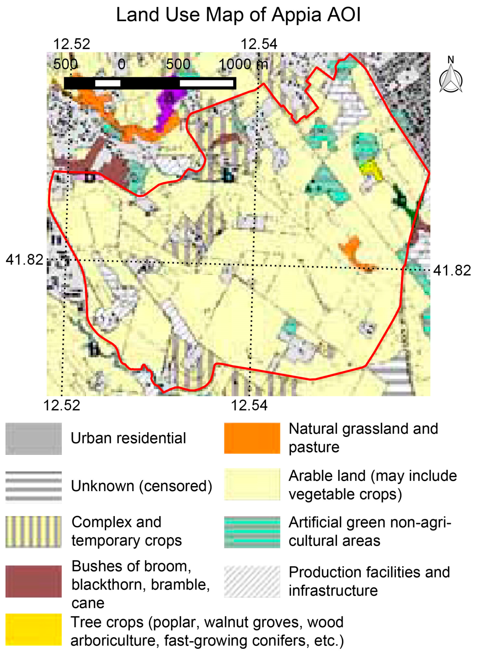
4.3. Appia
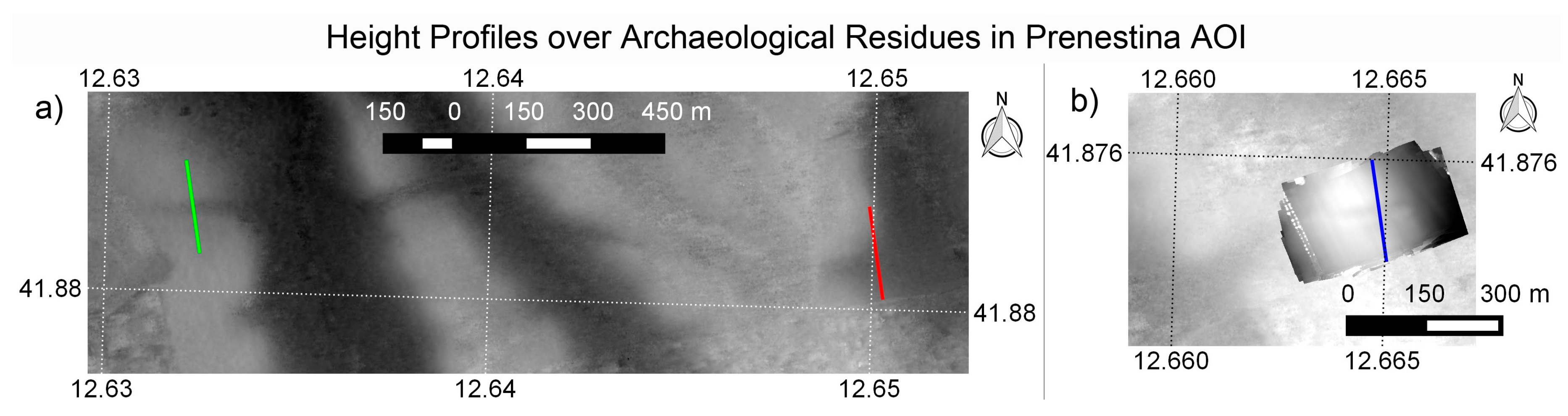
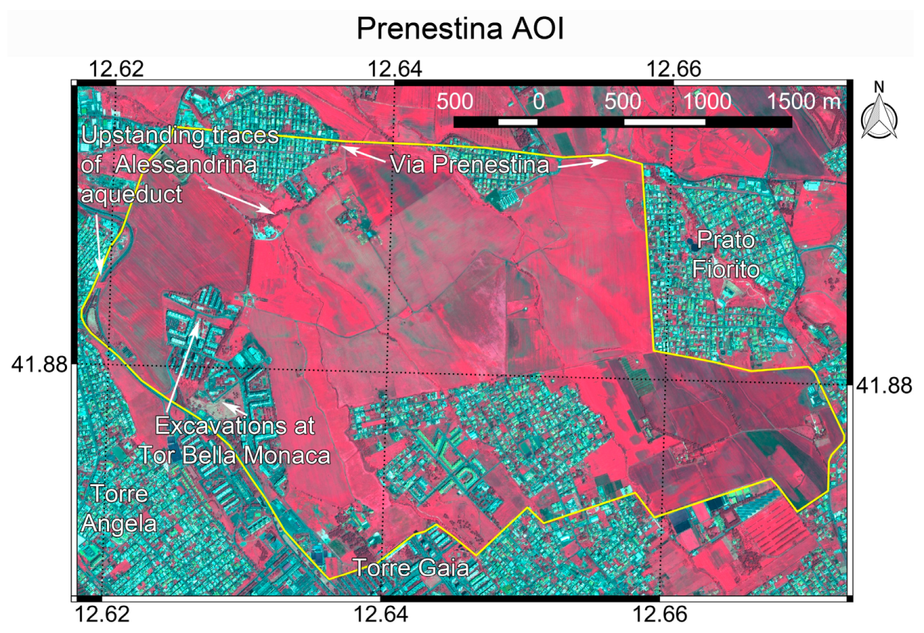
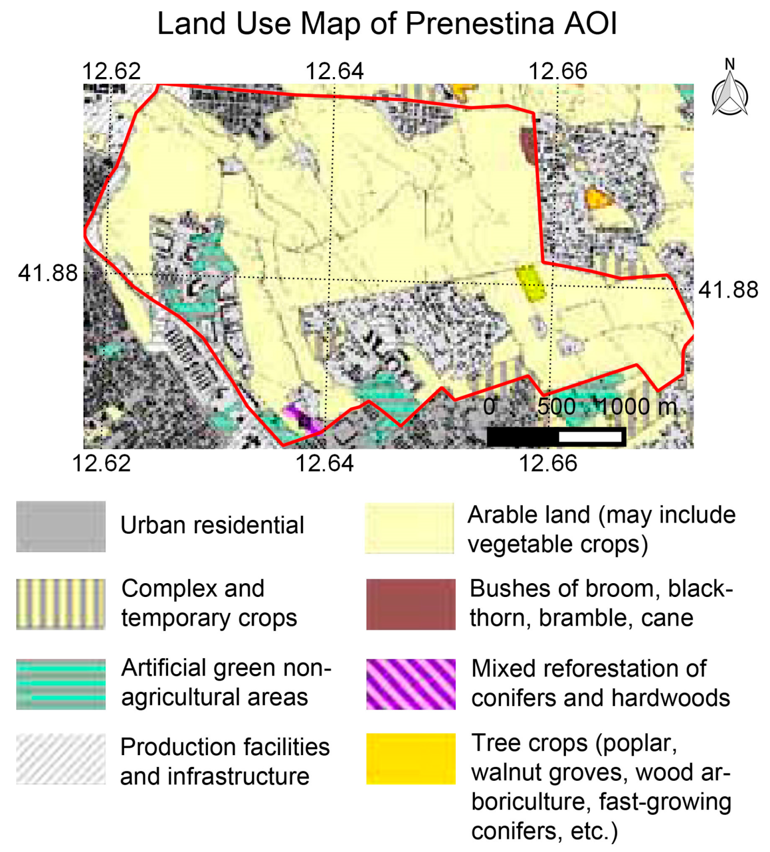
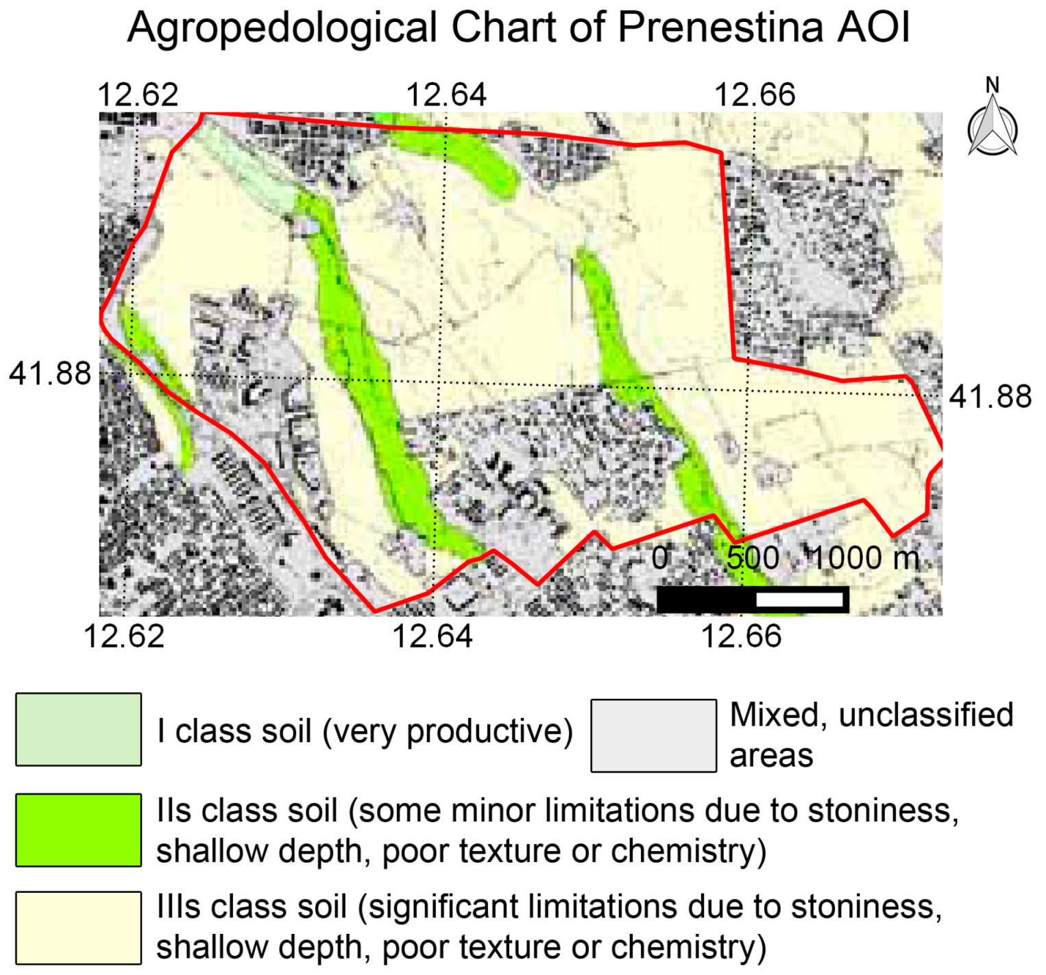
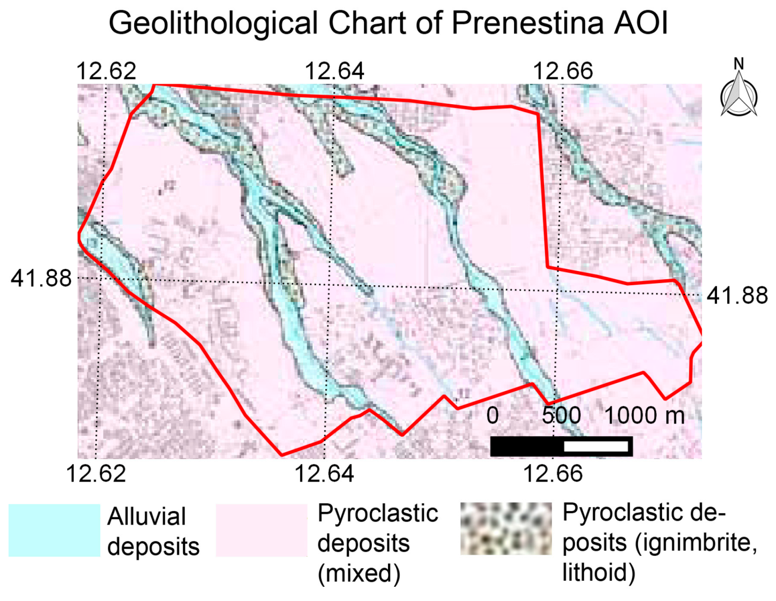
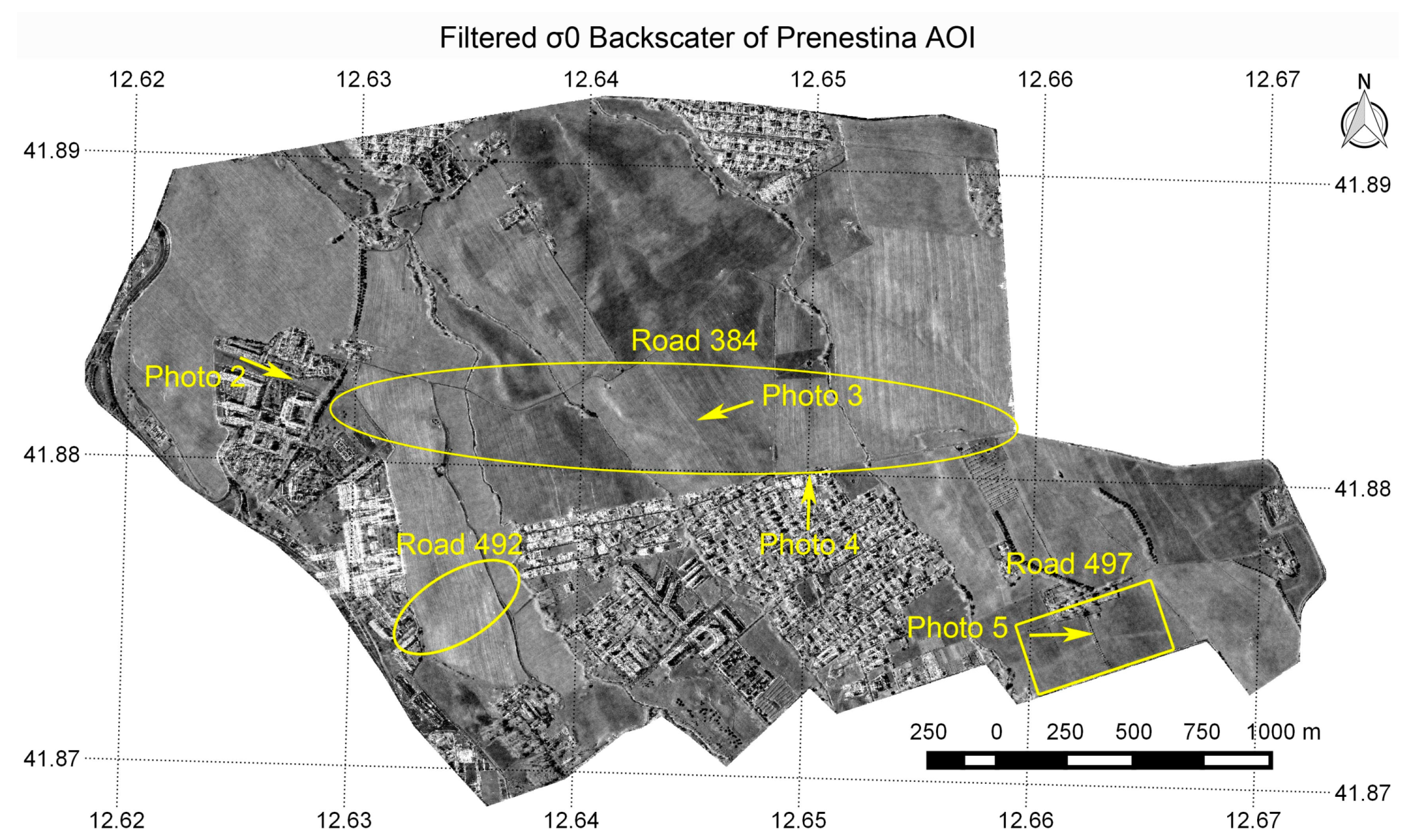
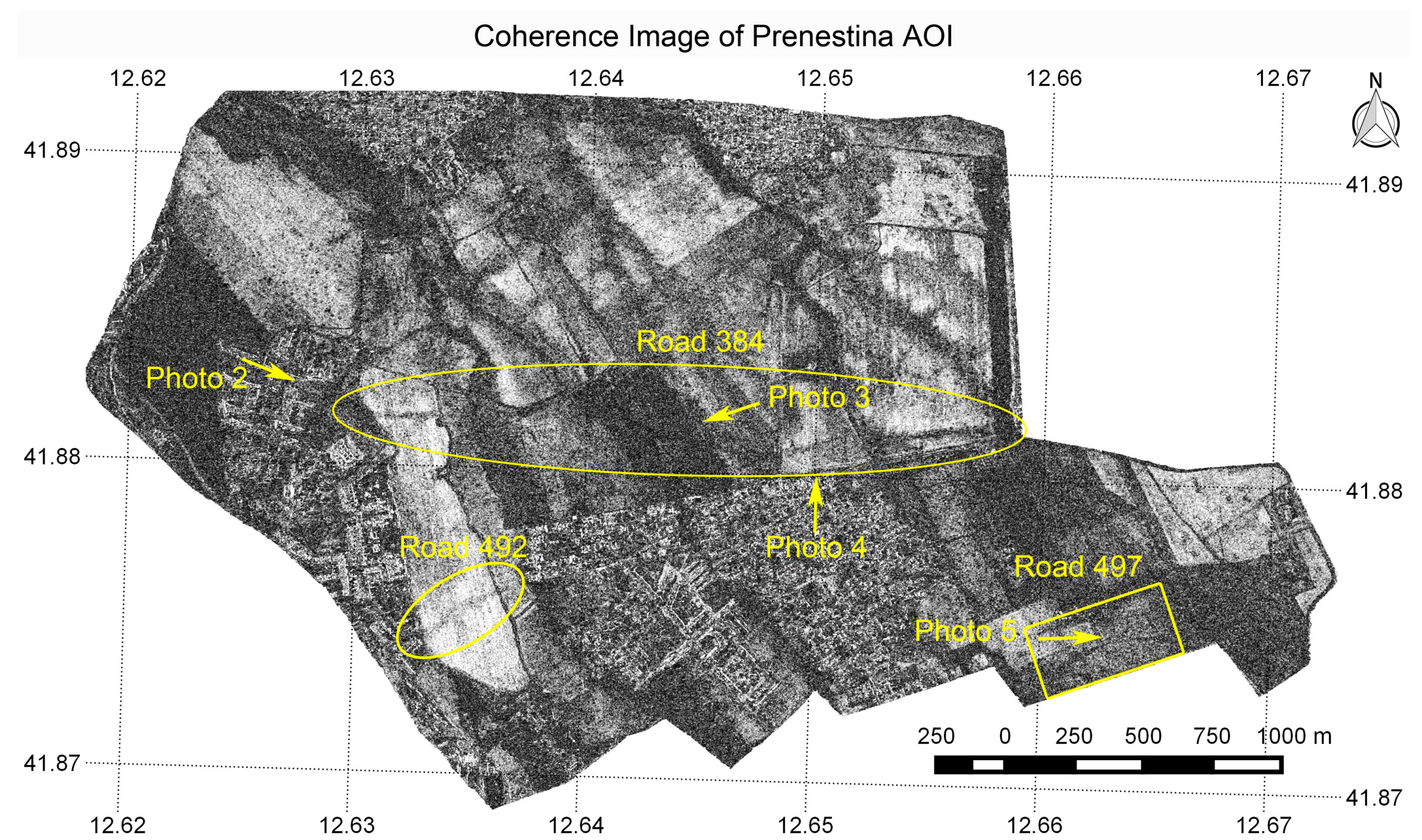
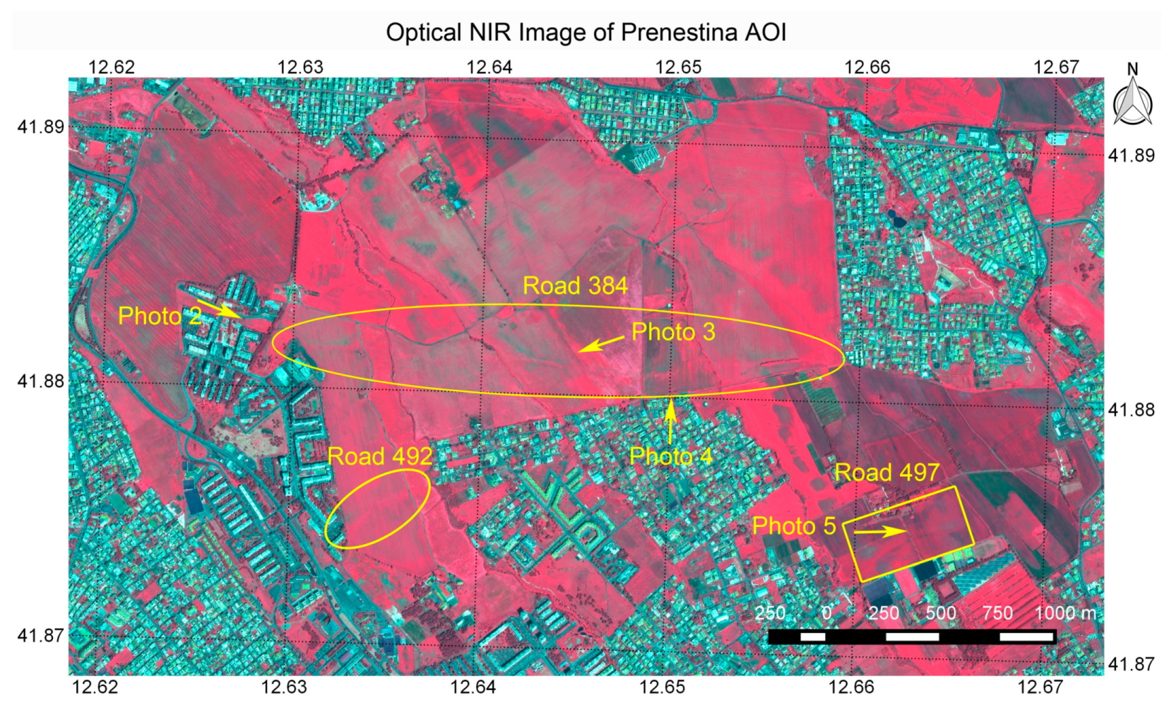
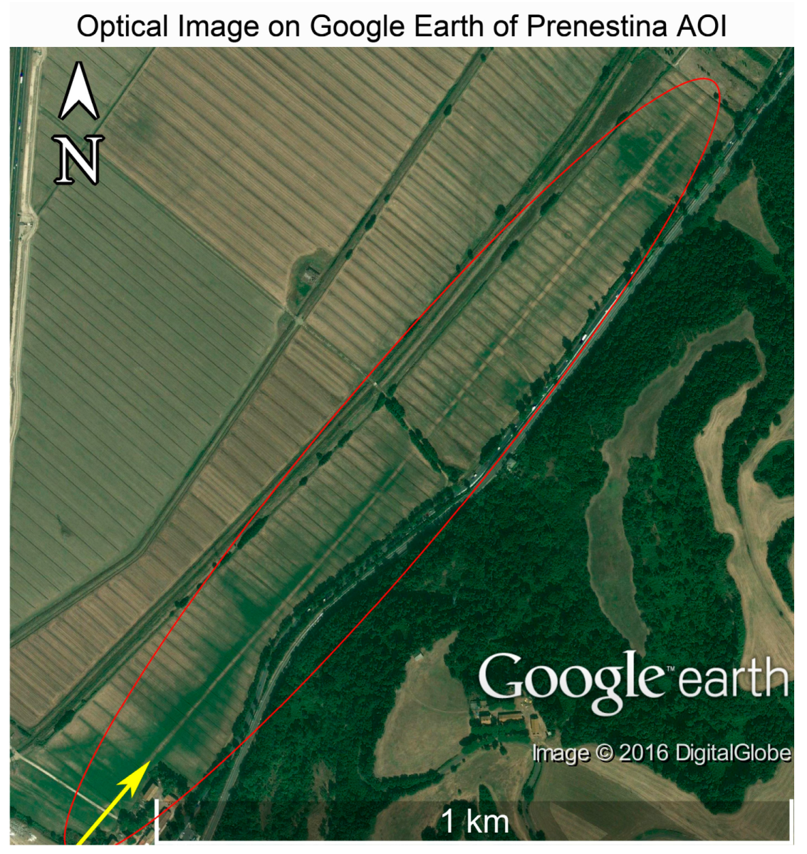
4.4. Prenestina
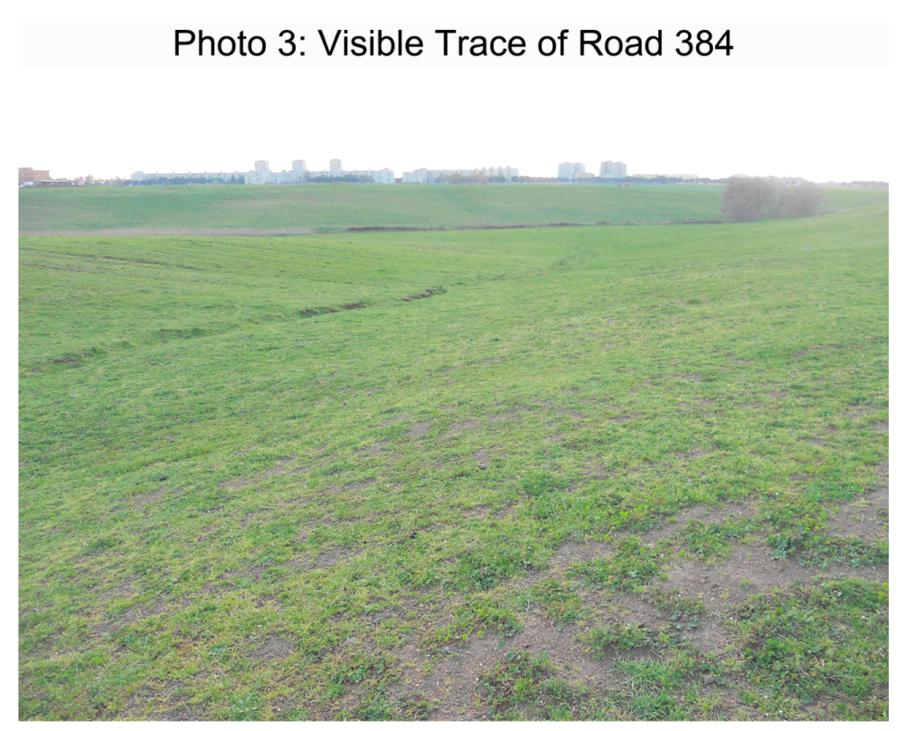
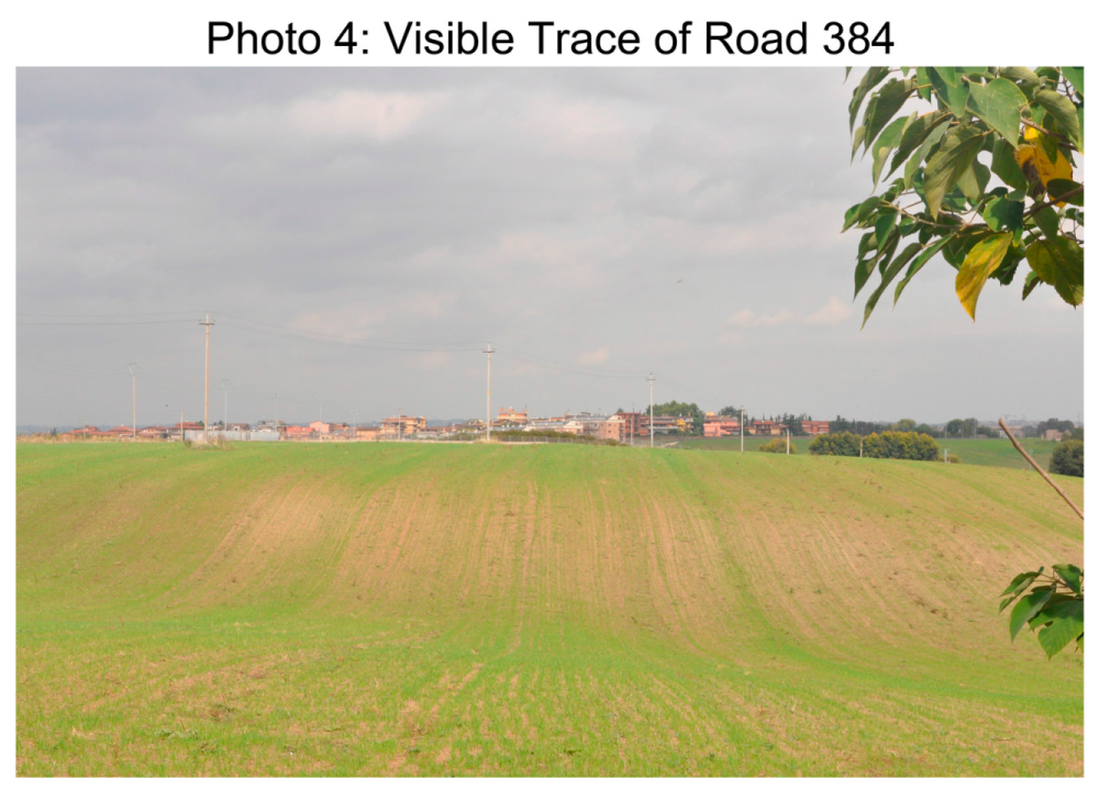
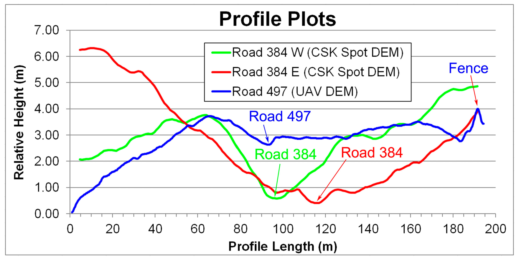
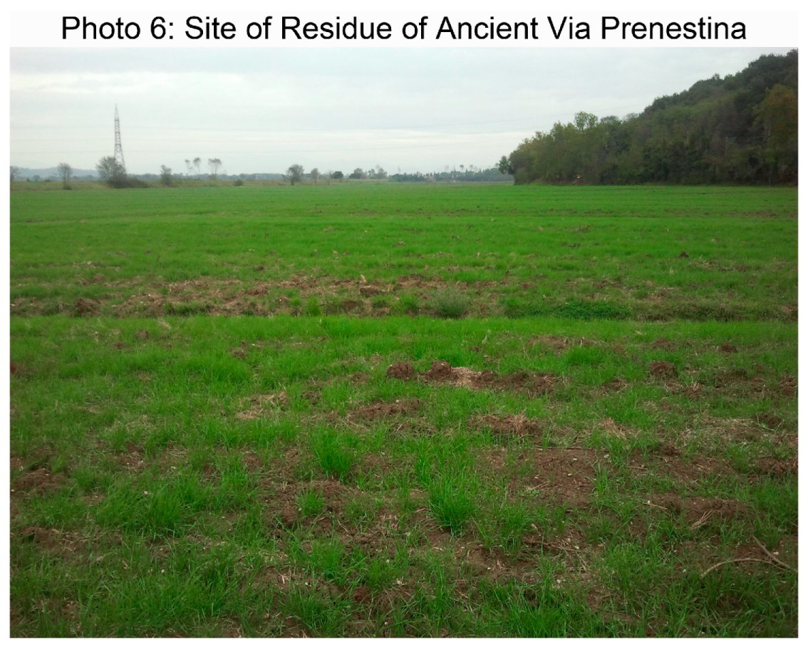
4.4.1. Road 384
4.4.2. Road 492
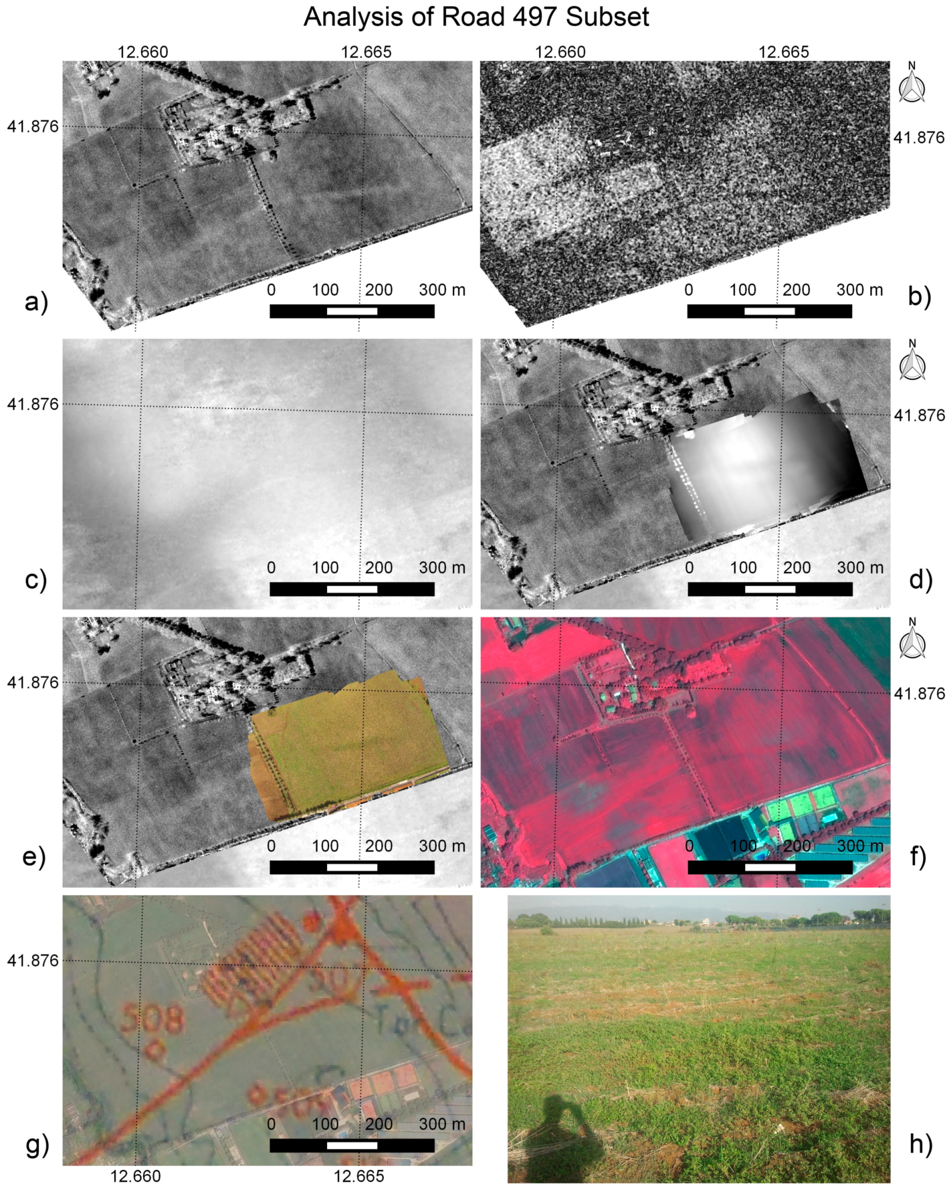
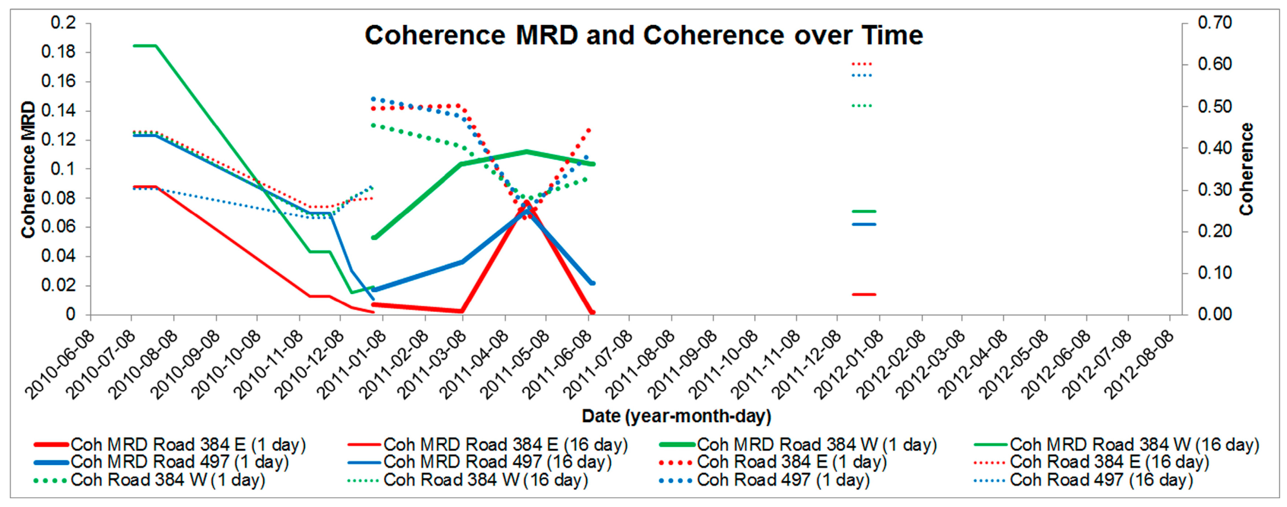
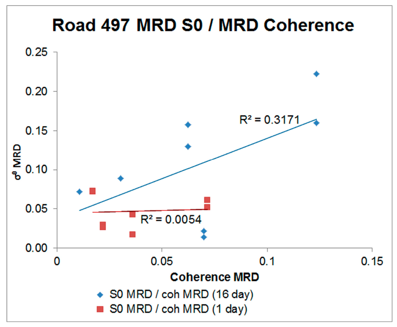
4.4.3. Road 497
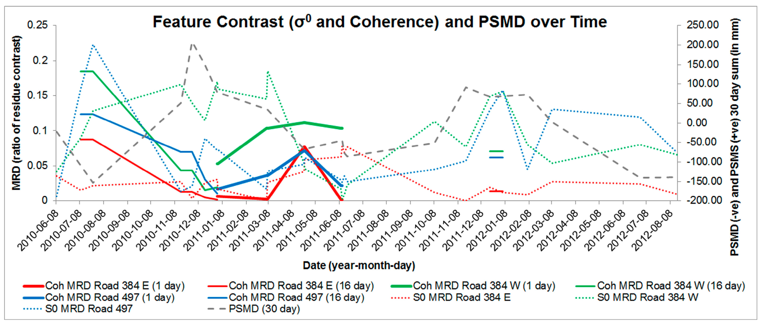
4.4.4. Prenestina Features Analysis
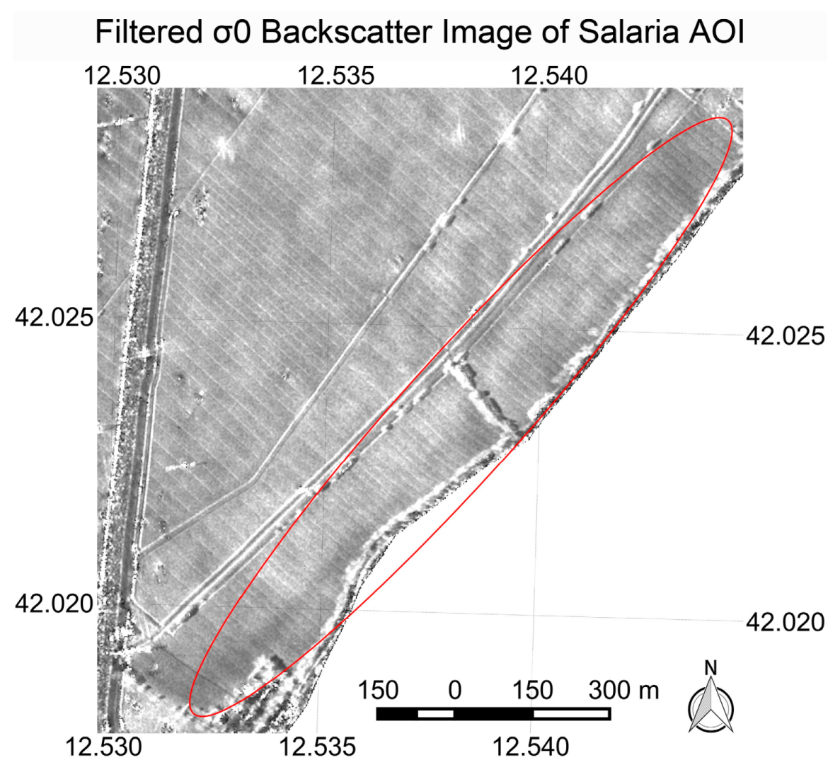
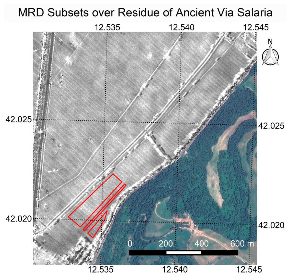
4.5. Salaria
Salaria Features Analysis
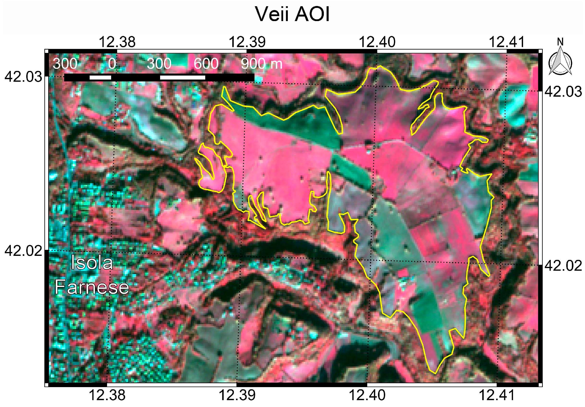
4.6. Veii
5. Discussion
5.1. Filtered σ0 Backscatter
5.1.1. Filtered σ0 Residues Due to High Relative Backscatter
5.1.2. Filtered σ0 Residues Due to Low Relative Backscatter
5.2. Coherence
5.3. DEM
6. Conclusions
Supplementary Materials
Acknowledgments
Conflicts of Interest
References
- Jones, R.; Evans, R. Soil and crop marks in the recognition of archaeological sites by air photography. In Aerial Reconnaissance for Archaeology; Archaeology Data Service: York, UK, 1975; pp. 1–11. [Google Scholar]
- Stanjek, H.; Fassbinder, J. Soil aspects affecting archaeological details in aerial photographs. Archaeol. Prospect. 1995, 2, 91–102. [Google Scholar]
- Wilson, D.R. Air Photo Interpretation for Archaeologists; Tempus Publishing: Stroud, UK, 2000. [Google Scholar]
- Lasaponara, R.; Masini, N. Satellite Remote Sensing: A New Tool for Archaeology; Springer Science & Business Media: New York, NY, USA, 2012; Volume 16. [Google Scholar]
- Evans, R.; Jones, R. Crop marks and soils at two archaeological sites in britain. J. Archaeol. Sci. 1977, 4, 63–76. [Google Scholar] [CrossRef]
- Lasaponara, R.; Masini, N. Remote sensing in archaeology: From visual data interpretation to digital data manipulation. In Satellite Remote Sensing; Springer: Berlin/Heidelberg, Germany, 2012; pp. 3–16. [Google Scholar]
- Kaimaris, D.; Patias, P.; Tsakiri, M. Best period for high spatial resolution satellite images for the detection of marks of buried structures. Egypt. J. Remote Sens. Space Sci. 2012, 15, 9–18. [Google Scholar] [CrossRef]
- Agapiou, A.; Alexakis, D.D.; Hadjimitsis, D.G. Spectral sensitivity of alos, aster, ikonos, landsat and spot satellite imagery intended for the detection of archaeological crop marks. Int. J. Digit. Earth 2014, 7, 351–372. [Google Scholar] [CrossRef]
- Agapiou, A.; Hadjimitsis, D.G.; Sarris, A.; Georgopoulos, A.; Alexakis, D.D. Optimum temporal and spectral window for monitoring crop marks over archaeological remains in the mediterranean region. J. Archaeol. Sci. 2013, 40, 1479–1492. [Google Scholar] [CrossRef]
- Rączkowski, W. Cropmarks 2011 in poland—Is there a need for further discussion? AARGnews 2011, 43, 37–42. [Google Scholar]
- Crawford, O.G.S. Air survey and archaeology. Geogr. J. 1923, 61, 342–360. [Google Scholar] [CrossRef]
- Knipling, E.B. Physical and physiological basis for the reflectance of visible and near-infrared radiation from vegetation. Remote Sens. Environ. 1970, 1, 155–159. [Google Scholar] [CrossRef]
- Gates, D.M. Biophysical Ecology; Springer: New York, NY, USA, 1980; p. 614. [Google Scholar]
- Myneni, R.B.; Hall, F.G.; Sellers, P.J.; Marshak, A.L. The interpretation of spectral vegetation indexes. IEEE Trans. Geosci. Remote Sens. 1995, 33, 481–486. [Google Scholar] [CrossRef]
- Lasaponara, R.; Masini, N. Detection of archaeological crop marks by using satellite quickbird multispectral imagery. J. Archaeol. Sci. 2007, 34, 214–221. [Google Scholar] [CrossRef]
- Agapiou, A.; Alexakis, D.D.; Sarris, A.; Hadjimitsis, D.G. Orthogonal equations of multi-spectral satellite imagery for the identification of un-excavated archaeological sites. Remote Sens. 2013, 5, 6560–6586. [Google Scholar] [CrossRef]
- Cavalli, R.M.; Colosi, F.; Palombo, A.; Pignatti, S.; Poscolieri, M. Remote hyperspectral imagery as a support to archaeological prospection. J. Cult. Herit. 2007, 8, 272–283. [Google Scholar] [CrossRef]
- Doneus, M.; Verhoeven, G.; Atzberger, C.; Wess, M.; Ruš, M. New ways to extract archaeological information from hyperspectral pixels. J. Archaeol. Sci. 2014, 52, 84–96. [Google Scholar] [CrossRef]
- Atzberger, C.; Wess, M.; Doneus, M.; Verhoeven, G. Arctis—A Matlab® Toolbox for archaeological imaging spectroscopy. Remote Sens. 2014, 6, 8617–8638. [Google Scholar] [CrossRef]
- Ben-Dor, E.; Portugali, J.; Kochavi, M.; Shimoni, M.; Vinitzky, L. Airborne thermal video radiometry and excavation planning at Tel Leviah, Golan Heights, Israel. J. Field Archaeol. 2013, 26, 117–127. [Google Scholar] [CrossRef]
- McManus, K.; Donoghue, D. Airborne Thermography of the Vegetation-Soil Interface for Detecting Shallow Ground Disturbance. Space Applications for Heritage Conservation. In Proceedings of the EGS XXVII General Assembly, Nice, France, 21–26 April 2002; p. 31.
- Verhoeven, G.J.; Schmitt, K.D. An attempt to push back frontiers–digital near-ultraviolet aerial archaeology. J. Archaeol. Sci. 2010, 37, 833–845. [Google Scholar] [CrossRef]
- Ulaby, T.; Moore, K.; Fung, K. Microwave Remote Sensing. Volume II: Radar Remote Sensing and Surface Scattering and Emission Theory; Addison Wesley: New York, NY, USA, 1982; Volume 2. [Google Scholar]
- McCauley, J.F.; Schaber, G.G.; Breed, C.S.; Grolier, M.J.; Haynes, C.V.; Issawi, B.; Elachi, C.; Blom, R. Subsurface valleys and geoarcheology of the eastern sahara revealed by shuttle radar. Science 1982, 218, 1004–1020. [Google Scholar] [CrossRef] [PubMed]
- Schaber, G.G.; McCauley, J.F.; Breed, C.S.; Olhoeft, G.R. Shuttle imaging radar: Physical controls on signal penetration and subsurface scattenng in the eastern sahara. IEEE Trans. Geosci. Remote Sens. 1986, 603–623. [Google Scholar] [CrossRef]
- Paillou, P.; Grandjean, G.; Baghdadi, N.; Heggy, E.; August-Bernex, T.; Achache, J. Subsurface imaging in south-central egypt using low-frequency radar: Bir safsaf revisited. IEEE Trans. Geosci. Remote Sens. 2003, 41, 1672–1684. [Google Scholar] [CrossRef]
- Morrison, K. Mapping subsurface archaeology with sar. Archaeol. Prospect. 2013, 20, 149–160. [Google Scholar] [CrossRef]
- Gaber, A.; Koch, M.; Griesh, M.H.; Sato, M.; El-Baz, F. Near-surface imaging of a buried foundation in the western desert, egypt, using space-borne and ground penetrating radar. J. Archaeol. Sci. 2013, 40, 1946–1955. [Google Scholar] [CrossRef]
- Stewart, C.; Lasaponara, R.; Schiavon, G. Alos palsar analysis of the archaeological site of pelusium. Archaeol. Prospect. 2013, 20, 109–116. [Google Scholar] [CrossRef]
- Dubois, P.C.; Van Zyl, J.; Engman, T. Measuring soil moisture with imaging radars. IEEE Trans. Geosci. Remote Sens. 1995, 33, 915–926. [Google Scholar] [CrossRef]
- Rosen, P.A.; Hensley, S.; Joughin, I.R.; Li, F.K.; Madsen, S.N.; Rodriguez, E.; Goldstein, R.M. Synthetic Aperture Radar interferometry. Proc. IEEE 2000, 88, 333–382. [Google Scholar] [CrossRef]
- Lanari, R.; Casu, F.; Manzo, M.; Zeni, G.; Berardino, P.; Manunta, M.; Pepe, A. An overview of the small baseline subset algorithm: A dinsar technique for surface deformation analysis. Pure Appl. Geophys. 2007, 164, 637–661. [Google Scholar] [CrossRef]
- Moore, E.; Freeman, A. The Application of Microwave Scattering Mechanism to the Study of Early Ankorean Water Management. Paper Read at European Association of Southeast Asian Archaeologists. In Proceedings of the 6th International Conference, Leiden, The Netherlands, 2–6 September 1996; pp. 1–13.
- Moore, E.; Freeman, T.; Hensley, S. Spaceborne and airborne radar at Angkor: Introducing new technology to the ancient site. In Remote Sensing in Archaeology; Springer: Berlin/Heidelberg, Germany, 2007; pp. 185–216. [Google Scholar]
- Sheets, P.; Sever, T.L. Creating and perpetuating social memory across the ancient Costa Rican Landscape. In Remote Sensing in Archaeology; Springer: Berlin/Heidelberg, Germany, 2006; pp. 161–184. [Google Scholar]
- Stewart, C.; Lasaponara, R.; Schiavon, G. Multi-frequency, polarimetric SAR analysis for archaeological prospection. Int. J. Appl. Earth Observ. Geoinform. 2014, 28, 211–219. [Google Scholar] [CrossRef]
- Stewart, C.; Di Iorio, A.; Schiavon, G. Analysis of the utility of COSMO SkyMed stripmap to detect buried archaeological features in the region of Rome. In Proceedings of the 4th EARSeL Workshop on Cultural and Natural Heritage, Matera, Italy, 6–7 June 2013; Lasaponara, R., Masini, N., Biscione, M., Hernandez, M., Eds.; European Association of Remote Sensing Laboratories (EARSeL): Matera, Italy, 2013; pp. 203–212. [Google Scholar]
- Chen, F.; Masini, N.; Yang, R.; Milillo, P.; Feng, D.; Lasaponara, R. A space view of radar archaeological marks: First applications of COSMO-SkyMed X-band data. Remote Sens. 2015, 7, 24–50. [Google Scholar] [CrossRef]
- Sever, T.L.; Irwin, D.E. Landscape archaeology: Remote-sensing investigation of the ancient maya in the peten rainforest of Northern Guatemala. Anc. Mesoam. 2003, 14, 113–122. [Google Scholar] [CrossRef]
- Comer, D.C.; Blom, R.G. Detection and identification of archaeological sites and features using Synthetic Aperture Radar (SAR) data collected from airborne platforms. In Remote Sensing in Archaeology; Springer: Berlin/Heidelberg, Germany, 2006; pp. 103–136. [Google Scholar]
- Funiciello, R.; Heiken, G.; De Rita, D. I Sette Colli: Guida Geologica a una Roma Mai Vista; Raffaello Cortina: Milano, Italy, 2006. [Google Scholar]
- Centro Funzionale Regionale. Available online: http://www.idrografico.roma.it/ (accessed on 20 October 2016).
- Keay, S.; Millett, M.; Paroli, L.; Strutt, K. Portus: An Archaeological Survey of the Port of Imperial Rome; British School at Rome: London, UK, 2005; Volume 15, p. 360. [Google Scholar]
- Becker, H. Prospecting in Ostia Antica (Italy) and the Discovery of the Basilica of Constantinus I. In 1996. ICOMOS Hefte Dtsch. Natl. 2015, 33, 139–143. [Google Scholar]
- Mols, S. Mapping the via appia. Forma Urbis 2014, XIX, 4. [Google Scholar]
- Quilici, L. Collatia; De Luca Editore: Rome, Italy, 1974; Volume Regio 1, p. 938. [Google Scholar]
- Quilici, L.; Gigli, S.Q. Crustumerium; Consiglio Nazionale Delle Ricerche, Centro di Studio per L’archeologia Etrusco-Italica: Rome, Italy, 1980; Volume 3. [Google Scholar]
- Campana, S. Filling Gaps in Space and Time at Veii. ‘Emptyscapes’ Project; University of Texas Press: Auxtin, TX, USA, 2016. [Google Scholar]
- De Grandi, G.; Leysen, M.; Lee, J.; Schuler, D. In Radar reflectivity estimation using multiple sar scenes of the same target: Technique and applications. In Proceedings of the 1997 IEEE International Geoscience and Remote Sensing, Remote Sensing—A Scientific Vision for Sustainable Development (IGARSS’97), Singapore, 3–8 August 1997; pp. 1047–1050.
- Stewart, C.; Montanaro, R.; Sala, M.; Riccardi, P. Feature extraction in the north sinai desert using spaceborne Synthetic Aperture Radar: Potential archaeological applications. Remote Sens. 2016, 8, 825. [Google Scholar] [CrossRef]
- Ferretti, A.; Monti-Guarnieri, A.; Prati, C.; Rocca, F.; Massonnet, D. Insar Principles: Guidelines for SAR Interferometry Processing and Interpretation; ESA Publications Division, ESTEC: Noordwijk, The Netherlands, 2007; Volume 19. [Google Scholar]
- Woodhouse, I.H. Introduction to Microwave Remote Sensing; CRC Press: Boca Raton, FL, USA, 2005; p. 370. [Google Scholar]
- Berardino, P.; Fornaro, G.; Lanari, R.; Sansosti, E. A new algorithm for surface deformation monitoring based on small baseline differential SAR interferograms. IEEE Trans. Geosci. Remote Sens. 2002, 40, 2375–2383. [Google Scholar] [CrossRef]
- Chen, J.X. Geographic information systems. Comput. Sci. Eng. 2010, 12, 8–9. [Google Scholar] [CrossRef]
- Inglada, J.; Mercier, G. A new statistical similarity measure for change detection in multitemporal SAR images and its extension to multiscale change analysis. IEEE Trans. Geosci. Remote Sens. 2007, 45, 1432–1445. [Google Scholar] [CrossRef]
- Pathe, C.; Wagner, W.; Sabel, D.; Doubkova, M.; Basara, J.B. Using envisat asar global mode data for surface soil moisture retrieval over oklahoma, USA. IEEE Trans. Geosci. Remote Sens. 2009, 47, 468–480. [Google Scholar] [CrossRef]
- Monteith, J.; Unsworth, M. Principles of Environmental Physics; Academic Press: New York, NY, USA, 2007. [Google Scholar]
- Bartalis, Z.; Wagner, W.; Naeimi, V.; Hasenauer, S.; Scipal, K.; Bonekamp, H.; Figa, J.; Anderson, C. Initial soil moisture retrievals from the METOP—A Advanced Scatterometer (ASCAT). Geophys. Res. Lett. 2007, 34. [Google Scholar] [CrossRef]
- Kerr, Y.H.; Waldteufel, P.; Wigneron, J.-P.; Martinuzzi, J.; Font, J.; Berger, M. Soil moisture retrieval from space: The Soil Moisture and Ocean Salinity (SMOS) mission. IEEE Trans. Geosci. Remote Sens. 2001, 39, 1729–1735. [Google Scholar] [CrossRef]
- Zalite, K.; Antropov, O.; Praks, J.; Voormansik, K.; Noorma, M. Monitoring of agricultural grasslands with time series of X-band repeat-pass interferometric SAR. IEEE J. Sel. Top. Appl. Earth Observ. Remote Sens. 2016, 9, 3687–3697. [Google Scholar] [CrossRef]
- Zalite, K.; Voormansik, K.; Praks, J.; Antropov, O.; Noorma, M. Towards detecting mowing of agricultural grasslands from multi-temporal COSMO-SkyMed data. In Proceedings of the 2014 IEEE Geoscience and Remote Sensing Symposium, Quebec City, QC, Canada, 13–18 July 2014; pp. 5076–5079.
- Engdahl, M.E.; Borgeaud, M.; Rast, M. The use of ERS-1/2 Tandem interferometric coherence in the estimation of agricultural crop heights. IEEE Trans. Geosci. Remote Sens. 2001, 39, 1799–1806. [Google Scholar] [CrossRef]
- Modigliani, D. Carta geolitologica del territorio comunale. In Piano Regolatore Generale; Comune di Roma: Rome, Italy, 2008. [Google Scholar]
- Modigliani, D. Carta dell’uso del suolo e delle fisonomie vegetazionali del territorio comunale. In Piano Regolatore Generale; Comune di Roma: Rome, Italy, 2008. [Google Scholar]
- Keay, S.J.; Parcak, S.H.; Strutt, K.D. High resolution space and ground-based remote sensing and implications for landscape archaeology: The case from Portus, Italy. J. Archaeol. Sci. 2014, 52, 277–292. [Google Scholar] [CrossRef]
- Lanciani, R. Ricerche Topografiche Sulla Città di Porto; Annali Dell’istituto di Corrispondenza Archeologica: Rome, Italy, 1868; Volume 51. [Google Scholar]
- Lugli, G.; Filibeck, G. IL Porto di Roma Imperialee L’agro Portuense; Officine Dell’istituto Italiano D’Arti Grafiche: Bergamo, Italy, 1935. [Google Scholar]
- Testaguzza, O. Portus: Illustrazione dei Porti di Claudio e Traiano e Della Città di Porto a Fiumicino; Julia Editrice: Rome, Italy, 1970. [Google Scholar]
- Modigliani, D. Carta agropedologica del territorio comunale. In Piano Regolatore Generale; Comune di Roma: Rome, Italy, 2008. [Google Scholar]
- Bellotti, P.; Calderoni, G.; Di Rita, F.; D’Orefice, M.; D’amico, C.; Esu, D.; Magri, D.; Martinez, M.P.; Tortora, P.; Valeri, P. The Tiber River Delta Plain (Central Italy): Coastal Evolution and Implications for the Ancient Ostia Roman Settlement. Holocene 2011, 21, 1105–1116. [Google Scholar] [CrossRef]
- Meiggs, R. Roman Ostia, 2nd ed.; Oxford University Press: Oxford, UK, 1973. [Google Scholar]
- Linck, R.; Busche, T.; Buckreuss, S. Possibilities of Terrasar-X data for the prospection of archaeological sites by SAR. In Proceedings of the 5th TerraSAR-X/4th TanDEM-X Science Team Meeting, Oberpfaffenhofen, Germany, 10–14 June 2013; German Aerospace Center (DLR): Oberpfaffenhofen, Germany, 2013; p. 4. [Google Scholar]
- Modigliani, D. Carta delle serie di vegetazione del territorio comunale. In Piano Regolatore Generale; Comune di Roma: Rome, Italy, 2008. [Google Scholar]
- Della Portella, I.; Sartorio, G.P.; Ventre, F. The Appian Way: From Its Foundation to the Middle Ages; Getty Publications: Los Angeles, CA, USA, 2004. [Google Scholar]
- De Franceschini, M. Ville Dell'agro Romano; L’erma di Bretschneider: Rome, Italy, 2005; p. 564. [Google Scholar]
- Rosa, P. Carta Topografica del Lazio; Archaeological Chart of Lazio, at a Scale of 1:20,000; Soprintendenza di Roma: Rome, Italy, 1870. [Google Scholar]
- Wiseman, T. Roman republican road building. In Papers of the British School at Rome; British School at Rome: Rome, Italy, 1970; Volume 38, p. 30. [Google Scholar]
- Hyppönen, P. Salaria via Usque ad Lapidem XVIII, a Reconstruction of the Ancient Road Line between Porta Collina and the 18th Milestone of the Road; University of Oulu: Oulu, Finland, 2014. [Google Scholar]
- Quilici, L. Evoluzione della tecnica stradale Nell’Italia centrale. In Atlante Tematico di Topografia Antica 1. Tecnica Stradale Romana; L’Erma di Bretschneider: Rome, Italy, 1992; Volume 13. [Google Scholar]
- Ward-Perkins, J.B. Veii: The historical topography of the ancient city. In Papers of the British School at Rome; British School at Rome: Rome, Italy, 1961; Volume 29, pp. 1–119. [Google Scholar]
- Erasmi, S.; Rosenbauer, R.; Buchbach, R.; Busche, T.; Rutishauser, S. Evaluating the quality and accuracy of Tandem-X digital elevation models at archaeological sites in the Cilician Plain, Turkey. Remote Sens. 2014, 6, 9475–9493. [Google Scholar] [CrossRef]
- Zink, M.; Bachmann, M.; Brautigam, B.; Fritz, T.; Hajnsek, I.; Moreira, A.; Wessel, B.; Krieger, G. Tandem-X: The new global dem takes shape. IEEE Geosci. Remote Sens. Mag. 2014, 2, 8–23. [Google Scholar] [CrossRef]


| Number of Scenes | Sensor Mode | Acquisition Date Range | Polarisation | Pass | Scene Center Incidence Angle |
|---|---|---|---|---|---|
| 27 | ENHANCED Spotlight | June 2010 to August 2012 | 24 × HH | Asc | 25.25 |
| 3 × VV | |||||
| 77 | Stripmap HIMAGE | March 2011 to July 2015 | HH | Asc | 33.95 |
© 2017 by the author. Licensee MDPI, Basel, Switzerland. This article is an open access article distributed under the terms and conditions of the Creative Commons Attribution (CC BY) license ( http://creativecommons.org/licenses/by/4.0/).
Share and Cite
Stewart, C. Detection of Archaeological Residues in Vegetated Areas Using Satellite Synthetic Aperture Radar. Remote Sens. 2017, 9, 118. https://doi.org/10.3390/rs9020118
Stewart C. Detection of Archaeological Residues in Vegetated Areas Using Satellite Synthetic Aperture Radar. Remote Sensing. 2017; 9(2):118. https://doi.org/10.3390/rs9020118
Chicago/Turabian StyleStewart, Christopher. 2017. "Detection of Archaeological Residues in Vegetated Areas Using Satellite Synthetic Aperture Radar" Remote Sensing 9, no. 2: 118. https://doi.org/10.3390/rs9020118
APA StyleStewart, C. (2017). Detection of Archaeological Residues in Vegetated Areas Using Satellite Synthetic Aperture Radar. Remote Sensing, 9(2), 118. https://doi.org/10.3390/rs9020118