
Investigation of Potential Volcanic Risk from Mt. Baekdu by DInSAR Time Series Analysis and Atmospheric Correction

 ,
, 
 , and
, and
Abstract
:
1. Introduction
- Record of strong seismic activity between 2002 and 2006 peaking in Nov 2003 followed by a seismically quite phase between 2006 and 2011.
- Detection of abnormally high gas emissions between 2002 and 2006 in three hot springs located near the summit.
- GPS-based measurements of considerable vertical uplift and horizontal displacement between 2002 and 2005.
- Observation of abnormally high thermal activity in hot springs.
- Record of surface deflation indicating new magma activity at the western and northern slopes beginning in 2009.
- Corrections due to dense vegetation canopy at the summit of Mt. Baekdu which creates low-phase coherence for the DInSAR analysis.
- Atmospheric corrections due to significant tropospheric errors over Mt. Baekdu.
- Sparse data in particular regarding topographic and atmospheric field and validation data.
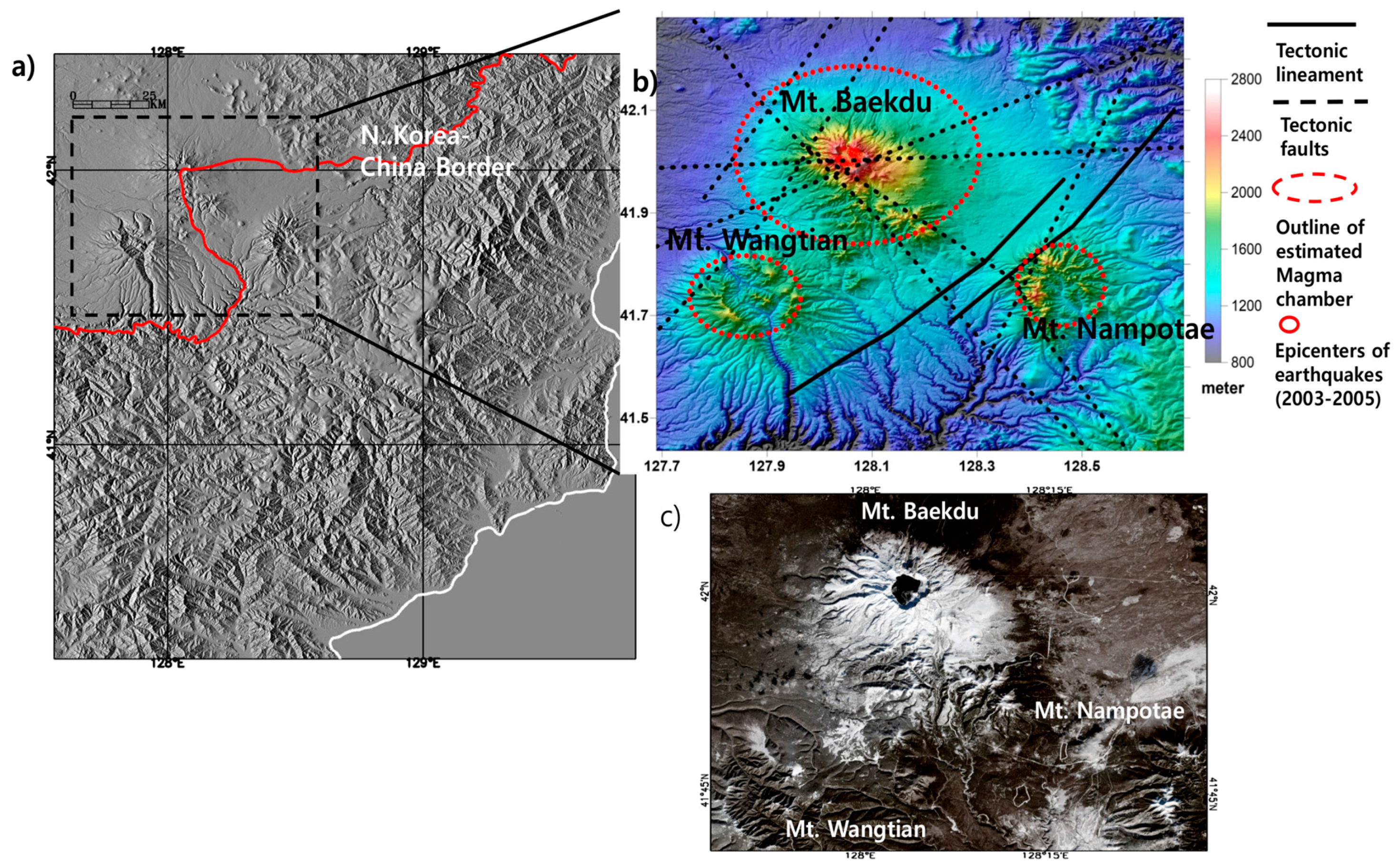
2. Target Area and Relevant SAR Analysis Issues
3. Processing Strategy and Data Sets
3.1. Two Pass DInSAR with Atmospheric Error Compensation
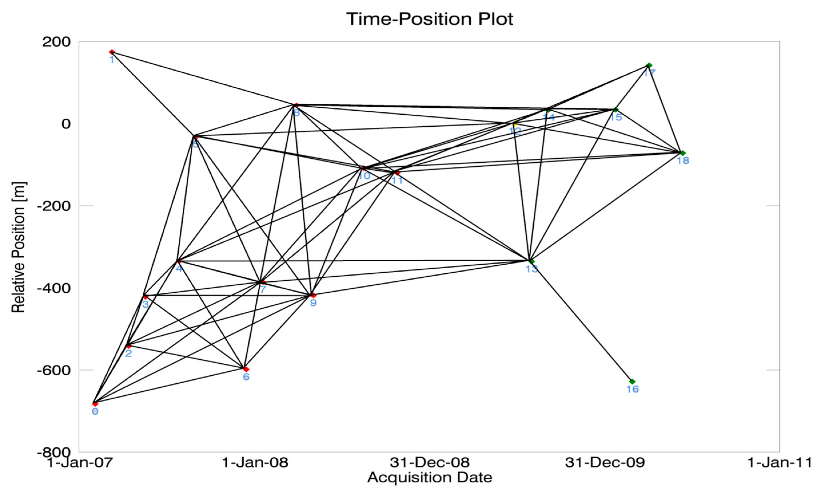
3.2. Time Series Analysis with StaMPS/MTI Approach
3.3. Data Sets
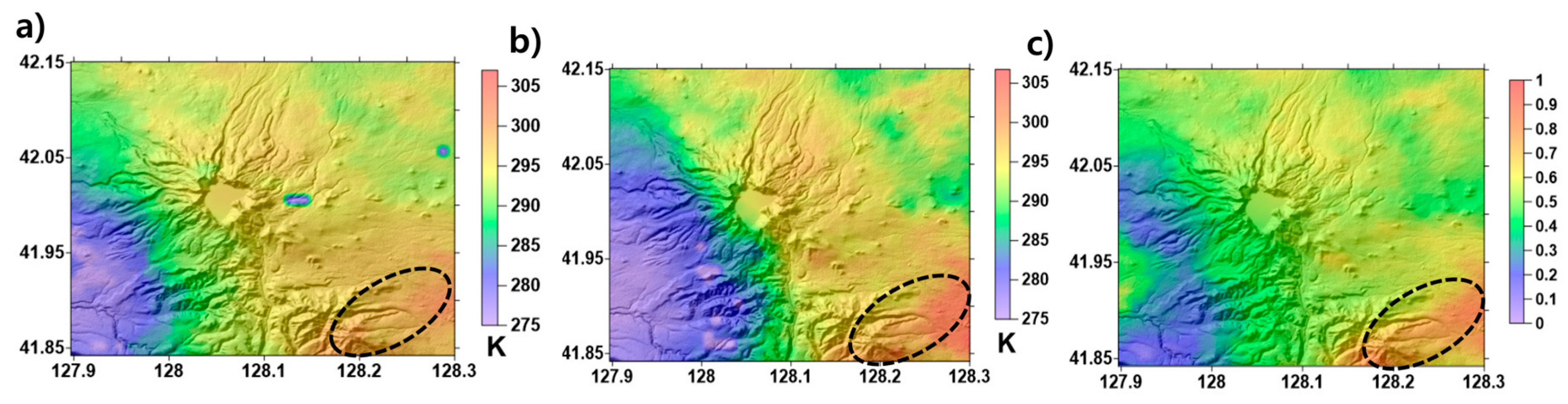
3.4. WRF Model Processing
4. Processing Results
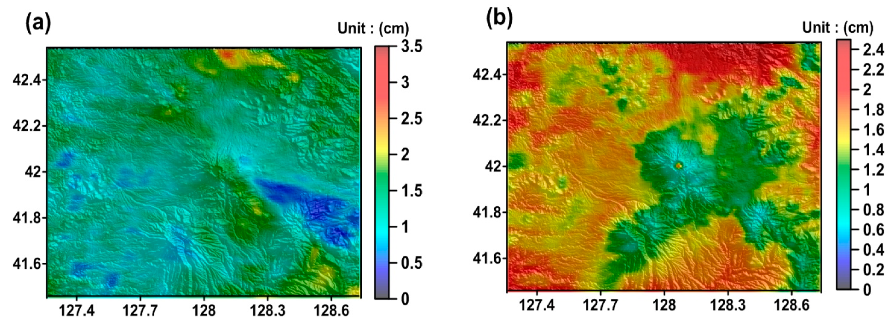
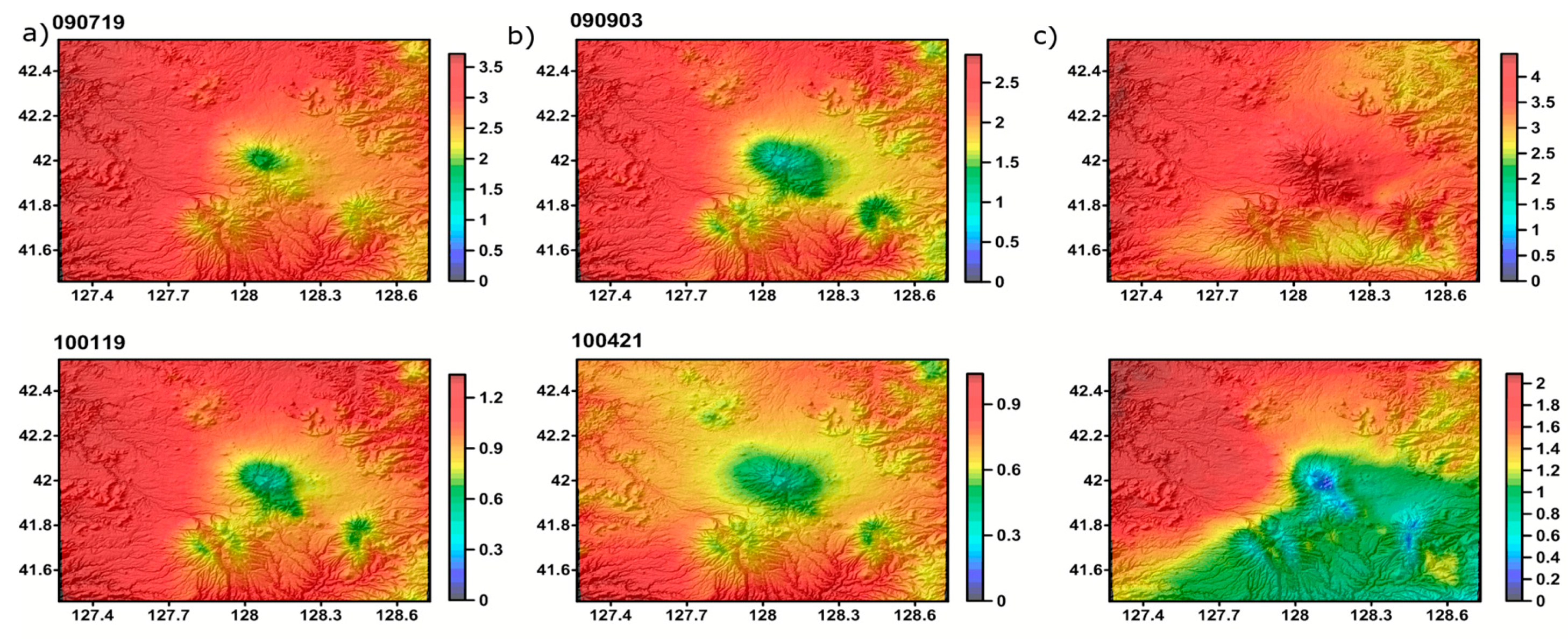
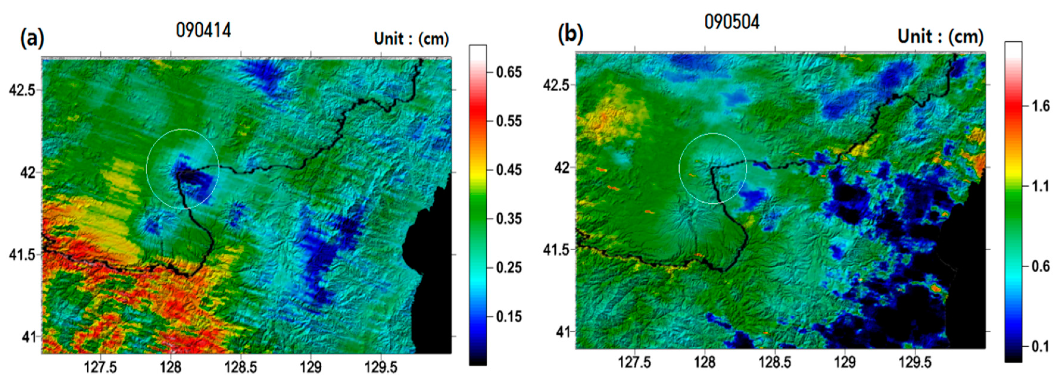
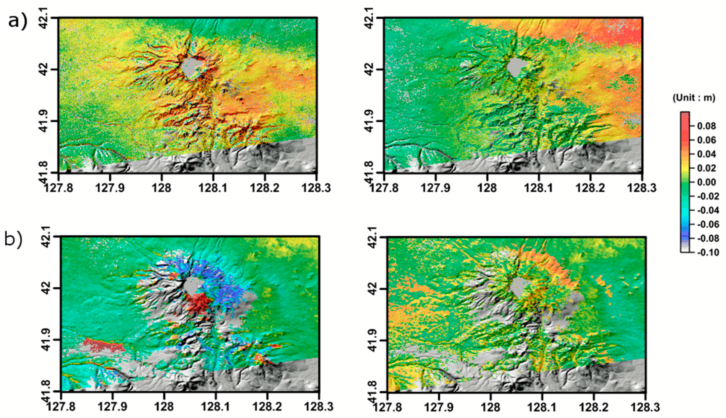
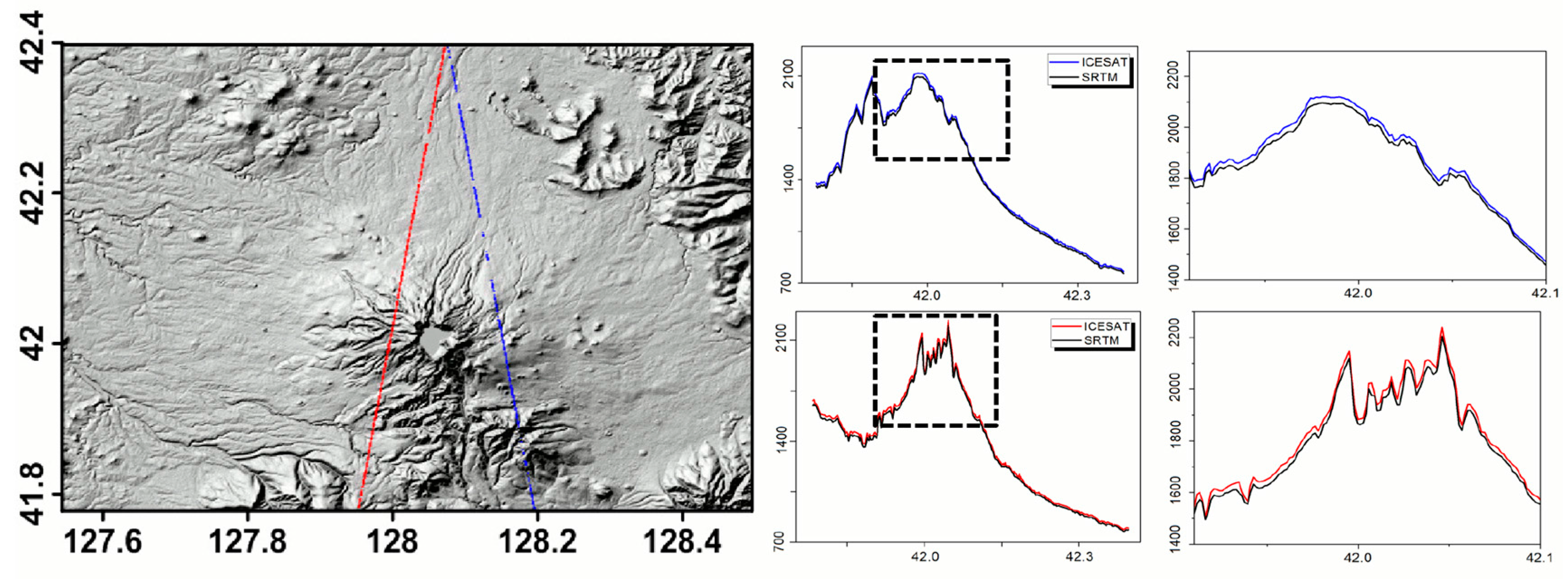
4.1. Validation of the Atmospheric Error Model and Two Pass DInSAR Analyses Using ALOS PALSAR
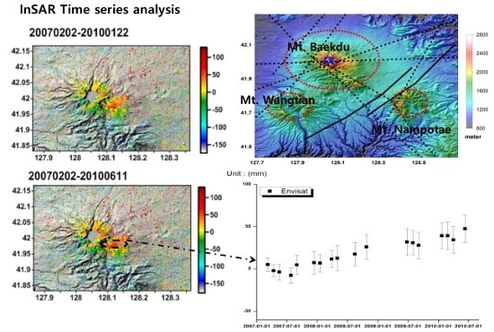
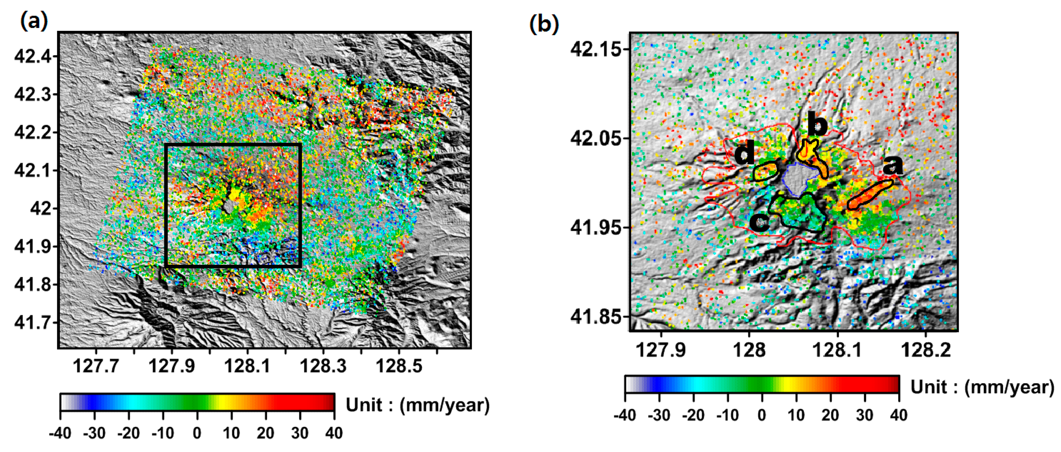
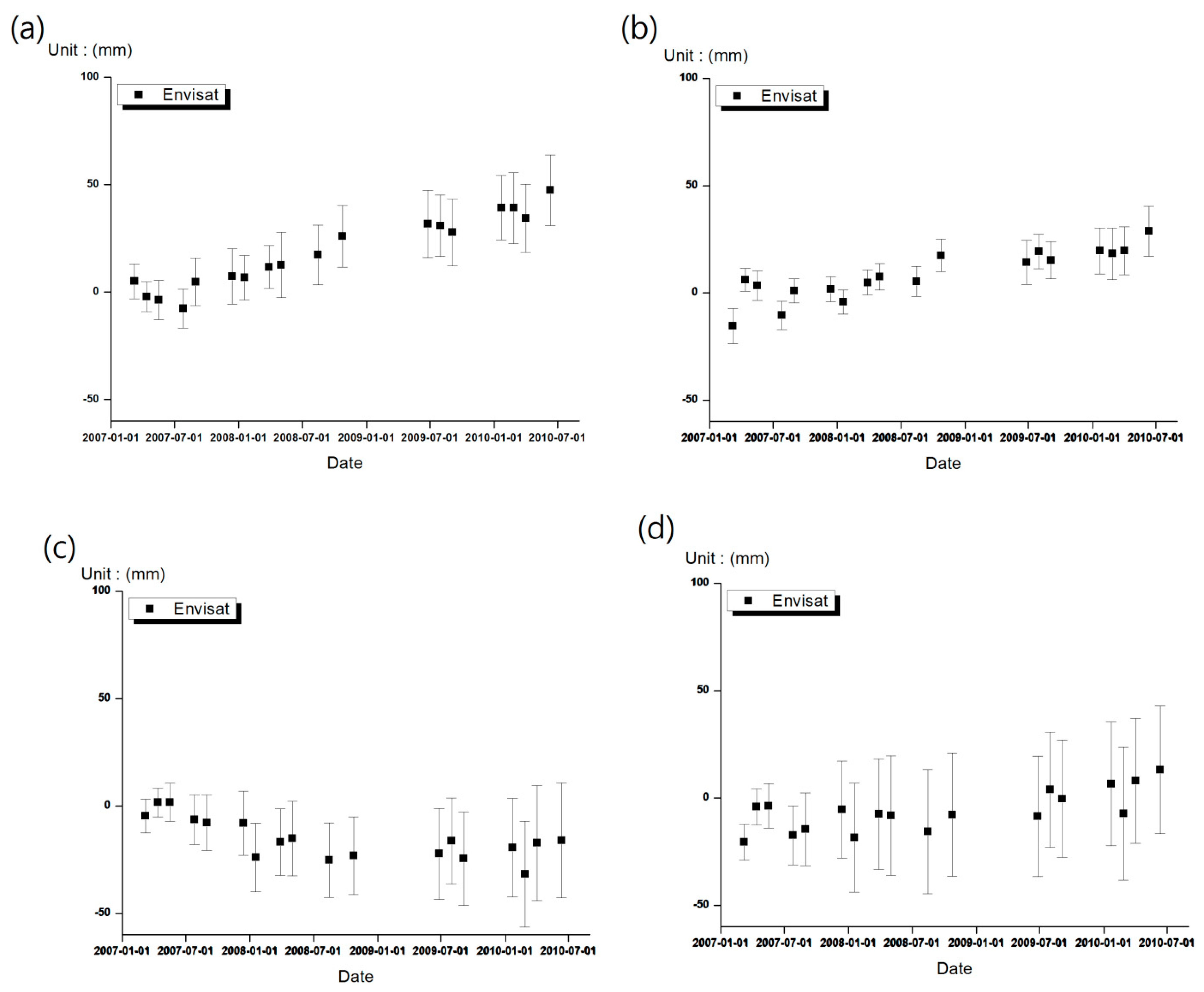
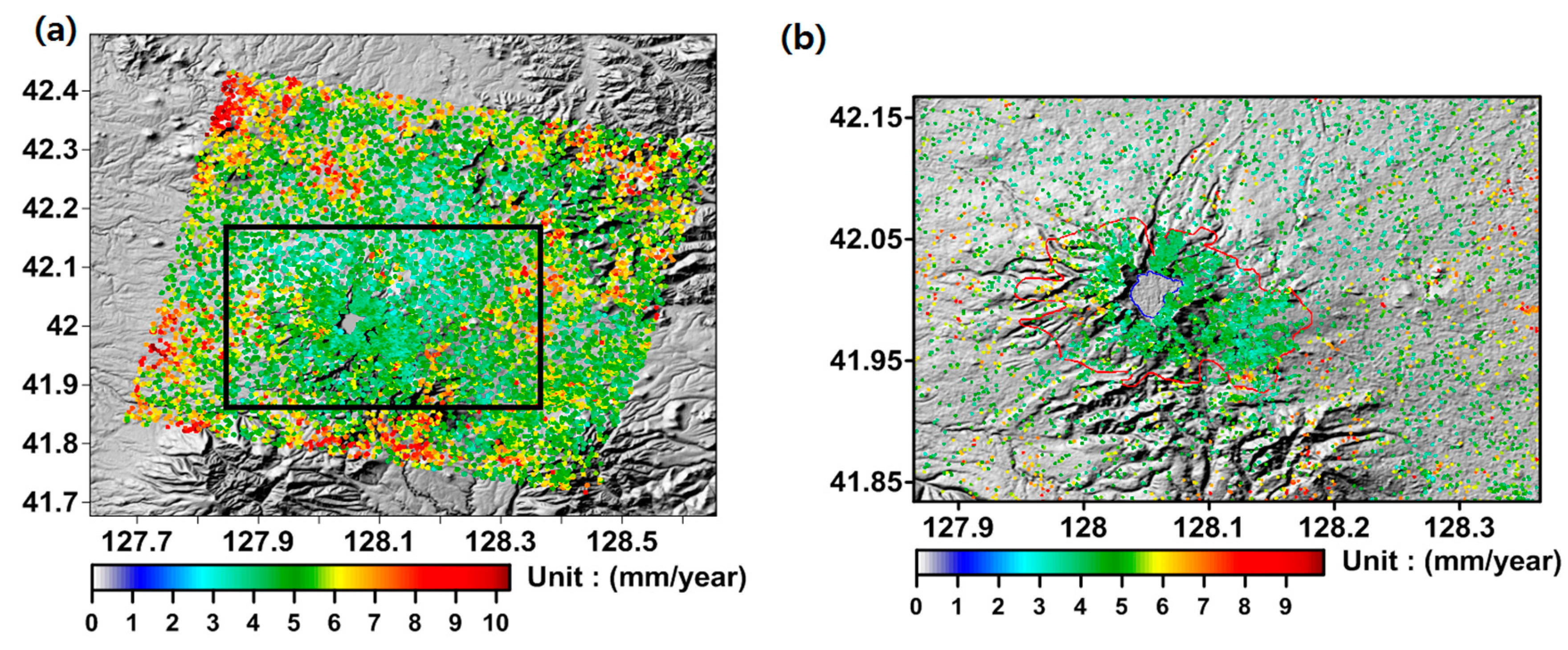
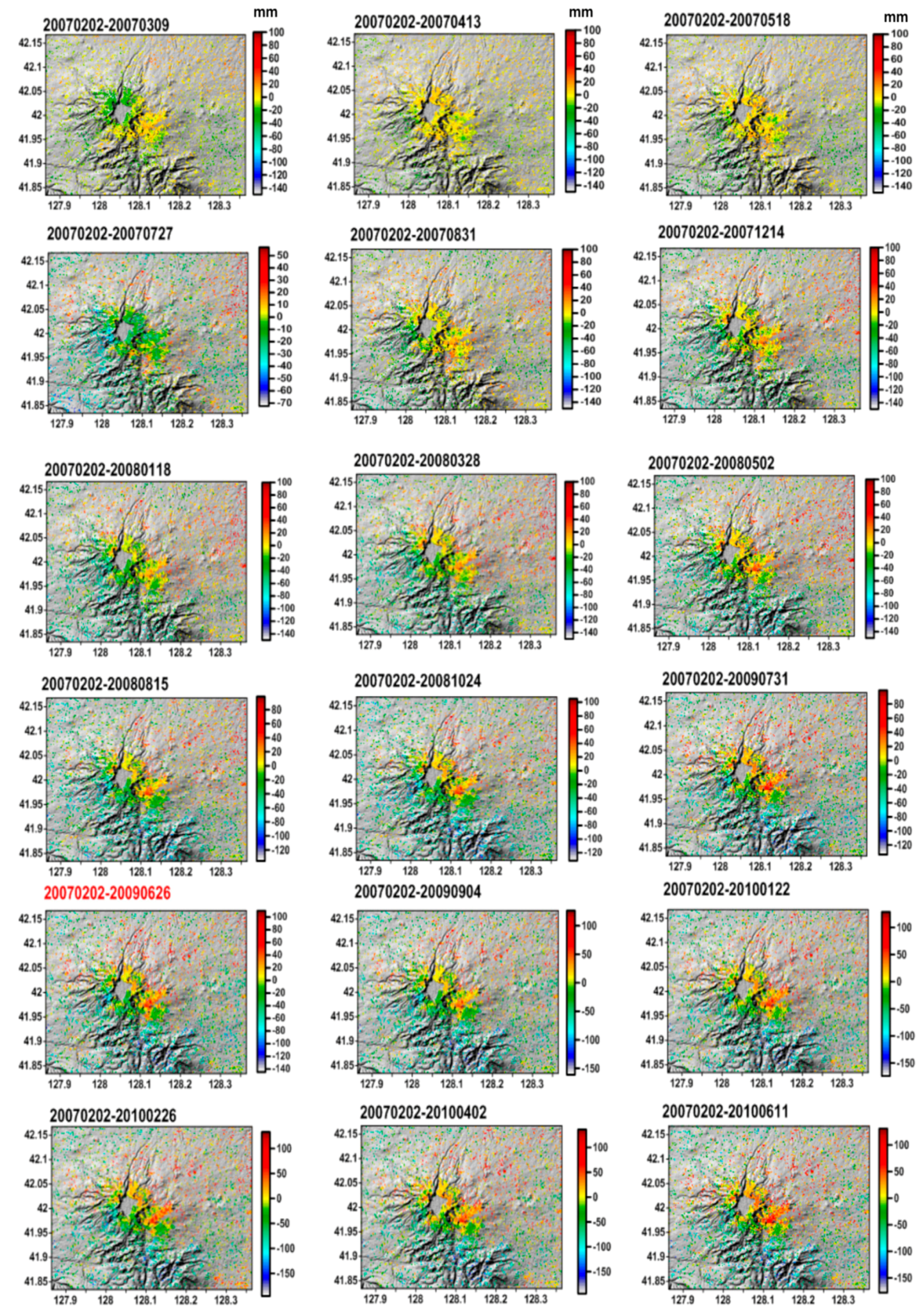
4.2. Time Series Analysis with ENVISAT ASAR
5. Discussion
5.1. DInSAR Performance
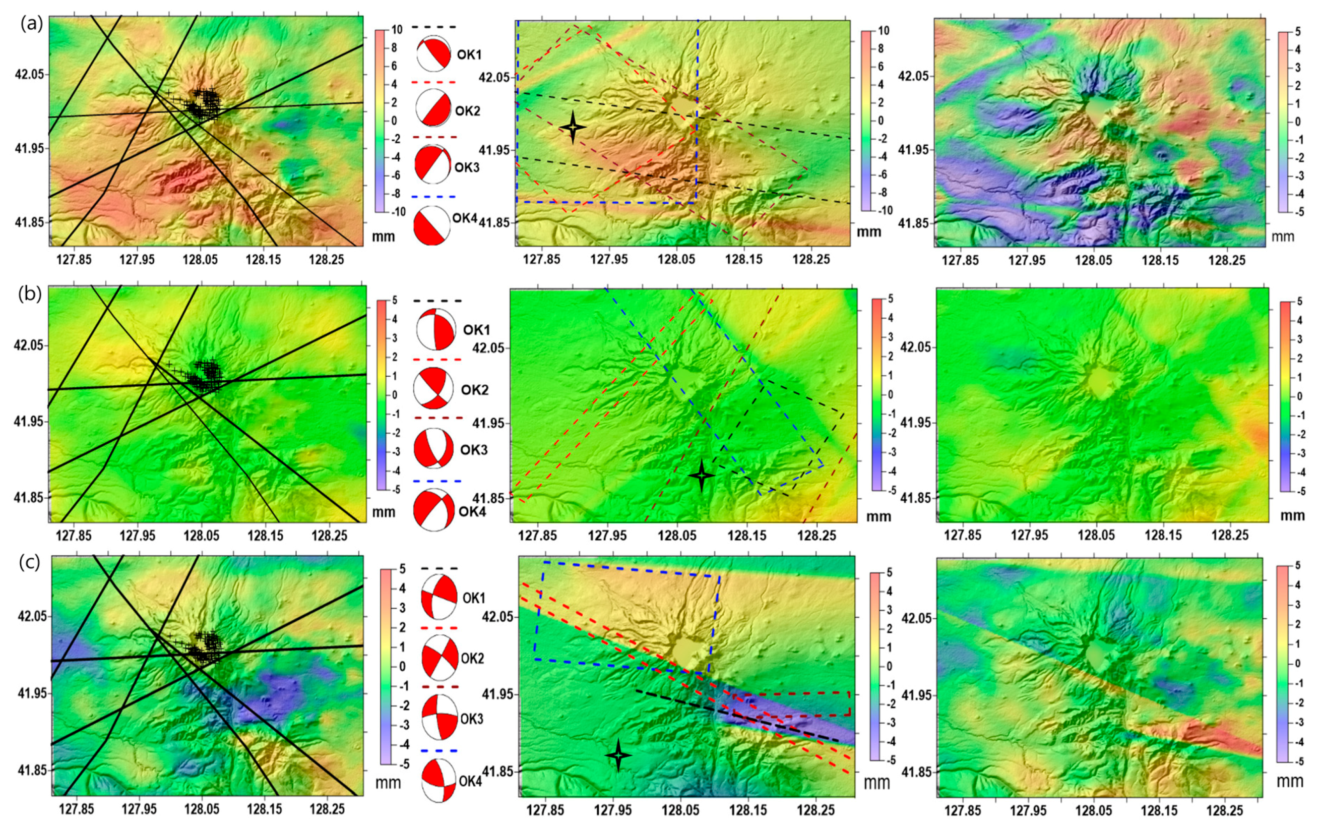
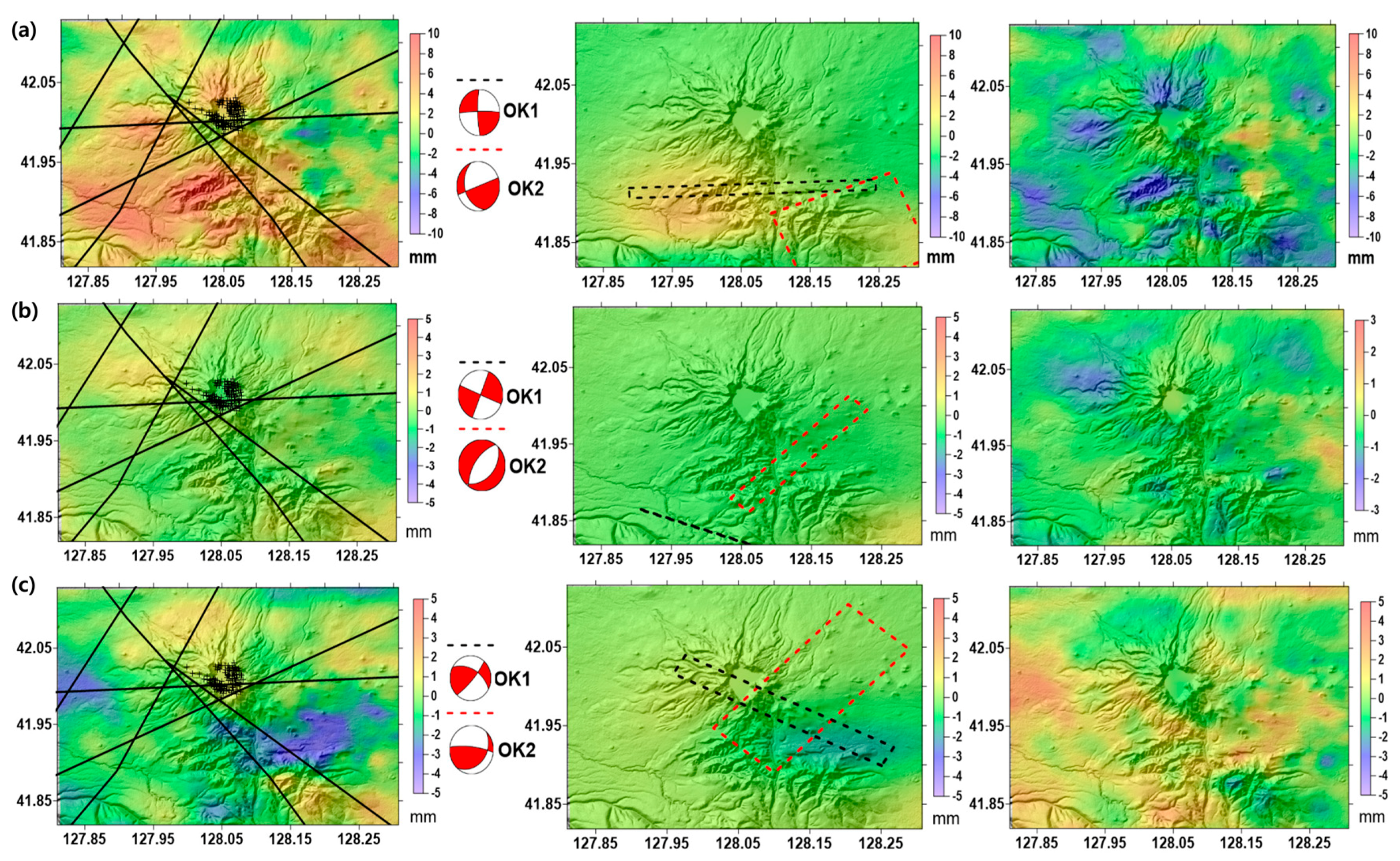
5.2. Interpretation of StaMPS/MTI Processing Results
6. Conclusions and Future Work
Acknowledgments
Author Contributions
Conflicts of Interest
References
- Gao, Q. Volcanic hydrothermal activities and gas-releasing characteristics of the Tianchi lake region, Changbai mountains. Acta Geosci. Sin. 2004, 25, 345–350. [Google Scholar]
- Liu, G.; Zhang, H.; Kong, Q. Analysis of the seismic activity at the Changbaishan Tianchi volcano. Seismol. Geol. 2006, 28, 503–508. [Google Scholar]
- Yun, S.H.; Lee, J.H. Analysis of unrest signs of activity at the Baegdusan volcano. J. Petrol. Soc. Korea 2012, 21, 1–12. [Google Scholar] [CrossRef]
- Xu, J.; Liu, G.; Wu, J.; Ming, Y.; Wang, Q.; Cui, D.; Shangguan, Z.; Pan, B.; Lin, X.; Liu, J. Recent unrest of Changbaishan volcano, northeast China: A precursor of a future eruption? Geophys. Res. Lett. 2012, 39, L16305. [Google Scholar] [CrossRef]
- Choi, S.; Oh, C.W.; Götze, H.J. Three-dimensional density modeling of the EGM2008 gravity field over the Mount Paekdu volcanic area. J. Geophys. Res. Solid Earth 2013, 118, 3820–3836. [Google Scholar] [CrossRef]
- Zebker, H.A.; Goldstein, R.M. Topographic mapping from interferometric SAR observations. J. Geophys. Res. Solid Earth 1986, 91, 4993–4999. [Google Scholar] [CrossRef]
- Massonnet, D.; Briole, P.; Arnaud, A. Deflation of Mount Etna monitored by spaceborne radar interferometry. Nature 1995, 375, 567–570. [Google Scholar] [CrossRef]
- Dzurisin, D.; Lisowski, M.; Wicks, C.W.; Poland, M.P.; Endo, E.T. Geodetic observations and modeling of magmatic inflation at the Three Sisters volcanic center, central Oregon Cascade Range, USA. J. Volcanol. Geotherm. Res. 2006, 150, 35–54. [Google Scholar] [CrossRef]
- Borgia, A.; Tizzani, P.; Solaro, G.; Manzo, M.; Casu, F.; Luongo, G.; Pepe, A.; Berardino, P.; Fornaro, G.; Sansosti, E.; et al. Volcanic spreading of Vesuvius, a new paradigm for interpreting its volcanic activity. Geophys. Res. Lett. 2005, 32. [Google Scholar] [CrossRef]
- Brunori, C.A.; Bignami, C.; Stramondo, S.; Bustos, E. 20 years of active deformation on Volcano Caldera: Joint analysis of InSAR and AInSAR techniques. Int. J. Appl. Earth Obs. Geoinf. 2012, 23, 279–287. [Google Scholar] [CrossRef] [Green Version]
- Pinel, V.; Poland, M.P.; Hooper, A. Volcanology: Lessons learned from synthetic aperture radar imagery. J. Volcanol. Geotherm. Res. 2014, 289, 81–113. [Google Scholar] [CrossRef]
- Marra, F.; Gaeta, M.; Giaccio, B.; Jicha, B.R.; Palladino, D.M.; Polcari, M.; Stramondo, S. Assessing the volcanic hazard for Rome: 40Ar/39Ar and In-SAR constraints on the most recent eruptive activity and present-day uplift at Colli Albani Volcanic District. Geophys. Res. Lett. 2016, 43, 6898–6906. [Google Scholar] [CrossRef]
- Meyer, F.J.; McAlpin, D.B.; Gong, W.; Ajadi, O.; Arko, S.; Webley, P.W.; Dehn, J. Integrating SAR and derived products into operational volcano monitoring and decision support systems. ISPRS J. Photogramm. Remote Sens. 2015, 100, 106–117. [Google Scholar] [CrossRef]
- Di Traglia, F.; Nolesini, T.; Intrieri, E.; Mugnai, F.; Leva, D.; Rosi, M.; Casagli, N. Review of ten years of volcano deformation recorded by the ground-based InSAR monitoring system at Stromboli volcano: A tool to mitigate volcano flank dynamics and intense volcanic activity. Earth Sci. Rev. 2014, 139, 317–335. [Google Scholar] [CrossRef]
- Yin, J.; Jull, A.J.; Burr, G.S.; Zheng, Y. A wiggle-match age for the Millennium eruption of Tianchi Volcano at Changbaishan, Northeastern China. Quat. Sci. Rev. 2012, 47, 150–159. [Google Scholar] [CrossRef]
- Newhall, C.G.; Self, S. The volcanic explosivity index (VEI) an estimate of explosive magnitude for historical volcanism. J. Geophys. Res. Ocean. 1982, 87, 1231–1238. [Google Scholar] [CrossRef]
- Yun, S.H.; Cho, E.; Yang, I. Interpretation of historical eruptions of Mt. Baekdu Volcano, Korea. In Proceedings of the AGU Fall Meeting, San Francisco, CA, USA, 15–19 December 2014; Volume 1, p. 4766.
- Eisinger, M.; Burrows, J.P. Tropospheric sulfur dioxide observed by the ERS-2 GOME instrument. Geophys. Res. Lett. 1998, 25, 4177–4180. [Google Scholar] [CrossRef]
- Vaughan, R.G.; Hook, S.J. Using satellite data to characterize the temporal thermal behavior of an active volcano: Mount St. Helens, WA. Geophys. Res. Lett. 2006, 33, 867–873. [Google Scholar] [CrossRef]
- Leprince, S.; Barbot, S.; Ayoub, F.; Avouac, J.P. Automatic and precise orthorectification, coregistration, and subpixel correlation of satellite images, application to ground deformation measurements. IEEE Trans. Geosci. Remote Sens. 2007, 45, 1529–1558. [Google Scholar] [CrossRef]
- Kim, S.W.; Won, J.S.; Kim, J.W.; Moon, W.M.; Min, K.D. Multi temporal JERS-1 SAR investigation of Mt. Baekdu stratovolcano using differential interferometry. Geosci. J. 2001, 5, 301–312. [Google Scholar] [CrossRef]
- Kim, J.R.; Lin, S.Y.; Hong, S.; Choi, Y.S.; Yun, H.W. Ground deformation tracking over Mt. Baekdu: A pre-evaluation of possible magma recharge by D-InSAR analysis. KSCE J. Civ. Eng. 2014, 18, 1505–1510. [Google Scholar] [CrossRef]
- Lee, H.; Liu, J.G. Analysis of topographic decorrelation in SAR interferometry using ratio coherence imagery. IEEE Trans. Geosci. Remote Sens. 2001, 39, 223–232. [Google Scholar]
- Parker, A.L.; Biggs, J.; Walters, R.J.; Ebmeier, S.K.; Wright, T.J.; Teanby, N.A.; Lu, Z. Systematic assessment of atmospheric uncertainties for InSAR data at volcanic arcs using large-scale atmospheric models: Application to the Cascade volcanoes, United States. Remote Sens. Environ. 2015, 170, 102–114. [Google Scholar] [CrossRef]
- Remy, D.; Chen, Y.; Froger, J.L.; Bonvalot, S.; Cordoba, L.; Fustos, J. Revised interpretation of recent InSAR signals observed at Llaima volcano (Chile). Geophys. Res. Lett. 2015, 42, 3870–3879. [Google Scholar] [CrossRef]
- Zebker, H.A.; Rosen, P.A.; Hensley, S. Atmospheric effects in interferometric synthetic aperture radar surface deformation and topographic maps. J. Geophys. Res. 1997, 102, 7547–7563. [Google Scholar] [CrossRef]
- Samsonov, S. Topographic correction for ALOS PALSAR interferometry. IEEE Trans. Geosci. Remote Sens. 2010, 48, 3020–3027. [Google Scholar] [CrossRef]
- Hanssen, R.F. Radar Interferometry: Data Interpretation and Error Analysis; Springer: Dordrecht, The Netherlands, 2001; p. 308. [Google Scholar]
- NASA GSFC MODIS Atmosphere H2O Vapor. Available online: http://modis-atmos.gsfc.nasa.gov/MOD05_L2/index.html (accessed on 2 June 2015).
- Li, Z.; Muller, J.P.; Cross, P. Comparison of precipitable water vapor derived from radiosonde, GPS, and Moderate-Resolution Imaging Spectroradiometer measurements. J. Geophys. Res. Atmos. 2003, 108. [Google Scholar] [CrossRef]
- Li, Z.; Muller, J.P.; Cross, P.; Fielding, E.J. Interferometric synthetic aperture radar (InSAR) atmospheric correction: GPS, Moderate Resolution Imaging Spectroradiometer (MODIS), and InSAR integration. J. Geophys. Res. Solid Earth (1978–2012) 2005, 110. [Google Scholar] [CrossRef]
- Li, Z.; Muller, J.P.; Cross, P.; Albert, P.; Fischer, J.; Bennartz, R. Assessment of the potential of MERIS near-infrared water vapor products to correct ASAR interferometric measurements. Int. J. Remote Sens. 2006, 27, 349–365. [Google Scholar] [CrossRef]
- Ferretti, A.; Prati, C.; Rocca, F. Nonlinear subsidence rate estimation using permanent scatterers in differential SAR interferometry. IEEE Trans. Geosci. Remote Sens. 2000, 38, 2202–2212. [Google Scholar] [CrossRef]
- Ferretti, A.; Prati, C.; Rocca, F. Permanent scatterers in SAR interferometry. IEEE Trans. Geosci. Remote Sens. 2001, 39, 8–20. [Google Scholar] [CrossRef]
- Berardino, P.; Fornaro, G.; Lanari, R.; Sansosti, E. A new algorithm for surface deformation monitoring based on small baseline differential SAR interferograms. IEEE Trans. Geosci. Remote Sens. 2002, 40, 2375–2383. [Google Scholar] [CrossRef]
- Colesanti, C.; Ferretti, A.; Novali, F.; Prati, C.; Rocca, F. SAR monitoring of progressive and seasonal ground deformation using the permanent scatterers technique. IEEE Trans. Geosci. Remote Sens. 2003, 41, 1685–1701. [Google Scholar] [CrossRef]
- Saastamoinen, J. Atmospheric correction for the troposphere and stratosphere in radio ranging satellites. Geophys. Monogr. Ser. 1972, 15, 247–251. [Google Scholar]
- Bevis, M.; Businger, S.; Chiswell, S.; Herring, T.A.; Anthes, R.A.; Rocken, C.; Ware, R.H. GPS meteorology: Mapping zenith wet delays onto precipitable water. J. Appl. Meteorol. 1994, 33, 379–386. [Google Scholar] [CrossRef]
- Wadge, G.; Webley, P.W.; James, I.N.; Bingley, R.; Dodson, A.; Waugh, S.; Veneboer, T.; Puglisi, G.; Mattia, M.; Baker, D.; et al. Atmospheric models, GPS and InSAR measurements of the tropospheric water vapor field over Mount Etna. Geophys. Res. Lett. 2002, 29, 1905. [Google Scholar] [CrossRef]
- Foster, J.; Brooks, B.; Cherubini, T.; Shacat, C.; Businger, S.; Werner, C.L. Mitigating atmospheric noise for InSAR using a high resolution weather model. Geophys. Res. Lett. 2006, 33. [Google Scholar] [CrossRef]
- Nico, G.; Tomé, R.; Catalao, J.; Miranda, P.M. On the Use of the WRF model to mitigate tropospheric phase delay effects in SAR interferograms. IEEE Trans. Geosci. Remote Sens. 2011, 49, 4970–4976. [Google Scholar] [CrossRef]
- Hooper, A. A multi-temporal InSAR method incorporating both persistent scatterer and small baseline approaches. Geophys. Res. Lett. 2008, 35. [Google Scholar] [CrossRef]
- Hooper, A.; Zebker, H.; Segall, P.; Kampes, B. A new method for measuring deformation on volcanoes and other natural terrains using InSAR persistent scatterers. Geophys. Res. Lett. 2004, 31. [Google Scholar] [CrossRef]
- Hooper, A.; Segall, P.; Zebker, H. Persistent scatterer interferometric synthetic aperture radar for crustal deformation analysis, with application to Volcán Alcedo, Galápagos. J. Geophys. Res. Solid Earth 2007, 112. [Google Scholar] [CrossRef]
- Pinel, V.; Hooper, A.; De la Cruz-Reyna, S.; Reyes-Davila, G.; Doin, M.P. Study of the deformation field of two active Mexican Strato volcanoes (Popocatepetl and Colima Volcano) by time series of InSAR data. In Fringe Workshop Proceedings; ESA Special Publication: Frascati, Italy, 2008; Volume SP-649, p. 7. [Google Scholar]
- Chang, C.; Yen, J.; Hooper, A.; Chou, F.; Chen, Y.; Hou, C.; Hung, W.; Lin, M. Space-borne Radar for surface deformation analysis of northern Taiwan area, differential and persistent scatterer interferometry. In Proceedings of the AGU Fall Meeting, San Francisco, CA, USA, 15–19 December 2008; Volume 1, p. 1982.
- Decriem, J.; Árnadóttir, T.; Hooper, A.; Geirsson, H.; Sigmundsson, F.; Keiding, M.; Ófeigsson, B.G.; Hreinsdóttir, S.; Einarsson, P.; LaFemina, P.; et al. The 2008 May 29 earthquake doublet in SW Iceland. Geophys. J. Int. 2010, 181, 1128–1146. [Google Scholar] [CrossRef]
- Rosen, P.A.; Hensley, S.; Peltzer, G.; Simons, M. Updated repeat orbit interferometry package released. Eos Trans. Am. Geophys. Union 2004, 85, 47. [Google Scholar] [CrossRef]
- Chen, C.W.; Zebker, H.A. Phase unwrapping for large SAR interferograms: statistical segmentation and generalized network models. IEEE Trans. Geosci. Remote Sens. 2002, 40, 1709–1719. [Google Scholar] [CrossRef]
- Puysségur, B.; Michel, R.; Avouac, J.P. Tropospheric phase delay in interferometric synthetic aperture radar estimated from meteorological model and multispectral imagery. J. Geophys. Res. Solid Earth (1978–2012) 2007, 112. [Google Scholar] [CrossRef]
- Skamarock, W.C.; Klemp, J.B.; Dudhia, J.; Gill, D.O.; Barker, D.M.; Wang, W.; Powers, J.G. A Description of the Advanced Research WRF Version 2 (No. NCAR/TN-468+STR); National Center for Atmospheric Research Boulder Co Mesoscale and Microscale Meteorology Division: Boulder, CO, USA, 2005. [Google Scholar]
- National Centers for Environmental Prediction (NCEP). U.S. National Centers for Environmental Prediction Updated Daily: NCEP FNL Operational Model Global Tropospheric Analyses, Continuing from July 1999; CISL Data Support Section at the National Center for Atmospheric Research: Boulder, CO, USA; Dataset ds083.2. Available online: http://dss.ucar.edu/datasets/ds083.2/ (accessed on 2 June 2013).
- Hong, S.Y.; Noh, Y.; Dudhia, J. A new vertical diffusion package with an explicit treatment of entrainment processes. Mon. Weather Rev. 2006, 134, 2318–2341. [Google Scholar] [CrossRef]
- Mlawer, E.J.; Clough, S.A. On the extension of RRTM to the shortwave region. In Proceedings of the Sixth Atmospheric Measurement (ARM) Science Team Meeting, CONF-9603149, San Antonio, TX, USA, 4–7 March 1996; pp. 223–226.
- Dudhia, J. Numerical study of convection observed during the winter monsoon experiment using a mesoscale two-dimensional model. J. Atmos. Sci. 1989, 46, 3077–3107. [Google Scholar] [CrossRef]
- Paulson, C.A. The mathematical representation of wind speed and temperature profiles in the unstable atmospheric surface layer. J. Appl. Meteorol. 1970, 9, 857–861. [Google Scholar] [CrossRef]
- Dyer, A.J.; Hicks, B.B. Flux-gradient relationships in the constant flux layer. Q. J. R. Meteorol. Soc. 1970, 96, 715–721. [Google Scholar] [CrossRef]
- Webb, E. Profile relationships: The log-linear range, and extension to strong stability. Q. J. R. Meteorol. Soc. 1970, 96, 67–90. [Google Scholar] [CrossRef]
- Ek, M.B.; Mitchell, K.E.; Lin, Y.; Rogers, E.; Grunmann, P.; Koren, V.; Gayno, G.; Tarpley, J.D. Implementation of Noah land surface model advances in the National Centers for Environmental Prediction operational mesoscale Eta model. J. Geophys. Res. Atmos. 2003, 108. [Google Scholar] [CrossRef]
- Hong, S.Y.; Lim, J.O.J. The WRF single-moment 6-class microphysics scheme (WSM6). Asia-Pac. J. Atmos. Sci. 2006, 42, 129–151. [Google Scholar]
- Kain, J.S. The Kain-Fritsch convective parameterization: an update. J. Appl. Meteorol. 2004, 43, 170–181. [Google Scholar] [CrossRef]
- Yun, H.W.; Kim, J.R.; Choi, Y.S. The application of InSAR signature time series for landcover classification. Geoadvanced 2012. [Google Scholar] [CrossRef]
- Trasatti, E.; Casu, F.; Giunchi, C.; Pepe, S.; Solaro, G.; Tagliaventi, S.; Sansosti, E. The 2004–2006 uplift episode at Campi Flegrei caldera (Italy): Constraints from SBAS-DInSAR ENVISAT data and Bayesian source inference. Geophys. Res. Lett. 2008, 35, 521–539. [Google Scholar] [CrossRef]
- Currenti, G.; Solaro, G.; Napoli, R.; Pepe, A.; Bonaccorso, A.; Del Negro, C.; Sansosti, E. Modeling of ALOS and COSMO-SkyMed satellite data at Mt Etna: Implications on relation between seismic activation of the Pernicana fault system and volcanic unrest. Remote Sens. Environ. 2012, 125, 64–72. [Google Scholar] [CrossRef] [Green Version]
- Schutz, B.E.; Zwally, H.J.; Shuman, C.A.; Hancock, D.; DiMarzio, J.P. Overview of the ICESat mission. Geophys. Res. Lett. 2005, 32, 97–116. [Google Scholar] [CrossRef]
- Cao, B.; Wang, G.; Liu, Z. The disaster features of rock avalanche and landslide in Tianchi Lake tourist area of Changbai Mountain. In Proceedings of the 1999 IGCP-425 Meeting at Bonvin Building, Paris, France, 20–22 September 1999.
- Wu, J.; Ming, Y.; Zhang, H. Seismic activity at the Changbaishan Tianchi volcano in the summer of 2002. Chin. J. Geophys. 2005, 48, 621–628. [Google Scholar] [CrossRef]
- Pavlis, N.K.; Holmes, S.A.; Kenyon, S.C.; Factor, J.K. The development and evaluation of the Earth Gravitational Model 2008 (EGM2008). J. Geophys. Res. Solid Earth 2008, 117. [Google Scholar] [CrossRef]
- Mogi, K. Relations between the eruptions of various volcanoes and the deformation of the ground surfaces around them. Bull. Earth Res. Inst. Tokyo 1958, 36, 99–134. [Google Scholar]
- Okada, Y. Surface deformation due to shear and tensile faults in a half-space. Bull. Seismol. Soc. Am. 1985, 75, 1135–1154. [Google Scholar]
- Furuya, M. Localized deformation at Miyakejima volcano based on JERS-1 radar interferometry: 1992–1998. Geophys. Res. Lett. 2004, 31. [Google Scholar] [CrossRef]
- Chen, G.H.; Shan, X.J.; Moon, W.M.; Kim, K.R. A modeling of the magma chamber beneath the Changbai Mountains volcanic area constrained by InSAR and GPS derived deformation. Chin. J. Geophys. 2008, 51, 1085–1092. (In Chinese) [Google Scholar] [CrossRef]
- Chen, Y.L.; Wu, J.C.; Guo, L.Y.; Wang, X.Y.; Tan, H.B.; Shen, C.Y. 3D coseismic deformation inversion of Wenchuan Ms8. 0 earthquake with D-InSAR and the fault movement model. In Proceedings of the Remote Sensing of the Environment: 19th National Symposium on Remote Sensing of China, Xian City, China, 20 October 2014.
- Xu, C.; Xu, B.; Wen, Y.; Liu, Y. Heterogeneous fault mechanisms of the 6 October 2008 MW 6.3 Dangxiong (Tibet) earthquake using interferometric synthetic aperture radar observations. Remote Sens. 2016, 8, 228. [Google Scholar] [CrossRef]
- Marquardt, D.W. An algorithm for least-squares estimation of nonlinear parameters. J. Soc. Ind. Appl. Math. 1963, 11, 431–441. [Google Scholar] [CrossRef]
- Hu, Y.X.; Wang, Q.L.; Cui, D.X. Influence on surface deformation by the three different stress source models in volcano area. Seismol. Res. Northwest China 2005, 21, 32–38. (In Chinese) [Google Scholar]
- Yaseen, M.; Hamm, N.A.; Woldai, T.; Tolpekin, V.A.; Stein, A. Local interpolation of coseismic displacements measured by InSAR. Int. J. Appl. Earth Obs. Geoinf. 2013, 23, 1–17. [Google Scholar] [CrossRef]
- Cheloni, D.; Giuliani, R.; D’Anastasio, E.; Atzori, S.; Walters, R.J.; Bonci, L.; D’Agostino, N.; Mattone, M.; Calcaterra, S.; Gambino, P.; et al. Coseismic and post-seismic slip of the 2009 L’Aquila (central Italy) MW 6.3 earthquake and implications for seismic potential along the Campotosto fault from joint inversion of high-precision levelling, InSAR and GPS data. Tectonophysics 2014, 622, 168–185. [Google Scholar] [CrossRef]
- Feuillet, N.; Cocco, M.; Musumeci, C.; Nostro, C. Stress interaction between seismic and volcanic activity at Mt Etna. Geophys. J. Int. 2006, 164, 697–718. [Google Scholar] [CrossRef]
- Tizzani, P.; Battaglia, M.; Castaldo, R.; Pepe, A.; Zeni, G.; Lanari, R. Magma and fluid migration at Yellowstone Caldera in the last three decades inferred from InSAR, leveling, and gravity measurements. J. Geophys. Res. Solid Earth 2015, 120, 2627–2647. [Google Scholar] [CrossRef]
- Battaglia, M.; Cervelli, P.F.; Murray, J.R. Modeling crustal deformation near active faults and volcanic centers-A catalog of deformation models. In US Geological Survey Technique Methods; USGS: Reston, VA, USA, 2013; p. 96. [Google Scholar]
- Folch, A.; Gottsmann, J. Faults and ground uplift at active calderas. Geol. Soc. Lond. Spec. Publ. 2006, 269, 109–120. [Google Scholar] [CrossRef]
- Yun, S.; Segall, P.; Zebker, H. Constraints on magma chamber geometry at Sierra Negra Volcano, Galápagos Islands, based on InSAR observations. J. Volcanol. Geotherm. Res. 2006, 150, 232–243. [Google Scholar] [CrossRef]
- Manzo, M.; Ricciardi, G.P.; Casu, F.; Ventura, G.; Zeni, G.; Borgström, S.; Berardino, P.; Del Gaudio, C.; Lanari, R. Surface deformation analysis in the Ischia Island (Italy) based on spaceborne radar interferometry. J. Volcanol. Geotherm. Res. 2006, 151, 399–416. [Google Scholar] [CrossRef]
- Todesco, M.; Rutqvist, J.; Chiodini, G.; Pruess, K.; Oldenburg, C.M. Modeling of recent volcanic episodes at Phlegrean Fields (Italy): Geochemical variations and ground deformation. Geothermics 2004, 33, 531–547. [Google Scholar] [CrossRef]
- Chiodini, G.; Todesco, M.; Caliro, S.; Del Gaudio, C.; Macedonio, G.; Russo, M. Magma degassing as a trigger of bradyseismic events: The case of Phlegrean Fields (Italy). Geophys. Res. Lett. 2003, 30. [Google Scholar] [CrossRef]
- Land Surface Temperature and Emissivity 8-Day L3 Global 1km. Available online: https://lpdaac.usgs.gov/dataset_discovery/modis/modis_products_table/mod11a2 (accessed on 2 November 2016).
- Wright, T.J.; Parsons, B.E.; Lu, Z. Toward mapping surface deformation in three dimensions using InSAR. Geophys. Res. Lett. 2004, 31. [Google Scholar] [CrossRef]
- Fialko, Y.; Simons, M.; Agnew, D. The complete (3-D) surface displacement field in the epicentral area of the 1999 Mw7. 1 Hector Mine earthquake, California, from space geodetic observations. Geophys. Res. Lett. 2001, 28, 3063–3066. [Google Scholar] [CrossRef]
- Hu, J.; Li, Z.W.; Sun, Q.; Zhu, J.J.; Ding, X.L. Three-dimensional surface displacements from InSAR and GPS measurements with variance component estimation. IEEE Geosci. Remote Sens. Lett. 2012, 9, 754–758. [Google Scholar]
- Samsonov, S.; van der Kooij, M.; Tiampo, K. A simultaneous inversion for deformation rates and topographic errors of DInSAR data utilizing linear least square inversion technique. Comput. Geosci. 2011, 37, 1083–1091. [Google Scholar] [CrossRef]
- Fattahi, H.; Amelung, F. DEM error correction in InSAR time series. IEEE Trans. Geosci. Remote Sens. 2013, 51, 4249–4259. [Google Scholar] [CrossRef]
- Chun, J.M.; Rang Kim, K.; Lee, S.Y.; Kang, W.S.; Park, J.S.; Yi, C.Y.; Choi, Y.J.; Park, E.W.; Hong, S.S.; Jung, H.S. High Resolution Forecasting System for Mountain area based on KLAPS-WRF. In Proceedings of the EGU General Assembly Conference, Vienna, Austria, 7–2 April 2013; Volume 15, p. 6656.


| Perpendicular Baseline (m) | Image ID | Operation Mode | Acquisition Time | Track | Frame | Polarization | |
|---|---|---|---|---|---|---|---|
| Pair 1 | 562.6 | ALPSRP185620830 | FBD | 2009/07/19 13:53 | 401 | 770 | HH + HV |
| ALPSRP192330830 | FBD | 2009/09/03 13:53 | 401 | 770 | HH + HV | ||
| Pair 2 | 912.1 | ALPSRP212460830 | FBS | 2010/01/19 13:53 | 401 | 770 | HH |
| ALPSRP225880830 | FBS | 2010/04/21 13:53 | 401 | 770 | HH |
| No | Acquisition Time | Orbit | Track | Frame | Pass |
|---|---|---|---|---|---|
| 0 | 2007/02/02 01:44:47.53 | 25751 | 146 | 2759 | Descend |
| 1 | 2007/03/09 01:44:48.84 | 26252 | 146 | 2760 | Descend |
| 2 | 2007/04/13 01:44:47.23 | 26753 | 146 | 2760 | Descend |
| 3 | 2007/05/18 01:44:50.34 | 27254 | 146 | 2760 | Descend |
| 4 | 2007/07/27 01:44:52.77 | 28256 | 146 | 2760 | Descend |
| 5 | 2007/08/31 01:44:51.35 | 28757 | 146 | 2760 | Descend |
| 6 | 2007/12/14 01:44:44.71 | 30260 | 146 | 2759 | Descend |
| 7 | 2008/01/18 01:44:45.79 | 30761 | 146 | 2759 | Descend |
| 8 | 2008/03/28 01:44:46.06 | 31763 | 146 | 2759 | Descend |
| 9 | 2008/05/02 01:44:44.21 | 32264 | 146 | 2759 | Descend |
| 10 | 2008/08/15 01:44:46.07 | 33767 | 146 | 2759 | Descend |
| 11 | 2008/10/24 01:44:44.65 | 34769 | 146 | 2759 | Descend |
| 12 | 2009/06/26 01:44:45.26 | 38276 | 146 | 2760 | Descend |
| 13 | 2009/07/31 01:44:44.86 | 38777 | 146 | 2760 | Descend |
| 14 | 2009/09/04 01:44:43.53 | 39278 | 146 | 2760 | Descend |
| 15 | 2010/01/22 01:44:38.78 | 41282 | 146 | 2759 | Descend |
| 16 | 2010/02/26 01:44:36.34 | 41783 | 146 | 2759 | Descend |
| 17 | 2010/04/02 01:44:36.99 | 42284 | 146 | 2761 | Descend |
| 18 | 2010/06/11 01:44:35.17 | 43286 | 146 | 2761 | Descend |
| Time | 2007/08/31–2007/12/14 | 2008/03/28–2008/05/02 | 2010/02/26–2010/04/02 | |||
|---|---|---|---|---|---|---|
| Sources | Point Source | Point Source | Point Source | |||
| Volume Variation (m3) | 3,755,982.141 | 1,579,134.672 | −1,556,898.017 | |||
| Depth (m) | 11,465.467 | 11,094.183 | 10,013.452 | |||
| East (m) | 40,872.121 | 423,213.874 | 415,155.909 | |||
| North (m) | 4,648,746.096 | 4,635,012.344 | 4,635,640.076 | |||
| Sources | Fault line1 (OK1) | Fault line2 (OK2) | Fault line1 (OK1) | Fault line2 (OK2) | Fault line1 (OK1) | Fault line2 (OK2) |
| Length (m) | 49,637.686 | 20,224.747 | 10,229.789 | 37,199.065 | 25,677.193 | 59,879.098 |
| Width (m) | 10,068.544 | 20,793.347 | 14,943.400 | 3401.966 | 29,832.498 | 7353.123 |
| Depth (m) | 488.956 | 497.956 | 0 | 489.432 | 487.343 | 0 |
| Dip (deg) | 13.657 | 5.087 | 22.558 | 48.276 | 90 | 75.416 |
| Strike (deg) | 280.456 | 51.397 | 299.113 | 37.600 | 106.851 | 302.676 |
| East (m) | 422,950.597 | 409,249.061 | 433,181.514 | 413,386.896 | 428,145.174 | 421,806.633 |
| North (m) | 4,644,922.413 | 4,649,463.430 | 4,642,377.592 | 4,648,702.527 | 4,641,577.194 | 4,647,159.085 |
| Rake (deg) | 50.521 | 100.384 | 32.014 | 168.951 | 139.269 | 178.033 |
| Slip(m) | 0.013 | 0.013 | 0.003 | 0.012 | 0.015 | 0.005 |
| Sources | Fault line3 (OK3) | Fault line4 (OK4) | Fault line3 (OK3) | Fault line4 (OK4) | Fault line3 (OK3) | Fault line4 (OK4) |
| Length (m) | 36,275.330 | 44,430.801 | 59,398.234 | 59,989.433 | 14,173.725 | 21,509.433 |
| Width (m) | 13,861.336 | 22,048.059 | 19,446.234 | 9758.042 | 10,852.916 | 27,445.590 |
| Depth (m) | 459.564 | 0.122 | 459.212 | 496.309 | 487.209 | 458.321 |
| Dip (deg) | 8.353 | 0 | 28.343 | 27.852 | 72.539 | 59.372 |
| Strike (deg) | 308.203 | 181.137 | 26.061 | 329.567 | 268.354 | 96.573 |
| East (m) | 418,759.992 | 412,945.360 | 431,978.382 | 419,622.734 | 434,841.328 | 414,725.131 |
| North (m) | 4,647,442.745 | 4,659,005.640 | 4,641,027.366 | 4,661,893.434 | 4,643,033.184 | 4,655,743.219 |
| Rake (deg) | −180 | 134.407 | −42.816 | −159.692 | 19.094 | 34.943 |
| Slip (m) | 0.010 | 0.006 | 0.003 | 0.008 | 0.024 | 0.004 |
| Goodness of fit | NRMSE: 0.029 | NRMSE: 0.119 | NRMSE: 0.015 | |||
| χ2: 0.588 | χ2: 0.372 | χ2: 0.034 | ||||
| RMSE: 2.069 | RMSE: 0.815 | RMSE: 0.971 | ||||
| Time | 2007/08/31–2007/12/14 | 2008/03/28–2008/05/02 | 2010/02/26–2010/04/02 | |||
|---|---|---|---|---|---|---|
| Sources | Fault line1 (OK1) | Fault line2 (OK2) | Fault line1 (OK1) | Fault line2 (OK2) | Fault line1 (OK1) | Fault line2 (OK2) |
| Length(m) | 26,854.218 | 12,738.540 | 21,471.381 | 20,381.859 | 27,459.677 | 23,449.507 |
| Width(m) | 14,210.866 | 17,033.613 | 5124.012 | 3589.145 | 4,253.371 | 10,298.3151 |
| Depth(m) | 3916.382 | 1647.755 | 4987.521 | 1202.627 | 2582.480 | 4933.270 |
| Dip(deg) | 84.0553 | 25.8303 | 89.2013 | 34.6678 | 45.8336 | 22.7832 |
| Strike(deg) | 269.253 | 160.596 | 111.947 | 43.991 | 298.860 | 42.389 |
| East(m) | 421,214.302 | 434,197.853 | 419,186.531 | 428,028.4981 | 426,536.008 | 429,767.141 |
| North(m) | 4,641,029.602 | 4,634,698.001 | 4,631,301.914 | 4,643,152.040 | 4,646,755.059 | 4,649,816.136 |
| Rake(deg) | 10.428 | −179.512 | −179.522 | −82.732 | 161.645 | 38.525 |
| Slip(m) | 0.090 | 0.0268 | 0.0390 | 0.0120 | 0.0505 | 0.0159 |
| Goodness of fit | NRMSE: 0.024 | NRMSE: 0.021 | NRMSE: 0.027 | |||
| χ2: 1.937 | χ2: 1.266 | χ2: 1.067 | ||||
| RMSE: 2.700 | RMSE: 0.501 | RMSE: 1.094 | ||||
© 2017 by the authors. Licensee MDPI, Basel, Switzerland. This article is an open access article distributed under the terms and conditions of the Creative Commons Attribution (CC BY) license ( http://creativecommons.org/licenses/by/4.0/).
Share and Cite
Kim, J.-R.; Lin, S.-Y.; Yun, H.-W.; Tsai, Y.-L.; Seo, H.-J.; Hong, S.; Choi, Y. Investigation of Potential Volcanic Risk from Mt. Baekdu by DInSAR Time Series Analysis and Atmospheric Correction. Remote Sens. 2017, 9, 138. https://doi.org/10.3390/rs9020138
Kim J-R, Lin S-Y, Yun H-W, Tsai Y-L, Seo H-J, Hong S, Choi Y. Investigation of Potential Volcanic Risk from Mt. Baekdu by DInSAR Time Series Analysis and Atmospheric Correction. Remote Sensing. 2017; 9(2):138. https://doi.org/10.3390/rs9020138
Chicago/Turabian StyleKim, Jung-Rack, Shih-Yuan Lin, Hye-Won Yun, Ya-Lun Tsai, Hwa-Jung Seo, Sungwook Hong, and YunSoo Choi. 2017. "Investigation of Potential Volcanic Risk from Mt. Baekdu by DInSAR Time Series Analysis and Atmospheric Correction" Remote Sensing 9, no. 2: 138. https://doi.org/10.3390/rs9020138
APA StyleKim, J.-R., Lin, S.-Y., Yun, H.-W., Tsai, Y.-L., Seo, H.-J., Hong, S., & Choi, Y. (2017). Investigation of Potential Volcanic Risk from Mt. Baekdu by DInSAR Time Series Analysis and Atmospheric Correction. Remote Sensing, 9(2), 138. https://doi.org/10.3390/rs9020138