1. Introduction
Exotic conifers are the foundation of the plantation forest industry in many Southern Hemisphere countries, providing significant economic and social benefits. However, a number of exotic conifer species have become invasive and, under certain environmental settings, propagate beyond the plantation boundary and are now serious tree weeds [
1,
2,
3]. In New Zealand, invasive conifers, often referred to as ‘wilding conifers’, are dominantly invading indigenous and semi-native grass and shrublands across large areas of the South and North Island [
3,
4]. Recent estimates place the total area affected in New Zealand at 1.7 M ha, with the rate of spread estimated at 5%–6% per annum [
5]. Invasive conifers are estimated to occupy, with highly variable densities (from less than one tree per hectare to full cover), an area equivalent to the national plantation forest estate [
5]. The costs from lost pasture land alone are estimated at between $88 and $221 million [
6]. A range of chemical and physical control methods can be deployed to control invasive conifers [
7], but these depend on successful detection of individuals and characterisation of the infestation level to be deployed cost effectively. Extensive closed canopy stands of mature invasive conifers are relatively easy to detect across the landscape, although smaller groups and isolated individuals of various sizes and particularly juvenile and stunted trees are more problematic. The control of early invasion stages, characterised by smaller, juvenile and more scattered trees, is the most cost-effective way to prevent further expansion of conifer infestations [
4,
8]. The detection of such trees is critical for invasive conifer management, even if the detection of individuals at such an early stage of invasion is a complex and laborious task [
9,
10]. Importantly, effective control in these early stages of invasion supported by a high detection rate of mature trees can reduce the cost and intensity of later management efforts on a site as widely-scattered seed producers are eliminated [
8,
11]. Current methods of surveillance and monitoring rely on the detection of invasive conifers across often wide areas carried out as helicopter-based surveys by skilled observers [
12], ground surveys in smaller areas or a combination of both [
13] with often various levels of detection success. These approaches are expensive, even if combined with control operations at the same time (search and destroy), and rely heavily on the observers’ ability to correctly and rapidly identify individual invasive conifers of variable size occurring at various densities across often multiple vegetation types.
Remote sensing has been widely used to detect and monitor invasive species across natural environments ranging from arid areas [
14] and estuaries [
15] to dense tropical rain forests [
16] and coastal scrub communities [
17]. The success of remote sensing techniques has been noted to vary according to the structural and phenological traits of the invasive species in relation to the invaded habitat [
18]. Spectral and other properties from imagery alone can be used to successfully identify invasive species [
18].
Airborne laser scanning (ALS) offers the appealing advantage of providing precise elevation and structural data from vegetation returns, which makes it well suited to the detection of taller isolated trees in otherwise short-stature vegetation types [
19,
20], and the combination of height and structural information derived from LiDAR data with imagery has been shown to improve the identification of invasive species [
21,
22]. The literature on identifying invasive conifers in New Zealand’s unique environment using remote sensing techniques is not well developed, and we are unaware of efforts to use ALS for invasive conifer detection in this context. However, relevant examples of this approach may be found in efforts to detect and monitor shifts in the tree line in boreal ecotones affected by climate change [
23,
24]. Height information from high-density ALS (7.7 pls/m
2) has been successfully used to identify isolated small-stature trees in tundra environments, with nearly 91% of trees >1 m successfully detected according to elevation of echoes above a digital terrain model (DTM) generated from the same data [
19]. Detection of smaller trees was more difficult, with trees <1 m returning discernible positive elevation values 5%–73% of the time depending on species and DTM properties. The decrease in accuracy could be partly attributed to the inherent vertical error in ALS elevation values, the fact that smaller individuals are less likely to be sampled or generate sufficient return energy and an increase in terrain features, such as rocks with a height close to that of the target trees [
19]. Use of additional ALS-derived variables, such as intensity and topographic features, have been proposed as a means of improving the classification of trees and returns from other sources, especially at lower height thresholds [
24,
25]. In one study, the inclusion of intensity and slope with echo elevation allowed tree and non-tree echoes to be distinguished with an accuracy of 93%, and detection was high for nearly all tested models that included elevation and intensity [
25]. However, other studies have found intensity data to be of little use in identifying ground vegetation [
26]. This was at least in part due to the uncalibrated and sensor-dependent nature of intensity information from ALS data, which can reduce the applicability and utility of these data across surveys [
26]. Echo-based classification requires substantial computational power to evaluate datasets over large areas that invariably contain millions of records. Stumberg et al. [
25] explored the use of an unsupervised classification approach using a raster-based algorithm to identify pixels containing trees. Detection of trees using this approach was generally good with detection rates for larger trees (>1 m) ranging from 36%–73%. Overall, larger trees had an increased probability of detection and resulted in reduced errors of commission.
Research on the effect of ALS pulse density would ideally use data acquired from campaigns with varying altitude, speed or pulse frequency. Repeated campaigns would capture both changes in final pulse density, as well as related impacts, such as changes arising from beam divergence or altered energy per pulse [
27,
28,
29,
30]. Unfortunately, this is prohibitively expensive in most cases, and so, researchers have developed methods to thin ALS data and simulate adjusted flight patterns. Numerous studies have investigated the effect of pulse density on forest properties estimated from ALS data [
30,
31,
32,
33]. These studies have encompassed a wide range of forest types and data thinning methods [
29,
34]. However, the impact of pulse density on the detection of small, pioneer trees has not been well studied through simulation or campaign selection. Næsset and Nelson [
19] achieved good detection of isolated trees with ALS data containing 7.7 pls/m
2. At this density, nearly every tree over 1 m was sampled by at least one pulse. Indeed, several other studies have used similar pulse densities in the range of 6–8.5 pls/m
2 [
20,
25,
35] to achieve good rates of detection for similarly-sized trees (>1 m). Detection of pioneer trees at the boundary of the Arctic-boreal regions has been achieved from surveys with densities as low as 0.25 pls/m
2; however, in this case, the trees had a modal height of 6.6 m [
23]. Næsset and Nelson [
19] used data on detection success and tree crown diameter to estimate the size of crowns required for detection at different pulse densities. Their estimate suggested that at 1 pls/m
2, the crown diameter would need to be 2.8–3.3 m to ensure detection. Overall, work in the boreal ecotone has demonstrated that individual pioneer trees in relatively open areas can be accurately detected using LiDAR, potentially over very large areas. In general, trees smaller than 1 m are problematic to detect without increasing the rate of false detections and other sources of error [
19,
20,
25].
Remote sensing-based detection approaches of invasive trees that rely principally on the height of ALS echoes are likely to be well suited to many low stature vegetation types that are susceptible to conifer infestations in New Zealand. Particularly in short-stature grasslands, problematic invasive conifers are able to establish more successfully than most native tree species [
8], simplifying the task of detection and avoiding a high commission error. Other vegetation types highly susceptible to conifer invasions in New Zealand, such as indigenous shrublands or tall tussock grasslands [
36] mixed with complex terrain, pose a much greater challenge to detection efforts.
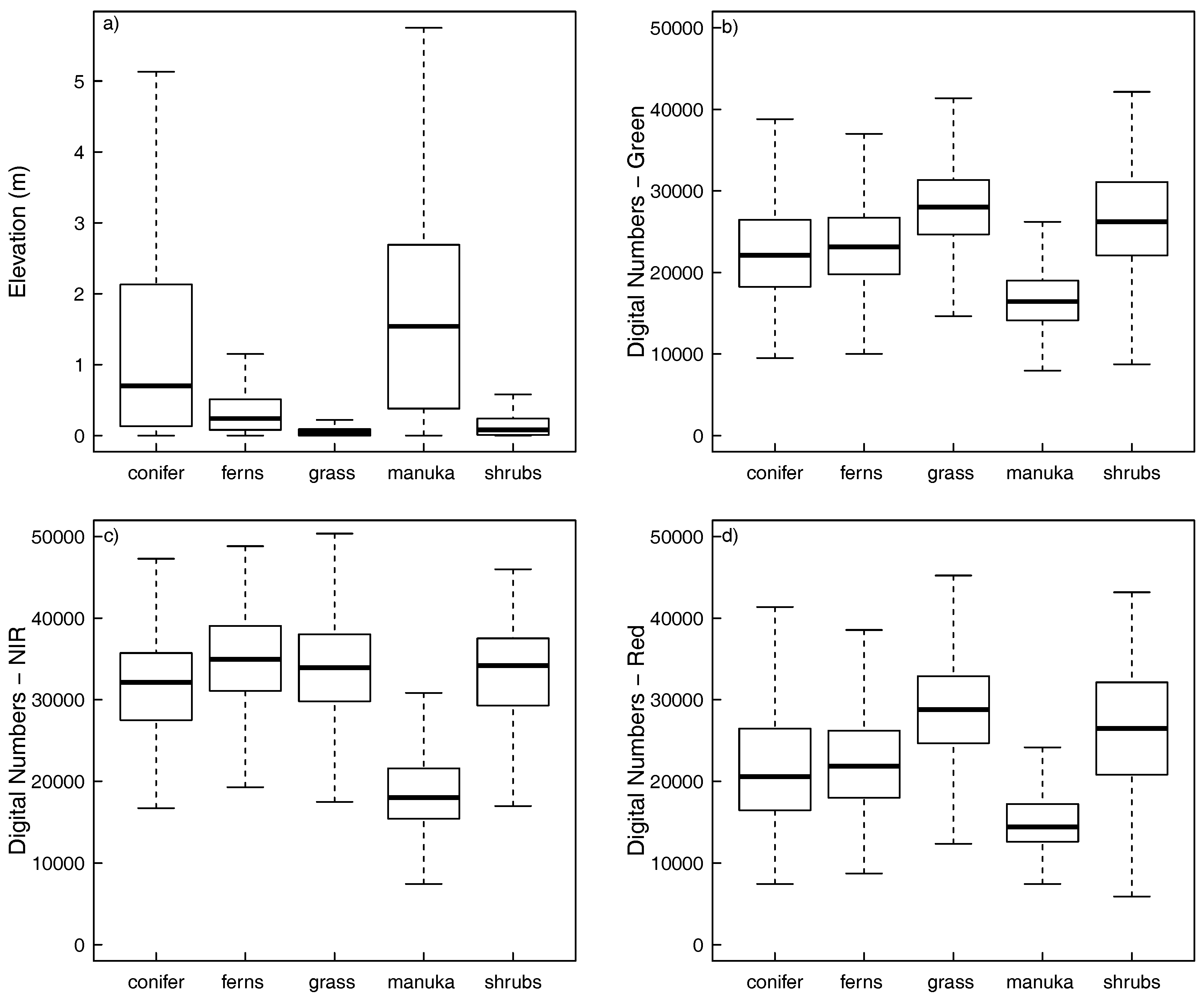
Our study area contained numerous vegetation types and, in some areas, the dominant indigenous vegetation formed closed canopy stands up to 4 m in height. A successful method for classifying invasive conifers requires the capacity to differentiate between echoes from invasive conifers and other vegetation. The ALS data alone may not contain sufficient information for this purpose. Fortunately, the spectral properties of invasive conifers are quite different to those of the other surrounding tree vegetation in this environment. This means that spectral information from aerial imagery may provide a practical means of separating invasive conifers from other vegetation types. Previous studies, working at a coarser resolution, have found that fusing structural information from ALS data with spectral data from satellite imagery provides a useful method for vegetation classification [
37,
38].
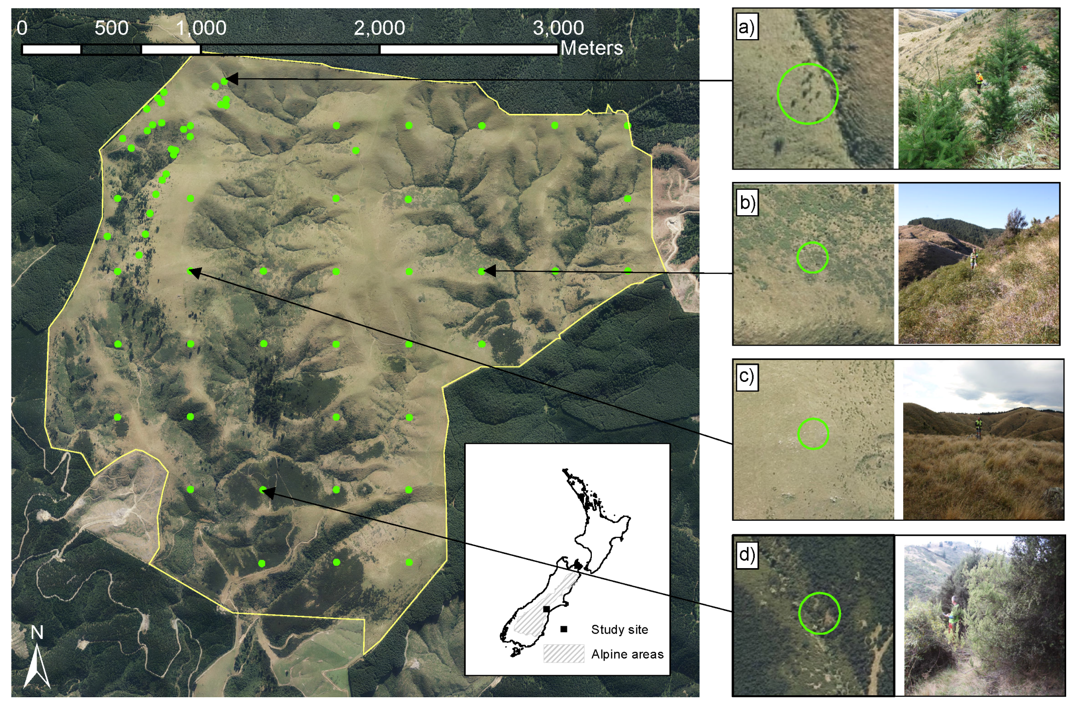
Controlling the spread of invasive conifers is critical to protection of New Zealand’s natural heritage, threatened ecosystems and ecosystem services and maintaining the licence to operate for plantation forest managers in the face of increasing environmental scrutiny. There is a need to develop feasible and effective detection methods to understand and monitor the spread of invasive conifers and to guide management and control efforts of infested areas. In this study, we attempt to develop a method for invasive conifer detection using an extensive dataset that included ALS and spectral data collected from an area dominated by indigenous and semi-native grass and shrublands in New Zealand and a field dataset that sampled 825 solitary conifers of various sizes.
Using this dataset, the objectives of this research were to (i) compare the accuracy of detection models developed using various combinations of ALS data (elevation, intensity) and aerially-acquired spectral data and (ii) determine the sensitivity of classification accuracy in these models to the height threshold used for inclusion and the density of the ALS data.
4. Discussion
The principle finding of this study is that using data from ALS in combination with spectral data from aerial imagery provides a fairly accurate means of classifying LiDAR echoes from invasive conifers in an invasion-prone vegetation type. The study results indicate that this approach may offer a promising method for detecting invasive conifers that invade relatively complex terrain with a vegetation structure composed of short tussock grassland intermixed with shrub species.
The ALS elevation and intensity data and the spectral data from aerial imagery were of limited value for detecting returns from invasive conifers in their own right. Fusion of the two data types improved echo classification. Related approaches relying on ALS elevation data are often concerned only with identifying all tree species in the landscape [
19,
20,
26]. Numerous studies have fused ALS data with spectral data to improve classification [
38,
62]. However, these approaches often rely on pixel-based methods to classify different species [
63,
64] or the aggregation of remote sensing data sources to larger scales, e.g., individual tree crowns [
62]. To the best of our knowledge, this is the first time that spectral data have instead been added to individual ALS echo data to assist with the identification of invasive conifers. This method appears to improve classification accuracy. Although we did not test alternative methods, the removal of the aggregation step may offer some advantages over approaches relying on the aggregation of LiDAR data into surfaces. Of the spectral bands available, the near-infrared band was the most important for detecting invasive conifers in combination with ALS data.
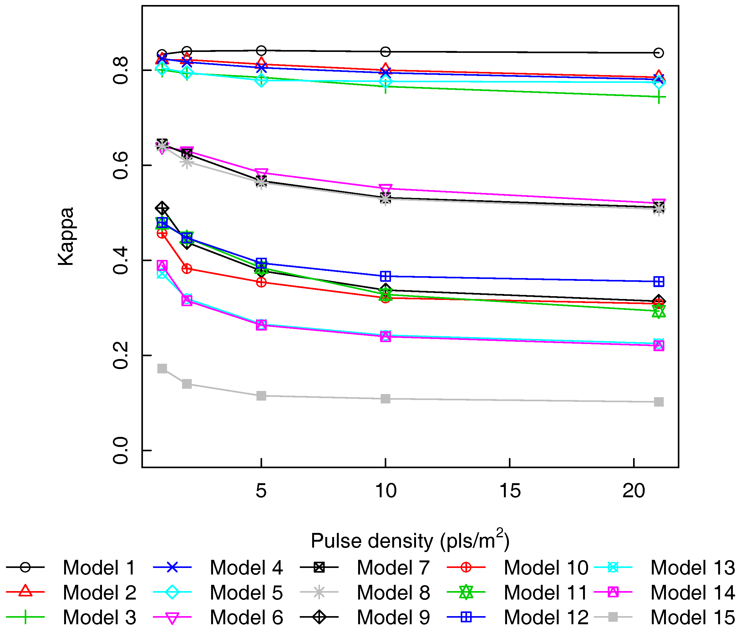
The effect of pulse density on classification accuracy was examined and found to have a negligible effect for the five most accurate models, but the number of missed invasive conifers was highly dependent on the pulse density (increasing the probability of omission). Raising the height threshold for the inclusion of echoes in the training dataset was found to have little impact on four- and five-variable models, but did markedly improve the classification accuracy of the remaining models. Our approach is reliant on very accurate alignment between both datasets used and will be limited by the coarsest resolution data available. In our study, the coarsest remotely-sensed data used were the aerial imagery (0.3 m GSD), and it is possible that finer resolution imagery would further improve classification accuracy. As pixel values represent an aggregation of spectral values, the attribution to a return could be erroneous (e.g., ground echoes could be assigned canopy spectra values). This could well be the causal mechanism for improved classification accuracy at higher height thresholds. However, the resolution of this dataset is relatively fine, and lower cost alternatives, such as satellite imagery, would be unlikely to provide a useful classification for all but the most severe conifer infestations or larger scattered conifers. Very high spatial, and spectral, resolution satellite imagery could likely provide comparable results to the aerial imagery employed in this research. Further research should be able to provide insight into the optimal spectral and spatial resolutions for invasive conifer detection across a wider range of vegetation types. Emerging sensor technologies will inevitably offer improvements in this area. Photogrammetric point clouds derived using structure from motion could provide a functional, and potentially less expensive, alternative to the combination used in this research. However, our imagery contained insufficient overlap to test this thoroughly.
In this study, field data, comprising a characterisation of the present vegetation, as well as the presence and tree metrics of invasive conifers, was collected across the study area covering the dominant vegetation types present. The objective was to ensure that remotely-sensed data were available for all of the common vegetation types in an area vulnerable to conifer infestation. Consequently, classifiers developed from this field dataset should be more robust to false positive classification of echoes from other trees and shrubs in the study area than if the sampling design had focussed solely on the invasive conifer infestation and did not encompass such a wide range of vegetation types. The size of the ground sample of invasive conifers in this study (
n = 825) is equivalent to or larger than other remote sensing studies aimed at detecting pioneer trees in the boreal-alpine transition zone [
19,
20,
26]. Unlike previous research, we did not record crown width measurements in the field survey plots, which saved significant data collection effort. Instead, a novel technique was applied where the crown area of invasive conifers was extracted from the CHM using a semi-automated technique, and this was used to provide a binary classification key for the training dataset. Following some manual corrections, this approach appeared to offer a successful alternative to field measurement. However, we were not able to empirically determine the quality of crown area estimates with this dataset; this would be a valuable topic for further research. The apparent success of the canopy delineation approach was probably due, in part, to the exceptionally high density of the original ALS dataset, which provided a high quality, fine resolution CHM with minimal distance between subsequent returns.
The ALS data thinning algorithm employed was based on systematically removing all echoes associated with a pulse in a manner that simulated increased pulse spacing on the ground. We believe this technique provided a reasonable approximation of the effect of reduced pulse density in the ALS data. However, recently-proposed, sophisticated methods for simulation of LiDAR campaign effects on pulse density may offer more realistic results [
29]. The complexity of these methods and the computation time associated with such a high-density base dataset motivated our selection of a simpler pulse-based thinning algorithm. Regardless, no data thinning technique currently available can fully simulate the increased laser footprint size (further exaggerated on steep slopes), the effect of the increased thickness of the atmosphere experienced when flying at a greater altitude [
65] or more oblique scanning angles that may be associated with different campaign settings [
29,
66]. Sophisticated simulations based on ray tracing [
67] offer the best opportunity for those seeking a more complete understanding of the influence of campaign settings on the data generated.
The most accurate RF classification models developed in this study provided highly accurate echo classification that could be useful for invasive conifer detection. Using the entire dataset, the most accurate classification model included information from ALS data and from all available spectral bands. The kappa value for this model (0.837) was substantially higher than the kappa value (0.594) of the best reported model from a similar echo classification study in Norway [
20]. It is reasonable to speculate that this improved performance may be due to the inclusion of high-resolution spectral data, although the properties of the ALS dataset and intensity of the field survey may also be contributing factors.
Removal of the ALS intensity value from the classification model led to only a negligible decrease in model performance, and the RF importance scores indicated that these data contributed the least to successful classification. This is consistent with other recent research that suggested that the utility of LiDAR intensity data for classifications of trees and non-trees is ‘far from significant’ [
26]. However, it is possible that intensity values may be useful in situations where there is extensive inorganic material (e.g., rocky terrain) with relatively distinct backscatter characteristics. In this study, we found that a successful classifier was characterised by the ability to differentiate between vegetation and non-vegetation echoes, as well as between vegetation types. For this reason, models based only on ALS elevation data or spectral data were of little use. Models that combined ALS data with all available spectral bands were the most accurate classifiers. However, of the spectral bands tested, the near-infrared was the most valuable for classifying invasive conifers. It is well established that coniferous species show distinctive optical characteristics [
68]. In comparison to other species groups, conifers are characterised by higher levels of absorption across the visible wavelengths [
68] with especially high levels of absorption observed in the near-infrared portion of the spectrum [
69,
70]. It is noteworthy that the differences in the visible spectrum are related to changes in leaf chemistry, while differences in the near-infrared portion of the spectrum are primarily related to differences in leaf structure [
68,
69]. We deem it likely that these properties can partly explain the importance of all bands, as well as the increased importance of the near-infrared data in discerning coniferous species from other vegetation types. This has important practical implications for data collection campaigns aimed at detecting the spread of invasive conifers. Future research should seek to further capitalise on the distinctive spectral properties of conifers in these landscapes by investigating other wavelengths and the possibility of using vegetation indices in conjunction with ALS elevation data.
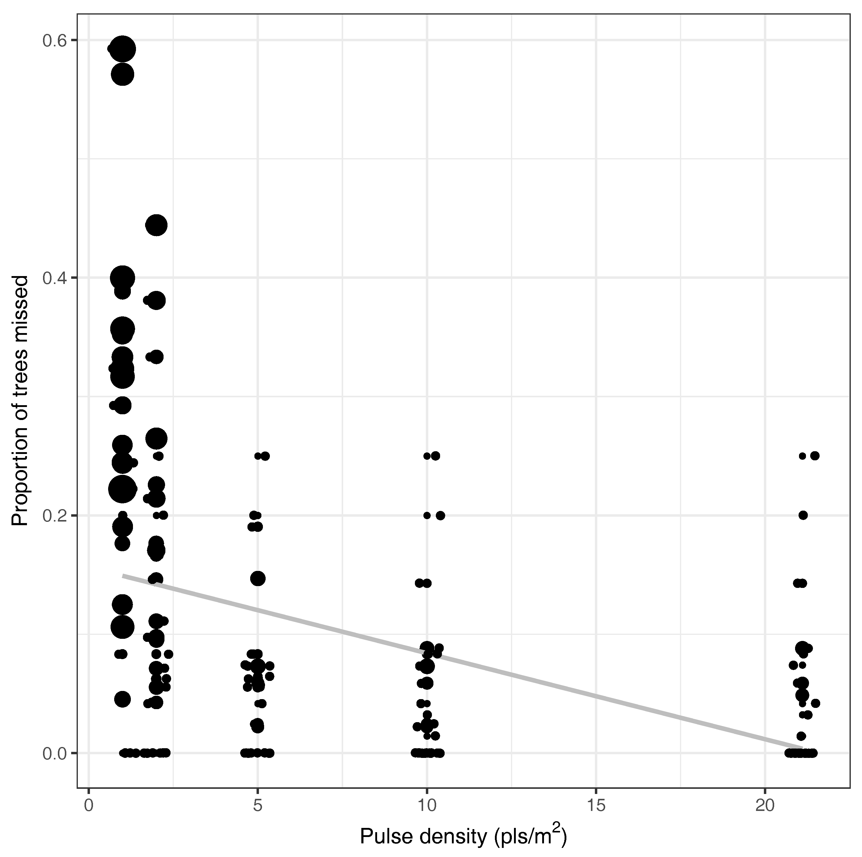
ALS pulse density was investigated in this research and, as expected, was found to have very little impact on classification accuracy. However, this result should not be interpreted as an indication that low-density ALS data are equally as useful for invasive conifer detection as high density data. In addition to the echo classification error, a further source of error is the omission of invasive conifers that are not scanned due to the campaign settings or occlusion from surrounding terrain or vegetation. Further research is required to investigate the effect of pulse density on the probability of detection invasive conifers of various size by remotely-sensed datasets of varying resolution.
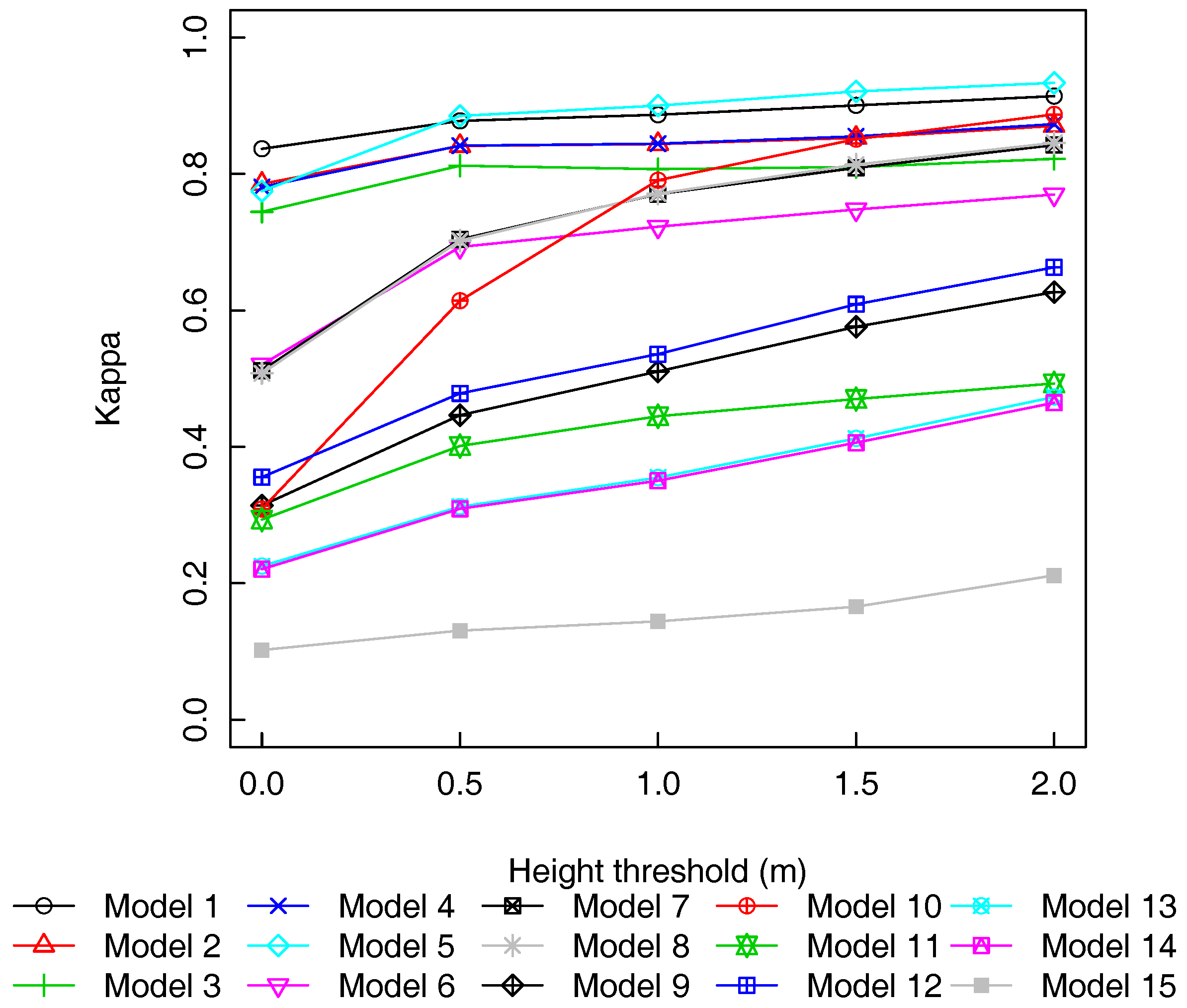
We varied the height threshold used for inclusion in the classification dataset and investigated the effect of height threshold on classification accuracy. This analysis showed that the most accurate models were relatively insensitive to increases in the height threshold. This suggests that these models provide an accurate classification right down to the ground level, and so, the echo classification approach has the potential to correctly identify smaller trees. Interestingly, the model that included all predictors except ALS intensity data (
Table 4, Model 5) was more accurate than Model 1, which included ALS intensity data, at height thresholds exceeding 1 m. This could be because at heights below 1 m, the echo classifier needs to be able to differentiate between invasive conifers and inorganic material (e.g., rocks), and ALS intensity may provide useful information within this height range. However, at higher height thresholds, this is no longer an issue, and so, the ALS intensity data do not contribute to classification accuracy. Model 10 was fitted with spectral data only and was the most sensitive to the height threshold used. When the height threshold was 0 m, the accuracy of the model was only fair, but the accuracy rate increased rapidly with the height threshold, and by 2 m, this was amongst the best performing models. This is most likely caused by the fact that above 2 m, all echoes will be from trees or large shrubby vegetation, and the spectral values have significant power to differentiate between invasive conifers and other vegetation types. This suggests that aerial imagery has utility for detecting larger invasive trees, but if detection prior to maturity is required, then ALS data, in combination with spectral values, have greater capacity for detection.
The characteristics of the ALS survey and the size of the target have a significant effect on the probability of invasive conifers being included in the campaign out-of-sample error. This result has important practical implications for guiding suitable campaign settings for invasive conifer detection. Below 5 pls/m
2, considerably more invasive conifers were missed, and those missed individuals were also considerably larger. Detecting and eradicating invasive conifers before they start to produce cones is vital to controlling conifer spread and minimising their ecological impact. As a result, based on the evidence presented in this paper, it is suggested that a pulse density of 5 pls/m
2 or greater should be used if invasive conifer detection is a major objective of the data acquisition. For large-scale management, it may be infeasible to collect ALS data at this density due to financial or time constraints. In these situations, successive, lower density surveys may offer the possibility to detect missed individuals as height and canopy volume increases while background objects that interfere with detection, such as rocks and mounds, remain static [
19,
20]. The high growth rates of invasive conifers may further assist detection from repeated surveys. Estimates from Ledgard and Paul [
10] suggest that during the earlier stages of invasion, height growth for
Pinus contorta Dougl. ex Loudon (one of the most problematic species) may be as high as 30 cm per annum. This is significantly higher than growth rates in the boreal ecotone, where research has shown that data from multi-temporal ALS campaigns contains valuable data for monitoring changes in the tree-line [
71]. The time required before previously undetected invasive conifers would reach sufficient height and crown diameter to be detected in subsequent lower density surveys may be quite short, and the implementation of this approach may represent an effective and efficient means of monitoring and controlling the spread of invasive conifers over large areas of New Zealand.


