
Inverting Aboveground Biomass–Canopy Texture Relationships in a Landscape of Forest Mosaic in the Western Ghats of India Using Very High Resolution Cartosat Imagery

 , , and
Abstract
:
1. Introduction
2. Materials and Methods
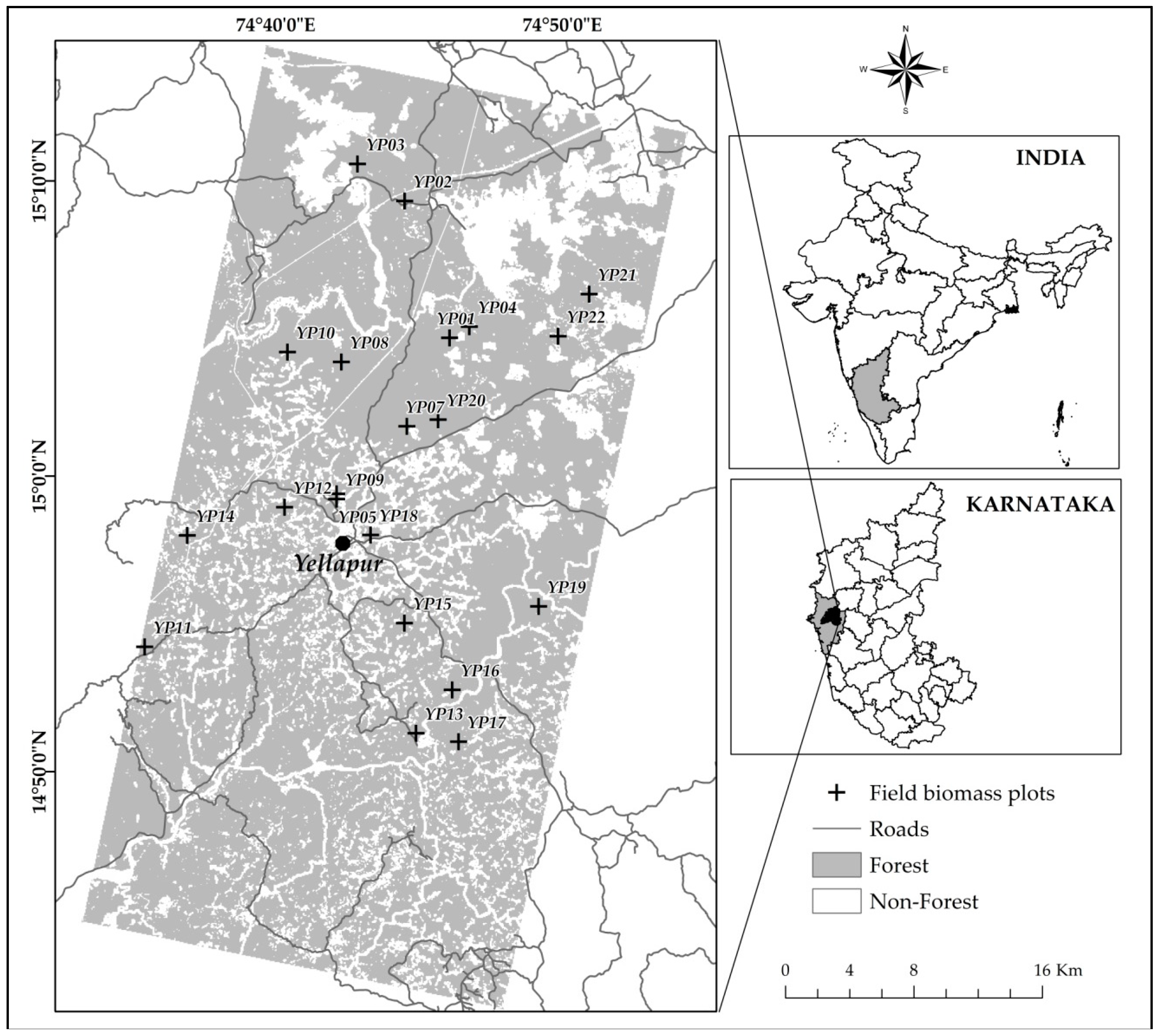
2.1. Study Area
2.2. Datasets
2.3. Field Plot Establishment, Tree Inventory
2.4. Plot-Level Biomass Estimation and Error Propagation
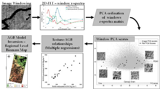
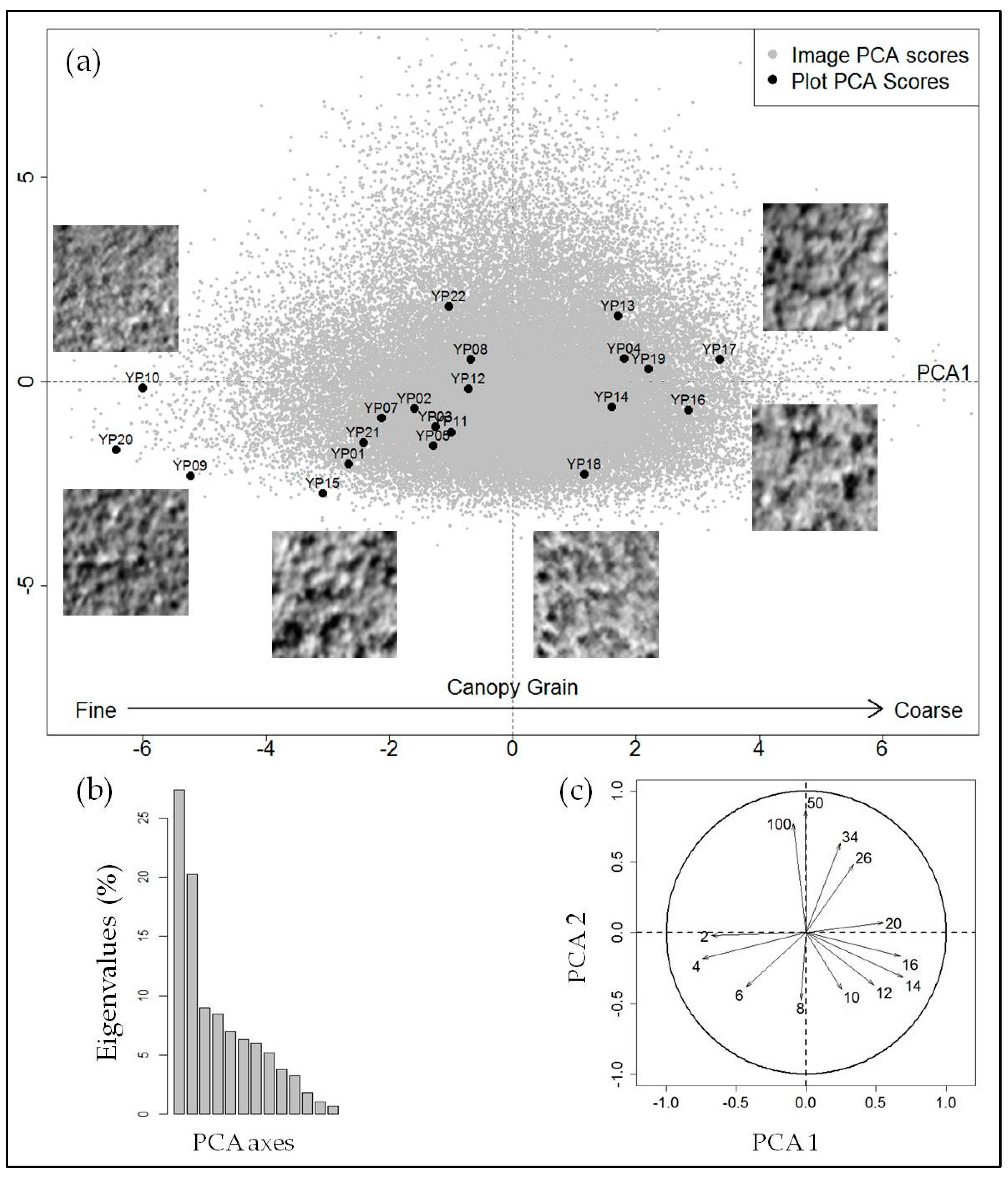
2.5. Fourier Transform Textural Ordination (FOTO)
2.6. Texture–AGB Model Selection, Validtion and Inversion
3. Results
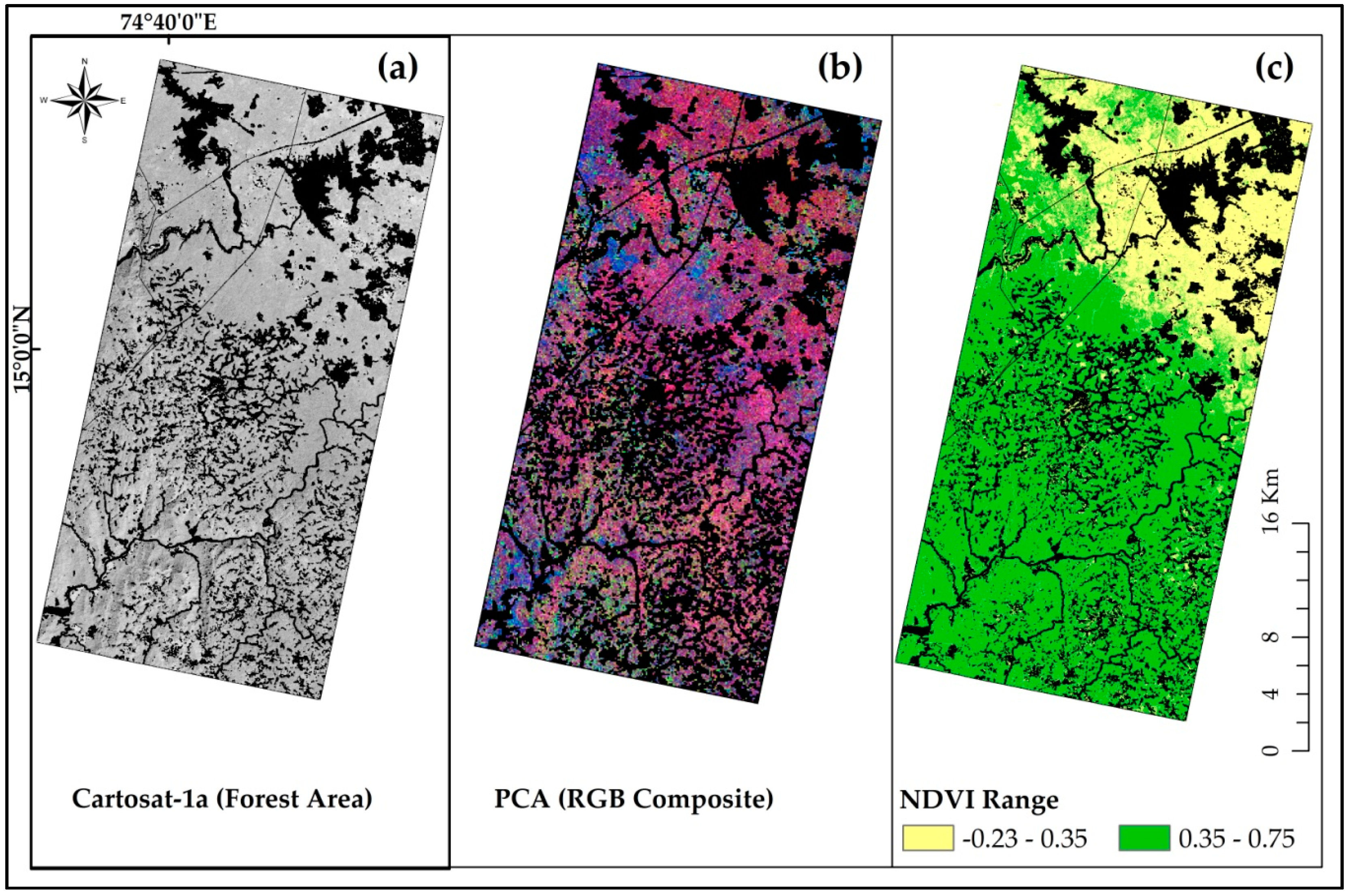
3.1. Landscape Scale Mapping of Forest Canopy Texture
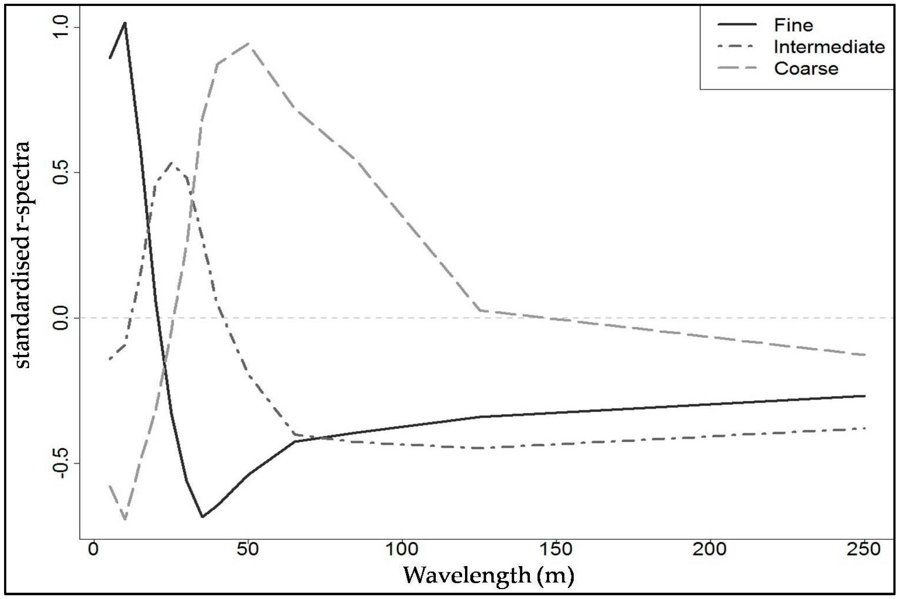
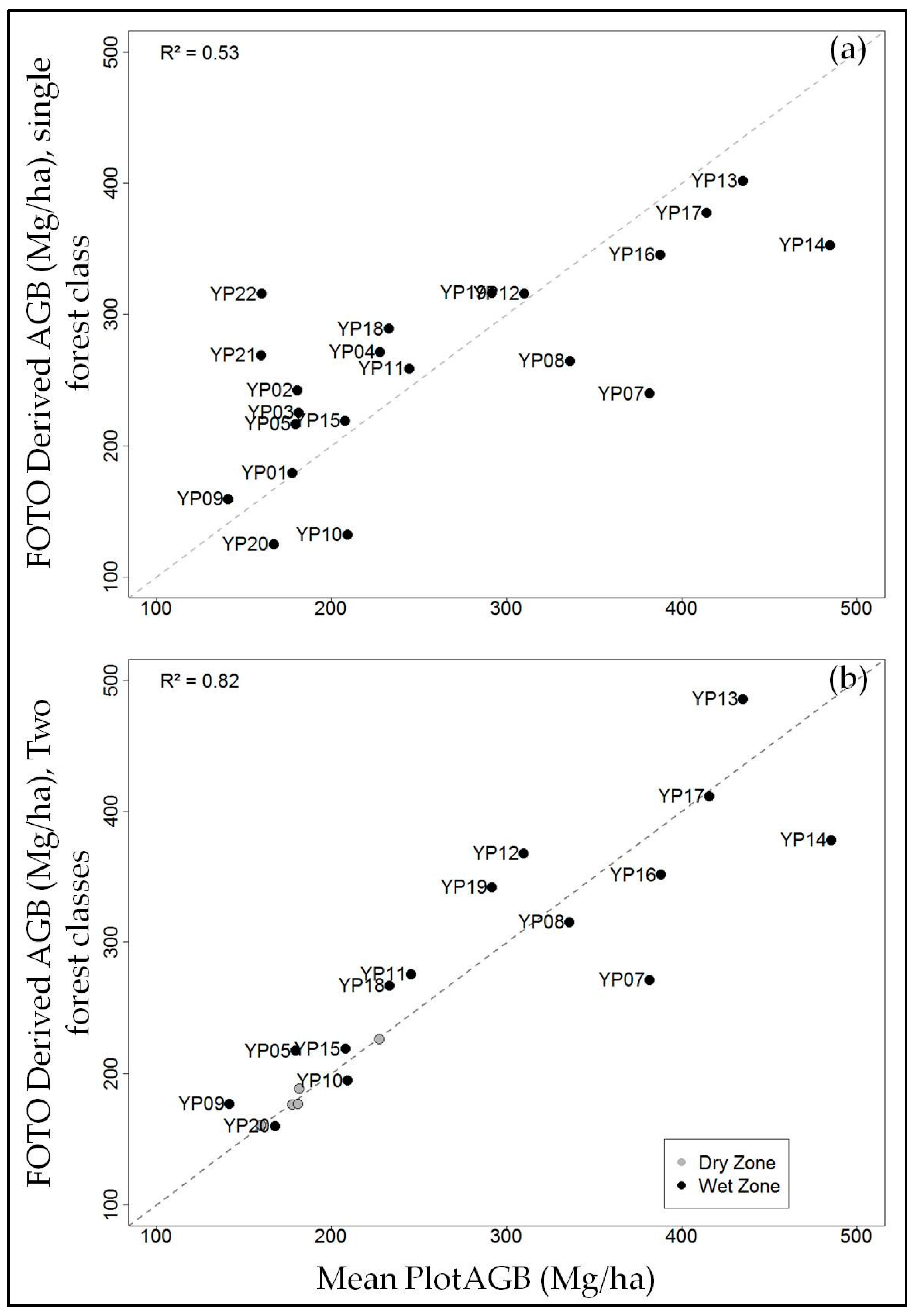
3.2. Canopy Texture–AGB Relationships
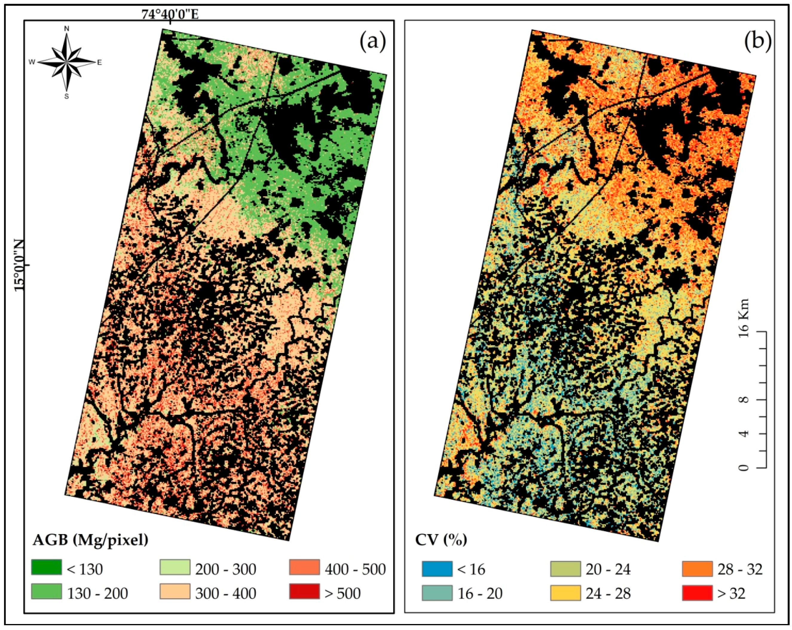
3.3. Mapping Forest Aboveground Biomass
4. Discussion
4.1. Predictive Power of FOTO in Estimating Stand Structure Parameters
4.2. Effect of Different Forest Types Present in the Study Area
4.3. Potential of Cartosat-1a Imagery
5. Conclusions
Acknowledgments
Author Contributions
Conflicts of Interest
References
- Carlowicz, M. Seeing Forests for the Trees and the Carbon: Mapping the World’s Forests in Three Dimensions: Feature Articles. Available online: http://earthobservatory.nasa.gov/Features/ForestCarbon/printall.php (accessed on 17 January 2016).
- Intergovernmental Panel on Climate Change (IPCC). Climate Change 2007: Synthesis Report. Contribution of Working Groups I, II and III to the Fourth Assessment Report of the Intergovernmental Panel on Climate Change; IPCC: Geneva, Switzerland, 2008. [Google Scholar]
- Intergovernmental Panel on Climate Change (IPCC). Climate Change 2014: Synthesis Report; Intergovernmental Panel on Climate Change: Geneva, Switzerland, 2015. [Google Scholar]
- Van der Werf, G.R.; Morton, D.C.; DeFries, R.S.; Olivier, J.G.J.; Kasibhatla, P.S.; Jackson, R.B.; Collatz, G.J.; Randerson, J.T. CO2 emissions from forest loss. Nat. Geosci. 2009, 2, 737–738. [Google Scholar] [CrossRef]
- Harris, N.L.; Brown, S.; Hagen, S.C.; Saatchi, S.S.; Petrova, S.; Salas, W.; Hansen, M.C.; Potapov, P.V.; Lotsch, A. Baseline Map of Carbon Emissions from Deforestation in Tropical Regions. Science 2012, 336, 1573–1576. [Google Scholar] [CrossRef] [PubMed]
- Houghton, R.A. Aboveground Forest Biomass and the Global Carbon Balance. Glob. Chang. Biol. 2005, 11, 945–958. [Google Scholar] [CrossRef]
- Chapin, F.S.; Matson, P.A.; Mooney, H.A. Principles of Terrestrial Ecosystem Ecology; Springer: New York, NY, USA, 2002. [Google Scholar]
- Gibbs, H.K.; Brown, S.; Niles, J.O.; Foley, J.A. Monitoring and estimating tropical forest carbon stocks: Making REDD a reality. Environ. Res. Lett. 2007, 2, 045023. [Google Scholar] [CrossRef]
- Houghton, R.A.; Hall, F.; Goetz, S.J. Importance of biomass in the global carbon cycle. J. Geophys. Res. 2009. [Google Scholar] [CrossRef]
- DeFries, R.; Achard, F.; Brown, S.; Herold, M.; Murdiyarso, D.; Schlamadinger, B.; de Souza, C. Earth observations for estimating greenhouse gas emissions from deforestation in developing countries. Environ. Sci. Policy 2007, 10, 385–394. [Google Scholar] [CrossRef]
- Gibbs, H.K.; Ruesch, A.S.; Achard, F.; Clayton, M.K.; Holmgren, P.; Ramankutty, N.; Foley, J.A. Tropical forests were the primary sources of new agricultural land in the 1980s and 1990s. Proc. Natl. Acad. Sci. USA 2010, 107, 16732–16737. [Google Scholar] [CrossRef] [PubMed]
- Herold, M.; Román-Cuesta, R.; Mollicone, D.; Hirata, Y.; Van Laake, P.; Asner, G.P.; Souza, C.; Skutsch, M.; Avitabile, V.; MacDicken, K. Options for monitoring and estimating historical carbon emissions from forest degradation in the context of REDD+. Carbon Balance Manag. 2011, 6, 13. [Google Scholar] [CrossRef] [PubMed]
- Saatchi, S.S.; Harris, N.L.; Brown, S.; Lefsky, M.; Mitchard, E.T.A.; Salas, W.; Zutta, B.R.; Buermann, W.; Lewis, S.L.; Hagen, S.; et al. Benchmark map of forest carbon stocks in tropical regions across three continents. Proc. Natl. Acad. Sci. USA 2011, 108, 9899–9904. [Google Scholar] [CrossRef] [PubMed]
- Reddy, C.S.; Rakesh, F.; Jha, C.S.; Athira, K.; Singh, S.; Alekhya, V.V.L.P.; Rajashekar, G.; Diwakar, P.G.; Dadhwal, V.K. Geospatial assessment of long-term changes in carbon stocks and fluxes in forests of India (1930–2013). Glob. Planet. Chang. 2016, 143, 50–65. [Google Scholar] [CrossRef]
- Réjou-Méchain, M.; Muller-Landau, H.C.; Detto, M.; Thomas, S.C.; Le Toan, T.; Saatchi, S.S.; Barreto-Silva, J.S.; Bourg, N.A.; Bunyavejchewin, S.; Butt, N.; et al. Local spatial structure of forest biomass and its consequences for remote sensing of carbon stocks. Biogeosciences 2014, 11, 6827–6840. [Google Scholar] [CrossRef] [Green Version]
- Barbier, N.; Proisy, C.; Véga, C.; Sabatier, D.; Couteron, P. Bidirectional texture function of high resolution optical images of tropical forest: An approach using LiDAR hillshade simulations. Remote Sens. Environ. 2011, 115, 167–179. [Google Scholar] [CrossRef]
- Mermoz, S.; Rejou-Mechain, M.; Villard, L.; Le Toan, T.; Rossi, V.; Gourlet-Fleury, S. Biomass of dense forests related to L-band SAR backscatter? In Proceedings of the 2014 IEEE International Geoscience and Remote Sensing Symposium (IGARSS), Quebec City, QC, Canada, 13–18 July 2014.
- Asner, G.P.; Powell, G.V.N.; Mascaro, J.; Knapp, D.E.; Clark, J.K.; Jacobson, J.; Kennedy-Bowdoin, T.; Balaji, A.; Paez-Acosta, G.; Victoria, E.; Secada, L.; et al. High-resolution forest carbon stocks and emissions in the Amazon. Proc. Natl. Acad. Sci. USA 2010, 107, 16738–16742. [Google Scholar] [CrossRef] [PubMed]
- Réjou-Méchain, M.; Tymen, B.; Blanc, L.; Fauset, S.; Feldpausch, T.R.; Monteagudo, A.; Phillips, O.L.; Richard, H.; Chave, J. Using repeated small-footprint LiDAR acquisitions to infer spatial and temporal variations of a high-biomass Neotropical forest. Remote Sens. Environ. 2015, 169, 93–101. [Google Scholar] [CrossRef] [Green Version]
- Baccini, A.; Asner, G.P. Improving pantropical forest carbon maps with airborne LiDAR sampling. Carbon Manag. 2013, 4, 591–600. [Google Scholar] [CrossRef]
- Hill, T.C.; Williams, M.; Bloom, A.A.; Mitchard, E.T.A.; Ryan, C.M. Are Inventory Based and Remotely Sensed Above-Ground Biomass Estimates Consistent? PLoS ONE 2013, 8, e74170. [Google Scholar]
- Mitchard, E.T.A.; Feldpausch, T.R.; Brienen, R.J.W.; Lopez-Gonzalez, G.; Monteagudo, A.; Baker, T.R.; Lewis, S.L.; Lloyd, J.; Quesada, C.A.; Gloor, M.; et al. Markedly divergent estimates of Amazon forest carbon density from ground plots and satellites. Glob. Ecol. Biogeogr. 2014, 23, 935–946. [Google Scholar] [CrossRef] [PubMed] [Green Version]
- Frazer, G.W.; Wulder, M.A.; Niemann, K.O. Simulation and quantification of the fine-scale spatial pattern and heterogeneity of forest canopy structure: A lacunarity-based method designed for analysis of continuous canopy heights. For. Ecol. Manag. 2005, 214, 65–90. [Google Scholar] [CrossRef]
- Couteron, P. Quantifying change in patterned semi-arid vegetation by Fourier analysis of digitized aerial photographs. Int. J. Remote Sens. 2002, 23, 3407–3425. [Google Scholar] [CrossRef]
- Proisy, C.; Couteron, P.; Fromard, F. Predicting and mapping mangrove biomass from canopy grain analysis using Fourier-based textural ordination of IKONOS images. Remote Sens. Environ. 2007, 109, 379–392. [Google Scholar] [CrossRef]
- Ploton, P. Analyzing Canopy Heterogeneity of the Tropical Forests by Texture Analysis of Very-High Resolution Images—A Case Study in the Western Ghats of India; Institut Français de Pondichéry: Puducherry, India, 2010. [Google Scholar]
- Bastin, J.-F.; Barbier, N.; Couteron, P.; Adams, B.; Shapiro, A.; Bogaert, J.; De Cannière, C. Aboveground biomass mapping of African forest mosaics using canopy texture analysis: toward a regional approach. Ecol. Appl. 2014, 24, 1984–2001. [Google Scholar] [CrossRef]
- Singh, M.; Malhi, Y.; Bhagwat, S. Biomass estimation of mixed forest landscape using a Fourier transform texture-based approach on very-high-resolution optical satellite imagery. Int. J. Remote Sens. 2014, 35, 3331–3349. [Google Scholar] [CrossRef]
- Enquist, B.J.; West, G.B.; Brown, J.H. Extensions and evaluations of a general quantitative theory of forest structure and dynamics. Proc. Natl. Acad. Sci. USA 2009, 106, 7046–7051. [Google Scholar] [CrossRef] [PubMed]
- Couteron, P.; Pelissier, R.; Nicolini, E.A.; Paget, D. Predicting tropical forest stand structure parameters from Fourier transform of very high-resolution remotely sensed canopy images: Predicting tropical forest stand structure. J. Appl. Ecol. 2005, 42, 1121–1128. [Google Scholar] [CrossRef] [Green Version]
- Barbier, N.; Couteron, P.; Proisy, C.; Malhi, Y.; Gastellu-Etchegorry, J.-P. The variation of apparent crown size and canopy heterogeneity across lowland Amazonian forests: Amazon forest canopy properties. Glob. Ecol. Biogeogr. 2010, 19, 72–84. [Google Scholar] [CrossRef]
- Couteron, P.; Barbier, N.; Gautier, D. Textural Ordination Based on Fourier Spectral Decomposition: A Method to Analyze and Compare Landscape Patterns. Landsc. Ecol. 2006, 21, 555–567. [Google Scholar] [CrossRef] [Green Version]
- Ploton, P.; Pélissier, R.; Proisy, C.; Flavenot, T.; Barbier, N.; Rai, S.N.; Couteron, P. Assessing aboveground tropical forest biomass using Google Earth canopy images. Ecol. Appl. 2012, 22, 993–1003. [Google Scholar] [CrossRef] [PubMed]
- Clark, D.B.; Kellner, J.R. Tropical forest biomass estimation and the fallacy of misplaced concreteness. J. Veg. Sci. 2012, 23, 1191–1196. [Google Scholar] [CrossRef]
- Chave, J.; Réjou-Méchain, M.; Búrquez, A.; Chidumayo, E.; Colgan, M.S.; Delitti, W.B.C.; Duque, A.; Eid, T.; Fearnside, P.M.; Goodman, R.C.; et al. Improved allometric models to estimate the aboveground biomass of tropical trees. Glob. Chang. Biol. 2014, 20, 3177–3190. [Google Scholar] [CrossRef] [PubMed]
- Molto, Q.; Rossi, V.; Blanc, L. Error propagation in biomass estimation in tropical forests. Methods Ecol. Evol. 2013, 4, 175–183. [Google Scholar] [CrossRef]
- Chave, J.; Condit, R.; Aguilar, S.; Hernandez, A.; Lao, S.; Perez, R. Error propagation and scaling for tropical forest biomass estimates. Philos. Trans. R. Soc. B Biol. Sci. 2004, 359, 409–420. [Google Scholar] [CrossRef] [PubMed]
- Chen, Q.; Vaglio Laurin, G.; Valentini, R. Uncertainty of remotely sensed aboveground biomass over an African tropical forest: Propagating errors from trees to plots to pixels. Remote Sens. Environ. 2015, 160, 134–143. [Google Scholar] [CrossRef]
- Gonzalez, P.; Asner, G.P.; Battles, J.J.; Lefsky, M.A.; Waring, K.M.; Palace, M. Forest carbon densities and uncertainties from Lidar, QuickBird, and field measurements in California. Remote Sens. Environ. 2010, 114, 1561–1575. [Google Scholar] [CrossRef]
- Gunnell, Y.; Bourgeon, G. Soils and climatic geomorphology on the Karnataka plateau, peninsular India. Catena 1997, 29, 239–262. [Google Scholar] [CrossRef]
- Pascal, J.-P. Wet Evergreen Forests of the Western Ghats of India. Ecology, Structure, Floristic Composition and Successio; Institut Français de Pondichéry: Puducherry, India, 1988. [Google Scholar]
- Pascal, J.-P. Explanatory Booklet on the Forest Map of South India. Sheets: Belgaum-Dharwar-Panaji, Shimoga, Mercara-Mysore; Travaux de la Section Scientifique et Technique. Hors Série N° 18; Institut Français de Pondichéry: Puducherry, India, 1986. [Google Scholar]
- Champion, H.G.; Seth, S.K. A Revised Survey of the Forest Types of India; Natraj Publishers: Dehra Dun, India, 2005. [Google Scholar]
- Ramesh, B.R.; Venugopal, P.D.; Pélissier, R.; Patil, S.V.; Swaminath, M.H.; Couteron, P. Mesoscale Patterns in the Floristic Composition of Forests in the Central Western Ghats of Karnataka, India: Floristic Composition of Forests. Biotropica 2010, 42, 435–443. [Google Scholar] [CrossRef]
- CARTOSAT-1-ISRO. Available online: http://www.isro.gov.in/Spacecraft/cartosat-%E2%80%93-1 (accessed on 7 September 2016).
- Ramesh, B.R.; Seetharam, M.; Guero, M.C.; Michon, R. Assessment and Conservation of Forest Biodiversity in the Western Ghats of Karnataka, India. 1. General Introduction and Forest Land Cover and Land Use Changes (1977–1997); Pondy Papers in Ecology No. 6; Institut Français de Pondichéry: Puducherry, India, 2009. [Google Scholar]
- Map|India Biodiversity. Available online: http://indiabiodiversity.org/map# (accessed on 8 September 2016).
- OpenStreetMap. Available online: http://www.openstreetmap.org/ (accessed on 5 September 2016).
- Ploton, P.; Pélissier, R.; Barbier, N.; Proisy, C.; Ramesh, B.R.; Couteron, P. Canopy texture analysis for large-scale assessments of tropical forest stand structure and biomass. In Treetops at Risk; Lowman, M., Devy, S., Ganesh, T., Eds.; Springer: New York, NY, USA, 2013; pp. 237–245. [Google Scholar]
- Kane, V. R.; Gillespie, A. R.; McGaughey, R.; Lutz, J. A.; Ceder, K.; Franklin, J. F. Interpretation and topographic compensation of conifer canopy self-shadowing. Remote Sens. Environ. 2008, 112, 3820–3832. [Google Scholar] [CrossRef]
- Phillips, O.; Baker, T.; Feldpausch, T.R.; Brienen, R. RAINFOR Field Manual for Plot Establishment and Remeasurement; Moore Found: Leeds, UK, 2009. [Google Scholar]
- Condit, R. Methods for Estimating Aboveground Biomass of Forest and Replacement Vegetation in the Tropics; Center for Tropical Forest Science Research: Ancon, Panama, 2008. [Google Scholar]
- Zanne, A.E.; Lopez-Gonzalez, G.; Coomes, D.A.; Ilic, J.; Jansen, S.; Lewis, S.L.; Miller, R.B.; Swenson, N.G.; Wiemann, M.C.; Chave, J. Data from: Towards a worldwide wood economics spectrum. Dryad 2009. [Google Scholar] [CrossRef]
- Réjou-Méchain, M.; Tanguy, A.; Piponiot, C.; Chave, J.; Hérault, B. BIOMASS: An R Package for estimating above-ground biomass and its uncertainty in tropical forests. Methods Ecol. Evol. 2017. [Google Scholar] [CrossRef]
- Molto, Q.; Hérault, B.; Boreux, J.-J.; Daullet, M.; Rousteau, A.; Rossi, V. Predicting tree heights for biomass estimates in tropical forests—A test from French Guiana. Biogeosciences 2014, 11, 3121–3130. [Google Scholar] [CrossRef]
- Renshaw, E.; Ford, E.D. The Description of Spatial Pattern Using Two-Dimensional Spectral Analysis. Vegetatio 1984, 56, 75–85. [Google Scholar]
- Mugglestone, M.A.; Renshaw, E. Detection of geological lineations on aerial photographs using two-dimensional spectral analysis. Comput. Geosci. 1998, 24, 771–784. [Google Scholar] [CrossRef]
- Sommerfeld, R.; Lundquist, J.; Smith, J. Characterizing the canopy gap structure of a disturbed forest using the Fourier transform. For. Ecol. Manag. 2000, 128, 101–108. [Google Scholar] [CrossRef]
- Barbier, N.; Couteron, P. Attenuating the bidirectional texture variation of satellite images of tropical forest canopies. Remote Sens. Environ. 2015, 171, 245–260. [Google Scholar] [CrossRef]
- Percival, D.B.; Walden, A.T. Spectral Analysis for Physical Applications: Multitaper and Conventional Univariate Techniques; Cambridge University Press: Cambridge, UK, 1993. [Google Scholar]
- Picard, R.R.; Cook, R.D. Cross-Validation of Regression Models. J. Am. Stat. Assoc. 1984, 79, 575–583. [Google Scholar] [CrossRef]
- Madugundu, R.; Nizalapur, V.; Jha, C.S. Estimation of LAI and above-ground biomass in deciduous forests: Western Ghats of Karnataka, India. Int. J. Appl. Earth Obs. Geoinf. 2008, 10, 211–219. [Google Scholar] [CrossRef]
- Barbier, N.; Couteron, P.; Gastelly-Etchegorry, J.-P.; Proisy, C. Linking canopy images to forest structural parameters: Potential of a modeling framework. Ann. For. Sci. 2012, 69, 305–311. [Google Scholar] [CrossRef] [Green Version]
- Bastin, J.-F.; Barbier, N.; Réjou-Méchain, M.; Fayolle, A.; Gourlet-Fleury, S.; Maniatis, D.; de Haulleville, T.; Baya, F.; Beeckman, H.; Beina, D.; et al. Seeing Central African forests through their largest trees. Sci. Rep. 2015, 5, 13156. [Google Scholar] [CrossRef] [PubMed]
- Ploton, P.; Barbier, N.; Takoudjou Momo, S.; Réjou-Méchain, M.; Boyemba Bosela, F.; Chuyong, G.; Dauby, G.; Droissart, V.; Fayolle, A.; Goodman, R.C.; et al. Closing a gap in tropical forest biomass estimation: Taking crown mass variation into account in pantropical allometries. Biogeosciences 2016, 13, 1571–1585. [Google Scholar] [CrossRef] [Green Version]
- Zolkos, S.G.; Goetz, S.J.; Dubayah, R. A meta-analysis of terrestrial aboveground biomass estimation using lidar remote sensing. Remote Sens. Environ. 2013, 128, 289–298. [Google Scholar] [CrossRef]
- SPOT-6 and 7-eoPortal Directory—Satellite Missions. Available online: https://directory.eoportal.org/web/eoportal/satellite-missions/s/spot-6-7 (accessed on 7 September 2016).


| Satellite | Cartosat-1 (IRS-P5) | Resourcesat-2 |
|---|---|---|
| Sensor | PAN_AFT | LISS4 |
| Agency | NRSC, India | NRSC, India |
| Date of Pass | 13/02/2015 | 23/01/2013 |
| Resolution (m) | 2.5 | 5.8 |
| No of Scenes | 2 | 2 |
| No of Bands | 1 (PAN) | 1 (mono), 3 (Multispectral) |
| Spectral Bands | 0.5 µm–0.85 µm | B2: 0.52–0.59 µm; B3: 0.62–0.68 µm; B4: 0.77–0.86 µm; B3-default band for mono |
| Swath (km) | 26.24 | 70 |
| Altitude (km) | 620 | 823 |
| Revisit Days | 5 | 5 |
| Image Format | GeoTIFF | GeoTIFF |
| Source | www.nrsc.gov.in/cartosat-1 | www.isro.gov.in/Spacecraft/resourcesat-2 |
| Plot ID | X Coordinate (E) | Y Coordinate (N) | Forest Class | Texture Class | Stem Count | Species/Plot | Basal Area (m2) | QMD (cm) | Mean WD (g/cm3) | Dmax (cm) | Hmax (m) | AGB (Mg·ha−1) | 95% CI (Mg·ha−1) | |
|---|---|---|---|---|---|---|---|---|---|---|---|---|---|---|
| YP01 | 74°46′4.9′′ | 15°4′42.1′′ | Dry Deciduous | Fine | 253 | 26 | 20.84 | 32.40 | 0.737 | 67.5 | 26 | 177.64 | 164.89 | 192.52 |
| YP02 | 74°44′31.6′′ | 15°9′19.9′′ | Dry Deciduous | Intermediate | 378 | 14 | 22.63 | 27.61 | 0.638 | 83.2 | 29 | 181.11 | 166.30 | 197.00 |
| YP03 | 74°42′51.7′′ | 15°10′3′′ | Dry Deciduous | Intermediate | 219 | 18 | 20.45 | 34.49 | 0.739 | 87.8 | 28.5 | 181.69 | 165.90 | 197.68 |
| YP04 | 74°46′46.0′′ | 15°5′4.9′′ | Dry Deciduous | Coarse | 149 | 16 | 22.90 | 44.25 | 0.709 | 118.7 | 30 | 227.57 | 205.51 | 250.46 |
| YP05 | 74°42′8.8′′ | 14°59′24.7′′ | Moist Deciduous | Intermediate | 415 | 41 | 21.43 | 25.65 | 0.736 | 80 | 28.5 | 179.61 | 163.82 | 197.28 |
| YP07 | 74°44′35.7′′ | 15°1′42′′ | Moist Deciduous | Intermediate | 299 | 26 | 35.44 | 38.86 | 0.674 | 110.6 | NA | 381.74 | 353.93 | 414.21 |
| YP08 | 74°42′18.4′′ | 15°3′52.6′′ | Moist Deciduous | Intermediate | 245 | 15 | 33.38 | 41.66 | 0.690 | 146.2 | 36 | 336.13 | 303.22 | 367.22 |
| YP09 | 74°42’′8.8′′ | 14°59′13.9′′ | Moist Deciduous | Fine | 627 | 49 | 23.08 | 21.66 | 0.623 | 77 | 33 | 141.82 | 128.59 | 153.33 |
| YP10 | 74°40′25.6′′ | 15°4′12,7′′ | Moist Deciduous | Fine | 631 | 21 | 26.37 | 23.07 | 0.713 | 60.5 | 25 | 209.26 | 200.04 | 218.49 |
| YP11 | 74°35′28.2′′ | 14°54′13.5′′ | Evergreen | Intermediate | 838 | 39 | 32.50 | 22.23 | 0.710 | 89.2 | 30.5 | 245.57 | 230.12 | 261.49 |
| YP12 | 74°40′20.1′′ | 14°58′57.3′′ | Evergreen | Intermediate | 454 | 42 | 33.57 | 30.69 | 0.539 | 100.8 | 36.5 | 309.74 | 285.23 | 337.33 |
| YP13 | 74°44′55.6′′ | 14°51′18.8′′ | Evergreen | Coarse | 527 | 27 | 36.44 | 29.68 | 0.695 | 103.4 | 36.5 | 435.06 | 402.94 | 470.20 |
| YP14 | 74°36′56.8 | 14°57'59.9′′ | Evergreen | Coarse | 469 | 44 | 43.68 | 34.44 | 0.558 | 156 | 39 | 485.56 | 437.77 | 534.81 |
| YP15 | 74°44′31.1′′ | 14°55′2.4′′ | Evergreen | Fine | 687 | 42 | 29.08 | 23.22 | 0.691 | 92 | 27 | 208.09 | 189.53 | 225.86 |
| YP16 | 74°46′11.1′′ | 14°52′48′′ | Evergreen | Coarse | 697 | 39 | 38.88 | 26.66 | 0.555 | 105 | 43.5 | 388.24 | 356.99 | 422.50 |
| YP17 | 74°46′24/4′′ | 14°51′1.7′′ | Evergreen | Coarse | 394 | 41 | 32.39 | 32.36 | 0.611 | 126.4 | 45 | 415.85 | 372.24 | 459.74 |
| YP18 | 74°43′20.1′′ | 14°58′1.2′′ | Moist Deciduous | Intermediate | 172 | 30 | 24.93 | 42.97 | 0.557 | 105.2 | 34 | 233.21 | 207.61 | 257.01 |
| YP19 | 74°49′11.4′′ | 14°55′36.5′′ | Moist Deciduous | Coarse | 365 | 20 | 31.40 | 33.10 | 0.637 | 105 | 36.5 | 291.80 | 267.20 | 320.40 |
| YP20 | 74°45′41′′ | 15°1′55.7′′ | Moist Deciduous | Fine | 665 | 28 | 23.98 | 21.43 | 0.710 | 48.1 | 31 | 167.83 | 160.00 | 174.76 |
| YP21 | 74°50′56.8′′ | 15°6′11′′ | Dry Deciduous | Fine | 171 | 8 | 18.86 | 37.49 | 0.728 | 71.6 | 32.5 | 160.03 | 147.22 | 173.73 |
| YP22 | 74°49′51.7′′ | 15°4′45,5′′ | Dry Deciduous | Intermediate | 258 | 18 | 18.91 | 30.56 | 0.739 | 58.7 | 24 | 159.82 | 148.87 | 170.73 |
| Parameters | Estimate | SE | t | P | R2 | RMSE | rRMSE (%) | RSE | rRSE (%) |
|---|---|---|---|---|---|---|---|---|---|
| All Plots (n = 21) | |||||||||
| Intercept | 327.28 | 27.72 | 11.807 | 0.000 | |||||
| a | 17.62 | 7.62 | 2.311 | 0.034 | |||||
| b | 11.03 | 15.90 | 0.694 | 0.497 | |||||
| c | −30.26 | 17.53 | −1.726 | 0.103 | |||||
| Model | 0.004 | 0.53 | 70.18 | 26.71 | 78.46 | 29.86 | |||
| Dry Zone Plots (n = 6) | |||||||||
| Intercept | 166.26 | 4.20 | 39.61 | 0.001 | |||||
| a | 5.66 | 1.68 | 3.37 | 0.078 | |||||
| b | −1.89 | 1.67 | −1.13 | 0.375 | |||||
| c | 8.67 | 1.73 | 5.02 | 0.037 | |||||
| Model | 0.021 | 0.98 | 1.52 | 0.87 | 3.39 | 1.94 | |||
| Wet Zone Plots (n = 15) | |||||||||
| Intercept | 376.16 | 25.87 | 14.54 | 0.000 | |||||
| a | 10.48 | 6.88 | 1.52 | 0.156 | |||||
| b | 34.60 | 14.85 | 2.33 | 0.040 | |||||
| c | −39.06 | 19.44 | −2.01 | 0.070 | |||||
| Model | 0.001 | 0.76 | 50.45 | 17.08 | 59.69 | 20.21 | |||
| Measured vs. Predicted AGB (n = 21) | 0.82 | 43.52 | 16.68 | 41.54 | 15.93 | ||||
© 2017 by the authors. Licensee MDPI, Basel, Switzerland. This article is an open access article distributed under the terms and conditions of the Creative Commons Attribution (CC BY) license ( http://creativecommons.org/licenses/by/4.0/).
Share and Cite
Pargal, S.; Fararoda, R.; Rajashekar, G.; Balachandran, N.; Réjou-Méchain, M.; Barbier, N.; Jha, C.S.; Pélissier, R.; Dadhwal, V.K.; Couteron, P. Inverting Aboveground Biomass–Canopy Texture Relationships in a Landscape of Forest Mosaic in the Western Ghats of India Using Very High Resolution Cartosat Imagery. Remote Sens. 2017, 9, 228. https://doi.org/10.3390/rs9030228
Pargal S, Fararoda R, Rajashekar G, Balachandran N, Réjou-Méchain M, Barbier N, Jha CS, Pélissier R, Dadhwal VK, Couteron P. Inverting Aboveground Biomass–Canopy Texture Relationships in a Landscape of Forest Mosaic in the Western Ghats of India Using Very High Resolution Cartosat Imagery. Remote Sensing. 2017; 9(3):228. https://doi.org/10.3390/rs9030228
Chicago/Turabian StylePargal, Sourabh, Rakesh Fararoda, Gopalakrishnan Rajashekar, Natesan Balachandran, Maxime Réjou-Méchain, Nicolas Barbier, Chandra Shekhar Jha, Raphaël Pélissier, Vinay Kumar Dadhwal, and Pierre Couteron. 2017. "Inverting Aboveground Biomass–Canopy Texture Relationships in a Landscape of Forest Mosaic in the Western Ghats of India Using Very High Resolution Cartosat Imagery" Remote Sensing 9, no. 3: 228. https://doi.org/10.3390/rs9030228
APA StylePargal, S., Fararoda, R., Rajashekar, G., Balachandran, N., Réjou-Méchain, M., Barbier, N., Jha, C. S., Pélissier, R., Dadhwal, V. K., & Couteron, P. (2017). Inverting Aboveground Biomass–Canopy Texture Relationships in a Landscape of Forest Mosaic in the Western Ghats of India Using Very High Resolution Cartosat Imagery. Remote Sensing, 9(3), 228. https://doi.org/10.3390/rs9030228