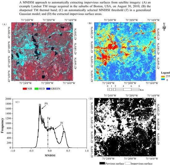
A Modified Normalized Difference Impervious Surface Index (MNDISI) for Automatic Urban Mapping from Landsat Imagery
Abstract
:1. Introduction
2. Study Area and Datasets
2.1. Study Area
2.2. Datasets
3. Methodology
3.1. The Modified Normalized Difference Impervious Surface Index (MNDISI)
3.2. Automatic Threshold Selection of the MNDISI
3.3. Performance Evaluation
4. Results and Analyses
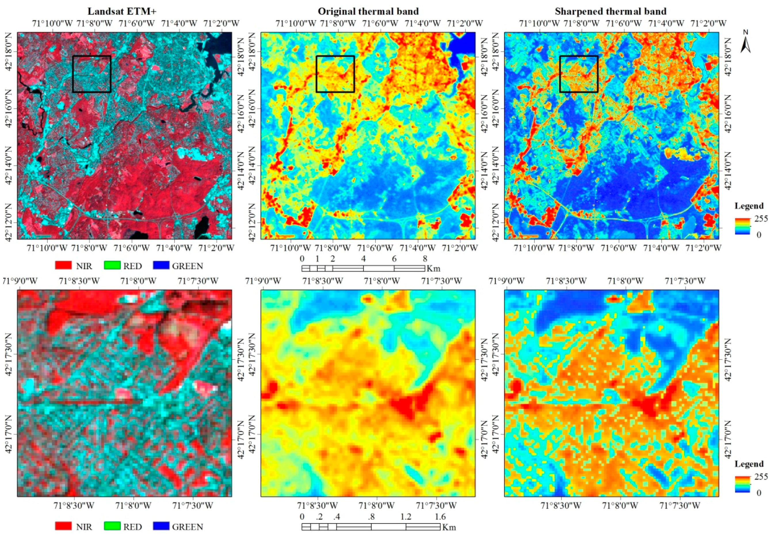
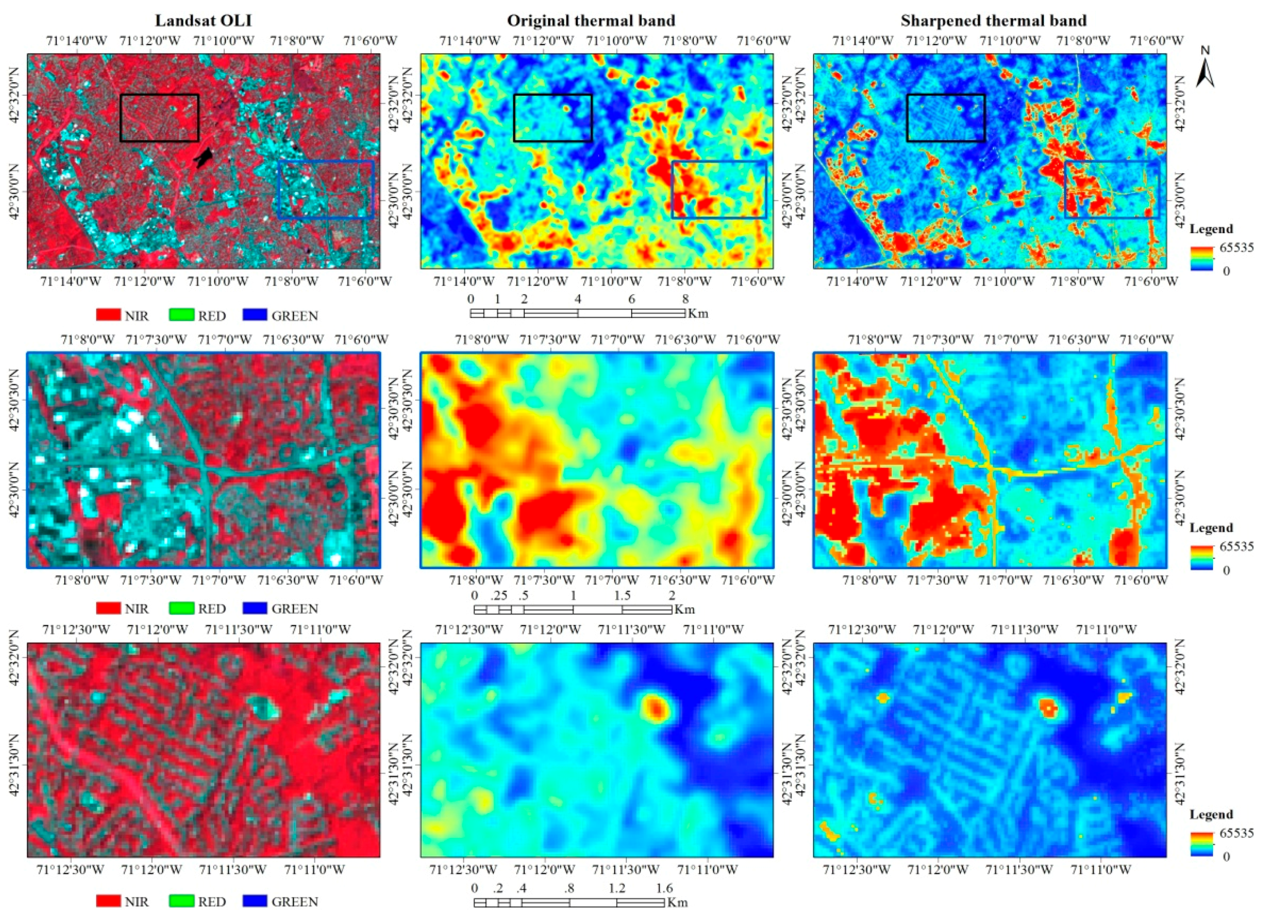
4.1. The Sharpened TIR Imagery
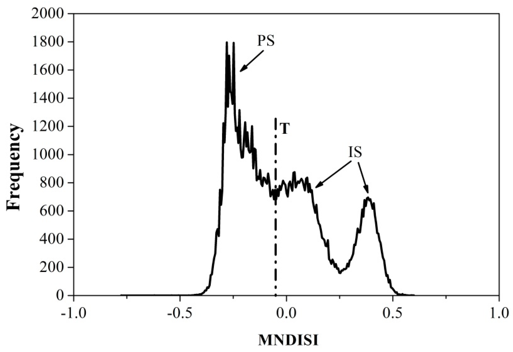
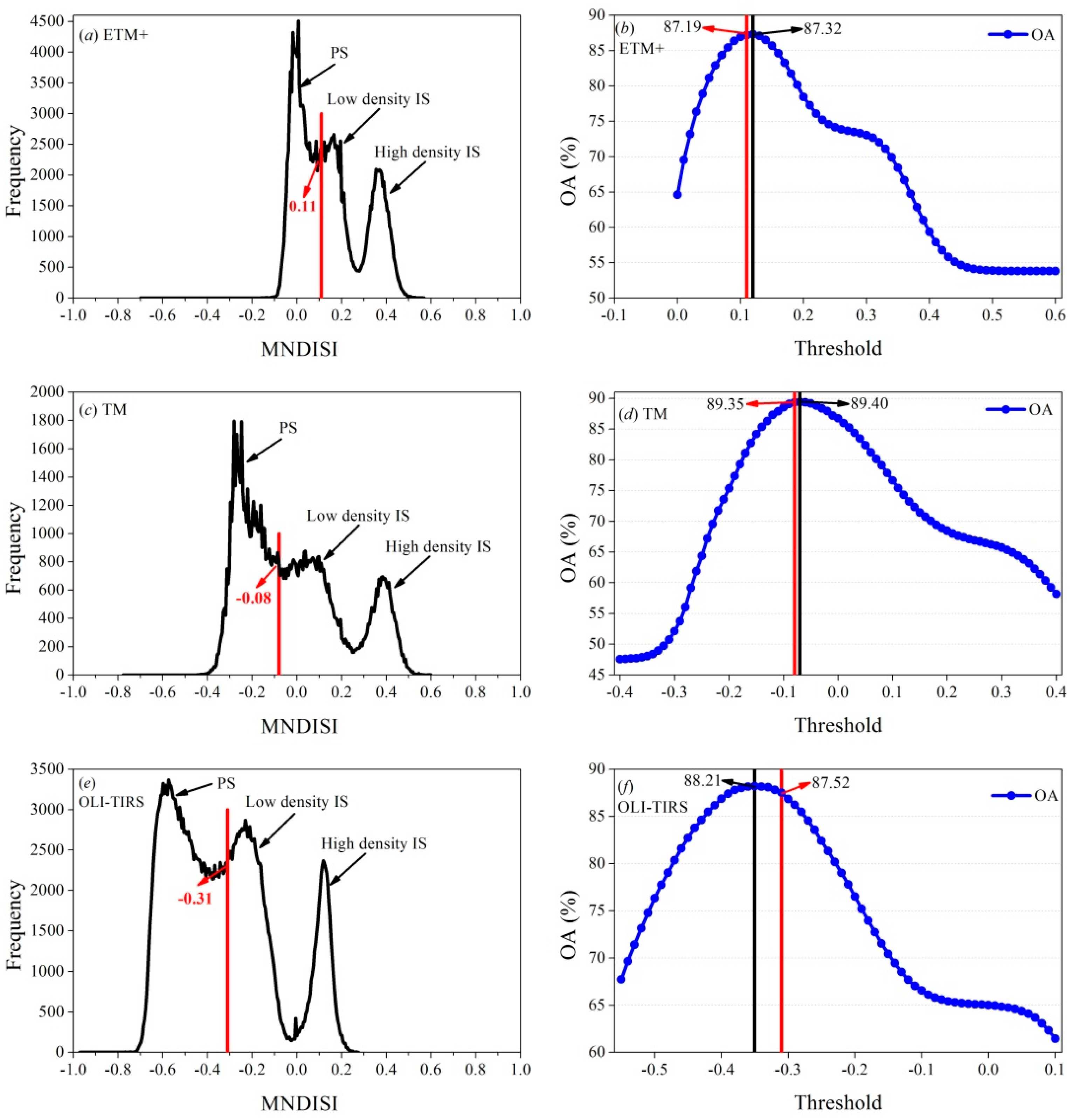
4.2. Automatic Threshold Selection for ISA Mapping
4.3. Performance Evaluation
4.3.1. Seasonality Analysis for ISA Mapping
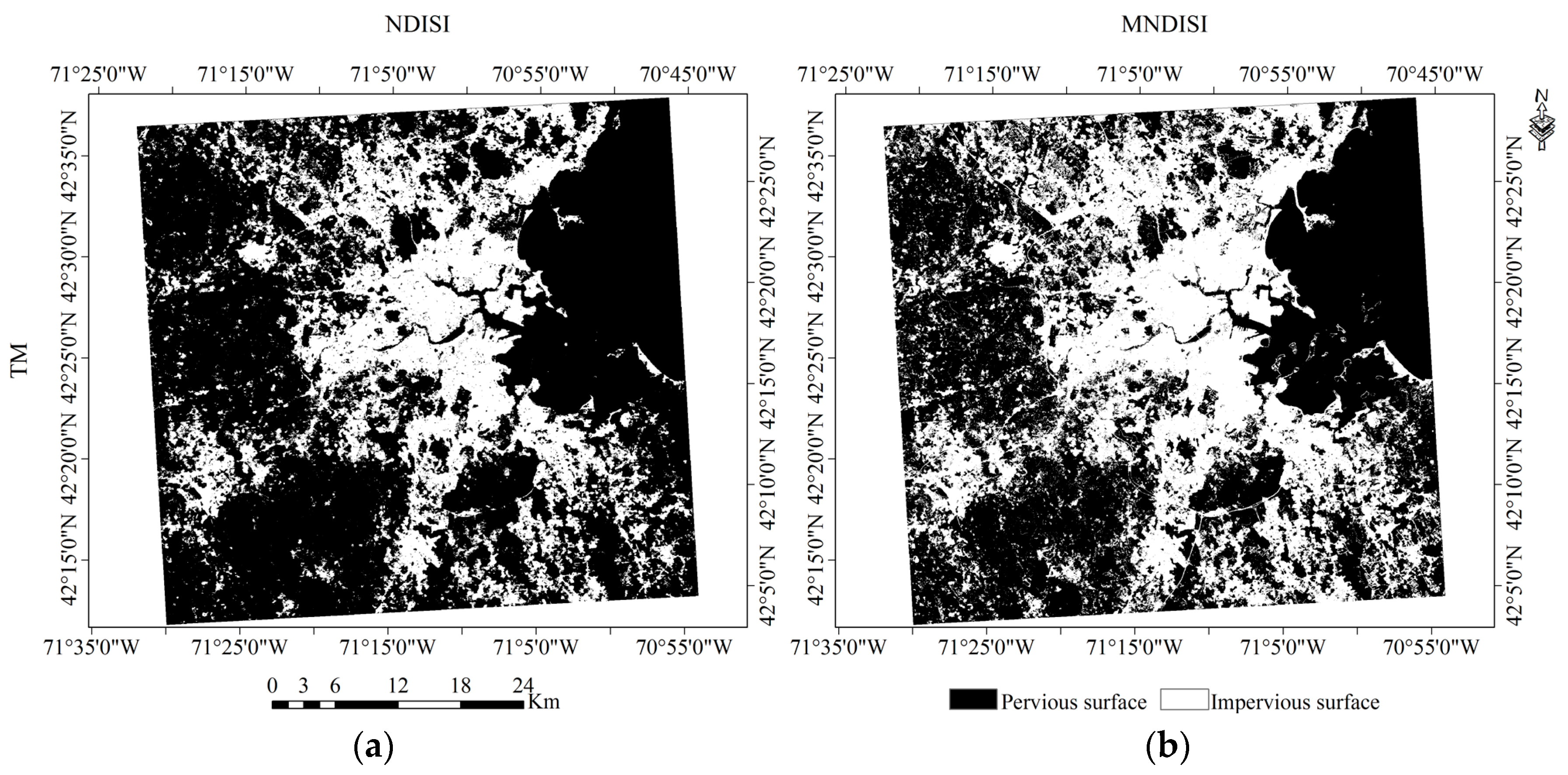
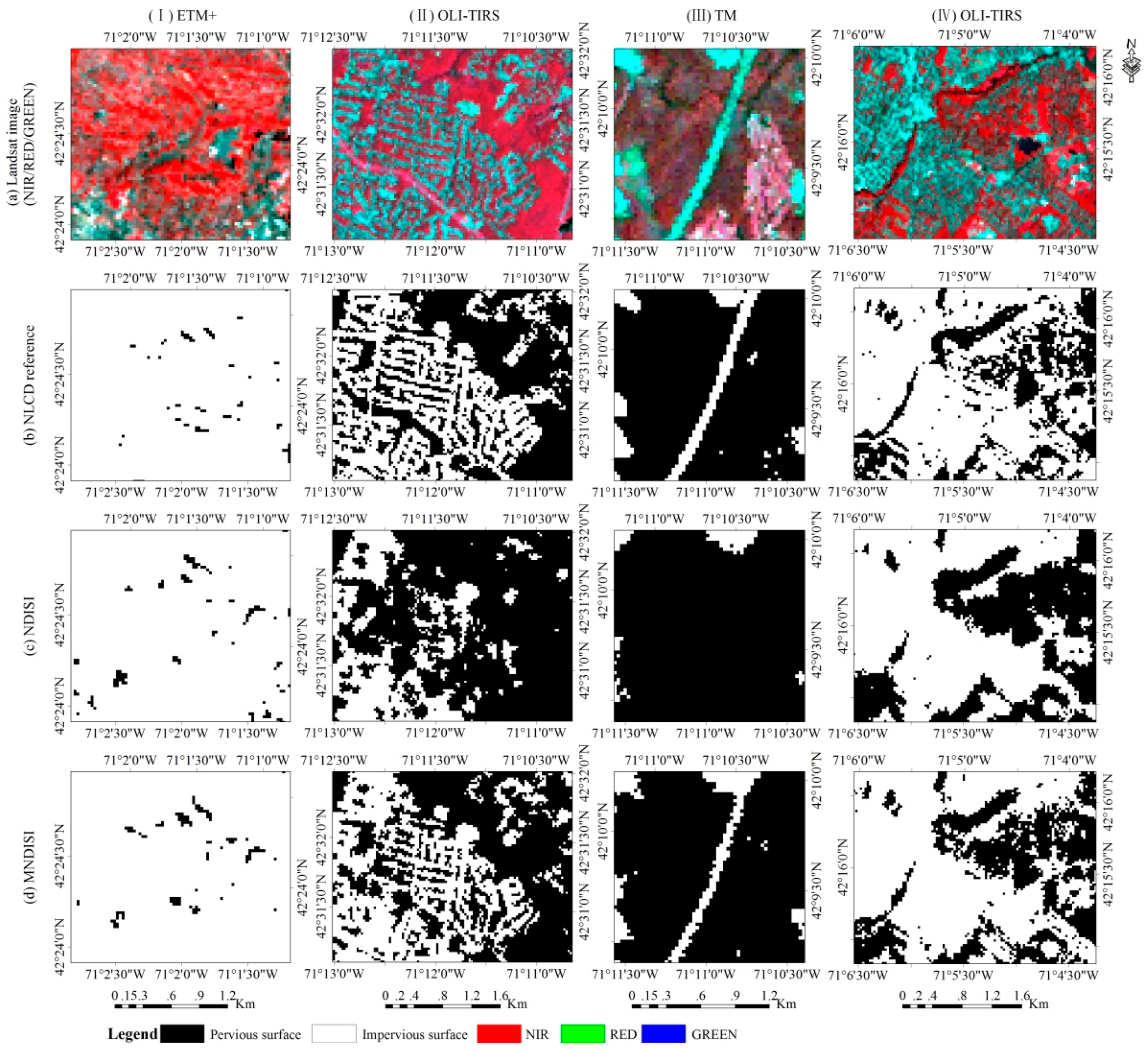
4.3.2. Visual Comparison
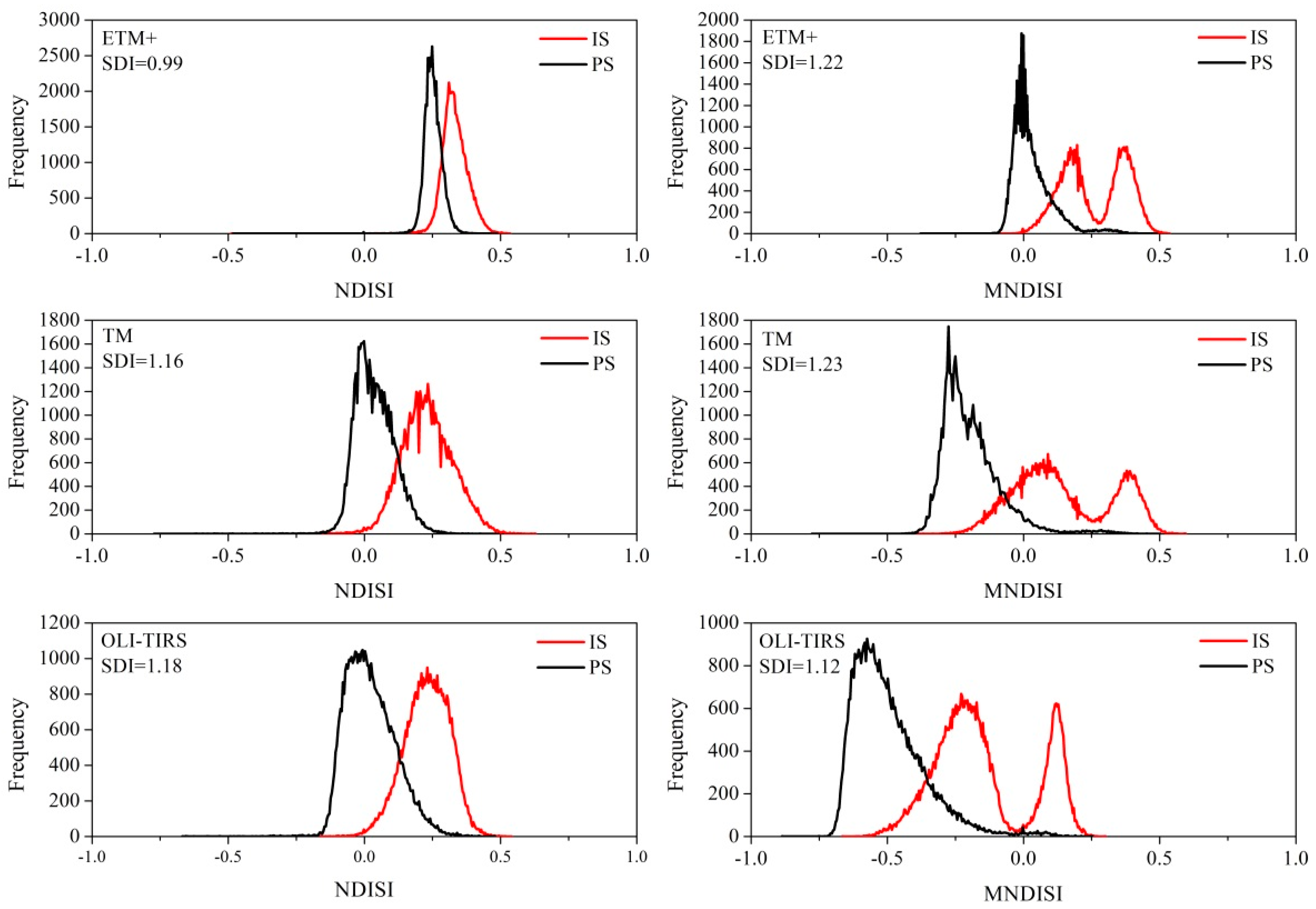
4.3.3. Statistical Comparison
4.3.4. Accuracy Assessment
5. Discussion
6. Conclusions
- (1)
- Our results show that built-up indices are sensitive to seasonal changes in urban environments; and imagery acquired in summer is the best for ISA mapping. The three Landsat sensors, TM, ETM+ and OLITIRS, do not have significant differences in extracting impervious surfaces.
- (2)
- By downscaling thermal information using green cover-related emissivity, the proposed MNDISI enhances urban features especially, for low density impervious surfaces. The OA and OK values derived from Landsat imagery of all three sensors are higher than 87% and 74%, respectively.
- (3)
- With the rich set of Landsat imagery from its multiple sensors in the past 40 years, the proposed MNDISI together with automatic threshold selection approach could become an efficient tool for rapid mapping of impervious surfaces at regional and global scales, and therefore provides vital information to study broad impacts of human activities across the globe.
Acknowledgments
Author Contributions
Conflicts of Interest
References
- Weng, Q.H. Remote sensing of impervious surfaces in the urban areas: Requirements, methods, and trends. Remote Sens. Environ. 2012, 117, 34–49. [Google Scholar] [CrossRef]
- Sun, Z.C.; Li, X.W.; Fu, W.X.; Li, Y.K.; Tang, D.S. Long-term effects of land use/land cover change on surface runoff in urban areas of Beijing, China. J. Appl. Remote Sens. 2014, 8, 084596. [Google Scholar] [CrossRef]
- Mathew, A.; Khandelwal, S.; Kaul, N. Spatial and temporal variations of urban heat island effect and the effect of percentage impervious surface area and elevation on land surface temperature: Study of Chandigarh city, India. Sustain. Cities Soc. 2016, 26, 264–277. [Google Scholar] [CrossRef]
- Melesse, A.M.; Weng, Q.; Thenkabail, P.S.; Senay, G.B. Remote sensing sensors and applications in environmental resources mapping and modelling. Sensors 2007, 7, 3209–3241. [Google Scholar] [CrossRef]
- Liu, Z.H.; Wang, Y.L.; Li, Z.G.; Peng, J. Impervious surface impact on water quality in the process of rapid urbanization in Shenzhen, China. Environ. Earth Sci. 2013, 68, 2365–2373. [Google Scholar] [CrossRef]
- Kim, H.; Jeong, H.; Jeon, J.; Bae, S. The impact of impervious surface on water quality and its threshold in Korea. Water 2016, 8, 111. [Google Scholar] [CrossRef]
- Touchaei, A.G.; Akbari, H.; Tessum, C.W. Effect of increasing urban albedo on meteorology and air quality of Montreal (Canada)—Episodic simulation of heat wave in 2005. Atmos. Environ. 2016, 132, 188–206. [Google Scholar] [CrossRef]
- Schneider, A.; Friedl, M.A.; Potere, D. A new map of global urban extent from MODIS satellite data. Environ. Res. Lett. 2009, 4, 044003. [Google Scholar] [CrossRef]
- Seto, K.C.; Fragkias, M.; Güneralp, B.; Reilly, M.K. A meta-analysis of global urban land expansion. PLoS ONE 2011, 6, e23777. [Google Scholar] [CrossRef] [PubMed]
- Sexton, J.O.; Song, X.P.; Huang, C.Q.; Channan, S.; Baker, M.E.; Townshend, J.R.G. Urban growth of the Washington, D.C.–Baltimore, MD metropolitan region from 1984 to 2010 by annual, Landsat-based estimates of impervious cover. Remote Sens. Environ. 2013, 129, 42–53. [Google Scholar] [CrossRef]
- Zhang, L.; Weng, Q.H. Annual dynamics of impervious surface in the Pearl River Delta, China, from 1988 to 2013, using time series Landsat imagery. ISPRS J. Photogramm. 2016, 113, 86–96. [Google Scholar] [CrossRef]
- Song, X.P.; Sexton, J.O.; Huang, C.Q.; Channan, S.; Townshend, J.R.G. Characterizing the magnitude, timing and duration of urban growth from time series of Landsat-based estimates of impervious cover. Remote Sens. Environ. 2016, 175, 1–13. [Google Scholar] [CrossRef]
- Yu, S.S.; Sun, Z.C.; Guo, H.D.; Zhao, X.W.; Sun, L.; Wu, M.F. Monitoring and analyzing the spatial dynamics and patterns of megacities along the Maritime Silk Road. J. Remote Sens. 2017, 21, 1993–2002. [Google Scholar] [CrossRef]
- Sun, Z.C.; Guo, H.D.; Li, X.W.; Lu, L.L. Estimating urban impervious surfaces from Landsat-5 TM imagery using multilayer perceptron neural network and support vector machine. J. Appl. Remote Sens. 2011, 5, 053501. [Google Scholar] [CrossRef]
- Taubenböck, H.; Esch, T.; Felbier, A.; Wiesner, M.; Roth, A.; Dech, S. Monitoring urbanization in mega cities from space. Remote Sens. Environ. 2012, 117, 162–176. [Google Scholar] [CrossRef]
- Franke, J.; Roberts, D.A.; Halligan, K.; Menz, G. Hierarchical multiple endmember spectral mixture analysis (MESMA) of hyperspectral imagery for urban environments. Remote Sens. Environ. 2009, 113, 1712–1723. [Google Scholar] [CrossRef]
- Deng, C.B.; Wu, C.S. A spatially adaptive spectral mixture analysis for mapping subpixel urban impervious surface distribution. Remote Sens. Environ. 2013, 133, 62–70. [Google Scholar] [CrossRef]
- Bauer, M.E.; Loffelholz, B.C.; Willson, B. Estimating and mapping impervious surface area by regression analysis of Landsat imagery. In Remote Sensing of Impervious Surfaces; Weng, Q.H., Ed.; Taylor & Francis Group, LLC: Boca Raton, FL, USA, 2008; pp. 3–19. [Google Scholar]
- Im, J.; Lu, Z.Y.; Rhee, J.; Quackenbush, L.J. Impervious surface quantification using a synthesis of artificial immune networks and decision/regression trees from multi-sensor data. Remote Sens. Environ. 2012, 117, 102–113. [Google Scholar] [CrossRef]
- Yang, L.M.; Huang, C.Q.; Homer, C.G.; Wylie, B.K.; Coan, M.J. An approach for mapping large-area impervious surfaces: Synergistic use of Landsat 7 ETM+ and high spatial resolution imagery. Can. J. Remote Sens. 2003, 29, 230–240. [Google Scholar] [CrossRef]
- Lu, D.S.; Moran, E.; Hetrick, S. Detection impervious surface change with multitemporal Landsat images in an urban-rural frontier. ISPRS J. Photogramm. Remote Sens. 2011, 66, 298–306. [Google Scholar] [CrossRef] [PubMed]
- Xu, H. Analysis of impervious surface and its impact on urban heat environment using the normalized difference impervious surface index (NDISI). Photogramm. Eng. Remote Sens. 2010, 76, 557–565. [Google Scholar] [CrossRef]
- Sun, G.Y.; Chen, X.L.; Jia, X.P.; Yao, Y.J.; Wang, Z.J. Combinational build-up index (CBI) for effective impervious surface mapping in urban areas. IEEE J. Sel. Top. Appl. Earth Obs. Remote Sens. 2016, 9, 2081–2092. [Google Scholar] [CrossRef]
- Deng, C.B.; Wu, C.S. BCI: A biophysical composition index for remote sensing of urban environments. Remote Sens. Environ. 2012, 127, 247–259. [Google Scholar] [CrossRef]
- Lu, D.S.; Li, G.Y.; Kuang, W.H.; Moran, E. Methods to extract impervious surface areas from satellite images. Int. J. Digit. Earth 2014, 7, 93–112. [Google Scholar] [CrossRef]
- Xu, H.Q.; Wang, M.Y. Remote sensing-based retrieval of ground impervious surfaces. J. Remote Sens. 2016, 20, 1270–1289. [Google Scholar] [CrossRef]
- Kawamura, M.; Jayamana, S.; Tsujiko, Y. Relation between social and environmental conditions in Colombo Sri Lanka and the urban index estimated by satellite remote sensing data. Int. Arch. Photogramm. Remote Sens. 1996, 31, 321–326. [Google Scholar]
- Carlson, T.N.; Arthur, S.T. The impact of land use-land cover changes due to urbanization on surface microclimate and hydrology: A satellite perspective. Glob. Planet. Chang. 2000, 25, 49–65. [Google Scholar] [CrossRef]
- Zha, Y.; Gao, Y.; Ni, S. Use of normalized difference built-up index in automatically mapping urban areas from TM imagery. Int. J. Remote Sens. 2003, 24, 583–594. [Google Scholar] [CrossRef]
- Xu, H.Q. A new index for delineating built-up land features in satellite imagery. Int. J. Remote Sens. 2008, 29, 4269–4276. [Google Scholar] [CrossRef]
- Ma, Y.; Kuang, Y.Q.; Huang, N.S. Coupling urbanization analyses for studying urban thermal environment and its interplay with biophysical parameters based on TM/ETM+ imagery. Int. J. Appl. Earth Obs. 2010, 12, 110–118. [Google Scholar] [CrossRef]
- As-Syakur, A.R.; Adnyana, I.; Arthana, I.W.; Nuarsa, I.W. Enhanced built-up and bareness index (EBBI) for mapping built-up and bare land in an urban area. Remote Sens. 2012, 4, 2957–2970. [Google Scholar] [CrossRef]
- Liu, C.; Shao, Z.F.; Chen, M.; Luo, H. MNDISI: A multisource composition index for impervious surface area estimation at the individual city scale. Remote Sens. Lett. 2013, 4, 803–812. [Google Scholar] [CrossRef]
- Zhou, Y.; Yang, G.; Wang, S.X.; Wang, L.T.; Wang, F.T.; Liu, X.F. A new index for mapping built-up and bare land areas from Landsat-8 OLI data. Remote Sens. Lett. 2014, 5, 862–871. [Google Scholar] [CrossRef]
- Wang, Z.Q.; Gang, C.C.; Li, X.L.; Chen, Y.Z.; Li, J.L. Application of a normalized difference impervious index (NDII) to extract urban impervious surface features based on Landsat TM images. Int. J. Remote Sens. 2015, 36, 1055–1069. [Google Scholar] [CrossRef]
- United States Census Bureau. Population and Housing Occupancy Status: 2010-State-County Subdivision, 2010-State-County Subdivision, 2010 Census Redistricting Data (Public Law 94-171) Summary File. Available online: https://www.census.gov/prod/cen2010/doc/pl94-171.pdf (accessed on 15 February 2017).
- National Oceanic and Atmospheric Administration (NOAA). Now Data—NOAA Online Weather Data. Available online: http://w2.weather.gov/climate/xmacis.php?wfo=box (accessed on 15 February 2017).
- Richter, R.; Schläpfer, D. Atmospheric/Topographic Correction for Satellite Imagery: ATCOR-2/3 User Guide, DLR-IB 565-01/15; German Aerospace Center: Wessling, Germany, 2015. [Google Scholar]
- U.S. Geological Survey (USGS). Landsat 8 (L8) Data Users Handbook. Available online: https://landsat.usgs.gov/landsat-8-l8-data-users-handbook (accessed on 10 February 2017).
- Homer, C.G.; Dewitz, J.A.; Yang, L.; Jin, S.; Danielson, P.; Xian, G.; Coulston, J.; Herold, N.D.; Wickham, J.D.; Megown, K. Completion of the 2011 National Land Cover Database for the conterminous United States-Representing a decade of land cover change information. Photogramm. Eng. Remote Sens. 2015, 81, 345–354. [Google Scholar] [CrossRef]
- Chander, G.; Markham, B.L.; Helder, D.L. Summary of current radiometric calibration coefficients for Landsat MSS, TM, ETM+, and EO-1 ALI sensors. Remote Sens. Environ. 2009, 113, 893–903. [Google Scholar] [CrossRef]
- Xu, H.Q. Modification of normalized difference water index (NDWI) to enhance open water features in remotely sensed imagery. Int. J. Remote Sens. 2006, 27, 3025–3033. [Google Scholar] [CrossRef]
- Sobrino, J.A.; Jiménez-Muñoz, J.C.; Sòria, G.; Romaguera, M.; Guanter, L.; Moreno, J.; Plaza, A.; Martínez, P. Land surface emissivity retrieval from different VNIR and TIR sensors. IEEE Trans. Geosci. Remote Sens. 2008, 46, 316–327. [Google Scholar] [CrossRef]
- Weng, Q.H.; Lu, D.S.; Schubring, J. Estimation of land surface temperature–vegetation abundance relationship for urban heat island studies. Remote Sens. Environ. 2004, 89, 467–483. [Google Scholar] [CrossRef]
- Bazi, Y.; Bruzzone, L.; Melgani, F. An Unsupervised Approach Based on the Generalized Gaussian Model to Automatic Change Detection in Multitemporal SAR Images. IEEE Trans. Geosci. Remote Sens. 2005, 43, 874–887. [Google Scholar] [CrossRef]
- Li, X.W.; Zhang, L.; Guo, H.D.; Sun, Z.C.; Liang, L. New approaches to urban area change detection using multitemporal RADARSAT-2 polarimetric synthetic aperture radar (SAR) data. Can. J. Remote Sens. 2012, 38, 253–266. [Google Scholar] [CrossRef]
- Kittler, J.; Illingworth, J. Minimum error thresholding. Pattern Recognit. 1986, 19, 41–47. [Google Scholar] [CrossRef]
- Sharifi, K.; Leon-Garcia, A. Estimation of shape parameter for generalized Gaussian distributions in subband decomposition of video. IEEE Trans. Circuits Syst. Video Technol. 1995, 5, 52–56. [Google Scholar] [CrossRef]
- Congalton, R.G. A review of assessing the accuracy of classifications of remotely sensed data. Remote Sens. Environ. 1991, 37, 35–46. [Google Scholar] [CrossRef]
- Foody, G.M. Status of land cover classification accuracy assessment. Remote Sens. Environ. 2002, 80, 185–201. [Google Scholar] [CrossRef]
- Kaufman, Y.J.; Remer, L.A. Detection of forests using mid-IR reflectance: An application for aerosol studies. IEEE Trans. Geosci. Remote Sens. 1994, 32, 672–683. [Google Scholar] [CrossRef]
- Pereira, J.M. A comparative evaluation of NOAA/AVHRR vegetation indexes for burned surface detection and mapping. IEEE Trans. Geosci. Remote Sens. 1999, 37, 217–226. [Google Scholar] [CrossRef]
- Deng, Y.B.; Wu, C.S.; Li, M.; Chen, R.R. RNDSI: A ratio normalized difference soil index for remote sensing of urban/suburban environments. Int. J. Appl. Earth Obs. Geoinf. 2015, 39, 40–48. [Google Scholar] [CrossRef]
- Li, H.; Wang, C.; Zhong, C.; Su, A.; Xiong, C.; Wang, J.; Liu, J. Mapping urban bare land automatically from Landsat imagery with a simple index. Remote Sens. 2017, 9, 249. [Google Scholar] [CrossRef]
- Piyoosh, A.K.; Ghosh, S.K. Development of a modified bare soil and urban index for Landsat 8 satellite data. Geocarto Int. 2017, 1, 1–20. [Google Scholar] [CrossRef]
- Guo, H.D.; Yang, H.N.; Sun, Z.C.; Li, X.W.; Wang, C.Z. Synergistic Use of Optical and PolSAR Imagery for Urban Impervious Surface Estimation. Photogramm. Eng. Remote Sens. 2014, 80, 91–102. [Google Scholar] [CrossRef]
- Esch, T.; Marconcini, M.; Felbier, A.; Heldens, W.; Huber, M.; Schwinger, M.; Taubenböck, H.; Müller, A.; Dech, S. Urban footprint processor—Fully automated processing chain generating settlement masks from global data of the TanDEM-X mission. IEEE Geosci. Remote Sens. Lett. 2013, 10, 1617–1621. [Google Scholar] [CrossRef] [Green Version]
- Ban, Y.F.; Jacob, A.; Gamba, P. Spaceborne SAR data for global urban mapping at 30 m resolution using a robust urban extractor. ISPRS J. Photogramm. Remote Sens. 2015, 103, 28–37. [Google Scholar] [CrossRef]



| Satellite | Sensor | Acquisition Date | Resolution (m) | Wavelength (μm) |
|---|---|---|---|---|
| Landsat-5 | TM | 24 April 2010 (spring) 30 August 2010 (summer) 5 November 2011 (autumn) 5 January 2011 (winter) | 30 | Band1 (Blue): 0.441–0.514 |
| Band2 (Green): 0.519–0.601 | ||||
| Band3 (Red): 0.631–0.692 | ||||
| Band4 (NIR): 0.772–0.898 | ||||
| Band5 (SWIR-1): 1.547–1.749 | ||||
| 120 | Band6 (TIR): 10.31–12.36 | |||
| 30 | Band7 (SWIR-2): 2.064–2.345 | |||
| Landsat-7 | ETM+ | 23 April 2001 (spring) 29 August 2001 (summer) 17 November 2001 (autumn) 1 January 2001 (winter) | 30 | Band1 (Blue): 0.441–0.514 |
| Band2 (Green): 0.519–0.601 | ||||
| Band3 (Red): 0.631–0.692 | ||||
| Band4 (NIR): 0.772–0.898 | ||||
| Band5 (SWIR-1): 1.547–1.749 | ||||
| 60 | Band6 (TIR): 10.31–12.36 | |||
| 30 | Band7 (SWIR-2): 2.064–2.345 | |||
| 15 | Band8 (Pan): 0.515–0.896 | |||
| Landsat-8 | OLI-TIRS | 24 April 2016 (spring) 13 July 2016 (summer) 30 October 2015 (autumn) 30 January 2016 (winter) | 30 | Band1 (Coastal/Aerosol): 0.435–0.451 |
| Band2 (Blue): 0.452–0.512 | ||||
| Band3 (Green): 0.533–0.590 | ||||
| Band4 (Red): 0.636–0.673 | ||||
| Band5 (NIR): 0.851–0.879 | ||||
| Band6 (SWIR-1): 1.566–1.651 | ||||
| Band7 (SWIR-2): 2.107–2.294 | ||||
| 15 | Band8 (Pan): 0.503–0.676 | |||
| 30 | Band9 (Cirrus): 1.363–1.384 | |||
| 100 | Band10 (TIR-1): 10.60–11.19 | |||
| Band11 (TIR-2): 11.50–12.51 |
| Built-up Indices | Accuracy Measures | TM | ETM+ | OLI-TIRS |
|---|---|---|---|---|
| NDISI | OA (%) | 84.64 | 85.77 | 84.19 |
| OK | 0.69 | 0.71 | 0.68 | |
| MNDISI | OA (%) | 89.35 | 87.19 | 87.52 |
| OK | 0.79 | 0.74 | 0.75 | |
| Improvement (MNDISI − NDISI) | OA (%) | 4.71 | 1.42 | 3.33 |
| OK | 0.10 | 0.03 | 0.07 |
© 2017 by the authors. Licensee MDPI, Basel, Switzerland. This article is an open access article distributed under the terms and conditions of the Creative Commons Attribution (CC BY) license (http://creativecommons.org/licenses/by/4.0/).
Share and Cite
Sun, Z.; Wang, C.; Guo, H.; Shang, R. A Modified Normalized Difference Impervious Surface Index (MNDISI) for Automatic Urban Mapping from Landsat Imagery. Remote Sens. 2017, 9, 942. https://doi.org/10.3390/rs9090942
Sun Z, Wang C, Guo H, Shang R. A Modified Normalized Difference Impervious Surface Index (MNDISI) for Automatic Urban Mapping from Landsat Imagery. Remote Sensing. 2017; 9(9):942. https://doi.org/10.3390/rs9090942
Chicago/Turabian StyleSun, Zhongchang, Cuizhen Wang, Huadong Guo, and Ranran Shang. 2017. "A Modified Normalized Difference Impervious Surface Index (MNDISI) for Automatic Urban Mapping from Landsat Imagery" Remote Sensing 9, no. 9: 942. https://doi.org/10.3390/rs9090942
APA StyleSun, Z., Wang, C., Guo, H., & Shang, R. (2017). A Modified Normalized Difference Impervious Surface Index (MNDISI) for Automatic Urban Mapping from Landsat Imagery. Remote Sensing, 9(9), 942. https://doi.org/10.3390/rs9090942


