Abstract
The ‘wadis’ (ephemeral incised channels in arid regions) concern badlands with low agriculture utilisation that expands to neighbouring cultivated areas. They are noticeable and unique landforms characterised by vegetation patches and seasonal flood flows with scenic beauty that must be conserved. The wadi characteristics have influenced the way of life of their indigenous residents from ancient times until now. The main one is grazing with small ruminants (SR). The authorities and public consider grazing in these areas as a destructive land management practice that should be reduced. To assess the viability of grazing in such regions, we hypothesised that fluvial and biological flows tightly correlate with the wadis’ landforms, channels and slopes. The site of study is located in the Yeroham mountains nearby the Rahma planned Bedouin village. Five different transects of channels and slopes were located over representative wadis, including those exposed to grazing. The finding indicates that a herbaceous vegetation expansion uphill was observed only in grazed transects, while the wadi slope patterns affect its patterns. It contains an increased soil water content (from a similar value of 5% until 13% change in the grazed transect), 1.5% higher soil organic matter, 0.08 mg Kg−1 higher Nitrite content and 1–2% higher clay content in the grazed transects, up to 4 m ahead from the channel. The novelty of this finding suggested that the SR influences the organic matter to reach the wadi channel and facilitate the adherence of aggregated clay and the formed colluvial layer that serves as a substrate to the expanded vegetation growth. Adequate implementation of these grazing patterns may rehabilitate degraded ‘wadis’ and increase their tourism eligibility.
Highlights
- The liquid excretion of SR enriches the wadis’ slopes with Nitrogen and Phosphorus;
- The digested droppings of the SR enriches the slopes with organic matter;
- The organic matter from the SR excretion forms a colluvial layer on wadi channel banks;
- Planned and managed SR grazing may be used as a land management tool for wadis’ area.
1. Introduction
The landforms of the Negev Highland represent a highly incised area with a dense net of wadis. The region is rich in wadi channels segmenting the soil surface. The flow in the wadis is characterised by flash floods due to convectional rainfall events [1]. Geomorphologically, the wadi is the last phase of the gully erosional process, as follows: rill, gully (in initial and then in the stabilised state), and finally the wadi [2]. In the dry Mediterranean regions and the Arab Peninsula, the wadis’ area, occupying a total area of >2 million km2, is laid mostly over loamy deposits or limestone [3]. The wadis’ area is settled by indigenous residents, mostly from previously nomadic tribes, termed ‘Bedouin’. A wide part of the Bedouin residents deals with traditional agricultural practices as grazing, mostly small ruminant (SR) and camels, and rain-fed crop breeding. The wadi area is characterised by the existence of highly eroded landforms embedded between the channels as loessial plains, salty plains and rocky grounds, all of which are tightly connected to the existing wadis [4]. The integration of the unique three-dimensional shape of the wadis, an arid climate with short-termed but intensified rainfall events, reduced vegetation coverage and thin soil layer has led to flood creation (Figure S2). The floods result in a massive removal and transport of soil sediments out from the system, leading to rocky karst desertification. As an actively segmented landform, the size of the wadi has been rapidly widened, enlarged and branched out due to the pedology process, caused mostly by the implementation of inadequate land management practices and agriculture cultivations in its surrounding area. These geomorphological changes lead, in the end, to a reduced agriculture utilisation. In such areas, grazing has been considered as unsuitable management due to its negative influences on the plant’s community, composition, size and abundance (e.g., [5,6,7]). Nevertheless, in preliminary surveys over the wadis’ areas in the Negev Highland, we noticed that the vegetation coverage over the sloped banks, located in the grazed area, is higher than in the ungrazed area. These observations were documented by [8]. Therefore, we hypothesised that such phenomena might be explained by integrating factors related to the wadi channel and slope’s geographic outlines, grazing, soil type, vegetation cover and grazing management. The following objectives were defined for the study: (i) determining the geomorphological factors influencing the wadis’ fertility, (ii) determining the spatial grazing patterns in the wadis area and (iii) determining the influence of SR grazing on the fertile material flows and herbaceous biomass coverage over the wadi landforms and its topography. Intensifying the fertile material flows between the wadi landforms may additionally enhance the rehabilitation of the neighbouring areas, due to the tight connectivity between them and the wadi [4,9].
2. Material and Methods
2.1. Site of Study
The site of study is located in the western hills of Yeroham valley, in the Negev Highland (31°02′5.8″ N, 34°55′43″ E, 500 M.S.L). The area is so densely covered by wadis that their 1st order unit is confluent with the Yeroham ephemeral stream in its western bank. In the preliminary survey, which is briefly described by [8], we noticed the uniqueness of wadi banks, in which its area has been differently grazed, while parts are exposed to grazing and others enclosed due to intertribal agreements and those with the municipalities. Its channel is characterized by a wide range of incision phenomena and different slotted soil profiles (limestone and loessial layer).
The channel to 200 m uphill is covered by ruins of ancient stone dams, possibly correlated to the agriculture terraces adjacent to ancient facilities ruins, forming a water harvesting system [10]. The dams, agriculture terraces and the facilities were dated by the Israel Antique authorities to have been intensively agricultural utilised in the Byzantine era 324–638AD. Parts from the areas are still used today as pasture lands for SR and camels, herds belonging to the Rahma Bedouin village farmers ([8]). The site’s bedrock is limestone with a regolith layer, 0.1–1 m thick, integrated with fluvial/colluvial reworked (or partially reworked) loess mostly from fluvial activity [11]. The area is covered by a regolith arid regions vegetation [12,13] from the following species [14]: Malva sylvestris, Anthemis melampodina, Moricandia nitens, Thymelaea hirsute, Zygophyllum dumosum, Anabasis articulata, Onopordum palaestinum, Drimia maritima and species that correlated to previous cultivated species, such as Hordeum spontaneum and Triticum aestivium. The common shrubs are Retama raetam, Suaeda vera and Eremopyrum bonaepartis. Hereby, the wadis will be termed wadis of study (WOS). A demonstration one of the WOS sites and the surrounding area is presented in Figure 1.
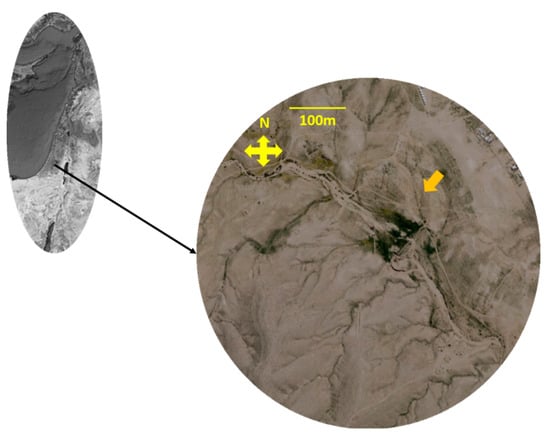
Figure 1.
The location of the area of the study circle—Rahma site of study. The orange arrow shows the wadi of study (WOS) (source: Google Earth).
Over the WOS, five different transacts with slopes larger than 20 m were located mostly in the wadi south bank based on grazing patterns (with grazing and without—the ungrazed transect was inaccessible to the animals due to the geographic outlines of its surroundings), on different channel flow directionality, straight and curved plots. In the curved plot, the outward and inward slopes were studied separately [4] and over slopes with different pedology. The characters of the different transects are presented in Figure 2 and Table 1.
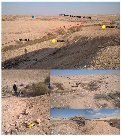
Figure 2.
Wadi of study (WOS) and the analysed transects. (A) Far view of WOS. Red line: channel with ancient dams, blue line: ancient agriculture terrace over Yeroham ephemeral stream, blue rectangle—ancient facility (all were dated by an expert to the Byzantine era). (B) Slope 1, (C) slopes 2, 3, (D) slope 4, (E) slope 5.

Table 1.
Analyzed transects over WOS.
2.2. Determining the Grazing Patterns of the Area
The grazing patterns were determined after inquiring with Rahma herd owners. The data include the common grazed herds’ size, composition, species (goat, sheep or camels) (Figure S1) and types, grazing locations and timing during the year, in addition to data that were collected from the scientific literature and in-field analysis following the grazers droppings [15].
2.3. Determining the Evolution of Geographical and Geomorphological Outlines
Unlike other landforms, characterising the wadi’s area is highly challenging due to its unique spatial shape and the ongoing incision processes that are consistently affecting its characters. Therefore, three orthophotos of the site of study from 2012, 2016 and 2020 were analysed to assess the changes, wadis and gullies’ elongation, widening and branching, determining the intensity of soil erosion by comparison of rocky slopes size and finally changes of shrubbery changes that resemble the ecological functioning of the area [4].
2.4. Locating the Sampling Plots over the Transect
To determine the spatial dynamic of soil moisture content, organic matter and nutrients over the different parts, channels and slopes of each analysed transect and to compare between the different transect patterns, a unique measurement and analysis scheme was designed, which is based on [16] sampling principles, as follows. Per each transect, five contours were defined: channel, 1 m up-slope, 2 m, 3 m, 4 m, 5.5 m. In the field, to ease the measurement, we marked the location of each contour with orange plastic balls over rope laid from the channel. In each contour, four plots were sampled for the herbaceous biomass weight (HBW), soil water content (SWC), soil organic matter (SMC) and three for nitrite and granular content (Figure 3)
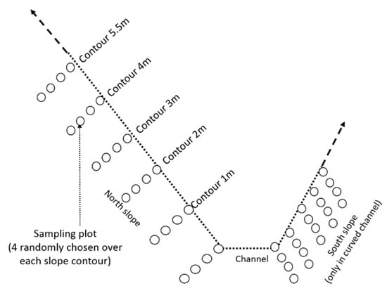
Figure 3.
Sampling scheme of herbaceous biomass and soil over the WOS transects.
2.5. Soil Properties Measurements
The soil sampling was carried out by digging out soil mix from surface until 15 cm depth; the root system zone of annuals in arid areas [17] and the herbaceous biomass were harvested using a 25 × 25 cm iron frame based on [18] sampling procedure. An ANOVA (analysis of variance) test was carried out on each fertility property, in such a manner that each transect contour serves as a standalone treatment. The significance of the difference was determined using JMP Pro® ver. 14, with α = 0.1. The measurements procedures are summarised in Table 2.
Table 2.
The physical, chemical and vegetal measurements were carried out in the study.
3. Results
3.1. Grazing Patterns
Two grazing species are common in the area: camels (singles or groups) and SR herds. The camels (Camelus dromedaries) mostly graze in the flooded and loess plains. Nevertheless, due to recent national regulations that highly limit camel grazing in the Negev Highland (Degen et al., 2019), the Bedouin knit camel groups in predefined plots over the pastoral lands and separate them from the SR. Nevertheless, a recent study claims that these animals’ different vegetation consumption patterns can be co-grazed (e.g., Mohammed et al., 2020). The plains between the wadis are generally sowed with cereal (mostly barely) animal feedings. The herds in Negev Highland are primarily bred due to traditional reasons and not for commercial purposes, as in the other Israel regions. Although the local herd owners claim that the Jabali type is the dominant type, the dominant goats’ type is the Baladi, which was possibly crossbred in the previous generation with the Jabali type [19]. The sheep belong to the Awasi type, characterised by a diverse range of shapes and behavioural patterns. The SRs are bred primarily for meat production and are sold young, three months old, to save on feeding expenses (over the other parts of Israel, the typical selling age is six months). The flock size is small compared with the sizes in other regions in Israel, containing 10–50 animals with similar rates of sheep and goats younger than 3 months. The number of grazing sessions depends on pasture state, mostly between February and June.
To define the spatial distribution scheme of the SR over the wadi, we used two methodologies: detailed questioning of Rahma village herd owners [20], and analysing their dropping location [21]. The findings indicate that three spatial distribution schemes of the SR in the wadis were defined as follows: distributed, route and centralised. The distributed pattern is characterised by a homogenous spreading of the animals observed in floodplains and flat areas, which resembles free grazing over the area. The route pattern resembled the state of the herd transportation by a shepherd or leading animal [8,22]. This type was primarily observed in steep wadi slopes. The centralised pattern was observed surrounding ‘hot spot’ such as shrubs, e.g., Retama raetam, which supply food and shading [23] and highly productive vegetation patches (Figure 4).
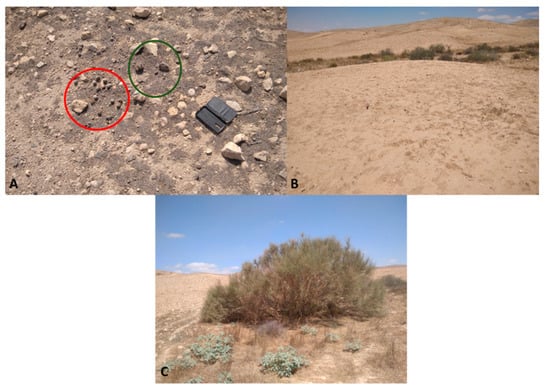
Figure 4.
Dropping types and concluded animal distribution from the WOS (2/2021). (A) Camels and small ruminant droppings; (B) homogenous distribution; (C) Retama raetam with high droppings in its surrounding.
3.2. The Evolution of Geography, and Geomorphology of the Area
Comparison of orthophotos from the last decade (2012 until 2020) reveals several trends, as marked in Figure 5 by representative plots, as follows: 1—the dynamic of shrubbery establishment in the confluent of the eastern gully with the Yeroham channel estuary; 2—the dynamic of wadi incision from the narrow gully into the sandy wadi; 3—vegetation establishment in wadi winding; 4—incision dynamic: formation of rills and gullies in the loess plain.
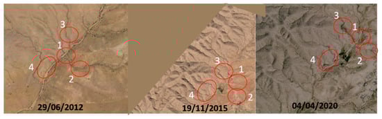
Figure 5.
Geomorphological and vegetal changes of the site of study in the last decade (2012, 2015, 2020).
3.3. Influence of the Geographic Outlines of Wadi on Its Herbaceous Coverage
In general, the herbaceous biomass weight (HBW) over the studied transects was low, possibly due to the low rainfall amounts (Figure 2), nevertheless, several trends can be defined based on the geographical outlines of the wadi and its channel, as follows.
The highest HBW was found in the plots located in the lower part of the channel, which is additionally wide and dammed. The wadi channel in the inward part of the curved plot was higher compared with the outward one. Nevertheless, both were less than the one on the straight channel (Figure 6A). The slope incline influenced the HBW distribution over it, while in the steepest one (Transect 1 and 2), an exponential decrease was found from the channel upslope; in the light one, a linear decrease was found (Figure 6B).
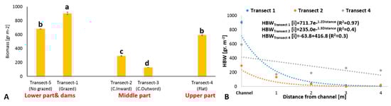
Figure 6.
The herbaceous biomass weight in the different wadi plots. (A) The herbaceous biomass weight in the channel of the different transects; (B) the biomass weight distribution over the southern grazed transects. Lines on the graph: mean ± SE, C—curved channel, statistics: ANOVA, α = 0.1, a—highest grade, b and c—intermediate and d—lowest grade.
Along the outward transect of the curved channel plot, no vegetation was found this year. Nevertheless, a higher soil organic matter content (SOM) and soil moisture content (SMC) were found along it compared with the ‘Inward’ slope (Figure 7). In addition, the SOM and SMC increased, moving away from the channel.
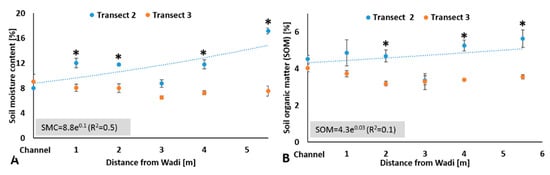
Figure 7.
The soil organic matter and moisture content over the slopes of the inward and outward parts of the curved plot. (A) Soil moisture content, (B) soil organic matter; Transect 2—outward part, Transect 3—inward part. Lines on columns/graph: mean ± SE, Statistics: t-test (comparison of values located in the similar contour of transects), *—Significant.
3.4. Influence of Grazing on Wadi Slopes on Soil Properties
Transects 2 (grazed) and 5 (ungrazed) were chosen for studying the influence of grazing on slopes due to their similar pedology, channel and slopes’ geographic outlines. The grazed transect lacked herbaceous cover, probably due to the drought. Nevertheless, differences were found between the slopes regarding their fertility. Furthermore, twice higher soil moisture (Figure 8A) and 1% higher soil organic matter content (Figure 8B) were found in comparison with the ungrazed slope. In addition, a higher nitrite content was found in the grazed transect (Figure 8C). Two percent higher clay content was found in the grazed slope, from channel banks until 4 m upslope, compared with the ungrazed slope (one exception found in the 3 m contour of the grazed, which can be explained by the influence of significant rock existence [24].
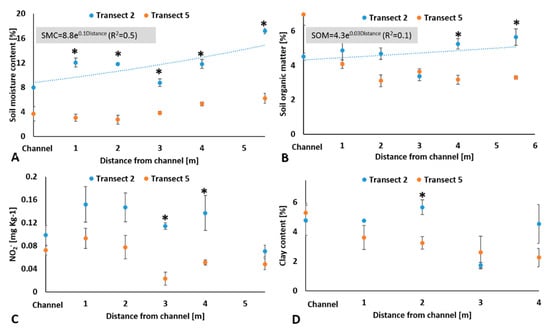
Figure 8.
The influence of grazing over wadi slopes on soil properties. (A) Soil moisture content, (B) soil organic matter, (C) nitrite content (N-NO2−), (D) clay content. Lines on columns/graph: mean ± SE, statistics: ANOVA (comparison of values located in the similar contour of transects), *—significant (α = 0.1).
4. Discussion
4.1. The Interrelation between Grazing and Wadi’s Fertility
Many parameters affect the urine and dropping amounts of small ruminants including, age, species and physiological state, but mostly the dietary state. Nevertheless, in a flattened area without inside or outside flows, the SR droppings, enriched the soil with phosphorus up to 50% from the intake [25], while urine enriched the soil by 50% nitrogen from the intake [26]. As opposed to the flattened terrestrial ecosystem in the wadis and gullies, the geographic outlines critically influence the ecosystem function and the ‘common’ ecosystem factors such as water and nutrient contents [4,5]. These geographic outlines can be conceptually separated into the wadi channel and its slopes. The interrelation between these parts affects the water, and biomaterial flows in the channel and between the wadi and its neighbored areas [3].
This interrelation was documented in the soil fertility study in curved channel plots and one of their slopes (Figure 7), and the fertility interrelations between the transect location over the channel and the herbaceous distribution over the slopes (Figure 6). In addition to the spatial channel shape, an additional factor must be considered to the existence of ancient Byzantine terraces over the channel [27,28].
The study finding additionally indicates that SR grazing, which is carried out on the wadi slopes, influences the ecological functioning of the whole wadi. Trampling, vegetation harvesting and spreading excrement are how ruminants interact with the ecosystem [29]. Therefore, the finding of this study has to be analysed regarding these means. Our primary surveys indicated that the herb’s weight was low, possibly due to the low rainfall amounts in the 2020–2021 season, which prevents their harvesting by the grazing animals [30]. Therefore, this means that it will be neglected here. The ecological functioning of the wadi due to grazing can be described as follows (Figure 9). The initial ecological feedback loop of the wadi channel [4] was intensified by ancient dams [27]. The SR excretions over the wadi slopes enriched the slope’s soil with nitrogen (Figure 8C) and possibly phosphorus compounds [31]. The animals’ solid excretions were contributed to soil organic matter and soluble nutrients, while the animals’ trampling enhanced these processes [32].
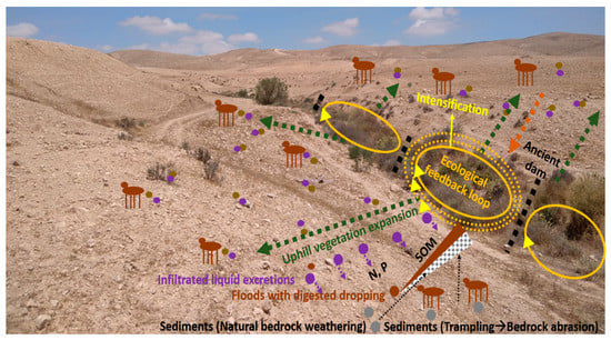
Figure 9.
The proposed interrelation between the channel spatial patterns, the small ruminant excretion and trampling and the resulting land rehabilitation in the wadi (Transect 1). Brown circle—animal dropping; purple circle—animal fluid excretion; grey circles—sediments.
The organic matter flooded into the channel edges brings fine particles to a buildup and to adhesion and abrasion caused by the animal trampling [33], due to the natural bedrock weathering process [34], forming a colluvial layer [35], as documented in Figure 8D. This colluvial layer, enriched in organic matter nutrients and high moisture content, is expanded upslope, resulting in a vegetation expansion upslope (Figure 6B). A similar process was documented previously in another landform, expressing the area rehabilitation.
4.2. Suggestions for In-Field Implementation
To intensify the rehabilitation processes in the wadis’ areas previously described, one should consider the herd owner’s mental patterns and the herding patterns of the SR in the wadis’ area [29,36]. Our preliminary meetings with Rahma Bedouin herd owners noticed that their attitude for herding is a hobby or, more accurately, a traditional occupation without profits. This attitude leads to low awareness of the ecological state of the pastureland of the wadis’ area [8]. Therefore, one of the study’s main goals is to build with the herd owners a profitable scheme for SR breeding, and to design ecological herding management for the wadis’ area for a long-term view for the area rehabilitation [36].
The herding scheme in the wadis’ area should rely on the patterns described in Section 4.1, considering the grazing as a manure management tool [37], with influence on the whole wadi area. The old Bedouin herd owners are known as experienced bellwether SR trainers [38]; therefore, based on their contribution, it is possible to use the three herding patterns (distributed, route and centralised) as suggested for the wadi ecological rehabilitation, which may be used for a suitable herding scheme [39].
The novelty of this study is the determination of interrelations between an “imported ecosystem engineer”—the grazers, the wadi geographical outlines and its soil fertility. Such interrelations, which formed after years of existent grazing, were approved until this study only on natural organisms as harvester ants [39,40].
5. Conclusions
Intensification of the triangular interrelation of grazer–wadi geographic outlines and soil fertility by adequate SR grazing may lead to rehabilitation of degraded wadi areas. The SR influence on biomaterial flows from the slopes to the wadi channel may be used for vegetation increase in the channel, leading to increased tourism utilisation of previously defined badlands.
Supplementary Materials
The following are available online at https://www.mdpi.com/article/10.3390/agronomy11091730/s1. Figure S1: Grazing local color in Negev highlands, Figure S2: The climate in the site of study over the last decade.
Author Contributions
Conceptualization, A.M.-M., E.Z. and Methodology, A.M.-M., E.Z., Investigation, A.M.-M., E.Z., S.S., H.A.-G., Analysis A.M.-M., E.Z., Writing A.M.-M., E.Z. All authors have read and agreed to the published version of the manuscript.
Funding
The Israeli Foundation for the Conservation of Open Spaces (Israel Land Authority).
Institutional Review Board Statement
Not applicable.
Informed Consent Statement
Not applicable.
Data Availability Statement
Data available by request from corresponding.
Acknowledgments
The authors want to thank Ofeq airphotos® for supplying the air photos of the site of study. Gregory Lasri on dating the ancient agriculture facilities in the site and its surroundings. David Golan on supplying the data on rainfall amounts based on his measurements. Debora Goldman Golan on her assistance, Yael Agmon on transporting us to the field of study on the measurement days.
Conflicts of Interest
The authors declare no conflict of interest.
Abbreviations
| HBW | Herbaceous biomass weight |
| SMC | Soil moisture content |
| SOM | Soil organic matter |
| SR | Small ruminants (goat and sheep) |
| WOS | Wadi or Wadis (dry channel in arid regions) |
References
- Alexandrov, Y.; Laronne, J.B.; Reid, I. Intra-event and inter-seasonal behaviour of suspended sediment in flash floods of the semi-arid northern Negev, Israel. Geomorphology 2007, 85, 85–97. [Google Scholar] [CrossRef]
- Gong, J.G.; Jia, Y.W.; Zhou, Z.H.; Wang, Y.; Wang, W.L.; Peng, H. An experimental study on dynamic processes of ephemeral gully erosion in loess landscapes. Geomorphology 2011, 125, 203–213. [Google Scholar] [CrossRef]
- Abdel-Fattah, M.; Saber, M.; Kantoush, S.A.; Khalil, M.F.; Sumi, T.; Sefelnasr, A.M. A hydrological and geomorphometric approach to understanding the generation of wadi flash floods. Water 2017, 9, 553. [Google Scholar] [CrossRef]
- Mor-Mussery, A.; Laronne, B.J. The effects of gully’ erosion on the ecology of arid loess agro-ecosystems. Wadi Atir area, the northern Negev a case study. Catena 2020, 104712. [Google Scholar] [CrossRef]
- Al-Rowaily, S.L.; El-Bana, M.I.; Al-Dujain, F.A. Changes in vegetation composition and diversity in relation to morphometry, soil and grazing on a hyper-arid watershed in the central Saudi Arabia. Catena 2012, 97, 41–49. [Google Scholar] [CrossRef]
- Al-Rowaily, S.L.; El-Bana, M.I.; Al-Bakre, D.A.; Assaeed, A.M.; Hegazy, A.K.; Basharat, A.l.M. Effects of open grazing and livestock exclusion on floristic composition and diversity in natural ecosystem of Western Saudi Arabia. Saudi J. Biol. Sci. 2015, 22, 430–434. [Google Scholar] [CrossRef]
- Moosavi, S.; Grose, M.J.; Lake, P.S. Wadis as dryland river parks: Challenges and opportunities in designing with hydro-ecological dynamics. Landsc. Res. 2019, 45. [Google Scholar] [CrossRef]
- Mor-Mussery, A.; Helman, D.; Agmon, Y.; Ben Shabat, I.; El-Frejat, S.; Goldman-Golan, D. The indigenous Bedouin farmers as land rehabilitators—Setup of an action research programme in the Negev. Land Degrad. Dev. 2020, 31, 2533–2539. [Google Scholar] [CrossRef]
- Avni, Y. Gully incision as a key factor in desertification in an arid environment, the Negev highlands, Israel. Catena 2005, 63, 185–220. [Google Scholar] [CrossRef]
- Beckers, B.; Berking, J.; Schütt, B. Ancient water harvesting methods in the drylands of the Mediterranean and Western Asia. eTopoi. J. Anc. Stud. 2013, 2, 145–164. Available online: http://www.topoi.org/wp-content/uploads/2013/06/174-693-1-SM.pdf (accessed on 26 August 2021).
- Crouvi, O.; Amit, R.; Porat, N.; Gillespie, A.R.; McDonald, E.V.; Enzel, Y. Significance of primary hilltop loess in reconstructing dust chronology, accretion rates, and sources: An example from the Negev Desert, Israel. J. Geophys. Res. Space Phys. 2009, 114. [Google Scholar] [CrossRef]
- Hillel, D.; Tadmor, N. Water regime and vegetation in the central Negev highlands of Israel. Ecology 1962, 43, 33–41. [Google Scholar] [CrossRef]
- Abdel-Khalik, K.; Al-Gohary, I.; Al-Sodany, Y. Floristic composition and vegetation: Environmental relationships of wadi fatimah, mecca, Saudi Arabia. Arid. Land Res. Manag. 2017, 31, 316–334. [Google Scholar] [CrossRef]
- Donsky, N. Memorandum for Construction of New Bedouin Village, Rahma; Code No. 804-11-1; The Authority for Regularization of the Bedouin Settlement in the Negev: Negev, Israel; T.I.K Projects®, Bee’r Sheva: Be’er Sheva, Israel, 2014. (In Hebrew) [Google Scholar]
- Dorji, T.; Totland, Ø.; Moe, S.R. Are droppings, distance from pastoralist camps, and pika burrows good proxies for local grazing pressure? Rangelands Ecol. Manag. 2013, 66, 26–33. [Google Scholar] [CrossRef]
- Sparks, D.L.; Page, A.L.; Helmke, P.A.; Loeppert, R.H. (Eds.) Methods of Soil Analysis, Part 3: Chemical Methods; John Wiley & Sons: Hoboken, NJ, USA, 2020; Volume 14. [Google Scholar]
- Schenk, H.J.; Jackson, R.B. Rooting depths, lateral root spreads and below-ground/above-ground allometries of plants in water-limited ecosystems. J. Ecol. 2002, 90, 480–494. [Google Scholar] [CrossRef]
- Bonham, C.D. Measurements for Terrestrial Vegetation; John Wiley & Sons: Hoboken, NJ, USA, 2013. [Google Scholar]
- Hassen, H.; Rischkowsky, B.; Termanini, A.; Jessry, G.; Haile, A.; Baum, M.; Lababidi, S. Morphological and molecular genetic diversity of Syrian indigenous goat populations. Afr. J. Biotech. 2016, 15, 745–758. [Google Scholar] [CrossRef][Green Version]
- Roba, H.G.; Oba, G. Efficacy of integrating herder knowledge and ecological methods for monitoring rangeland degradation in northern Kenya. Hum. Ecol. 2009, 37, 589–612. [Google Scholar] [CrossRef]
- Fryxell, J.M.; Wilmshurst, J.F.; Sinclair, A.R. Predictive models of movement by Serengeti grazers. Ecology 2004, 85, 2429–2435. Available online: https://www.jstor.org/stable/3450241 (accessed on 26 August 2021). [CrossRef]
- Molnár, Z.; Kelemen, A.; Kun, R.; Máté, J.; Sáfián, L.; Provenza, F.; Díaz, S.; Barani, H.; Biró, M.; Máté, A.; et al. Knowledge co-production with traditional herders on cattle grazing behaviour for better management of species-rich grasslands. J. Appl. Ecol. 2020, 57, 1677–1687. [Google Scholar] [CrossRef]
- Avornyo, F.K.; Zougmore, R.B.; Partey, S.T.; Tengan, K. Candidate fodder trees and shrubs for sustainable ruminant production in northern Ghana. Livest. Res. Rural. Dev. 2018, 30, 1–8. Available online: http://www.lrrd.org/lrrd30/9/favor30154.html (accessed on 26 August 2021).
- Cao, Z.; Zhang, K.; He, J.; Yang, Z.; Zhou, Z. Linking rocky desertification to soil erosion by investigating changes in soil magnetic susceptibility profiles on karst slopes. Geoderma 2021, 389, 114949. [Google Scholar] [CrossRef]
- Shand, C.A.; Coutts, G. The effects of sheep feces on soil solution composition. Plant Soil 2006, 285, 135–148. [Google Scholar] [CrossRef]
- Ogejo, J.A.; Wildeus, S.; Knight, P.; Wilke, R.B. Estimating goat and sheep manure production and their nutrient contribution in the Chesapeake Bay watershed. Appl. Eng. Agric. 2010, 26, 1061–1065. [Google Scholar] [CrossRef]
- Al-Sodany, Y.M.; Fadl, M.A.; Farrag, H.F.; Saif, T.Y. Effect of Dams on the vegetation of arid regions. J. Environ. Sci. Water Res. 2015, 4, 71–91. [Google Scholar]
- Missimer, T.M.; Guo, W.; Maliva, R.G.; Rosas, J.; Jadoon, K.Z. Enhancement of wadi recharge using dams coupled with aquifer storage and recovery wells. Environ. Earth Sci. 2015, 73, 7723–7731. [Google Scholar] [CrossRef]
- Mor-Mussery, A.; Shuker, S.; Zaady, E. New approach for sustainable and profitable grazing systems in arid open lands—A case study in the northern Negev. Geogr. Environ. Sustain. 2019, 12, 106–127. [Google Scholar] [CrossRef]
- Gregorini, P.; Provenza, F.D.; Villalba, J.J.; Beukes, P.C.; Forbes, M.J. Dynamics of forage ingestion, oral processing and digesta outflow from the rumen: A development in a mechanistic model of a grazing ruminant, MINDY. J. Agric. Sci. 2018, 8, 980–995. [Google Scholar] [CrossRef]
- Delve, R.J.; Cadisch, G.; Tanner, J.C.; Thorpe, W.; Thorne, P.J.; Giller, K.E. Implications of livestock feeding management on soil fertility in the smallholder farming systems of sub-Saharan Africa. Agric. Ecosyst. Environ. 2001, 84, 227–243. [Google Scholar] [CrossRef]
- Treweek, G.; Di, H.J.; Cameron, K.C.; Podolyan, A. Simulated animal trampling of a free-draining stony soil stimulated denitrifier growth and increased nitrous oxide emissions. Soil Use Manag. 2016, 32, 455–464. [Google Scholar] [CrossRef]
- Baddock, M.C.; Zobeck, T.M.; Van Pelt, R.S.; Fredrickson, E.L. Dust emissions from undisturbed and disturbed, crusted playa surfaces: Cattle trampling effects. Aeolian Res. 2011, 3, 31–41. [Google Scholar] [CrossRef]
- Owen, J.J.; Amundson, R.; Dietrich, W.E.; Nishiizumi, K.; Sutter, B.; Chong, G. The sensitivity of hillslope bedrock erosion to precipitation. Earth Surf. Proc. Landforms 2011, 36, 117–135. [Google Scholar] [CrossRef]
- Zhao, W.; Walker, S.L.; Huang, Q.; Cai, P. Adhesion of bacterial pathogens to soil colloidal particles: Influences of cell type, natural organic matter, and solution chemistry. Water Res. 2014, 53, 35–46. [Google Scholar] [CrossRef] [PubMed]
- Beyene, F. Incentives and challenges in community-based rangeland management: Evidence from eastern Ethiopia. Land Degrad. Dev. 2015, 26, 502–509. [Google Scholar] [CrossRef]
- Norris, A.B.; Smith, W.B. Farming characteristics and manure management of small ruminant and cervid livestock. Anim. Manure Prod. Charact. Environ. Concerns Manag. 2019, 67, 129–144. [Google Scholar]
- Peischel, A.; Henry, D.D. Targeted Grazing: A Natural Approach to Vegetation Management and Landscape Enhancement American Sheep Industry Association (ASI); Launchbaugh, K., Ed.; Rangeland Ecology and Management Department, University of Idaho: Moscow, ID, USA, 2006; Available online: https://studylib.net/doc/12150284/targeted-grazing--a-natural-approach-to-vegetation- management-landscape-enhancement.pdf (accessed on 26 August 2021).
- Smith, R.F.; Oultram, J.; Dobson, H. Herd monitoring to optimise fertility in the dairy cow: Making the most of herd records, metabolic profiling and ultrasonography (research into practice). Animal 2014, 8, 185–198. [Google Scholar] [CrossRef] [PubMed]
- Leu, S.; Ben-Eli, M.; Mor-Mussery, A. Effects of grazing control on ecosystem recovery, biological productivity gains, and soil carbon sequestration in long-term degraded loess farmlands in the Northern Negev, Israel. Land Degrad. Dev. 2021, 32, 2580–2594. [Google Scholar] [CrossRef]


Publisher’s Note: MDPI stays neutral with regard to jurisdictional claims in published maps and institutional affiliations. |
© 2021 by the authors. Licensee MDPI, Basel, Switzerland. This article is an open access article distributed under the terms and conditions of the Creative Commons Attribution (CC BY) license (https://creativecommons.org/licenses/by/4.0/).