Clarifying Soil Texture and Salinity Using Local Spatial Statistics (Getis-Ord Gi* and Moran’s I) in Kazakh–Uzbekistan Border Area, Central Asia

 , , and
Abstract
:1. Introduction
2. Materials and Methods
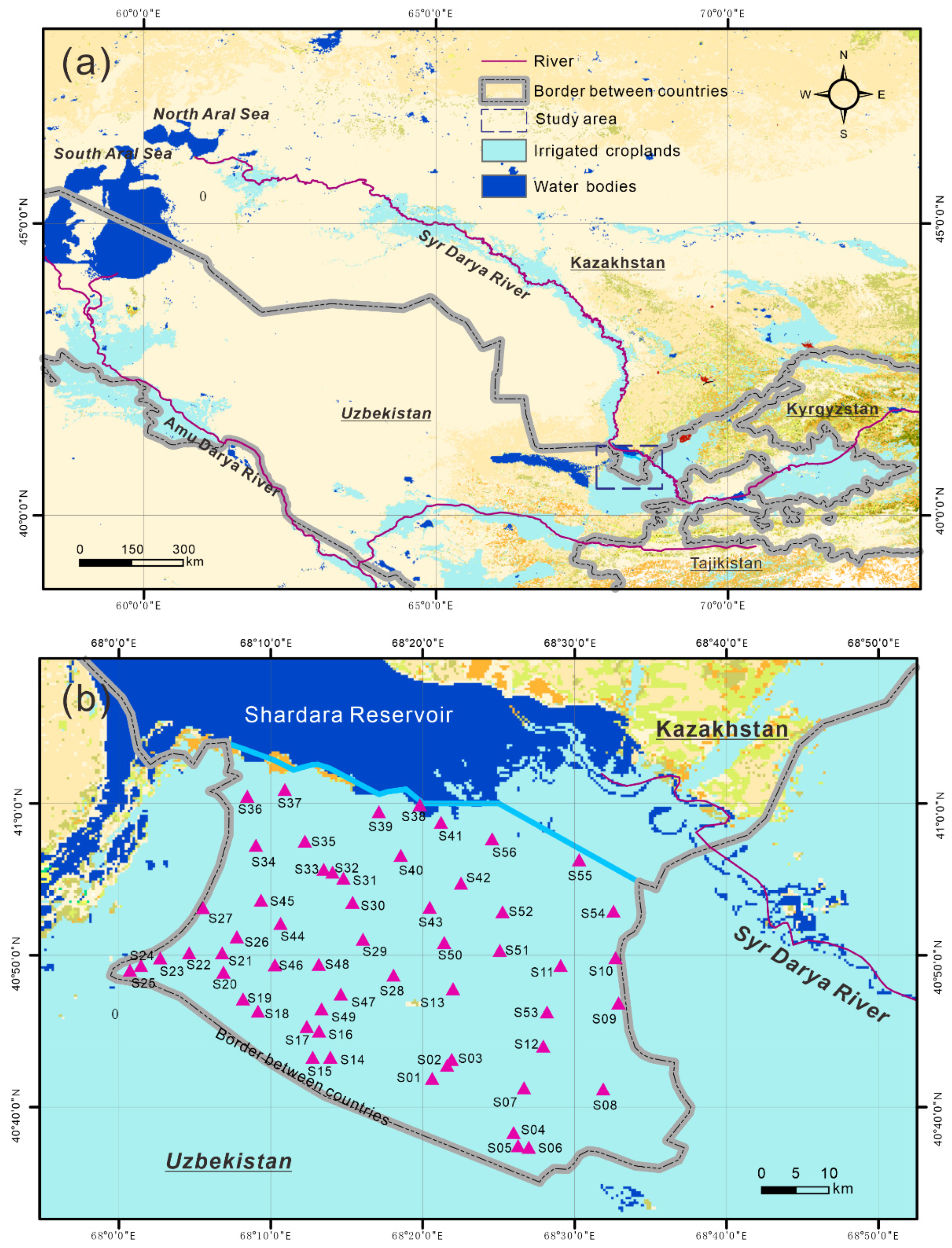
2.1. Sampling and Laboratory Analysis
2.2. Statistical Analysis
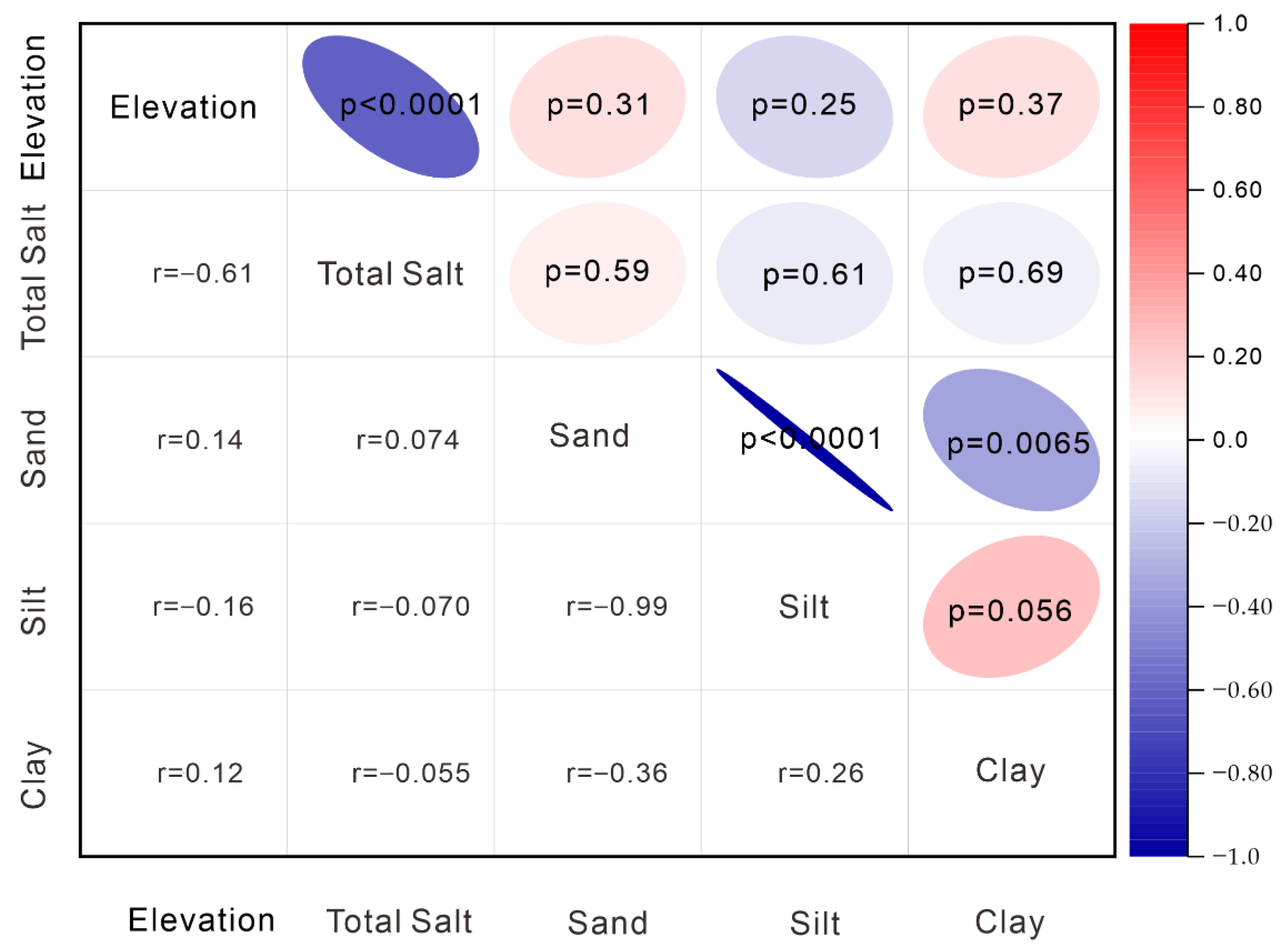
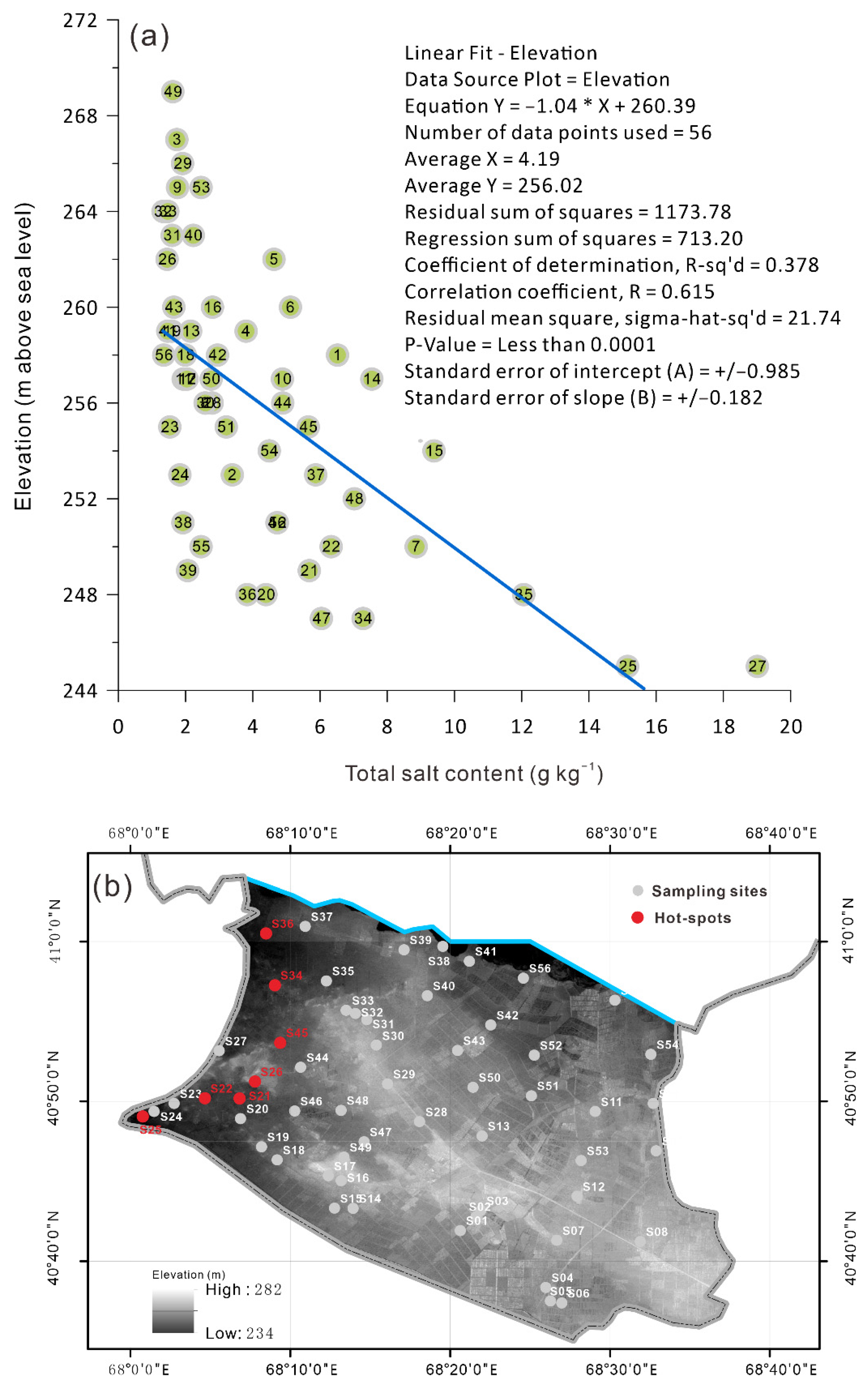
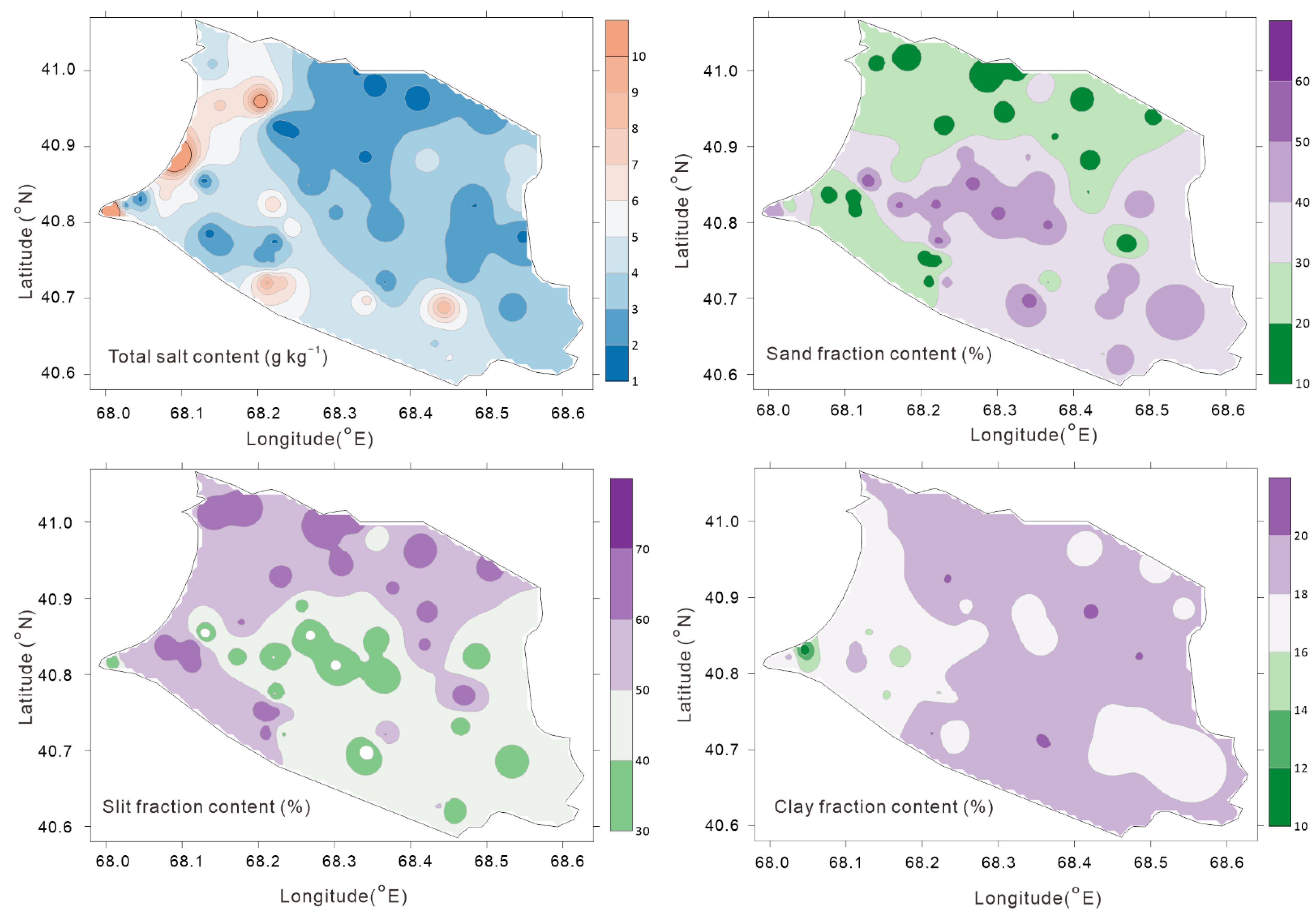
3. Results
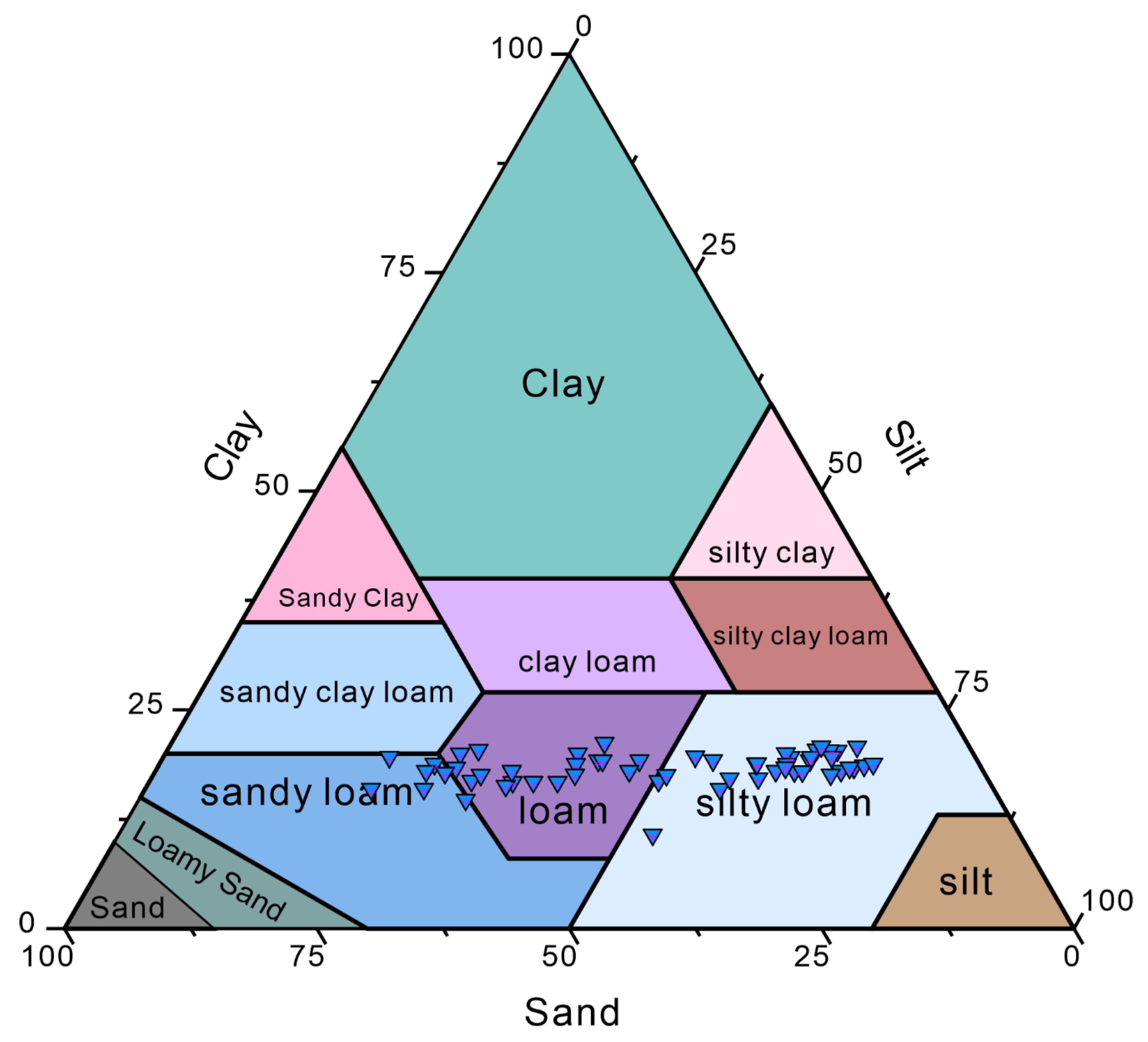
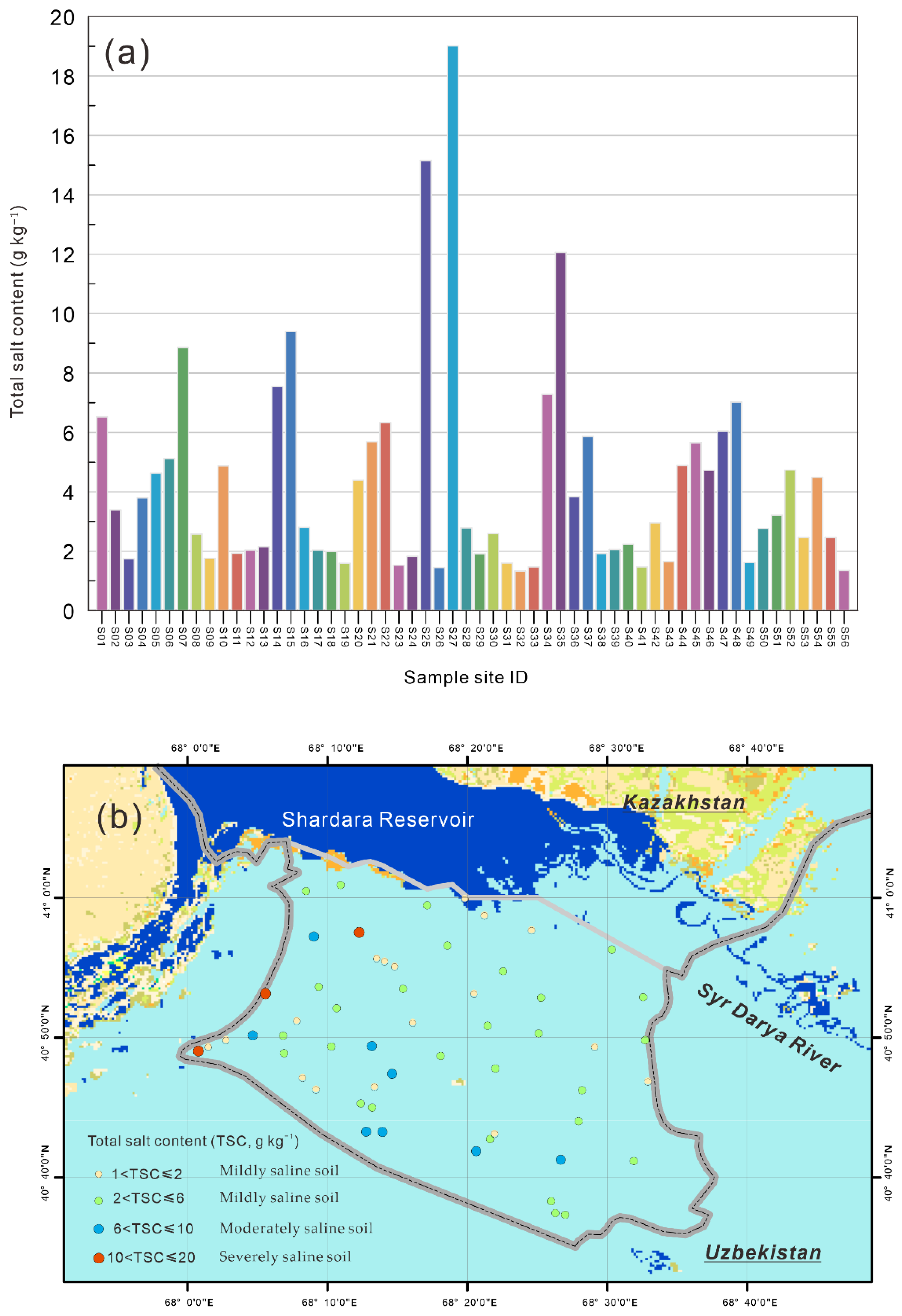
3.1. Basic Characteristics of Soil Texture and Soil Salinity
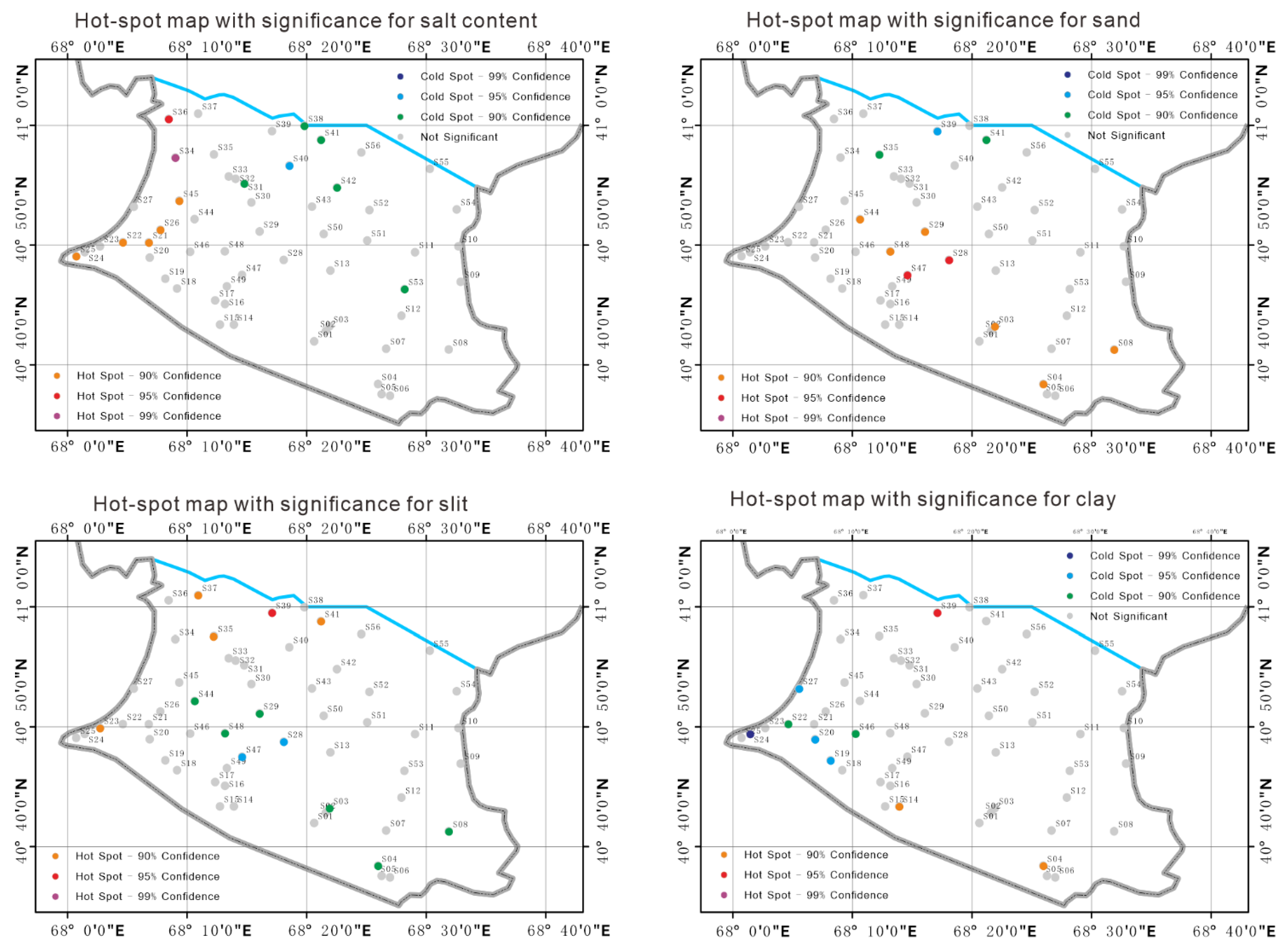
3.2. Spatial Autocorrelation and Hotspot Analysis
4. Discussion
5. Conclusions
Author Contributions
Funding
Institutional Review Board Statement
Data Availability Statement
Acknowledgments
Conflicts of Interest
References
- Amundson, R.; Berhe, A.A.; Hopmans, J.W.; Olson, C.; Sztein, A.E.; Sparks, D.L. Soil and human security in the 21st century. Science 2015, 348, 1261071. [Google Scholar] [CrossRef] [PubMed] [Green Version]
- Huang, P.M.; Wang, S.-L.; Tzou, Y.-M.; Huang, Y.; Weng, B.; Zhuang, S.; Wang, M.K. Physicochemical and biological interfacial interactions: Impacts on soil ecosystem and biodiversity. Environ. Earth Sci. 2013, 68, 2199–2209. [Google Scholar] [CrossRef]
- Arshad, M.; Coen, G. Characterization of soil quality: Physical and chemical criteria. Am. J. Altern. Agric. 1992, 7, 25–31. [Google Scholar] [CrossRef]
- Zhao, H.; Cui, J.; Zhou, R.; Zhang, T.; Zhao, X.; Drake, S. Soil properties, crop productivity and irrigation effects on five croplands of Inner Mongolia. Soil Tillage Res. 2007, 93, 346–355. [Google Scholar] [CrossRef]
- Pierce, F.; Lal, R. Monitoring the impact of soil erosion on crop productivity. In Soil Erosion Research Methods; Routledge: Boca Raton, FL, USA, 2017; pp. 235–263. [Google Scholar]
- Hevia, G.G.; Buschiazzo, D.E.; Hepper, E.N.; Urioste, A.; Antón, E. Organic matter in size fractions of soils of the semiarid Argentina. Effects of climate, soil texture and management. Geoderma 2003, 116, 265–277. [Google Scholar] [CrossRef]
- Pahlavan-Rad, M.R.; Akbarimoghaddam, A. Spatial variability of soil texture fractions and pH in a flood plain (case study from eastern Iran). Catena 2018, 160, 275–281. [Google Scholar] [CrossRef]
- Hu, H.; Tian, F.; Hu, H. Soil particle size distribution and its relationship with soil water and salt under mulched drip irrigation in Xinjiang of China. Sci. China-Technol. Sci. 2011, 54, 1568–1574. [Google Scholar] [CrossRef]
- Qadir, M.; Noble, A.D.; Schubert, S.; Thomas, R.J.; Arslan, A. Sodicity-induced land degradation and its sustainable management: Problems and prospects. Land Degrad. Dev. 2006, 17, 661–676. [Google Scholar] [CrossRef]
- Shahid, S.A.; Zaman, M.; Heng, L. Soil salinity: Historical perspectives and a world overview of the problem. In Guideline for Salinity Assessment, Mitigation and Adaptation Using Nuclear and Related Techniques; Springer Nature Switzerland AG: Cham, Switzerland, 2018; pp. 43–53. [Google Scholar]
- Metternicht, G.I.; Zinck, J. Remote sensing of soil salinity: Potentials and constraints. Remote Sens. Environ. 2003, 85, 1–20. [Google Scholar] [CrossRef]
- Daliakopoulos, I.; Tsanis, I.; Koutroulis, A.; Kourgialas, N.; Varouchakis, A.; Karatzas, G.; Ritsema, C. The threat of soil salinity: A European scale review. Sci. Total Environ. 2016, 573, 727–739. [Google Scholar] [CrossRef]
- Smedema, L.K.; Shiati, K. Irrigation and salinity: A perspective review of the salinity hazards of irrigation development in the arid zone. Irrig. Drain. Syst. 2002, 16, 161–174. [Google Scholar] [CrossRef]
- Selcer, P. 4. The Soil Map Of The World And The Politics Of Scale. In The Postwar Origins of the Global Environment; Columbia University Press: New York, NY, USA, 2018; pp. 133–172. [Google Scholar]
- Selcer, P. Fabricating unity: The FAO-UNESCO soil map of the world. Hist. Soc. Res. 2015, 40, 174–201. [Google Scholar]
- Rispoli, G.; Olšáková, D. Science and Diplomacy around the Earth: From the Man and Biosphere Programme to the International Geosphere-Biosphere Programme. Hist. Stud. Nat. Sci. 2020, 50, 456–481. [Google Scholar] [CrossRef]
- Kovda, V.A. The Earth’s living matter: Biosphere and soils. Environ. Conserv. 1993, 20, 199–204. [Google Scholar] [CrossRef]
- Jia, Q.; Li, Y.; Li, Y.; Huang, G. Analyzing variation of inflow from the Syr Darya to the Aral Sea: A Bayesian-neural-network-based factorial analysis method. J. Hydrol. 2020, 587, 124976. [Google Scholar] [CrossRef]
- Wang, H.; Luo, G.; Wang, W.; Konstantin, P.; Li, Y.; Zheng, H.; Hu, W. Inversion of soil moisture content in the farmland in middle and lower reaches of Syr Darya River Basin based on multi-source remotely sensed data. J. Nat. Resour. 2019, 34, 2717–2731. [Google Scholar]
- Ma, L.; Abuduwaili, J.; Smanov, Z.; Ge, Y.; Samarkhanov, K.; Saparov, G.; Issanova, G. Spatial and Vertical Variations and Heavy Metal Enrichments in Irrigated Soils of the Syr Darya River Watershed, Aral Sea Basin, Kazakhstan. Int. J. Environ. Res. Public Health 2019, 16, 4398. [Google Scholar] [CrossRef] [Green Version]
- Solodukhin, V.; Poznyak, V.; Kazachevskiy, I.; Knyazev, B.; Lukashenko, S.; Khazhekber, S. Some peculiarities of the contamination with radionuclides and toxic elements of the Syrdarya river basin, Kazakhstan. J. Radioanal. Nucl. Chem. 2004, 259, 245–250. [Google Scholar] [CrossRef]
- Ma, X.; Zhu, J.; Yan, W.; Zhao, C. Assessment of soil conservation services of four river basins in Central Asia under global warming scenarios. Geoderma 2020, 375, 114533. [Google Scholar] [CrossRef]
- Platonov, A.; Noble, A.; Kuziev, R. Soil Salinity Mapping Using Multi-Temporal Satellite Images in Agricultural Fields of Syrdarya Province of Uzbekistan. In Developments in Soil Salinity Assessment and Reclamation: Innovative Thinking and Use of Marginal Soil and Water Resources in Irrigated Agriculture; Shahid, S.A., Abdelfattah, M.A., Taha, F.K., Eds.; Springer: Dordrecht, The Netherlands, 2013; pp. 87–98. [Google Scholar]
- AbdelRahman, M.A.; Zakarya, Y.M.; Metwaly, M.M.; Koubouris, G. Deciphering Soil Spatial Variability through Geostatistics and Interpolation Techniques. Sustainability 2021, 13, 194. [Google Scholar] [CrossRef]
- Wang, Z.; Zhang, F.; Zhang, X.; Chan, N.W.; Kung, H.-t.; Zhou, X.; Wang, Y. Quantitative evaluation of spatial and temporal variation of soil salinization risk using GIS-based geostatistical method. Remote Sens. 2020, 12, 2405. [Google Scholar] [CrossRef]
- Wang, Z.; Chen, X.; Yu, D.; Zhang, L.; Wang, J.; Lv, J. Source apportionment and spatial distribution of potentially toxic elements in soils: A new exploration on receptor and geostatistical models. Sci. Total Environ. 2021, 759, 143428. [Google Scholar] [CrossRef] [PubMed]
- Jin, Z.; Zhang, L.; Lv, J.; Sun, X. The application of geostatistical analysis and receptor model for the spatial distribution and sources of potentially toxic elements in soils. Environ. Geochem. Health 2021, 43, 407–421. [Google Scholar] [CrossRef] [PubMed]
- Lin, Y.-P.; Chu, H.-J.; Wu, C.-F.; Chang, T.-K.; Chen, C.-Y. Hotspot Analysis of Spatial Environmental Pollutants Using Kernel Density Estimation and Geostatistical Techniques. Int. J. Environ. Res. Public Health 2011, 8, 75–88. [Google Scholar] [CrossRef]
- Hu, Y.; Wang, F.; Guin, C.; Zhu, H. A spatio-temporal kernel density estimation framework for predictive crime hotspot mapping and evaluation. Appl. Geogr. 2018, 99, 89–97. [Google Scholar] [CrossRef]
- Spencer, C.J.; Yakymchuk, C.; Ghaznavi, M. Visualising data distributions with kernel density estimation and reduced chi-squared statistic. Geosci. Front. 2017, 8, 1247–1252. [Google Scholar] [CrossRef]
- Wang, D.; Li, M. Robust stochastic configuration networks with kernel density estimation for uncertain data regression. Inf. Sci. 2017, 412, 210–222. [Google Scholar] [CrossRef]
- Goovaerts, P. Geostatistical modelling of uncertainty in soil science. Geoderma 2001, 103, 3–26. [Google Scholar] [CrossRef]
- Linnik, V.G.; Bauer, T.V.; Minkina, T.M.; Mandzhieva, S.S.; Mazarji, M. Spatial distribution of heavy metals in soils of the flood plain of the Seversky Donets River (Russia) based on geostatistical methods. Environ. Geochem. Health 2020. online. [Google Scholar] [CrossRef]
- Jurišić, M.; Radočaj, D.; Krčmar, S.; Plaščak, I.; Gašparović, M. Geostatistical analysis of soil C/N deficiency and its effect on agricultural land management of major crops in eastern Croatia. Agronomy 2020, 10, 1996. [Google Scholar] [CrossRef]
- Xia, F.; Hu, B.; Zhu, Y.; Ji, W.; Chen, S.; Xu, D.; Shi, Z. Improved Mapping of Potentially Toxic Elements in Soil via Integration of Multiple Data Sources and Various Geostatistical Methods. Remote Sens. 2020, 12, 3775. [Google Scholar] [CrossRef]
- Lee, S.; Na, S.; Rogers, O.G.; Youn, S. Quantifying surface morphology of manufactured activated carbon and the waste coffee grounds using the Getis-Ord-Gi* statistic and Ripley’s K function. Sci. Rep. 2021, 11, 7543. [Google Scholar] [CrossRef] [PubMed]
- Olea, R.A. A six-step practical approach to semivariogram modeling. Stoch. Environ. Res. Risk Assess. 2006, 20, 307–318. [Google Scholar] [CrossRef]
- Koike, K.; Kiriyama, T.; Lu, L.; Kubo, T.; Heriawan, M.N.; Yamada, R. Incorporation of geological constraints and semivariogram scaling law into geostatistical modeling of metal contents in hydrothermal deposits for improved accuracy. J. Geochem. Explor. 2022, 233, 106901. [Google Scholar] [CrossRef]
- Harris, I.; Osborn, T.J.; Jones, P.; Lister, D. Version 4 of the CRU TS monthly high-resolution gridded multivariate climate dataset. Sci. Data 2020, 7, 109. [Google Scholar] [CrossRef] [PubMed] [Green Version]
- Nachtergaele, F.; van Velthuizen, H.; Verelst, L.; Batjes, N.; Dijkshoorn, K.; van Engelen, V.; Fischer, G.; Jones, A.; Montanarela, L. The harmonized world soil database. In Proceedings of the 19th World Congress of Soil Science, Soil Solutions for a Changing World, Brisbane, Australia, 1–6 August 2010; pp. 34–37. [Google Scholar]
- Beuselinck, L.; Govers, G.; Poesen, J.; Degraer, G.; Froyen, L. Grain-size analysis by laser diffractometry: Comparison with the sieve-pipette method. Catena 1998, 32, 193–208. [Google Scholar] [CrossRef]
- Igaz, D.; Aydin, E.; Šinkovičová, M.; Šimanský, V.; Tall, A.; Horák, J. Laser diffraction as an innovative alternative to standard pipette method for determination of soil texture classes in Central Europe. Water 2020, 12, 1232. [Google Scholar] [CrossRef]
- Arriaga, F.J.; Lowery, B.; Mays, M.D. A fast method for determining soil particle size distribution using a laser instrument. Soil Sci. 2006, 171, 663–674. [Google Scholar] [CrossRef] [Green Version]
- Liu, J.; Hu, F.; Xu, C.; Wang, Z.; Ma, R.; Zhao, S.; Liu, G. Comparison of different methods for assessing effects of soil interparticle forces on aggregate stability. Geoderma 2021, 385, 114834. [Google Scholar] [CrossRef]
- Thomas, C.L.; Hernandez-Allica, J.; Dunham, S.J.; McGrath, S.P.; Haefele, S.M. A comparison of soil texture measurements using mid-infrared spectroscopy (MIRS) and laser diffraction analysis (LDA) in diverse soils. Sci. Rep. 2021, 11, 1–12. [Google Scholar]
- Peng, Y.; Keating, K.; Myers, D.B. NMR relaxation times for soil texture estimation in the laboratory: A comparison to the laser diffraction and sieve–pipette methods. Eur. J. Soil Sci. 2021, 72, 918–933. [Google Scholar] [CrossRef]
- Qi, F.; Zhang, R.; Liu, X.; Niu, Y.; Zhang, H.; Li, H.; Li, J.; Wang, B.; Zhang, G. Soil particle size distribution characteristics of different land-use types in the Funiu mountainous region. Soil Tillage Res. 2018, 184, 45–51. [Google Scholar] [CrossRef]
- Feng, Y.; Chen, X.; Gao, F.; Liu, Y. Impacts of changing scale on Getis-Ord Gi* hotspots of CPUE: A case study of the neon flying squid (Ommastrephes bartramii) in the northwest Pacific Ocean. Acta Oceanolog. Sin. 2018, 37, 67–76. [Google Scholar] [CrossRef]
- Kumar, S.; Parida, B.R. Hydroponic farming hotspot analysis using the Getis–Ord Gi* statistic and high-resolution satellite data of Majuli Island, India. Remote Sens. Lett. 2021, 12, 408–418. [Google Scholar] [CrossRef]
- Ren, H.; Shang, Y.; Zhang, S. Measuring the spatiotemporal variations of vegetation net primary productivity in Inner Mongolia using spatial autocorrelation. Ecol. Indic. 2020, 112, 106108. [Google Scholar] [CrossRef]
- Al-Kindi, K.M.; Alkharusi, A.; Alshukaili, D.; Al Nasiri, N.; Al-Awadhi, T.; Charabi, Y.; El Kenawy, A.M. Spatiotemporal assessment of COVID-19 spread over Oman using GIS techniques. Earth Syst. Environ. 2020, 4, 797–811. [Google Scholar] [CrossRef]
- Hu, X.; Ma, C.; Huang, P.; Guo, X. Ecological vulnerability assessment based on AHP-PSR method and analysis of its single parameter sensitivity and spatial autocorrelation for ecological protection–A case of Weifang City, China. Ecol. Indic. 2021, 125, 107464. [Google Scholar] [CrossRef]
- Anselin, L.; Syabri, I.; Kho, Y. GeoDa: An introduction to spatial data analysis. In Handbook of Applied Spatial Analysis; Springer: Berlin/Heidelberg, Germany, 2010; pp. 73–89. [Google Scholar]
- Lin, M.; Lin, T.; Jones, L.; Liu, X.; Xing, L.; Sui, J.; Zhang, J.; Ye, H.; Liu, Y.; Zhang, G. Quantitatively assessing ecological stress of urbanization on natural ecosystems by using a landscape-adjacency index. Remote Sens. 2021, 13, 1352. [Google Scholar] [CrossRef]
- Pezzulo, C.; Nilsen, K.; Carioli, A.; Tejedor-Garavito, N.; Hanspal, S.E.; Hilber, T.; James, W.H.; Ruktanonchai, C.W.; Alegana, V.; Sorichetta, A. Geographical distribution of fertility rates in 70 low-income, lower-middle-income, and upper-middle-income countries, 2010–2016: A subnational analysis of cross-sectional surveys. Lancet Glob. Health 2021, 9, e802–e812. [Google Scholar] [CrossRef]
- Makowski, D.; Ben-Shachar, M.S.; Patil, I.; Lüdecke, D. Methods and algorithms for correlation analysis in R. J. Open Source Soft. 2020, 5, 2306. [Google Scholar] [CrossRef]
- García-Gaines, R.A.; Frankenstein, S. USCS and the USDA Soil Classification System: Development of a Mapping Scheme; U.S. Army Engineer Research and Development Center: Vicksburg, MS, USA, 2015. [Google Scholar]
- Groenendyk, D.G.; Ferré, T.P.A.; Thorp, K.R.; Rice, A.K. Hydrologic-Process-Based Soil Texture Classifications for Improved Visualization of Landscape Function. PLoS ONE 2015, 10, e0131299. [Google Scholar] [CrossRef] [PubMed] [Green Version]
- Wang, Z.; Zhang, X.; Zhang, F.; Chan, N.w.; Kung, H.-t.; Liu, S.; Deng, L. Estimation of soil salt content using machine learning techniques based on remote-sensing fractional derivatives, a case study in the Ebinur Lake Wetland National Nature Reserve, Northwest China. Ecol. Indic. 2020, 119, 106869. [Google Scholar] [CrossRef]
- Zhang, W.-T.; Wu, H.-Q.; Gu, H.-B.; Feng, G.-L.; Wang, Z.; Sheng, J.-D. Variability of Soil Salinity at Multiple Spatio-Temporal Scales and the Related Driving Factors in the Oasis Areas of Xinjiang, China. Pedosphere 2014, 24, 753–762. [Google Scholar] [CrossRef]
- Wang, F.; Chen, X.; Luo, G.; Han, Q. Mapping of regional soil salinities in Xinjiang and strategies for amelioration and management. Chin. Geogr. Sci. 2015, 25, 321–336. [Google Scholar] [CrossRef]
- Abuduwaili, J.; Tang, Y.; Abulimiti, M.; Liu, D.; Ma, L. Spatial distribution of soil moisture, salinity and organic matter in Manas River watershed, Xinjiang, China. J. Arid Land 2012, 4, 441–449. [Google Scholar] [CrossRef]
- Jiang, H.; Shu, H. Optical remote-sensing data based research on detecting soil salinity at different depth in an arid-area oasis, Xinjiang, China. Earth Sci. Inf. 2019, 12, 43–56. [Google Scholar] [CrossRef]
- Wang, Y.; Xiao, D.; Li, Y.; Li, X. Soil salinity evolution and its relationship with dynamics of groundwater in the oasis of inland river basins: Case study from the Fubei region of Xinjiang Province, China. Environ. Monit. Assess. 2008, 140, 291–302. [Google Scholar] [CrossRef]
- Fu, C.; Gan, S.; Yuan, X.; Xiong, H.; Tian, A. Determination of soil salt content using a probability neural network model based on particle swarm optimization in areas affected and non-affected by human activities. Remote Sens. 2018, 10, 1387. [Google Scholar] [CrossRef] [Green Version]
- Huang, J.; Hartemink, A.E. Soil and environmental issues in sandy soils. Earth-Sci. Rev. 2020, 208, 103295. [Google Scholar] [CrossRef]
- Tobler, W.R. A computer movie simulating urban growth in the Detroit region. Econ. Geogr. 1970, 46, 234–240. [Google Scholar] [CrossRef]
- Shukla, K.; Kumar, P.; Mann, G.S.; Khare, M. Mapping spatial distribution of particulate matter using Kriging and Inverse Distance Weighting at supersites of megacity Delhi. Sust. Cities Soc. 2020, 54, 101997. [Google Scholar] [CrossRef]
- Chen, F.-W.; Liu, C.-W. Estimation of the spatial rainfall distribution using inverse distance weighting (IDW) in the middle of Taiwan. Paddy Water Environ. 2012, 10, 209–222. [Google Scholar] [CrossRef]
- Shen, Q.; Wang, Y.; Wang, X.; Liu, X.; Zhang, X.; Zhang, S. Comparing interpolation methods to predict soil total phosphorus in the Mollisol area of Northeast China. Catena 2019, 174, 59–72. [Google Scholar] [CrossRef]
- Schultz, B.; De Wrachien, D. Irrigation and drainage systems research and development in the 21st century. Irrig. Drain. 2002, 51, 311–327. [Google Scholar] [CrossRef]
- Machado, R.M.A.; Serralheiro, R.P. Soil Salinity: Effect on Vegetable Crop Growth. Management Practices to Prevent and Mitigate Soil Salinization. Horticulturae 2017, 3, 30. [Google Scholar] [CrossRef]
- Rhoades, J.D.; Lesch, S.M.; LeMert, R.D.; Alves, W.J. Assessing irrigation/drainage/salinity management using spatially referenced salinity measurements. Agric. Water Manag. 1997, 35, 147–165. [Google Scholar] [CrossRef]
- Cobo, J.G.; Dercon, G.; Yekeye, T.; Chapungu, L.; Kadzere, C.; Murwira, A.; Delve, R.; Cadisch, G. Integration of mid-infrared spectroscopy and geostatistics in the assessment of soil spatial variability at landscape level. Geoderma 2010, 158, 398–411. [Google Scholar] [CrossRef]
- Wang, Y.; Zhang, X.; Huang, C. Spatial variability of soil total nitrogen and soil total phosphorus under different land uses in a small watershed on the Loess Plateau, China. Geoderma 2009, 150, 141–149. [Google Scholar] [CrossRef]
- Dobermann, A. Factors causing field variation of direct-seeded flooded rice. Geoderma 1994, 62, 125–150. [Google Scholar] [CrossRef]
- Garten, C.T.; Kang, S.; Brice, D.J.; Schadt, C.W.; Zhou, J. Variability in soil properties at different spatial scales (1m–1km) in a deciduous forest ecosystem. Soil Biol. Biochem. 2007, 39, 2621–2627. [Google Scholar] [CrossRef]
- Wang, F.; Shi, Z.; Biswas, A.; Yang, S.; Ding, J. Multi-algorithm comparison for predicting soil salinity. Geoderma 2020, 365, 114211. [Google Scholar] [CrossRef]
- Hassani, A.; Azapagic, A.; Shokri, N. Predicting long-term dynamics of soil salinity and sodicity on a global scale. Proc. Natl. Acad. Sci. USA 2020, 117, 33017–33027. [Google Scholar] [CrossRef] [PubMed]

| Parameters | Mean | Standard Deviation | SE of Mean | Minimum | Median | Maximum |
|---|---|---|---|---|---|---|
| Coarse sand | 0.40 | 0.42 | 0.06 | 0.04 | 0.28 | 1.95 |
| Fine sand | 31.25 | 15.69 | 2.10 | 10.13 | 29.17 | 61.66 |
| Coarse silt | 32.60 | 14.16 | 1.89 | 0.81 | 34.76 | 55.51 |
| Medium silt | 6.72 | 3.57 | 0.48 | 0.00 | 6.04 | 15.74 |
| Fine silt | 10.98 | 2.23 | 0.30 | 5.65 | 11.29 | 17.34 |
| Clay | 18.06 | 1.75 | 0.23 | 10.47 | 18.14 | 20.96 |
| Total salinity | 0.42 | 0.35 | 0.05 | 0.13 | 0.28 | 1.90 |
| Variable | Moran’s I | p | z |
|---|---|---|---|
| Total salt content | 0.0434 | 0.199 | 0.78 |
| Sand | 0.196 | 0.01 | 2.7099 |
| Silt | 0.219 | 0.003 | 3.0181 |
| Clay | 0.145 | 0.022 | 2.1311 |
Publisher’s Note: MDPI stays neutral with regard to jurisdictional claims in published maps and institutional affiliations. |
© 2022 by the authors. Licensee MDPI, Basel, Switzerland. This article is an open access article distributed under the terms and conditions of the Creative Commons Attribution (CC BY) license (https://creativecommons.org/licenses/by/4.0/).
Share and Cite
Liu, W.; Ma, L.; Smanov, Z.; Samarkhanov, K.; Abuduwaili, J. Clarifying Soil Texture and Salinity Using Local Spatial Statistics (Getis-Ord Gi* and Moran’s I) in Kazakh–Uzbekistan Border Area, Central Asia. Agronomy 2022, 12, 332. https://doi.org/10.3390/agronomy12020332
Liu W, Ma L, Smanov Z, Samarkhanov K, Abuduwaili J. Clarifying Soil Texture and Salinity Using Local Spatial Statistics (Getis-Ord Gi* and Moran’s I) in Kazakh–Uzbekistan Border Area, Central Asia. Agronomy. 2022; 12(2):332. https://doi.org/10.3390/agronomy12020332
Chicago/Turabian StyleLiu, Wen, Long Ma, Zhassulan Smanov, Kanat Samarkhanov, and Jilili Abuduwaili. 2022. "Clarifying Soil Texture and Salinity Using Local Spatial Statistics (Getis-Ord Gi* and Moran’s I) in Kazakh–Uzbekistan Border Area, Central Asia" Agronomy 12, no. 2: 332. https://doi.org/10.3390/agronomy12020332
APA StyleLiu, W., Ma, L., Smanov, Z., Samarkhanov, K., & Abuduwaili, J. (2022). Clarifying Soil Texture and Salinity Using Local Spatial Statistics (Getis-Ord Gi* and Moran’s I) in Kazakh–Uzbekistan Border Area, Central Asia. Agronomy, 12(2), 332. https://doi.org/10.3390/agronomy12020332