Review

The Mangrove Swamp Rice Production System of Guinea Bissau: Identification of the Main Constraints Associated with Soil Salinity and Rainfall Variability

by
Gabriel Garbanzo
1,2,3,*,
Maria do Rosário Cameira
1 and
Paula Paredes
1,*
1
LEAF-Linking Landscape, Environment, Agriculture and Food Research Center, Associate Laboratory TERRA, Instituto Superior de Agronomia, School of Agriculture, University of Lisbon, Tapada da Ajuda, 1349-017 Lisboa, Portugal
2
Center for Crop System Analysis, Wageningen University and Research, P.O. Box 47, 6700 AA Wageningen, The Netherlands
3
Agronomic Research Center, School of Agriculture, University of Costa Rica, San José 11501-2060, Costa Rica
*
Authors to whom correspondence should be addressed.
Agronomy 2024, 14(3), 468; https://doi.org/10.3390/agronomy14030468
Submission received: 29 December 2023 / Revised: 22 February 2024 / Accepted: 22 February 2024 / Published: 27 February 2024

Abstract

:
Mangrove swamp rice production (MSRP) refers to rice cultivation in former mangrove soils that have been anthropogenically modified for food production. The method utilizes the largest possible storage of fresh water to desalinate the soils and make them productive. However, temporal variability in rainfall patterns causes loss of efficiency in production, impacting crop growth and reducing productivity. To improve MSRP, it is necessary to identify the primary constraints associated with salinity, enhancing and maximizing freshwater storage efficiency and water productivity. This study provides a general description of the MSRP system in both the northern and southern regions of Guinea-Bissau, aiming at the identification of the main water management limitations. The description involves the use of typologies and the identification of zones with specific characteristics within the paddies. Furthermore, this review includes an analysis of the physicochemical characteristics of soils in relation to salinity issues, descriptions of agronomic management, rice varieties, and the significance of managing dikes and bunds to improve mangrove swamp rice water management. This study shows how the MSRPS is characterized by dynamism and complexity, involving a wide range of constraints associated with salinity features, cultural influences, and microclimatic conditions that are subject to temporal variations.

1. Introduction

Rice (Oryza sativa L. and O. glaberrima) is one of the most important staple foods on the Asian, African, and American continents. Global rice production over the past decade is estimated at approximately 540 million tons [1,2].
The rice crop grows primarily in the humid and seasonally dry tropics of the world, in most cases with irrigation or freshwater harvesting systems [3]. Worldwide, flood irrigation is the most widely used irrigation method for rice cultivation [4]. Rice paddy fields are usually permanently flooded, but with the aim of reducing water use, several flooding variants have been introduced such as dry seeding [5,6], anticipated cut-off, and intermittent water application [7]. Due to the increase of water shortages and scarcity, aerobic rice is being implemented using sprinklers or surface irrigation [8,9,10,11].
Most rice cultivars show remarkable adaptability to thrive in flooded agricultural systems [12], especially in regions characterized by abundant sunlight and access to freshwater resources [3]. Recent plant breeding has led to the development of modern cultivars adapted to aerobic conditions [13]. Rice productivity primarily depends on soil fertility, climatic factors, efficient water management, agronomic practices, weed control, and the adaptability of rice varieties [2,3,14]. It has been reported that rice productivity can reach values of 10 Mg ha−1 under optimal climatic and agronomic conditions and with the support of agrochemical inputs [12,15], but climate change calls for the adoption of agroecological pathways especially among smallholders living in marginal regions.
In the north-western regions of Africa, upland (slash-and-burn), inland lowland swamp, and mangrove swamp rice production can be found, all of which are rainfed. It is estimated that African rice production systems began 3000 to 2000 years ago [16,17,18,19]. Reports from overseas travelers during early colonization (between the years 1400–1600) indicated that the populations of countries such as Senegal, Gambia, Guinea-Bissau, Guinea Conakry, and Sierra Leone practiced rice cultivation [20,21,22]. This implies that the indigenous populations developed technological knowledge for rice production in different agroecological conditions, domesticated wild ancestors (Oryza glaberrima), and adapted exogenously introduced rice varieties (O. sativa) for these different conditions over many centuries [16]. In a context of high agro-ecological and cultural diversity, limited labor availability and access to agrochemicals, and a strong tradition of self-sufficiency, farmers’ rice varieties in West Africa are the result of a long breeding process shaped by both ecological and social factors [23,24]. The yields of farmers’ varieties therefore vary greatly depending on location, year, and production system, but as would be expected in the marginal regions where rice is grown without external inputs and/or irrigation, they often outperform the so-called high-yielding or “modern” varieties because they are well adapted to those harsh conditions [21,25]. In addition, it was reported that local farmers selected rice varieties based on several characteristics in addition to productivity, including fragrance, taste, digestion time, swelling during cooking, and ease of harvesting and threshing [26,27].
Guinea-Bissau (GB) is a small West African country (Figure 1) with a population of approximately two million people and an area of 37,500 square kilometers [28,29,30], having borders with Senegal to the north and Guinea Conakry to the south. The country has extensive mangrove forests that extend across the entire national territory from south to north [28], and a total of 88 islands, 20 of which are inhabited [31,32]. In the mangrove regions, there are large areas of deforested land that are used for rice production. There are also upland areas where rainfed rice, vegetables, and fruit trees (namely cashews) are grown [28,29,33].
Rice production is crucial to GB as it forms the basis of the population’s diet. There are three rice production systems in the country: mangrove swamp rice, upland (slash-and-burn) rice, and lowland swamp rice (rainfed and irrigated) [34]. The annual per capita rice consumption is estimated to be around 91–136.9 kg [35,36,37]. Nevertheless, daily rice consumption can vary significantly, ranging from 400 to 700 g depending on the location (rural or urban), the time of the year (dry vs. rainy season; after harvest vs. hungry period), and changing eating habits (one to three meals per day; inclusion or not in a diet of other cereals and root crops) of different ethnic groups (e.g., Balanta, Manjaco, Felupe, Baiote, Pepel, versus Fula and Mandinga) and households.
The mangrove swamp rice production system (MSRPS) is governed by soil salt concentration, and in some cases soil acidity, as well as the need for freshwater availability for plants. The MSRPS belongs to a rainfed wetland rice ecosystem, specifically within the category of sub-ecosystems that are prone to drought and flooding; thus, it is highly vulnerable to rainfall patterns, needing water harvesting in the plots to ensure rice production [37,38]. Rice sowing coincides with the start of the rainy season, when plots typically have low salt concentrations that favor the growth of salt-tolerant rice varieties [17,26]. The decision of when to sow is related to the timing when salinity in the plots is low. Decision making is based on traditional knowledge without the support of agronomic tools and has become more difficult due to increased rainfall variability (distribution and quantity) [39]. The timing of sowing has become unreliable, especially in the northern regions where rainfall is already scarce. To date, no studies on the dynamics of salt and water movement in the soil have been carried out for the MSRPS. The lack of sufficient knowledge about rainfall timings and salt dynamics often leads to inadequate crop development due to problems such as water shortages, toxicity, and acidity, which in some cases leads to complete crop loss [40]. Furthermore, MSRP is strongly influenced by spring tides, which often lead to saltwater intrusion [41] and a partial or total loss of rice production.
The MSRPS is dynamic and constantly changing due to its vulnerability to rainfall variability, which modifies freshwater storage and forces annual/seasonal adaptation of agronomic practices [42,43] through active improvisation/innovation by farmers [44]. Consequently, appropriate water management is essential to support farmers in reducing the high salinity of the soils in the plots on an annual basis.
Nowadays, temporal and spatial variability of rainfall in the country have become increasingly uncertain due to climate change [24,45,46]. It is well documented that certain regions of the world are more vulnerable to climate change, and GB is one such vulnerable country [15,41,44,47]. This susceptibility arises from its location in a transition zone between the African tropics and the Sahara Desert and its low-lying topography. The country’s agricultural production is highly dependent on rainfall, accounting for approximately 90% of its output [48,49]. Long-term average annual rainfall ranges from 1200 to 5000 mm depending on the region; further information is provided in Section 5. The temporal variability of rainfall has a potential influence on the food security of the population producing rice for subsistence purposes. Currently, rainfall is concentrated within a shorter period, limiting the production window for MSRP [41]. Additionally, heavy rainfall over a short period can lead to the destruction of MSRP infrastructure (dams and bunds) resulting in loss of production and further productivity of the rice fields. This issue is further dealt with in Section 5. Another constraint to agricultural production in GB is the lack of necessary infrastructure, such as deep wells and dams, to support irrigation [3,29,50].
The global aim of the present review article is to provide a conceptual framework for understanding the hydric–saline balance constraints of the MSRPS in GB. A systematic review could not be carried out, due to the small number of available articles on the subject and the need to include old (since the 1950s) and grey literature (e.g., books, governmental and project reports) that was not digitally accessible through the search engines (Agris, Scopus, ScienceDirect, Springer, Google Scholar) used in this review. The meteorological information and rice yield datasets were accessed from the agricultural and meteorological ministries of the country but have variable accuracy. The documents used were in various languages (English, French, Portuguese, and Spanish) along with the characterization of sites in the Kriol dialect. Additionally to the literature review, this article also comprises some empirical research, which includes transects conducted with farmers to provide on-site descriptions of the paddies’ diverse agroecologies, on-farm trials, soil sampling and analysis, biophysical characterization, and interviews with farmers about endogenous knowledge and technological innovation. In sum, the comprehensive research covers various essential aspects: (a) a biophysical description of the MSRPS; (b) agronomic management of the MSRPS; (c) key constraints, such as salinity and rainfall variability, and their impacts on water availability and rice yield; and (d) future research needs.

2. Rice Production in Guinea-Bissau

2.1. Rice Production Systems in GB

Rice in GB is produced in several ecologies with diverse techniques of cultivation. The less productive rice system is located in the uplands in former forests or savanna woodlands after slash-and-burn, and less frequently under palm oil groves (Figure 2). The degree of crop association is quite variable, as are the lengths of the crop–fallow periods [51,52]. Upland rice is known in GB as “N’pam-pam” or “arroz de lugar” (in the Kriol language) and is a rainfed production system. The sowing of N’pam-pam is usually carried out after the first rains of the year, as the production period is limited by rainfall and soil water availability [53]. Previously, within the total land area used for rice cultivation (14.7% of the country’s agricultural area), upland rice accounted for only 37% [29,54], while MSRP and lowland freshwater production (“Lalas” in Kriol) accounted for the remaining 63% [29]. However, the expansion of cash crop cultivation areas, particularly cashew, in recent years has led to a drastic reduction in the area occupied by the upland rice system [51].
The other rice production systems, in contrast, are carried out in the lowlands and include two different traditional systems of rice swamp cultivation, called in Kriol “bolanha doce” (inland freshwater swamp fields) and “bolanha salgada” (mangrove swamp fields). The local term “bolanha” refers to the fact that rice is cultivated with a permanent depth of water (permanent flooded paddies) until or almost until the end of the rice cycle. The freshwater swamps where rice is cultivated are located in inland valleys where there is a shallow water table or an impermeable soil layer that allows water storage and thus assures freshwater harvest [55]. This system is characteristic of north-eastern GB and is essentially performed by women belonging to the Fula and Mandinga ethnic groups, who plow with a hoe after burning the grasslands and do not usually build dikes [26]. In the other regions of the country (Cacheu, Oio, Quínara, and Tombali), men from other ethnic groups (such as the Balanta, the Manjaco, the Felupe, the Nalu, and the Beafada) can also produce freshwater swamp rice in wet savannah grasslands (”lalas” in Kriol), but using a long plow (“radi” in Kriol) with which they build dikes, ridges, and furrows [56], improving freshwater management. Freshwater rice production systems do not present salinity constraints and fields are usually far from mangrove forests. This rice production system accounts for approximately 10% of the 63% of the rice cultivation area that includes lowlands and saltwater plots [29]. In some areas of the Bafatá region of eastern GB, supplementary irrigation is used, with water being pumped from the river or using gravity-based drainage systems.

2.2. MSRP and Typologies of Fields

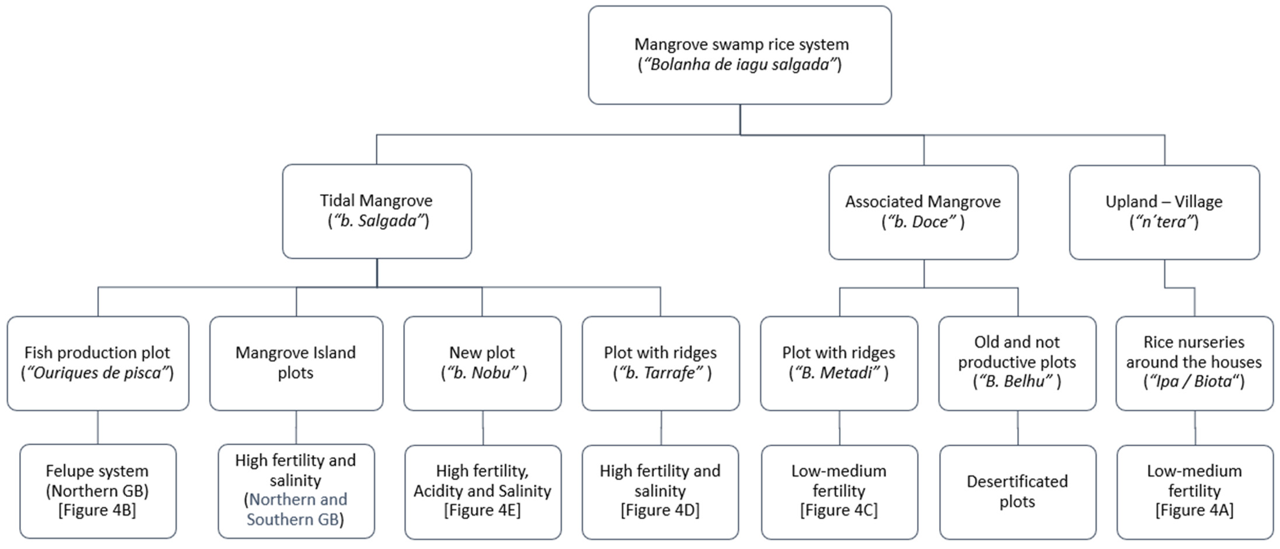
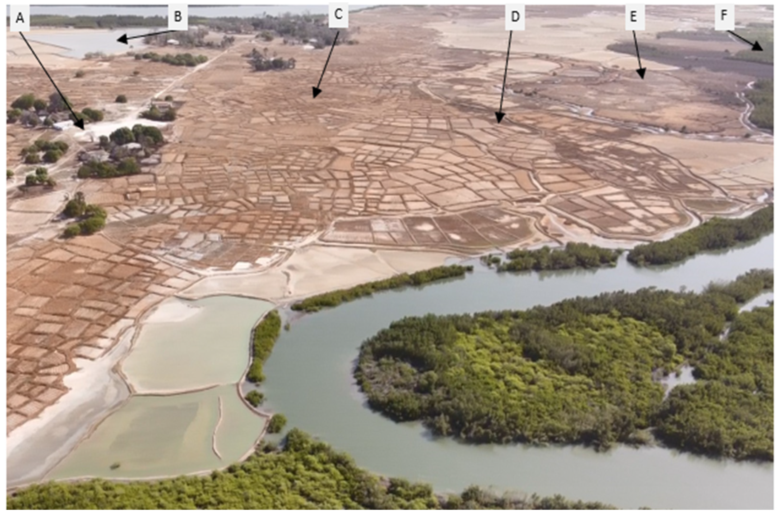
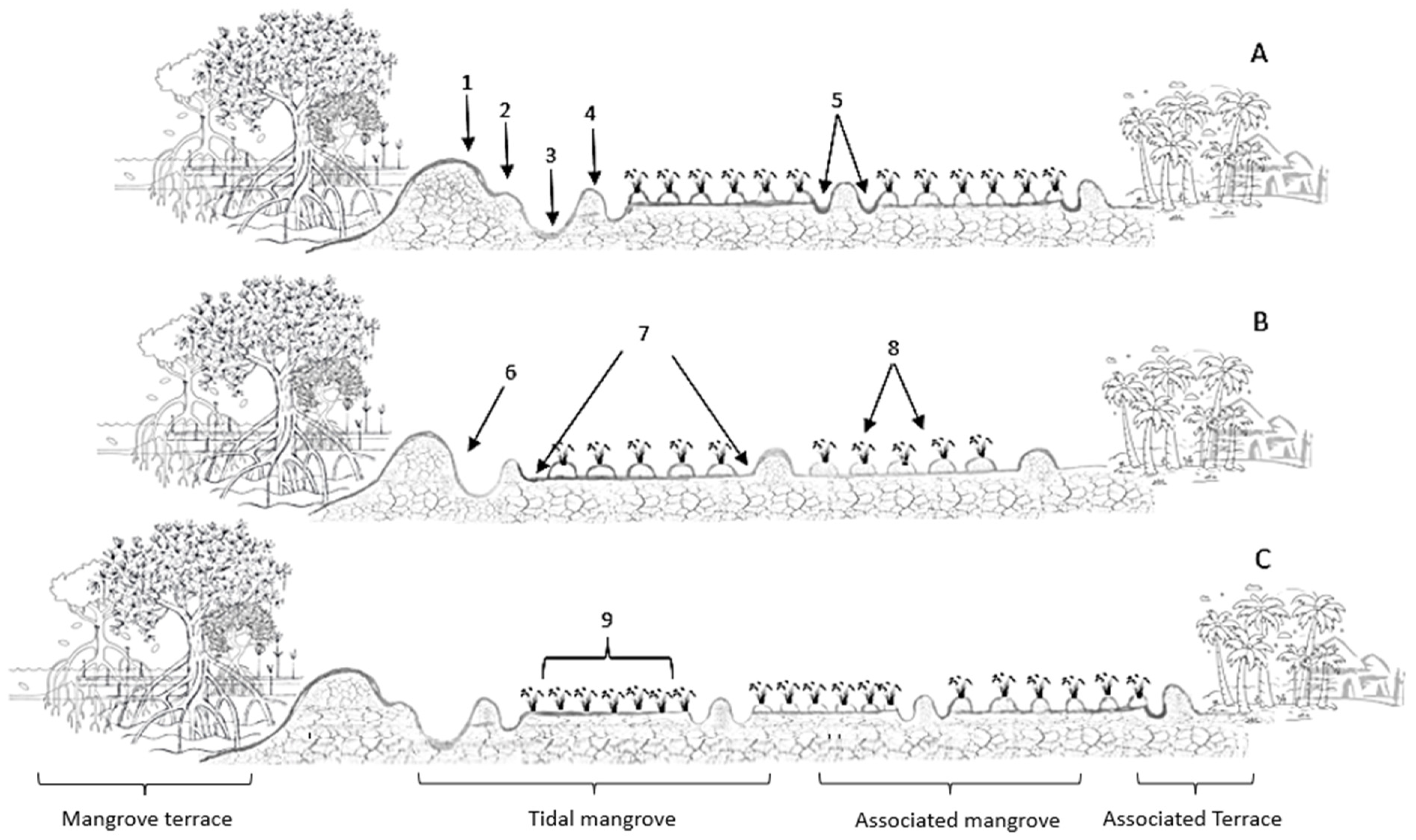
In the coastal areas near the mangrove forests, we can find the “bolanha salgada” rice paddies (MSR fields) (Figure 3 and Figure 4). This system is characterized by the former presence of mangrove forests, which over the years have been invaded by the tides that now cover part or the whole area of the rice fields. Farmers slash the mangroves, build a main dike to prevent saltwater intrusion and create plots of land for freshwater storage by dividing the area with bunds, which have been described in the previous literature as secondary dikes [57]. Coastal ethnic groups use these locations due to their high rice productivity compared with the uplands and inland swamp valleys. At the top of the weak slope that links the villages to the mangroves, there may exist a grassland area (“lala” in Kriol) where rainwater accumulates naturally due to the existence of a depression. As previously mentioned, farmers can use their MSRPS techniques to create “bolanha doce” (freshwater swamp rice fields) associated with the mangrove rice swamp fields, which have higher fertility and fewer weeds, but also salinity issues.
The rice fields which result from the destruction of the mangroves and that are periodically invaded by the tides are called in the literature tidal mangrove fields (bolanha de tarrafe in Kriol), while the upper fields where only the brackish groundwater induces soil salinity during the dry season are called associated mangroves (bolanha de metadi in Kriol, meaning ‘middle swamp fields’) (Figure 3). This part of the rice fields generally has weed species with low salinity tolerance and a wide diversity of grasses from the Poaceae family during the rainy season [58].
At the upper end of the associated mangrove area are the old swamp fields (“bolanha belhu”); these can be abandoned due to low fertility or cultivated with short-cycle upland rice varieties for the hungry season when there is land scarcity (namely, in Oio among the Balanta ethnic group). Farmers frequently abandon these plots because their productivity is very low and they do not provide sufficient returns on labor investments. The creation of new plots is triggered by decreasing fertility and, in the long-term, the occurrence of a desertification process (i.e., degraded land resources) [59]. Evidence of desertification problems has long been observed in the Casamance region of Senegal [57], which borders GB’s Cacheu region (Figure 1), where areas of low fertility and high salinity predominate. This highlights an inherent sustainability problem as producers fail to replenish nutrients depleted by crop growth through the incorporation of weeds and rice stubs during plowing. As farmers strive to sustainably meet their families’ rice production self-sufficiency needs, they are compelled to create new plots where they can achieve higher rice yields. Then, within each category, farmers from the northern, central, and southern regions divide the plots based on specific characteristics that increase their fertility and rice yields.
A possible cause of desertification in the abandoned mangrove swamp rice fields (“bolanha behlu”) is sodicity (Na+ accumulation) and loss of soil organic carbon concentration [59]. Some authors have suggested that the osmotic effect observed in the plants is due to a combination of salinity, iron toxicity, and soil acidification in the hydromorphic soils of GB [29,31,34,40,60,61]. Nevertheless, this is not sufficiently proven, as the literature does not provide data demonstrating concentrations of sulfur (S) and iron (Fe) in the first horizon of the plots’ soil. Some studies conducted specifically in mangrove soils indicate the presence of acidity caused by sulfuric acids, but this information refers specifically to soils previously covered by mangroves [40,60,62,63,64]. On this basis, it is possible that soils with significant concentrations of toxicity (such as Na and Fe) and acidity (SO3) occur predominantly in new mangrove fields (bolanha novo in Kriol) and to a lesser extent in older fields of the tidal mangrove area (bolanha de tarrafe in Kriol). This is due to their proximity to soils still covered with mangroves and their status as newly created sites for MSRP.
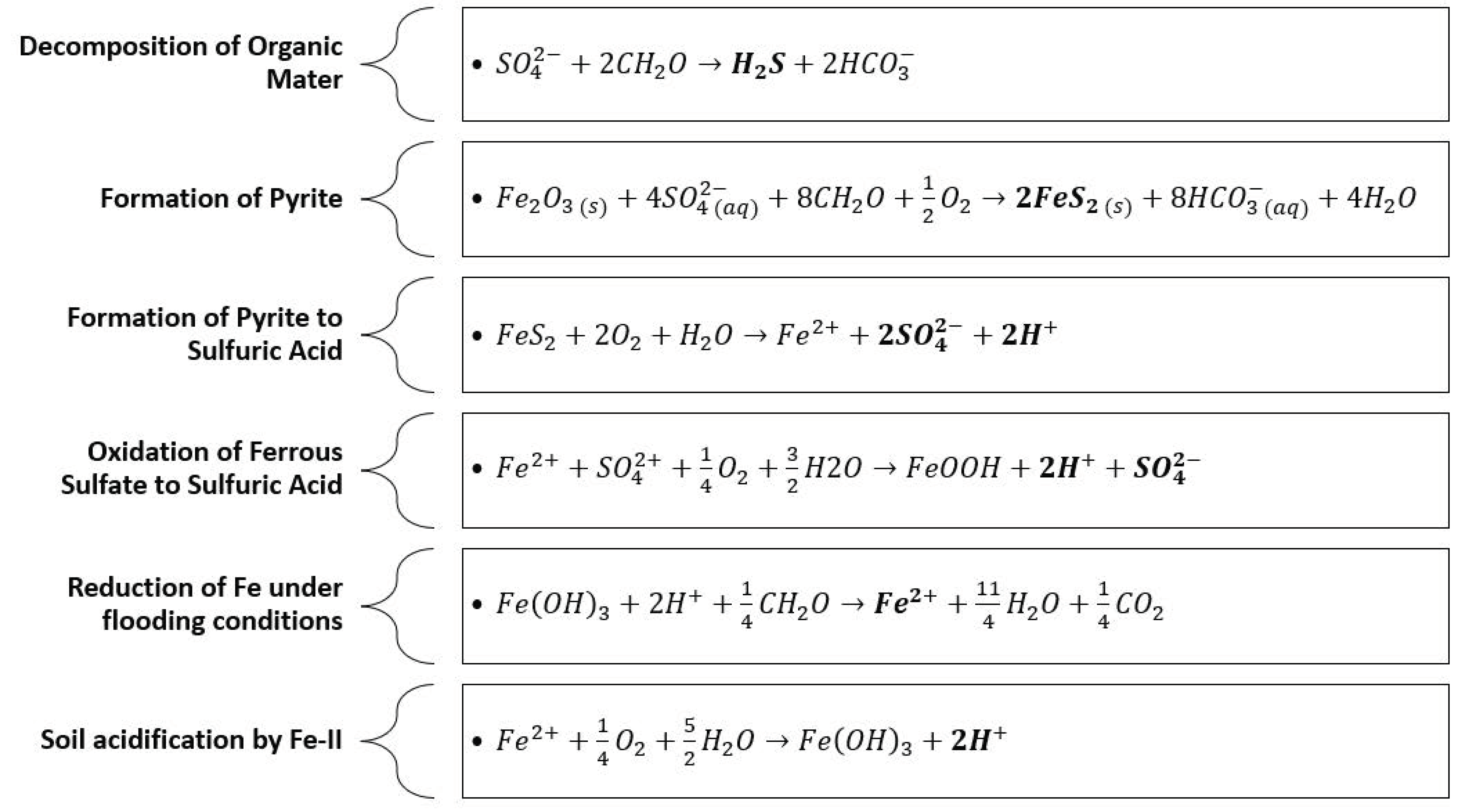
The scientific categories of tidal mangrove and associated mangrove fields are linked to the relative influence of the tides and of the brackish groundwater on rice production [61,64,65]. Likewise, Guinea-Bissau farmers categorize tidal mangrove fields within different sub-classes based on their specific age, function, fertility level (empirically assessed), and location in relation to the mangroves and the village (Figure 3 and Figure 4). Although all tidal mangrove fields could be called “bolanhas de tarrafe”, at present farmers apply this concept to only the highly fertile lower fields near to the main dike and the mangroves where high concentrations of salts can be found. The recently opened tidal fields of “bolanhas de tarrafe” where mangrove roots and stubs can still be found and which thus cannot be plowed are called new swamp fields (“bolanha novo” in Kriol). In these plots, there are generally no concerns about soil acidity due to sulfuric acids in the first soil horizons [63]. This is attributed to the extensive oxidation process in the soil profile, which leads to the formation of pyrite, resulting in the release of sulfuric acid ( S O 4 2 ) and H+ through the oxidation of Fe2+ (details are provided in Section 4.2). Additionally, over time, leaching of anions and cations to deeper soil horizons occurs [61,66]. The new swamp fields (“bolanha novo”) are the newest areas where farmers start planting (or directly sowing highly salt-tolerant rice varieties) 3 to 5 years after slashing the mangroves and building a main dike; this period is needed for rainfall to leach salts, thus naturally reducing salinity and toxicity caused by seawater cations. These are the most fertile locations among all the plots of the paddies [58]. However, these are the only sites that suffer from acidity problems caused by sulfuric acid due to their limited exposure to oxygen and leaching of cations and anions [63]. The start of ploughing of the new bolanha also depends upon the dominant mangrove species, as roots constitute physical barriers, mainly those of Aviccenia germinans and Languncularia sp. that take longer to rot [39].
There are two less common sub-categories of tidal mangroves, primarily used among Felupe and Baiote ethnic groups in some northern islands of GB (Figure 3 and Figure 4), known as “Nhatabas”, and “Ouriques de pisca”. The “Nhatabas” (called “ilhas” by the Balanta) are tidal mangrove fields (“bolanhas de tarrafe”) in terms of the soil physicochemical properties, located on remote islands, requiring the use of canoes for the transport both of workers and the rice harvest [67]. Finally, the fishing dikes (“ouriques de pisca” in Kriol) are ponds surrounded by dikes, reserved exclusively for the reproduction and growth of fish [68] (although they might have been former rice plots). Farmers facilitate the entry of saltwater, shrimps, and fish into these ponds by opening drainage pipes made from palm trunks [28,64].
In some villages, there is also an “associated terrace” (cabeça de bolanha in Kriol, meaning ‘head of the rice swamp field’) covered by wet or dry grassland. In the upland savannah woodlands/grasslands surrounding the households, where cattle, pigs, and goats roam, some farmers sow their rice nurseries at the beginning of the rainy season. Farmers can also use the mangrove fields to create nurseries, as in the south of GB, or more seldom perform direct sowing, as in southern GB (the Balanta ethnic group of the Cafine region and the Felupe/Baiote ethnic groups of the Cacheu region).

2.3. Areas and Yields

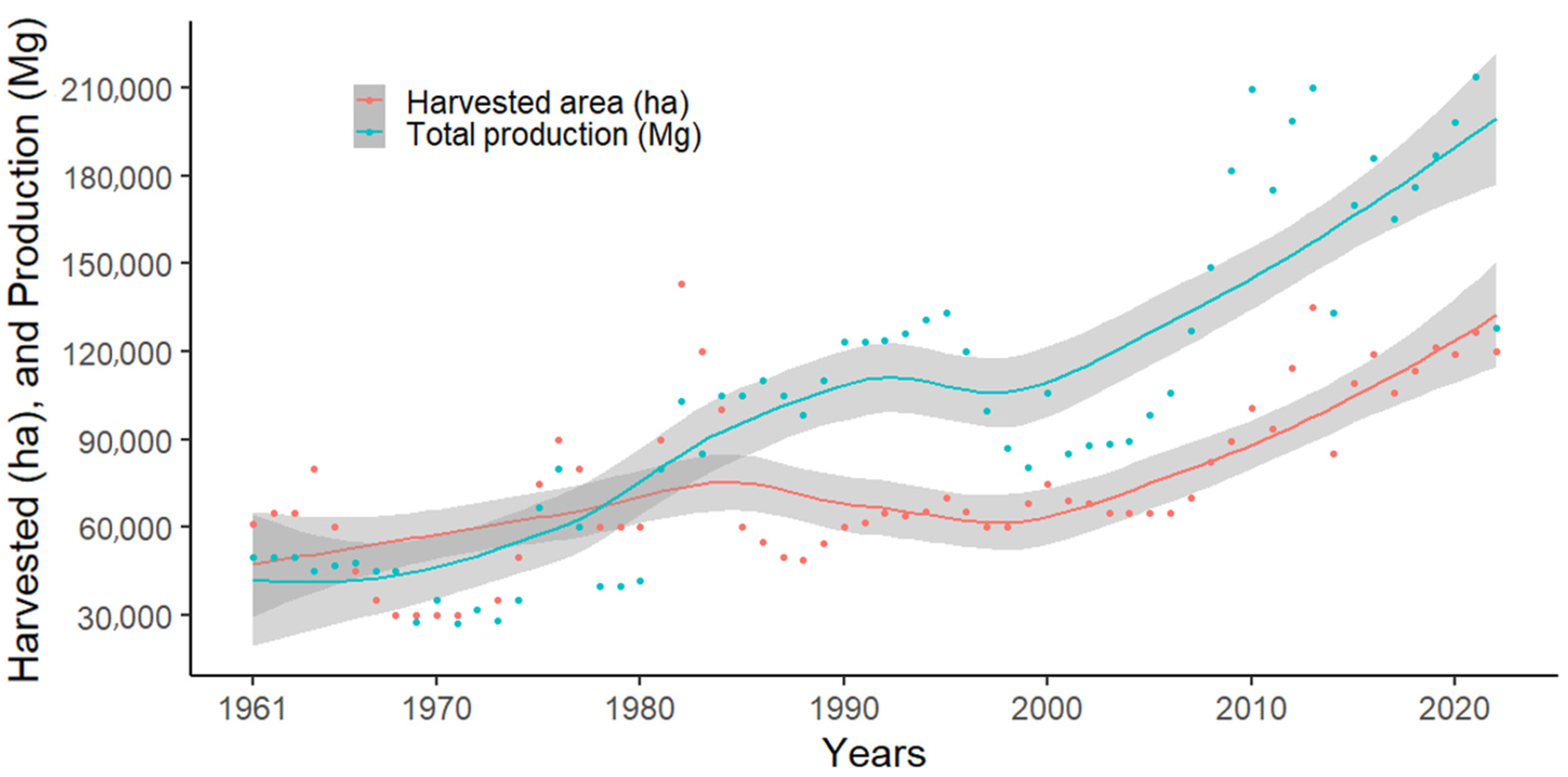
The official international statistics [69,70] show that in the past 60 years, total rice production in GB has been on an upward trend (Figure 5). However, these statistics are based upon rough estimates for the entire country. According to FAO and the World Bank estimates [69,70], rice production was lower in the 1960s and 1970s than in the most recent decade [71]. In the past 10 years, the average total area under rice cultivation in the country was 112,564 ha, with an annual average production of 180,749 Mg of rice. This is in line with the estimates of the African Union, which currently forecasts an approximate production of 182,544 Mg for the period 2010–2020 [72]. A similar increasing trend can be observed in relation to the area of rice harvested [69,70]. This indicates an active and strong expansion of rice production areas, despite the continuing dependence on rice imports [69]. This is likely to be due to a combination of factors, ranging from the active rebuilding of mangrove swamp rice fields’ infrastructure after the liberation war (1963–1974) and the expansion of new planting areas with higher soil fertility and water availability [73,74].
The rice yields in GB exhibit considerable temporal and spatial variability, the latter depending on the region and the rice production system. Table 1 shows the rice yield reported in several studies about rice cropped in upland locations and MSRP fields. The results show that the MSRPS outperforms the upland rice in all studies, with differences ranging from 15% to 60%. These differences indicate that the yield of the diverse rice production systems in GB is extremely different, largely due to the strong differences in agro-ecological characteristics between upland, inland valley, and MSRP fields.

2.4. Rice Crop Species and Varieties

Two species of rice plants have been identified in GB since colonial times, Oryza glaberrima and O. sativa. The first is a species native to Africa, where farmers have been domesticating and selecting varieties for 2000 and 3000 years [16,18,19,79]. In contrast, O. sativa is a species native to Asia and was introduced by the Portuguese and/or the Arabs during the colonial period in the 17th century [16,21]. These species have significant advantages and disadvantages in terms of their adaptability to the MSRPS (Table 2). The main reasons for their adoption are their productivity (sensu lato), their adaptation to social and cultural factors, and their tolerance to biotic and abiotic factors [20,25]. Over the years, farmers in GB have selected varieties from both species with the most suitable organoleptic and agronomic characteristics.
A significant number of rice varieties have been reported in GB over the past 70 years (Table 3). These varieties possess genetic characteristics of the O. sativa and O. glaberrima species, and even of interspecific hybrids [82]. The literature reports a total of 54 varieties (both farmers’ varieties and “improved” ones) identified in MSRP (Table 3) over the past 12 years [21,25,81]. There is a wealth of information that still needs to be thoroughly explored to accurately determine whether different names correspond to the same rice varieties and whether the same name can correspond to different varieties. This is a challenge the country faces due to its wide diversity of ethnic groups with completely different languages, making it difficult to properly identify varieties.
The wide diversity of rice varieties in GB (Table 3) is the result of continually being selected based on farmers’ changing needs over time. The vast majority of farmers do not carry out mass selection before harvesting the grain to be used as seed for the next cropping season, and farmers permanently access and adopt seeds of new varieties through informal channels. Furthermore, natural interspecific hybrids as a result of spontaneous cross pollination have been found in smallholders’ fields [23]. Varieties are usually adopted by farmers based on agroclimatic conditions (soil physicochemical conditions, climate), post-harvest quality, and nutritional considerations [25,26,83]. Various local criteria are used when selecting rice varieties, including (a) nutritional quality and post-harvest characteristics (duration of digestion time, swelling capacity during cooking, taste, difficulty in threshing, processing characteristics (de-husking), time required for a given volume of rice to be fully consumed) and (b) both phenotypic and genotypic traits of the variety (growth cycle, yields, salt tolerance, plant height, tillering capacity, flood tolerance, drought tolerance, susceptibility to lodging and shedding, susceptibility to pests and diseases) [25,26]. In most villages, these two main sets of criteria are used, with the first category having more weight than the second. Furthermore, these criteria may vary depending on the topographical characteristics of the plots and the cultural practices in different villages across the country.
Table 3. Rice varieties’ common names reported in the literature for Guinea-Bissau from 1948 to 2023.
Years1948–19731974–19901991–20102011–2023
Varieties
  • Adusta
  • Amaura
  • Americano
  • Atanha
  • Atrobrunnea
  • Bandjulô
  • Cuncú béle
  • Cycliana
  • Cristal (Angola)
  • Dichroa
  • Dinqueri
  • Elongata
  • Feluge
  • Gambiel
  • Gilanica
  • Iacá
  • Ioncubá
  • Italica
  • Jambaram
  • Jambaram branco
  • Landjau
  • Malanotrix
  • Malicoió
  • Ménè
  • Mohóbè
  • Mutica
  • Ruio (Angola)
  • Openê
  • Poupa
  • Santi
  • Selho
  • Senco
  • Sepica
  • Some (Thome)
  • Tanha
  • BG 400 SLR
  • BG-380-2
  • BG400-2
  • BG400-SRI
  • Cablack
  • Iaca
  • IR15-19
  • IR2035-120-3
  • Rd15
  • RD15
  • RG380-2
  • ROHIB 15
  • ROHYB 6
  • Rok5
  • WAR1
  • WAR77
  • WAR77-55-2-2
  • WAR-81-2-1-1
  • WAR81-2-12
  • Abulai
  • Aninha
  • Atanham
  • Bandeira
  • Bêháma
  • Bentana
  • Berendugô
  • Bimbirim
  • Cataco
  • Catanha
  • Cáu
  • Caublac simples
  • Cablak
  • Caublac xau
  • Iácá pepel
  • Iácá tomáso
  • Iácá pami
  • Lóbsim
  • Mafanhi
  • Malmála
  • Malmom (N’conton)
  • Malu-malu
  • Malu-raça
  • Mamussu
  • Murungo
  • N’conto
  • Nhiue
  • Nhoquê
  • N’thanthé
  • N’uérique
  • Péra n’djubi
  • Kissidugo
  • Quissampena/Sampena
  • Rd15
  • Rok5
  • Santi
  • Silá
  • Sili
  • Socubá
  • Some/Thom
  • Spínola
  • Thom-dam
  • Thom-som
  • Thorno
  • Yaca-keba
  • Yacuncola
  • Yaka
  • Alaia
  • Aninha
  • Arica 06
  • Arica 07
  • Atanha
  • Baga-male
  • Bakungabu
  • Balenabu
  • Bamakabu
  • Barnonte
  • Batumpaiabo
  • Brasil
  • Bucar/Buré
  • Cablak/Caubla
  • Cataco
  • Catio
  • Djambaram/Jambaran
  • Djelele
  • Dus-cascas/4 cascas/Aferenqué
  • Edjur
  • Etelé
  • Iacai Adi
  • Iacai branco
  • Iacai Tomor
  • Iacai vermelho
  • Kataco
  • Loque
  • Malan-dan
  • Malmon
  • Malubrasa
  • Malu-dingo
  • Malu-N’daure
  • Malu-sauho
  • Mamusso
  • N’conto
  • N’conto branco
  • N’conto preto
  • N’dolo-cpoc
  • N’gel
  • Nerica
  • N’thanthé
  • RD15
  • Rok25
  • Rok5
  • Sampena/Quissampena
  • Seli/Sili
  • Thom
  • Yaca
  • Yaca branco
  • Yaca-saw/Xau
References[16,54,75,82,84][25,71,76,80,83,85][19,25,26,65,79,86][21,25,39,81]
Rice varieties may be classified based on the crop cycle duration: short-cycle varieties (>90 days after sowing (das)), medium-cycle varieties (115–125 das), and long-cycle varieties (>135 das) [16,21,25,65,79,81,85]. This depends primarily on the rice species, as O. glaberrima varieties tend to have a shorter growth cycle compared with O. sativa varieties [19,80,87]. Nevertheless, comprehensive data on phenological stages, the temporal intervals between these stages, the quantification of phenological stages based on cumulative growing degree days, and other pertinent factors are still missing. Understanding the phenological stages of these rice varieties and growth cycles is crucial for developing more precise agronomic recommendations. Therefore, rice varieties in GB lack comprehensive life-cycle characterization, particularly because there is limited evidence for defined phenological stages and growth durations.
As shown in the analysis above, rice varieties cultivated in GB have significant genetic variability. Therefore, genetic and agronomic studies are both essential to identify and fully characterize the local varieties used specifically in the MSRP agroecosystem. This information will support adequate agronomic recommendations in times of socio-environmental changes, particularly in terms of water scarcity and salinity issues.

3. Salinity and Salt Management in the MSRPS in GB

3.1. Base Concepts

Soil salinity is an excessive accumulation of soluble salts (K+, Ca2+, Mg2+, Cl, and SO42−) and/or exchangeable sodium (Na+) in the rhizosphere or root zone [88]. Salinity in agricultural waters and soils is ascribed to both hydro-geological and anthropogenic mechanisms. Soil salinity problems occur in a variety of climatic conditions but are most evident in arid and semi-arid climates where rainfall is insufficient to leach accumulated salts in the root zone of crops [89].
Secondary salinity became an adjunct of irrigated agriculture since it charted an almost similar path to the commissioning of several irrigation schemes [89,90]. Major types of soil salinization include shallow groundwater-associated salinity, transient dryland salinity, irrigation-induced salinity [89,91], and the intrusion of saltwater from the sea [89].
High levels of soluble salts in the soil affect its physicochemical properties, causing osmotic changes in soil water, namely, increasing the osmotic potential, which leads to a reduction in plants’ water uptake, directly decreasing the plant growth rate and consequently leading to a decrease in crop production [89,91,92,93,94,95,96]. High sodium or low calcium levels in the soil or water affect the soil permeability and may cause crusting hazards. This reduces the rate of water infiltration into the soil to such an extent that not enough water is able to infiltrate and to refill the rootzone, thereby failing to provide the plant with an adequate water supply [92,93,95,96].
In sodic soils, clay dispersion occurs when the electrolyte concentration falls below the clay flocculation value. Sodium-affected soils that have low salinity have low structural stability, low hydraulic conductivities, and low infiltration rates. These poor physical properties result in reduced crop yield caused by the combined effect of poor aeration and reduced water supply. Low infiltration rates can also lead to severe soil erosion, particularly under heavy rain conditions [97].
The accumulation of salts in the soil leads to chemical imbalances within the soil matrix, subsequently giving rise to nutritional deficiencies in plants [98]. When the concentration of salts in the soil solution reaches a critical salinity level, called threshold salinity [99], it causes severe water deficits in plants, restricts plant growth, and can result in plant death [50]. Specific toxicity effects may occur in plants, mainly in woody perennials, in the presence of certain levels of chloride, sodium, and boron [89,92,93,94].
In saline soils, pH and acidity can also adversely affect plant growth. Soil acidity is primarily caused by an increase in the concentration of H+ ions [97,100]. In tropical soils, the primary cause of acidity is the hydrolysis of Al3+, whereas in soils with anoxic conditions and high organic matter content, acidity is directly caused by the release of H+ [100,101]. In general, saline soils tend to have alkaline pH values (pH > 7), and this may lead to issues with nutrient solubility in the soil solution. However, this condition can change if other chemical compounds are present that can significantly reduce the pH, such as sulfates [40]. Extremes in soil pH (whether high or low) directly impact nutrients’ solubility, consequently diminishing essential nutrient uptake by plants [102]. Both conditions exist in mangrove soils, mainly in soil with good oxygenation and active redox changes (bolanha novo). All these issues impact rice growth and yield.
The salinity quantification in the soil solution is easily determined via the electrical conductivity (EC) measurements evaluated in 1:2 or 1:5 (soil:water extract), and in soil saturated paste extract. Soil sodicity is based on the determinations of the exchangeable sodium percentage (ESP) or the sodium adsorption ratio (SAR) [50,103].
Salinity-affected soils are classified into saline, alkali, and saline alkali, based on ESP and EC [88]. Saline soils are those having an EC in saturated paste extract above 4 dS m−1 and an ESP < 5% [103,104]. Sodic soils present a high concentration of sodium, as indicated by an ESP > 15% and EC < 4 dS m−1. Saline sodic soils exhibit both high EPS (>15%) and high EC (>4 dS m−1) [104,105]. If the system has high sodium concentration (ESP > 15%) and low EC (<4 dS m−1), there is a high probability of soil structure loss due to clay particle dispersion [98].
Salinity management strategies usually aim to prevent accumulation of salts in the root zone to levels that limit root water uptake, controlling salt balances in the soil–water system by preventing continuous accumulation in the root zone and minimizing the hazardous effects of salinity on crop transpiration and consequently on crop growth and yield. Under saline conditions, irrigation should aim at maintenance of sufficiently high soil water potential and cause salt leaching in the soil profile [96,99]. However, under rainfed conditions, salt leaching occurs through precipitation, the timing of which may limit the suitability of the soil for crop production and/or sowing [96].
Nowadays, remote sensing instruments and aerial photography are used to map salinity because it is impractical to directly measure root zone EC over large areas. The FAO has provided a world map of soil salinization, the GSASmap, derived from a harmonized world soil database [106]. Unfortunately, this information is not available for GB, as no studies have been conducted in the country that could provide such information, and this is therefore a research gap that needs to be closed.

3.2. Salinity in the Bolanhas of the MSRPS

The impact of salinity represents one of the challenges to MSRP across West Africa. Studies have indicated that drought (33%), iron toxicity (12%), cold (7%), and salinity/sodicity (2%) are the most prevalent and significant stresses affecting rice crops in Africa [37,87,107]. Plants exhibit a significant adaptive response to cope with water loss by enhancing stomatal closure, thereby reducing CO2 exchange, impeding photosynthesis, and, thus, reducing yield [108,109]. Furthermore, evapotranspiration exacerbates the salinity effect, because water can mobilize cations from deeper soil layers into the upper layer near the rhizosphere.
Abiotic stress caused by salinity inhibits rice growth. The soils where MSR is cultivated are alluvial, formed by the deposition of sediments by seawater flows that naturally introduce salts into the system [66,110,111]. These areas are highly saline and support rice growth only during the rainy season when a period of lower toxicity occurs [12]. Maximum concentrations in some plots in GB were found to be between 195.8 and 5599 cmol(+) Na per kg soil and had an electrical conductivity (EC) of 53.75 mS cm−1 [63]. During the rainy season, salt concentration can drop to levels below 5 mS cm−1, allowing weeds and rice to grow [17,112]. This period represents a strategic phase for farmers to take advantage of these specific moments to grow rice. During the dry season, certain plots adjacent to mangroves and saltwater are used for extracting salt, especially intended for culinary purposes.
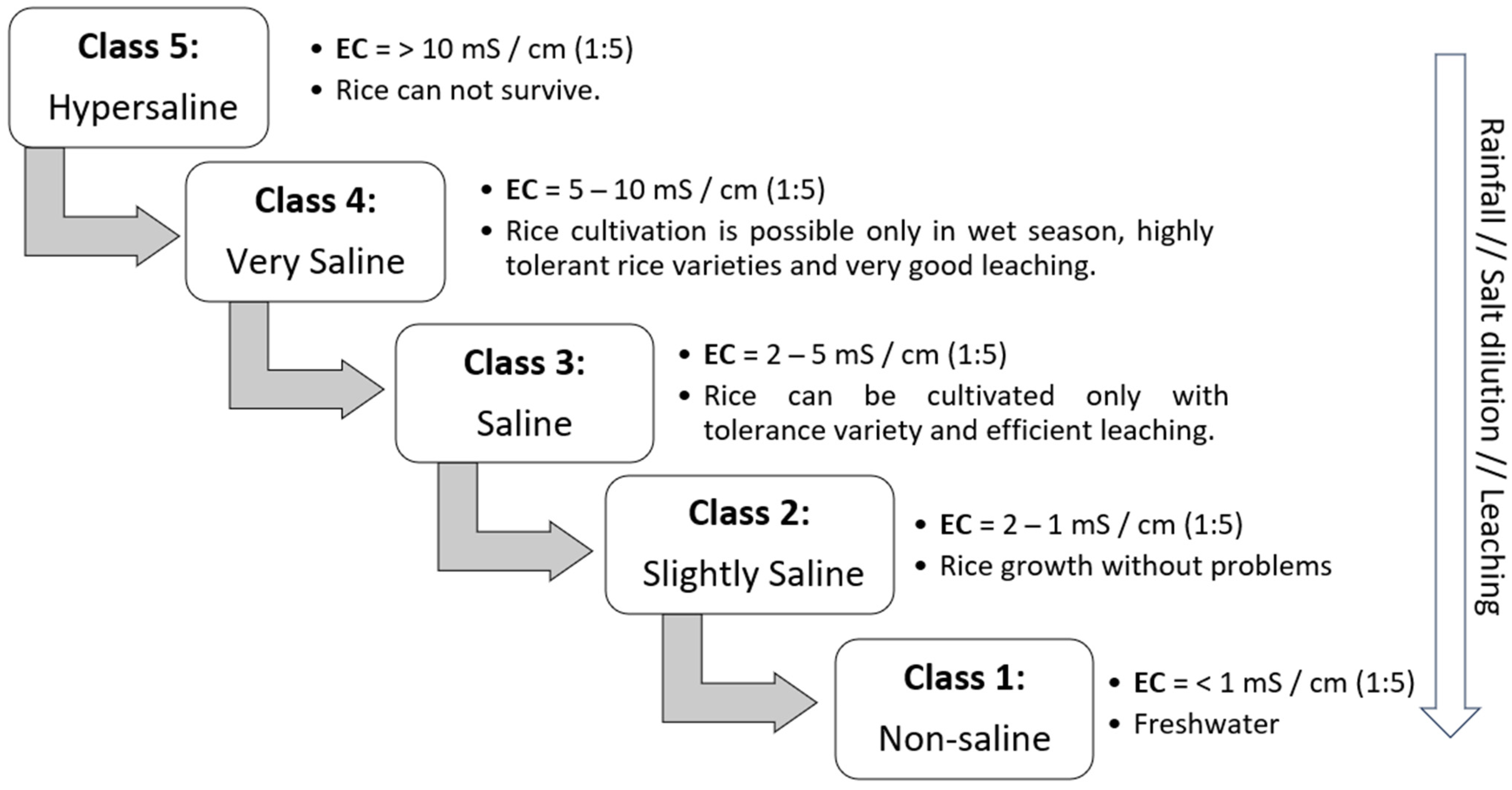
Due to the specificity of the MSRPS conditions, a different classification for soils affected by salinity was proposed [61]; the classification is based on EC (measured in 1:5 soil water suspension) and on the suitability of the soil for rice production, as depicted in Figure 6. These systems are defined by their status at the end of the dry season, particularly at the beginning of the rainy season [61]. It has been found that rice cultivation can thrive in Class 1 (non-saline) and Class 4 (very saline) soils. This can be achieved by using salt-tolerant rice varieties and ensuring adequate rainfall to facilitate leaching and reduce soil cation levels.
As previously stated, the MSRP in GB is determined by initial and final conditions and their effects on soil salinity concentrations. Due to the different initial salt concentrations in different plots, these conditions are not uniform everywhere [63,113] and depend on the amount of retained fresh water, resulting in additional dilution of salts as the MSRPS typically lacks proper drainage. Some reports have found that in mangrove systems in Nigeria, the spatial distribution of salinity is related to nutrient relationships and textural gradients [110]. The initial rainfall, depending on the amount of water, may also favor the leaching of some salts to deeper horizons, possibly leading to their accumulation in the groundwater. Assessment of the initial salt concentration is performed by farmers when they start planting the rice. Due to the lack of appropriate tools, farmers use biological (such as the presence of certain weeds) and physical (such as water temperature and the taste of the water) indicators. Comparable indicators have been documented in rice production in India [114].
The final state of the rainy season has a direct impact on crop yield since salinity can influence the critical phenological stages of rice plants. The final phenological stages of rice (R5–R7) are crucial for productivity, as stress during this period can directly affect the yield [29,40,60,115]. This happens every year when the plots revert to their original conditions. This typically occurs within two months after the last rainfall. At this time, water evaporation and crop transpiration increase the salt concentration in the plot, resulting in stress for non-tolerant rice varieties [12,116,117]. Some authors have reported that salinity is the most limiting factor in rice production in GB [77]. For this reason, farmers in the northern region of the country strive to store and maintain the maximum amount of water in the plots. There are currently no regional studies on water–salt balance, osmotic effect on rice plants, and evapotranspiration corresponding to the varieties of MSRP found in GB. For this reason, some authors recommend conducting regional studies on soil salinity in MSRPS [61,115].
Only a few studies have reported on soil water balance and salt movement [61,115] and only one of these focused on GB [61,115]. Therefore, there is a research gap regarding the adequate characterization of the MSRPS in terms of the dynamics of salts during both the rice season and the offseason, which is essential for establishing an appropriate schedule for the timely commencement of rice production in each region/type of field.

3.3. Salinity and Water Productivity in the MSRPS

According to the recent review by Minhas et al. [96], the relationship between plant growth and heterogeneous salinity in the root zone is complex. Thus, plant growth responds to the weighted-mean salinity of the root zone, as well as to the site-specific response of the roots and their ability to uptake water from the soil. Plants expend more energy to extract water from saline soils due to the high affinity of salts for water, and therefore, growth and yield are reduced.
Several studies have shown that crop yield and transpiration are less sensitive to low osmotic potential than to low matric potential (e.g., [118]). Under saline conditions, many plants can partially compensate for the low osmotic potential of soil water by building up higher levels of internal solute. This occurs through the absorption of ions from the soil solution and through the synthesis of organic osmolytes. However, the synthesis of organic osmolytes requires the expenditure of metabolic energy, which affects plant growth by reducing it under saline conditions. Reduced plant growth affects transpiration through the reduction in ground cover.
Aiming at assessing the reduction impacts of both soil and water salinity on crop evapotranspiration and yield, empirical salt-tolerance response functions have been developed for several crops, including rice [99]. These functions allow yield reduction to be defined as a function of total soil solution salinity, based on EC. The derived functions combine yield–salinity equations [92] with yield–ET equations [119]. The resulting equation provides a first approximation of the reduction in evapotranspiration expected under various salinity conditions and has been widely used in field conditions (e.g., [120,121,122]). Crop yields remain at potential levels until a specific threshold of electrical conductivity of the saturated soil water extract (ECe threshold) is reached [99,118]. Once the average ECe of the root zone exceeds this critical threshold, yield is assumed to decrease linearly in proportion to the increase in salinity [118,123]. The rate of yield decline with increasing salinity is usually expressed as a slope, b, with units of % yield decrease per dS m−1 increase in ECe. This is because not all plants respond similarly to salinity, as some crops are better able to make the necessary osmotic adjustments that allow them to extract water from a saline soil, or because they may be more tolerant to some of the toxic effects of salinity. According to the salt tolerance scale, rice is a sensitive plant and therefore does not tolerate high ECe. The ECe threshold for rice is 3 dS m−1 [99,118]. As discussed by [124], this ECe threshold presents errors and further research is needed to reduce the uncertainty, particularly when using salt-tolerant varieties. In addition to this piecewise linear function, various non-linear models have been proposed to relate crop yield to salinity [125]. Several authors (e.g., [118,123]) have stated that the effects of soil salinity and water stress are generally additive in their impacts on crop evapotranspiration and, therefore, in terms of crop growth and yield.
On the one hand, there are steady-state models which assume that salt concentrations in soil water are almost constant for a given location and time period, allowing a simple representation of soil salinity and plant growth conditions. For example, the SIMDualKc model, which applies the FAO dual-crop coefficient approach to partition crop evapotranspiration into crop transpiration and soil evaporation, uses a steady-state salinity approach and computes the soil water balance daily using transient information [120,123,126], allowing appropriate water management and irrigation in saline/sodic environments. The SALTMED model [127] constitutes another example this precise approach [99] for computing the soil water balance under salinity conditions.
On the other hand, there are transient state models that simulate changes in soil water content and salinity in the root zone caused by irrigation, rainfall, soil heterogeneity, and management options. These changes may refer to the timing and amount of irrigation, variable soil salinity conditions, variable crops and crop salinity tolerances, and variable irrigation water quality, including rainfall. This group of models includes, among others, UNSATCHEM [128], SWIM [129], SALTMOD [130], SALTMED [127], SWAP [131,132], and HYDRUS [133]. Unfortunately, we have not found any salt modelling study related to rainfed rice, mangrove swamp rice, or any rice–salt modelling studies for GB or on the African continent.
As previously discussed, the MSRPS system in GB has a high concentration of soluble salts in the soil. In addition, there are no irrigation systems or other freshwater sources available [29]. Therefore, rice production is limited by the amount of rainfall, which is responsible for leaching salts to deeper layers [134]. Effective freshwater collection and management ensure rice production and, consequently, the high productivity of collected rainwater. However, there is no information about the water and salt balance in the system to improve farmers’ harvesting schedules. Therefore, such information is required to adequately design strategies and practices that enable better control of salinity and thus improve farmers’ livelihoods.
To evaluate the performance of different rice farming systems, such as the MSRPS, and develop practices that result in higher yields and/or water savings, it is important to use indicators such as water productivity. This type of indicator allows different cropping systems to be compared. The physical water productivity (WP, kg m−3) is defined as the ratio of crop yield to the total water use (TWU) required to achieve the harvestable yield, expressed as kg m−3 [135,136,137]. The TWU is specified by the sum of four factors that quantify an approach to the water consumed; thus, water productivity is computed as:
W P = γ a P + S W + C R + I
where:
γ a : total harvested grain (kg)
P: seasonal rainfall amount (m3)
S W : variation in soil water storage in the root zone from planting to harvest (m3)
C R : capillary rise or groundwater contribution from a shallow water table (m3)
I : total seasonal irrigation amount (m3)
As already mentioned, in saline soils, despite good agronomic management, the potential crop yield is not achieved and therefore the WP is reduced. Frequently, the WP denominator (Equation (1)) in MSRP does not take irrigation into account because it is not used. The reduction in water input is expected to be less than the reduction in yield, resulting in low WP [138,139,140].
Under salinity conditions, an additional fraction of water is required to make the soil productive. Normally, irrigation water is increased by the leaching fraction [96,99]. Thus, the term TWU in Equation (1) quantifies additional terms associated with salinity-induced stress on the crop [135,137]. First, E T c   a c t is the seasonal actual evapotranspiration (when cropped under salinity and other stresses such as water). Second, L F quantifies the volume of water used to leach the salts from the rhizosphere. Third, N B W U is the water not beneficial for the crop, meaning the excess water that flows beyond the root zone (deep percolation or drainage), runoff from fields, water losses due to evaporation, and wind drift from sprinkling in irrigated systems. Therefore, WP quantifies the total production achieved based on the sum of three main factors, as follows:
W P s = γ a E T c a c t + L F + N B W U
where:
W P s a l t : water productivity in saline sites (kg m−3)
γ a : total harvested grain (kg)
E T c a c t : seasonal actual crop evapotranspiration (m3)
L F : water used for leaching salts from the root zone (m3)
N B W U : non-beneficial water use (m3)
In GB, this WPsalt concept is most applicable to the MSRPS due to the presence of salt. However, no information is available to account for the losses in non-beneficial water use (N-BWU); these are mainly due to evaporation of paddy water and in very few cases due to system drainage [140]. Runoff is commonly null unless precipitation events are high and in extreme cases may lead to the destruction of the dikes. Rice yield under salinity conditions may be improved through the implementation of breeding strategies which will increase WPsalt.
As discussed by Zwart [141], comparison of different rainfed cropping systems based on water productivity indicators must be performed with caution and non-manageable factors should be excluded. High WP values obtained from non-saline soils or a saline shallow water table cannot be set as a benchmark value for a rainfed rice system; this means that regional or local optimized WP values should be used.
Essentially, constraints on rice yield within the MSRPS, and consequently on rice WP, are mainly related to challenges in efficient water management practices that enable soil salinity control. Every farmer must work closely with his neighbors to produce rice and gain a good understanding of water dynamics (through endogenous knowledge and informal networks of kin and kith) to ensure a successful rice harvest every year [142].
Due to the lack of information regarding local mangrove swamp rice yield, salt balance, and seasonal rainfall amounts, there are, to our knowledge, no studies available about WP estimates in GB. Furthermore, we did not find any study on water productivity associated with mangrove swamp rice affected by salinity on the African continent.

4. General Soil Properties, Taxonomy, and Topography in MSR Fields

MSR fields have different physicochemical soil properties and levels of anoxia compared with former mangrove soils. The latter are considered to be high-sulfur environments with a notable presence of clays and salts [40]. However, despite having the same pedogenic formation, bolanhas’ soils are distinguished by high oxidation levels that allow the growth of plants susceptible to salinity [63]. This allows the development of new soil horizons characterized by different chronologically deposited materials [38].

4.1. Soil Taxonomy in Associated Tidal Mangrove Fields and Tidal Mangrove Terraces

In general, GB presents three main soil categories in terms of soil physicochemical properties. The ferrallitic and ferruginous (non-hydromorphic) soils, in which a high concentration of iron predominates, are red in color and occur in upland areas. The hydromorphic soils, which include both marine alluvial (halo-hydromorphic, as those of the bolanhas salgadas) and continental (grey, alluvial and terrace, gley, humic–gley) soils, characterized by long periods of anoxia and the presence of gley horizons [64,110,111]. Finally, the lithic soils are characterized by the presence of rocks and consolidated materials in their horizons [111]. A clear toposequence is observed in many villages (Table 4), with hydromorphic soils (bolanha soils) occurring alongside ferrallitic soils (villages’ upland soils). These ferrallitic soils are used for growing cash crops such as cashew, vegetables, and for rice nurseries.
Gleization soil conditions are prevalent in mangroves and plots soils, along with high concentration of sulfites and sulfates and a significant variability in soil organic carbon (SOC) concentration. Reduction conditions are commonly observed in mangrove soils [111]. This extends across the entire soil profile, particularly within the first 150 cm of soil depth. In contrast, bolanha soils are predominantly characterized by annual fluctuation in groundwater, with depths ranging from 30 to 150 cm below the soil surface [63]. Soil taxonomic classifications reported for mangrove and bolanha soils are categorized based on the presence of sulfates and sulfites, horizon development, and organic matter content (Table 4). Thus, this variation is observed across the entire toposequence (tidal mangroves, associated mangroves, and old bolanha fields), including mangrove areas and villages. In addition, certain locations have been reported to have low concentrations of SOC derived from marine carbon [59]. In this context, the deserted plots showed a significant decline across the soil profile compared with mangrove soils and new plots [59,63,117].
The design of Guinea-Bissau’s MSR plots varies depending on agroecological differences and the cultural practices of each ethnic group for water management, resulting in changes in the physicochemical properties of the soils. Differences in plot designs exist between the southern and northern regions of the country, with ethnic groups determining the sizes of plots based on the amount of stored fresh water they want to harvest (Figure 7). In the southern and central parts of GB, farmers construct dikes with significantly larger dimensions than those in the north. This is due to the soil texture potentially facilitating the construction of larger dikes and deeper primary drainage channels (Figure 7A), attributed to the clay deposits from alluvial sediments in the soil profile [63,111]. In addition, the high rainfall levels lead farmers to modify internal drainage systems at the plot level to remove salts and increase leaching during the first rains [28,82]. For example, southern farmers design internal drainage systems (without outlets) within plots, while farmers in the north do not implement drainage systems to maintain a consistent water level within the plot [64]. This has a significant impact on the salt concentration in the plots, as farmers in the south manage to flush out the salt present in the upper soil layers with the first rainfalls. Through the dilution of salts and their transport to small drainage systems without outlets (Figure 7A), farmers have a convenient method to open the plot and discharge the saline solution before soil tillage.
Soil fertility is significantly influenced by proximity to tidal mangrove areas, as these soils have higher accumulation of SOC. This is related to the quantity of organic materials present, which mineralize over time and release a significant amount of nutrients that benefit the crop [58]. Due to the decline in SOC occurring in old plots [59,63], farmers in GB frequently tend to develop new mangrove swamp fields (Figure 7C), with the aim of finding more fertile and highly productive areas for growing rice. However, as previously mentioned, the new plots (bolanha novo) are the only areas with high concentrations of salts and sulfuric acids in the first surface layers of the soil. Due to their active oxidation state, this can potentially cause serious problems for rice growth. This is different from bolanha de tarrafe and bolanha de metade fields (plots located in the middle part of the paddies far from the mangroves), as these have undergone prolonged oxidation. Many of those salts, sulfites, and sulfates were leached by rainfall and settled in deeper horizons, where they do not affect rice growth [63].

4.2. Acidity Formation in Tidal Mangrove Soils

Sulfuric acids in the soils of MSR fields start affecting the crop in the early stages of the new plots (the first 3–5 years). New plots are the most vulnerable sites because they initiate the desalination process and exhibit active pedochemical acidification (Table 4, Figure 8). These chemical processes depend on the amount of rainfall in the system, as fresh water catalyzes chemical processes and toxic compounds such as sulfuric acid (2SO42−), hydrogen sulfite (H2S), pyrite (2FeS2), reduced iron (Fe2+), and iron monosulfite (FeS) are leached into deeper soil layers [40,60,77]. Within the dynamic systems of oxidation and reduction, pyrite and sulfuric acid are formed and organic materials decompose (Figure 8). These processes can increase soil acidity, resulting in extremely low pH values (<3.5), reducing the availability of various nutrients to plants (N, K, Ca, Mg, P, Zn) and causing toxicity (Al3+, Fe2+) in the soil [40,87]. However, in some tidal mangroves (bolanha de tarrafe) and associated mangroves (bolanha metadi) these processes only occur at deeper horizons where they do not affect the plant’s root system [59,61,63,111]. In summary, villages in the northern and southern regions face problems of sulfuric acid toxicity especially in “bolanha novo”, with some “bolanha de tarrafe” occasionally affected by a strong influence of groundwater levels and tides [117].

5. Rainfall Patterns and Farmers’ Agronomic Practices Related to Water Management in the MSRPS

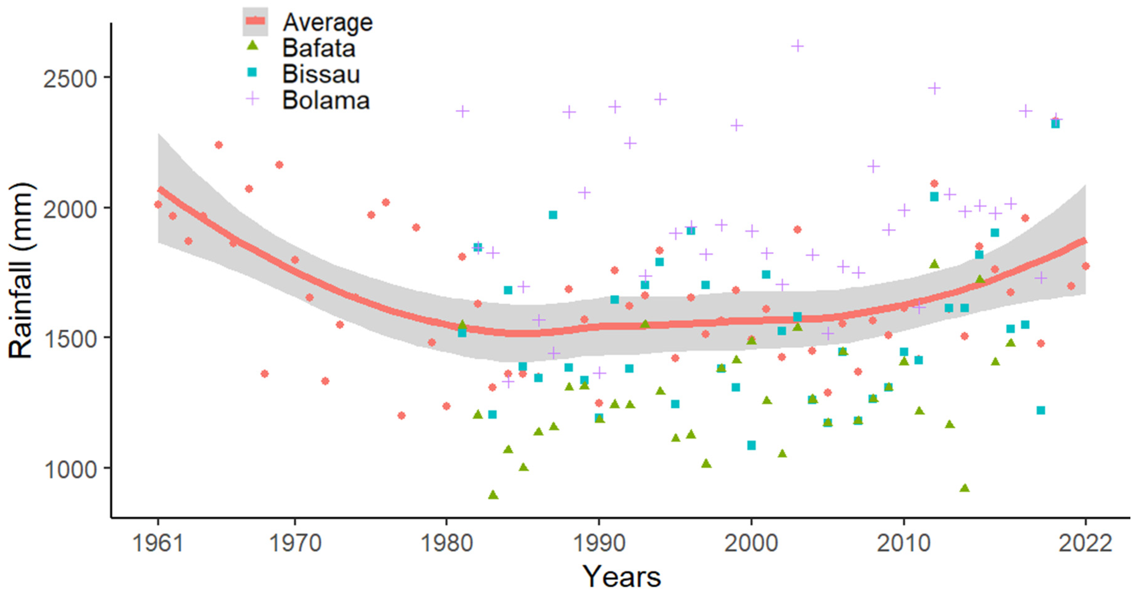
The rice production cycle in GB is constrained by the rainy season (onset and duration and length of dry spells) and the accumulated rainfall. Fresh water availability is the limiting factor for rice production across the country, especially in the MSRPS. The system relies on salt leaching and substantial water accumulation to ensure a complete crop cycle. Recent rainfall reports have shown that rainfall patterns are heterogeneous [41,143]. In the period from 1961 to 1985, there was a significant decrease in rainfall in the country (Figure 9). However, it is estimated that there has been a slight increase in annual rainfall of around 350 mm over the last 40 years (Figure 9). It is evident that the Bolama region consistently receives higher rainfall (1953 mm) than the Bafata (1276 mm) and Bissau (1524 mm) regions (Figure 9). For the other MSRPS regions, Tombali, Oio, and Cacheu, there is currently a lack of meteorological data. Some reports from the 1980s from Casamance/Senegal, close to the Cacheu Region, estimated that the average annual rainfall ranged from 1200 and 5000 mm [57], which is sufficient to support MSR growth.
Although most regions of the country receive sufficient rainfall for rice production, the main challenge lies in the uneven distribution of rainfall, which occurs within a relatively short timeframe [41]. This condition has a significant impact on rice growth. Rainfall is the most important factor in soil management, agronomic practices for rice cultivation, and the overall sustainability of the MSRPS. This creates significant challenges in managing the water and salt balance for rice production [144].
The manual preparation of the plots’ ridges depends on ensuring adequate soil moisture for tillage and, therefore, on the beginning of the rainy season [19,77]. Nevertheless, sufficient soil moisture is required to avoid problems with soil plasticity during plowing. There is no information available on the plasticity limits associated with soil tillage, although there are old reports of the use of mechanization for soil tillage in GB [145]. However, not all farmers have the necessary resources for mechanized operations, further exacerbated by limited access to large machinery on the plots [48]. Furthermore, heavy machines not only can compact the clay soils, but also create/increase weed infestations. In contrast, the manual plow is an affordable and sustainable tool that is accessible to all farmers in the villages [26,44,146], with which they can better control soil and weed conditions.
After soil tillage, farmers use two rice planting techniques: transplanting and direct seeding [26,39]. Transplanting is the most used technique as it ensures more uniform distribution of the plants and usually a higher productivity [23]. There is no exact date for planting in nursery, but generally it depends on the first rains, the individual farmer’s experience, soil moisture, and salinity levels at the sites. Direct seeding is most frequently used in bolanha de tarrafe, where the farmer identifies sites with good fertility and low salinity [26,30,77]. In this technique, some sites are plowed while others are simply planted or broadcasted with pre-germinated rice seeds [26,39].
The rice harvest usually begins in November and lasts until January, but it depends mainly on the schedule set by farmers, which depends mainly on each year’s rainfall distribution pattern in each village. There are agronomic and social problems in the villages preventing them from using short-cycle varieties. When rice is mature in only a few plots of a bolanha, it is very likely that the birds will concentrate their feeding there, destroying completely the potential harvest [16,27]. However, if all farmers harvest their rice at the same time, this problem is distributed among all plots [26]. Additionally, farmers must plan their harvests based on the water availability and salinity levels associated with their plots [19,55]. At the end of the crop cycle, the dilution of salts has a reverse effect (decreases again due to the end of the rains), leading to water and salt stress in rice plants [77,87]. In addition, evapotranspiration increases the salt concentration in the plots, leading to productivity problems [114,147].

The Use of Dikes, Bunds and Rigdes for Water Management in the Paddies

The main dikes are structures used to prevent tidal water from entering the paddies (Figure 10), while the bunds are used by farmers to collect and store fresh water inside the plots. At the topographic scale of the system, the slopes toward the mangroves are in general minimal and serve only to channel water from one plot to another. In addition, soil texture, the level of the groundwater, and the location of the plots within the paddies can either favor or hamper rapid accumulation of fresh water in the plots. Consequently, dikes play a central role in rice cultivation due to their control over leaching, oxygenation, and water storage in the plots, distinguishing them from the mangrove forests’ soils [29].
Bunds or secondary dikes surrounding the plots are the primary structure responsible for managing water levels in the MSRPS (Figure 7A4). These play an important role in ensuring an appropriate water depth during rice growth. However, when heavy rainfalls occur for several consecutive days simultaneously with spring tides, farmers may be unable to divert the excess water to other plots and then to the sea branch. This kind of situation led to the loss of a significant portion of rice nurseries in mangrove fields during 2022. There is no information about the distribution, quantity, and potential cumulative water content within the plots according to rain distribution, especially in relation to high tides (when it becomes impossible to drain excess fresh water through the drainage pipes to the river or sea branch).
Ridges play a critical role in the MSRPS by increasing soil fertility and reducing soil resistance to root penetration. Soil tillage in MSR plots promotes the incorporation of existing weeds, increasing the amount of SOC and triggering the mineralization process. Mineralization gradually releases nutrients, promoting the growth of rice plants and generating satisfactory yields. Additionally, ridges facilitate better rice transplanting by reducing soil compaction. Some studies have shown that ridges also promote the leaching of salts and toxic concentrations of soil acids [29,82]. The use of ridges is specifically aimed at improving the management of the soil physicochemical properties in rice production systems. In only a few cases, such as new plots, farmers do not use ridges (Figure 7C), because the soil is already high in fertility and lacks compaction [29]. They usually use these plots for rice nurseries or direct planting without tillage.
The bunds (Figure 10d) are the main base for rice harvesting, agronomic management, and water conservation in the plots. Proper management of fresh water in plots can ensure good harvests [19,82], effective pest control, and prevent salinization problems at critical phenological stages (R3–R6). The potential of the plots for storing fresh water is determined by the height of the bunds and the topography of the plot floor. After rice transplantation, farmers control the level of stored fresh water according to the plants’ height. They open the bunds to ensure that the water level does not submerge the seedlings, which could lead to their death. When the rice plants reach a size beyond the limit of the bund, it is closed completely to maximize water storage. Since fresh water is present within the bund, only rice and other Poaceae species with aerenchyma tissue can thrive in the waterlogging conditions. This prevents the growth of weeds that could affect rice cultivation. The ruptures in the main dikes are related to maintenance work, heavy rainfall, soil texture, and high tides. Soils with a high clay content offer increased rigidity to the dikes, enhancing their stability. Conversely, in regions characterized by sandy soils, dike maintenance requires substantial manual labor and constant attention [26,146]. In northern GB, there have been reports of dike maintenance problems due to labor shortages, resulting in saltwater intrusion into the polders and complete loss of rice production areas [67,148]. Dike maintenance is a collaborative task that requires strong cooperation and communication among farmers to prevent ruptures and facilitate quick repair during the rainy season.
In 2020, high rainfall over a short period combined with high and strong tides resulted in significant damage to many main dikes in several villages of GB [41]. This damage led to the intrusion of saltwater into the paddies, causing significant problems in rice production as farmers lost their harvests and substantial areas of rice fields and crops. Nevertheless, there is evidence from other countries that saline water intrusion can help eliminate weeds and increase soil fertility [116]; this practice was also used by GB farmers during colonial times. However, allowing the invasion of the brackish water during the dry season requires high rainfalls for salt leaching, as it could lead to hypersaline problems at planting sites [12,29,82,116].

6. Key Issues Overview and Future Research

With this review article, we aimed to characterize the mangrove swamp rice production system of Guinea-Bissau in relation to soil salinity, water use, and water productivity.
The biophysical description serves as the initial approach to comprehending the intricate dynamics of MSRP in GB. These dynamics are based on over 2000 years of agricultural experience and acclimatization, during which farmers have learned to manage this complex system to render it productive for growing rice. Through observations and experimentations over time, farmers have learned to manage the physicochemical characteristics of sites by using efficient water harvesting techniques and selecting appropriate rice varieties. This has enabled them to create specific swamp rice production areas (named bolanhas in Kriol), where they conceptualize the working methods, suitable varieties for growth, and the agronomic care required for each location (“Bolanha Belju”, “B. metadi”, “B. tarrafe”, “B. nobu”, and “Nhatabas—Tarrafe novo”). This information is characteristic to each village, as each region presents vastly different and highly complex biosystems in terms of climatic conditions, soils, and crop management needs. Several questions remain to be answered, such as: Why do farmers use drains on the swamp fields in the south, while these are not present in the north? Does salinity decrease if drains are used within the swamp fields? Can these drains help store a greater amount of fresh water? How are the initial salt conditions distributed in a MSRP field? When is the appropriate time for plants to grow without salt affecting their growth and productivity? There is a need to perform biophysical characterization of the plots and create maps of certain physicochemical soil properties. Due to the specificity of the system at each location, there is therefore a research gap that needs to be overcome. With this in mind, studies were developed in Cafine-Cafal in the south and Elalab in the north of GB and presented in the companion article by Garbanzo et al. [149].
The agronomic practices developed in the MSRPS in GB are tailored exclusively for rice cultivation, aiming for optimizing rice yield and water conservation in the “bolanhas”. A greater availability of fresh water in the plots would ensure rice production in the villages, as the crop would not face issues of saline stress within the system. These practices have been refined through generations of farmers, benefiting from their specialized experiences. However, under the current and future climate change scenario, particularly in terms of variability and reduced rainfall, these already vulnerable systems will become more fragile. This fragility results mainly from the increase in soil salinity due to reduced salt leaching by rainfall. It is fundamental to adapt crop management to the variable rainfall calendar, labor efficiency, and the soil hydro–salt dynamics. This set of constraints affects rice production, exposing communities in the villages to food insecurity and malnutrition. Therefore, further information to characterize the biosystems and rice varieties is essential to develop tailored practices that meet the specific needs of each village. This information is crucial for supporting decision making when planning sustainable management of grain production in the near future.
The main constraints to agricultural performance and rice productivity in GB have been identified and are related to insufficient and irregular distribution of rainfall, declining soil fertility, and poor water management. The information collected indicated the existence of:
  • A wide range of rice varieties with different names found in the MSRPS. Understanding the characteristics of each variety, particularly in terms of salt tolerance, could improve agronomic recommendations at the national level.
  • A lack of understanding of water dynamics in the MSRPS. This knowledge, obtained from field measurements and modelling, could facilitate the efficient planning of rice production cycles while minimizing problems related to toxicity and salinity.
  • A lack of knowledge about the salt balance, especially regarding the initial and final salinity conditions in different contexts. The development of a tool that allows to assess the hydro–saline balance in the MSRP is crucial to optimize the cultivation calendar for the timely start of each rice production season.
  • Limited information on soil fertility, nutrient dynamics, and their relationship to MSRPS productivity. Comprehensive chemical characterization of the soil and an understanding of nutrient dynamics could improve on-site nutrient management.
  • No information regarding the spatialization of physicochemical properties in swamp fields (“bolanhas”). Spatial mapping of soil properties could help identify areas with higher fertility, salinity, and the potential for improving rice productivity.
  • Insufficient studies on plasticity related to adequate soil moisture at the beginning of farming operations. Generating maps in this regard could provide farmers with valuable tools, allowing them to prioritize sites with optimal conditions for soil tillage. The companion article by Garbanzo et al. [149] developed soil consistency maps with the aim of supporting farmers in decision making.
  • A lack of studies on tidal dynamics, for the creation of an early warning system, and on main dike management. Providing information about extreme climatic events, monitoring and identifying vulnerable zones, and help with the dissemination of recent endogenous innovations in dike building and maintenance could help prevent saltwater intrusion and minimize losses in rice production.
  • A lack of continuous regional climate monitoring programs. Characterization of regional climatic variables could assist in agronomic calculation of rice water requirements in the MSRPS of GB. This would enable the development of early warning systems to support decision making in rice production.
  • Local constraints on balancing ecosystem sustainability with the food needs of coastal people, who feel urged to clear new mangrove areas to create rice fields even when there is a need to restore deforested areas to prevent dike ruptures and harvest failures. This implies that compensation mechanisms for poor coastal inhabitants must be created to protect ecosystem services in GB’s blue carbon environments.
  • External interventions or development projects that do not usually align with the local realities and the needs of farmers, leading to challenges in implementing sustainable practices.
  • Limited programs to restore desertified swamp fields. Initiating restoration efforts for these plots could include planting trees through the introduction of agroforestry practices and/or improving the conditions for reviving rice cultivation.
Overall, there is still a lot of progress to be made in terms of research relative to MSRPS conservation and management.

Author Contributions

Conceptualization, G.G., P.P. and M.d.R.C.; methodology, G.G.; software, G.G.; validation, M.d.R.C. and P.P.; formal analysis, G.G.; investigation, G.G.; data curation, G.G.; writing—original draft preparation, G.G.; writing—review and editing, P.P. and M.d.R.C.; visualization, G.G.; supervision, P.P. and M.d.R.C. All authors have read and agreed to the published version of the manuscript.

Funding

This research article was made possible thanks to the financial support provided by the European Union through the DeSIRA project Titled “Mangroves, Mangrove Rice and Mangrove People: Sustainably Improving Rice Production, Ecosystem, and Livelihoods. (Grant Contract FOOD/2019/412-700) (https://www.malmon-desira.com, accessed on 21 February 2024).

Data Availability Statement

Data will be provided upon request.

Acknowledgments

The authors acknowledge the support of the Fundação para a Ciência e a Tecnologia, Portugal, through the grant attributed to the research unit Forest Research Centre (CEF) UIDB/00239/2020, as well as the project LEAF—Linking Landscape, Environment, Agriculture and Food Research Centre (UIDB/04129/2020) of Associate Laboratory TERRA. Additionally, this research received support from the University of Costa Rica. The authors sincerely thank Marina Temudo for the thorough revision of the manuscript, and for all the support and friendship. Sincere thanks also go to Viriato Cossa, Merlin Leunda, Jesus Cespedes, Orlando Mendes, Matilda Merkohasanaj, and Joseph Sandoval for their invaluable support, insightful suggestions, and dedicated work in the villages of Guinea-Bissau.

Conflicts of Interest

The authors declare no conflicts of interest.

References

  1. Food and Agriculture Organization of the United Nations. FAO Rice Market Monitor. Available online: https://www.fao.org/markets-and-trade/commodities/rice/rmm/en/ (accessed on 10 October 2023).
  2. Kraehmer, H.; Thomas, C.; Vidotto, F. Rice Production in Europe. In Rice Production Worldwide; Springer International Publishing: Cham, Switzerland, 2017; pp. 93–116. ISBN 9783319475165. [Google Scholar]
  3. Mallareddy, M.; Thirumalaikumar, R.; Balasubramanian, P.; Naseeruddin, R.; Nithya, N.; Mariadoss, A.; Eazhilkrishna, N.; Choudhary, A.K.; Deiveegan, M.; Subramanian, E.; et al. Maximizing Water Use Efficiency in Rice Farming: A Comprehensive Review of Innovative Irrigation Management Technologies. Water 2023, 15, 1802. [Google Scholar] [CrossRef]
  4. Nie, L.; Peng, S. Rice Production in China. In Rice Production Worldwide; Bhagirath, S.C., Khawar, J., Gulshan, M., Eds.; Springer International Publishing: Berlin, Germany, 2017; pp. 33–52. ISBN 9783319475165. [Google Scholar]
  5. Alberto, M.C.R.; Quilty, J.R.; Buresh, R.J.; Wassmann, R.; Haidar, S.; Correa, T.Q.; Sandro, J.M. Actual Evapotranspiration and Dual Crop Coefficients for Dry-Seeded Rice and Hybrid Maize Grown with Overhead Sprinkler Irrigation. Agric. Water Manag. 2014, 136, 1–12. [Google Scholar] [CrossRef]
  6. Diaz, M.B.; Roberti, D.R.; Carneiro, J.V.; Souza, V.d.A.; de Moraes, O.L.L. Dynamics of the Superficial Fluxes over a Flooded Rice Paddy in Southern Brazil. Agric. For. Meteorol. 2019, 276–277, 107650. [Google Scholar] [CrossRef]
  7. Oue, H.; Laban, S. Water Use of Rice and Mung Bean Cultivations in a Downstream Area of an Irrigation System in South Sulawesi in the 2nd Dry Season. Paddy Water Environ. 2020, 18, 87–98. [Google Scholar] [CrossRef]
  8. Fukai, S.; Mitchell, J. Factors Determining Water Use Efficiency in Aerobic Rice. Crop Environ. 2022, 1, 24–40. [Google Scholar] [CrossRef]
  9. Moratiel, R.; Martínez-Cob, A. Evapotranspiration and Crop Coefficients of Rice (Oryza Sativa L.) under Sprinkler Irrigation in a Semiarid Climate Determined by the Surface Renewal Method. Irrig. Sci. 2013, 31, 411–422. [Google Scholar] [CrossRef]
  10. Choudhury, B.U.; Singh, A.K.; Pradhan, S. Estimation of Crop Coefficients of Dry-Seeded Irrigated Rice–Wheat Rotation on Raised Beds by Field Water Balance Method in the Indo-Gangetic Plains, India. Agric. Water Manag. 2013, 123, 20–31. [Google Scholar] [CrossRef]
  11. Clerget, B.; Bueno, C.; Quilty, J.R.; Correa, T.Q., Jr.; Sandro, J. Modifications in Development and Growth of a Dual-Adapted Tropical Rice Variety Grown as Either a Flooded or an Aerobic Crop. Field Crops Res. 2014, 155, 134–143. [Google Scholar] [CrossRef]
  12. Zenna, N.; Senthilkumar, K.; Sie, M. Rice Production in Africa; Chauhan, B.S., Jabran, K., Mahajan, G., Eds.; Springer International Publishing: New York, NY, USA, 2017; ISBN 978-3-319-47514-1. [Google Scholar]
  13. Farooq, M.S.; Fatima, H.; Rehman, O.U.; Yousuf, M.; Kalsoom, R.; Fiaz, S.; Khan, M.R.; Uzair, M.; Huo, S. Major Challenges in Widespread Adaptation of Aerobic Rice System and Potential Opportunities for Future Sustainability. S. Afr. J. Bot. 2023, 159, 231–251. [Google Scholar] [CrossRef]
  14. Bos, D.; Grigoras, I.; Ndiaye, A. Land Cover and Avian Biodiversity in Rice Fields and Mangroves of West Africa; Altenburg & Wymenga: Dakar, Senegal, 2006; Volume 1, ISBN 9789058820341. [Google Scholar]
  15. van Oort, P.A.J.; Zwart, S.J. Impacts of Climate Change on Rice Production in Africa and Causes of Simulated Yield Changes. Glob. Chang. Biol. 2018, 24, 1029–1045. [Google Scholar] [CrossRef]
  16. Linares, O.F. African Rice (Oryza Glaberrima): History and Future Potential. Proc. Natl. Acad. Sci. USA 2002, 99, 16360–16365. [Google Scholar] [CrossRef]
  17. Penot, E. La Riziculture de Mangrove de La Société Balant Dans La Région de Tombali (Guinée-Bissau). In Dynamique et Usages de la Mangrove Dans les Pays des Rivières du Sud, du Sénégal à la Sierra Leone; Cormier-Salem, M.-C., Ed.; ORSTOM: Paris, France, 1994; pp. 209–222. ISBN 0767-2896. [Google Scholar]
  18. Da Silva, C. Os Ecosistemas Orizicolas Na Guiné Bissau. Comun. Intituto Invesigacion Científica Trop. 1993, 13, 367–388. [Google Scholar]
  19. Hawthorne, W. Nourishing a Stateless Society during the Slave Trade: The Rise of Balanta Paddy-Rice Production in Guinea-Bissau. J. Afr. Hist. 2001, 42, 1–24. [Google Scholar] [CrossRef]
  20. Kyle, S. Working Paper Rice Sector Policy Options in Guinea Bissau; Cornell University, Department of Applied Economics and Management: New York, NY, USA, 2015. [Google Scholar]
  21. Teeken, B.; Nuijten, E.; Temudo, M.P.; Okry, F.; Mokuwa, A.; Struik, P.C.; Richards, P. Maintaining or Abandoning African Rice: Lessons for Understanding Processes of Seed Innovation. Hum. Ecol. 2012, 40, 879–892. [Google Scholar] [CrossRef]
  22. Lea, J.D. (Zach) Applied Policy Analysis of the Rice Marketing Subsector of Guinea-Bissau. J. Int. Food Agribus. Mark. 1993, 4, 23–40. [Google Scholar] [CrossRef]
  23. Nuijten, E.; van Treuren, R.; Struik, P.C.; Mokuwa, A.; Okry, F.; Teeken, B.; Richards, P. Evidence for the Emergence of New Rice Types of Interspecific Hybrid Origin in West African Farmers’ Fields. PLoS ONE 2009, 4, e7335. [Google Scholar] [CrossRef]
  24. Nuijten, E.; Temudo, M.; Richards, P.; Okry, F.; Teeken, B.; Mokuwa, A.; Struik, P.C. Towards a New Approach for Understanding Interactions of Technology with Environment and Society in Small-Scale Rice Farming. In Realizing Africa’s Rice Promise; CABI: Cotonou, Benin, 2013; pp. 355–366. ISBN 9781845938123. [Google Scholar]
  25. Temudo, M.P. Planting Knowledge, Harvesting Agro-Biodiversity: A Case Study of Southern Guinea-Bissau Rice Farming. Hum. Ecol. 2011, 39, 309–321. [Google Scholar] [CrossRef]
  26. Temudo, M.P. Inovação e Mudança Em Sociedades Rurais Africanas Gestão de Recursos Naturais, Saber Local e Instituições de Desenvolvimento Induzido Estudo de Caso Na Guiné-Bissau; Universidade Técnica de Lisboa: Lisbon, Portugal, 1998. [Google Scholar]
  27. Teeken, B.; Temudo, M.P. Varietal Selection in Marginal Agroecological Niches and Cultural Landscapes: The Case of Rice in the Togo Hills. Agroecol. Sustain. Food Syst. 2021, 45, 1109–1138. [Google Scholar] [CrossRef]
  28. Cooper, S.; McConkey, S. Guinea Bissau. Pract. Neurol. 2005, 5, 184–185. [Google Scholar] [CrossRef]
  29. The Republic of Guinea-Bissau. Framework Convention on Climate Change; National Communication: Bissau, Guinea-Bissau, 2018. [Google Scholar]
  30. Röhrig, F.; Bougouma, K.; Schiek, B.; Ghosh, A.; Ramirez-Villegas, J.; Achicanoy, H.; Esquivel, A.; Saavedra, C.; Diekjürgen, D.; Grosjean, G. The Alliance of Bioversity and The International Center for Tropical Agriculture; World Food Programme; World Food Programme: Rome, Italy, 2021; p. 76. [Google Scholar]
  31. Secretary of State for Environment and Tourism. Fifth National Report to the Convention on Biological Diversity; Secretary of State for Environment and Tourism: Bissau, Guinea Bissau, 2014. [Google Scholar]
  32. Fernandes, R.M. O Informal e o Artesanal: Pescadores e Revendedeiras de Peixe Na Guiné-Bissau; Universidade de Coimbra: Coimbra, Portugal, 2012. [Google Scholar]
  33. Dias, G.A.; Vasconcelos, M.J.; Catarino, L. Examining the Socioeconomic Benefits of Oysters: A Provisioning Ecosystem Service from the Mangroves of Guinea-Bissau, West Africa. J. Coast. Res. 2022, 38, 355–360. [Google Scholar] [CrossRef]
  34. Ministry of Natural Resources and Environment. National Programme of Action of Adaptation to Climate Changes; Ministry of Natural Resources and Environment: Bissau, Guinea Bissau, 2006.
  35. Soullier, G.; Demont, M.; Arouna, A.; Lançon, F.; Mendez del Villar, P. The State of Rice Value Chain Upgrading in West Africa. Glob. Food Secur. 2020, 25, 100365. [Google Scholar] [CrossRef]
  36. Fofana, I.; Goundan, A.; Mangne, L. Impact Simulation of ECOWAS Rice Self-Sufficiency Policy; International Food Policy Research Institute: Dakar, Senegal, 2014. [Google Scholar]
  37. Balasubramanian, V.; Sie, M.; Hijmans, R.J.; Otsuka, K. Increasing Rice Production in Sub-Saharan Africa: Challenges and Opportunities. Adv. Agron. 2007, 94, 55–133. [Google Scholar] [CrossRef]
  38. Andriesse, W.; Fresco, L.O. A Characterization of Rice-Growing Environments in West Africa. Agric. Ecosyst. Environ. 1991, 33, 377–395. [Google Scholar] [CrossRef]
  39. Cossa, V. Experimentação Com Variedades e Densidades de Sementeira de Arroz No Agroecossistema de Mangal de Bolanha Salgada No Sul de Guiné-Bissau (Workshop); MALMON, Project EU_DESIRA: Bissau, Guinea Bissau, 2023. [Google Scholar]
  40. Sylla, M. Soil Salinity and Acidity: Spatial Variabily and Effects on Rice Production in West Africa’s Mangrove Zone; Wageningen University and Research: Wageningen, The Netherlands, 1994. [Google Scholar]
  41. Mendes, O.; Fragoso, M. Assessment of the Record-Breaking 2020 Rainfall in Guinea-Bissau and Impacts of Associated Floods. Geosciences 2023, 13, 25. [Google Scholar] [CrossRef]
  42. Andrieu, J. Land Cover Changes on the West-African Coastline from the Saloum Delta (Senegal) to Rio Geba (Guinea-Bissau) between 1979 and 2015. Eur. J. Remote Sens. 2018, 51, 314–325. [Google Scholar] [CrossRef]
  43. Temudo, M.P.; Oom, D.; Pereira, J.M. Bio-Cultural Fire Regions of Guinea-Bissau: Analysis Combining Social Research and Satellite Remote Sensing. Appl. Geogr. 2020, 118, 102203. [Google Scholar] [CrossRef]
  44. Martiarena, M.L.; Temudo, M.P. Endogenous Learning and Innovation in African Smallholder Agriculture: Lessons from Guinea-Bissau. J. Agric. Educ. Ext. 2023, 1–19. [Google Scholar] [CrossRef]
  45. Idris, O.A.; Opute, P.; Orimoloye, I.R.; Maboeta, M.S. Climate Change in Africa and Vegetation Response: A Bibliometric and Spatially Based Information Assessment. Sustainability 2022, 14, 4974. [Google Scholar] [CrossRef]
  46. Dore, M.H.I. Climate Change and Changes in Global Precipitation Patterns: What Do We Know? Environ. Int. 2005, 31, 1167–1181. [Google Scholar] [CrossRef]
  47. Sousa, J.; Campos, R.; Mendes, O.; Duarte Lopes, P.; Matias, M.; Rosa, A.P.; Mendes Fernandes, R.; Cruz, C.; Indjai, B.; Infande, A.; et al. The (Dis)Engagement of Mangrove Forests and Mangrove Rice in Academic and Non-Academic Literature on Guinea-Bissau—A Systematic Review Protocol. PLoS ONE 2023, 18, e0284266. [Google Scholar] [CrossRef]
  48. Cabral, A. Acerca Da Utilizaçao Da Terra Na Africa Negra. Bol. Cult. da Guiné Port. 1954, IX, 401–415. [Google Scholar]
  49. World Bank. Guinea Bissau: Unlocking Diversification to Unleash Agriculture Growth; World Bank Group: Bissau, Guinea Bissau, 2019. [Google Scholar]
  50. Machado, R.; Serralheiro, R. Soil Salinity: Effect on Vegetable Crop Growth. Management Practices to Prevent and Mitigate Soil Salinization. Horticulturae 2017, 3, 30. [Google Scholar] [CrossRef]
  51. Temudo, M.P.; Figueira, R.; Abrantes, M. Landscapes of Bio-Cultural Diversity: Shifting Cultivation in Guinea-Bissau, West Africa. Agrofor. Syst. 2015, 89, 175–191. [Google Scholar] [CrossRef]
  52. Temudo, M.P.; Santos, P. Shifting Environments in Eastern Guinea-Bissau, West Africa: The Length of Fallows in Question. NJAS Wageningen J. Life Sci. 2017, 80, 57–64. [Google Scholar] [CrossRef]
  53. Medina, N. O Ecossistema Orizícola Na Guiné-Bissau: Principais Constrangimentos à Produção Na Zona (Regiões de Biombo, Cacheu e Oio) e Perspectivas; Universidade Técnica de Lisboa: Lisbon, Portugal, 2008. [Google Scholar]
  54. Ferreira. Problemas e Perpectivas Do Desenvolvimento Rural Da Guiné; Universidade técnica de Lisboa: Lisboa, Portugal, 1968. [Google Scholar]
  55. Marzouk, Y. Histoire Des Conceptions Hydrauques Etatiques et Paysannes En Basse Cassamance, Senegal, 1960–1990. In Savoirs Paysans et Développement; Dupré, G., Ed.; Karthala-Orstom: Paris, France, 1991; Volume 1, pp. 61–97. ISBN 9786021018187. [Google Scholar]
  56. Mota, T. Guiné Portuguesa; Agência Geral do Ultramar: Lisboa, Portugal, 1954; Volume 1. [Google Scholar]
  57. Linares, O.F. From Tidal Swamp to Inland Valley: On the Social Organization of Wet Rice Cultivation among the Diola of Senegal. Africa 1981, 51, 557–595. [Google Scholar] [CrossRef]
  58. Merkohasanaj, M.; Cortez, N.; Goulao, L.; Andreetta, A. Characterisation of Physical-Chemical and Fertility Dynamics of Mangrove Soils from Guinea-Bissau in Different Agroecological Conditions Underlying Paddy Rice Cultivation Ao Cultivo Do Arroz. Rev. Cienc. Agrar. 2022, 45, 267–271. [Google Scholar] [CrossRef]
  59. Andreetta, A.; Huertas, A.D.; Lotti, M.; Cerise, S. Land Use Changes Affecting Soil Organic Carbon Storage along a Mangrove Swamp Rice Chronosequence in the Cacheu and Oio Regions (Northern Guinea-Bissau). Agric. Ecosyst. Environ. 2016, 216, 314–321. [Google Scholar] [CrossRef]
  60. van Oort, P.A.J. Mapping Abiotic Stresses for Rice in Africa: Drought, Cold, Iron Toxicity, Salinity and Sodicity. Field Crop. Res. 2018, 219, 55–75. [Google Scholar] [CrossRef]
  61. Sylla, M.; Stein, A.; van Breemen, N.; Fresco, L.O. Spatial Variability of Soil Salinity at Different Scales in the Mangrove Rice Agro-Ecosystem in West Africa. Agric. Ecosyst. Environ. 1995, 54, 1–15. [Google Scholar] [CrossRef]
  62. Naidoo, G. The Mangroves of Africa: A Review. Mar. Pollut. Bull. 2023, 190, 114859. [Google Scholar] [CrossRef]
  63. D’Amico, M.E.; Barbieri, M.; Khair, D.A.E.; Comolli, R. Mangrove Rice Productivity and Pedogenic Trends in Guinea Bissau, West Africa. J. Soils Sediments 2024, 24, 244–258. [Google Scholar] [CrossRef]
  64. Oosterbaan, R.; Vos, J. Rice Polders in the Acid Sulfate Soils of the Bolanhas in the Mangroves of Guinea-Bissau; International Institute for Land Reclamation and Improvement: Wageningen, The Netherlands, 1980. [Google Scholar]
  65. Penot, E. L’économie d’une Société Rizicole Traditionnelle En Pleine Mutation: La Société Balante de La Région de Tombali En Guinée Bissau; Education et Developpement Interculturels: Bissau, Guinea Bissau, 1992. [Google Scholar]
  66. Ukpong, I.E. An Ordination Study of Mangrove Swamp Communities in West Africa. Vegetatio 1995, 116, 147–159. [Google Scholar] [CrossRef]
  67. Temudo, M.P.; Cabral, A.I.R. Climate Change as the Last Trigger in a Long-Lasting Conflict: The Production of Vulnerability in Northern Guinea-Bissau, West Africa. J. Peasant Stud. 2023, 50, 315–338. [Google Scholar] [CrossRef]
  68. Van der Knaap, M. Rice-Fish Farming in Sub-Saharan Africa. FAO Aquac. Newsl. 2019, 60, 40. [Google Scholar]
  69. Food and Agriculture Organization of the United Nations FAO-STAT Data Base. Available online: https://www.fao.org/faostat/en/#data (accessed on 15 September 2023).
  70. The World Bank The Climate Change Knowledge Product. Available online: https://climateknowledgeportal.worldbank.org/download-data (accessed on 17 September 2023).
  71. Koehring, J. Guinea Bissau Rice Production; Department of Agricultural Experimentation: Bissau, Guinea Bissau, 1980. [Google Scholar]
  72. African Union. Compact Guinee-Bissau Pour l’alimentation et l’agriculture; African Union: Abidjan, Côte d’Ivoire, 2023; Volume 32. [Google Scholar]
  73. Temudo, M.P.; Cabral, A.I. The Social Dynamics of Mangrove Forests in Guinea-Bissau, West Africa. Hum. Ecol. 2017, 45, 307–320. [Google Scholar] [CrossRef]
  74. Vasconcelos, M.J.; Cabral, A.I.R.; Melo, J.B.; Pearson, T.R.H.; Pereira, H.d.A.; Cassamá, V.; Yudelman, T. Can Blue Carbon Contribute to Clean Development in West-Africa? The Case of Guinea-Bissau. Mitig. Adapt. Strateg. Glob. Chang. 2015, 20, 1361–1383. [Google Scholar] [CrossRef]
  75. Castro, A. Notas Sobre Algumas Variedades de Arroz Em Cultura Na Guiné. Bol. Cult. da Guiné Port. 1950, 5, 347–378. [Google Scholar]
  76. Seidi, S. An Economic Analysis of Mangrove Rice Research, Extension and Seed Production in Guinea-Bissau: Preliminary Evidence from the Tombali Region. Etudes Rech. Sahel. 1998, 1, 33–39. [Google Scholar]
  77. Van Ghent, P.A.M.; Ukkerman, R. The Balanta Rice Farming System in Guinea Bissau; Wageningen University and Reseach: Wageningen, The Netherlands, 1993. [Google Scholar]
  78. Rodrigues, J.; Carrapiço, F. Studies on Rice Production Using Azolla as Biofertilizer in Guinea-Bissau. In Nitrogen Fixation: Developments in Plant and Soil Sciences, Proceedings of the Fifth International Symposium on Nitrogen Fixation with Non-Legumes, Florence, Italy, 10–14 September 1990; Polsinelli, M., Materassi, R., Vicenzini, M., Eds.; Springer: Berlin/Heidelberg, Germany, 1990; Volume 48, pp. 541–542. ISBN 9780333227794. [Google Scholar]
  79. Cormier-Salem, M. Rivières Du Sud. Sociétés et Mangroves Ouest Africaines; Institut de Recherche Pour Le Développement: Paris, France, 1999; Volume 1, ISBN 2709914255. [Google Scholar]
  80. Adesina, A.A.; Seidi, S. Farmers’ Perceptions and Adoption of New Agricultural Technology: Analysis of Modern Mangrove Rice Varieties in Guinea Bissau. Q. J. Int. Agric. 1995, 34, 358–371. [Google Scholar]
  81. Tesio, F.; Camerini, F.; Maucieri, G.; Bertini, C.; Cerise, S. Mangrove Rice Biodiversity Valorization in Guinea Bissau. A Bottom-up Approach. Exp. Agric. 2021, 57, 244–254. [Google Scholar] [CrossRef]
  82. Espírito-Santo, J. Notas Sobre a Cultura Do Arroz Entre Os Balantas. Bol. Cult. da Guiné Port. 1949, 4, 197–232. [Google Scholar]
  83. Penot, E. La Riziculture de Mangrove Balante de La Region de Tombali En Guinée-Bissau, Ou l’adaptation d’une Société Rizicole Africaine Traditionnelle à Travers Un Siècle de Changements Majeurs. Séminaire Rizic. En Afrique l’Ouest 1995, 1, 1–19. [Google Scholar]
  84. Espírito-Santo, J. Nomes Vernáculos de Algumas Plantas Da Guiné Portuguesa. Bol. Cult. Da Guiné Port. 1948, 3, 983–1036. [Google Scholar]
  85. Miranda, I. Pesquisa Orizícola Guineense. Comun. Intituto Invesigacion Científica Trop. 1993, 13, 97–114. [Google Scholar]
  86. Penot, E. La Riziculture de Mangrove Balante de La Région Tombali (Guinée-Bissau) Ou l’adaptation d’une Société Rizicole Africaine à Travers Un Siècle de Changements Majeurs. In Les rizicultures de l’Afrique de l’Ouest—Partie III: Les Modèles Inondés Endogènes; Leplaideur, A., Chéneau-Loquay, A., Eds.; ORSTOM, CIRAD-CA: Montpellier, France, 1998; pp. 251–258. [Google Scholar]
  87. Dossou-Yovo, E.R.; Devkota, K.P.; Akpoti, K.; Danvi, A.; Duku, C.; Zwart, S.J. Thirty Years of Water Management Research for Rice in Sub-Saharan Africa: Achievement and Perspectives. Field Crop. Res. 2022, 283, 108548. [Google Scholar] [CrossRef]
  88. McGeorge, W.T. Diagnosis and Improvement of Saline and Alkaline Soils; Richards, L.A., Ed.; United States Department of Agriculture: Washington, DC, USA, 1954. [Google Scholar]
  89. Hopmans, J.W.; Qureshi, A.S.; Kisekka, I.; Munns, R.; Grattan, S.R.; Rengasamy, P.; Ben-Gal, A.; Assouline, S.; Javaux, M.; Minhas, P.S.; et al. Critical Knowledge Gaps and Research Priorities in Global Soil Salinity. In Advances in Agronomy; Elsevier: Amsterdam, The Netherlands, 2021; Volume 169, pp. 1–191. ISBN 9780128245903. [Google Scholar]
  90. Ghassemi, F.; Jakeman, A.; Nix, H. Salinization of Land and Water Resources: Human Causes, Extent, Management and Case Studies; Australian National University: Centre for Resource and Environmental, Ed.; NSW University Press: Sydney, Australia, 1995; ISBN 0851989063, 9780851989068. [Google Scholar]
  91. Rengasamy, P. Oxford Research Encyclopedia of Environmental Science; Oxford University Press: Oxford, UK, 2016; pp. 1–31. [Google Scholar]
  92. Ayers, R.S.; Westcot, D.W. Water Quality for Agriculture; Food and Agriculture Organization of the United Nations, Ed.; FAO: Roma, Italy, 1985. [Google Scholar]
  93. Rhoades, J.; Kandiah, A.; Mashali, A. The Use of Saline Waters for Crop Production; FAO: Roma, Italy, 1992. [Google Scholar]
  94. Hoffman, G.J.; Shannon, M.C. Salinity. In Microirrigation for Crop Production Design, Operation, and Management; Lamm, F.R., Ayars, J.E., Nakayama, F.S., Eds.; Elsevier, B.V.: Amsterdam, The Netherlands, 2007; Volume 13, pp. 131–160. ISBN 9780444506078. [Google Scholar]
  95. Minhas, P.S.; Qadir, M.; Yadav, R.K. Groundwater Irrigation Induced Soil Sodification and Response Options. Agric. Water Manag. 2019, 215, 74–85. [Google Scholar] [CrossRef]
  96. Minhas, P.S.; Ramos, T.B.; Ben-Gal, A.; Pereira, L.S. Coping with Salinity in Irrigated Agriculture: Crop Evapotranspiration and Water Management Issues. Agric. Water Manag. 2020, 227, 105832. [Google Scholar] [CrossRef]
  97. Sparks, D.L. Soil Solution-Solid Phase Equilibria. In Environmental Soil Chemistry; Sparks, D.L., Ed.; Elsevier: Burlington, NJ, USA, 2003; pp. 115–132. ISBN 978-0-12-656446-4. [Google Scholar]
  98. Van de Craats, D.; Van der Zee, S.E.A.T.M.; Sui, C.; Van Asten, P.J.A.; Cornelissen, P.; Leijnse, A. Soil Sodicity Originating from Marginal Groundwater. Vadose Zone J. 2020, 19, 1–14. [Google Scholar] [CrossRef]
  99. Maas, E.V.; Hoffman, G.J. Crop Salt Tolerance-Current Assessment. J. Irrig. Drain. Div. 1977, 103, 115–134. [Google Scholar] [CrossRef]
  100. Agegnehu, G.; Amede, T.; Erkossa, T.; Yirga, C.; Henry, C.; Tyler, R.; Nosworthy, M.G.; Beyene, S.; Sileshi, G.W. Extent and Management of Acid Soils for Sustainable Crop Production System in the Tropical Agroecosystems: A Review. Acta Agric. Scand. Sect. B—Soil Plant Sci. 2021, 71, 852–869. [Google Scholar] [CrossRef]
  101. Giri, B.; Kapoor, R.; Wu, Q.S.; Varma, A. Structure and Functions of Pedosphere; Giri, B., Kapoor, R., Wu, Q.-S., Varma, A., Eds.; Springer Nature Singapore: Singapore, 2022; ISBN 978-981-16-8769-3. [Google Scholar]
  102. Fernández, F.; Hoeft, R. Managing Soil PH and Crop Nutrients. In Agronomy Handbook; Illinois Extension: Urbana, IL, USA, 2021; pp. 91–112. ISBN 978-1883097622. [Google Scholar]
  103. Kargas, G.; Londra, P.; Sgoubopoulou, A. Comparison of Soil EC Values from Methods Based on 1:1 and 1:5 Soil to Water Ratios and ECe from Saturated Paste Extract Based Method. Water 2020, 12, 1010. [Google Scholar] [CrossRef]
  104. Strawn, D.; Bohn, H.; O’Connor, G. Salt-Affected Soils. In Soil Chemistry; John Wiley & Sons, Ltd.: Oxford, UK, 2015; pp. 333–350. ISBN 9781118629253. [Google Scholar]
  105. Sparks, D.L. The Chemistry of Saline and Sodic Soils. In Environmental Soil Chemistry; Sparks, D.L., Ed.; Elsevier: Burlington, NJ, USA, 2003; pp. 285–300. ISBN 978-0-12-656446-4. [Google Scholar]
  106. FAO. Global Map of Salt-Affected Soils (GSASmap). Available online: https://www.fao.org/soils-portal/data-hub/soil-maps-and-databases/global-map-of-salt-affected-soils/en/ (accessed on 15 December 2023).
  107. Africa Rice. Lessons from the Rice Crisis: Policies for Food Security in Africa; Africa Rice: Cotonou, Benin, 2011; ISBN 9789291133475. [Google Scholar]
  108. Agurla, S.; Gahir, S.; Munemasa, S.; Murata, Y.; Raghavendra, A.S. Mechanism of Stomatal Closure in Plants Exposed to Drought and Cold Stress. In Survival Strategies in Extreme Cold and Desiccation: Adaptation Mechanisms and Their Applications; Iwaya-Inoue, M., Sakurai, M., Uemura, M., Eds.; Springer: Singapore, 2018; pp. 215–232. ISBN 978-981-13-1244-1. [Google Scholar]
  109. Bazrafshan, A.; Shorafa, M.; Mohammadi, M.H.; Zolfaghari, A.A.; van de Craats, D.; van der Zee, S.E.A.T.M. Comparison of the Individual Salinity and Water Deficit Stress Using Water Use, Yield, and Plant Parameters in Maize. Environ. Monit. Assess. 2020, 192, 448. [Google Scholar] [CrossRef]
  110. Ukpong, I.E. Vegetation and Its Relation to Soil Nutrient and Salinity in the Calabar Mangrove Swamp, Nigeria. Mangroves Salt Marshes 1997, 1, 211–218. [Google Scholar] [CrossRef]
  111. Teixeira, D.S. Os Solos Da Guiné Portuguesa. Carta General Caracteristicas, Formação e Utilização, 1st ed.; Junta de Investigações do Ultramar: Lisboa, Portugal, 1962. [Google Scholar]
  112. Écoutin, J.-M.; Barry, M.; Bouju, S.; Charles-Dominique, E.; Journet, O.; Penot, E.; Ruë, O.; Souaré, D.; Sow, M. Aménagement Technique Du Milieu. In Rivières du Sud: Societes et mangroves ouestafricaines; Cormier-Salem, M.C., Ed.; IRD: Paris, UK, 1999; pp. 209–268. [Google Scholar]
  113. Guei, R.G.; Dixon, C.A.; Sampong, M.A. Strategies and Approaches to Mangrove Swamp Rice Varietal Improvement in West Africa. Afr. Crop Sci. J. 1997, 5, 209–217. [Google Scholar] [CrossRef]
  114. Padhy, S.R.; Dash, P.K.; Bhattacharyya, P. Challenges, Opportunities, and Climate Change Adaptation Strategies of Mangrove-Agriculture Ecosystem in the Sundarbans, India: A Review. Wetl. Ecol. Manag. 2022, 30, 191–206. [Google Scholar] [CrossRef]
  115. Thiam, S.; Villamor, G.B.; Kyei-Baffour, N.; Matty, F. Soil Salinity Assessment and Coping Strategies in the Coastal Agricultural Landscape in Djilor District, Senegal. Land Use Policy 2019, 88, 104191. [Google Scholar] [CrossRef]
  116. Wolanski, E.; Cassagne, B. Salinity Intrusion and Rice Farming in the Mangrove-Fringed Konkoure River Delta, Guinea. Wetl. Ecol. Manag. 2000, 8, 29–36. [Google Scholar] [CrossRef]
  117. Marius, C.; Lucas, J. Evolution Geochimique et Exemple D’aménagement Des Mangroves Au Senegal (Casamance). Oceanol. Acta 1982, 1, 10. [Google Scholar]
  118. Allen, R.G.; Pereira, L.S.; Raes, D.; Smith, M. Crop Evapotranspiration; FAO Irrigation and Drainage Paper 56; FAO: Rome, Italy, 1998; 300p. [Google Scholar]
  119. Doorenbos, J.; Kassam, A.H. Yield Response to Water; FAO Irrigation and Drainage Paper No. 33; FAO: Rome, Italy, 1979; 193p. [Google Scholar]
  120. Rosa, R.D.; Ramos, T.B.; Pereira, L.S. The Dual Kc Approach to Assess Maize and Sweet Sorghum Transpiration and Soil Evaporation under Saline Conditions: Application of the SIMDualKc Model. Agric. Water Manag. 2016, 177, 77–94. [Google Scholar] [CrossRef]
  121. Liu, M.; Paredes, P.; Shi, H.; Ramos, T.B.; Dou, X.; Dai, L.; Pereira, L.S. Impacts of a Shallow Saline Water Table on Maize Evapotranspiration and Groundwater Contribution Using Static Water Table Lysimeters and the Dual Kc Water Balance Model SIMDualKc. Agric. Water Manag. 2022, 273, 107887. [Google Scholar] [CrossRef]
  122. Liu, M.; Shi, H.; Paredes, P.; Ramos, T.B.; Dai, L.; Feng, Z.; Pereira, L.S. Estimating and Partitioning Maize Evapotranspiration as Affected by Salinity Using Weighing Lysimeters and the SIMDualKc Model. Agric. Water Manag. 2022, 261, 107362. [Google Scholar] [CrossRef]
  123. Pereira, L.S.; Gonçalves, J.M.; Dong, B.; Mao, Z.; Fang, S.X. Assessing Basin Irrigation and Scheduling Strategies for Saving Irrigation Water and Controlling Salinity in the Upper Yellow River Basin, China. Agric. Water Manag. 2007, 93, 109–122. [Google Scholar] [CrossRef]
  124. Grieve, C.M.; Grattan, S.R.; Maas, E. V Plant Salt Tolerance. In Agricultural Salinity. Assessment and Management; Wallender, W.W., Tanji, K.K., Eds.; ASCE: Reston, VA, USA, 2012; pp. 405–459. [Google Scholar]
  125. Van Genuchten, M.T.; Hoffman, G.J. Analysis of Crop Salt Tolerance Data. In Soil Salinity under Irrigation Processes and Management; Shainberg, I., Shalhever, J., Eds.; Springer: Berlin/Heidelberg, Germany, 1984; pp. 258–271. [Google Scholar]
  126. Rosa, R.D.; Paredes, P.; Rodrigues, G.C.; Alves, I.; Fernando, R.M.; Pereira, L.S.; Allen, R.G. Implementing the Dual Crop Coefficient Approach in Interactive Software. 1. Background and Computational Strategy. Agric. Water Manag. 2012, 103, 8–24. [Google Scholar] [CrossRef]
  127. Ragab, R. A Holistic Generic Integrated Approach for Irrigation, Crop and Field Management: The SALTMED Model. Environ. Model. Softw. 2002, 17, 345–361. [Google Scholar] [CrossRef]
  128. Šimůnek, J.; Suarez, D.L. Two-dimensional Transport Model for Variably Saturated Porous Media with Major Ion Chemistry. Water Resour. Res. 1994, 30, 1115–1133. [Google Scholar] [CrossRef]
  129. Verburg, K. SWIM v2. 1 User Manual. 1996. Available online: https://apsimdev.apsim.info/ApsimX/Documents/SWIMv21UserManual.pdf (accessed on 28 December 2023).
  130. Oosterbaan, R.J. SALTMOD: Description of Principles, User Manual, and Examples of Application; ILRI: Wageningen, The Netherlands, 2000; 77p. [Google Scholar]
  131. Kroes, J.; Van Dam, J.; Bartholomeus, R.; Groenendijk, P.; Heinen, M.; Hendriks, R.; Mulder, R.; Supit, I.; Van Walsul, P. SWAP Version 4; Wageningen University & Research, Ed.; Wageningen Environmental Research: Wageningen, The Netherlands, 2017. [Google Scholar]
  132. Van Dam, J.C.; Groenendijk, P.; Hendriks, R.F.A.; Kroes, J.G. Advances of Modeling Water Flow in Variably Saturated Soils with SWAP. Vadose Zone J. 2008, 7, 640–653. [Google Scholar] [CrossRef]
  133. Šimůnek, J.; Van Genuchten, M.T.; Šejna, M. Recent Developments and Applications of the HYDRUS Computer Software Packages. Vadose Zone J. 2016, 15, 1–25. [Google Scholar] [CrossRef]
  134. Cornelissen, P.; Van der Zee, S.E.A.T.M.; Leijnse, A. Role of Degradation Concepts for Adsorbing Contaminants in Context of Wastewater Irrigation. Vadose Zone J. 2020, 19, 1–18. [Google Scholar] [CrossRef]
  135. Pereira, L.S.; Cordery, I.; Iacovides, I. Improved Indicators of Water Use Performance and Productivity for Sustainable Water Conservation and Saving. Agric. Water Manag. 2012, 108, 39–51. [Google Scholar] [CrossRef]
  136. Ferreira, A.; Rolim, J.; Paredes, P.; Cameira, M. do R. Methodologies for Water Accounting at the Collective Irrigation System Scale Aiming at Optimizing Water Productivity. Agronomy 2023, 13, 1938. [Google Scholar] [CrossRef]
  137. Rodrigues, G.C.; Pereira, L.S. Assessing Economic Impacts of Deficit Irrigation as Related to Water Productivity and Water Costs. Biosyst. Eng. 2009, 103, 536–551. [Google Scholar] [CrossRef]
  138. Bouman, B.A.M. A Conceptual Framework for the Improvement of Crop Water Productivity at Different Spatial Scales. Agric. Syst. 2007, 93, 43–60. [Google Scholar] [CrossRef]
  139. Bouman, B.a.M.; Lampayan, R.M.; Tuong, T.P. Water Management in Irrigated Rice: Coping with Water Scarcity; International Rice Research Institute: Los baños, Philippines, 2007; ISBN 9789712202193. [Google Scholar]
  140. Bouman, B.A.M.; Humphreys, E.; Tuong, T.P.; Barker, R. Rice and Water. In Advances in Agronomy; Academic Press: Cambridge, MA, USA, 2007; Volume 92, pp. 187–237. ISBN 0123736862. [Google Scholar]
  141. Zwart, S.J. Assessing and Improving Water Productivity of Irrigated Rice Systems in Africa. In Realizing Africa’s Rice Promise; Wopereis, M.C.S., Johnson, D.E., Ahmadi, N., Tollens, E., Jalloh, A., Eds.; Africa Rice Center: Cotonou, Benin, 2013; pp. 265–275. ISBN 9781845938123. [Google Scholar]
  142. Caeiro, R.M. From Learning to Doing: Diffusion of Agricultural Innovations in Guinea-Bissau; O13,O31,O33,Q16; National Bureau of Economic Research: Cambridge, MA, USA, 2019. [Google Scholar]
  143. Njipouakouyou, S.; LonaTchedná, J.; Mendes, O.; Mendes, C.L. A Comparative Investigation of Evapotranspiration (Et) Obtained from Two Methods and Determining a Best Cultivation Period. Case of Bafata-Guinea Bissau. Int. J. Curr. Res. 2019, 11, 1468–1470. [Google Scholar] [CrossRef]
  144. Luning, H.A. Rice Research and Development in West Africa: Problems and Perspectives. Neth. J. Agric. Sci. 1984, 32, 193–204. [Google Scholar] [CrossRef]
  145. Cabral, A. A Propósito de Mecanizaçao Da Agricultuta Na Guine Portuguesa. Bol. Cult. Da Guiné Port. 1954, IX, 389–400. [Google Scholar]
  146. Bivar, M.; Temudo, M.P. Rice, Cows and Envy: Agriculture and Change among Young Rice Producers in Guinea-Bissau. Future Agric. 2014, 1–20. [Google Scholar]
  147. Abreu, F.; Correia, A. Aspectos Agro-Climáticos Da Guiné Bissau. Comun. Intituto Invesigacion Científica Trop. 1993, 13, 33–45. [Google Scholar]
  148. Temudo, M.P.; Cabral, A.I.R.; Reis, P. The Sea Swallowed Our Houses and Rice Fields: The Vulnerability to Climate Change of Coastal People in Guinea-Bissau, West Africa. Hum. Ecol. 2022, 50, 835–850. [Google Scholar] [CrossRef]
  149. Garbanzo, G.; Céspedes, J.; Sandoval, J.; Temudo, M.; Paredes, P.; Cameira, M.d.R. Moving toward the Biophysical Characterization of the Mangrove Swamp Rice Production System in Guinea Bissau: Exploring Tools to Improve Soil- and Water-Use Efficiencies. Agronomy 2024, 14, 335. [Google Scholar] [CrossRef]
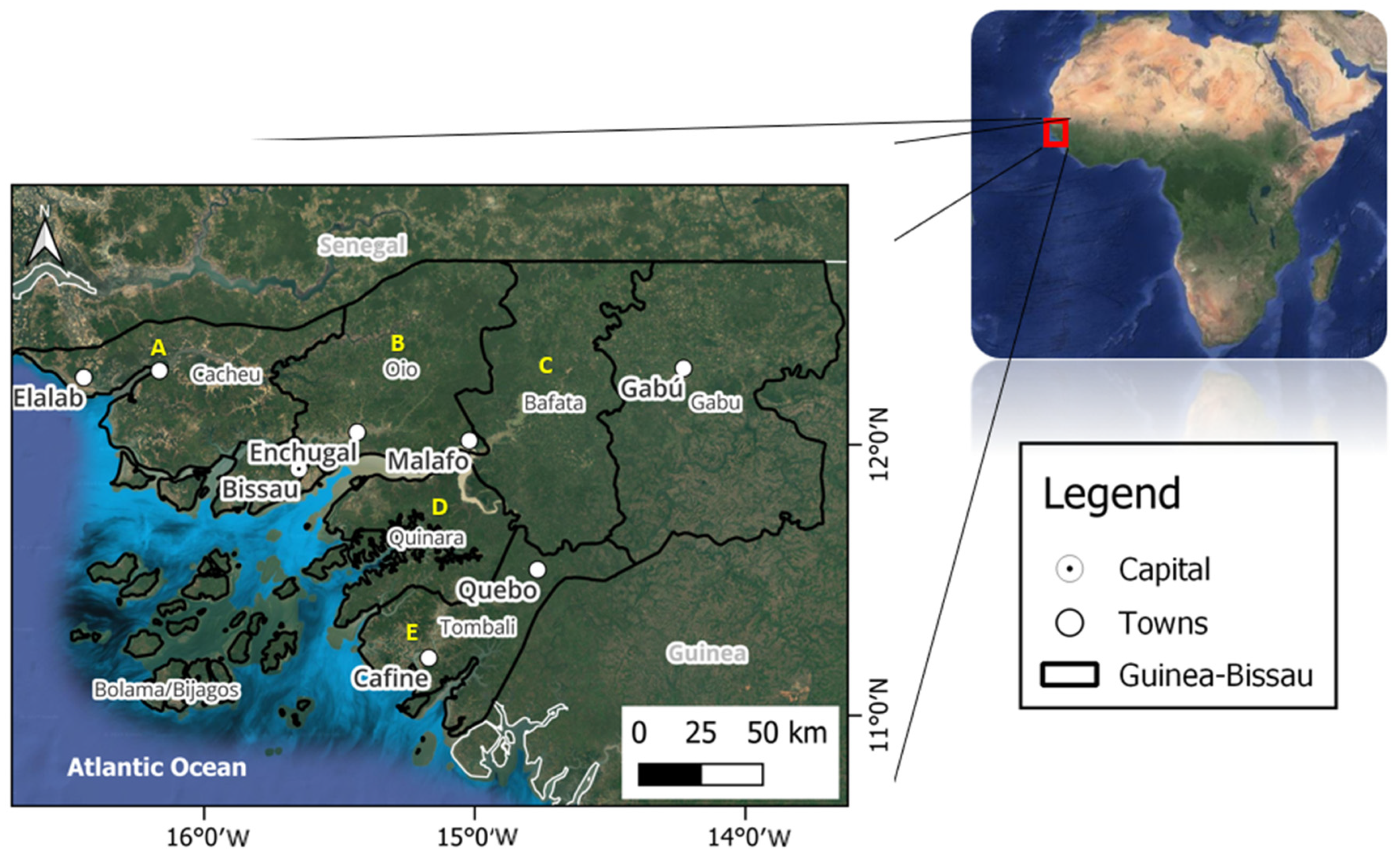
Figure 1. Location of Guinea-Bissau and main regions (Cacheu = A, Oio = B, Bafata = C, Quinara = D, Tombali = E) where swamp rice is cropped.
Agronomy 14 00468 g001
Figure 2. Rice production systems (RPSs) of Guinea-Bissau.
Agronomy 14 00468 g002
Figure 3. Some characteristics of the “bolanhas” of the mangrove swamp rice system (MSRPS) of Guinea-Bissau.
Agronomy 14 00468 g003
Figure 4. Plots of mangrove swamp rice production system in mangrove of Elalab, Guinea Bissau. (A) Village (Tabanca), (B) fish production plot in the Felupe/Baiote system (Orike de pisca), (C) Associated mangrove (bolanha doce), (D) Tidal mangrove (bolanha salgada), (E) New mangrove plots (bolanha novo), (F) Mangroves (tarrafe).
Agronomy 14 00468 g004
Figure 5. Smoothed conditional means plots of the harvested area (ha) and national production (Mg) of rice from 1961 to 2022 [69].
Agronomy 14 00468 g005
Figure 6. Salinity classes according to electrical conductivity (EC) in water suspension (1:5) for final dry conditions (before the beginning of the rainfall season) based on the salinity tolerance of rice. Downward arrow illustrates decrease in class as a result of rainfall, salt dilution, or leaching. (Adapted from [61]).
Agronomy 14 00468 g006
Figure 7. Characteristic of southern Balanta (A), northern Felupe and Baiote (B), and an example of new bolanhas (C) in Guinea-Bissau. 1 = Main dike in the south (Orike grande); 2 = verandah (Varanda); 3 = main drainage (Valeta); 4 = plot bunds (Orike pekno); 5 = small drainage without outlets in the south (Valeta do prike); 6 = main dike without verandah in the north (Orike grande); 7 = plot without internal drainage in the north (Prike); 8 = ridges (Réguas); 9 = new plot without ridges (Bolanha novo). Adapted from [28,58,79].
Agronomy 14 00468 g007
Figure 8. Chemical process in acid sulfate soils within mangrove swamp rice production systems. Adapted from [40,111].
Agronomy 14 00468 g008
Figure 9. Smoothed conditional means plots of rainfall (mm) in Bolama, Bafata, and Bissau, Guinea-Bissau, for the period 1961–2022. Data source: World Bank information [70] and National Institute of Meteorology of Guinea Bissau.
Agronomy 14 00468 g009
Figure 10. Plots of a rice production system in mangrove, Elalab, Guinea-Bissau. Identification of (a) dikes, (b) drainage channels, (c) plots, (d) bunds, and (e) ridges.
Agronomy 14 00468 g010
Table 1. Rice yields in upland and mangrove swamp system (MSRPS) reported in the literature.
Year/SystemYield Ranges (kg ha−1)References
UplandMSRPS
1947-2060–3000[75]
1948-1620–2680[75]
1949-1040–1960[75]
1953300–6001800–2000[54]
196810981832[54]
1970600–8001000–3000[19]
1982-1900[76]
1983-2700[76]
1986270–9501020–3750[77]
1987-1305–2700[78]
1988-1714–3033[78]
1990400–600-[79]
1991300–600600–1500[18]
1994-1960[76]
1995-2800[80]
19995001500–4000[79]
200110003000[12]
2008400–800-[20]
2008400–800-[20]
2010-1584[72]
2014-1700–2600[31]
2015-1120–2870[81]
2017-1000[12]
2021-1600[30]
2023-1180–1910[39]
Table 2. Characteristics of Oryza glaberrima and Oryza sativa reportedly used for rice production systems in mangroves in West Africa.
Species History and Adaptability Phenotypic Characteristics Genotypic Characteristics
Oryza glaberrima
  • Indigenous African rice
  • Wild ancestor O. Brevilugata
  • Domesticated 2000–3000 years ago
  • Dryland and wetland rice cultivation
  • High adaptability in water depth fluctuations
  • Some varieties have high salinity tolerance
  • Some varieties have high draught tolerance
  • Small grain
  • Dark seed color
  • Pear-shaped grains
  • Grain with red, olive to black seedcoat
  • Straight panicles
  • Panicles with simple branches
  • Short rounded ligules
  • Wide leaves
  • Seed scatters easily
  • The grain is brittle
  • Difficult to mill
  • Short and medium cycle
  • Tolerance to diseases and pests
  • Tolerance to iron toxicity
  • Tolerance to acidity
  • Tolerance to low fertility soils
  • Salt or drought tolerance
  • Good acclimatization
Oryza sativa
  • Asiatic origins
  • Two strains (O. japonica, O. indica)
  • Introduced early 1600s by Portuguese and/or Arabs
  • Dryland and wetland rice cultivation
  • Lower tolerance of fluctuations in water depth
  • Competes slowly with weeds
  • Some varieties have high or low salinity tolerance
  • Bigger grains
  • General white seed color
  • Pear-shaped grains
  • Panicles are not upright
  • Pointed ligules
  • Panicles bend after flowering and have more ramifications
  • Short, medium, and long cycles
  • More susceptible to diseases and pests
  • Less seeds are scattered on the ground
References[16,19,21,57,79,80]
Table 4. Soil taxonomy and physicochemical characteristics in mangrove terraces, tidal mangrove, and associated mangrove fields in Guinea-Bissau.
CharacteristicsTidal Mangrove TerraceTidal Mangrove FieldsAssociated Mangrove Fields
Soil taxonomy
(USDA)
Haplic sulfaquents, typic sulfaquents, sulfic fluvaquents, sulfic, hydraquents, sulfohimists, hemists, fibrists.Histic sulfaquents, hapic sulfaquents, yypic sulfaquepts, sulfic hydraqiuents, tropofibrits,
psammaquents, sulfic tropaquepts, typic tropaquepts, aeric tropaquepts, psammaquents.
Pisoplinthic, hypothionic, tidalic, oxygleyic, tropoquepts, endoaquents.
Soil taxonomy
(WRB-FAO)
Tidalic, oxygleyic,
gleysol (clayic, hyposulfidic).
Hypothionic,
pisoplintic, oxygleyic, tidalic, gleysol (vertic, drainic, salic, clayic).
Pisoplintic, hypothionic, gleysol (abruptic, loamy, drainic, salic, clayic, vertic).
Geochemical conditionsAnoxic Sub-oxidation Oxidation
Solubility of sulfates and sulfitesHigh High–medium Low
Al-Fe2+ toxicityHighHigh–mediumMedium–low
Na+HighHighMedium–low
Soil organic carbonHigh High–medium Low
Possible chemical formationsReduced iron (Fe2+)
Iron monosulfide (FeS)
Iron disulfide (FeS2)
Iron monosulfide (FeS)
Pyrite (2FeS2)
Reduced iron (Fe2+)
Oxidized iron (Fe3+)
Hydrogen (H+)
Hydrogen sulfite (H2S)
Aluminum (Al2+)
Sulfate (SO42−)
Sulfites (SO32−)
Pyrite (2FeS2)
Hydrogen (H+)
Aluminum (Al3+)
Oxidized iron (Fe3+)
Sodium (Na+)
Sulfate (SO42−)
References[59,63,111,117]
Disclaimer/Publisher’s Note: The statements, opinions and data contained in all publications are solely those of the individual author(s) and contributor(s) and not of MDPI and/or the editor(s). MDPI and/or the editor(s) disclaim responsibility for any injury to people or property resulting from any ideas, methods, instructions or products referred to in the content.