Evolutionary Trend Analysis of Agricultural Non-Point Source Pollution Load in Chongqing Based on Land Use Simulation
Abstract
1. Introduction
2. Materials and Methods
2.1. Study Area
2.2. Data Sources
2.3. Methods
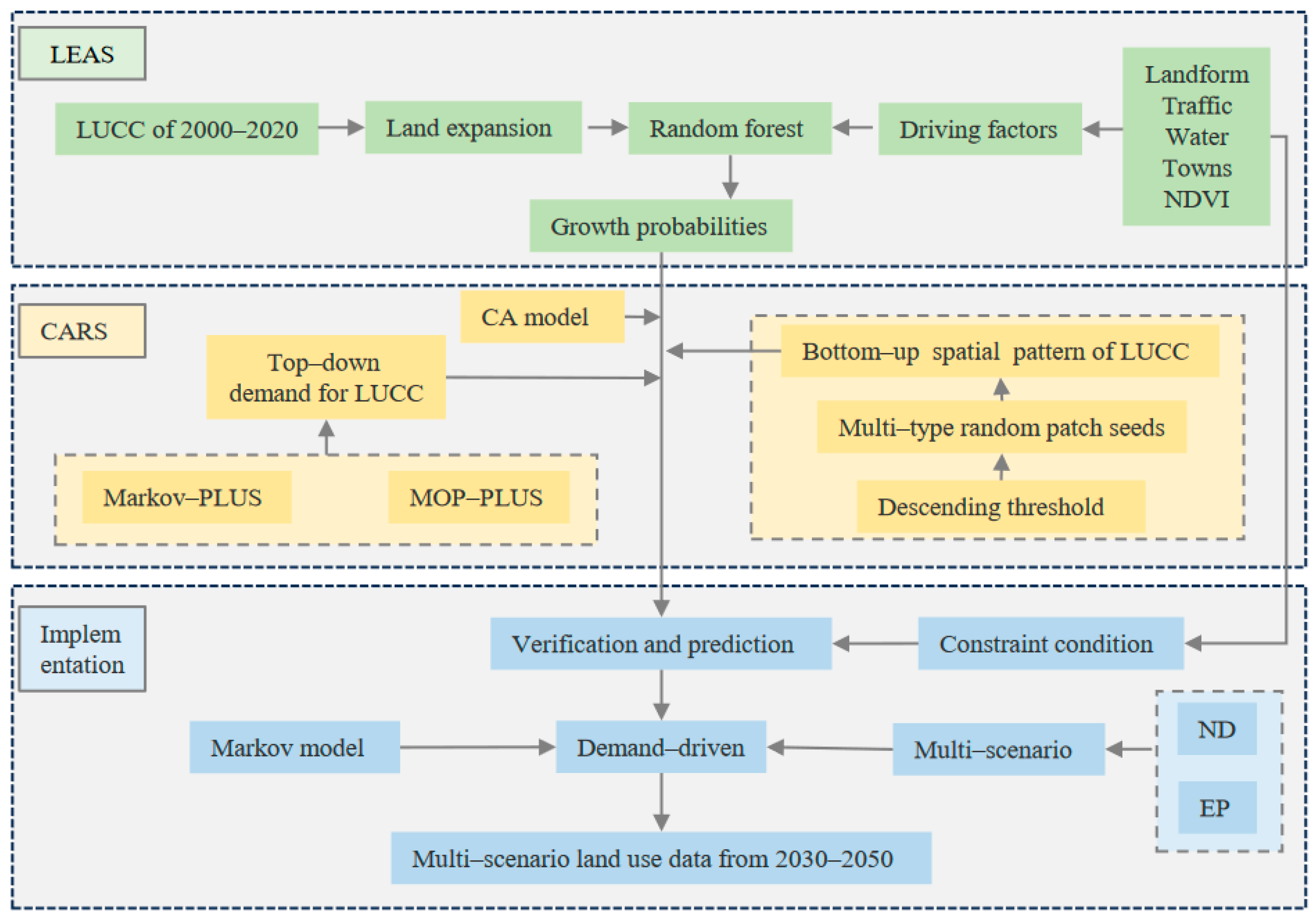
2.3.1. The PLUS Model
- (1)
- LEAS module.
- (2)
- CARS module.
2.3.2. The Export Coefficient Model
3. Results
3.1. Land Use Status and Simulation Accuracy Analysis
3.2. Land Use Data Simulation under Future Development Scenarios
3.3. Measuring ANPSP Load in Long-Term Series
3.3.1. Analysis of Changes in ANPSP Load from 2000 to 2020
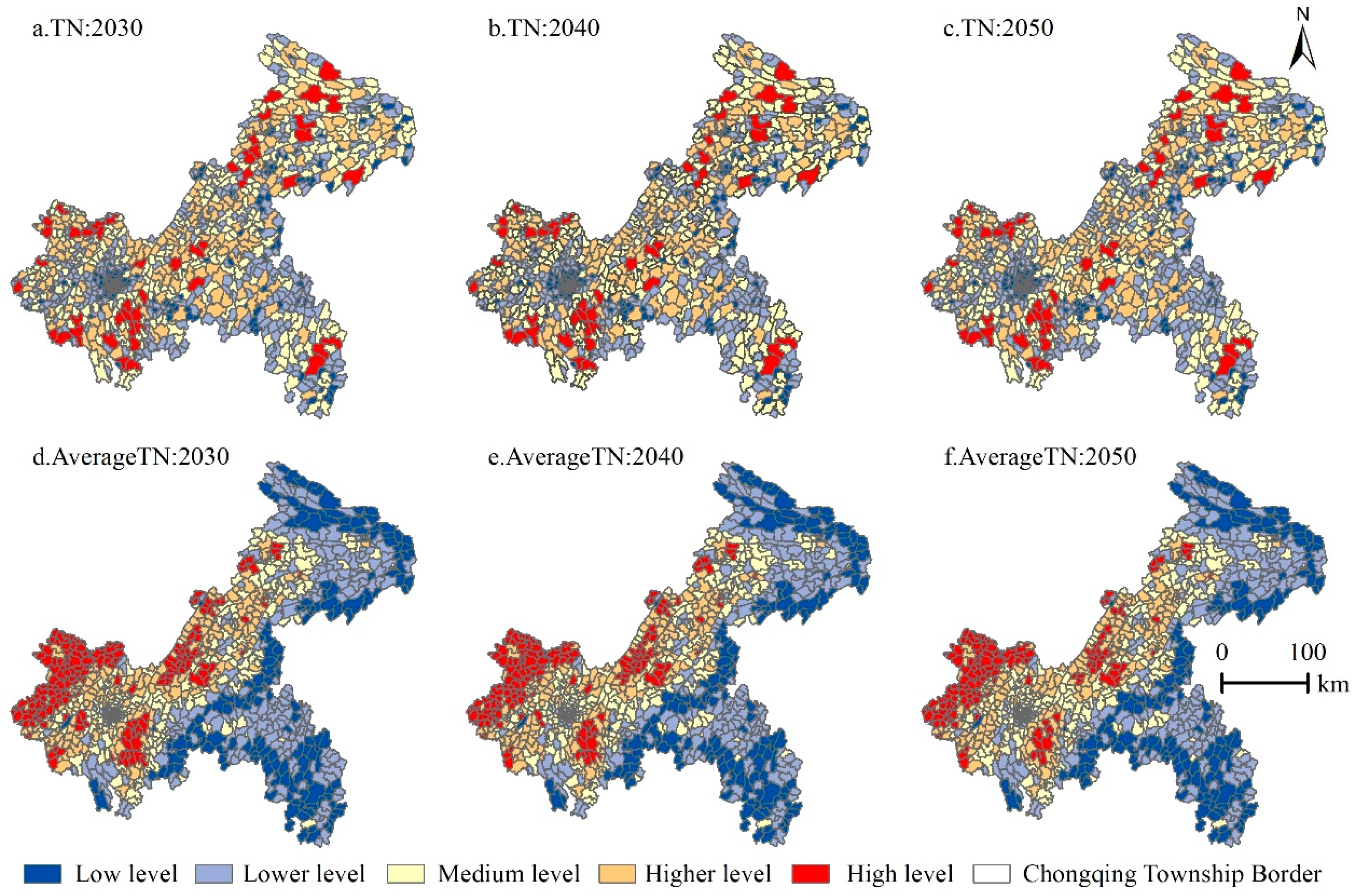
3.3.2. Analysis of the Change in ANPSP Load under the ND in 2030–2050
3.3.3. Analysis of the Change in ANPSP Load under the EP in 2030–2050
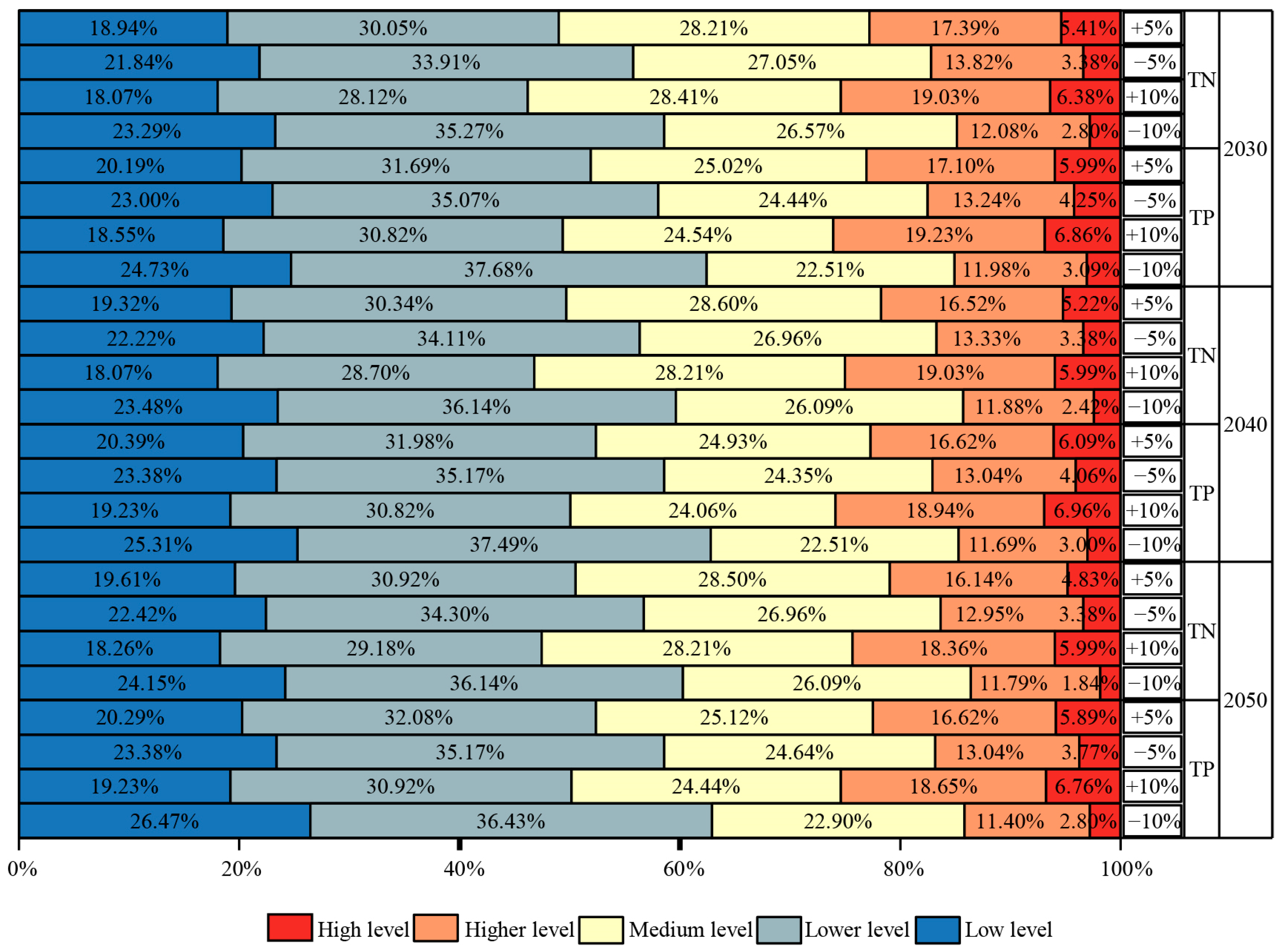
3.4. Sensitivity Analysis of Output Coefficients to Pollutant Load Levels
4. Discussion
4.1. The PLUS Model Is Suitable for Simulating Land Use-Type Data in Chongqing City
4.2. Sensitivity Analysis Can Better Identify Key Areas for Pollution Control
4.3. Land Use Pattern Optimization Plays an Important Role in the Prevention and Control of ANPSP
4.4. Limitations and Future Prospects of this Study
5. Conclusions
- (1)
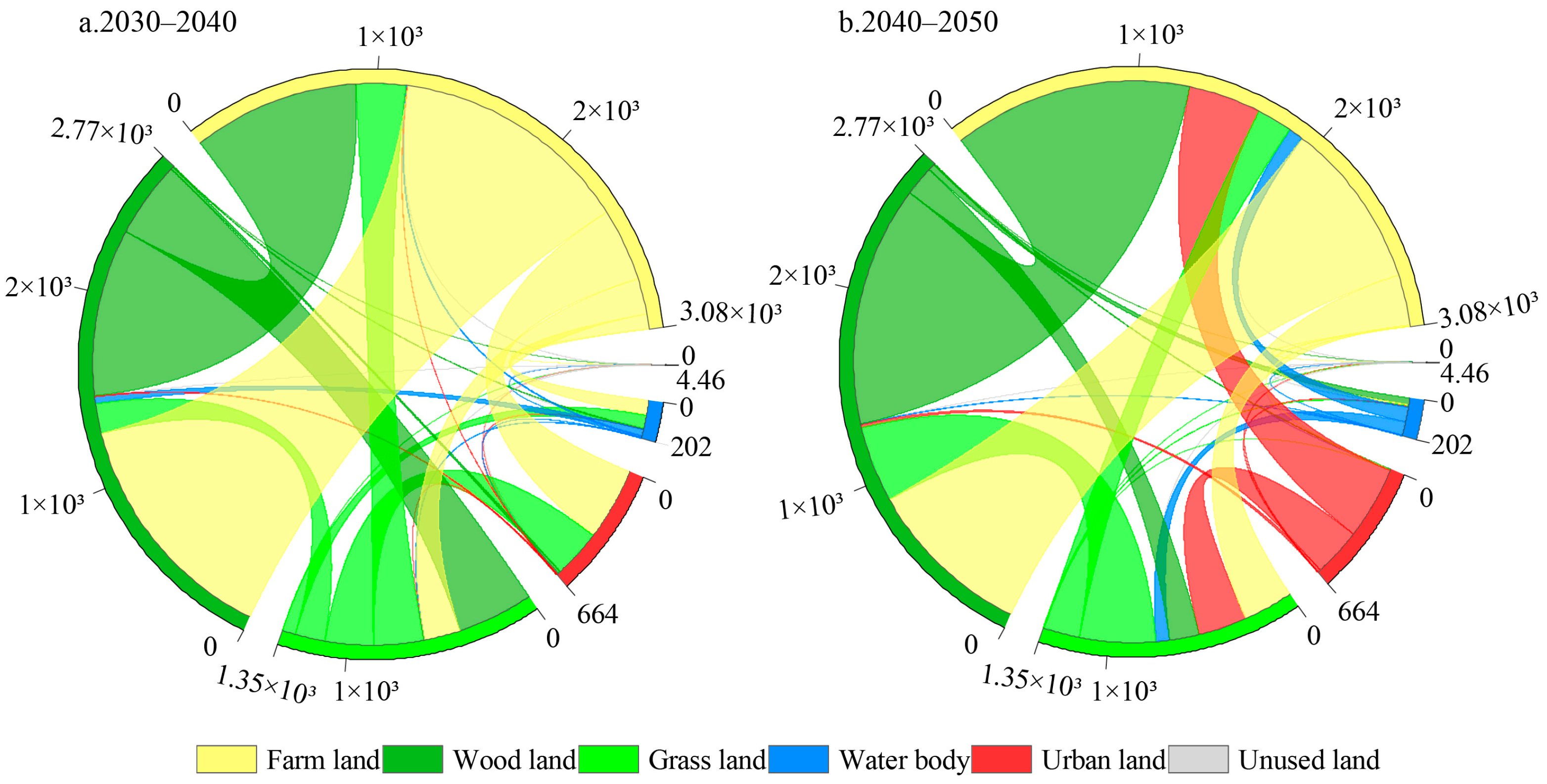
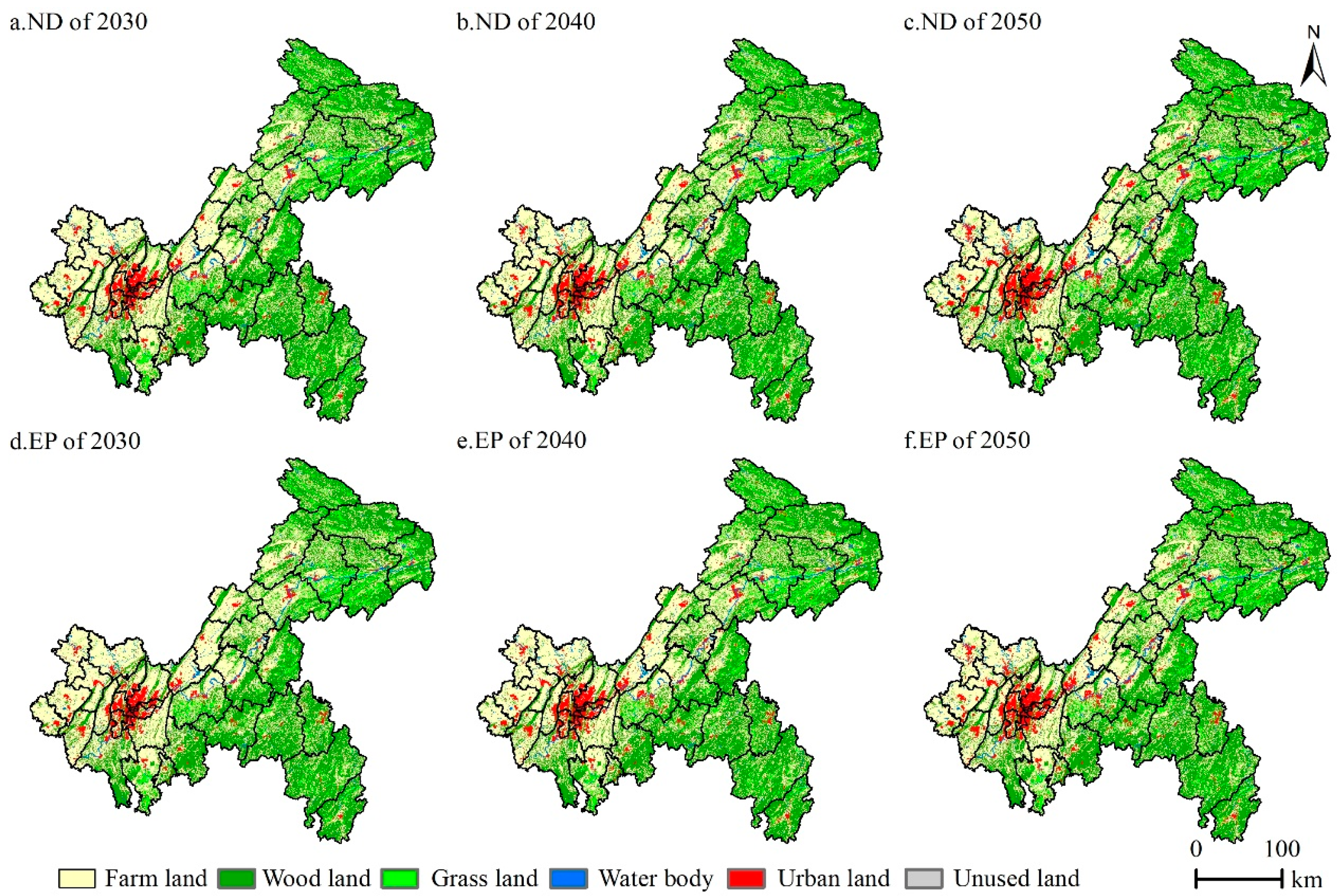
- The PLUS model has high accuracy in simulating the spatial distribution of future land in Chongqing. Wood land and farm land are the primary land use types in Chongqing. In the ND, the urban land area will increase from 3.98% in 2030 to 6.20% in 2050. In the EP, the urban land area will increase from 3.87% in 2030 to 5.87% in 2050. The urban expansion will further occupy cropland.
- (2)
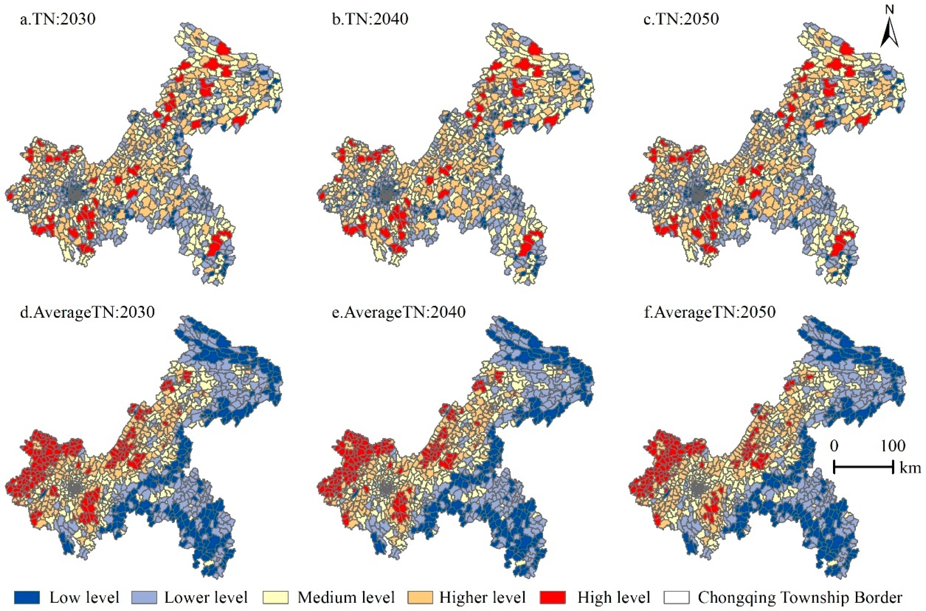
- From 2000 to 2020, the proportion of high-level zones with TN pollution load levels in Chongqing was 4.93%, 5.02%, and 4.73%, respectively. In both scenarios, the number of high-level zones decreased, and the average load level decreased from west to east.
- (3)
- The sensitivity analysis found that the number of townships with increased levels when TN and TP output coefficients were increased was greater than the number of townships with decreased levels when the output coefficients were decreased. This indicates that the risk level is more sensitive to the increase in fertilizer application. Sensitivity analysis can better identify critical areas for pollution control, and the areas sensitive to changes in farmers’ behavior mainly include Hechuan District, Nanchuan District, Qijiang District, Jiangjin District, and Bishan District.
Author Contributions
Funding
Data Availability Statement
Conflicts of Interest
References
- Falconer, L.; Telfer, T.C.; Ross, L.G. Modelling seasonal nutrient inputs from non-point sources across large catchments of importance to aquaculture. Aquaculture 2018, 495, 682–692. [Google Scholar] [CrossRef]
- Chen, T.; Lu, J.Y.; Lu, T.; Yang, X.D.; Zhong, Z.; Feng, H.J.; Wang, M.Z.; Yin, J. Agricultural non-point source pollution and rural transformation in a plain river network: Insights from Jiaxing city, China. Environ. Pollut. 2023, 333, 121953. [Google Scholar] [CrossRef] [PubMed]
- Zhao, H.; Wang, Y.; Dong, Y.K.; He, Z.L.; Wang, P.; Zheng, H.G.; He, J.F.; Zeng, W.J. Modeling the response of agricultural non-point source pollution to planting structure and fertilization level in Erhai Lake Basin under low-latitude plateau climate. Ecol. Indic. 2023, 154, 110829. [Google Scholar] [CrossRef]
- Volk, M.; Liersch, S.; Schmidt, G. Towards the implementation of the European Water Framework Directive?: Lessons learned from water quality simulations in an agricultural watershed. Land Use Policy 2009, 26, 580–588. [Google Scholar] [CrossRef]
- Kumar, L.; Kumari, R.; Kumar, A.; Tunio, I.A.; Sassanelli, C. Water Quality Assessment and Monitoring in Pakistan: A Comprehensive Review. Sustainability 2023, 15, 6246. [Google Scholar] [CrossRef]
- Ahn, S.-R.; Kim, S.-J. The Effect of Rice Straw Mulching and No-Tillage Practice in Upland Crop Areas on Nonpoint-Source Pollution Loads Based on HSPF. Water 2016, 8, 106. [Google Scholar] [CrossRef]
- Zeng, F.F.; Zuo, Z.; Mo, J.C.; Chen, C.Y.; Yang, X.J.; Wang, J.J.; Wang, Y.; Zhao, Z.Q.; Chen, T.Y.; Li, Y.T.; et al. Runoff Losses in Nitrogen and Phosphorus From Paddy and Maize Cropping Systems: A Field Study in Dongjiang Basin, South China. Front. Plant Sci. 2021, 12, 675121. [Google Scholar] [CrossRef] [PubMed]
- Wang, M.M.; Jiang, T.H.; Mao, Y.B.; Wang, F.J.; Yu, J.; Zhu, C. Current Situation of Agricultural Non-Point Source Pollution and Its Control. Water Air Soil Pollut. 2023, 234, 471. [Google Scholar] [CrossRef]
- Chuan, L.M.; Zheng, H.G.; Wang, A.L.; Zhao, J.J.; Yan, Z.H. The situation and research progress of agricultural non-point source pollution in China. IOP Conf. Ser. Earth Environ. Sci. 2020, 526, 012015. [Google Scholar] [CrossRef]
- Zhou, L.L.; Geng, R.Z. Development and Assessment of a New Framework for Agricultural Nonpoint Source Pollution Control. Water 2021, 13, 3156. [Google Scholar] [CrossRef]
- Yu, W.Q.; Zhang, J.; Liu, L.J.; Li, Y.; Li, X.Y. A source-sink landscape approach to mitigation of agricultural non-point source pollution: Validation and application. Environ. Pollut. 2022, 314, 120287. [Google Scholar] [CrossRef] [PubMed]
- Park, M.; Choi, Y.S.; Shin, H.J.; Song, I.; Yoon, C.G.; Choi, J.D.; Yu, S.J. A Comparison Study of Runoff Characteristics of Non-Point Source Pollution from Three Watersheds in South Korea. Water 2019, 11, 966. [Google Scholar] [CrossRef]
- Zhang, X.Q.; Chen, P.; Dai, S.N.; Han, Y. Analysis of non-point source nitrogen pollution in watersheds based on SWAT model. Ecol. Indic. 2022, 138, 108881. [Google Scholar] [CrossRef]
- Wang, H.; Liu, C.; Xiong, L.C.; Wang, F.T. The spatial spillover effect and impact paths of agricultural industry agglomeration on agricultural non-point source pollution: A case study in Yangtze River Delta, China. J. Clean. Prod. 2023, 401, 136600. [Google Scholar] [CrossRef]
- Li, N.; Han, W.Z.; Shen, M.N.; Yu, S.L. Load evaluation of non-point source pollutants from reservoir based on export coefficient modeling. Nongye Gongcheng Xuebao/Trans. Chin. Soc. Agric. Eng. 2016, 32, 224–230. [Google Scholar] [CrossRef]
- Johnes, P.J. Evaluation and management of the impact of land use change on the nitrogen and phosphorus load delivered to surface waters: The export coefficient modelling approach. J. Hydrol. Amst. 1996, 183, 323–349. [Google Scholar] [CrossRef]
- Worrall, F.; Burt, T.P.; Howden, N.J.K.; Whelan, M.J. The fluvial flux of nitrate from the UK terrestrial biosphere—An estimate of national-scale in-stream nitrate loss using an export coefficient model. J. Hydrol. 2012, 414–415, 31–39. [Google Scholar] [CrossRef]
- Zhang, L.; Endreny, T.A.; Stephan, E.A. Stochastic export coefficient model to predict annual variation in phosphorus loading from diffuse runoff. J. Hydrol. 2023, 620, 129447. [Google Scholar] [CrossRef]
- Zhu, K.W.; Chen, Y.C.; Xiong, H.L.; Zhang, S.; Yang, Z.M.; Huang, L.; Lei, B. Impact analysis ofthe future development scenario on risks from agricultural non-point source pollution. J. Agro-Environ. Sci. 2021, 40, 1971–1981. [Google Scholar]
- Babbar, D.; Areendran, G.; Sahana, M.; Sarma, K.; Raj, K.; Sivadas, A. Assessment and prediction of carbon sequestration using Markov chain and InVEST model in Sariska Tiger Reserve, India. J. Clean. Prod. 2021, 278, 123333. [Google Scholar] [CrossRef]
- Islam, S.; Li, Y.C.; Ma, M.G.; Chen, A.X.; Ge, Z.X. Simulation and Prediction of the Spatial Dynamics of Land Use Changes Modelling Through CLUE-S in the Southeastern Region of Bangladesh. J. Indian Soc. Remote Sens. 2021, 49, 2755–2777. [Google Scholar] [CrossRef]
- Liang, X.; Guan, Q.F.; Clarke, K.C.; Liu, S.S.; Wang, B.Y.; Yao, Y. Understanding the drivers of sustainable land expansion using a patch-generating land use simulation (PLUS) model: A case study in Wuhan, China. Comput. Environ. Urban Syst. 2021, 85, 101569. [Google Scholar] [CrossRef]
- Blissag, B.; Yebdri, D.; Kessar, C. Spatiotemporal change analysis of LULC using remote sensing and CA-ANN approach in the Hodna basin, NE of Algeria. Phys. Chem. Earth 2024, 133, 103535. [Google Scholar] [CrossRef]
- Chasia, S.; Olang, L.O.; Sitoki, L. Modelling of land-use/cover change trajectories in a transboundary catchment of the Sio-Malaba-Malakisi Region in East Africa using the CLUE-s model. Ecol. Model. 2023, 476, 110256. [Google Scholar] [CrossRef]
- Zhu, K.W.; Yang, Z.M.; Huang, L.; Chen, Y.C.; Zhang, S.; Xiong, H.L.; Wu, S.; Lei, B. Coupling ITO3dE model and GIS for spatiotemporal evolution analysis of agricultural non-point source pollution risks in Chongqing in China. Sci. Rep. 2021, 11, 4635. [Google Scholar] [CrossRef]
- Xiao, X.C.; Ni, J.P.; He, B.H.; Xie, D.T. Estimation of Agricultural Nonpoint Source Pollution Loads and Its Regional Differentiation in Chong. J. Basic Sci. Eng. 2014, 22, 634–646. [Google Scholar]
- Guan, X.Y.; Tao, Y.; Chen, H.R.; Chang, X.M. Assessing risk and governing of agricultural non-point source pollution in Three Gorges Reservoir Areas. Trans. CSAE 2023, 39, 200–210. [Google Scholar]
- Li, X.; Fu, J.Y.; Jiang, D.; Lin, G.; Cao, C.L. Land use optimization in Ningbo City with a coupled GA and PLUS model. J. Clean. Prod. 2022, 375, 134004. [Google Scholar] [CrossRef]
- Han, P.; Xiang, J.W.; Zhao, Q.L. Spatial differentiation and scenario simulation of cultivated land in mountainous areas of Western Hubei, China: A PLUS model. Environ. Sci. Pollut. Res. Int. 2023, 30, 52804–52817. [Google Scholar] [CrossRef]
- Lin, X.; Wang, Z.T. Landscape ecological risk assessment and its driving factors of multi-mountainous city. Ecol. Indic. 2023, 146, 109823. [Google Scholar] [CrossRef]
- Xiang, S.J.; Wang, Y.; Deng, H.; Yang, C.M.; Wang, Z.F.; Gao, M. Response and multi-scenario prediction of carbon storage to land use/cover change in the main urban area of Chongqing, China. Ecol. Indic. 2022, 142, 109205. [Google Scholar] [CrossRef]
- Norvell, W.A.; Frink, C.R.; Hill, D.E. Phosphorus in Connecticut lakes predicted by land use. Proc. Natl. Acad. Sci. USA 1979, 76, 5426–5429. [Google Scholar] [CrossRef]
- Zhu, K.W.; Song, D.; Chen, Y.C.; Huang, C.Q.; Duan, Q.Y.; Zhang, S. Evolution Analysis of Non-point Source Pollution Risk in Chongqing Based on Improved Output Coefficient Model. Environ. Impact Assess. 2022, 44, 79–83. [Google Scholar]
- Lu, C.; Qi, X.; Zheng, Z.S.; Jia, K. PLUS-Model Based Multi-Scenario Land Space Simulation of the Lower Yellow River Region and Its Ecological Effects. Sustainability 2022, 14, 6942. [Google Scholar] [CrossRef]
- Cao, X.F.; Liu, Z.S.; Li, S.J.; Gao, Z.J. Integrating the Ecological Security Pattern and the PLUS Model to Assess the Effects of Regional Ecological Restoration: A Case Study of Hefei City, Anhui Province. Int. J. Environ. Res Public Health 2022, 19, 6640. [Google Scholar] [CrossRef] [PubMed]
- Li, Y.H.; Yao, S.; Jiang, H.Z.; Wang, H.R.; Ran, Q.C.; Gao, X.Y.; Ding, X.Y.; Ge, D.D. Spatial-Temporal Evolution and Prediction of Carbon Storage: An Integrated Framework Based on the MOP–PLUS–InVEST Model and an Applied Case Study in Hangzhou, East China. Land 2022, 11, 2213. [Google Scholar] [CrossRef]
- Huang, J.J.; Lin, X.J.; Wang, J.H.; Wang, H. The precipitation driven correlation based mapping method (PCM) for identifying the critical source areas of non-point source pollution. J. Hydrol. 2015, 524, 100–110. [Google Scholar] [CrossRef]
- Zuo, D.P.; Han, Y.A.; Gao, X.X.; Ma, G.W.; Xu, Z.X.; Bi, Y.Q.; Abbaspour, K.C.; Yang, H. Identification of priority management areas for non-point source pollution based on critical source areas in an agricultural watershed of Northeast China. Environ. Res. 2022, 214, 113892. [Google Scholar] [CrossRef] [PubMed]
- Ding, Y.; Dong, F.; Zhao, J.Y.; Peng, W.Q.; Chen, Q.C.; Ma, B. Non-Point Source Pollution Simulation and Best Management Practices Analysis Based on Control Units in Northern China. Int. J. Environ. Res. Public Health 2020, 17, 868. [Google Scholar] [CrossRef]
- Chang, D.; Lai, Z.Q.; Li, S.; Li, D.; Zhou, J. Critical source areas’ identification for non-point source pollution related to nitrogen and phosphorus in an agricultural watershed based on SWAT model. Environ. Sci. Pollut. Res. Int 2021, 28, 47162–47181. [Google Scholar] [CrossRef]
- Xu, W.; Liu, L.; Zhu, S.J.; Sun, A.H.; Ding, Z.Y.; Wang, H. Identifying the critical areas and primary sources for agricultural nonpoint source pollution management of an emigrant town within the Three Gorges reservoir area. Environ. Monit. Assess. 2023, 195, 602. [Google Scholar] [CrossRef] [PubMed]
- Zhu, K.W.; Chen, Y.C.; Zhang, S.; Yang, Z.M.; Huang, L.; Li, L.; Lei, B.; Zhou, Z.B.; Xiong, H.L.; Li, X.X.; et al. Output risk evolution analysis of agricultural non-point source pollution under different scenarios based on multi-model. Glob. Ecol. Conserv. 2020, 23, e01144. [Google Scholar] [CrossRef]



| Types | Driving Factors | Meaning |
|---|---|---|
| Terrain data | Elevation | DEM data |
| Traffic data | Distance from highway | The distance from roads and water systems is expressed in Euclidean distance |
| Distance from expressway | ||
| Distance from ordinary highways | ||
| Stream | Distance from other roads | |
| Distance from primary rivers | ||
| Distance from secondary rivers | ||
| Urban data | Urban land | / |
| Vegetation Index | NDVI data | / |
| Regions restricted by national regulations for development | Water area | / |
| Pollution Type | Farm Land | Wood Land | Grass Land | Urban Land | Water Body | Unused Land |
|---|---|---|---|---|---|---|
| TN | 24.19 | 2.60 | 6.04 | 13.00 | - | - |
| TP | 1.86 | 0.17 | 0.85 | 1.80 | - | - |
| Pollution Load Level | Number of Townships (TN) | Number of Townships (TP) | ||||
|---|---|---|---|---|---|---|
| 2030 | 2040 | 2050 | 2030 | 2040 | 2050 | |
| Low-level zone | 211 | 215 | 216 | 229 | 230 | 229 |
| Lower-level zone | 330 | 333 | 338 | 339 | 339 | 346 |
| Medium-level zone | 290 | 292 | 288 | 265 | 226 | 264 |
| Higher-level zone | 157 | 150 | 148 | 147 | 147 | 147 |
| High-level zone | 47 | 45 | 45 | 55 | 53 | 49 |
| Pollution Load Level | Number of Townships (TN) | Number of Townships (TP) | ||||
|---|---|---|---|---|---|---|
| 2030 | 2040 | 2050 | 2030 | 2040 | 2050 | |
| Low-level zone | 210 | 215 | 216 | 229 | 230 | 229 |
| Lower-level zone | 331 | 330 | 339 | 341 | 340 | 345 |
| Medium-level zone | 290 | 295 | 287 | 264 | 264 | 264 |
| Higher-level zone | 157 | 150 | 148 | 146 | 148 | 147 |
| High-level zone | 47 | 45 | 45 | 55 | 53 | 50 |
| Chongqing Metropolitan Area | Northeast Chongqing Urban Agglomeration | Southeast Chongqing Urban Agglomeration | |
|---|---|---|---|
| +5% | Hechuan, Jiangjin, Bishan, and Rongchang | Zhongxian, Liangping, Yunyang, and Fengjie | Wulong and Pengshui |
| +10% | Hechuan, Nanchuan, Qijiang, Jiangjin, Bishan, Rongchang, and Changshou | Zhongxian, Liangping, Wanzhou, Yunyang, Fengjie, and Wushan | Wulong, Pengshui, and Xiushan |
| −5% | Dazu and Nanchuan | Fengdu and Kaizhou | Youyang |
| −10% | Tongliang, Qijiang, Nanuan, Banan, Fuling, Dazu, and Yubei | Fengdu, Dianjiang, Kaizhou, Wanzhou, Fengjie, and Wuxi | Shizhu, Pengshui, and Youyang |
| Author | Model | Study Area | Kappa |
|---|---|---|---|
| Lu et al. [34] | PLUS | The yellow river | 0.812 |
| Cao et al. [35] | PLUS | Hefei | 0.85 |
| Han et al. [29] | PLUS | Enshi City and Lichuan City | 0.81 |
| Li et al. [36] | PLUS | Hangzhou City | 0.75 |
| 20% | 40% | 60% | 80% | |||||||
|---|---|---|---|---|---|---|---|---|---|---|
| Township | Total Pollution Level | Township | Total Pollution Level | Township | Total Pollution Level | Township | Total Pollution Level | |||
| 2020 | Farm land | 83.86 | 93.00 | 52.27 | 64.25 | 31.69 | 42.31 | 15.17 | 21.17 | |
| Wood land | 62.80 | 63.54 | 38.55 | 36.24 | 18.55 | 15.37 | 2.71 | 1.55 | ||
| 2050 | NP | Farm land | 81.06 | 91.67 | 46.86 | 59.52 | 27.54 | 37.35 | 10.92 | 15.73 |
| Wood land | 64.15 | 66.16 | 39.13 | 38.34 | 19.13 | 16.72 | 2.61 | 1.48 | ||
| EP | Farm land | 80.87 | 91.61 | 45.99 | 58.63 | 27.05 | 36.45 | 10.72 | 15.38 | |
| Wood land | 64.25 | 66.13 | 39.13 | 38.21 | 19.13 | 16.64 | 2.71 | 1.44 | ||
Disclaimer/Publisher’s Note: The statements, opinions and data contained in all publications are solely those of the individual author(s) and contributor(s) and not of MDPI and/or the editor(s). MDPI and/or the editor(s) disclaim responsibility for any injury to people or property resulting from any ideas, methods, instructions or products referred to in the content. |
© 2024 by the authors. Licensee MDPI, Basel, Switzerland. This article is an open access article distributed under the terms and conditions of the Creative Commons Attribution (CC BY) license (https://creativecommons.org/licenses/by/4.0/).
Share and Cite
Zhu, K.; Zhang, Y.; Tian, X.; Guan, D.; Zhang, S.; He, Y.; Zhou, L. Evolutionary Trend Analysis of Agricultural Non-Point Source Pollution Load in Chongqing Based on Land Use Simulation. Agronomy 2024, 14, 737. https://doi.org/10.3390/agronomy14040737
Zhu K, Zhang Y, Tian X, Guan D, Zhang S, He Y, Zhou L. Evolutionary Trend Analysis of Agricultural Non-Point Source Pollution Load in Chongqing Based on Land Use Simulation. Agronomy. 2024; 14(4):737. https://doi.org/10.3390/agronomy14040737
Chicago/Turabian StyleZhu, Kangwen, Yan Zhang, Xiaosong Tian, Dongjie Guan, Sheng Zhang, Yong He, and Lilei Zhou. 2024. "Evolutionary Trend Analysis of Agricultural Non-Point Source Pollution Load in Chongqing Based on Land Use Simulation" Agronomy 14, no. 4: 737. https://doi.org/10.3390/agronomy14040737
APA StyleZhu, K., Zhang, Y., Tian, X., Guan, D., Zhang, S., He, Y., & Zhou, L. (2024). Evolutionary Trend Analysis of Agricultural Non-Point Source Pollution Load in Chongqing Based on Land Use Simulation. Agronomy, 14(4), 737. https://doi.org/10.3390/agronomy14040737


