Article

Changes in Soil Organic Matter Associated with Land Use of Arenosols from Southern Botswana

by
Donald Kgathi
1,
Mogodisheng Sekhwela
2 and
Gonzalo Almendros
3,4,*
1
Okavango Research Institute, University of Botswana, Gaborone Private Bag BO 285, Botswana
2
Office of Research and Development, Botswana Open University, Gaborone Private Bag BO 187, Botswana
3
National Museum of Natural Sciences (CSIC), Serrano 115 B, 28006 Madrid, Spain
4
Department of Geology and Geochemistry, Faculty of Science, Universidad Autónoma de Madrid (UAM), 28049 Madrid, Spain
*
Author to whom correspondence should be addressed.
Agronomy 2024, 14(8), 1869; https://doi.org/10.3390/agronomy14081869
Submission received: 10 July 2024 / Revised: 13 August 2024 / Accepted: 19 August 2024 / Published: 22 August 2024
(This article belongs to the Section Soil and Plant Nutrition)

Abstract

:
The effect of land use on sandy soils of southern Botswana was carried out by comparing the composition and properties of soil organic matter. Non-disturbed and disturbed soils were sampled from savanna ecosystems (Central District and Kweneng District). The biodegradability of organic matter was evaluated by incubation in the laboratory. Humic fractions were quantified and humic acids were analyzed by visible and infrared spectroscopy. The results indicate that continued disturbance, whether due to grazing or subsistence farming, has resulted in small yet significant changes in the concentration of available nutrients and organic matter in the soil. Nevertheless, substantial changes could be established in the soil C/N ratio, in the humic acid/fulvic acid ratio, and in the biodegradability of soil organic matter and the structural characteristics of humic acids. The increased aromaticity of humic acid (visible and IR spectroscopies) following disturbance suggests increased biogeochemical activity and/or the impact of abiotic processes (such as periodic fires) selectively removing aliphatic constituents. The overall results indicate low potential soil fertility, the sustainable preservation of which depends more on features related to quality than on the total amount of the soil organic matter, which shows aromatization parallel to its degree of association with the mineral fraction.

1. Introduction

In Botswana, most of the population is partially engaged in agricultural production, but there is little land suitable for productive cultivation. This land comprises the northern part of the country near the Zimbabwean border (commercial and smallholder agriculture) and a strip of land that stretches southeastward [1,2]. The total area under cultivation varies year to year, as the country is prone to droughts on a regular basis; even in good years for agriculture, the crop area is only 0.65% of the area suitable for agricultural production. Depending on the year, there is a discrepancy between areas planted and areas harvested, since harvest time depends on the rainfall during the growing season. In Botswana, 70% of surface soils consist of wind-blown sand deposits whose fertility is limited by the amount of annual rainfall, which varies in a cyclical pattern including regular droughts.
In Botswana, as in other tropical countries, the transition from natural areas to agroecosystems has often resulted in a decline in soil organic C. This decline is related to the initial clearing and burning of aboveground forest biomass and the low litter additions to the soil system. The conservation of soil organic matter (SOM) is therefore of paramount importance for the development of more sustainable agroecosystems and to avoid natural habitat degradation associated with shifting cultivation [3]. Nevertheless, the degradation of the soil system through SOM loss results not only from soil tillage and the clearing of natural vegetation [4]; even a simple land disturbance such as soil mounding in low-input systems can lead to a decline in SOM. In any case, the main factors associated with high degradation risks in general depend on local scenarios and can range from high population and livestock densities to degradation-prone soils and high relief energy [5]. In particular, the anthropogenic impacts associated with overgrazing (near villages and around water points) and human settlements have increased the risk of desertification and degradation in the area to critical levels [6].
Not surprisingly, the biomass of both live and dead fuel wood increases linearly with distance from the village [7], which presumably parallels SOM concentration.
Soil quality is a comprehensive but not well-defined concept, which should to some extent be reconsidered, depending on soil types, and at least at the level of wide bioclimatic regions. This is particularly important in the case of fragile semiarid ecosystems where continuous disturbance results in the active dynamism of the spatial variability of soil properties. Transversal studies have been carried out in southern African soils aiming to explore the potential of integrating local and scientific knowledge to improve the accuracy, coverage, and relevance of land degradation assessment [8].
In fact, some soil characteristics that are often used to define soil quality generally have a variable meaning depending on the mechanisms involved in the accumulation of stable humic-type SOM. In particular, SOM often acts as an integration compartment that responds to environmental changes and local disturbance and displays a biogeochemical behavior depending on the nature and extent of the soil organo-mineral interactions. The latter influence is particularly relevant with regard to the productivity, conservation, and C sequestration processes in arid and semiarid soils such as those of south-eastern Botswana [9]. In fact, these soils have developed on sandy quartz sediments derived from aeolian transport from the neighboring Kalahari Desert. Such sandy soils exhibit low water holding capacity, continuous nutrient loss by leaching, minimal buffering potential, and strong seasonal biogeochemical performance in a system with a low amount of SOM, which probably acts as a large pool of slow-release exchangeable or mineralized elements [10,11,12]. Since little research has been conducted to assess the effects of historical clearing and grazing and/or cultivation on savanna soils, the present paper has two objectives: (i) to define soil quality in terms of SOM resilience (i.e., monitoring changes in soil fertility and soil humus fractions after the disturbance) and (ii) to investigate the factors related to C sequestration in these soils where SOM is presumably a key vector for soil productivity.

2. Materials and Methods

2.1. Sampling

The soil samples were collected in the course of the field trips carried out during an EU project, in two important agricultural districts (different representative locations) of Botswana: Central District and Kweneng District. In the Central District, samples were collected from undisturbed Malatemane-Tuli Block (VTUL) and Malete field—Malatemane land—Tuli Block disturbed (DTUL) sites. In Kweneng District, the selected locations were undisturbed Letlamna Field-Mashangwe Ditshegwane (VMAS), disturbed Letlamna field-Mashangwe Ditshegwane (DMAS), undisturbed Puleng Field-Ramage lands-Letlhakeng (VLET), and cultivated Puleng Field—Ramage lands—Letlhakeng (DLET). When present, soil litter was removed and soil samples (ca. 500 g) were taken with a spade from the top 10 cm (four spatial replicated spaced approximately 100 m apart) due to the low amount of SOM concentrated in the top cm of the profile. No attempt was made to take any soil material from the underlying horizons since the observation of the featureless soil profiles suggested no accumulation of SOM and no conspicuous horizon patterns at least in the underlying 20–30 cm layer. This is consistent with the previous literature showing that soil profiles are relatively uniform with no significant differences in grain size between canopy and intercanopy soils [13]. Soil samples were air-dried and large roots and rock fragments (>4 mm) were removed by hand. The large aggregates were then crushed with a wooden roller and the resulting soil material was sieved through a 2 mm mesh (fine earth).

2.2. General Analyses

The pH was measured in a soil:water suspension (1:2.5 by wt). The total N was determined by micro-Kjeldahl digestion and available p-value by the Bray and Kurtz method. Available macroelements (K, Ca, and Mg) were extracted with 1 mol L−1 NH4OAc (pH = 7) and the available micronutrients (Fe, Mn, Zn, and Cu) with diethylenetriaminepentaacetic acid [14]. The total C in soils (no carbonates present) was determined by dry combustion in a Wösthoff furnace attached to a Carmhograph-12 gas analyzer. The determination of C in extractive organic fractions was carried out by the Walkley and Black wet oxidation method [15].

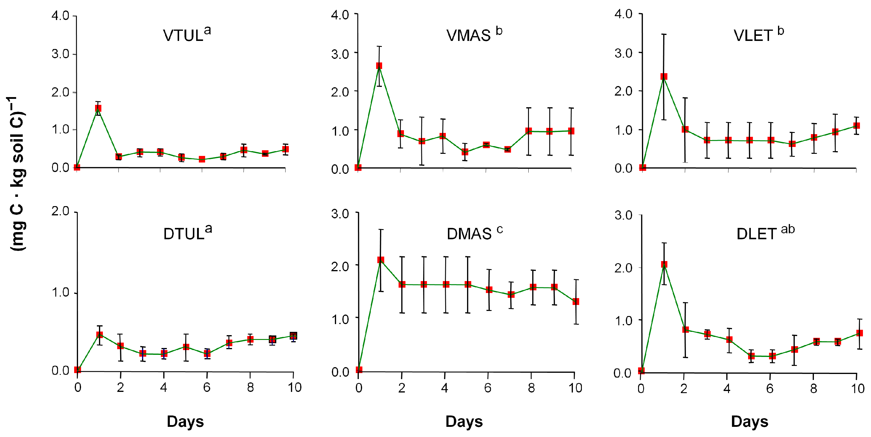
2.3. Soil Respiratory Activity

From in vitro experiments under laboratory conditions, the intrinsic biodegradability of the SOM can be predicted to some extent. Samples of 20 g of dry soil homogenized to 2 mm moistened to 60% of the soil water holding capacity were incubated at 27 ± 1 °C in 250-mL Erlenmeyer flasks, closed with rubber plugs with polyethylene inlet and outlet tubes, and also closed with small plugs [16]. The CO2 released in the course of the mineralization of the SOM was measured daily with a Carmhograph-12 gas analyzer (Wösthoff, Germany). During this operation, the outlet tube was connected to the CO2 analyzer; the inlet tube was connected to a glass column filled with soda lime to provide the flask atmosphere with CO2-free air [17]. The released CO2 was expressed both in absolute terms, i.e., mineralization rate: milligrams of C released per soil weight unit and per day, and in relative terms, i.e., taking into account that each soil had a different SOM content and mineralization coefficient: milligrams of C released per kilogram of soil C and per day.

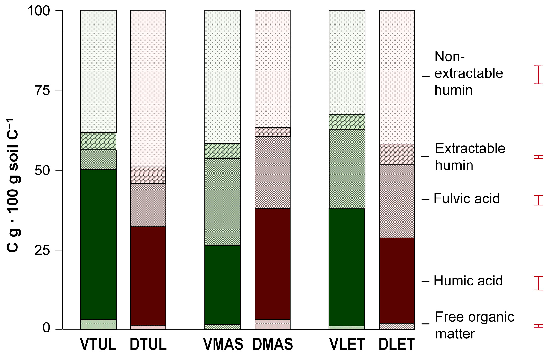
2.4. Soil Humus Fractions

A series of experimental methods reported by Duchaufour and Jacquin [18] have been used to isolate and quantitatively determine the major humus fractions. From samples of 50 g of soil placed in 250 mL centrifuge bottles, a particulate floating fraction with the slightly decomposed organic particles (free organic matter) was separated by flotation in 2 mol L−1 H3PO4 [19] followed by centrifugation at 5000 rpm for 10 min. Then, the soil residue was successively extracted with 0.1 mol L−1 Na4P2O7 Na followed by 0.1 mol L−1 NaOH; this operation was repeated 10 times. Two aliquots of the brown-colored supernatant solution (total humic extract) were isolated; one (50 mL) was precipitated with H2SO4 (1:1 by vol.), centrifuged, and used for the quantitative determination of the acid-insoluble humic acid (HA) fraction. Another aliquot (20 mL) was analyzed for C content as a whole. The difference in C was considered as the fraction of fulvic acid (FA). Finally, the soil organic fraction tightly linked to Al or Fe oxides and to the clay, which is referred to as extractable insolubilized humin [18], was separated from the remaining soil residue by successive treatments with 60 mmol L−1 Na2S2O4 and 1 mol L−1 HCl-HF (1:1 by vol). After repeating the treatment up to 3 times, the colorless supernatant solution was discarded and the soil residue was extracted with 0.1 mol L−1 NaOH to isolate the humic substances that were bound to the soil mineral matrix. For C determination, aliquots of this humic extract containing insolubilized extractable humin were processed as described above.
For further analytical characterization, the HA fraction was purified. After quantitative analysis, the remaining total humic extract was acidified to pH 1 with 6 mol L−1 HCl and centrifuged. The yellowish supernatant solution was discarded and the acid-insoluble HA in the gel state was recovered and redissolved in 0.5 mol L−1 NaOH. This solution was high-speed centrifuged at 43,500× g and the insoluble residue, mainly mineral, was discarded. The brown supernatant solution with the Na-humate was treated with a 1 mol L−1 HCl-HF mixture and the final HA precipitate was recovered and introduced into cellophane bags for exhaustive dialysis until the elimination of the salts (AgNO3 test) introduced during the extraction procedure, desiccated at 40 °C and homogenized.

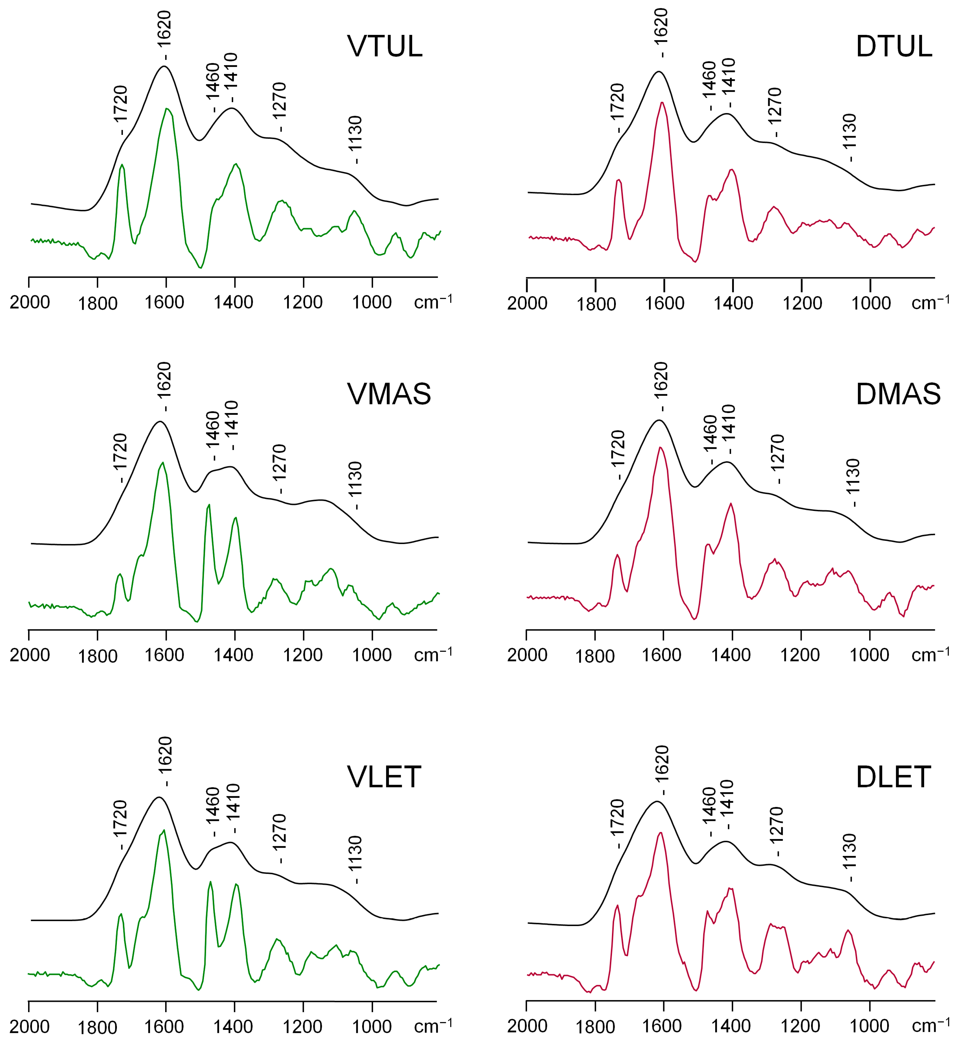
2.5. Humic Acid Characteristics

To determine the optical density of the HA solutions, which is considered an indicator of aromaticity [20] and often referred to as an index of maturity of the SOM, visible spectra were acquired from HA solutions in 0.02 mol L−1 NaHCO3 adjusted to 100 mg C L−1.
The infrared (IR) spectra of the HAs were obtained from KBr pellets (by homogenizing 2.0 mg HA with 200 mg oven-dry KBr) over a wavenumber range of 4000–600 cm−1 in a Bruker IFS28 Fourier transform spectrophotometer (Bruker Spectrospin Ltd., Coventry, UK). Since, as usual in macromolecules, the IR spectra of the HAs consist of broad and overlapped absorption bands, the HA spectra were post-processed using a digital resolution enhancement algorithm based on subtracting a positive multiple of its 2nd derivative from the raw spectrum [21,22].

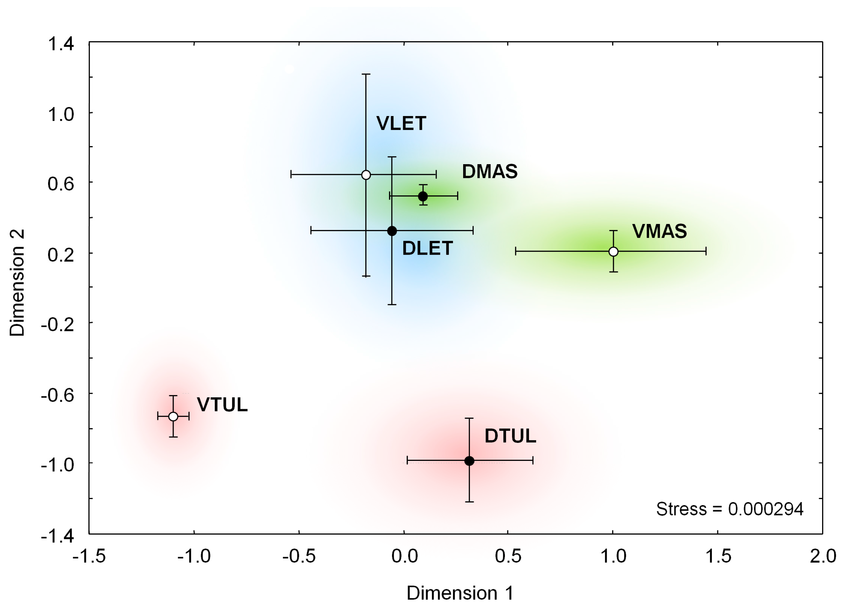
2.6. Statistical Data Treatments

The Least Significant Difference Test [23] was used to compare the significance level of the differences between all the data obtained. A series of multivariate statistical treatments, mainly multidimensional scaling [24], were used to compare changes between non-disturbed and disturbed sites using Euclidean distances to classify cases (sample points) and the 1-Pearson’s r to classify variables (soil descriptors in Table 1, Table 2 and Table 3). Variables were checked for normality and redundant variables were not processed. Data were processed using Statistica 7.1 software (Statsoft. Inc., 2004. Tulsa, OK, USA).

3. Results

3.1. General Characteristics

Table 1 shows a series of routine soil characteristics. The soils showed sandy (Mashangwe and Letlhakeng sites) and sandy loam (Tuli Block site) textures. The clay content was significantly higher in Tuli Block soils VTUL and DTUL (>10%), whereas the differences in clay content between LET and MAS sites were not statistically significant.
At the Tuli Block and Mashangwe sites, soil pH increased as a result of clearing and further disturbance. In Letlhakeng, by contrast, the small increase in soil pH as regards the original savanna ecosystem was not significant.
The undisturbed savanna soils showed a very small amount of SOM, less than 5 g kg−1, which decreases at the cleared DTUL and DMAS sites but remains stable or increases to some extent in the DLET site.
The C/N ratio is low in all sites, as could be expected from semiarid soils with periodically high biological activity. In the LET area, no differences in total N between non-disturbed and disturbed were observed. On the contrary, in the other two plots (TUL and MAS), a significant increase in soil N concentration was observed after disturbance.

3.2. Soil Respiratory Activity

The mineralization curves (Figure 1) calculated in terms of the total C in each soil showed some significant changes due to clearing and cultivation in the case of the MAS site. This soil, which contained the lowest amount of SOM, showed the highest mineralization rate, indicating young SOM or weak organo-mineral interaction or both.

3.3. Soil Organic Matter Fractions

Table 2 shows the distribution of soil C in the different organic fractions. When the data are calculated as percentages of total C (Figure 2), the soils generally show characteristics that suggest high-performance humification processes: a negligible amount of free organic matter (even in non-disturbed savanna) and high HA and humin content (often representing 50% of the total soil C). The soils have a variable content of FAs with HA/FA ratios ranging from 7.25 (VTUL) to 0.93 (VMAS). In particular, the TUL site differs from the MAS and LET sites. In the former, the humus composition suggests more effective organo-mineral interactions and a lower tendency to generate FAs. In contrast, at the other two sites, the HA/FA ratio was several times lower and close to unity, which is more typical of tropical forests with intense SOM mineralization.

3.4. Humic Acid Characteristics

The optical density values of HAs are shown in Table 3 and show high values in the disturbed sites compared to the non-disturbed sites, mainly in the TUL site compared to the other soils. E4/E6 ratios, indicative of polydispersity or molecular size [25], were equally low in all samples (3.5 on average).
The IR spectra (Figure 3 and Figure 4) showed a low-intensity band for carboxyl groups (1720 cm−1) and marked bands for the aromatic (1610–1620 cm−1) and aliphatic (2920 and 1460 cm−1) moieties of the structural backbone. Other bands due to O-containing groups such as 3400 cm−1 (O–H stretching), 1410 cm−1 (vanillyl, syringil aromatic lignin units, and aryl ethers), and 1270 cm−1 (phenolic OH) showed less significant differences between samples.

4. Discussion

4.1. General Characteristics

According to Ringrose et al. [26], the higher SOM content at the TUL site is associated with denser vegetation cover that is connected to a moisture–temperature gradient in the sampling area. In fact, local climatic constraints, namely mainly rainfall variations, have been described as playing an important role in the accumulation of SOM derived from C4 grassland or C4 forest species [27]. In any case, small significant differences in C concentration between non-disturbed and disturbed sites have been previously observed in other southern African soils [28] and attributed to the few inputs in non-disturbed sites because of a loss of litter due to the activity of ungulates and/or termites in the dry season.
Phosphorus pool concentration has been considered a useful proxy for characterizing the whole nutrient distribution in savannas, at least when they are developed under similar bioclimatic constraints [29]. In particular, P has been shown as a limiting nutrient in savanna ecosystems with seasonal dynamics in its cycling [30]. The concentration of P increases in the DTUL site as a probable effect of fertilization, whereas a reduction was observed in the other two disturbed sites. The amounts of K, Ca, Na, and Mg remain more or less constant in all the sites studied. Concerning the amount of microelements, there was a pattern of little significant changes. It is worth indicating that, in general, the TUL sites showed, as in the case of macroelements, the highest natural fertility, given that these fertility patterns, as stated by Chanda et al. [31], closely related to the concentration in the mineralogical constituents of the soil matrix (organic matter and clay) in the studied sites.
The concentration of micronutrients in the three sites studied did not show significant changes after disturbance. In addition, the observed trend toward higher concentrations in soils with a comparatively higher amount of SOM could be interpreted as an indication that most of the potential soil fertility is, at first sight, associated with the resilient organic matter in these soil formations. Nevertheless, the complex history of land use must also be considered at this site, where frequent fallowing and changes in grazing practices [32] are probably causing a sizeable homogenizing effect associated in part with a traditional empiric environmentally friendly management focused to allow the soil to regain its fertility. This fact could also be a consequence of changes in the spatial distribution patterns of wildlife populations that show high mobility in search of food and water [33] in a scenario where crop yields vary negatively over time [34]. It is also possible that substantial migration of soil fertility and pyrogenic C forms was in the form of airborne particles, which can be transported over long distances, and are thought to play an important role in many biogeochemical processes affecting soil properties in Botswana [35].
As a whole, the above results could be interpreted as follows: in the study area, the sites referred to as “virgin“ should not be considered as representative of “undisturbed wilderness“ but rather as “social spaces“ that are communally conceived and preserved [36] and where wildlife conservation coexists with self-sufficient sustainable rural economics. On the other hand, the behavior observed for the SOM and chemical fertility spatial patterns is consistent with the findings by Zhou et al. [37] on rainfall patterns over semi-arid Botswana, indicating that causative mechanisms for rainfall were spatially uniform.

4.2. Soil Respiratory Activity

As the soils were incubated under laboratory conditions, the results are suitable for discussing the relationship between biodegradability and organic matter composition (the maturity of humic substances and therefore their resistance to biodegradation). Even so, the data are consistent with results obtained from in situ measurements in similar soils [38], indicating the importance of sandy texture in accelerating the decomposition of organic matter [38]. In the samples studied, the highest respiration rate was observed in MAS soils, with the highest sand content, while the lowest respiration rate coincided with the TUL zone, with the lowest sand content. In particular, the TUL site differs from the MAS and LET sites. In the former, the humus composition suggests more effective organo-mineral interactions and a lower tendency to generate FAs. In contrast, at the other two sites, the HA/FA ratio was several times lower and close to unity, which is more typical of tropical forests with intense SOM mineralization.
Regarding the molecular composition of the organic matter, it is also noted that the lowest respiration values (i.e., less than 0.5 mg C kg C soil day−1) correspond to soils where HAs are more strongly aromatic (TUL site), suggesting SOM stability against environmental impacts. Conversely, the highest CO2 release is observed in soils where HAs still retain a higher proportion of aliphatic components (MAS and LET sites, with comparatively intense alkyl bands at 2920 and 1460 cm−1).

4.3. Soil Organic Matter Fractions

In particular, the TUL site differs from the MAS and LET sites. In the former, the humus composition suggests more effective organo-mineral interactions and a lower tendency to generate FAs. In contrast, at the other two sites, the HA/FA ratio was several times lower and close to unity, which is more typical of tropical forests with intense SOM mineralization. Regarding the impact of human activities at the TUL site, the disturbance is recognized by an absolute increase (ca. 3 fold) in the FA fraction and an increase in the amount of non-extractable humin. This could be interpreted as a mineralization of the extractable humic substances and a relative enrichment of insoluble defunctionalized SOM associated with the mineral fraction. The other two soils showed relative stability in the SOM; its composition did not show highly significant changes (p < 0.05) when calculated as a percentage of the total soil C.

4.4. Humic Acid Characteristics

The optical density values (Table 3) suggested high stability in the disturbed sites compared to the non-disturbed sites, as it would correspond to a similar degree of aromaticity. When comparing all soils studied, the most significant difference was the higher optical density values at the TUL site compared with the other soils. This coincides with previous data suggesting a comparatively high maturity of the SOM. The E4/E6 ratios were similar in all samples and could be considered relatively low, indicating high macromolecular size and condensation of the HAs [25].
The visual inspection of the infrared spectra clearly shows a relative decrease in the intensity of the alkyl bands in MAS and LET soils (2920 cm−1) after soil disturbance (Figure 3). These changes suggest a depletion of aliphatic structural components with a disturbance at these sites, whereas, at the TUL site, the changes after disturbance were less significant.
Resolution-enhanced spectra were useful for better peak identification and more accurate comparison of peak intensities (Figure 4). These spectra confirm the preservation of aromatic structures (1620, 1410 cm−1) in the SOM of disturbed soils and decreased intensity of aliphatic bands (2920, 1460 cm−1) observed only at MAS and LET sites, a small significant but conspicuous trend at all disturbed sites that could be attributed to the above-suggested enhancement of biogeochemical activity in cultivated sites. Nevertheless, the well-known effect of fire in increasing the aromaticity of the SOM should not be ruled out. At this point, some authors described enhanced aerosol concentrations by biomass burning in the proximity of densely populated areas [39]. The overall results are consistent with those by Dahlberg [40] who found that despite the strong impact of people and livestock on vegetation, most indicators of soil degradation were lacking, suggesting that the land has not lost much of its productive potential. This author concluded that, given the spatial heterogeneity and temporal variation inherent to semi-arid environments, the variations in soil type, rainfall, and vegetation cover partially override the effects of land use. In particular, the feasibility of smallholder farming is a classic controversy in dynamic dryland environments such as the Kalahari.

4.5. Multivariate Data Treatments

The major differences in terms of soil use are summarized in Figure 5, where the intensity of the disturbance and the extent of the spatial variability of the SOM descriptors are represented by the distance between coordinates after multidimensional scaling. It is clear that the largest change (non-disturbed vs. disturbed) occurs at the Tuli Block site and the smallest at the Letlhakeng site (i.e., a scenario where changes in soils were not highly significant when SOM was below a minimal level such as in non-disturbed and disturbed areas at this site).
Regarding the factors related to the maintenance of natural soil fertility and soil C sequestration, Figure 6 clearly shows the soil variables that are more or less significantly correlated with C. Total soil clay and extractable Fe showed a close correlation with soil C, indicating the importance of soil matrix constituents in sandy areas where the above-mentioned mineral fractions are likely to act as limiting factors.
Other factors related to the performance of soil C sequestration in the study sites, but with a lower level of significance, were the concentration of the main macronutrients and non-extractable humin, which could be interpreted as if these surrogates reflected the primary production of the ecosystem, in addition to the role of soil organo-mineral interactions. In general, the results coincided with those reported in Southern African arenosols [41], which described higher SOM contents generally associated with higher values of clay and cation exchange capacity. In fact, SOM and nutrient dynamics, mainly N, in the Kalahari depend more on the rainfall gradient and vegetation composition than on the less significant variation in physical soil properties [13].

Author Contributions

Conceptualization, D.K.; methodology, G.A., D.K. and M.S.; software, G.A.; validation, D.K. and M.S.; formal analysis, G.A.; investigation, D.K., M.S. and G.A.; resources, D.K., M.S. and G.A.; data curation, D.K., M.S. and G.A.; writing—original draft preparation, G.A.; writing—review and editing, D.K., M.S. and G.A.; supervision, D.K. and M.S.; project administration, D.K., M.S. and G.A; funding acquisition, D.K., M.S. and G.A. All authors have read and agreed to the published version of the manuscript.

Funding

Financial support by the European Union (grant INCO-DC, PL-972698) is gratefully acknowledged.

Data Availability Statement

The original contributions presented in the study are included in the article, further inquiries can be directed to the corresponding author.

Acknowledgments

The authors wish to express their sincere gratitude to María T. Pardo, María C. Zancada, and María C. López-Fando (Center of Environmental Sciences, CSIC) for their contributions during the field campaigns or laboratory analyses.

Conflicts of Interest

The authors declare no conflicts of interest.

References

  1. Kgathi, D.L.; Sekhwela, M.B.M.; Tietema, T.; Mpotokwane, M.A. Biomass in Botswana. In Biomass Energy and Coal in Africa; Hall, D.O., Mao, Y.S., Eds.; Zed Books Ltd.: London, UK, 1994. [Google Scholar]
  2. Romanens, R.; Pellacani, F.; Mainga, A.; Fynn, R.; Vittoz, P.; Verrecchia, E.P. Soil diversity and major soil processes in the Kalahari basin, Botswana. Geoderma Reg. 2019, 19, e00236. [Google Scholar] [CrossRef]
  3. Sekhwela, M.B.M. Woody Biomass and Deforestation in Southern African Region: Implications for Global Change Research. In Towards Sustainable Management in the Kalahari Region—Some Essential Background and Critical Issues; Ringrose, S., Raban, C., Eds.; Directorate of Research and Development, University of Botswana: Gaborone, Botswana, 2000; pp. 100–119. [Google Scholar]
  4. Sekhwela, M.B.M.; Yates, D.; Lamb, D. Woody Vegetation Structure and Wood Availability in Arid and Semi-Arid Kalahari Sand System of Botswana. In Towards Sustainable Management in the Kalahari Region—Some Essential Background and Critical Issues; Ringrose, S., Raban, C., Eds.; Directorate of Research and Development, University of Botswana: Gaborone, Botswana, 2000; pp. 65–84. [Google Scholar]
  5. Weinzierl, T.; Wehberg, J.; Böhner, J.; Conrad, O. Spatial assessment of land degradation risk for the Okavango river catchment, southern Africa. Land Degrad. Dev. 2016, 27, 281–294. [Google Scholar] [CrossRef]
  6. Mulale, K.; Chanda, R.; Perkins, J.S.; Magole, L.; Sebego, R.J.; Atlhopheng, J.R.; Mphinyane, W.; Reed, M.S. Formal institutions and their role in promoting sustainable land management in Boteti, Botswana. Land Degrad. Dev. 2014, 25, 80–91. [Google Scholar] [CrossRef]
  7. Perkins, J.; Reed, M.; Akanyang, L.; Atlhopheng, J.; Chanda, R.; Magole, L.; Mphinyane, W.; Mulale, K.; Sebego, R.; Fleskens, L.; et al. Making land management more sustainable: Experience implementing a new methodological framework in Botswana. Land Degrad. Dev. 2013, 24, 463–477. [Google Scholar] [CrossRef]
  8. Stringer, L.C.; Reed, M.S. Land degradation assessment in southern Africa: Integrating local and scientific knowledge bases. Land Degrad. Dev. 2007, 18, 99–116. [Google Scholar] [CrossRef]
  9. Neba, S.C.; Tsheko, R.; Kayombo, B.; Moroke, S.T. Variation of soil organic carbon across different land covers and land uses in the greater Gaborone region of Botswana. World J. Biol. Pharm. Health Sci. 2022, 7, 97–112. [Google Scholar] [CrossRef]
  10. Alemaw, B.F.; Chaoka, T.R.; Totolo, O. Investigation of sustainability of rain-fed agriculture through soil moisture modeling in the Pandamatenga Plains of Botswana. Phys. Chem. Earth Parts A/B/C 2006, 31, 960–966. [Google Scholar] [CrossRef]
  11. Neba, S.C.; Tsecko, R. Spatial and temporal variation of soil properties and soil organic carbon in semi-arid areas of Sub-Sahara Africa. Geoderma Reg. 2024, 36, e00770. [Google Scholar]
  12. Almendros, G.; Kgathi, D.; Sekhwela, M.; Zancada, M.C.; Tinoco, P.; Pardo, M.T. Biogeochemical assessment of resilient humus formations from virgin and cultivated northern Botswana soils. J. Agric. Food Chem. 2003, 51, 4321–4330. [Google Scholar] [CrossRef]
  13. Wang, L.; D’Odorico, P.; Ringrose, S.; Coetzee, S.; Macko, S.A. Biogeochemistry of Kalahari sands. J. Arid Environ. 2007, 71, 259–279. [Google Scholar] [CrossRef]
  14. Lyndsay, W.L.; Norvell, W.A. Development of a DTPA soil test for zinc, iron, manganese and copper. Soil Sci. Soc. Am. J. 1978, 42, 421–428. [Google Scholar] [CrossRef]
  15. Nelson, D.V.; Sommers, L.E. Total carbon, organic carbon and organic matter. In Methods of Soil Analysis: Part 2, Chemical and Microbiological Properties, 2nd ed.; Page, A.L., Miller, R.H., Keeney, D.R., Eds.; American Society of Agronomy: Madison, WI, USA, 1982; pp. 539–579. [Google Scholar]
  16. Chone, T.; Jacquin, F.; Yaghi, M. Emploi de 14C et 45Ca comme éléments traceurs de l’humification. Bull. ENSAIA 1973, 15, 69–83. [Google Scholar]
  17. Almendros, G.; González Vila, F.J.; Martin, F. Fire induced transformation of soil organic matter from an oak forest. An experimental approach to the effects of fire on humic substances. Soil Sci. 1990, 149, 158–168. [Google Scholar] [CrossRef]
  18. Duchaufour, P.; Jacquin, F. Comparaison des processus d’humification dans les principaux types d’humus forestiers. Bull. AFES 1975, 1975, 29–36. [Google Scholar]
  19. Dabin, B. Étude d’une méthode d’extraction de la matière humique du sol. Sci. Sol. 1971, 2, 15–24. [Google Scholar]
  20. Traina, S.; Novak, J.; Smeck, N.E. An ultraviolet absorbance method of estimating the percent aromatic carbon content of humic acids. J. Environ. Qual. 1990, 19, 151–153. [Google Scholar] [CrossRef]
  21. Rosenfeld, A.; Kak, A.C. Digital Picture Processing; Academic Press: New York, NY, USA, 1982; Volume I. [Google Scholar]
  22. Almendros, G.; Sanz, J. A structural study of alkyl polymers in soil after perborate degradation of humin. Geoderma 1992, 53, 79–95. [Google Scholar] [CrossRef]
  23. Fisher, R.A. The Design of Experiments; Oliver and Boyd Ltd.: Edinburgh, UK, 1949. [Google Scholar]
  24. Kruskal, J.B. Multidimensional scaling by optimizing goodness of fit to a nonmetric hypothesis. Psychometrika 1964, 29, 1–27. [Google Scholar] [CrossRef]
  25. Chen, Y.; Senesi, N.; Schnitzer, M. Information provided on humic substances by E4/E6 ratios. Soil Sci. Soc. Am. J. 1977, 41, 352–358. [Google Scholar] [CrossRef]
  26. Ringrose, S.; Matheson, W.; Wolski, P.; Huntsman-Mapila, P. Vegetation cover trends along the Botswana Kalahari transect. J. Arid Environ. 2003, 54, 297–317. [Google Scholar] [CrossRef]
  27. Wang, L.; Okin, G.S.; Caylor, K.K.; Macko, S.A. Spatial heterogeneity and sources of soil carbon in southern African savannas. Geoderma 2009, 149, 402–408. [Google Scholar] [CrossRef]
  28. Feral, C.J.W.; Epstein, H.E.; Otter, L.; Aranibar, J.N.; Shugart, H.H.; Macko, S.A.; Ramontsho, J. Carbon and nitrogen in the soil–plant system along rainfall and land-use gradients in southern Africa. J. Arid Environ. 2003, 54, 327–343. [Google Scholar] [CrossRef]
  29. O’Halloran, L.R.; Shugart, H.H.; Wang, L.; Caylor, K.K.; Ringrose, S.; Kgope, B. Nutrient limitations on aboveground grass production in four savanna types along the Kalahari Transect. J. Arid Environ. 2010, 74, 284–290. [Google Scholar] [CrossRef]
  30. Wang, L.; D’Odorico, P.; Okin, G.S.; Macko, S.A. Isotope composition and anion chemistry of soil profiles along the Kalahari Transect. J. Arid Environ. 2009, 73, 480–486. [Google Scholar] [CrossRef]
  31. Chanda, R.; Totolo, O.; Moleele, N.; Setshogo, M.; Mosweu, S. Prospects for subsistence livelihood and environmental sustainability along the Kalahari Transect: The case of Matsheng in Botswana’s Kalahari rangelands. J. Arid Environ. 2003, 54, 425–445. [Google Scholar] [CrossRef]
  32. Mmopelwa, G. Factors contributing to land fallowing in a permanent cultivation system: The case of semi-arid Botswana. J. Arid Environ. 1998, 40, 211–216. [Google Scholar] [CrossRef]
  33. Verlinden, A. Human settlements and wildlife distribution in the southern Kalahari of Botswana. Biol. Conserv. 1997, 82, 129–136. [Google Scholar] [CrossRef]
  34. Seleka, T.B. The performance of Botswana’s traditional arable agriculture: Growth rates and the impact of the accelerated rainfed arable programme (ARAP). Agric. Econ. 1999, 20, 121–133. [Google Scholar] [CrossRef]
  35. Humphries, M.S.; McCarthy, T.S.; Cooper, G.R.J.; Stewart, R.A.; Stewart, R.D. The role of airborne dust in the growth of tree islands in the Okavango Delta, Botswana. Geomorphology 2014, 206, 307–317. [Google Scholar] [CrossRef]
  36. Twyman, C.; Sporton, D.; Thomas, D.S.G. ‘Where is the life in farming?’: The viability of smallholder farming on the margins of the Kalahari, Southern Africa. Geoforum 2004, 35, 69–85. [Google Scholar] [CrossRef]
  37. Zhou, X.; Persaud, N.; Wang, H. Periodicities and scaling parameters of daily rainfall over semi-arid Botswana. Ecol. Model. 2005, 182, 371–378. [Google Scholar] [CrossRef]
  38. Thomas, A.D. Impact of grazing intensity on seasonal variations in soil organic carbon and soil CO2 efflux in two semiarid grasslands in southern Botswana. Philos. Trans. R. Soc. Lond. B Biol. Sci. 2012, 367, 3076–3086. [Google Scholar] [CrossRef]
  39. Jayaratne, E.R.; Verma, T.S. The impact of biomass burning on the environmental aerosol concentration in Gaborone, Botswana. Atmos. Environ. 2001, 35, 1821–1828. [Google Scholar] [CrossRef]
  40. Dahlberg, A.C. Vegetation diversity and change in relation to land use, soil and rainfall—A case study from North-East District, Botswana. J. Arid Environ. 2000, 44, 19–40. [Google Scholar] [CrossRef]
  41. Hartemink, A.E.; Huting, J. Land cover, extent, and properties of arenosols in Southern Africa. Arid Land. Res. Manag. 2008, 22, 134–147. [Google Scholar] [CrossRef]
Figure 1. Carbon mineralization curves of soils from south-eastern Botswana (the error bars on the curves for daily mineralization show the average variability range between four soil samples collected at different sites). Soil labels refer to the Material and Methods section (prefixes V and D refer to virgin (non-disturbed) and disturbed sites, respectively). The lowercase letters after the soil labels indicate the significance level between the average respiration (e.g., mg C/kg C soil/day) of the soil spatial replicates; soil labels followed by the same letter are not significantly different at p < 0.05.
Agronomy 14 01869 g001
Figure 2. Average values for the major humus fractions in soils from south-eastern Botswana. Soil labels refer to the Material and Methods section. Prefixes V (green bars) and D (red bars) refer to virgin (non-disturbed) and disturbed sites, respectively. Error bars correspond to the value of the least significant difference (p < 0.05) between samples calculated from spatial replications.
Agronomy 14 01869 g002
Figure 3. Fourier-transform infrared spectra of humic acids from non-disturbed (green, V-) and disturbed (red, D-) soils from south-eastern Botswana. Soil labels refer to the Material and Methods section.
Agronomy 14 01869 g003
Figure 4. Fourier-transform infrared spectra and resolution-enhanced infrared spectra (below) of humic acids from non-disturbed (left, green) and disturbed (right, red) soils from south-eastern Botswana. Soil labels refer to the Material and Methods section.
Agronomy 14 01869 g004
Figure 5. Multidimensional scaling used for the classification of soil samples based on Euclidean distances between soil organic matter descriptors (C, C/N ratio, humic fractions, and characteristics in Table 2 and Table 3). Distance in the plane between centroids for the different sites (blue, green and red colors) is proportional to changes between non-disturbed (V: open circles as centroids) and disturbed (D: solid circles as centroids) sites. Error bars indicate the space occupied by four spatial replications.
Agronomy 14 01869 g005
Figure 6. Classification of soil descriptors correlated with soil organic C (Soil C, C/N ratio, humic fractions, acronyms indicated in Table 2 and Table 3). Encircled variables showed correlations at p < 0.05 (dashed lines) or p < 0.01 (continuous line). The scatterdiagram was obtained by multidimensional scaling from the similarity matrix between pairs of variables using the 1-Pearson r index.
Agronomy 14 01869 g006
Table 1. General analytical characteristics of the Botswanian soils (0–10 cm) studied.
Sampling Sites a VTULDTULVMASDMASVLETDLETLSD
Sand (2–0.02 mm)/g kg−1795 a790 a910 b860 c880 d883 d18
Silt (0.02–0.002 mm)90 a100 a38 b85 c63 d65 d13
Clay (<0.002 mm)115 a110 a53 b55 b58 b53 b14
pH (H2O) 6.8 a7.4 a6.2 b6.9 a7.0 a7.2 a1.1
pH (KCl) 5.2 a5.9 a4.6 a5.4 a5.5 a5.6 a1.3
Soil C/g kg−14.25 a3.8 a2.0 b1.25 b1.75 b2.55 b1.5
Soil N0.31 a0.42 b0.25 a0.36 ab0.33 ab0.31 a0.1
C/N ratio 13.7 a9.0 b8.1 b4.7 c5.3 c8.2 b3.3
P/mg kg−14.9 a8.7 b5.7 c3.8 d10.9 e6.9 f0.4
K176.2 a182.5 a85 b98.7 b110 b132.5 ab59.0
Ca715.0 a613.3 a278.7 b395.0 bc353.3 bc573.7 bc236.0
Na7.5 a5.0 b5.0 b6.2 ab5.0 b5.0 b1.9
Mg79.0 a78.2 a15.3 b31.3 b49.2 ab71.2 ab29.8
Fe11.4 a14.5 a3.8 b4.3 b6.9 b9.1 ab3.7
Mn29.5 a6.4 b16.7 ba14.0 ba15.5 ba39.5 a18.7
Zn<0.4<0.4<0.4<0.4<0.4<0.4<0.4
Cu<0.4<0.4<0.4<0.4<0.4<0.4<0.4
TUL = Tuli Block; MAS = Mashangwe; LET = Letlhakeng (Prefixes V and D refer to virgin (non-disturbed) and disturbed sites, respectively). LSD = Least significant difference between replicated samples taken in the sites studied (p < 0.05). Means followed by the same letter within a row are not significantly different.
Table 2. Organic fractions in the Botswanian soils (0–10 cm) were studied.
Sampling Sites aFree Organic Matter bTotal Humic Extract bHumic Acid bFulvic Acid bHumic Acid/Fulvic Acid RatioInsolubilized Extractable Humin bNon-Extractable Humin b
VTUL0.122.272.000.267.250.231.63
DTUL0. 041.701.170.522.210.201.87
VMAS0.031.040.500.550.930.090.84
DMAS0.030.720.440.281.790.040.46
VLET0.021.080.640.441.470.080.57
DLET0.041.270.690.581.190.171.07
LSD (p < 0.05)0.020.820.740.131.550.040.72
a TUL = Tuli Block; MAS = Mashangwe; LET = Letlhakeng; (prefixes V and D refer to virgin (non-disturbed) and disturbed sites, respectively). LSD = Least significant difference between spatial replications of the sampled soils (p < 0.05); b g C kg−1 soil.
Table 3. Spectroscopic parameters of humic acids from the Botswanian soils studied.
Optical Density a Values in the Visible Range (Wavelength nm)Optical Density Values b of the Main Bands (Wavelength cm−1)
in the Infrared Spectra
SampleE4E4/E63400
O–H Stretching
2920
C–H Stretching
1720
Carboxyl Acids
VTUL2.163.30.930.980.93
DTUL2.163.40.941.000.84
VMAS2.233.61.111.890.80
DMAS1.583.51.171.270.89
VLET1.653.81.111.790.96
DLET1.473.51.021.090.83
LSD (p < 0.05)1.490.08
a Measured at concentration 100 mg C L−1; b Relative to the intensity of the 1510 cm−1 band; LSD = Least significant difference between spatial replications of the sampled soils (p < 0.05).
Disclaimer/Publisher’s Note: The statements, opinions and data contained in all publications are solely those of the individual author(s) and contributor(s) and not of MDPI and/or the editor(s). MDPI and/or the editor(s) disclaim responsibility for any injury to people or property resulting from any ideas, methods, instructions or products referred to in the content.

