The Combination of Wildfire and Changing Climate Triggers Permafrost Degradation in the Khentii Mountains, Northern Mongolia


Abstract
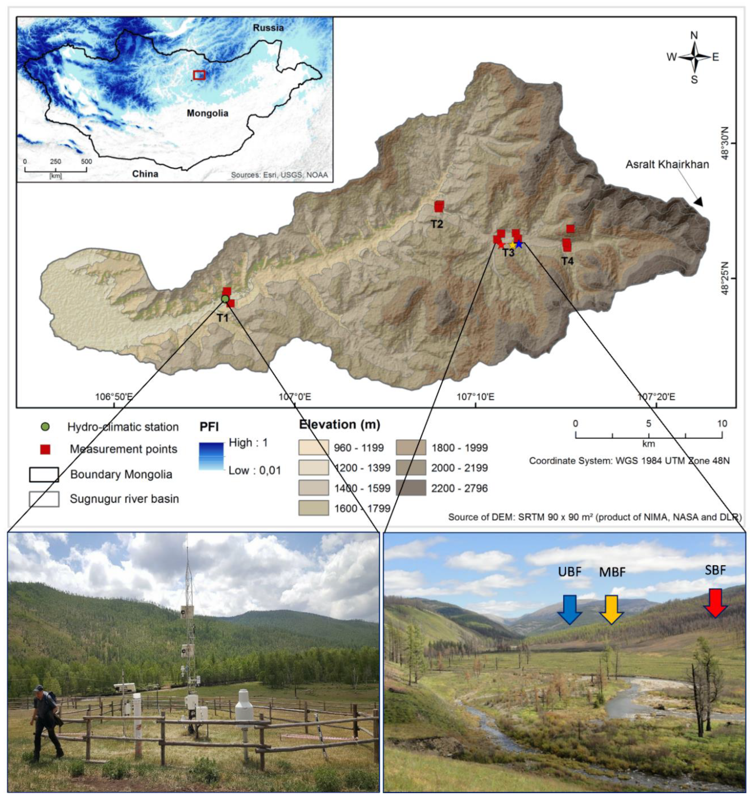
:1. Introduction
2. Materials and Methods
3. Results and Discussion
3.1. Temperature Variability
3.2. Response of Ground Hydrothermal Regime to Climtaic Variability
3.3. Impact of Wildfire on Active Layer Dynamics
4. Conclusions
Supplementary Materials
Author Contributions
Funding
Acknowledgments
Conflicts of Interest
References
- Osterkamp, T.E.; Romanovsky, V.E. Evidence for Warming and Thawing of Discontinuous Permafrost in Alaska. Permafr. Periglac. Process. 1999, 10, 17–37. [Google Scholar] [CrossRef]
- Yoshikawa, K.; Bolton, W.R.; Romanovsky, V.E.; Fukuda, M.; Hinzman, L.D. Impacts of wildfire on the permafrost in the boreal forests of Interior Alaska. J. Geophys. Res. 2002, 108, D18148. [Google Scholar] [CrossRef] [Green Version]
- Tchebakova, N.M.; Parfenova, E.; Soja, A.J. The effects of climate, permafrost and fire on vegetation change in Siberia in a changing climate. Environ. Res. Lett. 2009, 4, 045013. [Google Scholar] [CrossRef]
- Ishikawa, M.; Jambaljav, Y.; Dashtseren, A.; Sharkhuu, N.; Davaa, G.; Ijima, Y.; Baatarbileg, N.; Yoshikawa, K. Thermal states, responsiveness and degradation of marginal permafrost in Mongolia. Permafr. Periglac. Process. 2018, 29, 271–282. [Google Scholar] [CrossRef]
- Biskaborn, B.K.; Smith, S.L.; Noetzli, J.; Matthes, H.; Viera, G.; Streletskiy, D.A.; Schoeneich, P.; Romanovsky, V.E.; Lewkowicz, A.G.; Abramov, A.; et al. Permafrost is warming at a global scale. Nat. Commun. 2019, 10, 264. [Google Scholar] [CrossRef] [PubMed] [Green Version]
- Mongolian Second Assessment Report on Climate Change (MARCC); Ministry of Environment and Green Development: Ulaanbaatar, Mongolia, 2014.
- Hansen, J.; Ruedy, R.; Sato, M.; Lo, K. Global surface temperature change. Rev. Geophys. 2010, 48, RG4004. [Google Scholar] [CrossRef] [Green Version]
- Smith, M.W.; Riseborough, D.W. Climate and the Limits of Permafrost: A Zonal Analysis. Permafr. Periglac. Process. 2002, 13, 1–15. [Google Scholar] [CrossRef]
- Walvoord, M.A.; Kurylyk, B.L. Hydrologic Impacts of Thawing Permafrost—A Review. Vadose Zone J. 2016, 15, 1–20. [Google Scholar] [CrossRef]
- Bartsch, A.; Balzter, H.; George, C. The influence of regional surface soil moisture anomalies on forest fires in Siberia observed from satellites. Environ. Res. Lett. 2009, 4, 045021. [Google Scholar] [CrossRef] [Green Version]
- Jafarov, E.E.; Romanovsky, V.E.; Genet, H.; McGuire, A.D.; Marchenko, S.S. The effects of fire on the thermal stability of permafrost in lowland and upland black spruce forests of interior Alaska in a changing climate. Environ. Res. Lett. 2013, 8, 35030. [Google Scholar] [CrossRef]
- Gibson, C.M.; Chasmer, L.E.; Thompson, D.K.; Quinton, W.L.; Flannigan, M.D.; Olefeldt, D. Wildfire as a major driver of recent permafrost thaw in boreal peatlands. Nature Commun. 2018, 9, 3041. [Google Scholar] [CrossRef] [PubMed] [Green Version]
- Connon, R.; Devoie, É.; Hayashi, M.; Veness, T.; Quinton, W. The influence of shallow taliks on permafrost thaw and active layer dynamics in subarctic Canada. J. Geophys. Res. Earth Surface 2018, 123, 281–297. [Google Scholar] [CrossRef]
- Brown, D.R.N.; Jorgenson, M.T.; Douglas, T.A.; Romanovsky, V.E.; Kielland, K.; Hiemstra, C.; Euskirchen, E.S.; Ruess, R.W. Interactive effects of wildfire and climate on permafrost degradation in Alaskan lowland forests. J. Geophys. Res. Biogeosciences 2015, 120, 1619–1637. [Google Scholar] [CrossRef]
- Jiang, Y.; Rocha, A.V.; Donnell, J.A.O.; Drysdale, J.A.; Rastetter, E.B.; Shaver, G.R.; Zhuang, Q.J. Contrasting soil thermal responses to fire in Alaskan tundra and boreal forest. Geophys. Res. Earth Surface 2015, 120, 363–378. [Google Scholar] [CrossRef] [Green Version]
- Yi, S.; McGuire, A.D.; Harden, J.; Kasischke, E.; Manies, K.; Hinzman, L.; Liljedahl, A.; Randerson, J.; Liu, H.; Romanovsky, V.; et al. Interactions between soil thermal and hydrological dynamics in the response of Alaska ecosystems to fire disturbance. J. Geophys. Res. 2009, 114, G02015. [Google Scholar] [CrossRef] [Green Version]
- Hayashi, M.; Goeller, N.; Quinton, W.L.; Wright, N. A simple heat-conduction method for simulating the frost-table depth in hydrological models. Hydrol. Process. 2007, 21, 2610–2622. [Google Scholar] [CrossRef]
- Kopp, B.J.; Lange, J.; Menzel, L. Effects of wildfire on runoff generating processes in northern Mongolia. Reg. Environ. Change 2016, 17, 1951–1963. [Google Scholar] [CrossRef]
- Alexander, H.D.; Natali, S.M.; Loranty, M.M.; Ludwig, S.M.; Spektor, V.V.; Davydov, S.; Zimov, N.; Trujillo, I.; Mack, M.C. Impacts of increased soil burn severity on larch forest regeneration on permafrost soils of far northeastern Siberia. For. Ecol. Manag. 2018, 417, 144–153. [Google Scholar] [CrossRef]
- Ebel, B.A.; Moody, J.A.; Martin, D.A. Hydrologic conditions controlling runoff generation immediately after wildfire. Water Resour. Res. 2012, 48, W03529. [Google Scholar] [CrossRef]
- Nossov, D.R.; Jorgenson, M.T.; Kielland, K.; Kanevskiy, M. Edaphic and microclimatic controls over permafrost response to fire in interior Alaska. Environ. Res. Lett. 2013, 8, 35013. [Google Scholar] [CrossRef]
- Semenova, O.; Lebedeva, L.; Volkova, N.; Korenev, I.; Forkel, M.; Eberle, J.; Urban, M. Detecting immediate wildfire impact on runoff in a poorly-gauged mountainous permafrost basin. Hydrolog. Sci. J. 2015, 60, 1225–1241. [Google Scholar] [CrossRef]
- Debano, L.F. The role of fire and soil heating on water repellency in wildland environments: A review. J. Hydrol. 2000, 231–232, 195–206. [Google Scholar] [CrossRef]
- Wondzell, S.M.; King, J.G. Postfire erosional processes in the Pacific Northwest and Rocky Mountain regions. Forest Ecol. Manag 2003, 178, 75–87. [Google Scholar] [CrossRef]
- Bodi, M.B.; Doerr, S.H.; Cerdà, A.; Mataix-solera, J. Effects of a layer of vegetative ash layer on wettable and water repellent soil hydrology. Geoderma 2012, 191, 14–23. [Google Scholar] [CrossRef]
- Ishikawa, M.; Zhang, Y.; Kadota, T.; Ohata, T. Hydrothermal regimes of the active layer. Water Resour. Res. 2006, 42, W04401. [Google Scholar] [CrossRef]
- Dashtseren, A.; Ishikawa, M.; Iijima, Y.; Yamkhin, J. Temperature regimes of the active layer and seasonally frozen ground under a forest-steppe mosaic, Mongolia. Permafr. Periglac. Process. 2014, 25, 295–306. [Google Scholar] [CrossRef]
- Munkhjargal, M.; Groos, S.; Pan, C.G.; Yadamsuren, G.; Yamkhin, J.; Menzel, L. Multi-source based spatio-temporal distribution of snow in a semi-arid headwater catchment of Northern Mongolia. Geosciences 2019, 9, 53. [Google Scholar] [CrossRef] [Green Version]
- Munkhjargal, M.; Menzel, L. Estimating daily average net radiation in Northern Mongolia. Geograf. Ann. A 2019, 10, 177–194. [Google Scholar] [CrossRef]
- Lange, J.; Kopp, B.J.; Bents, M.; Menzel, L. Tracing variability of run-off generation in mountainous permafrost of semi-arid north-eastern Mongolia. Hydrol. Process. 2015, 29, 1046–1055. [Google Scholar] [CrossRef]
- Menzel, L.; Hofmann, J.; Ibisch, R. Studies of water and mass fluxes to provide a basis for an Integrated Water Resources Management (IWRM) in the catchment of the River Kharaa in Mongolia. Hydrologie und Wasserbewirtschaftungy 2011, 55, 88–103. [Google Scholar]
- Shur, Y.L.; Jorgenson, M.T. Patterns of permafrost and degradation in relation to climate and ecosystems. Permafr. Periglac. Process. 2007, 18, 7–19. [Google Scholar] [CrossRef]
- Kopp, B.J.; Minderlein, S.; Menzel, L. Soil Moisture Dynamics in a Mountainous Headwater Area in the Discontinuous Permafrost Zone of northern Mongolia. Arct. Antarct. Alp. Res. 2014, 46, 459–470. [Google Scholar] [CrossRef] [Green Version]
- Gruber, S. The Cryosphere Derivation and analysis of a high-resolution estimate of global permafrost zonation. Cryosphere 2010, 6, 221–233. [Google Scholar] [CrossRef] [Green Version]
- Minderlein, S.; Menzel, L. Evapotranspiration and energy balance dynamics of a semi-arid mountainous steppe and shrubland site in Northern Mongolia. Environ. Earth Sci. 2014, 73, 593–609. [Google Scholar] [CrossRef]
- Stefan, J. Über die Theorie der Eisbildung, insbesondere über die Eisbildung im Polarmee. Ann. Phys. Chem. 1891, 278, 269–286. [Google Scholar] [CrossRef] [Green Version]
- Groisman, P.V.; Blyakharchuk, T.A.; Chernokulsky, A.V.; Arzhanov, M.M.; Marchesini, L.B.; Bogdanova, E.G.; Borzenkova, I.; Bulygina, O.N.; Karpenko, A.A.; Karpenko, L.V.; et al. Climate changes in Siberia. In Regional Environmental Changes in Siberia and Their Global Consequences; Groisman, P., Gutman, G., Eds.; Springer Environmental Science and Engineering, Springer: Dordrecht, The Netherlands, 2013; pp. 57–109. ISBN 978-94-007-4569-8. [Google Scholar]
- Ponomarev, E.I.; Kharuk, V.I.; Ranson, K.J. Wildfires dynamics in siberian larch forests. Forests 2016, 7, 125. [Google Scholar] [CrossRef] [Green Version]
- Kukavskaya, E.A.; Buryak, L.V.; Shvetsov, E.G.; Conard, S.G.; Kalenskaya, O.P. The impact of increasing fire frequency on forest transformations in southern Siberia. Forest Ecol. Manag. 2016, 382, 225–235. [Google Scholar] [CrossRef]
- Kharuk, V.I.; Ranson, K.J.; Dvinskaya, M.L.; Im, S.T. Wildfires in northern Siberian larch dominated communities. Environ. Res. Lett. 2011, 6, 045208. [Google Scholar] [CrossRef]
- Kasischke, E.S.; Johnstone, J.F. Variation in postfire organic layer thickness in a black spruce forest complex in interior Alaska and its effects on soil temperature and moisture. Can. J. For. Res. 2005, 35, 2164–2177. [Google Scholar] [CrossRef]
- Chambers, S.D.; Beringer, J.; Randerson, J.T.; Chapin III, F.S. Fire effects on net radiation and energy partitioning: Contrasting responses of tundra and boreal forest ecosystems. J. Geophys. Res. Atmos. 2005, 110, D09106. [Google Scholar] [CrossRef]
- Quinton, W.L.; Shirazi, T.; Carey, S.K.; Pomeroy, J.W. Soil Water Storage and Active-layer Development in a Sub-alpine Tundra Hillslope, Southern Yukon Territory, Canada. Permafr. Periglac. Process. 2005, 16, 369–382. [Google Scholar] [CrossRef]
- Watanabe, K.; Kito, T.; Dun, S.; Wu, J.Q.; Greer, R.C.; Flury, M. Water infiltration into a frozen soil with simultaneous melting of the frozen layer. Vadose Zone 2012, 12. [Google Scholar] [CrossRef]
- Romanovsky, V.E.; Osterkamp, T.E. Effects of Unfrozen Water on Heat and Mass Transport Processes in the Active Layer and Permafrost. Permafr. Periglac. Process. 2000, 11, 219–239. [Google Scholar] [CrossRef]
- Scherler, M.; Hauck, C.; Hoelzle, M.; Stähli, M.; Völksch, I. Meltwater Infiltration into the Frozen Active Layer at an Alpine Permafrost Site. Permafr. Periglac. Process. 2010, 21, 325–334. [Google Scholar] [CrossRef] [Green Version]
- Barret, K.; McGuire, A.D.; Hoy, E.E.; Kasischke, E.S. Potential shifts in dominant forest cover in interior Alaska driven by variations in fire severity. Ecol. App. 2011, 21, 2380–2396. [Google Scholar] [CrossRef]


| Abbreviation | Explanation | Abbreviation | Explanation |
|---|---|---|---|
| MAAT | Mean annual air temperature | MBF | Moderate burned forest |
| GST | Ground surface temperature | TDDs | Surface thawing degree-days |
| ASD | Accumulated snow depth | FDDs | Surface freezing degree-days |
| K | Soil thermal conductivity | SWC | Soil water content |
| SBF | Severely burned forest | MAGT | Mean annual ground temperature |
| UBF | Unburned forest | SCD | Snow cover duration |
| T | Altitude (m) | Aspect | Vegetation Type | Field Measurements | PSR | |||||
|---|---|---|---|---|---|---|---|---|---|---|
| TDDs (°C) | FDDs (°C) | K (Wm−1∙K−1) | Biomass (kg/m2) | ASD (cm) | W∙m−2 | |||||
| 1 | 1 | 1281 | South | Sparse vegetation | 3391 | −1000 | 0.56 | 0.035 | - | 182 |
| 2 | 1193 | Valley | Short grass | 2770 | −948 | 0.7 | 0.06 | 23 | 175 | |
| 3 | 1281 | North | Sparse forest | 1869 | −1123 | 0.79 | 2.21 | 26 | 134 | |
| 4 | 2 | 1393 | South | Sparse vegetation | 2905 | −1548 | 0.58 | 0.24 | 0 | 172 |
| 5 | 1356 | Valley | Shrub | 2141 | −1597 | 0.78 | 0.875 | 20 | 145 | |
| 6 | 1393 | North | Dense forest | 1498 | −1356 | 0.72 | 3.975 | 22 | 111 | |
| 7 | 3 | 1558 | South | Sparse vegetation | 2690 | −905 | 0.68 | 0.135 | 0 | 190 |
| 8 | 1485 | Valley | Shrub | 2326 | −1326 | 0.57 | 0.825 | 25 | 161 | |
| 9 | 1558 | North | UBF | 1647 | −1282 | 0.73 | 4.95 | 21 | 149 | |
| 10 | 1530 | North | SBF | - | - | 1.15 | 2.46 | 27 | 158 | |
| 11 | 4 | 1583 | Valley | Shrub | 1482 | −1855 | 0.69 | 1.67 | 12 | 148 |
| 12 | 1612 | North | Sparse forest | 2050 | −1322 | 0.5 | 2.43 | 25 | 140 | |
| 13 | 2020 | Mnt. | Rock | 1705 | −956 | - | - | - | 196 | |
| Year | Hydro-Climatic Station | UBF (u) and SBF (s) Sites | |||||||
|---|---|---|---|---|---|---|---|---|---|
| TDDa (°C) | FDDa (°C) | nf (-) | ASD (cm) | SCD (day) | Prec. (mm) | FDDs (°C) | TDDs (°C) | ASD (cm) | |
| 2015–2016 | 2240 | −2604 | 0.5 | 18 | 127 | 382 | nau/ncs | ncu/1604s | na |
| 2016–2017 | 2288 | −2459 | 0.46 | 22 | 141 | 323 | −1318u/−1140s | 1402u/1715s | 25u/27s |
| 2017–2018 | nc | −2687 | 0.4 | 31 | 123 | >423 | −1166u/−913s | 1525u/1643s | 35u/35s |
| 2018–2019 | na | na | na | 5 | na | na | −1299u/−1006s | ncu/ncs | 19u/26s |
| Site | 2016 | 2017 | 2018 | Observed |
|---|---|---|---|---|
| UBF | - | 1.3 | 1.3 | >1.2 |
| SBF | 2.1 | 2.2 | 2.1 | ~2.9 |
© 2020 by the authors. Licensee MDPI, Basel, Switzerland. This article is an open access article distributed under the terms and conditions of the Creative Commons Attribution (CC BY) license (http://creativecommons.org/licenses/by/4.0/).
Share and Cite
Munkhjargal, M.; Yadamsuren, G.; Yamkhin, J.; Menzel, L. The Combination of Wildfire and Changing Climate Triggers Permafrost Degradation in the Khentii Mountains, Northern Mongolia. Atmosphere 2020, 11, 155. https://doi.org/10.3390/atmos11020155
Munkhjargal M, Yadamsuren G, Yamkhin J, Menzel L. The Combination of Wildfire and Changing Climate Triggers Permafrost Degradation in the Khentii Mountains, Northern Mongolia. Atmosphere. 2020; 11(2):155. https://doi.org/10.3390/atmos11020155
Chicago/Turabian StyleMunkhjargal, Munkhdavaa, Gansukh Yadamsuren, Jambaljav Yamkhin, and Lucas Menzel. 2020. "The Combination of Wildfire and Changing Climate Triggers Permafrost Degradation in the Khentii Mountains, Northern Mongolia" Atmosphere 11, no. 2: 155. https://doi.org/10.3390/atmos11020155