
The Representation of the Southern Annular Mode Signal in the Brazilian Earth System Model


Abstract
:1. Introduction
2. Materials and Methods
2.1. Brazilian Earth System Model (BESM)
2.2. CMIP5 Models Outputs
2.3. Observations and Reanalysis
2.4. SAM Indices
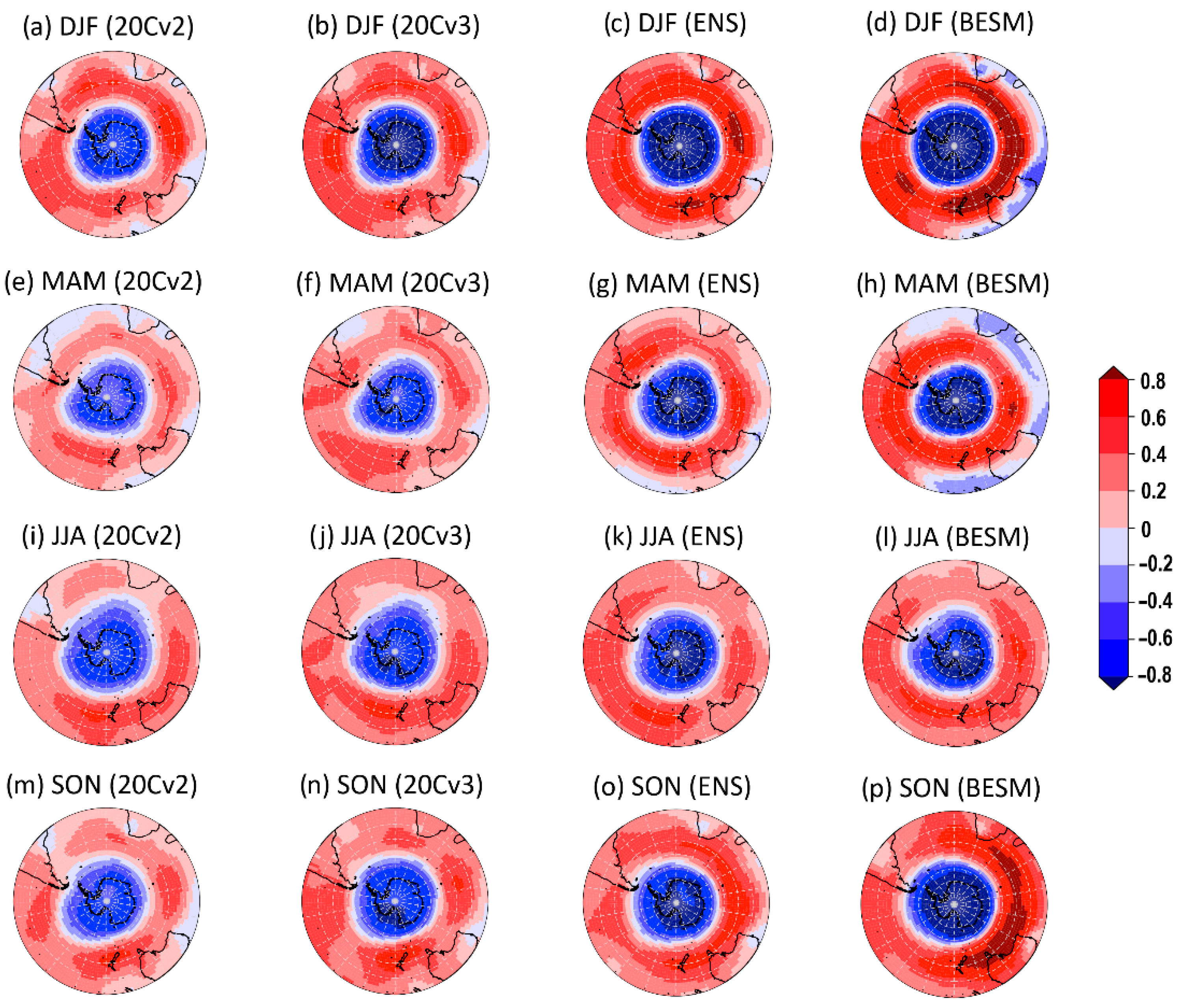
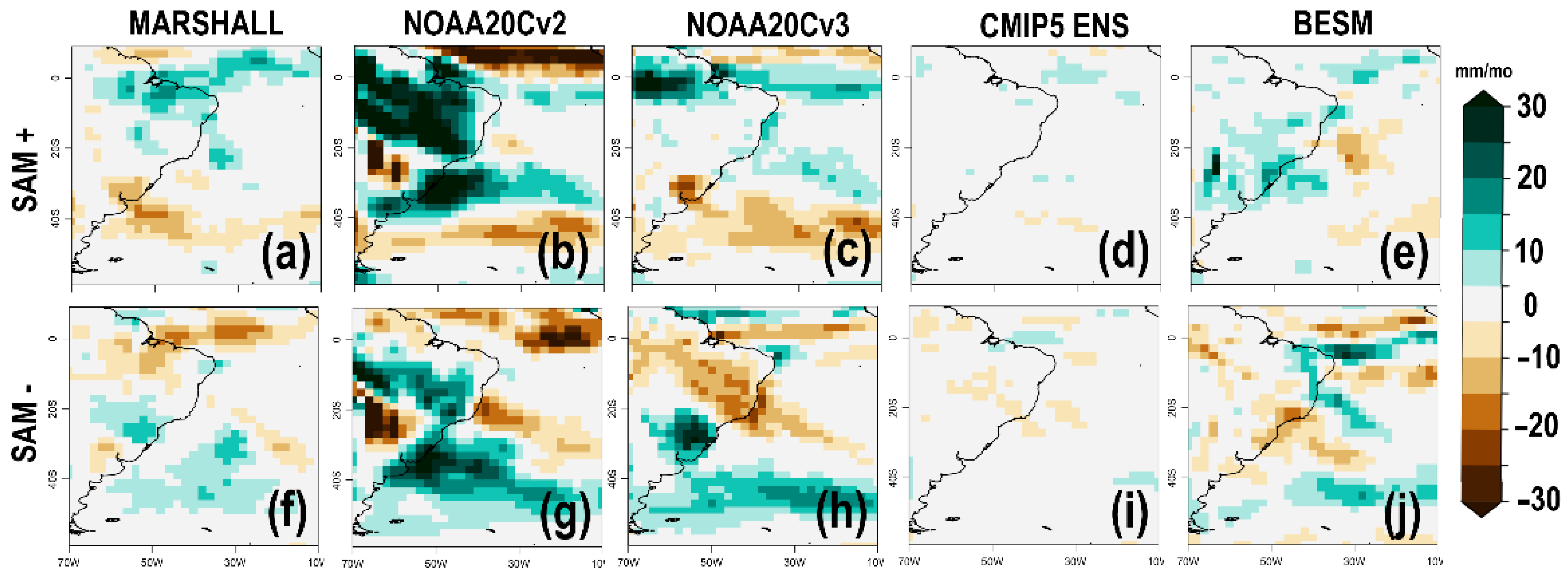
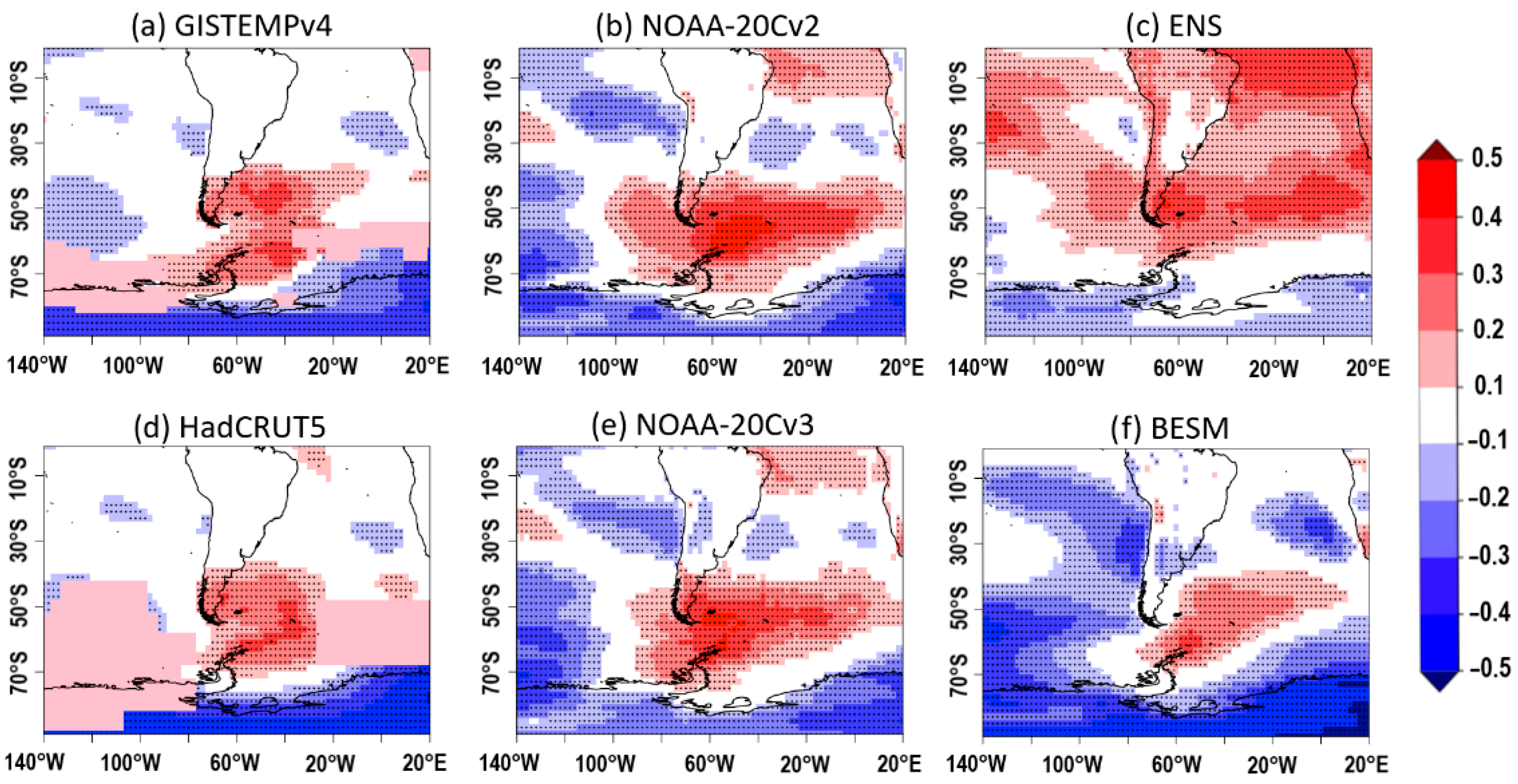
3. Results
4. Discussion and Conclusions
4.1. Precipitation
4.2. Surface Temperature
Supplementary Materials
Author Contributions
Funding
Data Availability Statement
Acknowledgments
Conflicts of Interest
References
- Rogers, J.C.; van Loon, H. Spatial variability of sea level pressure and 500 mb height anomalies over the Southern Hemisphere. Mon. Weather Rev. 1982, 110, 1375–1392. [Google Scholar] [CrossRef] [Green Version]
- Thompson, D.W.J.; Wallace, J.M. Annular modes in the extratropical circulation. Part I: Month-to-month variability. J. Clim. 2000, 13, 1000–1016. [Google Scholar] [CrossRef]
- Zheng, F.; Li, J.; Clark, R.T.; Nnamchi, H.C. Simulation and projection of the Southern Hemisphere annular mode in CMIP5 models. J. Clim. 2013, 26, 9860–9879. [Google Scholar] [CrossRef] [Green Version]
- Gong, D.; Wang, S. Definition of Antarctic oscillation index. Geophys. Res. Lett. 1999, 26, 459–462. [Google Scholar] [CrossRef] [Green Version]
- Fogt, R.L.; Marshall, G.J. The Southern Annular Mode: Variability, trends, and climate impacts across the Southern Hemisphere. WIREs Clim. Chang. 2020, 11, e652. [Google Scholar] [CrossRef]
- Trenberth, K.E.; Stepaniak, D.P.; Smith, L. Interannual variability of the patterns of atmospheric mass distribution. J. Clim. 2005, 18, 2812–2825. [Google Scholar] [CrossRef]
- Russell, A.; McGregor, G.R. Southern hemisphere atmospheric circulation: Impacts on Antarctic climate and reconstructions from Antarctic ice core data. Clim. Chang. 2010, 99, 155–195. [Google Scholar] [CrossRef] [Green Version]
- Ibebuchi, C.C. On the relationship between circulation patterns, the Southern Annular Mode, and rainfall variability in Western Cape. Atmosphere 2021, 12, 753. [Google Scholar] [CrossRef]
- Reboita, M.S.; Rocha, R.P.; Ambrizzi, T.; Gouveia, C.D. Trend and teleconnection patterns in the climatology of extratropical cyclones over the Southern Hemisphere. Clim. Dyn. 2015, 45, 1929–1944. [Google Scholar] [CrossRef]
- Gallego, D.; Ribera, P.; Garcia-Herrera, R.; Hernandez, E.; Gimeno, L. A new look for the Southern Hemisphere jet stream. Clim. Dyn. 2005, 24, 607–621. [Google Scholar] [CrossRef]
- L’Heureux, M.L.; Thompson, D.W.J. Observed relationships between the El Niño–Southern Oscillation and the extratropical zonal-mean circulation. J. Clim. 2006, 19, 276–287. [Google Scholar] [CrossRef]
- Vasconcellos, F.C.; Pizzochero, R.M.; Cavalcanti, I.F.A. Month-to-month impacts of Southern Annular Mode over South America climate. Anuário Inst. Geociências 2019, 42, 783–792. [Google Scholar] [CrossRef]
- Reboita, M.S.; Ambrizzi, T.; Rocha, R.P. Relationship between the Southern Annular Mode and Southern Hemisphere atmospheric systems. Rev. Bras. Meteorol. 2009, 24, 48–55. [Google Scholar] [CrossRef] [Green Version]
- McLandress, C.; Shepherd, T.G.; Scinocca, J.F.; Plummer, D.A.; Sigmond, M.; Jonsson, A.I.; Reader, M.C. Separating the dynamical effects of climate change and ozone depletion. Part II: Southern Hemisphere troposphere. J. Clim. 2011, 24, 1850–1868. [Google Scholar] [CrossRef] [Green Version]
- Gong, T.; Feldstein, S.B.; Luo, D. The impact of ENSO on wave breaking and Southern Annular Mode events. J. Atmos. Sci. 2010, 67, 2854–2870. [Google Scholar] [CrossRef] [Green Version]
- Thompson, D.W.J.; Solomon, S. Interpretation of recent Southern Hemisphere climate change. Science 2002, 296, 895–899. [Google Scholar] [CrossRef] [Green Version]
- Marshall, G.J. Trends in the Southern Annular Mode from observations and reanalyses. J. Clim. 2003, 16, 4134–4143. [Google Scholar] [CrossRef]
- Goodwin, I.D.; van Ommen, T.D.; Curran, M.A.J.; Mayewski, P.A. Mid latitude winter climate variability in the South Indian and southwest Pacific regions since 1300 AD. Clim. Dyn. 2004, 22, 783–794. [Google Scholar] [CrossRef]
- Taylor, K.E.; Stouffer, R.J.; Meehl, G.A. A Summary of the CMIP5 Experiment Design. 2009. Available online: https://pcmdi.llnl.gov/mips/cmip5/experiment_design.html (accessed on 17 August 2020).
- Nobre, P.; Siqueira, L.S.P.; De Almeida, R.A.F.; Malagutti, M.; Giarolla, E.; Castelão, G.P.; Bottino, M.J.; Kubota, P.; Figueroa, S.N.; Costa, M.C.; et al. Climate simulation and change in the brazilian climate model. J. Clim. 2013, 26, 6716–6732. [Google Scholar] [CrossRef]
- Giarolla, E.; Siqueira, L.S.P.; Bottino, M.J.; Malagutti, M.; Capistrano, V.B.; Nobre, P. Equatorial Atlantic Ocean dynamics in a coupled ocean atmosphere model simulation. Ocean Dynam. 2015, 65, 831–843. [Google Scholar] [CrossRef] [Green Version]
- Figueroa, S.N.; Bonatti, J.P.; Kubota, P.Y.; Grell, G.A.; Morrison, H.; Barros, S.R.M.; Fernandez, J.P.R.; Ramirez, E.; Capistrano, V.B.; Alvim, D.S.; et al. The Brazilian Global Atmospheric Model (BAM): Performance for Tropical Rainfall Forecasting and Sensitivity to Convective Scheme and Horizontal Resolution. Weather Forecast. 2016, 31, 1547–1572. [Google Scholar] [CrossRef]
- Prado, L.F.; Wainer, I.; de Souza, R.B. Positive SAM trend as seen in the Brazilian Earth System Model (BESM) future scenarios. Ann. Brazil. Acad. Sci. 2021, in press. [Google Scholar]
- Casagrande, F.; de Souza, R.B.; Nobre, P.; Marquez, A.L. An inter-hemispheric seasonal comparison of polar amplification using radiative forcing of a quadrupling CO2 experiment. Ann. Geophys. 2020, 38, 1123–1138. [Google Scholar] [CrossRef]
- Capistrano, V.B.; Nobre, P.; Veiga, S.F.; Tedeschi, R.; Silva, J.; Bottino, M.; Silva, M.B., Jr.; Menezes Neto, O.L.; Figueroa, S.N.; Bonatti, J.P.; et al. Assessing the performance of climate change simulation results from BESM-OA2.5 compared with a CMIP5 model ensemble. Geosci. Model Dev. 2020, 13, 2277–2296. [Google Scholar] [CrossRef]
- Griffies, S.M. Elements of MOM4p1. NOAA/Geophysical Fluid Dynamics Laboratory; Ocean Group Technical Report 6; 2009, 444p. Available online: https://www.gfdl.noaa.gov/wp-content/uploads/files/model_development/ocean/guide4p1.pdf (accessed on 11 August 2021).
- Winton, M. A reformulated three-layer sea ice model. J. Atmos. Ocean. Tech. 2000, 17, 525–531. [Google Scholar] [CrossRef] [Green Version]
- Taylor, K.E.; Stouffer, R.J.; Meehl, G.A. An overview of CMIP5 and the experiment design. Bull. Am. Meteorol. Soc. 2012, 93, 485–498. [Google Scholar] [CrossRef] [Green Version]
- Veiga, S.F.; Nobre, P.; Giarolla, E.; Capistrano, V.; Baptista Jr., M.; Marquez, A.L.; Figueroa, S.N.; Bonatti, J.P.; Kubota, P.; Nobre, C.A. The Brazilian Earth System Model ocean-atmosphere (BESM-OA) version 2.5: Evaluation of its CMIP5 historical simulation. Geosci. Model. Dev. 2019, 12, 1613–1642. [Google Scholar] [CrossRef] [Green Version]
- Jones, P.W. A User’s Guide for SCRIP: A Spherical Coordinate Remapping and Interpolation Package. Los Alamos National Laboratory 1998, 29p. Available online: https://www.researchgate.net/publication/258437800_A_User’s_Guide_for_SCRIP_A_Spherical_Coordinate_Remapping_and_Interpolation_Package_Version_14 (accessed on 11 August 2021).
- Bi, D.; Dix, M.; Marsland, S.; Hirst, T.; O’Farrell, S.; Uotila, P.; Sullivan, A.; Yan, H.; Kowalczyk, E.; Rashid, H.; et al. ACCESS: The Australian coupled climate model for IPCC AR5 and CMIP5. In Climate Change Beijing; Chinese Academy of Science: Beijing, China, 2012. [Google Scholar]
- Gent, P.R.; Danabasoglu, G.; Donner, L.J.; Holland, M.M.; Hunke, E.C.; Jayne, S.R.; Lawrence, D.M.; Neale, R.B.; Rasch, P.J.; Vertenstein, M.; et al. The Community Climate System Model version 4. J. Clim. 2011, 24, 4973–4991. [Google Scholar] [CrossRef]
- Voldoire, A.; Sanchez-Gomez, E.; Salas y Mélia, D.; Decharme, B.; Cassou, C.; Sénési, S.; Valcke, S.; Beau, I.; Alias, A.; Chevallier, M.; et al. The CNRM-CM5.1 global climate model: Description and basic evaluation. Clim. Dyn. 2013, 40, 2091–2121. [Google Scholar] [CrossRef] [Green Version]
- Bao, Q.; Lin, P.; Zhou, T.; Liu, Y.; Yu, Y.; Wu, G.; He, B.; He, J.; Li, L.; Li, J.; et al. The Flexible Global Ocean-Atmosphere-Land System model, spectral version 2: FGOALS-s2. Adv. Atmos. Sci. 2012, 30, 561–576. [Google Scholar] [CrossRef]
- Collins, M.; Tett, S.F.B.; Cooper, C. The internal climate variability of HadCM3, a version of the Hadley Centre Coupled Model without flux adjustments. Clim. Dyn. 2001, 17, 61–81. [Google Scholar] [CrossRef]
- Dufresne, J.-L.; Foujols, M.-A.; Denvil, S.; Caubel, A.; Marti, O.; Aumont, O.; Balkanski, Y.; Bekki, S.; Bellenger, H.; Benshila, R.; et al. Climate change projections using the IPSL-CM5 Earth system model: From CMIP3 to CMIP5. Clim. Dyn. 2013, 40, 2123–2165. [Google Scholar] [CrossRef]
- Yukimoto, S.; Adachi, Y.; Hosaka, M.; Sakami, T.; Yoshimura, H.; Hirabara, M.; Tanaka, T.Y.; Shindo, E.; Tsujino, H.; Deushi, M.; et al. A new global climate model of the meteorological research institute: MRI-CGCM3—model description and basic performance. J. Meteor. Soc. 2011, 90, 23–64. [Google Scholar] [CrossRef] [Green Version]
- Adler, R.F.; Sapiano, M.R.P.; Huffman, G.J.; Wang, J.-J.; Gu, G.; Bolvin, D.; Chiu, L.; Schneider, U.; Becker, A.; Nelkin, E.; et al. The Global Precipitation Climatology Project (GPCP) monthly analysis (new version 2.3) and a review of 2017 global precipitation. Atmosphere 2018, 9, 138. [Google Scholar] [CrossRef] [Green Version]
- Lenssen, N.; Schmidt, G.; Hansen, J.; Menne, M.; Persin, A.; Ruedy, R.; Zyss, D. Improvements in the GISTEMP uncertainty model. J. Geophys. Res. Atmos. 2019, 124, 6307–6326. [Google Scholar] [CrossRef]
- Morice, C.P.; Kennedy, J.J.; Rayner, N.A.; Winn, J.P.; Hogan, E.; Killick, R.E.; Dunn, R.J.H.; Osborn, T.J.; Jones, P.D.; Simpson, I.R. An updated assessment of near-surface temperature change from 1850: The HADCRUT5 dataset. J. Geophys. Res. 2021, 126, e2016JD032361. [Google Scholar] [CrossRef]
- Compo, G.P.; Whitaker, J.S.; Sardeshmukh, P.D.; Matsui, N.; Allan, R.J.; Yin, X.; Gleason, B.E.; Vose, R.S.; Rutledge, G.; Bessemouin, P.; et al. The Twentieth Century Reanalysis Project. Q. J. R. Meteorol. Soc. 2011, 137, 1–28. [Google Scholar] [CrossRef]
- Slivinski, L.C.; Compo, G.P.; Whitaker, J.S.; Sardeshmukh, P.D.; Giese, B.S.; McColl, C.; Allan, R.; Yin, X.; Vose, R.; Titchner, H.; et al. Towards a more reliable historical reanalysis: Improvements for version 3 of the Twentieth Century Reanalysis system. Q. J. R. Meteorol. Soc. 2019, 145, 2876–2908. [Google Scholar] [CrossRef] [Green Version]
- Limpasuvan, V.; Hartmann, D.L. Eddies and the annular modes of climate variability. Geophys. Res. Lett. 1999, 26, 3133–3136. [Google Scholar] [CrossRef] [Green Version]
- Hartmann, D.L.; Wallace, J.M.; Limpasuvan, V.; Thompson, D.W.J.; Holton, J.R. Can ozone depletion and global warming interact to produce rapid climate change? Proc. Natl. Acad. Sci. USA 2000, 97, 1412–1417. [Google Scholar] [CrossRef] [Green Version]
- Marshall, G.J.; Stott, P.A.; Turner, J.; Connolley, W.M.; King, J.C.; Lachlan-Cope, T.A. Causes of exceptional atmospheric circulation changes in the Southern Hemisphere. Geophys. Res. Lett. 2004, 31, L14205. [Google Scholar] [CrossRef]
- Giarolla, E.; Veiga, S.F.; Nobre, P.; Silva Jr., M. B.; Capistrano, V.B.; Callegare, A.O. Sea surface height trends in the Southern hemisphere oceans simulated by the Brazilian Earth System Model under RCP4.5 and RCP8.5 scenarios. J. South Hemisph. Earth. Sys. Sci. 2020, 70, 280–289. [Google Scholar]
- Hendon, H.H.; Lim, E.P.; Nguyen, H. Seasonal variations of subtropical precipitation associated with the Southern Annular Mode. J. Clim. 2014, 27, 3446–3460. [Google Scholar] [CrossRef]
- Gillet, N.P.; Kell, T.D.; Jones, P.D. Regional impacts of the Southern Annular Mode. Geophys. Res. Lett. 2006, 33, L23704. [Google Scholar] [CrossRef]
- Jones, M.E.; Bromwich, D.H.; Nicolas, J.P.; Carrasco, J.; Plavcová, E.; Zou, X.; Wang, S.-H. Sixty years of widespread warming in the Southern middle and high latitudes (1957–2016). J. Clim. 2019, 32, 6875–6898. [Google Scholar] [CrossRef] [Green Version]
- Silvestri, G.E.; Vera, C. Antarctic Oscillation signal on precipitation anomalies over southeastern South America. Geophys. Res. Lett. 2003, 30, 2115. [Google Scholar] [CrossRef] [Green Version]
- Vera, C.S.; Osman, M. Activity of the Southern Annular Mode during 2015–2016 El Niño event and its impact on Southern Hemisphere climate anomalies. Int. J. Climatol. 2018, 38, e1288–e1295. [Google Scholar] [CrossRef]
- Silvestri, G.; Vera, C. Nonstationary impacts of the Southern Annular Mode on Southern Hemisphere climate. J. Clim. 2009, 22, 6142–6148. [Google Scholar] [CrossRef]
- Carvalho, L.; Jones, C.; Ambrizzi, T. Opposite phases of the Antarctic Oscillation and relationships with intraseasonal to interannual activity in the tropics during the austral summer. J. Clim. 2005, 18, 702–718. [Google Scholar] [CrossRef] [Green Version]
- Kidson, J.W.; Sinclair, M.R. The influence of persistent anomalies on Southern Hemisphere storm tracks. J. Clim. 1995, 8, 1938–1950. [Google Scholar] [CrossRef] [Green Version]
- Schenzinger, V.; Osprey, S.M. Interpreting the nature of Northern and Southern Annular Mode variability in CMIP5 Models. J. Geophys. Res. Atmos. 2015, 120, 11,203–11,214. [Google Scholar] [CrossRef]
- van Lipzig, N.P.M.; Marshall, G.J.; Orr, A.; King, J.C. The relationship between the Southern Hemisphere annular mode and Antarctic peninsula summer temperatures: Analysis of a high-resolution model climatology. J. Clim. 2008, 21, 1649–1668. [Google Scholar] [CrossRef]
- Kwok, R.; Comiso, J.C. Spatial patterns of variability in Antarctic surface temperature: Connections to the Southern Hemisphere annular mode and the southern oscillation. Geophys. Res. Lett. 2002, 29, 50-1–50-4. [Google Scholar] [CrossRef] [Green Version]
- Marshall, G.J.; Bracegirdle, T.J. An examination of the relationship between the Southern Annular Mode and Antarctic surface air temperatures in the CMIP5 historical runs. Clim. Dyn. 2015, 45, 1513–1535. [Google Scholar] [CrossRef]


| Model | Institution | Grid |
|---|---|---|
| ACCESS1.0 [31] | Centre for Australian Weather and Climate Research (CAWCR) | 1.875 × 1.25 |
| BESM-OA2.5 [20] | Brazilian National Institute for Space Research (INPE) | 1.875 × 1.875 |
| CCSM4 [32] | National Center for Atmospheric Research (NCAR) | 1.25 × 0.9424 |
| CNRM-CM5 [33] | Centre National de Recherches Météorologiques/Centre Européen de Recherche et Formation Avancées en Calcul Scientifique (CNRM-CERFACS) | 1.40625 × 1.4008 |
| FGOALS-s2 [34] | Institute of Atmospheric Physics, Chinese Academy of Sciences (LASG-IAP) | 2.8125 × 1.6590 |
| GISS-E2-H | NASA Goddard Institute for Space Sciences (GISS) | 2.5 × 2 |
| HadCM3 2 [35] | Met Office Hadley Centre (MOHC) | 3.75 × 2.5 |
| IPSL-CM5A-LR [36] | Institute Pierre Simon Laplace (IPSL) | 3.75 × 1.8947 |
| MRI-CGCM3 [37] | Meteorological Research Institute (MRI) | 1.125 × 1.12148 |
Publisher’s Note: MDPI stays neutral with regard to jurisdictional claims in published maps and institutional affiliations. |
© 2021 by the authors. Licensee MDPI, Basel, Switzerland. This article is an open access article distributed under the terms and conditions of the Creative Commons Attribution (CC BY) license (https://creativecommons.org/licenses/by/4.0/).
Share and Cite
Prado, L.F.; Wainer, I.; de Souza, R.B. The Representation of the Southern Annular Mode Signal in the Brazilian Earth System Model. Atmosphere 2021, 12, 1045. https://doi.org/10.3390/atmos12081045
Prado LF, Wainer I, de Souza RB. The Representation of the Southern Annular Mode Signal in the Brazilian Earth System Model. Atmosphere. 2021; 12(8):1045. https://doi.org/10.3390/atmos12081045
Chicago/Turabian StylePrado, Luciana F., Ilana Wainer, and Ronald B. de Souza. 2021. "The Representation of the Southern Annular Mode Signal in the Brazilian Earth System Model" Atmosphere 12, no. 8: 1045. https://doi.org/10.3390/atmos12081045
APA StylePrado, L. F., Wainer, I., & de Souza, R. B. (2021). The Representation of the Southern Annular Mode Signal in the Brazilian Earth System Model. Atmosphere, 12(8), 1045. https://doi.org/10.3390/atmos12081045