Article

Fire Danger Harmonization Based on the Fire Weather Index for Transboundary Events between Portugal and Spain

1
Department of Mechanical Engineering, University of Coimbra, ADAI, Rua Luís Reis Santos, Pólo II, 3030-788 Coimbra, Portugal
2
Portuguese Institute for Sea and Atmosphere (IPMA), Rua C do Aeroporto, 1749-077 Lisboa, Portugal
3
State Meteorological Agency, (AEMET), 28071 Madrid, Spain
*
Author to whom correspondence should be addressed.
Atmosphere 2021, 12(9), 1087; https://doi.org/10.3390/atmos12091087 (registering DOI)
Submission received: 2 July 2021 / Revised: 19 August 2021 / Accepted: 21 August 2021 / Published: 24 August 2021
(This article belongs to the Special Issue Advances in Fire-Atmosphere Interaction)

Abstract

:
Portugal and Spain have a cross-border cooperation protocol on wildfires response for a buffer strip of 25 km for each side of the border. In spite of the success of this collaboration, there are issues to be improved, since Portuguese and Spanish authorities use different methodologies to assess the daily fire danger. A methodology to harmonize fire danger and its interpretation by the Portuguese and Spanish Civil protection authorities in the transboundary buffer strip area is hereby presented. The fire danger index used is the Canadian Fire Weather Index (FWI), which requires input from meteorological data and gives an indication of fire intensity. The fire danger class is an important decision support tool for preventing and fighting wildfires. Since the meaning of FWI values change from region-to-region according to its specific characteristics, a calibration process was performed based on statistical data of the daily FWI values, the number of fires and burned area between 2005 and 2013. The results of the FWI calibration and harmonization of the data for the five danger classes minimizes the fire danger discrepancies across the border. This methodology has the potential to be reproduced in other areas.

1. Introduction

Several systems in studying the more favorable conditions for wildfire occurrence and spread were developed, in order to anticipate the daily fire occurrence and behavior [1,2], which may be incorporated in decision support tools and transferred to operational decisions. These systems define a “Fire danger” index to support the management of fire prevention and fire suppression forces in each region. “Fire danger” is hereby defined as the potential for damage by fire in a certain area [3]. The intensity of wildfire danger is summarized by assessing the changes in the frequency of different classes of danger (from relatively low values of danger up to higher values linked with maximum fire danger) [4]. In some countries, the danger classes are not established with the same criteria and more than one system is used to estimate the fire danger, leaving the decision to users in adopting the most appropriate level of danger in each situation [5].
The Canadian Forest Fire Danger Rating System (CFFDRS) is the result of a research program conducted in Canada since 1968 [6] having as a main outcome the Canadian Forest Fire Weather Index System (CFFWIS) that was developed by Van Wagner in 1987 [7]. The CFFWIS produces the Fire Weather Index (FWI), which is a composite index that represents the meteorological conditions and gives an indication of the fire intensity [7]. Due to the few input data, which are required and the good performance presented, the FWI has been adopted in many countries and has been evaluated in several regions, for example the Canadian Boreal Forest [8], Tuscany in Italy, Thessaloniki, Athens and Heraklion in Greece [9] or the Daxing’anling in China [10]. Several proposals of other fire danger indexes [11,12] were made, but none achieving the wide recognition of FWI. Among five methods for the evaluation of fire danger in six Mediterranean regions tested by [1], FWI showed the best performance especially for the summer season. The FWI is only based on meteorological information, but we recognize that other factors (e.g., topography, vegetation cover, human activity, fire detection and suppression capacity) affect fire ignition and spread, and consequently the fire danger. For these reason, FWI should be calibrated.
The Canadian FWI system is being used by the national meteorological services to assess the fire danger in Portugal by the Portuguese Institute for Sea and Atmosphere (IPMA) since the decade of 1990 and in Spain by the Spanish State Meteorological Agency (AEMET) since 2008 [13,14]. In spite of the specific characteristics of each country, the FWI and its sub-indexes present good performance in assessing past fire events when related to the number of fire occurrences and the burned area [1,15,16]. The authors in [17] developed several regression models with good performance relating the monthly area burned and number of fires with the Canadian indexes for each Portuguese district, based on historical data. The authors in [16] showed good relationships between the FWI and the number of fires events for the Spanish province of Coruña and with the area burned for the Spanish province of Alicante [16]. While the authors in [17] developed daily fire occurrence models based on the Canadian fire danger indexes and on geographic factors organizing the country in 53 eco-regions, instead of the administrative division commonly followed.
The occurrence of transboundary fire events between Portugal and Spain is very frequent, sometimes requiring the intervention of civil protection forces from both countries. According to the data provided by the Portuguese Civil Protection and Emergency Authority (ANEPC), from 2012 to 2015, 134 international fire events (99 transboundary missions in Portugal and 35 transboundary missions in Spain), involving 1358 Portuguese and Spanish agents, occurred in the transboundary area between both countries [18]. A joint declaration [19] from the PT-ES ministers of internal affairs after the XXIV Luso-Spanish Summit in 2009, refers the establishment of a protocol for technical cooperation and mutual assistance in the field of civil protection. According to this agreement, both civil protection authorities are allowed to intervene in any wildfire occurring in the transboundary strip up to 25 km from each side of the international border without a previous notification of the authorities where the wildfire is occurring. Despite the importance of this agreement, no provisions were made to define a common methodology to assess fire danger conditions.
In order to illustrate the consequences of using different methodologies to assess the daily fire danger, Figure 1 presents as an example, the classification of the fire danger classes based on FWI, in Portugal and Spain in 12 June 2014. As shown in Figure 1 both countries currently have five fire danger classes using different color codes, from class 1 to class 5, they are usually named as Low, Moderate, High, Very high and Maximum, respectively.
When the international border is crossed, the discrepancies that are shown in Figure 1 arise due to the different methodologies that were used in Portugal and Spain to estimate the FWI values. As FWI is based on meteorological data obtained from weather stations, it must be recognized that each station represents the microclimate of the place where it is installed, which may not represent the average conditions in the region well. As a consequence, the value of FWI from a given station does not have the character of an absolute value but it must be considered as a relative value. This is an additional reason to perform the calibration of the FWI scale.
The Portuguese decision makers and first responders use data provided by IPMA and the corresponding Spanish agencies use data provided by AEMET or by regional meteorological services, each one using different fire danger classifications. This discrepancy in data and their interpretation hampers joint actions between the two countries, both in fire prevention and fire suppression activities. Therefore, the existence of common and shared information and a mutual interpretation of fire danger is essential for improving the efficiency of collaborative fire management operations, especially in the transboundary areas.
This study reports the results of a fire danger assessment harmonization based on the FWI calibration performed for the districts and provinces enclosed within the cooperative zone 25 km of each side of the international border. The objective of this study is the harmonization of the fire danger assessment to achieve a common fire danger to support fire management activities. The study was performed using the data of the main fire season of this region, typically from 1 June to 30 September, between 2005 to 2013 for Portugal and Spain. As a result, a table with FWI class limits for each of the five fire danger classes is proposed to be adopted in the respective regions.
Besides the specific interest of the calibration values found for the cross-border area between Portugal and Spain, this study presents great benefits given that it can be easily replicated in other regions of the globe.

2. Methodology

2.1. Study Area and Dataset

The calibration was performed considering the transboundary region between Portugal and Spain as shown in Figure 2. This figure also presents the available climatological weather stations in the study.
The map of Figure 2 presents the stations that existed in the considered period and those that were used to calculate the FWI.
There are some meteorological stations with missing meteorological data (gaps), since the FWI needs to be calculated without gaps, the stations outside 25 km were used to manage the missing data found in the 25 km study area. In Portugal, IPMA determines the missing data by interpolation to get a complete dataset. In Spain, AEMET use the R-package CLIMATOL [20] to determine the missing data. The stations outside the 25 km limits and which are marked on the map were used to replace gaps.
In Portugal, the territory was divided into districts while in Spain the territory was divided into provinces. Figure 3 presents this administrative organization in both countries for the study area of interest.
The area of interest is the strip with a width of 50 km (25 km for each side of the border). Given the different geopolitical characteristics of both countries, we chose to perform an analysis at district level for Portugal and at Province level for Spain, particularly due to the relevance of these administrative areas for fire management purposes. A second reason to choose this administrative division was the need for sufficient fire occurrence data to develop the proposed calibration process.
In many cases, Portuguese districts have a border with more than one Spanish province, and vice versa (Figure 3). This correspondence was considered, in order to have a common calibration for the adjacent Portuguese districts and Spanish provinces resulting in 14 “district–province pairs”. The calibration was limited to the transboundary strip. The calibration between two adjacent Spanish provinces or two adjacent Portuguese districts was not considered.
The dataset is composed by meteorological data and fire history. The temporal scale used in this study was for the main fire season considered from 1 June to 30 September, from 2005 to 2013. For the Spanish provinces of Huelva and Pontevedra the meteorological data were available only from 2006–2013.
As defined by [7], the FWI is calculated at 12:00 (local time), since in normal situations, it reflects the most adverse meteorological conditions for wildfires (temperature and relative humidity) during the day. The noon meteorological data from the weather stations of IPMA and AEMET were used to determine the historical daily values of FWI: (i) Air temperature, (ii) relative humidity, (iii) wind speed and (iv) rainfall. In the fire history of each region, the number of fires and the burned area in each day were considered.
FWI requires a prior calibration to take into account the specific properties of a region, in this study the FWI calibration is performed through the fire history data as proposed by [2]. The statistical data on wildfires in Portugal were obtained through [21] while the data for Spain were obtained through [22]. Table 1 presents the period of extension of the statistical dataset, and includes the daily average of number of fires (NF) and burned area (ha) for each region.
Table 1 clearly reflects the differences in the number of fires and burned area between Portugal and Spain. There are similarities in Portuguese districts of Viana do Castelo, Braga and Bragança with the Spanish province of Pontevedra. In the adjacent regions with Salamanca, Badajoz or Huelva the differences are quite large. The low values of fire occurrence (both NF, and BA) in some areas, like for example in Huelva, has implications for statistical evaluation.

2.2. Determination of the Daily Value of FWI

The daily FWI values were determined according to [7]. The study area is limited by a line 25 km apart from the border between both countries, but for the estimation of FWI weather stations, located in a buffer zone with a width of 35 km to each side of the border were adopted. We used the daily values of the meteorological parameters provided by the weather stations of the Portuguese districts and Spanish provinces to determine the FWI values for each transboundary region. For the regions without a weather station, the meteorological parameters provided by the two nearest weather stations were interpolated to determine the FWI values. Since the data were not available for all the identified stations in Spain, we selected those for which we had more data.
The weather stations used in Portugal and in Spain are listed in Table A1 and in Table A2, respectively.

2.3. Calibration

In order to calibrate and harmonize the FWI at the border between both countries we followed the methodology proposed in [2]. This study was published in 2004 being applied for Portugal with a dataset from 1988 and 1996 for the period between 15 May and 15 October [2]. The FWI calibration range values and classes presented in [2] for each Portuguese district were used for several years by IPMA [23]. The FWI calibration range values were re-determined by [24] using meteorological data from 2001 to 2012. The values and classes found in [24were very similar to those published by [2] indicating that the calibration method is quite robust and did not change much in the period of 15 years that Separated both sets of data.
Considering the required parameters defined in [2], we analyzed for each region the following data:
  • Daily FWI values
  • Daily number of fires (NF), and
  • Daily burned area (BA).
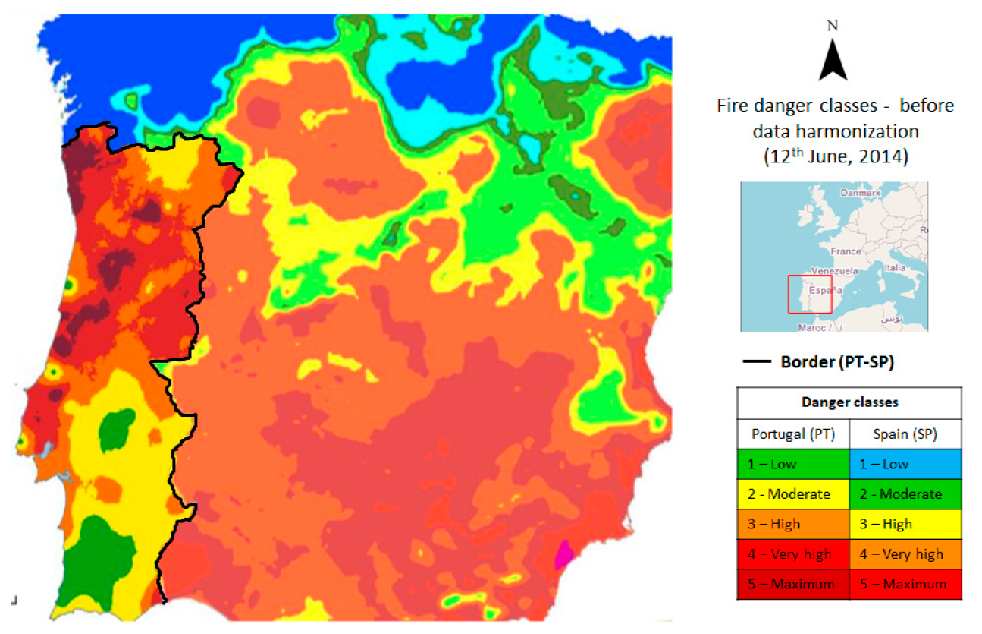
Maintaining the correspondence between all data, in each area it was rearranged by ordering the FWI in an ascending order. Afterwards, a numerical incremental field, named incremental day was included, with the value of “1” being attributed to the day with the lowest value of FWI, and consecutively adding “1” to the following data. So the last data is the “total number of days”. The probability (P) is calculated by dividing the Incremental day (dn) number by the total number of days (dTotal) as presented in Equation (1) This cumulative probability reflects the weight that a given day (and its respective FWI) has in respect to the total number of days:
P = Incremental   day   ( d n ) Incremental   day   total ( d Total )
The FWI values limiting each class of fire danger based on the occurrence probability of a given FWI daily value were established according to the probability or percentile values indicated in Table 2. The “probability” term and the “percentile” term have a similar meaning for us; we designate by percentile the group of values of FWI that have a given probability of occurrence that is indicated in the percentile value or class. For example, a percentile P40 refers to all values of FWI, NF, BA, which have a probability of occurrence equal to, or lower than, 0.4. We maintain the word “percentile” as it is a simpler way to refer to the group of values of the data set (FWI, NF, BA) that have a probability of occurrence corresponding to the respective percentile.
The initial classification is based on Table 2 of probability of occurrence values and then adjusted to the region of application. The limiting values of the classes of probability are arbitrary and they are established initially based on what is expected for an “average” or “normal” region.
To make the classification meaningful, for the final proposal we consider that no more than 5% of the days should be on the “maximum” or extreme class. In some regions we find that there are no more than 2 or 3% of days in the historical record that have outstanding extreme days, and the Maximum (Class 5) percentile threshold was changed accordingly. We also consider that, on average, 40% of the days in a fire season have a low risk, so we set the first class in this percentile; but in some regions, the number of days without fires or with very small fires can correspond to 50 or 60% of the total number of days. In those cases, we have to change the corresponding percentile and the limiting values of FWI. This is applicable to the other intermediate classes so these adjustments can be made with a wide range of discretion without breaking the proposed methodology.
In order to check the relevance of FWI to assess the fire danger in a given area both in terms of average values of NF and BA, the relationship between the two pairs of variables was performed: FWI and the number of fires (NF).
It is assumed that in each region in a sufficiently large period of time, there exists a regular and monotonic relationship between the average number of fires NF or of the burned area BA, and the value of FWI, expressed respectively by functions f1 (2) and f2 (3).
NF = f 1 ( FWI )
BA = f 2 ( FWI )
Functions f1 and f2 were analyzed for the pairs of Portuguese districts and Spanish provinces (see Figure 3, above). The pairs “Viana do Castelo-Pontevedra”, “Guarda-Salamanca” and “Faro-Huelva” are presented in Figure 4, Figure 5 and Figure 6, respectively. Figures for the remaining pairs are shown in Appendix B (Figure A1, Figure A2, Figure A3, Figure A4, Figure A5, Figure A6, Figure A7, Figure A8, Figure A9, Figure A10 and Figure A11).
In the Portuguese districts presented in the previous figures, the FWI increases with overall increase in number of fires and burned area, but in some Spanish Provinces a this behavior was not found. There are some adjacent regions that have similarities as there is a continuity of the landscape, land use, as well as the meteorological conditions reflected in the FWI, that it is the case of the pair of the Portuguese district of Viana do Castelo and the Spanish province of Pontevedra (Figure 4). In this pair, the number of fires and burned area (Table 1) is also similar which causes the same FWI variation in both regions.
The pair of District of Guarda and (Figure 5) show that for comparable values of FWI, the values of number of fires and burned area in Guarda are very different from those found in the Province of Salamanca. These differences are mostly due the different topography and land use between these regions. The Portuguese districts are characterized by rugged and mountainous territory elevation while Salamanca is flatter as can be seen in the elevation map of Figure 2. We believe that this geologic difference was crucial in the international border historical definition. The topography of each country is indirectly being used in the calibration through the NF and BA, since mountainous regions have associated higher number of fires and burned area.
Figure 6 presents the pair for the Portuguese district of Faro and the Spanish province of Huelva.
In the pair of “Faro-Huelva” the average number of daily fire events is larger in Huelva region, but the burned area is much larger in the Faro region. This may be due to different approaches that are followed by the different fire management strategies followed in Portugal and Spain, like the different policies and resources that are available for higher values of FWI. The small number of cases in the Spanish province of Huelva (Table 1) has implications for statistical evaluation. The non-monotonic behavior is more evident in the regions where the number of fire events and/or burned area have lower values such as in the southern areas.
The relationship between the number of fires and burned area with the FWI depends on the meteorological station used. For example, in Salamanca, depending on the meteorological station used, the relationship is different, but the burned area is the same. This fact can be interpreted as the ability of the FWI to describe local conditions, showing that it is a good indicator of the potential extension and intensity of a fire, since high values of burned area are associated with high values of FWI. Considering the analysis of all 14 pairs, we assume that, in general terms, the FWI is a good indicator of fire danger in all these regions in the period of analysis.
Since we proposed to determine the FWI threshold values for each pair of Portuguese district and Spanish province, according to the five danger classes adopted, the calibration results are presented in Section 3.

2.4. Harmonization

We started by calibrating the historical FWI values by assigning them a class using the methodology described previously. A comparison of the fire danger class for the same day and for two adjacent regions of Portugal and Spain was carried out. The percentile adjustments for the final proposal were made mainly in classes 1 and 5, but in some cases, the intermediate classes were also modified. The objective was to have the same number of days in a given class for both sides of the border. This is expressed by the percentiles that were very similar in each class for both sides of the border in the final proposal. It was found that there were cases whereby the proposed classification did not agree on both sides of the border, meaning that, on some days, the class value for Portugal was one value above or below the class value found on the Spanish side. Discrepancies of more than one class were not found in the initial calibration. To quantify these days, the following conditions were counted:
  • The number of days in which the fire danger class estimated in Portugal was one level lower than the fire danger class estimate in Spain, were labeled “−1”.
  • The number of days with perfect arrangement (no discrepancies were found), were labeled “0”.
  • The number of days in which the fire danger class estimated in Portugal was one level higher than the fire danger class estimate in Spain, were labeled “1”.
In order to reduce or even avoid the number of discrepancies, the initial threshold FWI values from one side or from both sides were changed. In the end, the same counting was performed.
Harmonization results are presented in the Section 3.

3. Results

3.1. Calibration

Table 3 presents the FWI calibration range values and classes considering the two- step process: (i) Initial proposal, and (ii) final proposal resulted from the calibration and harmonization step. The classes numbered from 1 to 5 correspond usually to the following names, respectively: Low, Moderate, High, Very high and Maximum.
The influence of local factors, such as orography, is very pronounced in the North of Portugal and Spain (see elevation map in Figure 2). This orography influences the FWI values for very close regions where the average meteorological conditions are similar. For example, in Viana Castelo the danger classes change if we take Pontevedra or Ourense, and the same occurs for the other cases. The FWI differences highlighted in Table 3 explain the need for harmonization.
In the final proposal, the FWI values for each pair were determined by the harmonization analysis. The “Fire danger classes—final proposal” (Table 3), is the main outcome from the study that can be adopted in wildfire management operations in the transboundary areas.
The percentile adjustments between “initial proposal” and “final proposal” were made mainly in “Class 1” and “Class 5” in order to reduce the percentage of days with low danger and avoiding the days with maximum danger (as mentioned in the calibration process). An example of the percentile’s adjustments is presented in Table 4 for the pair “Viana do Castelo—Pontevedra”.

3.2. Harmonization

In Table 5, the results of the harmonization exercise for each pair of areas are presented according to the percentile and considering in the initial proposal and the percentile adjustments considering for the final proposal.
The column “Days” presents the number of days with weather data available and that it was considered suitable for calculating the FWI. For example, in years where the data were available up to a certain day, for example 20 September, we used the data until that day, since we reached a number of days without gaps acceptable for FWI calculation and for the analysis of the pair. Similar situations have occurred for the pairs resulting for each one in a particular number of days for analysis.
Considering the differences in the initial proposal, the FWI threshold values were adjusted for each pair. In the final proposal, the number of cases in the “0” column significantly increased. Along with the harmonization performed in the second step, (Table 5) the number of days classified as “−1” was 85 and those classified as “1” was 73 making a total of 158 days with a minor discrepancy of one value in the class. Considering that the total number of days considered in the analysis was 9866, in less than 1.60% of the days the harmonization did not work. This percentage was quite reduced from the 6.37% of the initial proposal. We consider that this is acceptable for practical applications.

4. Discussion

To achieve a common methodology and minimize the discrepancies found in the application of different methodologies by the national meteorological services, we performed a calibration and harmonization of the data based on the FWI, number of fires and burned area. According to the final proposal of Table 3, Figure 7 presents the result of the study for the buffer strip of about 50 km (25 km for each side) on the 12 June 2014.
Comparing with the figure before the data harmonization (Figure 1) for the same day, in Figure 7 the fire danger classes are more harmonized, making the border operations easier since they should use the same interpretation of the fire danger information.
As a representative example Figure 8 presents the FWI calibration range values for the class “Very high” (level 4), for the all pairs of Portuguese districts and Spanish provinces, under analysis. The values come from the final proposal for the fire danger (Table 3). The figures for the classes “Low” (level 1), “Moderate” (level 2) and “High” (level 3) are presented in Appendix C. The FWI calibration range values for class “Maximum” (level 5) are any value above those presented for class “Very high”, for this reason the figure for class “Maximum” is not presented.
From North to South, the limiting values of the FWI classes change, having usually higher values in the Southern regions. If we analyze the fire activity through the cross-border (see Table 1) we verify that the number of occurrences and burned areas are higher in the North, which explains the reason why the FWI threshold values are lower in southern regions. Northern regions are more prone to wildfire occurrences so a lower FWI value is indicative of conditions more favorable for wildfires in comparison with more Southern regions. This situation reinforces the need of the FWI calibration based on number of fires and burned area.
From the Portuguese to the Spanish side, we can see that after the data harmonization the threshold FWI value is commonly similar on both sides of the border, however there are still certain regions where the threshold FWI value changes abruptly when the border is crossed as is the case of Ourense. The Spanish province of Ourense presents low values of FWI in comparison to neighboring regions because the Ourense weather station represents local conditions (mountain or valley stations) and do not represent wider areas of the region. Another case is the pair “Guarda—Salamanca”, the Portuguese district of Guarda that has low values of threshold FWI value when it is compared to the Spanish province of Salamanca. Guarda has much higher fire activity (see Table 1) and it is also more mountainous than Salamanca (see elevation on Figure 2), which can explain the differences.
Although two adjacent regions have usually similar meteorological conditions, in this calibration we consider other factors, such as cultural habits in the use of fire and the organization of fire management agencies and policies that contribute to the differences on the limit values of the FWI. In general, the number of fires in the Portuguese Districts is higher than in the Spanish Provinces, which means that, in order to have a high fire danger level in Spain, a much higher FWI value is needed than in Portugal.
Some factors that affect the danger level and also have a great relevance in the number of fires and burned area are the specific topography of each country, structural aspects, firefighting response capacity or cultural differences like the use of fire that may produce several ignitions. These factors are considered indirectly in the proposed methodology of calibration, since the FWI was calibrated with the number of fires and burned area that consider the historical role of those factors. For similar weather conditions, in both countries, the FWI value may the same but the fire danger interpretation is different.

5. Conclusions

The application of the Canadian Forest Fire Weather Index System, which produces the FWI to assess the fire danger requires a prior calibration to consider the specific characteristics of a region. The proposed calibration methodology results in a range of FWI values associated with fire danger classes applied to each region. Therefore, the fire danger in a given region can be determined by calculating the meteorological index FWI, thereby avoiding the calculation of other conjunctural or combined indexes, which are more complex and require more input data.
In this study, a methodology for calibration and harmonization of the FWI to define the fire danger classes between border regions of Portugal and Spain was developed and applied to adjacent administrative areas (Portuguese districts and Spanish provinces) of each country.
The methodology is based on statistical data of about nine years of data on FWI, daily number of fires and burned area for the period between June and September, between 2005 and 2013.
Predefined values of probability of occurrence of FWI values in each region were used and five danger classes were defined (Low, Moderate, High, Very high and Maximum). The threshold FWI values for each class were determined resulting on an initial proposal for the fire danger classes. The existence of discrepancies in the estimated fire danger classes for neighboring areas in a number of days was observed. In a second step, the threshold FWI values were adjusted in order to harmonize the estimation of fire danger and reduce the number of discrepancies to less than 1.6% of the days. As a result, threshold values of FWI to define the fire danger classes for each Portuguese district and Spanish province were proposed to harmonize the assessment in the transboundary area. This outcome corresponds to the final proposal for the FWI calibration range values and classes.
The relationship of the FWI with number of fires and burned area for all the study regions verified that it is a good indicator of the potential extension and intensity of a wildfire.
This methodology can be applied to other transboundary areas, national or international as the dataset, including the FWI values, the number of fires and the area burned are available.
In future work we suggest undertaking the following: (i) Reproduce the methodology for a larger dataset and analyze how the FWI threshold values were changed; (ii) validate the methodology for the most recent years, (iii) analyze other methods of weather data interpolation; (iv) a detailed analysis about the factors that cause the discrepancies (determined in harmonization process) in neighbor’s regions on the border; and (v) study the recent cases of wildfires in the border.

Author Contributions

Conceptualization, D.A., M.A., D.X.V., I.N., M.Y.L.; methodology, D.A., M.A., D.X.V., I.N., M.Y.L.; resources, I.N., M.Y.L.; writing—original draft: D.A., M.A., D.X.V., I.N., M.Y.L.; writing—review & editing: D.A., M.A., D.X.V., I.N., M.Y.L.; supervision, D.X.V. All authors have read and agreed to the published version of the manuscript.

Funding

This research was funded by the research project supported by the Portuguese Science and Technology Foundation-FCT: “FireStorm: Meteorology and fire storm behavior” under the reference PCIF/GFC/0109/2017.

Acknowledgments

The Authors wish to acknowledge to European Commission for the support given to project “SpitFire: Spanish-Portuguese Meteorological Information System for Trans-Boundary Operations in Forest Fires” under the agreement number ECHO/SUB/2014/693768. The contribution provided by the following research projects supported by the Portuguese Science and Technology Foundation-FCT is also acknowledged: “MCFire: Measuring the moisture content of forest fuels and assessing their behaviour within the new climate realities” under the reference PCIF/MPG/0108/2017, and “SmokeStorm: “Forecasting and communicating wildland fire smoke effects” under the reference PCIF/MPG/0147/2019. The authors would like to express their gratitude to the SpitFire Colleagues from ADAI, IPMA, AEMET and ANEPC. Daniela Alves would like to thank the project Centro 2020 for its contract with the reference Centro-04-3559-FSE-000144.

Conflicts of Interest

The authors declare no conflict of interest.

Appendix A

Table A1. Portuguese weather stations used. The code and the meteo station designations are those used by IPMA.
DistrictCodeWeather Station
Viana do Castelo551Viana do Castelo
606Melgaço (Lam. Mouro)
605Monção
615Ponte de Lima
604Vila Nova de Cerveira
Braga622Braga
630Cabeceiras de Basto
Vila Real616Chaves
611Montalegre
Bragança575Bragança
635Miranda do Douro
637Mogadouro
800Torres de Moncorvo (Sabugal)
Guarda671Almeida (F.C. Rodrigo)
683Guarda
Castelo Branco570Castelo Branco
803Idanha-a-Nova
806Proença-a-Nova
Portalegre571Portalegre
835Elvas
Évora837Estremoz
558Évora
Beja562Beja
863Mértola
850Moura
Faro867Castro Marim
Table A2. Spanish weather stations used. The code and the meteo station designations are those used by AEMET.
ProvinceCodeWeather Station
Pontevedra1495Vigo Peinador
Ourense1700XCarballiño O.
Zamora2775XVillar de Ciervos
Salamanca2916AVitigudino
Cáceres3536XHoyos
Badajoz4452Badajoz/Talavera Real
Huelva4554XCartaya (Pemares)

Appendix B

Figure A1. Average number of daily fires (NF) and burned area (BA) as a function of FWI for: (a) the Portuguese District of Viana do Castelo and (b) the Spanish Province of Ourense.
Atmosphere 12 01087 g0a1
Figure A2. Average number of daily fires (NF) and burned area (BA) as a function of FWI for: (a) the Portuguese District of Braga and (b) the Spanish Province of Ourense.
Atmosphere 12 01087 g0a2
Figure A3. Average number of daily fires (NF) and burned area (BA) as a function of FWI for: (a) the Portuguese District of Vila Real and (b) the Spanish Province of Ourense.
Atmosphere 12 01087 g0a3
Figure A4. Average number of daily fires (NF) and burned area (BA) as a function of FWI for: (a) the Portuguese District of Bragança and (b) the Spanish Province of Ourense.
Atmosphere 12 01087 g0a4
Figure A5. Average number of daily fires (NF) and burned area (BA) as a function of FWI for: (a) the Portuguese District of Bragança and (b) the Spanish Province of Salamanca.
Atmosphere 12 01087 g0a5
Figure A6. Average number of daily fires (NF) and burned area (BA) as a function of FWI for: (a) the Portuguese District of Bragança and (b) the Spanish Province of Zamora.
Atmosphere 12 01087 g0a6
Figure A7. Average number of daily fires (NF) and burned area (BA) as a function of FWI for: (a) the Portuguese District of Castelo Branco and (b) the Spanish Province of Cáceres.
Atmosphere 12 01087 g0a7
Figure A8. Average number of daily fires (NF) and burned area (BA) as a function of FWI for: (a) the Portuguese District of Portalegre and (b) the Spanish Province of Cáceres.
Atmosphere 12 01087 g0a8
Figure A9. Average number of daily fires (NF) and burned area (BA) as a function of FWI for: (a) the Portuguese District of Portalegre and (b) the Spanish Province of Badajoz.
Atmosphere 12 01087 g0a9
Figure A10. Average number of daily fires (NF) and burned area (BA) as a function of FWI for: (a) the Portuguese District of Évora and (b) the Spanish Province of Badajoz.
Atmosphere 12 01087 g0a10
Figure A11. Average number of daily fires (NF) and burned area (BA) as a function of FWI for: (a) the Portuguese District of Beja and (b) the Spanish Province of Huelva.
Atmosphere 12 01087 g0a11

Appendix C

Figure A12. Final proposal of the threshold FWI values for each pair of District in Portugal (PT) and Province and Spain (SP)—Class “Low” (Level 1 of 5).
Atmosphere 12 01087 g0a12
Figure A13. Final proposal of the threshold FWI values for each pair of District in Portugal (PT) and Province and Spain (SP)—Class “Moderate” (Level 2 of 5).
Atmosphere 12 01087 g0a13
Figure A14. Final proposal of the threshold FWI values for each pair of District in Portugal (PT) and Province and Spain (SP)—Class 3 of 5 danger classes.
Atmosphere 12 01087 g0a14

References

  1. Viegas, D.X.; Bovio, G.; Ferreira, A.; Nosenzo, A.; Sol, B. Comparative study of various methods of fire danger evaluation in southern Europe. Int. J. Wildland Fire 1999, 9, 235–246. [Google Scholar] [CrossRef]
  2. Viegas, D.X.; Reis, R.M.; Cruz, M.G.; Viegas, M.T. Calibração do sistema Canadiano de Perigo de Incêndio para apli-cação em Portugal. Silva Lusit. 2004, 12, 77–94. (In Portuguese) [Google Scholar]
  3. Countryman, C.M. Rating fire danger by the multiple basic index system. J. For. 1966, 64, 531–536. [Google Scholar]
  4. Costa, H.; de Rigo, D.; Libertà, G.; Houston Durrant, T.; San-Miguel-Ayanz, J. European Wildfire Danger and Vulnerability in a Changing Climate: Towards Integrating Risk Dimensions, EUR 30116 EN; Publications Office of the European Union: Luxembourg, 2020; ISBN 978-92-76-16898-0. [Google Scholar] [CrossRef]
  5. Viegas, D.X.; Rossa, C.; Ribeiro, L.M. Incêndios Florestais; Verlag Dashofer: Lisboa, Portugal, 2011. [Google Scholar]
  6. Stocks, B.J.; Lynham, T.J.; Lawson, B.D.; Alexander, M.E.; Van Wagner, C.E.; McAlpine, R.S.; Dubé, D.E. Canadian Forest Fire Danger Rating System: An Overview. For. Chron. 1989, 65, 258–265. [Google Scholar] [CrossRef] [Green Version]
  7. Van Wagner, C.E. Development and Structure of the Canadian Forest Fire Weather Index System; Ontario Forestry Technical Report 1987; Government of Canada, Canadian Forestry Service: Ottawa, ON, Canada, 1987; 37p.
  8. Amiro, B.D.; Logan, K.A.; Wotton, B.M.; Flannigan, M.; Todd, J.B.; Stocks, B.J.; Martell, D.L. Fire weather index system components for large fires in the Canadian boreal forest. Int. J. Wildland Fire 2004, 13, 391–400. [Google Scholar] [CrossRef]
  9. Good, P.; Moriondo, M.; Giannakopoulos, C.; Bindi, M. The meteorological conditions associated with extreme fire risk in Italy and Greece: Relevance to climate model studies. Int. J. Wildland Fire 2008, 17, 155–165. [Google Scholar] [CrossRef]
  10. Tian, X.; McRae, D.J.; Jin, J.; Shu, L.; Zhao, F.; Wang, M. Wildfires and the Canadian Forest Fire Weather Index system for the Daxing’anling region of China. Int. J. Wildland Fire 2011, 20, 963–973. [Google Scholar] [CrossRef]
  11. Carrega, P. A Meteorological Index of Forest Fire Hazard in Mediterranean France. Int. J. Wildland Fire 1991, 1, 79–86. [Google Scholar] [CrossRef]
  12. De Vicente, J.; Crespo, F. A new wildland fire danger index for a Mediterranean region and some validation aspects. Int. J. Wildland Fire 2012, 21, 1030–1041. [Google Scholar] [CrossRef] [Green Version]
  13. Mestre, A.; Allue, M.; Peral, C.; Santamaría, R.; Lazcano, M. Operational Fire Danger System in Spain. In Proceedings of the International Workshop on Advances in Operational Weather Systems for Fire Danger Rating, Edmonton, AB, Canada, 14–16 July 2008. [Google Scholar]
  14. Romero, R.; Mestre, B.A.; Botey, M.R. Nueva Calibración para el Índice de Incendios en AEMET. XXXIII Jornadas Científicas de la Asociación Meteorológica Española. 2014. Available online: http://hdl.handle.net/20.500.11765/6039 (accessed on 17 April 2021).
  15. Carvalho, A.; Flannigan, M.; Logan, K.; Miranda, A.; Borrego, C. Fire activity in Portugal and its relationship to weather and the Canadian Fire Weather Index System. Int. J. Wildland Fire 2008, 17, 328–338. [Google Scholar] [CrossRef]
  16. Mestre, A.; Manta, M.I. A fire weather index as a basis for an early warning system in Spain. Int. J. Wildland Fire 2014, 23, 510–519. [Google Scholar] [CrossRef]
  17. Padilla, M.; Vega-García, C. On the comparative importance of fire danger rating indices and their integration with spatial and temporal variables for predicting daily human-caused fire occurrences in Spain. Int. J. Wildland Fire 2011, 20, 46–58. [Google Scholar] [CrossRef]
  18. Martins, M. 1st SpitFire Workshop: Operational Pt. Autoridade Nacional de Emergência e Proteção Civil, Lisboa. 2015. Available online: https://firehelp.wixsite.com/spitfire/events (accessed on 18 August 2021).
  19. MAI—Ministério da Administração Interna. Declaração de Zamora—Declaração Conjunta do Ministro da Administração Interna de Portugal e do Ministro do Interior de Espanha. XXIV Luso-Spanish Summit in Zamora. 2009. Available online: https://dre.pt/pesquisa/-/search/623041/details/maximized (accessed on 17 April 2021). (In Portuguese)
  20. Guijarro, J.A. Homogenization of Climatic Series with Climatol. 2018. Available online: https://core.ac.uk/download/pdf/326491514.pdf (accessed on 25 July 2021).
  21. Instituto da Conservação da Natureza e das Florestas. Estatísticas. 2016. Available online: http://www2.icnf.pt/portal/florestas/dfci/inc/estat-sgif (accessed on 17 April 2021).
  22. Gobierno de España. Catálogo de Metadatos. 2021. Available online: https://www.mapama.gob.es/ide/metadatos/ (accessed on 17 April 2021).
  23. Viegas, D.X.; Almeida, M.; Ribeiro, L.M. OComplexo de Incêndios de Pedrógão Grande e Concelhos Limítrofes, Iniciado a 17 de Junho de 2017. ADAI-CEIF, Coimbra. 2017. Available online: https://www.portugal.gov.pt/download-ficheiros/ficheiro.aspx?v=3bb9773b-59fb-4099-9de5-a22fdcad1e3b (accessed on 17 April 2021).
  24. Rocha, C.F. Validação do Índice de Risco de Incêndio Florestal—ICRIF. Master Thesis, University of Coimbra, Coimbra, Portugal, 2014. [Google Scholar]
Figure 1. Classification of the fire danger classes based on FWI in Portugal (PT) and Spain (SP) in 12 June 2014. The black line represents the border between PT and SP.
Atmosphere 12 01087 g001
Figure 2. Area of interest (25 km for each side of the transboundary strip between Portugal and Spain) and available climatological weather stations.
Atmosphere 12 01087 g002
Figure 3. Administrative organization in the study area for Portugal (PT) and Spain (SP). The green area represents the Portuguese districts, and the red area represents the Spanish provinces.
Atmosphere 12 01087 g003
Figure 4. Average number of daily fires (NF) and burned area (BA) as a function of FWI for: (a) Portuguese district of Viana do Castelo; and (b) the Spanish province of Pontevedra.
Atmosphere 12 01087 g004
Figure 5. Average number of daily fires (NF) and burned area (BA) as a function of FWI for: (a) Portuguese district of Guarda; and (b) Spanish province of Salamanca.
Atmosphere 12 01087 g005
Figure 6. Average number of daily fires (NF) and burned area (BA) as a function of FWI for: (a) Portuguese district of Faro; and (b) the Spanish province of Huelva.
Atmosphere 12 01087 g006
Figure 7. Classification of the danger level based on FWI in the transboundary area between Portugal (PT) and Spain (SP) in 12 June 2014—after data harmonization. The black line represents the border between PT and SP.
Atmosphere 12 01087 g007
Figure 8. Final proposal of the threshold FWI values for each pair of District in Portugal (PT) and Province and Spain (SP)—Class “Very high” (Level 4 of 5).
Atmosphere 12 01087 g008
Table 1. Temporal scale and daily average number of fires (NF) and burned area (BA) in the study regions.
District (PT) or Province (SP)SeasonPeriodDaily Average
NFBA (ha)
Viana do Castelo (PT)Jun.–Sep.2005–20135.429.1
Pontevedra (SP)Jun.–Sep.2006–20135.326.2
Ourense (SP)Jun.–Sep.2005–20132.614.2
Braga (PT)Jun.–Sep.2005–20138.927.2
Vila Real (PT)Jun.–Sep.2005–20135.538.5
Bragança (PT)Jun.–Sep.2005–20132.625.4
Zamora (SP)Jun.–Sep.2005–20130.66.5
Salamanca (SP)Jun.–Sep.2005–20130.22.2
Guarda (PT)Jun.–Sep.2005–20133.639.4
Castelo Branco (PT)Jun.–Sep.2005–20132.011.7
Caceres (SP)Jun.–Sep.2005–20130.57.4
Portalegre (PT)Jun.–Sep.2005–20131.23.4
Badajoz (SP)Jun.–Sep.2005–20130.31.7
Évora (PT)Jun.–Sep.2005–20131.44.1
Beja (PT)Jun.–Sep.2005–20131.35.3
Huelva (SP)Jun.–Sep.2006–20130.32.7
Faro (PT)Jun.–Sep.2005–20131.89.4
Table 2. Percentile values of FWI used for the initial proposal.
Fire Danger ClassPercentile Values
1—Low 0 FWI < P 40
2—Moderate P 40 FWI < P 60
3—High P 60 FWI < P 80
4—Very High P 80 FWI < P 95
5—Maximum FW P 95
Table 3. FWI values that limit the fire danger classes according to the initial and final proposal. Classes names: 1—Low, 2—Moderate, 3—High, 4—Very high, and 5—Maximum.
District (PT)
Province (SP)
Fire Danger Classes—Initial ProposalFire Danger Classes—Final Proposal *
1234512345
Viana do Castelo
Pontevedra
<28
<12
36
17
43
22
53
35
>53
>35
<24
<10
36
17
42
22
61
42
>61
>42
Viana do Castelo
Ourense
<16
<2
20
4
27
6
37
10
>37
>10
<15
<2
22
4
27
6
36
10
>36
>10
Braga
Ourense
<21
<2
27
4
33
6
43
10
>43
>10
<21
<2
28
4
33
6
47
13
>47
>13
Vila Real
Ourense
<22
<2
28
4
33
6
42
10
>42
>10
<22
<2
29
4
34
6
45
12
>45
>12
Bragança
Ourense
<32
<1
41
3
45
4
55
6
>55
>6
<35
<2
43
4
51
6
58
7
>58
>7
Bragança
Zamora
<35
<31
41
37
46
44
56
55
>56
>55
<32
<27
40
36
48
46
56
55
>56
>55
Bragança
Salamanca
<33
<40
39
48
45 5755
71
>55
>71
<33
<40
39
48
45
57
55
71
>55
>71
Guarda
Salamanca
<30
<40
37
48
43
57
54
71
>54
>71
<18
<30
37
48
46
61
57
74
>57
>74
Castelo Branco
Caceres
<35
<34
42
38
48
43
57
50
>57
>50
<20
<25
40
37
48
43
71
58
>71
>58
Portalegre
Cáceres
<37
<34
43
38
50
43
58
50
>58
>50
<37
<34
43
38
50
43
58
50
>58
>50
Portalegre
Badajoz
<36
<33
42
37
48
43
56
53
>56
>53
<30
<28
43
38
48
43
58
54
>58
>54
Évora
Badajoz
<36
<33
42
37
49
43
59
53
>59
>53
<32
<29
44
38
50
44
60
53
>60
>53
Beja
Huelva
<38
<30
43
36
48
43
56
54
>56
>54
<23
<19
35
28
48
43
59
60
>59
>60
Faro
Huelva
<39
<30
45
36
52
43
68
54
>68
>54
<33
<26
44
34
55
45
69
54
>69
>54
* Values determined after the percentile’s adjustments.
Table 4. FWI values and Percentile’s that limit the fire danger classes according to the initial and final proposal for the pair “Viana do Castelo—Pontevedra”. Classes names: 1—Low, 2—Moderate, 3—High, 4—Very high, and 5—Maximum.
District (PT)
Province (SP)
Initial ProposalFinal Proposal
Classes1234512345
Viana do Castelo (PT)FWI<28364353>53<24364261>61
Percentile<40608095>95<30607898>98
Pontevedra (SP)FWI<12172235>35<10172242>42
Percentile<40608095>95<30608098>98
Table 5. Number of days in which the fire danger class estimated in Portugal was one level lower than the class estimated in Spain (−1), number of days with perfect agreement (0), and number of days in which the fire danger class estimated in Portugal was one level lower than the class estimated in Spain (1).
Districts (PT)—Provinces (SP)DaysDifferences
InitialFinal
−101−101
Viana do Castelo—Pontevedra64638604486344
Viana do Castelo—Ourense8812877875286118
Braga—Ourense8825681412298530
Vila Real—Ourense8811381355158588
Bragança—Ourense7741686060117549
Bragança—Zamora59414573715903
Bragança—Salamanca7741765817658
Guarda—Salamanca77407443007695
Castelo Branco—Cáceres800117781107937
Portalegre—Cáceres8000793707937
Portalegre—Badajoz682266020126682
Évora—Badajoz68236334666742
Beja—Huelva3491339903390
Faro—Huelva3470338903470
Publisher’s Note: MDPI stays neutral with regard to jurisdictional claims in published maps and institutional affiliations.

