
Assessing the Impact of Natural Conditions/Socioeconomic Indicators on the Urban Thermal Environment Based on Geographic Big Data
Abstract
:1. Introduction
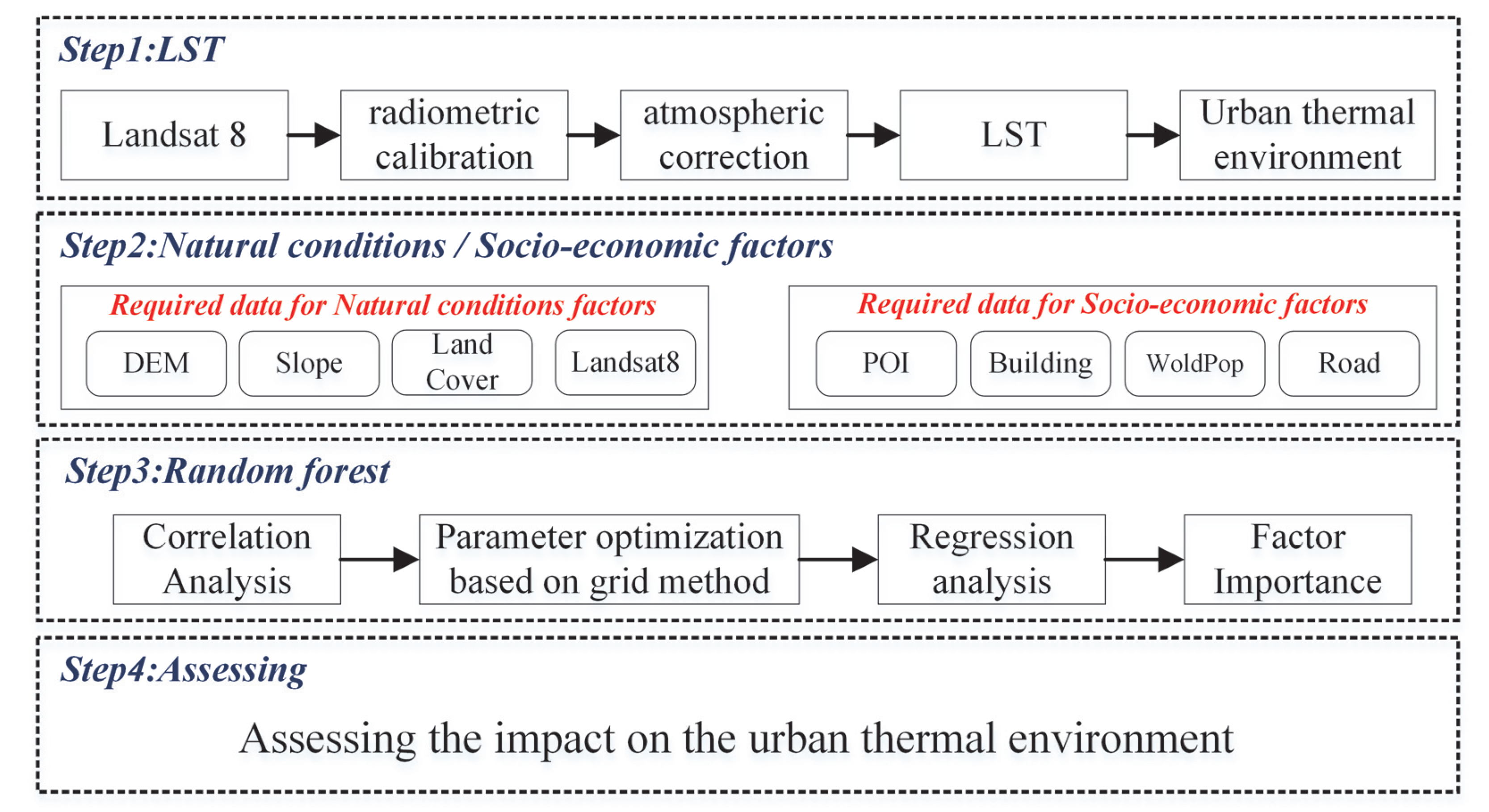
2. Methodology
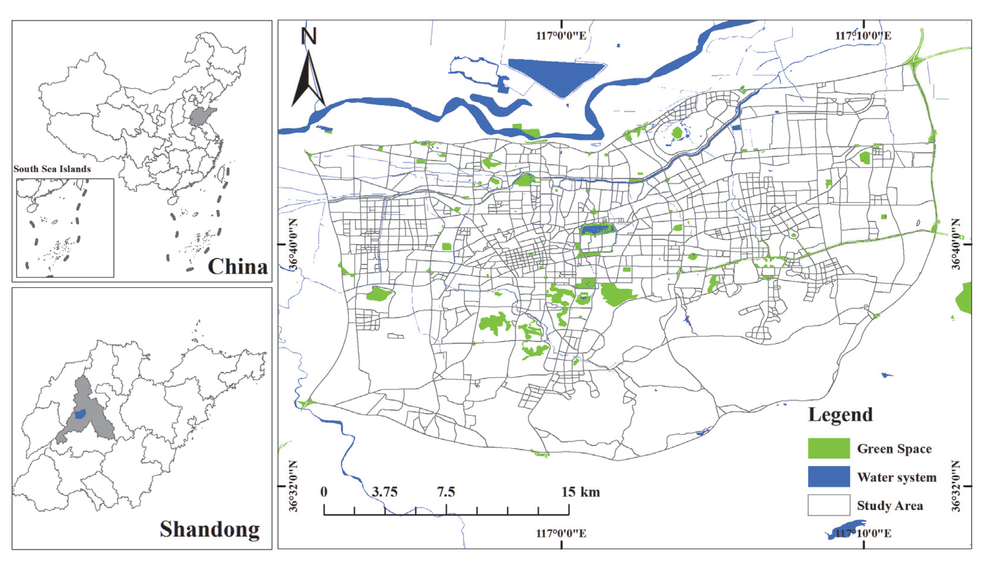
2.1. Study Area and Data
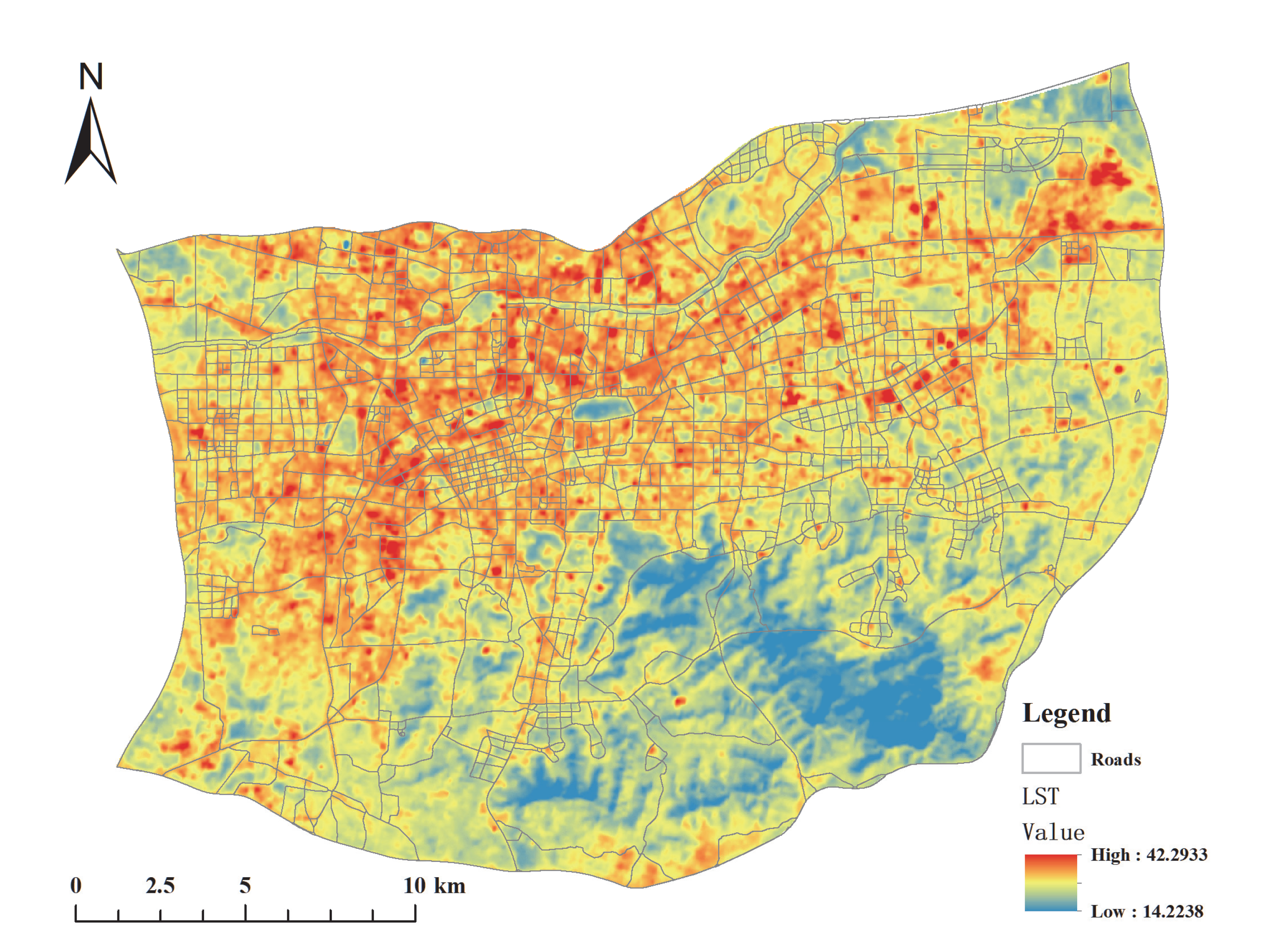
2.2. Retrieval of Land Surface Temperature
2.3. Assessment of Impact Factors Based on the RF Model
2.3.1. Measurement of Natural Conditions/Socioeconomic Factors
2.3.2. Factor Assessment Based on the Random Forest Model
3. Results
3.1. Land Surface Temperature Retrieval and SUHI Area Identification Results
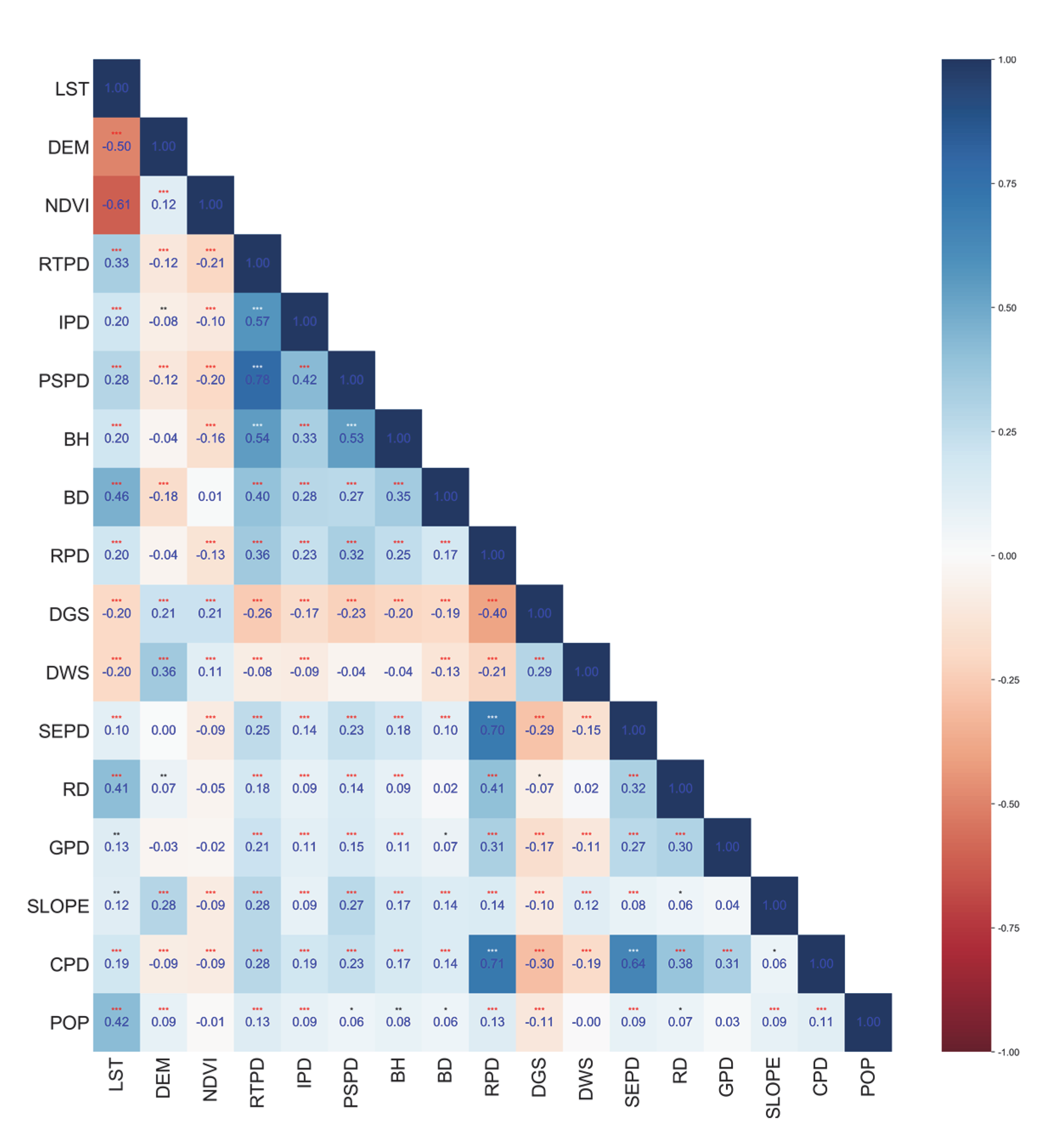
3.2. Results of Natural Condition/Socioeconomic Indicator Measurements
3.3. Assessing the Impact of Indicators on Urban Heat Islands
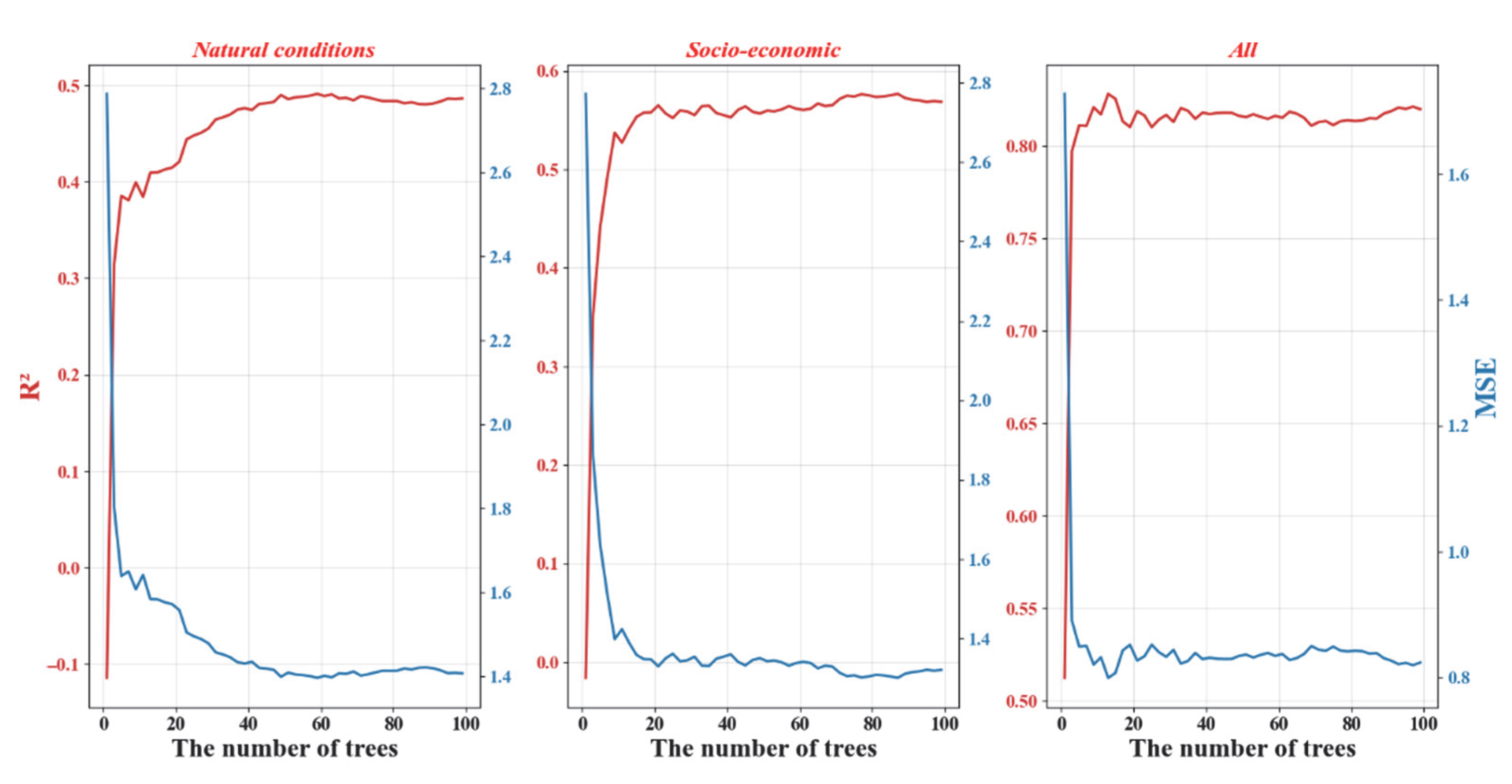
3.3.1. Grid Search Method for Determining Hyperparameters
3.3.2. Assessing the Importance of Natural and Socioeconomic Factors
4. Discussion
4.1. Implications for Urban Planning to Mitigate the Heat Island Effect
4.2. Limitations and Future Avenues
5. Conclusions
Author Contributions
Funding
Institutional Review Board Statement
Informed Consent Statement
Data Availability Statement
Conflicts of Interest
References
- Imhoff, M.L.; Zhang, P.; Wolfe, E.R.; Bounoua, L. Remote sensing of the urban heat island effect across biomes in the continental USA. Remote Sens. Environ. 2010, 114, 504–513. [Google Scholar] [CrossRef] [Green Version]
- Chen, M.; Liu, W.; Lu, D. Challenges and the way forward in China’s new-type urbanization. Land Use Policy 2016, 55, 334–339. [Google Scholar] [CrossRef]
- Fan, X.; Duan, Q.; Shen, C.; Wu, Y.; Xing, C. Global surface air temperatures in CMIP6: Historical performance and future changes. Environ. Res. Lett. 2020, 15, 104056. [Google Scholar] [CrossRef]
- Wu, Z.; Ren, Y. A bibliometric review of past trends and future prospects in urban heat island research from 1990 to 2017. Environ. Rev. 2019, 27, 241–251. [Google Scholar]
- Liu, K.; Li, X.; Wang, S.; Li, Y. Investigating the impacts of driving factors on urban heat islands in southern China from 2003 to 2015. J. Clean. Prod. 2020, 254, 120141. [Google Scholar] [CrossRef]
- Alcoforado, M.J.; Andrade, H. Global warming and the urban heat island. In Urban Ecology; Springer: Berlin, Germany, 2008; pp. 249–262. [Google Scholar]
- Yang, J.; Wang, Z.-H.; Kaloush, K.E. Environmental impacts of reflective materials: Is high albedo a ‘silver bullet’ for mitigating urban heat island? Renew. Sustain. Energy Rev. 2015, 47, 830–843. [Google Scholar] [CrossRef] [Green Version]
- Gago, E.J.; Roldan, J.; Pacheco-Torres, R.; Ordóñez, J. The city and urban heat islands: A review of strategies to mitigate adverse effects. Renew. Sustain. Energy Rev. 2013, 25, 749–758. [Google Scholar] [CrossRef]
- Lai, D.; Liu, W.; Gan, T.; Liu, K.; Chen, Q. A review of mitigating strategies to improve the thermal environment and thermal comfort in urban outdoor spaces. Sci. Total Environ. 2019, 661, 337–353. [Google Scholar] [CrossRef]
- Li, Z.L.; Tang, B.H.; Wu, H.; Ren, H.; Yan, G.; Wan, Z.; Trigo, L.F.; Sobrino, J.A. Satellite-derived land surface temperature: Current status and perspectives. Remote Sens. Environ. 2013, 131, 14–37. [Google Scholar] [CrossRef] [Green Version]
- Liu, Y.; Hiyama, T.; Yamaguchi, Y. Scaling of land surface temperature using satellite data: A case examination on ASTER and MODIS products over a heterogeneous terrain area. Remote Sens. Environ. 2006, 105, 115–128. [Google Scholar] [CrossRef]
- Sattari, F.; Hashim, M. A brief review of land surface temperature retrieval methods from thermal satellite sensors Middle-East. J. Sci. Res. 2014, 22, 757–768. [Google Scholar]
- Zhao, Y.; Wu, Q.; Wei, P.; Zhao, H.; Zhang, X.; Pang, C. Explore the Mitigation Mechanism of Urban Thermal Environment by Integrating Geographic Detector and Standard Deviation Ellipse (SDE). Remote Sens. 2022, 14, 3411. [Google Scholar] [CrossRef]
- Ma, L.; Yang, Z.; Zhou, L.; Lu, H.; Yin, G. Local climate zones mapping using object-based image analysis and validation of its effectiveness through urban surface temperature analysis in China. Build. Environ. 2021, 206, 108348. [Google Scholar] [CrossRef]
- Watkins, R.; Palmer, J.; Kolokotroni, M. Increased temperature and intensification of the urban heat island: Implications for human comfort and urban design. Built Environ. 2007, 33, 85–96. [Google Scholar] [CrossRef]
- Webb, B. The use of urban climatology in local climate change strategies: A comparative perspective. Int. Plan. Stud. 2017, 22, 68–84. [Google Scholar] [CrossRef] [Green Version]
- Hokao, K.; Phonekeo, V.; Srivanit, M. Assessing the impact of urbanization on urban thermal environment: A case study of Bangkok Metropolitan. Int. J. Appl. 2012, 2, 7. [Google Scholar]
- Chen, S.; Hu, D. Parameterizing anthropogenic heat flux with an energy-consumption inventory and multi-source remote sensing data. Remote Sens. 2017, 9, 1165. [Google Scholar] [CrossRef] [Green Version]
- Wollmann, C.A.; Hoppe, I.L.; Gobo, J.P.A.; Simioni, J.P.D.; Costa, I.T.; Baratto, J.; Shooshtarian, S. Thermo-hygrometric variability on waterfronts in negative radiation balance: A case study of balneário Camboriú/SC, Brazil. Atmosphere 2021, 12, 1453. [Google Scholar] [CrossRef]
- Giorgio, G.A.; Ragosta, M.; Telesca, V. Climate variability and industrial-suburban heat environment in a Mediterranean area. Sustainability 2017, 9, 775. [Google Scholar] [CrossRef] [Green Version]
- Wang, R.; Min, J.; Li, Y.; Hu, Y.; Yang, S. Analysis on Seasonal Variation and Influencing Mechanism of Land Surface Thermal Environment: A Case Study of Chongqing. Remote Sens. 2022, 14, 9. [Google Scholar] [CrossRef]
- Zhang, N.; Ye, H.; Wang, M.; Li, Z.; Li, S.; Li, Y. Response relationship between the regional thermal environment and urban forms during rapid urbanization (2000–2010–2020): A case study of three urban agglomerations in China. Remote Sens 2022, 14, 3749. [Google Scholar] [CrossRef]
- Guerri, G.; Crisci, A.; Cresci, I.; Congedo, L.; Munafò, M.; Morabito, M. Residential Buildings’ Real Estate Values Linked to Summer Surface Thermal Anomaly Patterns and Urban Features: A Florence (Italy) Case Study. Sustainability 2022, 14, 8412. [Google Scholar] [CrossRef]
- Kim, Y.-H.; Baik, J.-J. Daily maximum urban heat island intensity in large cities of Korea. Theor. Appl. Climatol. 2004, 79, 151–164. [Google Scholar] [CrossRef]
- Halder, B.; Bandyopadhyay, J.; Banik, P. Evaluation of the climate change impact on urban heat island based on land surface temperature and geospatial indicators. Int. J. Environ. Res. 2021, 15, 819–835. [Google Scholar] [CrossRef]
- Peng, X.; Wu, W.; Zheng, Y.; Sun, J.; Hu, T.; Wang, P. Correlation analysis of land surface temperature and topographic elements in Hangzhou, China. Sci. Rep. 2020, 10, 10451. [Google Scholar] [CrossRef] [PubMed]
- Chun, B.; Guldmann, J.-M. Two- and Three-Dimensional Urban Core Determinants of the Urban Heat Island: A Statistical Approach. J. Environ. Sci. Eng. B 2012, 1, 363–378. [Google Scholar]
- Neis, P.; Zielstra, D. Recent developments and future trends in volunteered geographic information research: The case of OpenStreetMap. Future Int. 2014, 6, 76–106. [Google Scholar] [CrossRef] [Green Version]
- Graham, M.; Shelton, T. Geography and the future of big data, big data and the future of geography. Dialogues Hum. Geogr. 2013, 3, 255–261. [Google Scholar] [CrossRef] [Green Version]
- Chen, K.; Lu, W.; Xue, F.; Tang, P.; Li, L.H. Automatic building information model reconstruction in high-density urban areas: Augmenting multi-source data with architectural knowledge. Autom. Constr. 2018, 93, 22–34. [Google Scholar] [CrossRef]
- Liu, X.; Chen, M.; Claramunt, C.; Batty, M.; Kwan, M.P.; Senousi, A.M.; Cheng, T.; Strobl, J.; Cöltekin, A.; Wilson, J.; et al. Geographic information science in the era of geospatial big data: A cyberspace perspective. Innovation 2022, 3, 100279. [Google Scholar] [CrossRef]
- Zhao, P.; Liu, X.; Shen, J.; Chen, M. A network distance and graph-partitioning-based clustering method for improving the accuracy of urban hotspot detection. Geocarto Int. 2019, 34, 293–315. [Google Scholar] [CrossRef]
- He, X.; Cao, Y.; Zhou, C. Evaluation of polycentric spatial structure in the urban agglomeration of the pearl river delta (PRD) based on multi-source big data fusion. Remote Sens. 2021, 13, 3639. [Google Scholar] [CrossRef]
- Yin, J.; Dong, J.; Hamm, N.A.; Li, Z.; Wang, J.; Xing, H.; Fu, P. Integrating remote sensing and geospatial big data for urban land use mapping: A review. Int. J. Appl. Earth Obs. Geoinf. 2021, 103, 102514. [Google Scholar] [CrossRef]
- Tran, D.X.; Pla, F.; Latorre-Carmona, P.; Myint, S.W.; Caetano, M.; Kieu, H.V. Characterizing the relationship between land use land cover change and land surface temperature. ISPRS J. Photogramm. Remote Sens. 2017, 124, 119–132. [Google Scholar] [CrossRef]
- Yu, X.; Guo, X.; Wu, Z. Land surface temperature retrieval from Landsat 8 TIRS—Comparison between radiative transfer equation-based method, split window algorithm and single channel method. Remote Sens. 2014, 6, 9829–9852. [Google Scholar] [CrossRef] [Green Version]
- Zhou, S.; Cheng, J. An improved temperature and emissivity separation algorithm for the advanced Himawari imager. IEEE Trans. Geosci. Remote Sens. 2020, 58, 7105–7124. [Google Scholar] [CrossRef]
- Li, K.; Chen, Y.; Li, Y. The random forest-based method of fine-resolution population spatialization by using the international space station nighttime photography and social sensing data. Remote Sens. 2018, 10, 1650. [Google Scholar] [CrossRef] [Green Version]
- Buttan, Y.; Chaudhary, A.; Saxena, K. An improved model for breast cancer classification using random forest with grid search method. Proceedings of Second International Conference on Smart Energy and Communication; Springer: Singapore, 2021; pp. 407–415. [Google Scholar]
- Pekel, E. Estimation of soil moisture using decision tree regression. Theor. Appl. Climatol. 2020, 139, 1111–1119. [Google Scholar] [CrossRef]
- Zhang, H.; Qi, Z.F.; Ye, X.Y.; Cai, Y.B.; Ma, W.C.; Chen, M.N. Analysis of land use/land cover change, population shift, and their effects on spatiotemporal patterns of urban heat islands in metropolitan Shanghai, China. Appl. Geogr. 2013, 44, 121–133. [Google Scholar] [CrossRef]
- Lawrence, M.G.; Lelieveld, J. Atmospheric pollutant outflow from southern Asia: A review. Atmos. Chem. Phys. 2010, 10, 11017–11096. [Google Scholar] [CrossRef] [Green Version]
- Zhu, S.; Liu, Y.; Hua, J.; Zhang, G.; Zhou, Y.; Xialng, J. Monitoring spatio-temporal variance of an extreme heat event using multiple-source remote sensing data. Chin. Geogr. Sci. 2018, 28, 744–757. [Google Scholar] [CrossRef] [Green Version]
- Sadiq Khan, M.; Ullah, S.; Sun, T.; Rehman, A.U.; Chen, L. Land-use/land-cover changes and its contribution to urban heat Island: A case study of Islamabad, Pakistan. Sustainability 2020, 12, 3861. [Google Scholar] [CrossRef]
- Chatzidimitriou, A.; Yannas, S. Microclimate development in open urban spaces: The influence of form and materials. Energy Build. 2015, 108, 156–174. [Google Scholar] [CrossRef]
- Singh, P.; Kikon, N.; Verma, P. Impact of land use change and urbanization on urban heat island in Lucknow city, Central India. A remote sensing based estimate. Sustain. Cities Soci. 2017, 32, 100–114. [Google Scholar] [CrossRef]
- Chen, X.; Zhang, Y. Impacts of urban surface characteristics on spatiotemporal pattern of land surface temperature in Kunming of China. Sustain. Cities Soci. 2017, 32, 87–99. [Google Scholar] [CrossRef] [Green Version]
- Wu, Z.; Man, W.; Ren, Y. Influence of tree coverage and micro-topography on the thermal environment within and beyond a green space. Agric. For. Meteorol. 2022, 316, 108846. [Google Scholar] [CrossRef]
- Wang, G.Q.; Zheng, B.H.; Yu, H.; Peng, X. Green space layout optimization based on microclimate environment features. Int. J. Sustain. Dev. Plan. 2019, 14, 9–19. [Google Scholar] [CrossRef] [Green Version]
- Feng, X.; Xiu, C.; Bai, L.; Zhong, Y.; Wei, Y. Comprehensive evaluation of urban resilience based on the perspective of landscape pattern: A case study of Shenyang city. Cities 2020, 104, 102722. [Google Scholar] [CrossRef]
- Nichols, B.G.; Kockelman, K.M. Life-cycle energy implications of different residential settings: Recognizing buildings, travel, and public infrastructure. Energy Policy 2014, 68, 232–242. [Google Scholar] [CrossRef] [Green Version]
- Omer, A.M. Energy, environment and sustainable development. Renew. Sustain. Energy Rev. 2008, 12, 2265–2300. [Google Scholar] [CrossRef]
- Li, B.; Xing, H.; Cao, D.; Yang, G.; Zhang, H. Exploring the Effects of Roadside Vegetation on the Urban Thermal Environment Using Street View Images. Int. J. Environ. Res. Public Health 2022, 19, 1272. [Google Scholar] [CrossRef] [PubMed]
- Zhou, D.; Xiao, J.; Bonafoni, S.; Berger, C.; Deilami, K.; Zhou, Y.; Frolking, S.; Yao, R.; Qiao, Z.; Sobrino, J.A. Satellite remote sensing of surface urban heat islands: Progress, challenges, and perspectives. Remote Sens. 2018, 11, 48. [Google Scholar] [CrossRef]


| Data Name | Data Source | Acquisition Time | Data Type |
|---|---|---|---|
| Administrative Divisions | National Basic Geographic Database | / | Vector |
| Landsat8 image | http://www.gscloud.cn/ | 28 August 2020 | Raster |
| Points of Interest | Gaode Map | September 2020 | Vector |
| Land Cover Data | FROM-GLC10 | 2020 | Raster |
| DEM | http://www.gscloud.cn/ | 2020 | Raster |
| Building Data | Gaode Map | 2020 | Vector |
| Population data | WorldPop | 2020 | Raster |
| Road Data | OpenStreetMap | 2020 | Vector |
| Water System | OpenStreetMap | 2020 | Vector |
| Green Space | OpenStreetMap | 2020 | Vector |
| Types | Metrics | Formula and Description |
|---|---|---|
| Natural-condition indicators | DEM | / |
| Slope | / | |
| NDVI | ||
| Distance to green space (DGS) | Proximity Analysis | |
| Distance to water system (DWS) | Proximity Analysis | |
| Socioeconomic indicators | Average building height (BH) | |
| Building density (BD) | ||
| Road network density (RD) | ||
| Population (POP) | WorldPop data | |
| Road traffic POI density (RTPD) | Zoning Statistics | |
| Public Service POI Density (PSPD) | Zoning Statistics | |
| Residential POI Density (RPD) | Zoning Statistics | |
| Commercial POI Density (CPD) | Zoning Statistics | |
| Greenland Square POI Density (GPD) | Zoning Statistics | |
| Science and education POI density (SEPD) | ||
| Industrial POI Density (IPD) | Zoning Statistics |
Publisher’s Note: MDPI stays neutral with regard to jurisdictional claims in published maps and institutional affiliations. |
© 2022 by the authors. Licensee MDPI, Basel, Switzerland. This article is an open access article distributed under the terms and conditions of the Creative Commons Attribution (CC BY) license (https://creativecommons.org/licenses/by/4.0/).
Share and Cite
Lu, X.; Wang, H.; Chen, H.; Gao, S. Assessing the Impact of Natural Conditions/Socioeconomic Indicators on the Urban Thermal Environment Based on Geographic Big Data. Atmosphere 2022, 13, 1942. https://doi.org/10.3390/atmos13121942
Lu X, Wang H, Chen H, Gao S. Assessing the Impact of Natural Conditions/Socioeconomic Indicators on the Urban Thermal Environment Based on Geographic Big Data. Atmosphere. 2022; 13(12):1942. https://doi.org/10.3390/atmos13121942
Chicago/Turabian StyleLu, Xiaolong, Haihui Wang, Huanliang Chen, and Shuai Gao. 2022. "Assessing the Impact of Natural Conditions/Socioeconomic Indicators on the Urban Thermal Environment Based on Geographic Big Data" Atmosphere 13, no. 12: 1942. https://doi.org/10.3390/atmos13121942