
Spatio-Temporal Assessment of Thunderstorms’ Effects on Wildfire in Australia in 2017–2020 Using Data from the ISS LIS and MODIS Space-Based Observations


Abstract
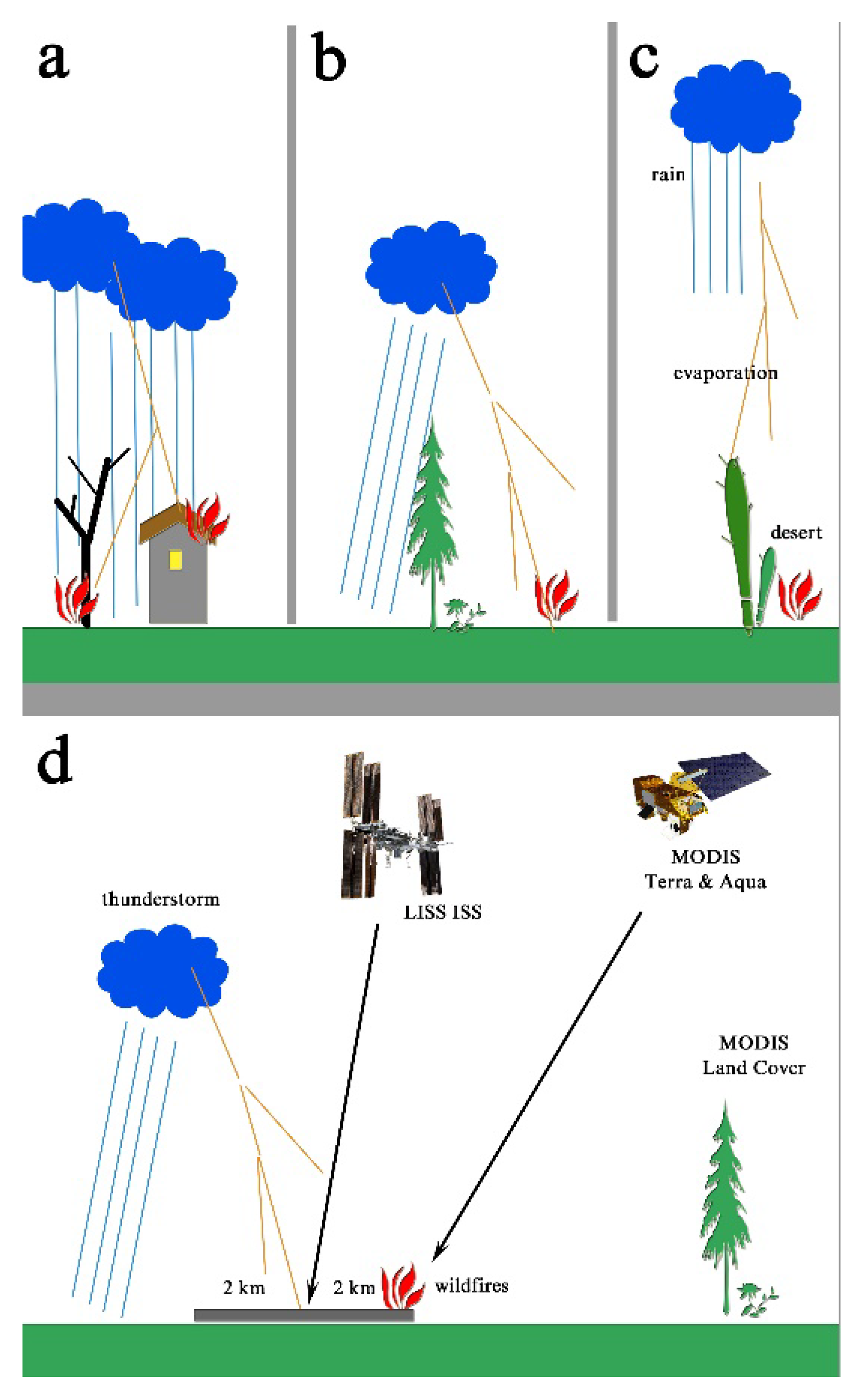
:1. Introduction
2. Materials and Methods
2.1. Lightning Imaging Sensor
2.2. MODIS Land Cover
2.3. The Lightning Land-Cover Retrieval Method
2.4. MODIS Active Fires
2.5. Lightning Wildfire Retrieval Method
3. Results
3.1. Seasonal Variations in Lightning Flashes
3.2. The Lightning Flashes and Different Vegetation Classes
3.3. Spatial Distribution of Lightning Wildfires
4. The Spatial Distributions of Lightning Wildfires
4.1. Lightning Wildfires in the Open Shrublands
4.2. The Lightning Wildfires in Forests
4.3. The Sheet Lightning Wildfires at the Boundary of a Thunderstorm
5. Discussion
6. Conclusions
Supplementary Materials
Funding
Institutional Review Board Statement
Informed Consent Statement
Data Availability Statement
Conflicts of Interest
References
- Flannigan, M.; Cantin, A.S.; de Groot, W.J.; Wotton, M.; Newbery, A.; Gowman, L.M. Global wildland fire season severity in the 21st century. For. Ecol. Manag. 2013, 294, 54–61. [Google Scholar] [CrossRef]
- Price, C.; Rind, D. A simple lightning parameterization for calculating global lightning distributions. J. Geophys. Res. 1992, 97, 9919–9933. [Google Scholar] [CrossRef]
- Price, C.; Rind, D. What determines the cloud-to-ground lightning fraction in thunderstorms? Geophys. Res. Lett. 1993, 20, 463–466. [Google Scholar] [CrossRef]
- Price, C.; Rind, D. Possible implications of global climate change on global lightning distributions and frequencies. J. Geophys. Res. 1994, 99, 10823–10831. [Google Scholar] [CrossRef]
- Price, C.; Penner, J. NOx from lightning 1. Global distribution based on lightning physics. J. Geophys. Res. 1997, 102, 5929–5941. [Google Scholar] [CrossRef] [Green Version]
- Abatzoglou, J.T.; Kolden, C.A.; Balch, J.K.; Bradley, B.A. Controls on interannual variability in lightning-caused fire activity in the western US. Environ. Res. Lett. 2016, 11, 045005. [Google Scholar] [CrossRef]
- Stocks, B.J.; Mason, J.A.; Todd, J.B.; Bosch, E.M.; Wotton, B.M.; Amiro, B.D.; Flannigan, M.D.; Hirsch, K.G.; Logan, K.A.; Martell, D.L.; et al. Large forest fires in Canada, 1959–1997. J. Geophys. Res. 2003, 108, 8149. [Google Scholar] [CrossRef]
- Veraverbeke, S.; Rogers, B.M.; Goulden, M.L.; Jandt, R.R.; Miller, C.E.; Wiggins, E.B.; Randerson, J.T. Lightning as a major driver of recent large fire years in North American boreal forests. Nat. Clim. Chang. 2017, 7, 529–534. [Google Scholar] [CrossRef]
- Balch, J.K.; Bradley, B.A.; Abatzoglou, J.T.; Chelsea Nagy, R.; Fusco, E.J.; Mahood, A.L. Human-started wildfires expand the fire niche across the United States. Proc. Natl. Acad. Sci. USA 2017, 114, 2946–2951. [Google Scholar] [CrossRef] [Green Version]
- Wang, Y.; Anderson, K.R. An evaluation of spatial and temporal patterns of lightning- and human-caused forest fires in Alberta, Canada, 1980–2007. Int. J. Wildland Fire 2010, 19, 1059–1072. [Google Scholar] [CrossRef]
- Abdollahi, M.; Dewan, A.; Hassan, Q.K. Applicability of Remote Sensing-Based Vegetation Water Content in Modeling Lightning-Caused Forest Fire Occurrences. MDPI Int. J. Geo-Inf. 2019, 8, 143. [Google Scholar] [CrossRef] [Green Version]
- Uman, M.A. Cloud and Lightning Charges; Elsevier: Amsterdam, The Netherlands, 1987; Volume 39, pp. 58–70. [Google Scholar]
- Saunders, C. A review of thunderstorm electrification processes. J. Appl. Meteorol. 1993, 32, 642–655. [Google Scholar] [CrossRef]
- Miller, K.; Gadian, A.; Saunders, C.; Latham, J.; Christian, H. Modelling and observations of thundercloud electrification and lightning. Atmos. Res. 2001, 58, 89–115. [Google Scholar] [CrossRef]
- Nauslar, N.J.; Hatchett, B.J. Dry Thunderstorms. In Encyclopedia of Wildfires and Wildland-Urban Interface (WUI) Fires; Manzello, S.L., Ed.; Springer International Publishing: Cham, Switzerland, 2018; pp. 1–10. [Google Scholar]
- Schumacher, V.; Setzer, A.; Saba, M.M.F.; Naccarato, K.P.; Mattos, E.; Justino, F. Characteristics of lightning-caused wildfires in central Brazil in relation to cloud-ground and dry lightning. Agric. For. Meteorol. 2022, 312, 108723. [Google Scholar] [CrossRef]
- Dowdy, A.J.; Mills, G.A. Atmospheric and fuel moisture characteristics associated with lightning-attributed fires. J. Appl. Meteorol. Climatol. 2012, 51, 2025–2037. [Google Scholar] [CrossRef]
- Bates, B.C.; Dowdy, A.J.; Chandler, R.E. Classification of Australian thunderstorms using multivariate analyses of largescale atmospheric variables. J. Appl. Meteorol. Climatol. 2017, 56, 1921–1937. [Google Scholar] [CrossRef]
- Dowdy, A.J. Climatology of thunderstorms, convective rainfall and dry lightning environments in Australia. Clim. Dyn. 2020, 54, 3041–3052. [Google Scholar] [CrossRef]
- Van Oldenborgh, G.J.; Krikken, F.; Lewis, S.; Leach, N.J.; Lehner, F.; Saunders, K.R.; van Weele, M.; Haustein, K.; Li, S.; Wallom, D.; et al. Attribution of the Australian bushfire risk to anthropogenic climate change. Nat. Hazards Earth Syst. Sci. 2021, 21, 941–960. [Google Scholar] [CrossRef]
- Harris, S.; Lucas, C. Understanding the variability of Australian fire weather between 1973 and 2017. PLoS ONE 2019, 14, e0222328. [Google Scholar] [CrossRef]
- Liu, Y.; Williams, E.; Li, Z.; Guha, A.; Lapierre, J.; Stock, M.; Heckman, S.; Zhang, Y.; DiGangi, E. Lightning enhancement in moist convection with smoke-laden air advected from Australian wildfires. Geophys. Res. Lett. 2021, 48, e2020GL092355. [Google Scholar] [CrossRef]
- Kramer, D. What caused Australia’s disastrous wildfires? It’s complicated. Phys. Today 2020, 73, 26. [Google Scholar] [CrossRef] [Green Version]
- Haque, M.K.; Azad, M.A.K.; Hossain, M.Y.; Ahmed, T.; Uddin, M.; Hossain, M.M. Wildfire in Australia during 2019-2020, Its Impact on Health, Biodiversity and Environment with Some Proposals for Risk Management: A Review. J. Environ. Prot. 2021, 12, 391–414. [Google Scholar] [CrossRef]
- Abram, N.J.; Henley, B.J.; Gupta, A.S.; Lippmann, T.J.R.; Clarke, H.; Dowdy, A.J.; Sharples, J.J.; Nolan, R.H.; Zhang, T.; Wooster, M.J.; et al. Connections of climate change and variability to large and extreme forest fires in southeast Australia. Commun. Earth Environ. 2021, 2, 8. [Google Scholar] [CrossRef]
- Blakeslee, J.R. Quality Controlled Lightning Imaging Sensor (LIS) on International Space Station (ISS) Science Data. Dataset available online from the NASA Global Hydrology Resource Center DAAC, Huntsville, AL, USA, 2020. Available online: https://cmr.earthdata.nasa.gov/search/concepts/C2015490897-GHRC_DAAC.html (accessed on 15 February 2022).
- GHRC Global Hydrology Resource Center. The ISS LIS Datasets. Available online: https://ghrc.nsstc.nasa.gov/pub/lis/iss/data/science/final/nc/ (accessed on 15 February 2022).
- Poelman, D.R.; Schulz, W. Comparing lightning observations of the ground-based European lightning location system EUCLID and the space-based Lightning Imaging Sensor (LIS) on the International Space Station (ISS). Atmos. Meas. Tech. 2020, 13, 2965–2977. [Google Scholar] [CrossRef]
- Albrecht, R.; Goodman, S.; Buechler, D.; Blakeslee, R.; Christian, H. Where are the lightning hotspots on Earth? Bull. Amer. Meteor. Soc. 2016, 97, 2051–2068. [Google Scholar] [CrossRef]
- Beirle, S.; Koshak, W.; Blakeslee, R.; Wagner, T. Global patterns of lightning properties derived by OTD and LIS. Nat. Hazards Earth Syst. Sci. Discuss. 2014, 2, 2765–2787. [Google Scholar] [CrossRef] [Green Version]
- Rudlosky, S.; Shea, D.T. Evaluating WWLLN performance relative to TRMM/LIS. Geophys. Res. Lett. 2013, 40, 2344–2348. [Google Scholar] [CrossRef]
- Zhang, W.; Zhang, Y.; Zheng, D.; Xu, L.; Lyu, W. Lightning climatology over the northwest Pacific region: An 11-year study using data from the World Wide Lightning Location Network. Atmos. Res. 2018, 210, 41–57. [Google Scholar] [CrossRef]
- Zhang, D.; Cummins, K.L.; Nag, A.; Murphy, M.J.; Bitzer, P.M. Evaluation of the National Lightning Detection Network Upgrade Using the Lightning Imaging Sensor. In Proceedings of the 26th International Lightning Detection Conference & 6th International Lightning Meteorology Conference (ILDC/ILMC), San Diego, CA, USA, 18–21 April 2016. [Google Scholar]
- Rudlosky, S. Evaluating ENTLN Performance Relative to TRMM/LIS. J. Oper. Meteorol. 2015, 3, 11–20. [Google Scholar] [CrossRef]
- Enno, S.; Sugier, J.; Labrador, L.J.; Rudlosky, S. Comparison and characterisation of ATDnet versus LIS for the period of 2008 to 2014. In Proceedings of the 25th International Lightning Detection Conference & 7th International Lightning Meteorology Conference (ILDC/ILMC), Ft. Lauderdale, FL, USA, 12 March 2018; pp. 1–7. [Google Scholar]
- Said, R.K.; Inan, U.S.; Cummins, K.L. Longrange lightning geolocation using a VLF radio atmospheric waveform bank. J. Geophys. Res.-Atmos. 2010, 115, D23108. [Google Scholar] [CrossRef] [Green Version]
- Said, R.K.; Cohen, M.B.; Inan, U.S. Highly intense lightning over the oceans: Estimated peak currents from global GLD360 observations. J. Geophys. Res.-Atmos. 2013, 118, 6905–6915. [Google Scholar] [CrossRef] [Green Version]
- Schulz, W.; Diendorfer, G.; Pedeboy, S.; Poelman, D.R. The European lightning location system EUCLID—Part 1: Performance analysis and validation. Nat. Hazards Earth Syst. Sci. 2016, 16, 595–605. [Google Scholar] [CrossRef] [Green Version]
- LIS STDS LIS Space Time Domain Search. 2021. Available online: https://lightning.nsstc.nasa.gov/isslisib/isslissearch.html (accessed on 15 February 2022).
- Safronov, A.N. Efects of ClimaticWarming and Wildfires on Recent Vegetation Changes in the Lake Baikal Basin. MDPI Clim. 2020, 8, 57. [Google Scholar] [CrossRef]
- Earth Explorer Server. Available online: https://earthexplorer.usgs.gov/ (accessed on 15 February 2022).
- Sulla-Menashe, D.; Friedl, M.A. User Guide to Collection 6 MODIS Land Cover (MCD12Q1 and MCD12C1) Product. 2018. Available online: https://lpdaac.usgs.gov/documents/101/MCD12_User_Guide_V6.pdf (accessed on 15 February 2022). [CrossRef]
- ESRI ArcInfo GIS System. Description. Available online: https://www.esri.com (accessed on 15 February 2022).
- MCD14ML University of Maryland Fuoco SFTP Server. 2022. Available online: Sftp://fuoco.geog.umd.edu/MODIS/C6/MCD14ML (accessed on 15 February 2022).
- UMD Server University of Maryland Fuoco SFTP. 2022. Available online: Sftp://fuoco.geog.umd.edu (accessed on 15 February 2022).
- Giglio, L.; Schroeder, W.; Hall, J.V.; Justice, C.O. MODIS Collection 6 and Collection 6.1, Active Fire Product User’s Guide, Version 1.0. Available online: Sftp://fuoco.geog.umd.edu/MODIS/C6/docs/MODIS_C6_C6.1_Fire_User_Guide_1.0.pdf (accessed on 15 February 2022).
- ABARES Australian Forests. Available online: https://www.awe.gov.au/sites/default/files/abares/forestsaustralia/documents/sofr_2018/maps%20and%20other%20graphics/c1/SOFR_2018_Fig_1_1_Forest_extent_by_type.png (accessed on 15 February 2022).
- Romps, D.M.; Seeley, J.T.; Vollaro, D.; Molinari, J. Projected increase in lightning strikes in the United States due to global warming. Science 2014, 851, 346. [Google Scholar] [CrossRef] [PubMed]
- Giglio, L.; Boschetti, L.; Roy, D.P.; Humber, M.L.; Justice, C.O. The Collection 6 MODIS burned area mapping algorithm and product. Remote Sens. Environ. 2018, 217, 72–85. [Google Scholar] [CrossRef] [PubMed]
- Larjavaara, M.; Pennanen, J.; Tuomi, T. Lightning that ignites forest fires in Finland. Agric. For. Meteorol. 2005, 132, 171–180. [Google Scholar] [CrossRef]
- Wierzchowski, J.; Heathcott, M.; Flannigan, M.D. Lightning and lightning fire, central cordillera, Canada. Int. J. Wildland Fire 2002, 11, 41–51. [Google Scholar] [CrossRef]
- Nash, C.H.; Johnson, E.A. Synoptic climatology of lightning-caused forest fires in subalpine and boreal forests. Can. J. For. Res. 1996, 26, 1859–1874. [Google Scholar] [CrossRef]
- Perez-Invernon, F.J.; Huntrieser, H.; Soler, S.; Gordillo-Vazquez, F.J.; Pineda, N.; Navarro-Gonzalez, J.; Reglero, V.; Montanya, J.; van der Velde, O.; Koutsias, N. Lightning-ignited wildfires and long continuing current lightning in the Mediterranean Basin: Preferential meteorological conditions. Atmos. Chem. Phys. 2021, 21, 17529–17557. [Google Scholar] [CrossRef]


| Dataset | Satellite | Description | Spatial Resolution | Spatial Cover | Time Window | Temporal Coverage | Variables |
|---|---|---|---|---|---|---|---|
| LIS | ISS | Optical lightning data | 4 kmin nadir | 54.3° N –54.3° S | Daily | March 2017–present | Time and location of groups and lightning flashes |
| MCD14ML | Terra and Aqua | Wildfire hotspots | 500 m | World | Daily | Terra (1999–present) Aqua (2002–present) | Time and location of active fires |
| MCD12Q1 | Terra and Aqua | Classification of vegetation type | 1 km | World | Yearly | 2018 | IGBP classes |
| GDAS | – | Meteorological data | 1° × 1° | World | 3 h | 1978–present | surface wind speed, cloud fraction (mcld, hcld) |
| ABARES | – | Classification of Australian forest type | 100 m | Australia | 2018 | 2018 | Eucalypt forests |
| Month | Seasons in Australia | Years | ||||
|---|---|---|---|---|---|---|
| 2017 | 2018 | 2019 | 2020 | |||
| 1 | January | Summer | – | 9604 | 3702 | 7191 |
| 2 | February | – | 6222 | 5078 | 6156 | |
| 3 | March | Autumn | 5593 | 3342 | 6013 | 1250 |
| 4 | April | 261 | 551 | 53 | 808 | |
| 5 | May | 134 | 5 | 408 | 21 | |
| 6 | June | Winter | 0 | 32 | 31 | 21 |
| 7 | July | 22 | 11 | 13 | 47 | |
| 8 | August | 123 | 25 | 1 | 176 | |
| 9 | September | Spring | 141 | 232 | 75 | 1099 |
| 10 | October | 2067 | 4680 | 2023 | 7118 | |
| 11 | November | 9096 | 8036 | 2587 | 6156 | |
| 12 | December | Summer | 3690 | 4440 | 8164 | 4331 |
| Annual | 21,127 | 37,180 | 28,148 | 34,374 | ||
| Month | Seasons in Australia | Years | ||||
|---|---|---|---|---|---|---|
| 2017 | 2018 | 2019 | 2020 | |||
| 1 | January | Summer | – | 0 | 2 (1) | (1) |
| 2 | February | – | 0 | 3 | 1 | |
| 3 | March | Autumn | 0 | 0 | 2 (1) | 0 |
| 4 | April | 0 | 0 | 0 | 0 | |
| 5 | May | 0 | 0 | 0 | 0 | |
| 6 | June | Winter | 0 | 0 | 0 | 0 |
| 7 | July | 0 | 0 | 0 | 0 | |
| 8 | August | 0 | 0 | 0 | 0 | |
| 9 | September | Spring | 0 | 0 | 0 | 0 |
| 10 | October | 2 | 0 | 2 (1) | 1 | |
| 11 | November | 3 | 3 (3) | 0 | 1 | |
| 12 | December | Summer | 1 (1) | 0 | 2 (1) | 0 |
| Total lightning wildfires, pcs. | 6 (1) | 3 (3) | 11 (4) | 3 (1) | ||
| Total events, in % | 0.028 | 0.008 | 0.039 | 0.009 | ||
| Annual ISS LIS flashes | 21,127 | 37,180 | 28,148 | 34,374 | ||
| ID | IGBP Classes | Numbers of Lightning Wildfires, pcs. | ||||
|---|---|---|---|---|---|---|
| 2017 | 2018 | 2019 | 2020 | 2017–2020 | ||
| 0 | Water Bodies | |||||
| 1 | Evergreen Needleleaf Forests | |||||
| 2 | Evergreen Broadleaf Forests | 1 | 1 | |||
| 3 | Deciduous Needleleaf Forests | (1) | (1) | |||
| 4 | Deciduous Broadleaf Forests | |||||
| 5 | Mixed Forests | 1 | 1 | |||
| 6 | Closed Shrublands | 1 | 1 | |||
| 7 | Open Shrublands | 5 (1) | 2 | 5 (3) | 1 | 13 (4) |
| 8 | Woody Savannas | 1 | 1 | |||
| 9 | Savannas | (1) | 2 | (1) | 2 (2) | |
| 10 | Grasslands | 1 | (2) | 2 | 1 | 4 (2) |
| 11 | Permanent Wetlands | |||||
| 12 | Croplands | |||||
| 13 | Urban and Built-up Lands | |||||
| 14 | Natural Vegetation Mosaic | |||||
| 15 | Permanent Snow and Ice | |||||
| 16 | Barren | |||||
| 17 | Unclassified | |||||
| Total lightning wildfires, pcs. | 6 (1) | 3 (3) | 11 (4) | 3 (1) | 23 (9) | |
| Annual ISS LIS flashes | 21,127 | 37,180 | 28,148 | 34,374 | 120,829 | |
Publisher’s Note: MDPI stays neutral with regard to jurisdictional claims in published maps and institutional affiliations. |
© 2022 by the author. Licensee MDPI, Basel, Switzerland. This article is an open access article distributed under the terms and conditions of the Creative Commons Attribution (CC BY) license (https://creativecommons.org/licenses/by/4.0/).
Share and Cite
Safronov, A.N. Spatio-Temporal Assessment of Thunderstorms’ Effects on Wildfire in Australia in 2017–2020 Using Data from the ISS LIS and MODIS Space-Based Observations. Atmosphere 2022, 13, 662. https://doi.org/10.3390/atmos13050662
Safronov AN. Spatio-Temporal Assessment of Thunderstorms’ Effects on Wildfire in Australia in 2017–2020 Using Data from the ISS LIS and MODIS Space-Based Observations. Atmosphere. 2022; 13(5):662. https://doi.org/10.3390/atmos13050662
Chicago/Turabian StyleSafronov, Alexander N. 2022. "Spatio-Temporal Assessment of Thunderstorms’ Effects on Wildfire in Australia in 2017–2020 Using Data from the ISS LIS and MODIS Space-Based Observations" Atmosphere 13, no. 5: 662. https://doi.org/10.3390/atmos13050662