Article

Using a Digital Twin to Study the Influence of Climatic Changes on High Ozone Levels in Bulgaria and Europe

1
Department of Environmental Science, Aarhus University, 4000 Roskilde, Denmark
2
Institute of Information and Communication Technologies, Bulgarian Academy of Sciences, 1113 Sofia, Bulgaria
*
Author to whom correspondence should be addressed.
Atmosphere 2022, 13(6), 932; https://doi.org/10.3390/atmos13060932
Submission received: 13 April 2022 / Revised: 31 May 2022 / Accepted: 2 June 2022 / Published: 8 June 2022
(This article belongs to the Special Issue Atmospheric Composition and Regional Climate Studies in Bulgaria)

Abstract

:
High concentration levels of air pollutants may cause damage to plants, animals, and the health of some groups of human beings. Therefore, it is important to investigate different topics related to the high air pollution levels and to find reliable answers to the questions about the possible damages, which might take place when these levels exceed some limits. A few of the numerous questions, the answers of which are highly desirable, are listed below: (a) When are the air pollution levels dangerous? (b) What is the reason for the increased air pollution levels? (c) How can the air pollution levels be decreased? (d) Will the future climate changes result in higher and more dangerous air pollution levels? It is necessary to study carefully many issues connected with the distribution of air pollutants in a given region and with the reasons for the increases of the concentrations to high levels, which might be damaging. In order to do this, it is necessary to develop a Digital Twin of all relevant physical processes in the atmosphere and to use after that this tool in different applications. Such a tool, its name is DIGITAL AIR, has been created. Digital Twins are becoming more and more popular). Many complex problems, arising taking place in very complicated surroundings, can be handled and resolved successfully by applying Digital Twins. The preparation of such a digital tool as well as its practical implementation in the treatment of a special problem, the increase of some potentially dangerous ozone levels, will be discussed and tested in this paper. The Unified Danish Eulerian Model (UNI-DEM) is a very important part of DIGITAL AIR. This mathematical model, UNI-DEM, can be applied in many different studies related to damaging effects caused by high air pollution levels. We shall use it in this paper to get a reliable answer to a very special but extremely important question: will the future climatic changes lead to an increase in the ozone pollution levels in Bulgaria and Europe, which can potentially become dangerous for human health?

1. Introduction

One of the most important conclusions in the Sixth Report (AR6) of the International Panel for Climate Changes (IPCC), published in August 2021, is that “Each of the last four decades has been successively warmer than any decade that preceded it” (Paragraph A.1.2., page 6 in [1]). The concentrations of some of the air pollutants (including here pollutants, which may have harmful effects on plants, animals, and human health) depend on the temperature and the effects of the damages can be increased considerably when the temperature is becoming higher. This conclusion and the clear statement about the future increase of temperature made by the specialists from IPCC explains why it becomes more and more important to study the influence of the climatic changes on the pollution levels.
It should be mentioned that the levels of the natural (biogenic) emissions are becoming higher when the temperature is increased. This additional fact is also leading to increased levels of some potentially dangerous pollutants; including the levels of the ozone concentrations.
We shall discuss some possible future changes in the ozone concentrations that will be caused by the expected increase in the temperature levels in Europe, which is predicted by the IPCC specialists. In order to discuss this important topic, we shall apply a Digital Twin, namely a DIGITAL AIR. The application of Digital Twins is becoming more and more popular (see, for example, [2,3,4,5,6,7,8,9,10,11,12]). DIGITAL AIR contains, among many other things, many numerical algorithms, several splitting techniques, a lot of graphical tools, a series of useful scenarios, very large files of meteorological and emission data, and a big set of geographical information (for example, information about many cities in Europe and about the borders of the European countries). We call our Digital Twin Digital Air because it presents in an accurate way all the relevant processes in the air including advection, diffusion, and chemical reactions. In other words, the twin Digital Air contains all the needed phenomena and properties arising in the air that determine the climate and weather. With a detailed analysis of computational errors, and the sustainability of the algorithms, we can ensure very good and predictable proximity of the digital twin to the real system. The Unified Danish Eulerian Model (UNI-DEM) combined with several appropriate climatic scenarios plays a central and very important role in Digital Air. Since the computational tasks are extremely large we have prepared a High-Performance Computer (HPC) platform to run the Digital Air on Supercomputers [13,14,15,16,17]. There are also other approaches like Distributed Digital Twins (DDT) platforms [4] (see, also https://cordis.europa.eu/project/id/857191/reporting (accessed on 12 April 2022)). DDT platforms are very effective for big data analytics, machine learning, and model training. At the same time, these platforms are not very suitable when extremely large data flow needs to be treated numerically with high accuracy. In the latter case, the HPC platforms are more efficient. This is the reason why we are using an HPC platform. This platform is developed in a number of EU and national projects using supercomputers Avitohol (https://www.iict.bas.bg/avitohol/ (accessed on 12 April 2022)), Discoverer (https://www.trendingtopics.eu/bulgarias-discoverer-is-one-of-the-worlds-top-100-supercomputers/ (accessed on 12 April 2022)) and Mare Nostrum (https://www.bsc.es/marenostrum/marenostrum (accessed on 12 April 2022)). More information about these projects may be found in https://pure.au.dk/portal/en/persons/zahari-zlatev(16669f48-d8f9-451d-8d6b-b7ecc3fae3b2).html (accessed on 12 April 2022) and https://parallel.bas.bg/dpa/BG/dimov/projects.htm (accessed on 12 April 2022).
The selected for use in this paper climatic scenarios are based on recommendations made by the specialists from IPCC in several of their reports (see, for example, [18,19]) and are strongly emphasized in the last one, [19]. Some recommendations of other specialists are also taken into account.
We are mainly interested in the situation in Bulgaria, but many results for the whole of Europe will also be given in order to compare the pollution levels in Bulgaria with the corresponding pollution levels in some other parts of the continent. Many results and plots will be given in order to illustrate the power of DIGITAL AIR, developed by us.
A short description of the structure of the most important tool used in DIGITAL AIR, the structure of the large-scale air pollution model UNI-DEM, will be given in Section 2. Some information about the numerical treatment of this comprehensive mathematical model will also be given there. Much more details about UNI-DEM and the large set of numerical procedures used in its treatment can be found in [13,15]; see also [14,16,17,18,19,20,21,22,23] about different applications of this model. New mathematical approaches [23,24] are used to perform sensitivity analysis of results produced by UNI-DEM. These techniques are very important to check the proximity of the Digital Twin to the real system.
The main principles, which are applied by our climatic scenarios that are incorporated in DIGITAL AIR, will be discussed in Section 3. These principles are similar to the principles used in several previous papers, see [13,15,16,17,18,19,20,21,22,23,24], but some recommendations made in [1] are also taken into account.
The need to develop scenarios, which can be used to study the influence of the natural (biogenic) emissions on the high ozone levels, will be also outlined and discussed in Section 3. The scenarios related to the natural (biogenic) emissions are also included in the DIGITAL AIR. One of these scenarios is used in this paper.
Results about high ozone pollution levels in Europe and its surroundings, which could be dangerous for some groups of human beings (as, for example, for people suffering from asthmatic diseases) will be presented and discussed in Section 4.
Several conclusions about the consequences of the increase of the ozone pollution levels in Bulgaria, which is caused by the global warming, will be presented in Section 5.
The results in Section 4 and Section 5 are illustrating how useful the DIGITAL AIR is in the study of very complicated situations connected to the future climate changes and to the potentially dangerous for some groups of people high ozone levels. It should be pointed out here that, this digital tool, the DIGITAL AIR, can also be used to study many other issues related to the damaging effects of high pollution levels.
Concluding remarks will be given in the last section of the paper, in Section 6. Discussion and concluding remarks. Plans for future work will also be sketched in this section.

2. Major Characteristics of the Unified Danish Eulerian Model

The most important part of the Digital Twin developed by us, of DIGITAL AIR, is the Unified Danish Eulerian Model (UNI-DEM). UNI-DEM is a mathematical model for studying long-range transport of air pollutants. It is described by a non-linear system of partial differential equations (PDEs):
c i t = ( uc i ) x ( vc i ) y ( wc i ) z + x ( K x c i y ) + y ( K y c i y ) + z ( K z c i z ) + Q i ( t , x , y , z , c 1 , c 2 , , c s ) + ( k 1 i + k 2 i ) c i + E i ( t , x , y , z ) , x [ a 1 , b 1 ] ,   y [ a 2 , b 2 ] ,   z [ a 3 , b 3 ] ,   t [ a , b ] ,   i = 1 , 2 ,   ,   s   .
The integer s is the number of the chemical species considered in the model. Three chemical schemes, with s = 35 ,   56   and   168 , can be selected and used in UNI-DEM. All these schemes are based on chemical reactions discussed in [1]. The versions with 35 and 56 chemical species will be used to obtain the results, which will be presented in the following sections.
The concentrations of the chemical species are denoted by c i = c i ( t , x , y , z ) and the coefficients in (1) are in general functions of the independent variables t ,   x ,   y   and   z . The wind velocities are denoted by u = u ( t , x , y , z ) , v = v ( t , x , y , z ) and w = w ( t , x , y , z ) . The diffusion coefficients are K x = K x ( t , x , y , z ) , K y = K y ( t , x , y , z ) and K z = K z ( t , x , y , z ) . The non-linear terms in the mathematical models, Q i = Q i ( t , x , y , z , c 1 , c 2 , , c s ) , are describing the chemical reactions. The dry and wet deposition coefficients are denoted by k 1 i = k 1 i ( t , x , y , z ) and k 2 i = k 2 i ( t , x , y , z ) . The terms E i = E i ( t , x , y , z ) are representing the emission sources in the model.
The surface plane of the space domain of UNI-DEM is a ( 4800   km × 4800   km ) square when a stereographic geographical projection is used. This plane contains the whole of Europe together with some of its surroundings. Each of the ten horizontal levels is discretized by using ( 10   km × 10   km ) grid-squares. This discretization produces sufficiently many cells also for small countries in Europe, such as Denmark and Bulgaria. Four other examples, which also demonstrate this fact, are given in Figure 1. Ten non-equidistant levels are used in the vertical direction.
The total number of ( 10   km × 10   km ) grid-squares in the surface level is 230 , 400 . The model is normally run with a stepsize of 30 s. Runs performed over a time-interval of 16 consecutive years will be discussed in Section 4 and Section 5 of this paper.
Let us assume that:
(a)
the spatial derivatives in (1) are discretized directly,
(b)
the First-order Backward Differentiation Formula, is applied in the solution of the large and stiff system of ordinary differential equations (ODEs) that appear after the discretization of the spatial derivatives,
(c)
the chemical scheme, namely CBM-IV scheme with 56 chemical species is selected and,
(d)
the model is run over a time interval of 16 years.
Under the above assumptions, 3600 / 30 × 24 × 365 × 16 = 16 , 819 , 200 systems of non-linear algebraic equations each of which contains 480 × 480 × 10 × 56 = 129 , 024 , 000 equations must be handled at each time-step. Iterative methods are to be used in the solution of each system of non-linear algebraic equations, which leads to the solution of very large systems of linear algebraic equations at every time-step in an inner loop and the number of these systems during a one-year run will be enormous, normally O ( 10 9 ) or even more.
The above figures are becoming smaller when the chemical scheme with 35 chemical species is selected, but also in this case the numerical problems that are to be handled are still extremely large.
The situation is becoming much more complicated when the impact of the climatic changes on the pollution levels is to be investigated, because it is necessary (a) to use different scenarios during the investigations and (b) to run the UNI-DEM over a time interval of several consecutive years.
The model defined by (1) involves several physical and chemical processes, which have different properties and, therefore, it is not very easy to find efficient numerical algorithms when the discretization of (1) has to be treated directly. This is why splitting procedures are normally used in practice. One extremely important requirement related to the selection of an appropriate splitting algorithm is to avoid the introduction of artificial boundary conditions. This can be achieved if (1) is split into three sub-models defined as follows:
c i [ 1 ] t = ( uc i [ 1 ] ) x ( vc i [ 1 ] ) y + x ( K x c i [ 1 ] x ) + y ( K y c i [ 1 ] y ) ,   i = 1 , 2 ,   ,   s   ,
  c i [ 2 ] t = Q i ( t , x , y , z , c 1 [ 2 ] , c 2 [ 2 ] , , c s [ 2 ] ) + ( k 1 i + k 2 i ) c i [ 2 ] + E i ( t , x , y , z ) ,   i = 1 , 2 ,   ,   s   ,
c i [ 3 ] t = ( wc i [ 3 ] ) z + z ( K z c i [ 3 ] z )   ,   i = 1 , 2 ,   ,   s   .
The horizontal transport (horizontal advection and horizontal diffusion) is described by the sub-model (2). The chemical reactions, the two deposition processes (dry and wet deposition) and the emission sources in the space domain are described by the sub-model (3). The two vertical processes (vertical advection and vertical diffusion) are handled by the sub-model (4).
The boundary conditions on the vertical sides of the space domain of (1) are used as boundary conditions of (2). There is no need for boundary conditions in (3), because the second sub-model does not contain space derivatives. The boundary conditions on the top and on the bottom of the space domain of (1) are used as boundary conditions of (4). This means that the boundary conditions of the original non-linear system of PDEs (1) are the same as the boundary conditions of the mathematical sub-problems defined by the three sub-models (2–4) and there is no need to introduce artificial boundary conditions when the splitting procedure selected by us is used.
It should be pointed out here that the three systems, (2–4), are defining only the three sub-models, but not the splitting procedure. The splitting procedure will be fully determined only when it is explained how these three systems of PDEs are coupled during the computational process. Sequential splitting, which is the simplest way to split the system of PDEs (1), is defined as follows.
Assume that the computations at a given time t = t k are performed and sufficiently accurate approximations of the concentrations c i ( t k , x m , y n , z q ) were calculated at all grid-points ( x m , y n , z q ) in the space domain. These approximations are used as initial conditions in the treatment of (2) and the solution of (2) is used as initial condition in the treatment of (3). The solution of (3) is used as initial condition of (4) and the solution of (4) is accepted as an approximation of the solution c i ( t k + 1 , x m , y n , z q ) of (1) at the next time-step t = t k + 1 .
The major benefit of applying any splitting procedure is the fact that an extremely large and very complicated computational task is replaced by a very large number of much simpler tasks; see [13,14]. Furthermore, one can try to select the most suitable numerical algorithms for each of the three sub-models. Finally, there is also an additional advantage, which is even more essential when the problems solved are extremely large: parallel tasks appear in a natural way when splitting procedures are used and this fact can be exploited easily and very efficiently in the attempts to reduce the computational cost of the solution process (see [14]).
The short information about the numerical treatment of UNI-DEM, which is given in this section, is sufficient for our purposes. Much more details about the numerical treatment of the model can be found in [6].
It should also be mentioned here that many other efficient large-scale air pollution models were developed and used by different scientists and groups of scientists (see, for example, [6,25,26,27,28,29,30,31,32,33,34,35,36,37,38,39]).

3. Development of Climatic Scenarios for the Unified Danish Eulerian Model

UNI-DEM has been run with fourteen different scenarios over a period of 16 consecutive years from 1989 to 2004. All these scenarios are a part of the DIGITAL AIR. Five of the 16 scenarios are relevant for this study and will be used, in a slightly modified form, in Section 4 and Section 5. The first of the selected five scenarios is the basic scenario. The next three scenarios are based on several assumptions about the future increase of the temperature based on the conclusions drawn in [1,39] as well as in the other IPCC reports. The fifth scenario is based on the expectation that the levels of the biological (natural) emissions of some air pollutants will also be increased in the future. Similar climatic scenarios were also used in [13,15,16,17,21,22,23]. The major assumptions, on which these scenarios are based, are discussed in this section.

3.1. Basic Scenario

The actual meteorological data and the actual emission data for Europe and its surroundings during the selected period of 16 consecutive years (from 1989 to 2004), are used in this scenario. These data were received from the EMEP (the European Monitoring and Evaluation Programme) database; see, for example, [1], and included in DIGITAL AIR.

3.2. First Climatic Scenario

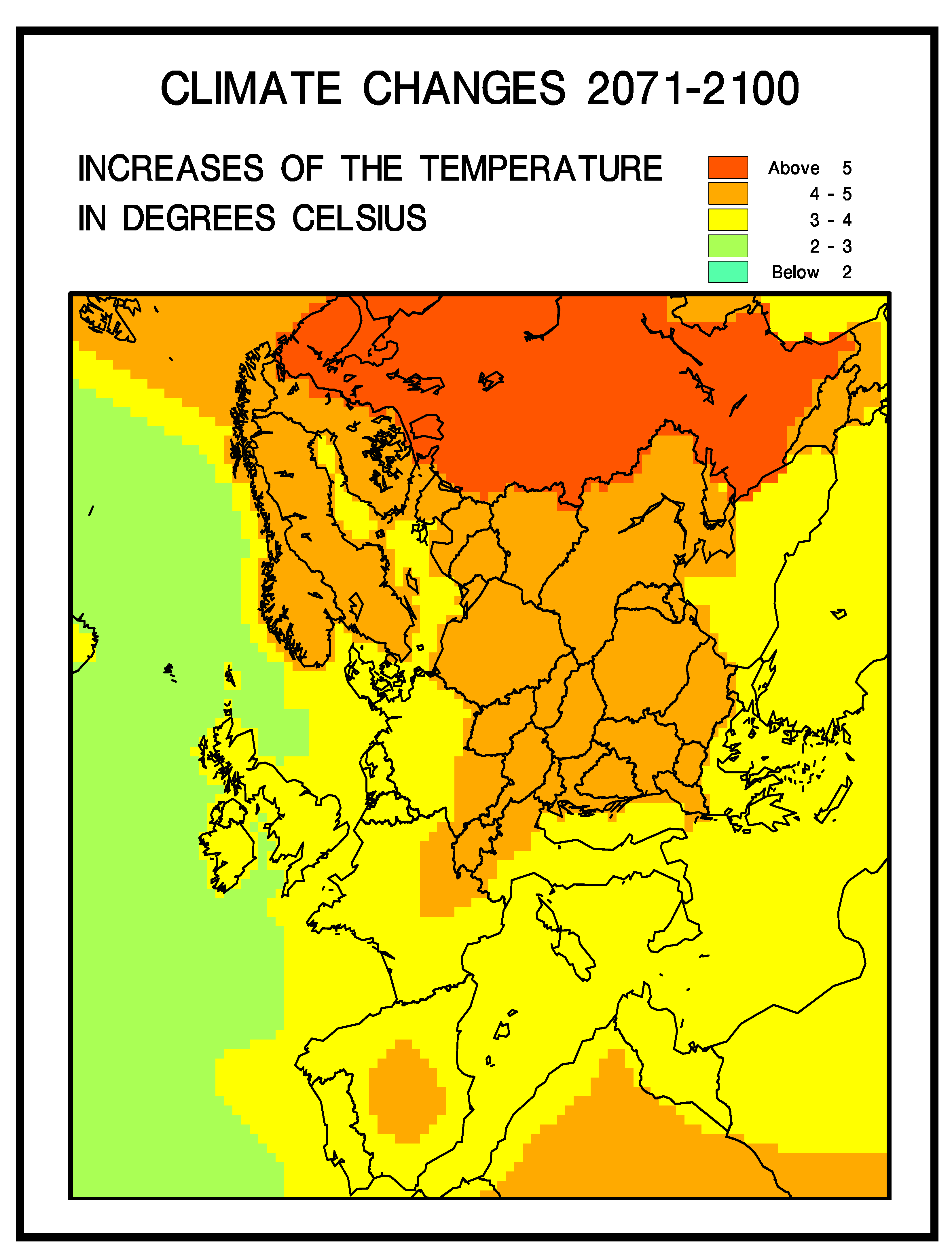
Only the temperatures are varied in the first climatic scenario. The annual changes of the temperature according to the recommendations in several of the reports of the IPCC specialists [18,19] have been used to prepare a map presenting the expectation about the future temperature in Europe in the first horizontal level of the space domain of our model; see Figure 2.
Figure 2 contains a grid of ( 480 × 480 ) cells in the first horizontal level of the space domain of UNI-DEM. Consider any of these cells and assume that the expected increase of the temperature at the chosen cell is in the interval [ α , β ] during an arbitrary hour n in the interval from the beginning of year 1989 to the end of year 2004. Then the temperature in this cell at hour n is increased by an amount of α + γ ( n )   , where γ ( n ) is randomly generated and uniformly distributed in the interval [ 0 , β α ] so that the mathematical expectation of the increase of the annual mean of the temperature at any cell from first level of the space domain for any year of the chosen interval of 16 years is ( β α ) / 2 . This means that the mean value of the annual change of the temperature at a given cell in the first horizontal level of UNI-DEM will tend to be the same as that prescribed in the IPCC reports for any of the 16 selected years.
Similar calculations were performed in the vertical direction for the cells in the other nine horizontal levels.

3.3. Second Climatic Scenario

According to the conclusions made in the IPCC reports, the extreme cases will become stronger and will appear often in the future. More precisely, it is expected that:
  • The maximal daily temperatures will become higher and the number of hot days in the land areas will increase.
  • There will be higher minimum temperatures, fewer cold days and fewer frost days over nearly all land areas.
  • The diurnal temperature range will be reduced over land areas.
It is necessary to take into account these expectations. This is done in the Second climatic scenario. The temperature in this scenario is varied as in the First climatic scenario, but two additional actions are taken:
(a)
the temperatures during the night-time are increased with a factor larger than the factor by which the day-time temperatures were increased,
and
(b)
the day-time the temperatures are increased by a larger value in hot days during the summer periods.
Requirements 2 and 3 are satisfied when action (a) is carried out. Requirement 1 is satisfied when action (b) is performed.
It must be emphasized that the above changes are carried out only over land and that the temperatures are varied in such a way that the annual means of the changes remained the same, at all cells, as those in the First climatic scenario. Finally, it should be mentioned the cloud covers over land were reduced by 10% during the summer periods.

3.4. Third Climatic Scenario

Some additional conclusions drawn by the IPCC specialists were taken into account in the Third climatic scenario. This scenario was obtained by adding these conclusions to the Second climatic scenario. More precisely, the following actions were carried out during the preparation of the Third climatic scenario:
  • The precipitation events during winter were increased both over land and over water.
  • The precipitation events in the continental part of Europe were reduced.
  • Similar changes of the humidity data were made.
  • The cloud covers were increased by 10% during winter, while the same cloud covers, as those in the Second Climatic Scenario were applied during summer.
As in the previous two climatic scenarios, the mathematical expectation of the annual means of the temperature changes remains unchanged.
The Third Climatic Scenario is the most advanced of the three climatic scenarios and only this scenario will be used in the next two sections. However, it should be pointed that the results obtained by using the other two scenarios are very similar (many comparisons of the three climatic scenarios were made in [36]).

3.5. Scenario Related to the Natural (Biological) Emissions

The importance of the natural (biological) emissions is steadily increasing and is becoming a very important factor. There are at least two reasons for this increase:
  • The human-made (anthropogenic) emissions were permanently reduced in many European countries during the last two-three decades.
  • The future climatic changes and the higher temperatures will cause an increase of the natural (biological) emissions.
This is why it is worthwhile to develop and run some scenarios with higher natural (biological) emissions. This will be performed in this work by using a scenario prepared by applying some recommendations about the size of the biological (natural) emissions made in [40,41,42], see also [43].

4. Influence of the Climatic Changes on Air Pollution Levels in Europe

Results obtained in the whole domain of UNI-DEM by using the climatic scenarios presented in the previous section will be discussed below. We shall concentrate our attention on the ozone levels both in Europe as a whole and in some European cities. High ozone concentration may have harmful effects on some groups of human beings (people suffering from asthmatic diseases) and we shall present some results about the levels of these concentrations in different parts of Europe. More precisely, we are interested in the numbers of “bad days”. Assume that c max is the maximum of the 8 h averages of the ozone concentrations at a given place in Europe and at a given day. The day is called a “bad day” if the inequality c max > 60   ppb is satisfied at least once. It is desirable that the number of “bad days” should not exceed 25 per year, which is recommended in the Ozone Directive issued by the EU Parliament in 2002.

4.1. Distribution of the “Bad Days” in Europe

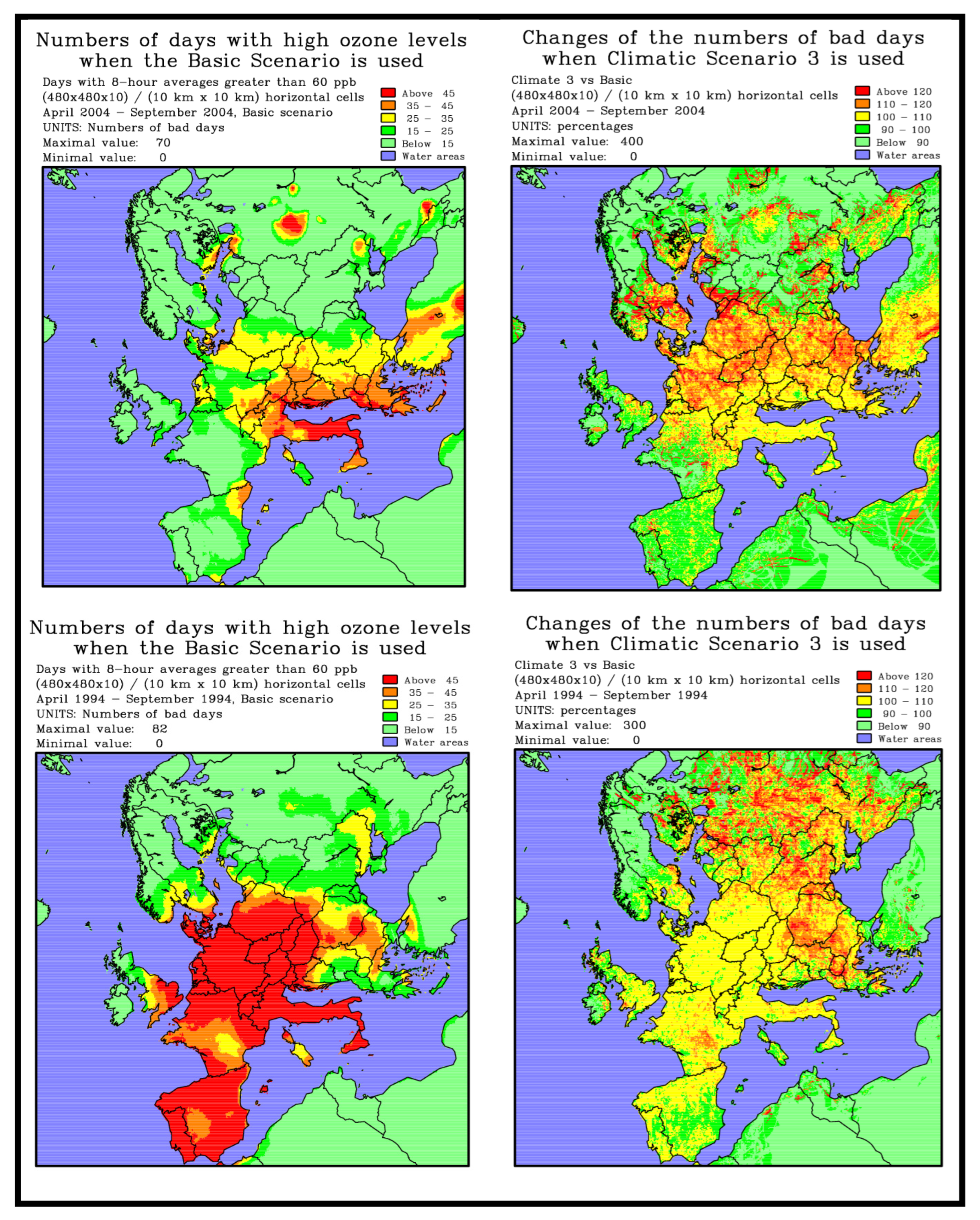
Some results showing the distribution of the “bad days” in Europe are given in Figure 3. Three important conclusions can be drawn from this figure:
(a)
It can be seen that both the distribution of the “bad days” in the different parts of Europe and the numbers of the “bad days” can vary very much from one year to another year (compare the two left-hand-side plots in Figure 3 where the results from the Basic Scenario are given for years 1994 and 2004).
(b)
The application of the Third Climatic Scenario is normally resulting in an increase of the numbers of “bad days”. The changes can be very significant (see the right-hand side plots where the increases, in percent, of the numbers of “bad days” are given for the two selected years).
(c)
In many parts of Europe, the numbers of “bad days” are considerable larger than the prescribed limit of 25 days.

4.2. Variation of the Numbers of “Bad Days” in Several Major Cities in Europe

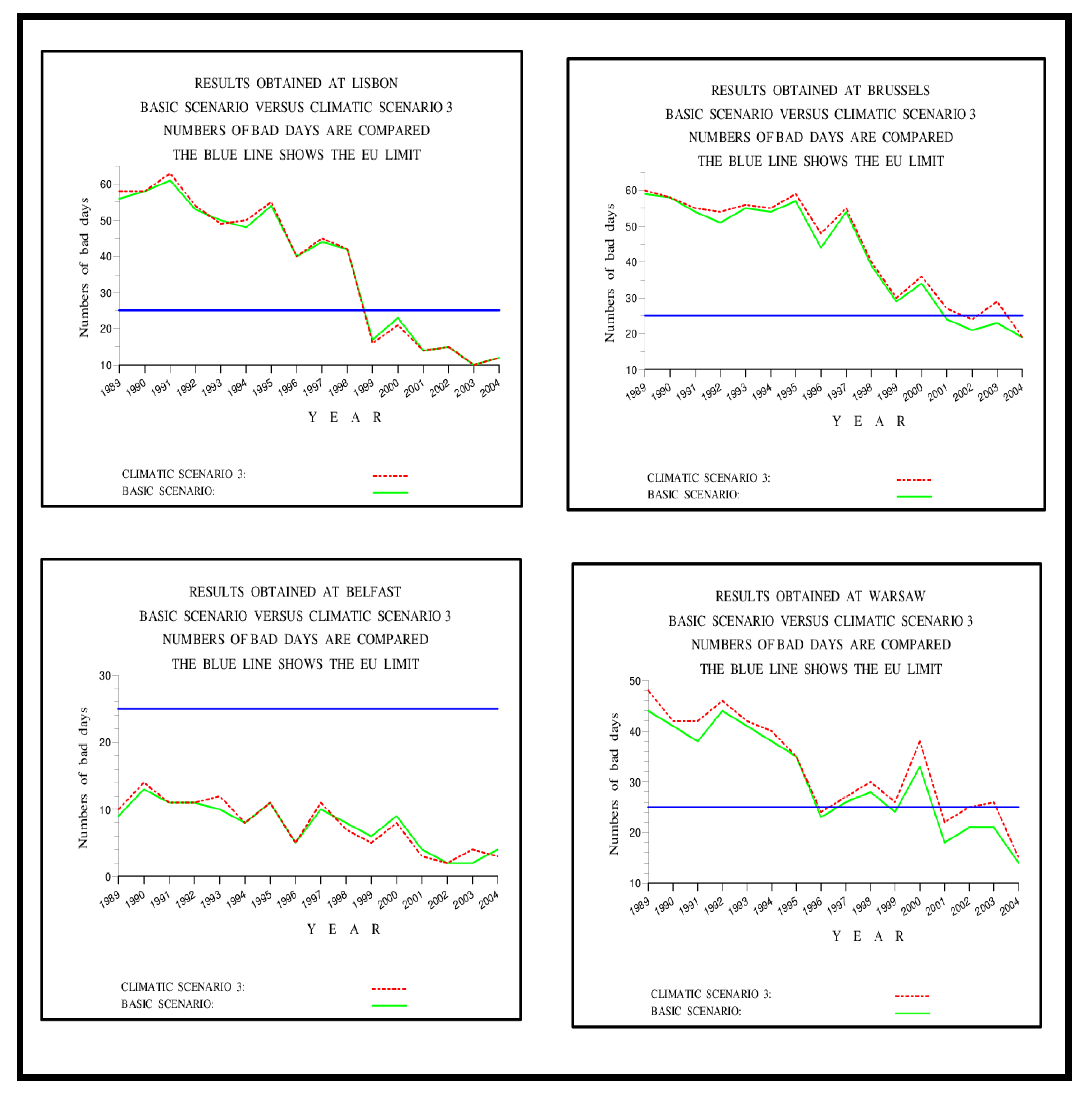
Some results showing the variation of the “bad days” in eight cities located in different parts of the continent are given in Figure 4 and Figure 5. Several important conclusions can be drawn from these plots:
(a)
The numbers of the “bad days” are as a rule decreasing at the end of the period of sixteen years. However, this is not always the case; see the results for Naples and Stockholm.
(b)
The numbers of “bad days” are very often greater (and even much greater) than the limit of 25. At some of the cities, as Innsbruck and Naples, this is true for all 16 years.
(c)
The results for Belfast and Stockholm indicate that the numbers of “bad days” is staying under or close to 25 in the regions far to the West and to the North. The same conclusion can also be seen for the two selected years (1994 and 2004) in the plots in Figure 3.
It should be pointed out that the above conclusions hold also for many other cities in Europe (see, for example, [13,15,16,17,21,22,23,26,28]).

4.3. Influence of the Natural (Biogenic) Emissions on Pollution Levels in Europe

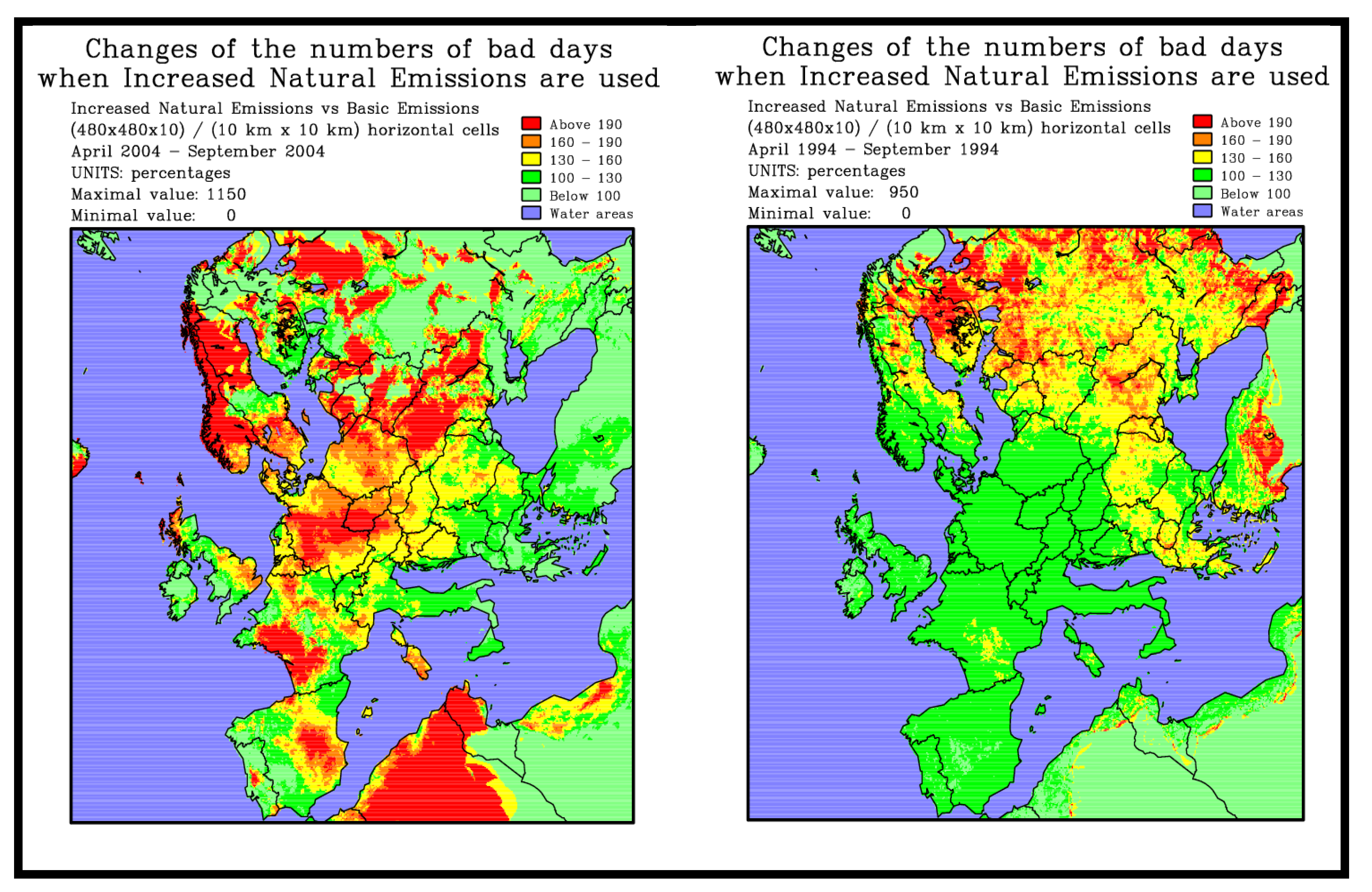
Some results obtained in the surface domain of UNI-DEM by using the scenario from Section 3.5, which is related to the influence of the natural (biogenic) emissions on ozone levels in Europe are given in Figure 6.
The results in the two plots of Figure 6 indicate that the situation can change very much from a given part of Europe to another part of the continent. The changes can also be very considerable in the transition from one year to another year.
The common trend is that the increase of the biogenic (natural) emissions based on the assumptions made in [42] leads to great increases of the numbers of “bad days” in many parts of Europe.

5. Influence of the Climatic Changes on Pollution Levels in Bulgaria

It is possible to use DIGITAL AIR in connection with any part of Europe. Now we shall concentrate our attention on a domain of the South-Eastern Europe, which contains Bulgaria and parts of its surrounding countries. The same approach, as that applied in the previous section, will be used in the presentation of the results. We shall discuss:
(a)
the distribution of the “bad days” in the chosen domain,
(b)
the occurrences of “bad days” in several Bulgarian towns,
(c)
and the increases of the numbers of “bad days” when the scenario with increased natural (biological) emissions is applied.

5.1. Distribution of the “Bad Days” in the Area Containing Bulgaria and its Surroundings

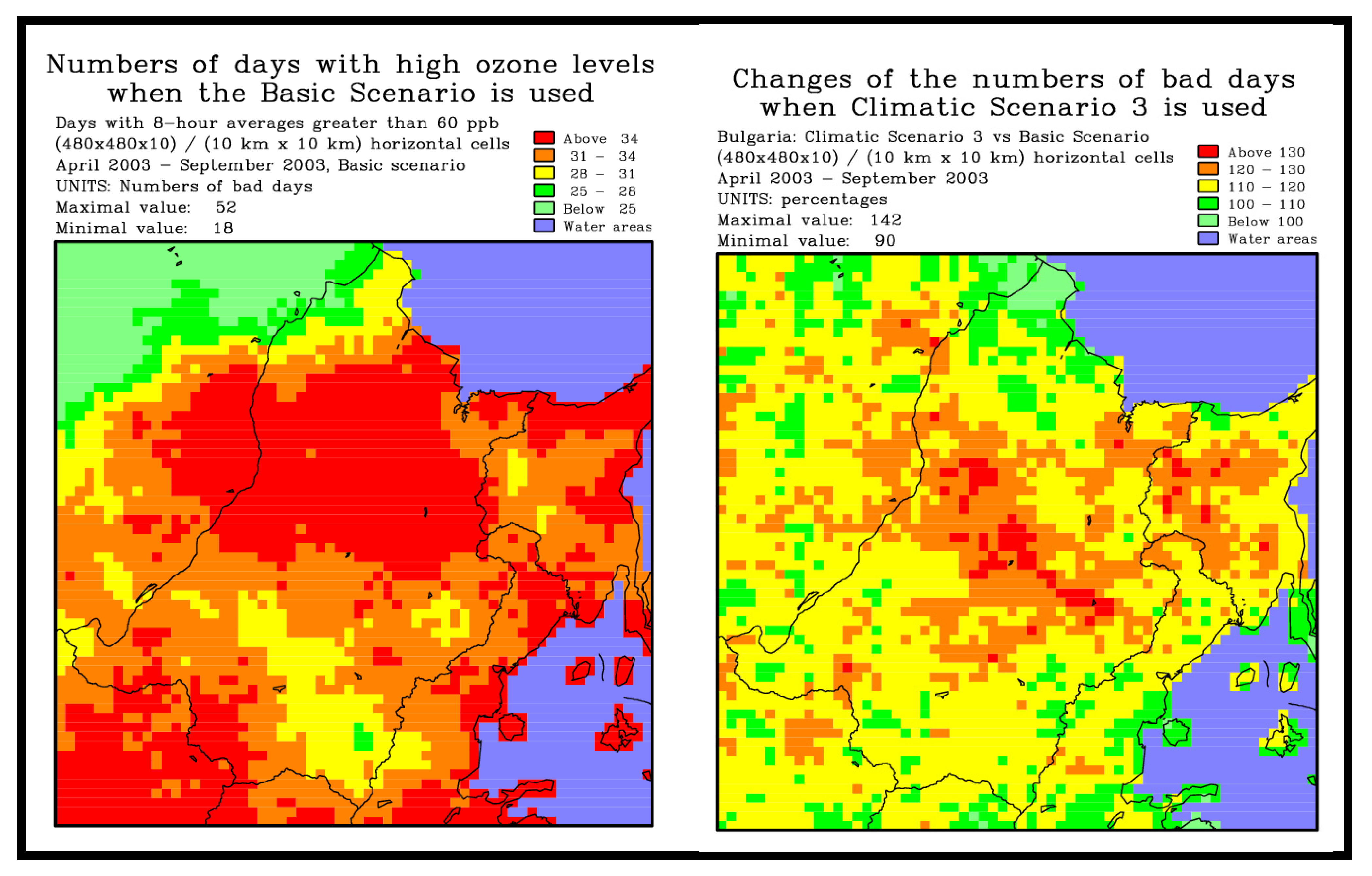
The distribution of the “bad days” on the Bulgarian territory in years 2003 and 1993 is given in Figure 7 (some impression about the distribution of the “bad days” in years 2004 and 1994 in this area can also be obtained by studying the plots in Figure 3). The main conclusions are the same as these made in Section 4.1:
(a)
Both the distribution of the “bad days” in the different parts of Bulgaria and the numbers of the “bad days” can vary very much from one year to another year (compare the two left-hand-side plots in Figure 7 where the results from the Basic Scenario are given for years 1993 and 2003).
(b)
The application of the Third Climatic Scenario is normally resulting in an increase of the numbers of “bad days”. The changes can be very significant (see the right-hand side plots in Figure 7, where the increases, in percent, of the numbers of “bad days” are given for the two selected years). It is also seen that the changes for 2003 are in general greater than the corresponding changes for 1993.
(c)
The numbers of “bad days” are often larger than the prescribed limit of 25 days.

5.2. Variation of the Numbers of “Bad Days” in Several Bulgarian Towns

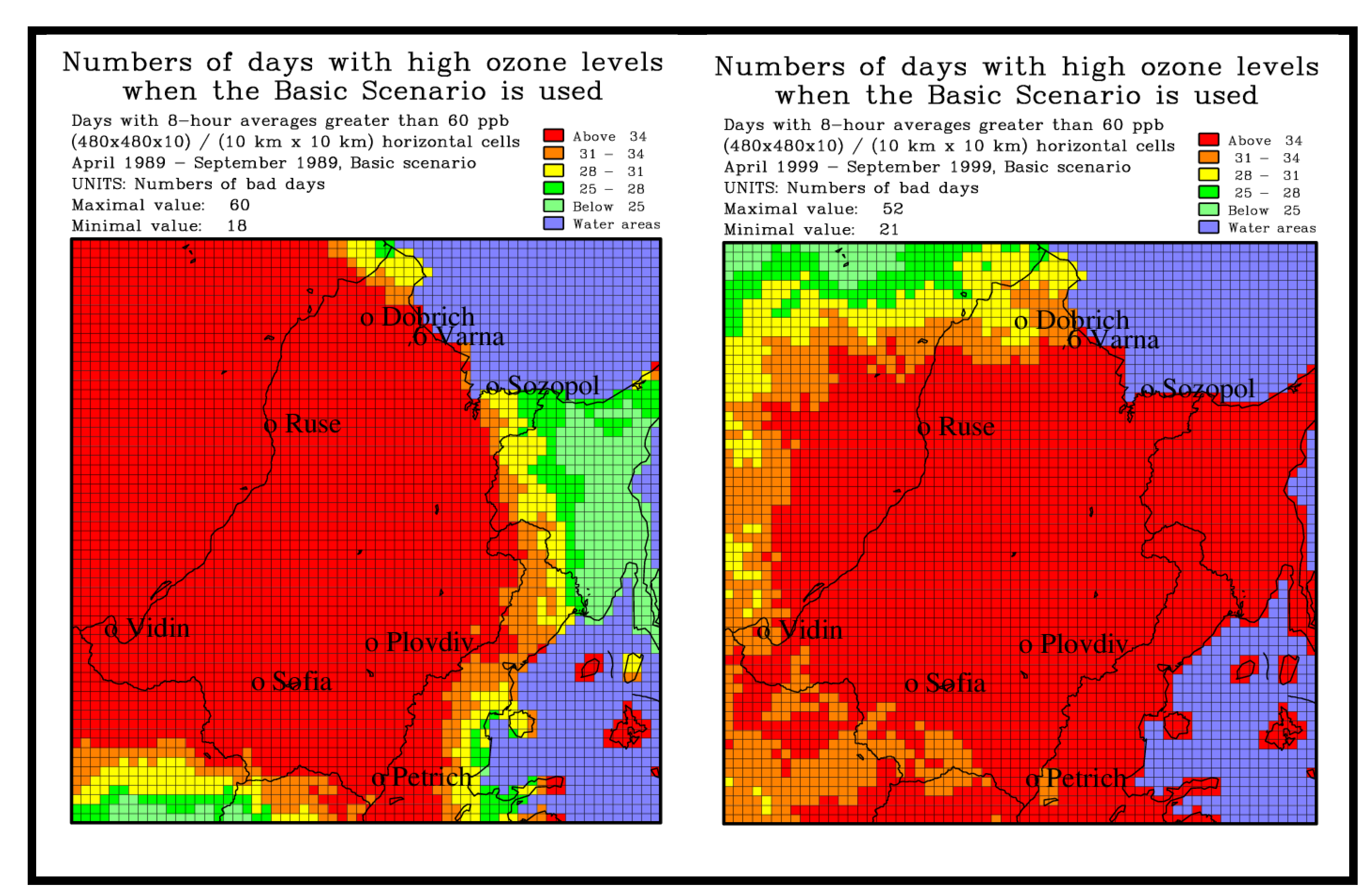
As in Section 4, eight towns were chosen. These towns are shown in Figure 8. The numbers of “bad days” in 1989 and in 1999 are also given in Figure 8. It is seen that these numbers are rather high.
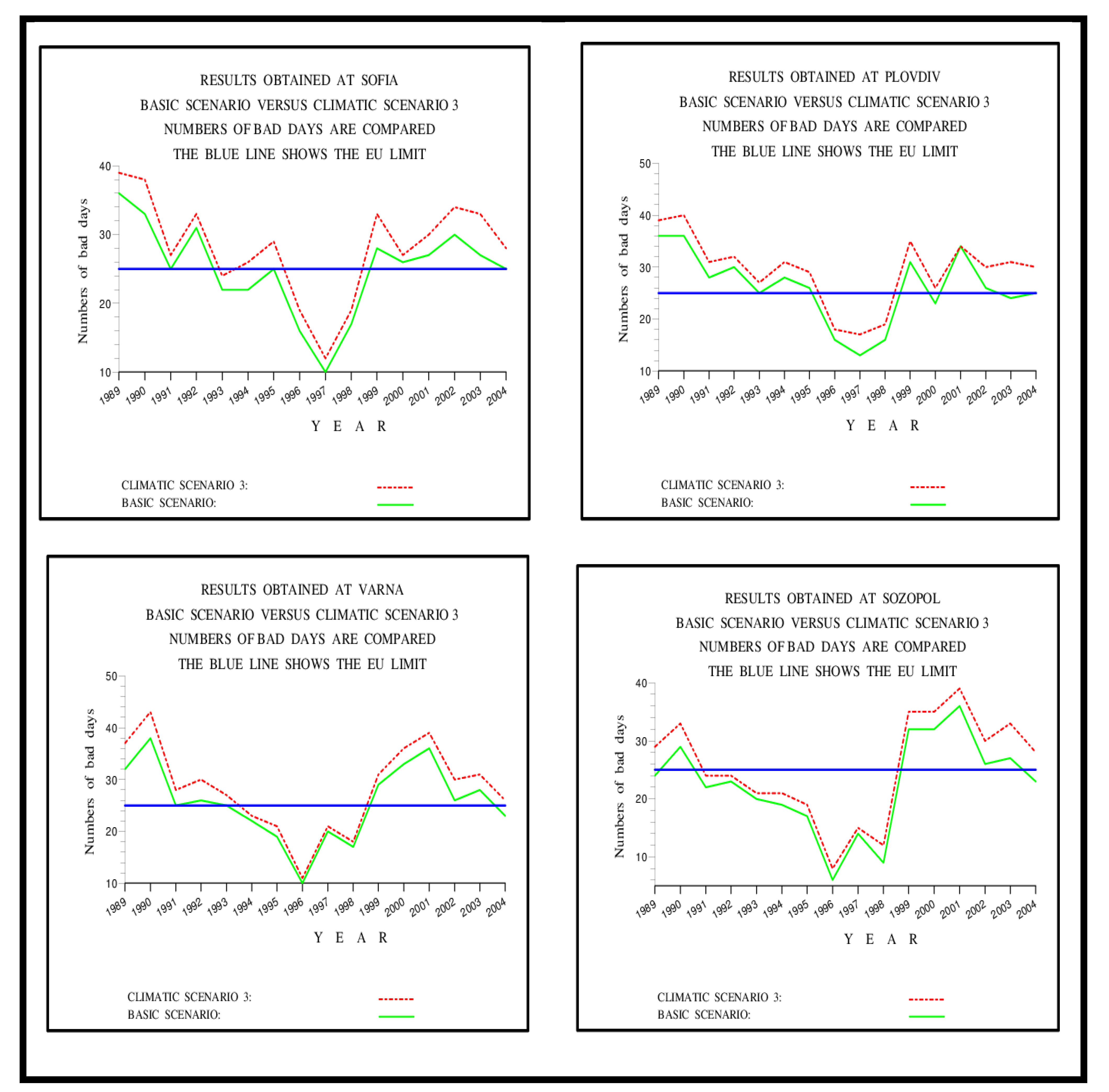
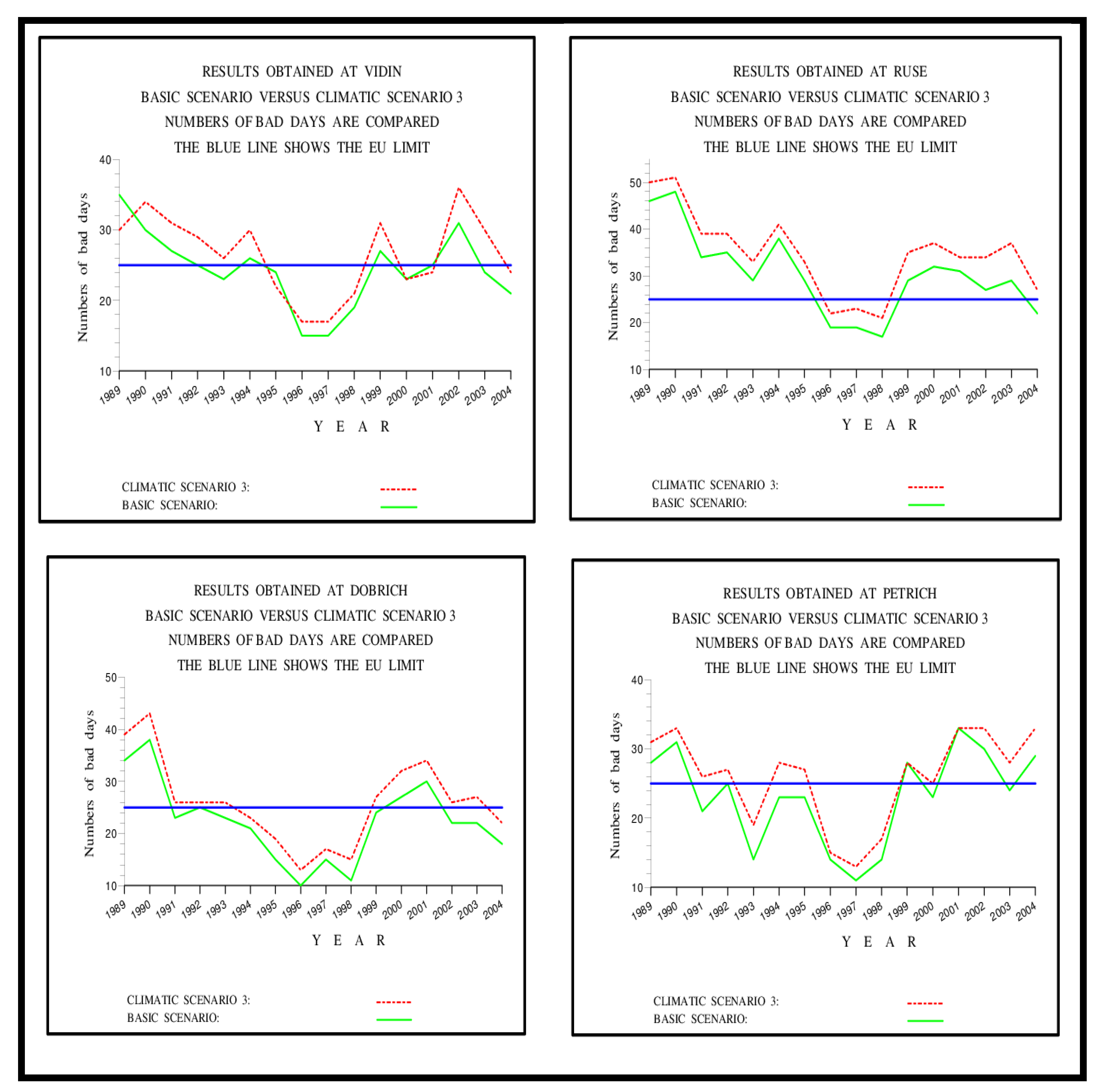
Curves showing the variations of the numbers of “bad days” in the selected place Bulgarian towns are given in Figure 9 and Figure 10. Several important conclusions can be drawn from these plots:
(a)
The numbers of the “bad days” are as a rule decreasing at the middle of the period of 16 years. It is not very clear what the reason for this behaviour is.
(b)
The numbers of “bad days” are often greater than the limit of 25.
(c)
It should be pointed the above conclusions holds also for many other cities in Europe (see, for example, [13,14,15,16,17,21,22,23]).

5.3. Influence of the Natural (Biogenic) Emissions on Pollution Levels in Bulgaria

Some results obtained in the surface domain of UNI-DEM by using the scenario from Section 3.5, which is related to the influence of the natural (biogenic) emissions on ozone levels in Bulgaria and its surroundings, are given in Figure 11. It is seen that the harmful levels of the ozone concentrations are smaller than the corresponding levels in many other countries of Europe. However, the exceeding of the ozone concentrations is anyway considerably higher than the prescribed limit of 25 “bad days”. It must be emphasized too that this is also true for all other years from the chosen interval between 1989 and 2004.

6. Discussion and Concluding Remarks

Several conclusions, which are obtained by using DIGITAL AIR and related (a) to the numbers of “bad days”, (b) to the huge computational difficulties and (c) to the development and implementation of relevant climatic scenarios, are given in the next three subsections. The major conclusions are drawn in Section 6.4.

6.1. The “Bad Days”

Three important issues based on the results presented in the previous two sections, are drawn below.
(a)
The numbers of “bad days” can be larger than the limit of 25 days, both in many regions of Europe and in many places of Bulgaria. People suffering from asthmatic deceases will have difficulties during the long periods with such days. Therefore, it is advisable to take the needed measures for the reduction of the long periods of “bad days”.
(b)
It is highly desirable to develop devices for predicting the coming of periods of “bad days” in a reliable way. If this is done, then the responsible authorities should take care to inform in a good time the people with asthmatic diseases for the coming danger.
(c)
Some further research about the effects of long sequences of “bad days” on people with asthmatic deceases will also very be very useful.

6.2. The Computational Difficulties

It should be mentioned here that it was very difficult to handle numerically the mathematical model described in Section 2, the Unified Danish Eulerian Model (UNI-DEM), and to calculate the results presented in Section 4 and Section 5. There are several reasons for that:
(a)
The amount of the input data (both meteorological data and emission data) is enormous. Moreover, it is necessary to apply reliable data sets of input data. Such data sets were obtained from the EMEP database [1,40,41], included in DIGITAL AIR and used in all runs. The sets of output data, which have to be preserved and analysed, are also extremely big.
(b)
It is necessary to apply fine discretization, especially in the efforts to obtain reliable information about small European countries (as, for example, Bulgaria and Hungary). Therefore, (10 km × 10 km) cells are to be used. The computational work needed to calculate the desired information is enormous. This was explained in Section 2. The difficult computational problems were resolved by applying the efficient numerical methods discussed in [14,26].
(c)
However, the use of efficient numerical methods is by no means enough. It was also necessary to run UNI-DEM on powerful and fast parallel computers. The BLUE GENE computer in Sofia was used in many of the runs.

6.3. The Climatic Scenarios

It was also necessary to develop several climatic scenarios, to include these scenarios (together with many other scenarios) in DIGITAL AIR and to use these scenarios many times in the runs of UNI-DEM. Thus, the climatic scenarios are also an essential and very important part of DIGITAL AIR. Information from the reports written by the specialists from the International Panel for Climate Changes (IPCC) was used in the preparation of the climatic scenarios. Fourteen climatic scenarios were being developed and included in DIGITAL AIR, but only five of these scenarios were used in this study. We applied only the information, which is relevant for the study of the high ozone levels in Europe and run UNI-DEM with the chosen scenarios in order to show that following statements are correct:
(a)
The climatic changes will lead to a considerable increase of the ozone concentrations. These high levels may have damaging effects on some groups of human beings.
(b)
No increases or small increases only of the ozone concentrations were detected in the parts of Europe, which are located far to the North and far to the West (mostly in Northern Ireland and in the Northern parts of Scandinavia, Finland and the Russian Federation).
(c)
The increases of the dangerous ozone concentrations in Bulgaria are not as high as the increases in some countries in Central and Southern Europe, such as Germany and Italy, but these increases can nevertheless have very damaging effects on some groups of human beings.

6.4. Conclusions

The use of a precisely-prepared Digital Twin, the DIGITAL AIR, to study the appearance of high ozone levels in different parts of Europe was discussed in the previous sections. We studied the possible changes of the ozone pollution levels in different parts of Europe and Bulgaria by applying the following tools:
(a)
A mathematical model, UNI-DEM, which must be handled by using efficient and accurate numerical algorithms on fast modern supercomputers.
(b)
Many large sets of input data (and first and foremost meteorological data, emission data and geographical data).
(c)
A set of carefully prepared climatic scenarios describing both the increase of the temperature in the future and the increase of the natural (biogenic) emissions.
(d)
Many graphical programs, by which the obtained numerical results can be visualized.
It is shown that the future climatic changes will very often result in an increase of the dangerous ozone levels in many sites of Europe and Bulgaria during the summer periods. This can cause problems for people who are suffering from asthmatic diseases.
With regard to future plans, we intend to conduct similar research by applying DIGITAL AIR, not only for the Bulgarian high ozone levels but also for the ozone levels in any European country. Some results for Denmark, Hungary and the countries in the Balkan Peninsula were presented in [17,21,23]. DIGITAL AIR can also be used to study other potentially dangerous pollution levels (as, for example, pollution levels caused by SO 2 and NO x emissions, see [23]).

Author Contributions

Conceptualization, Z.Z. and I.D.; Investigation, I.D.; Methodology, Z.Z. and I.D.; Resources, Z.Z.; Writing—original draft, Z.Z. All authors have read and agreed to the published version of the manuscript.

Funding

This research was funded by the Bulgarian Science Fund, grant number DFNI KP-06-N52/5.

Institutional Review Board Statement

Not applicable.

Informed Consent Statement

Not applicable.

Data Availability Statement

Not applicable.

Conflicts of Interest

The authors declare no conflict of interest.

References

  1. Hass, H.; Ebel, A.; Feldmann, H.; Jakobs, H.; Memmesheimer, M. Evaluation studies with a regional chemical transport model (EURAD) using air quality data from the EMEP monitoring network. Atmos. Environ. Part A Gen. Top. 1993, 27, 867–887. [Google Scholar] [CrossRef]
  2. Balogun, A.-L.; Marks, D.; Sharma, R.; Shekhar, H.; Balmes, C.; Maheng, D.; Arshad, A.; Salehi, P. Assessing the Potentials of Digitalization as a Tool for Climate Change Adaptation and Sustainable Development in Urban Centres. Sustain. Cities Soc. 2020, 53, 101888. [Google Scholar] [CrossRef]
  3. Bauer, P.; Stevens, B.; Hazeleger, W. A digital twin of Earth for the green transition. Nat. Clim. Chang. 2021, 11, 80–83. [Google Scholar] [CrossRef]
  4. Costantini, A.; Di Modica, G.; Ahouangonou, J.C.; Duma, D.C.; Martelli, B.; Galletti, M.; Antonacci, M.; Nehls, D.; Bellavista, P.; Delamarre, C.; et al. IoTwins: Toward Implementation of Distributed Digital Twins in Industry 4.0 Settings. Computers 2022, 11, 67. [Google Scholar] [CrossRef]
  5. Dembski, F.; Wössner, U.; Letzgus, M.; Ruddat, M.; Yamu, C. Urban Digital Twins for Smart Cities and Citizens: The Case Study of Herrenberg, Germany. Sustainability 2020, 12, 2307. [Google Scholar] [CrossRef] [Green Version]
  6. Dwivedi, Y.K.; Hughes, L.; Kar, A.K.; Baabdullah, A.M.; Grover, P.; Abbas, R.; Andreini, D.; Abumoghli, I.; Barlette, Y.; Bunker, D.; et al. Climate change and COP26: Are digital technologies and information management part of the problem or the solution? An editorial reflection and call to action. Int. J. Inf. Manag. 2021, 63, 102456. [Google Scholar] [CrossRef]
  7. Houghton, J.T.; Ding YD, J.G.; Griggs, D.J.; Noguer, M.; van der Linden, P.J.; Dai, X.; Maskell, K.; Johnson, C.A. Climate Change 2001: The Scientific Basis; Cambridge University Press: Cambridge, UK; New York, NY, USA, 2001. [Google Scholar]
  8. Nativi, S.; Mazzetti, P.; Craglia, M. Digital Ecosystems for Developing Digital Twins of the Earth: The Destination Earth Case. Remote Sens. 2021, 13, 2119. [Google Scholar] [CrossRef]
  9. Pedersen, A.; Borup, M.; Brink-Kjær, A.; Christiansen, L.; Mikkelsen, P. Living and Prototyping Digital Twins for Urban Water Systems: Towards Multi-Purpose Value Creation Using Models and Sensors. Water 2021, 13, 592. [Google Scholar] [CrossRef]
  10. Peters, L.K.; Berkowitz, C.M.; Carmichael, G.R.; Easter, R.C.; Fairweather, G.; Ghan, S.J.; Hales, J.M.; Leung, L.R.; Pennell, W.R.; Potra, F.A.; et al. The current state and future direction of Eulerian models in simulating the tropospheric chemistry and transport of trace species: A review. Atmos. Environ. 1995, 29, 189–222. [Google Scholar] [CrossRef]
  11. Zannetti, P. Air Pollution Modelling: Theories, Computational Methods and Available Software; Springer Science and Business Media: New York, NY, USA, 1990. [Google Scholar] [CrossRef]
  12. Zlatev, Z. Computer Treatment of Large Air Pollution Models; Kluwer Academic Publishers: Dordrecht, The Netherlands, 1995. [Google Scholar] [CrossRef]
  13. Zlatev, Z.; Dimov, I. Computational and Numerical Challenges in Environmental Modelling; Elsevier: Amsterdam, The Netherlands, 2006. [Google Scholar] [CrossRef]
  14. Zlatev, Z.; Dimov, I.; Farago, I.; Georgiev, K.; Havasi, A. Large-scale air pollution modeling in Europe under different climatic scenarios. Int. J. Big Data Min. Glob. Warm. 2019, 1, 1950009. [Google Scholar] [CrossRef]
  15. Zlatev, Z.; Dimov, I.; Georgiev, K. Relations between Climatic Changes and High Pollution Levels in Bulgaria. Open J. Appl. Sci. 2016, 06, 386–401. [Google Scholar] [CrossRef] [Green Version]
  16. Zlatev, Z.; Faragó, I.; Havasi, Á. Impact of Climatic Changes on Pollution Levels. In Mathematical Problems in Meteoro-Logical; Series on “Mathematics in Industry”; Bátkai, A., Csomós, P., Faragó, I., Horányi, A., Szépszó, G., Eds.; Springer: Berlin/Heidelberg, Germany, 2016; Volume 24, pp. 129–161. Available online: https://www.semanticscholar.org/paper/Impact-of-Climatic-Changes-on-Pollution-Levels-Zlatev-Farag%C3%B3/4539573cdff40c8831c87f9be05e460aea449fcf (accessed on 1 June 2022).
  17. Zlatev, Z.; Georgiev, K.; Dimov, I. Influence of climatic changes on pollution levels in the Balkan Peninsula. Comput. Math. Appl. 2013, 65, 544–562. [Google Scholar] [CrossRef]
  18. IPCC Climate Change. The Physical Science Basis. Contribution of the Working Group I to the Fourth Assessment Report of IPCC. Intergovernmental Panel on Climate Change; Cambridge University Press: Cambridge, UK; New York, NY, USA, 2007; Volume 996, pp. 113–119. [Google Scholar]
  19. Jacobson, M.Z. On the causal link between carbon dioxide and air pollution mortality. Geophys. Res. Lett. 2008, 35. [Google Scholar] [CrossRef] [Green Version]
  20. Vrchota, J.; Pech, M.; Rolínek, L.; Bednář, J. Sustainability Outcomes of Green Processes in Relation to Industry 4.0 in Manufacturing: Systematic Review. Sustainability 2020, 12, 5968. [Google Scholar] [CrossRef]
  21. Zlatev, Z.; Moseholm, L. Impact of climate changes on pollution levels in Denmark. Ecol. Model. 2008, 217, 305–319. [Google Scholar] [CrossRef]
  22. Zlatev, Z.; Syrakov, D. A fine-resolution modelling study of pollution levels in Bulgaria. Part 1: SO2 and NO2 pollution. Int. J. Environ. Pollut. 2004, 22, 186–202. [Google Scholar] [CrossRef]
  23. Zlatev, Z.; Syrakov, D. A fine-resolution modelling study of pollution levels in Bulgaria. Part 2: High ozone levels. Int. J. Environ. Pollut. 2004, 22, 203–222. [Google Scholar] [CrossRef]
  24. Ostromsky, T.Z.; Todorov, V.; Dimov, I.; Georgieva, R.; Zlatev, Z.; Poryazov, S. Sensitivity Study of Large-Scale Air Pollution Model Based on Modifications of the Latin Hypercube Sampling Method. In Lecture Notes in Computer Science; Springer: Cham, Switzerland, 2022; pp. 156–163. [Google Scholar]
  25. Todorov, V.; Dimov, I.; Ostromsky, T.; Apostolov, S.; Georgieva, R.; Dimitrov, Y.; Zlatev, Z. Advanced stochastic approaches for Sobol’ sensitivity indices evaluation. Neural Comput. Appl. 2020, 33, 1999–2014. [Google Scholar] [CrossRef]
  26. Zlatev, Z. Impact of future climatic changes on high ozone levels in European suburban areas. Clim. Chang. 2009, 101, 447–483. [Google Scholar] [CrossRef]
  27. Ackermann, I.J.; Hass, H.; Schell, B.; Binkowski, F.S. Regional modelling of particulate matter with MADE. Environ. Manag. Health 1999, 10, 201–208. [Google Scholar] [CrossRef] [Green Version]
  28. Bell, M.L.; Goldberg, R.; Hogrefe, C.; Kinney, P.L.; Knowlton, K.; Lynn, B.; Rosenthal, J.; Rosenzweig, C.; Patz, J.A. Climate change, ambient ozone, and health in 50 US cities. Clim. Chang. 2007, 82, 61–76. [Google Scholar] [CrossRef]
  29. Borrell, P.; Borrell, P.M.; Seiler, W.; Csitas, T. Transport and Transformation of Pollutants in the Troposphere; Springer: Berlin, Germany, 2000. [Google Scholar] [CrossRef]
  30. Carmichael, G.R.; Peters, L.K. An Eulerian transport/transformation/removal model for SO2 and Sulphate—I. Model development. Atmos. Environ. 1984, 18, 937–951. [Google Scholar] [CrossRef]
  31. Carmichael, G.R.; Peters, L.K. A second generation model for regional-scale transport/chemistry/deposition. Atmos. Environ. 1986, 20, 173–188. [Google Scholar] [CrossRef]
  32. Chang, J.S.; Brost, R.A.; Isaksen, I.S.A.; Madronich, S.; Middleton, P.; Stockwell, W.; Walcek, C.J. A three-dimensional Eulerian acid deposition model: Physical concepts and formulation. J. Geophys. Res. Earth Surf. 1987, 92, 14681–14700. [Google Scholar] [CrossRef]
  33. Ebel, A.; Memmesheimer, M.; Jakobs, H.J. Regional Modelling of Tropospheric Ozone Distributions and Budgets. In Atmospheric Ozone Dynamics: I. Global Environmental Change; NATO ASI Series; Varotsos, C.C., Ed.; Springer: Berlin/Heidelberg, Germany, 1997; Volume 53, pp. 37–57. ISBN 978-3-642-60797-4. [Google Scholar]
  34. Hass, H.; Jakobs, H.J.; Memmesheimer, M. Analysis of a regional model (EURAD) near surface gas concentration predictions using observations from networks. Meteorol. Atmos. Phys. 1995, 57, 173–200. [Google Scholar] [CrossRef]
  35. Hou, L.; Wu, S.; Zhang, G.; Tan, Y.; Wang, X. Literature Review of Digital Twins Applications in Construction Workforce Safety. Appl. Sci. 2021, 11, 339. [Google Scholar] [CrossRef]
  36. Klippel, A.; Sajjadi, P.; Zhao, J.; Wallgrün, J.O.; Huang, J.; Bagher, M.M. Embodied digital twins for environmental applications. ISPRS Ann. Photogramm. Remote Sens. Spat. Inf. Sci. 2021, 4, 193–200. [Google Scholar] [CrossRef]
  37. Simpson, D.; Guenther, A.; Hewitt, C.N.; Steinbrecher, R. Biogenic emissions in Europe: 1. Estimates and uncertainties. J. Geophys. Res. Earth Surf. 1995, 100, 22875–22890. [Google Scholar] [CrossRef] [Green Version]
  38. Stocker, T.F.; Qin, D.; Plattner, G.-K.; Tignor, M.; Allen, S.K.; Boschung, J.; Nauels, A.; Xia, Y.; Bex, V.; Midgley, P.M. (Eds.) Climate Change 2013: The Physical Basis; Contribution of the Working Group I of the Intergovernmental Panel on Climate Change; Cambridge University Press: Cambridge, UK; New York, NY, USA, 2013. [Google Scholar]
  39. Venkatram, A.; Karamchandani, P.; Misra, P. Testing a comprehensive acid deposition model. Atmos. Environ. 1988, 22, 737–747. [Google Scholar] [CrossRef]
  40. Working Group I to the Sixth Assessment Report of the Intergovernmental Panel on Climate Change; Masson-Delmotte, V.; Zhai, A.P.; Pirani, S.L.; Connors, C.; Péan, S.; Berger, N.; Caud, Y.; Chen, L.; Goldfarb, M.I.; et al. (Eds.) IPCC, 2021: Summary for Policymakers. In Climate Change 2021: The Physical Science Basis; Cambridge University Press: Cambridge, UK, 2021. [Google Scholar]
  41. Gery, M.W.; Whitten, G.Z.; Killus, J.P.; Dodge, M.C. A photochemical kinetics mechanism for urban and regional scale computer modeling. J. Geophys. Res. Earth Surf. 1989, 94, 12925–12956. [Google Scholar] [CrossRef]
  42. Anastasi, C.; Hopkinson, L.; Simpson, V. Natural hydrocarbon emissions in the United Kingdom. Atmos. Environ. Part A Gen. Top. 1991, 25, 1403–1408. [Google Scholar] [CrossRef]
  43. Stockwell, W.; Kirchner, F.; Kuhn, M.; Seefeld, S. A new mechanism for regional atmospheric chemistry modeling. J. Geophys. Res. Earth Surf. 1997, 102, 25847–25879. [Google Scholar] [CrossRef] [Green Version]
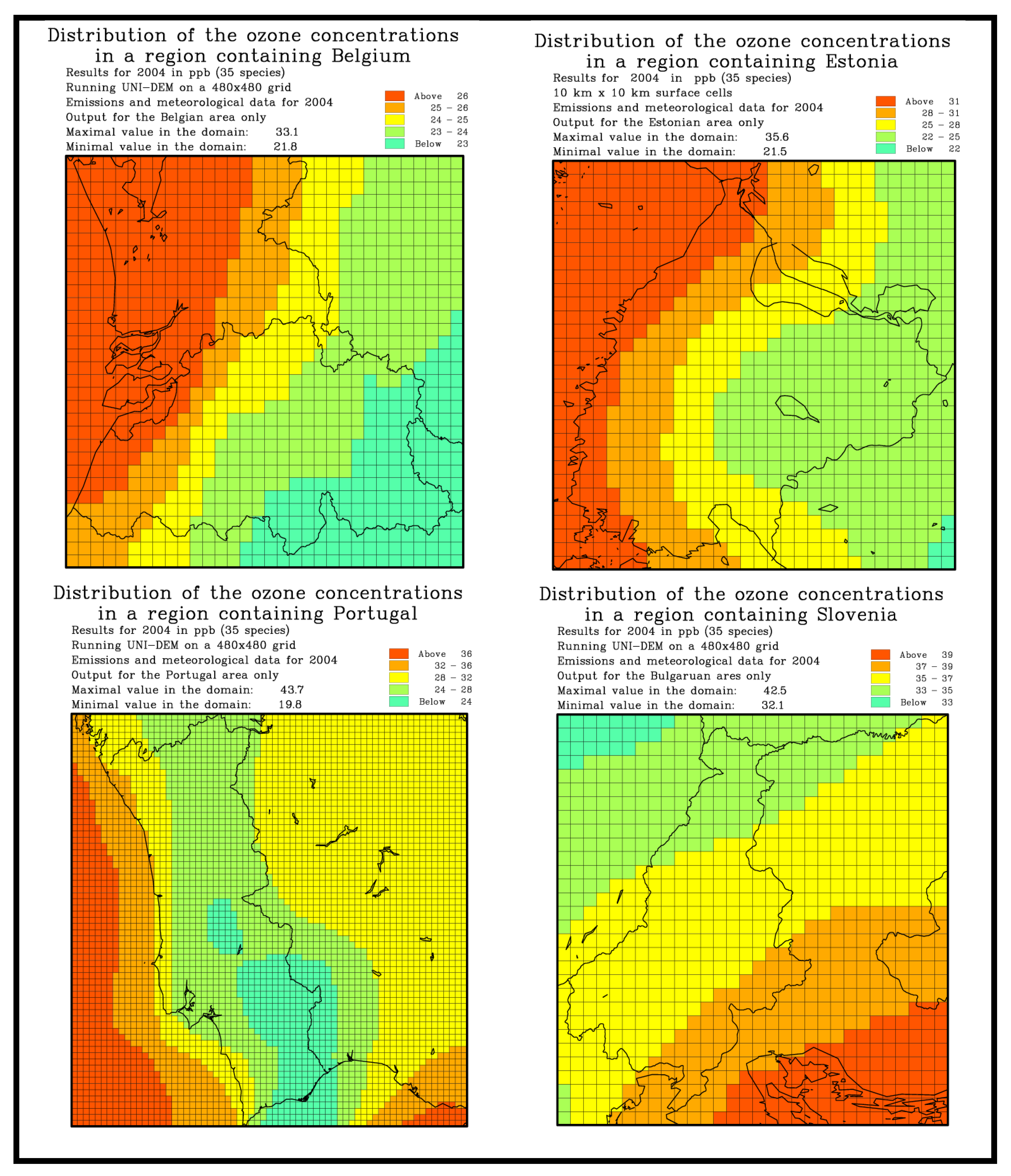
Figure 1. Mean ozone concentrations in four European countries (these plots demonstrate the ability of UNI-DEM to produce reliable results also for the small countries in Europe).
Atmosphere 13 00932 g001
Figure 2. Expected increases of the temperature in first horizontal level of the space domain of UNI-DEM according to the IPCC reports.
Atmosphere 13 00932 g002
Figure 3. Numbers of “bad days” in year 2004 (the upper left-hand-side plot) and in year 1994 (the lower left-hand-side plot). The corresponding increases (in percent) of the “bad days” when the Third Climatic Scenario is used are given in the two right-hand-side plots.
Atmosphere 13 00932 g003
Figure 4. Variations of the numbers of “bad days” in Innsbruck, Naples, London and Stockholm during a time-period of 16 consecutive years obtained when UNI-DEM is run with two scenarios. It is clear that the Third Climatic Scenario is consistently given more “bad days” than the Basic Scenario.
Atmosphere 13 00932 g004
Figure 5. Variations of the numbers of “bad days” in Lisbon, Brussels, Belfast and Warsaw during a time-period of 16 consecutive years obtained when UNI-DEM is run with two scenarios. The Third Climatic Scenario is again giving in most of the cases more “bad days” than the Basic Scenario.
Atmosphere 13 00932 g005
Figure 6. Increases (in percent) of the numbers of “bad days” in year 2004 (the left-hand-side plot) and in year 1994 (the right-hand-side plot) when the scenario with increased natural (biogenic) emissions is used. The numbers of “bad days” in these two years when the Basic Scenario is used are given in the left-hand-side plots of Figure 3.
Atmosphere 13 00932 g006
Figure 7. Results obtained in the sub-domain of UNI-DEM containing Bulgaria. Numbers of “bad days” in year 2003 (the upper left-hand-side plot) and in year 1993 (the lower left-hand-side plot). The increases when the third climatic scenario is used are given in the two right-hand-side plots.
Atmosphere 13 00932 g007aAtmosphere 13 00932 g007b
Figure 8. Results obtained in the subdomain of UNI-DEM containing Bulgaria. The grid-lines as well as colours presenting information about the numbers of “bad days” in year 1989 (the left-hand-side plot) and in year 1999 (the right-hand-side plot) are given in these two plots. It is seen that the numbers of “bad-days” in Bulgaria during these two years was higher than 34 (the red regions), i.e., higher than the limit of 25 “bad days”, in nearly the whole country. The names of the Bulgarian towns, which will be used in the next two figures, are also given in these two plots. It is seen that these towns are located in different parts of the country.
Atmosphere 13 00932 g008
Figure 9. Results obtained in four Bulgarian towns: Sofia, Plovdiv, Varna and Sozopol. The Third Climatic Scenario is consistently resulting in an increase of the numbers of “bad-days” when it is compared with the Basic Scenario.
Atmosphere 13 00932 g009
Figure 10. Results obtained in four Bulgarian towns: Vidin, Ruse, Dobrich and Petrich. It is clearly seen that also in this case the Third Climatic Scenario is consistently resulting in an increase of the numbers of “bad-days” when it is compared with the Basic Scenario.
Atmosphere 13 00932 g010
Figure 11. Increases (in percent) of the numbers of “bad days” in year 2003 (the left-hand-side plot) and in year 1993 (the right-hand-side plot) in a sub-domain containing Bulgaria when the scenario with increased natural (biogenic) emissions is used. The numbers of “bad days” in these two years when the Basic Scenario is used are given in the left-hand-side plots of Figure 7.
Atmosphere 13 00932 g011
Publisher’s Note: MDPI stays neutral with regard to jurisdictional claims in published maps and institutional affiliations.