Improving the Accuracy of Landsat 8 Land Surface Temperature in Arid Regions by MODIS Water Vapor Imagery
Abstract
1. Introduction
2. Materials and Methods
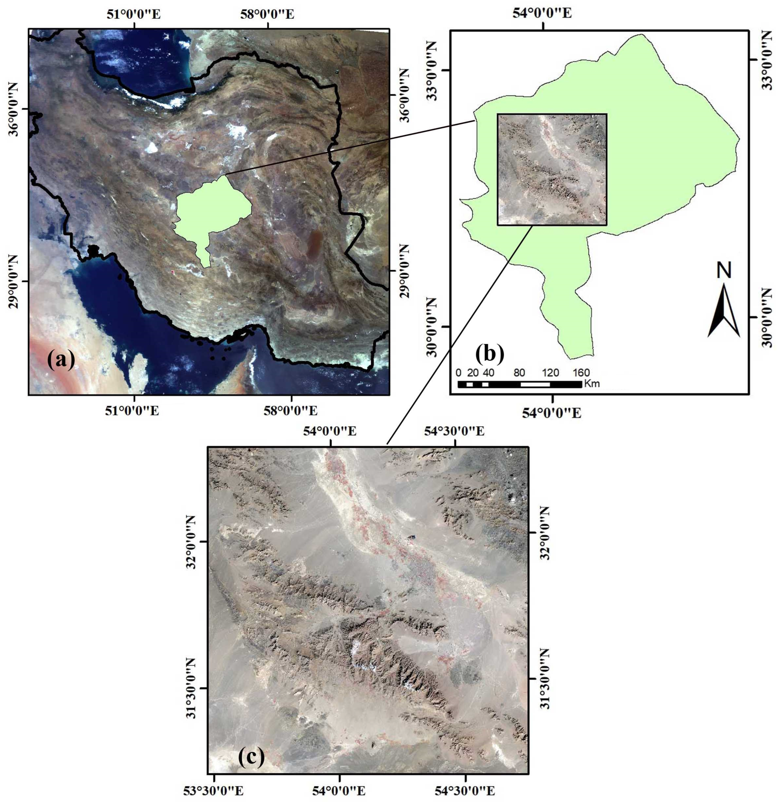
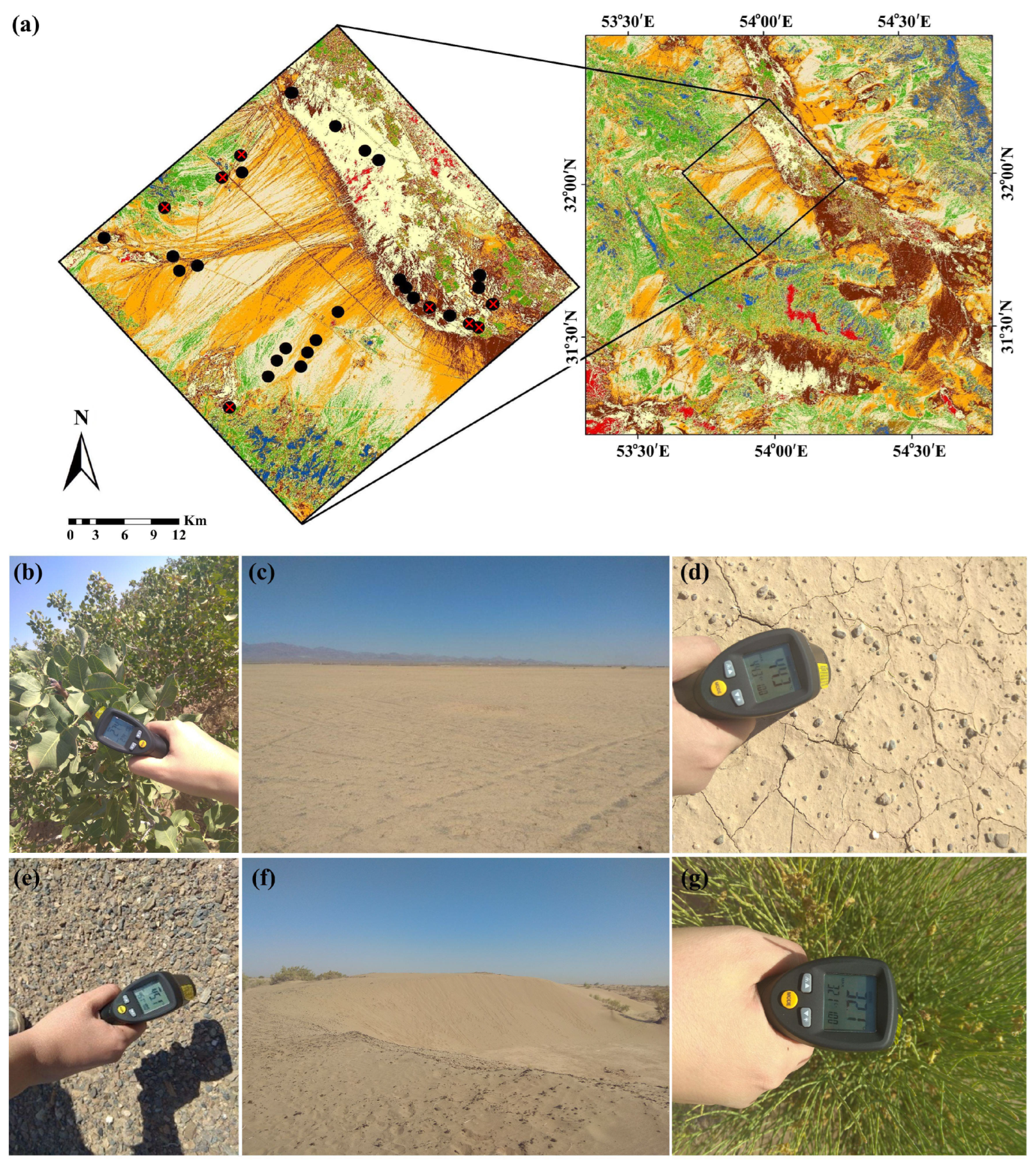
2.1. Study Area
2.2. Datasets and Preprocessings
2.2.1. Satellite Data
2.2.2. In Situ Data
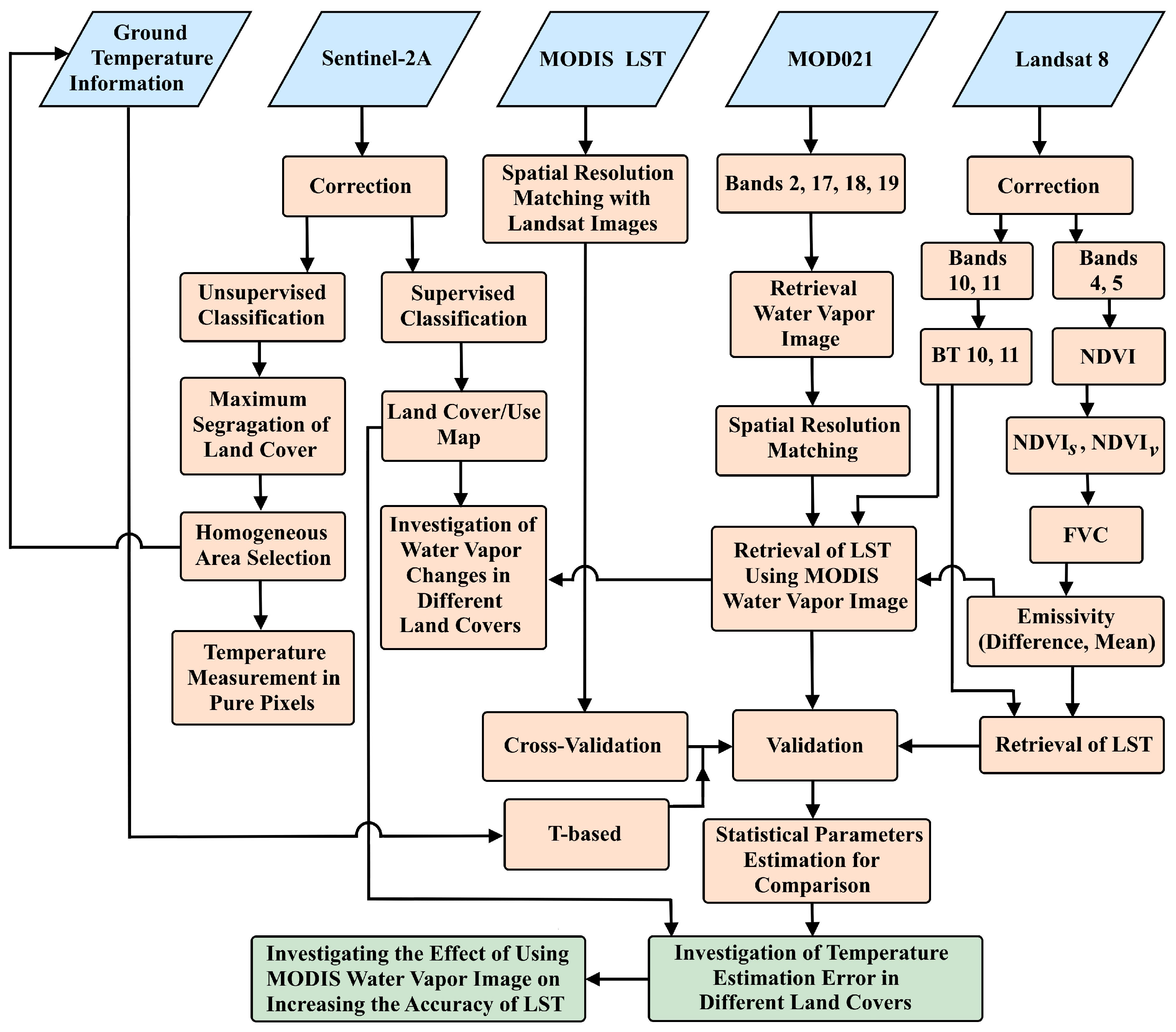
2.3. Methodology
2.3.1. Land Surface Temperature Estimation
2.3.2. Estimation of Water Vapor
2.3.3. Land Cover Classification
2.3.4. Validation of Land Surface Temperature
3. Results
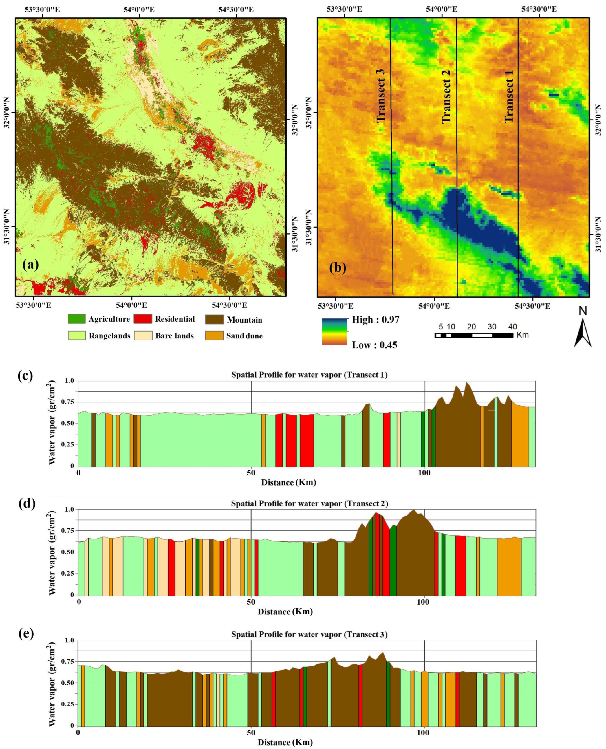
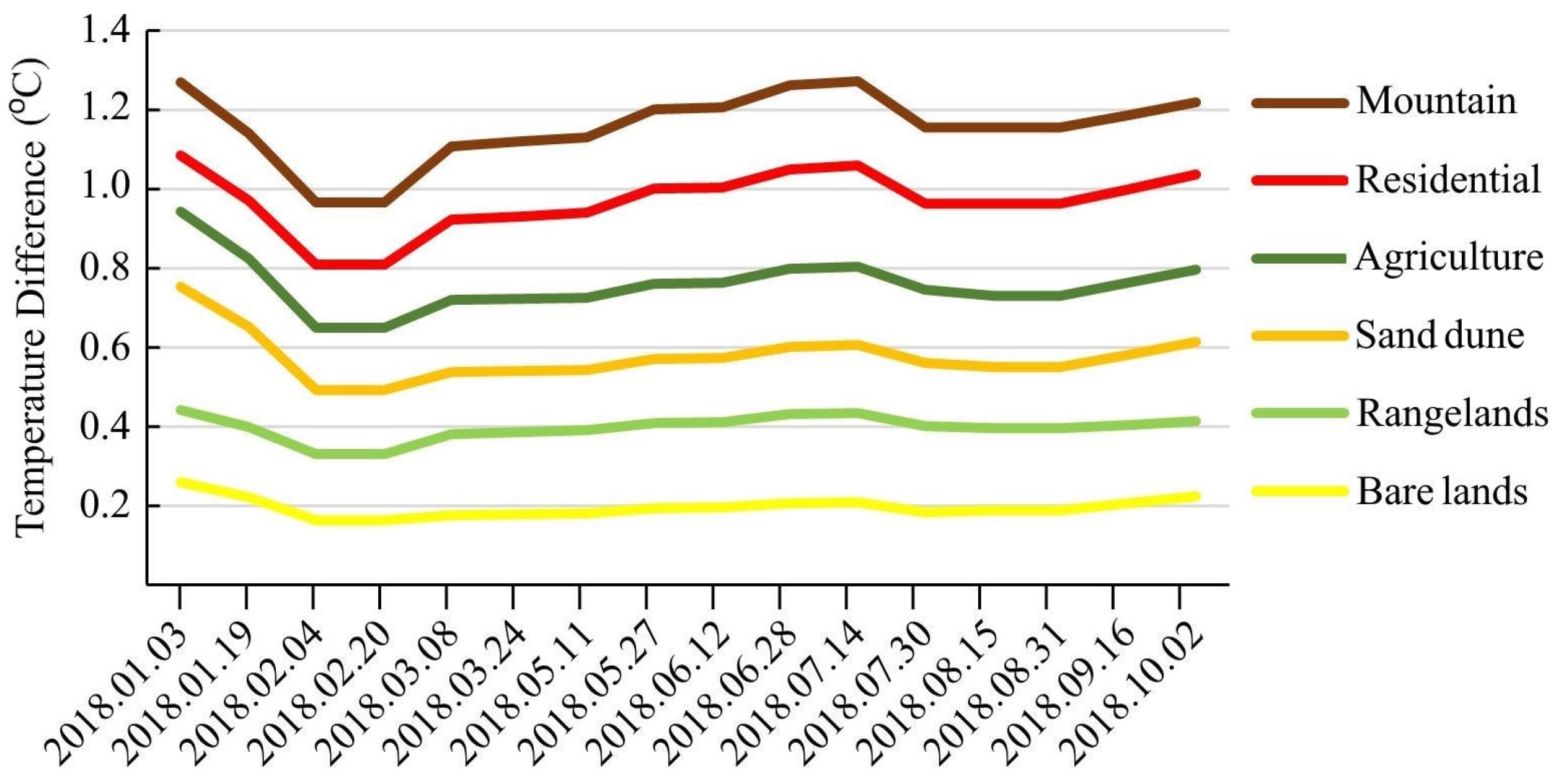
3.1. Investigating Atmospheric Water Vapor Changes in Different Land Covers and in Time Series
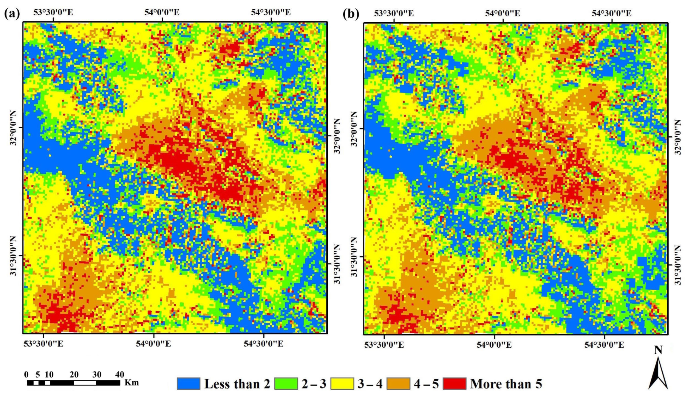
3.2. Validation of the Improved LST Method and Its Comparison with the Split Window Method
4. Discussion
5. Conclusions
Author Contributions
Funding
Data Availability Statement
Acknowledgments
Conflicts of Interest
Abbreviations
| AWV | Atmospheric Water Vapor |
| BT | Brightness Temperature |
| EUMETSAT | European Organization for the Exploitation of Meteorological Satellites |
| FVC | Fractional Vegetation Cover |
| LSE | Land Surface Emissivity |
| LST | Land Surface Temperature |
| MAD | Mean Absolute Differences |
| MODIS | Moderate Resolution Imaging Spectroradiometer |
| MSI | Multi-Spectral Instrument |
| NDVI | Normalized Difference Vegetation Index |
| NIR | Near Infrared |
| OLI | Operational Land Imager |
| RMSE | Root Mean Square Error |
| SD | Standard Deviation |
| SW | Split-Window |
| TIRS | Thermal Infrared Sensor |
| VZA | Viewing Zenith Angle |
References
- Weng, Q. Thermal infrared remote sensing for urban climate and environmental studies: Methods, applications, and trends. ISPRS J. Photogramm. Remote Sens. 2009, 64, 335–344. [Google Scholar] [CrossRef]
- Bisquert, M.; Sánchez, J.M.; López-Urrea, R.; Caselles, V. Estimating High Resolution Evapotranspiration from Disaggregated Thermal Images. Remote Sens. Environ. 2016, 187, 423–433. [Google Scholar] [CrossRef]
- Koc, C.B.; Osmond, P.; Peters, A. Spatio-temporal patterns in green infrastructure as driver of land surface temperature variability: The case of Sydney. Int. J. Appl. Earth Obs. Geoinf. 2019, 83, 101903. [Google Scholar]
- Guo, J.; Ren, H.; Zheng, Y.; Lu, S.; Dong, J. Evaluation of Land Surface Temperature Retrieval from Landsat 8/TIRS Images before and after Stray Light Correction Using the SURFRAD Dataset. Remote Sens. 2020, 12, 1023. [Google Scholar] [CrossRef]
- Wang, M.; He, G.; Zhang, Z.; Wang, G.; Wang, Z.; Yin, R.; Cao, X. A radiance-based split-window algorithm for land surface temperature retrieval: Theory and application to MODIS data. Int. J. Appl. Earth Obs. Geoinf. 2019, 76, 204–217. [Google Scholar] [CrossRef]
- Hale, R.C.; Gallo, K.P.; Tarpley, D.; Yu, Y. Characterization of variability at in situ locations for calibration/validation of satellite-derived land surface temperature data. Remote Sens. 2011, 2, 41–50. [Google Scholar]
- Ahmed, M.R.; Ghaderpour, E.; Gupta, A.; Dewan, A.; Hassan, Q.K. Opportunities and Challenges of Spaceborne Sensors in Delineating Land Surface Temperature Trends: A Review. IEEE Sens. J. 2023, 23, 6460–6472. [Google Scholar] [CrossRef]
- Ghaderpour, E.; Mazzanti, P.; Scarascia Mugnozza, G.; Bozzano, F. Coherency and phase delay analyses between land cover and climate across Italy via the least-squares wavelet software. Int. J. Appl. Earth Obs. Geoinf. 2023, 118, 103241. [Google Scholar] [CrossRef]
- Shawky, M.; Ahmed, M.R.; Ghaderpour, E.; Gupta, A.; Achari, G.; Dewan, A.; Hassan, Q.K. Remote sensing-derived land surface temperature trends over South Asia. Ecol. Inform. 2023, 74, 101969. [Google Scholar] [CrossRef]
- Dash, P.; Göttsche, F.M.; Olesen, F.; Fischer, H. Retrieval of land surface temperature and emissivity from satellite data: Physics, theoretical limitations and current methods. J. Indian Soc. Remote Sens. 2001, 29, 23–30. [Google Scholar] [CrossRef]
- Ghent, D.; Veal, K.; Trent, T.; Dodd, E.; Sembhi, H.; Remedios, J. A new approach to defining uncertainties for MODIS land surface temperature. Int. J. Remote Sens. 2019, 11, 1021. [Google Scholar] [CrossRef]
- Ren, H.; Dong, J.; Liu, R.; Zheng, Y.; Guo, J.; Chen, S.; Zhao, Y. New hybrid algorithm for land surface temperature retrieval from multiple-band thermal infrared image without atmospheric and emissivity data inputs. Int. J. Digit. Earth 2020, 13, 1430–1453. [Google Scholar] [CrossRef]
- Song, L.; Zhao, Z.; Xu, J.; Liu, S.; Peng, K.; Zhao, K. Improvements in land surface temperature retrieval based on atmospheric water vapor content and atmospheric temperature. Int. J. Remote Sens. 2014, 35, 4881–4904. [Google Scholar] [CrossRef]
- Coll, C.C.; Caselles, J.M.V.; Galve, J.; Valor, E.; Niclos, R.; Sanchez, J.; Rivas, R. Ground Measurements for the Validation of Land Surface Temperatures Derived from AATSR and MODIS Data. Remote Sens. Environ. 2005, 97, 288–300. [Google Scholar] [CrossRef]
- Li, Z.L.; Tang, B.H.; Wu, H.; Ren, H.Z.; Yan, G.J.; Wan, Z.M.; Trigo, I.F.; Sobrino, J.A. Satellite-Derived Land Surface Temperature: Current Status and Perspectives. Remote Sens. Environ. 2013, 131, 14–37. [Google Scholar] [CrossRef]
- Sobrino, J.A.; Li, Z.L.; Stoll, M.P.; Becker, F. Improvement in the split window technique for land surface temperature determination. IEEE Trans. Geosci. Remote Sens. 1994, 32, 243–253. [Google Scholar] [CrossRef]
- Francois, C.; Ottle, C. Atmospheric corrections in the thermal infrared: Global and water vapor dependent split-window algorithm. Application to ATSR and AVHRR data. IEEE Tran. Geosci. Remote Sens. 1996, 34, 457–471. [Google Scholar] [CrossRef]
- Li, Z.L.; Jia, L.; Su, Z.; Wan, Z.; Zhang, R. A new approach for retrieving precipitable water from ATSR2 split-window channel data over land area. Int. J. Remote Sens. 2003, 24, 5095–5117. [Google Scholar] [CrossRef]
- Moradizadeh, M.; Momeni, M.; Saradjian, M.R. Estimation and validation of atmospheric water vapor content using a MODIS NIR band ratio technique based on AIRS water vapor products. Arab. J. Geosci. 2014, 7, 1891–1897. [Google Scholar] [CrossRef]
- Frouin, R.; Deschamps, P.Y.; Lecomte, P. Determination from space of atmospheric total water vapour amounts by differential absorption near 940 nm: Theory and airborne verification. J. Appl. Meteorol. Climatol. 1990, 29, 460. [Google Scholar] [CrossRef]
- Kaufman, Y.J.; Gao, B.C. Remote sensing of water vapor in the near IR from EOS/MODIS. IEEE Trans. Geosci. Remote Sens. 1992, 30, 871–884. [Google Scholar] [CrossRef]
- Schulz, J.; Schluessel, P.; Grassl, H. Water vapor in the atmospheric boundary layer over oceans from SSM/I measurements. Int. J. Remote Sens. 1993, 14, 2773–2789. [Google Scholar] [CrossRef]
- Ottle, C.; Outalha, S.; Francois, C.; Lemaguer, S. Estimation of total atmospheric water vapor content from split-window radiance measurements. Remote Sens. Environ. 1997, 61, 410–418. [Google Scholar] [CrossRef]
- Sobrino, J.A.; Raissouni, N.; Simarro, J.; Nerry, F.; Petitcolin, F. Atmospheric water vapor content over land surfaces derived from AVHRR data: Application to the Iberian Peninsula. IEEE Trans. Geosci. Remote Sens. 1999, 37, 1425–1434. [Google Scholar] [CrossRef]
- Frantz, D.; Stellmes, M.; Hostert, P. A Global MODIS Water Vapor Database for the Operational Atmospheric Correction of Historic and Recent Landsat Imagery. Int. J. Remote Sens. 2019, 11, 257. [Google Scholar] [CrossRef]
- Zhou, J.; Li, J.; Zhang, L.; Hu, D.; Zhan, W. Intercomparison of methods for estimating land surface temperature from a Landsat-5 TM image in an arid region with low water vapour in the atmosphere. Int. J. Remote Sens. 2012, 33, 2582–2602. [Google Scholar] [CrossRef]
- Zhang, Z.; He, G.; Wang, M.; Long, T.; Wang, G.; Zhang, X.; Jiao, W. Towards an operational method for land surface temperature retrieval from Landsat 8 data. Remote Sens. Lett. 2016, 7, 279–288. [Google Scholar] [CrossRef]
- Wang, F.; Qin, Z.; Song, C.; Tu, L.; Karnieli, A.; Zhao, S. An improved mono-window algorithm for land surface temperature retrieval from Landsat 8 thermal infrared sensor data. Remote Sens. 2015, 7, 4268–4289. [Google Scholar] [CrossRef]
- Cristóbal, J.; Jiménez-Muñoz, J.; Prakash, A.; Mattar, C.; Skoković, D.; J, S. An improved single-channel method to retrieve land surface temperature from the Landsat-8 Thermal Band. Remote Sens. 2018, 10, 431. [Google Scholar] [CrossRef]
- Gao, B.C.; Kaufman, Y.J. Water vapor retrievals using Moderate Resolution Imaging Spectroradiometer (MODIS) near-infrared channels. J. Geophys. Res. Atmos. 2003, 108, 4389. [Google Scholar] [CrossRef]
- Kern, A.; Bartholy, J.; Borbás, É.E.; Barcza, Z.; Pongrácz, R.; C, F. Estimation of vertically integrated water vapor in Hungary using MODIS imagery. Adv. Space Res. 2008, 41, 1933–1945. [Google Scholar] [CrossRef]
- Sobrino, J.A.; Jiménez-Muñoz, J.C.; Mattar, C.; Sòria, G. Evaluation of Terra/MODIS atmospheric profiles product (MOD07) over the Iberian Peninsula: A comparison with radiosonde stations. Int. J. Digit. Earth 2015, 8, 771–783. [Google Scholar] [CrossRef]
- Albert, P.; Bennartz, R.; Preusker, R.; Leinweber, R.; J, F. Remote sensing of atmospheric water vapor using the moderate resolution imaging spectroradiometer. J. Atmos. Ocean. Technol. 2005, 22, 309–314. [Google Scholar] [CrossRef]
- Varamesh, S.; Hosseini, S.M.; Rahimzadegan, M. Estimation of atmospheric water vapor using MODIS data 1. (case study: Golestan province of Iran). J. Mater. Environ. Sci. 2017, 8, 1690–1695. [Google Scholar]
- Vaquero-Martínez, J.; Antón, M.; de Galisteo, J.P.O.; Cachorro, V.E.; Costa, M.J.; Román, R.; Bennouna, Y.S. Validation of MODIS integrated water vapor product against reference GPS data at the Iberian Peninsula. Int. J. Appl. Earth Obs. Geoinf. 2017, 63, 214–221. [Google Scholar] [CrossRef][Green Version]
- Mancino, G.; Ferrara, A.; Padula, A.; Nolè, A. Cross-Comparison between Landsat 8 (OLI) and Landsat 7 (ETM+) Derived Vegetation Indices in a Mediterranean Environment. Remote Sens. 2020, 12, 291. [Google Scholar] [CrossRef]
- Neinavaz, E.; Skidmore, A.K.; Darvishzadeh, R. Effects of prediction accuracy of the proportion of vegetation cover on land surface emissivity and temperature using the NDVI threshold method. Int. J. Appl. Earth Obs. Geoinf. 2020, 85, 101984. [Google Scholar] [CrossRef]
- Frey, R.A.; Ackerman, S.A.; Liu, Y.; Strabala, K.I.; Zhang, H.; Key, J.R.; Wang, X. Cloud detection with MODIS. Part I: Improvements in the MODIS cloud mask for collection 5. J. Atmos. Ocean. Technol. 2008, 25, 1057–1072. [Google Scholar] [CrossRef]
- Wan, Z.; Zhang, Y.; Zhang, Q.; Li, Z.L. Validation of the land-surface temperature products retrieved from Terra Moderate Resolution Imaging Spectroradiometer data. Remote Sens. Environ. 2002, 83, 163–180. [Google Scholar] [CrossRef]
- Wan, Z.M.; Zhang, Y.L.; Zhang, Q.C.; Li, Z.L. Quality assessment and validation of the MODIS global land surface temperature. Remote Sens. 2004, 25, 261–274. [Google Scholar] [CrossRef]
- Wan, Z. New refinements and validation of the Collection-6 MODIS land-surface temperature/emissivity products. Remote Sens. Environ. 2014, 140, 36–45. [Google Scholar] [CrossRef]
- Lu, L.; Zhang, T.; Wang, T.; Zhou, X. Evaluation of Collection-6 MODIS Land Surface Temperature Product Using Multi-Year Ground Measurements in an Arid Area of Northwest China. Remote Sens. 2018, 10, 1852. [Google Scholar] [CrossRef]
- Yang, J.; Duan, S.B.; Zhang, X.; Wu, P.; Huang, C.; Leng, P.; Gao, M. Evaluation of Seven Atmospheric Profiles from Reanalysis and Satellite-Derived Products: Implication for Single-Channel Land Surface Temperature Retrieval. Remote Sens. 2020, 12, 791. [Google Scholar] [CrossRef]
- Akbari, E.; Boloorani, A.D.; Samany, N.N.; Hamzeh, S.; Soufizadeh, S.; Pignatti, S. Crop Mapping Using Random Forest and Particle Swarm Optimization Based on Multi-Temporal Sentinel-2. Remote Sens. 2020, 12, 1449. [Google Scholar] [CrossRef]
- Drusch, M.; Bello, U.D.; Carlier, S.; Colin, O.; Fernandez, V.; Gascon, F.; Hoersch, B.; Isola, C.; Laberinti, P.; Martimort, P.; et al. Sentinel-2: ESA’s optical high-resolution mission for (GMES) operational services. Remote Sens. Environ. 2012, 120, 25–36. [Google Scholar] [CrossRef]
- Wan, Z.; Dozier, J. A generalized split-window algorithm for retrieving land-surface temperature from space. IEEE Trans. Geosci. Remote Sens. 1996, 34, 892–905. [Google Scholar]
- Qin, Z.; Berliner, P.; Karnieli, A. A mono-window algorithm for retrieving land surface temperature from Landsat TM data and its application to the Israel- Egypt border region. Int. J. Remote Sens. 2001, 22, 3719–3746. [Google Scholar] [CrossRef]
- Jimenez-Munoz, J.C.; Sobrino, J.A. A generalized single-channel method for retrieving land surface temperature from remote sensing data. J. Geophys. Res. Atmos. 2003, 108, 4688. [Google Scholar] [CrossRef]
- Jin, M.; Li, J.; Wang, C.; Shang, R. A Practical Split-Window Algorithm for Retrieving Land Surface Temperature from Landsat-8 Data and a Case Study of an Urban Area in China. Int. J. Remote Sens. 2015, 7, 4371–4390. [Google Scholar] [CrossRef]
- McMillin, L.M. Estimation of sea surface temperatures from two infrared window measurements with different absorption. J. Geophys. Res. 1975, 80, 5113–5117. [Google Scholar] [CrossRef]
- Jiang, G.M.; Zhou, W.; Liu, R. Development of split-window algorithm for land surface temperature estimation from the VIRR/FY-3A measurements. IEEE Geosci. Remote Sens. Lett. 2013, 10, 952–956. [Google Scholar] [CrossRef]
- Franc, G.B.; Cracknell, A.P. Retrieval of land and sea surface temperature using NOAA-11 AVHRR data in north-eastern Brazil. Int. J. Remote Sens. 1994, 15, 1695–1712. [Google Scholar] [CrossRef]
- Sun, D.; Pinker, R.T. Estimation of land surface temperature from a Geostationary Operational Environmental Satellite (GOES-8). J. Geophys. Res. Atmos. 2003, 108, 4326. [Google Scholar] [CrossRef]
- Ren, H.; Ye, X.; Liu, R.; Dong, J.; Qin, Q. Improving land surface temperature and emissivity retrieval from the Chinese Gaofen-5 satellite using a hybrid algorithm. IEEE Trans. Geosci. Remote Sens. 2018, 56, 1080–1090. [Google Scholar] [CrossRef]
- Jiménez-Muñoz, J.C.; Sobrino, J.A.; Jiménez, D.; Mattar, C.; Cristóbal, J. Land Surface Temperature Retrieval Methods from Landsat-8 Thermal Infrared Sensor Data. IEEE Geosci. Remote Sens. Lett. 2014, 11, 1840–1843. [Google Scholar] [CrossRef]
- García-Santos, V.; Cuxart, J.; Martínez-Villagrasa, D.; Jiménez, M.A.; Simó, G. Comparison of Three Methods for Estimating Land Surface Temperature from Landsat 8-TIRS Sensor Data. Int. J. Remote Sens. 2018, 10, 1450. [Google Scholar] [CrossRef]
- Sobrino, J.A.; Raissouni, N. Toward remote sensing methods for land cover dynamic monitoring: Application to Morocco. Remote Sens. 2000, 21, 353–366. [Google Scholar] [CrossRef]
- Guha, S.; Govil, H.; Dey, A.; Gill, N. Analytical study of land surface temperature with NDVI and NDBI using Landsat 8 OLI and TIRS data in Florence and Naples city, Italy. Eur. J. Remote Sens. 2018, 51, 667–678. [Google Scholar] [CrossRef]
- Dymond, J.R.; Stephens, P.R.; Newsome, P.F.; Wilde, R.H. Percentage vegetation cover of a degrading rangeland from SPOT. Int. J. Remote Sens. 1992, 13, 1999–2007. [Google Scholar] [CrossRef]
- Vlassova, L.; Perez-Cabello, F.; Nieto, H.; Martín, P.; Riaño, D.; De La Riva, J. Assessment of methods for land surface temperature retrieval from Landsat-5 TM images applicable to multiscale tree-grass ecosystem modeling. Remote Sens. 2014, 6, 4345–4368. [Google Scholar] [CrossRef]
- Arabi Aliabad, F.; Ghafarian Malmiri, H.; Sarsangi, A.; Sekertekin, A.; Ghaderpour, E. Identifying and Monitoring Gardens in Urban Areas Using Aerial and Satellite Imagery. Remote Sens. 2023, 15, 4053. [Google Scholar] [CrossRef]
- Román, R.; Antón, M.; Cachorro, V.; Loyola, D.; Ortiz de Galisteo, J.; de Frutos, A.; Romero-Campos, P. Comparison of total water vapor column from GOME-2 on MetOp-A against ground-based GPS measurements at the Iberian Peninsula. Sci. Tot. Environ. 2015, 533, 317–328. [Google Scholar] [CrossRef] [PubMed]
- Vaquero-Martínez, J.; Antón, M.; de Galisteo, J.P.O.; Román, R.; Cachorro, V.E. Water vapor radiative effects on short-wave radiation in Spain. Atmos. Res. 2018, 205, 18–25. [Google Scholar] [CrossRef]
- Sobrino, J.A.; ElKharraz, J.; Li, Z.L. Surface temperature and water vapor retrieval from MODIS data. Int. J. Remote Sens. 2003, 24, 5161–5182. [Google Scholar] [CrossRef]
- Chen, M.; Su, W.; Li, L.; Yue, A.; Li, H. A comparison of Pixel-based and Object-oriented Knowledge-based Classification Methods Using SPOT5 Imagery. WSEAS Trans. Inf. Sci. Appl. 2010, 6, 477–489. [Google Scholar]
- Mather, P.M.; Koch, M. Computer Processing of Remotely Sensed Images: An Introduction, 4th ed.; Wiley: Hoboken, NJ, USA, 2010; p. 464. [Google Scholar]
- Sekertekin, A.; Bonafoni, S. Land Surface Temperature Retrieval from Landsat 5, 7, and 8 over Rural Areas: Assessment of Different Retrieval Algorithms and Emissivity Models and Toolbox Implementation. Remote Sens. 2020, 12, 294. [Google Scholar] [CrossRef]
- Peng, W.; Zhoua, J.; Wena, L.; Xuea, S.; Dong, L. Land surface temperature and its impact factors in Western Sichuan Plateau, China. Geocarto Int. 2017, 32, 919–934. [Google Scholar] [CrossRef]
- Jaber, S.M.; Abu-Allaban, M.M. MODIS-based land surface temperature for climate variability and change research: The tale of a typical semi-arid to arid environment. Eur. J. Remote Sens. 2020, 53, 81–90. [Google Scholar] [CrossRef]
- Yu, X.; Guo, X.; Wu, Z. Land surface temperature retrieval from Landsat 8 TIRS-comparison between radiative transfer equation-based method, split window algorithm, and single channel method. Remote Sens. 2014, 6, 9829–9852. [Google Scholar] [CrossRef]
- Malakar, N.K.; Hulley, G.C.; Hook, S.J.; Laraby, K.; Cook, M.; Schott, J.R. An operational land surface temperature product for Landsat thermal data: Methodology and validation. IEEE Trans. Geosci. Remote Sens. 2018, 56, 5717–5735. [Google Scholar] [CrossRef]
- Wan, Z.; Li, Z.L. Radiance-based validation of the V5 MODIS land-surface temperature product. Remote Sens. 2008, 29, 5373–5395. [Google Scholar] [CrossRef]
- Coll, C.; Caselles, V.; Valor, E.; Niclòs, R. Comparison between different sources of atmospheric profiles for land surface temperature retrieval from single channel thermal infrared data. Remote Sens. Environ. 2012, 117, 199–210. [Google Scholar] [CrossRef]
- Sánchez, J.M.; Galve, J.M.; González-Piqueras, J.; López-Urrea, R.; Niclòs, R.; Calera, A. Monitoring 10-m LST from the Combination MODIS/Sentinel-2, Validation in a High Contrast Semi-Arid Agroecosystem. Remote Sens. 2020, 12, 1453. [Google Scholar] [CrossRef]
- Qian, Y.G.; Li, Z.L.; Nerry, F. Evaluation of land surface temperature and emissivities retrieved from MSG-SEVIRI data with MODIS land surface temperature and emissivity products. Int. J. Remote Sens. 2013, 34, 3140–3152. [Google Scholar] [CrossRef]
- Kuenzer, C.; Dech, S. Thermal Infrared Remote Sensing, Sensors, Methods, Applications; Springer: Berlin/Heidelberg, Germany, 2013; p. 537. [Google Scholar] [CrossRef]
- Duan, S.B.; Li, Z.L.; Li, H.; Göttsche, F.M.; Wu, H.; Zhao, W.; Leng, P.; Zhang, X.; Coll, C. Validation of Collection 6 MODIS land surface temperature product using in situ measurements. Remote Sens. Environ. 2019, 225, 16–29. [Google Scholar] [CrossRef]
- Yu, P.; Zhao, T.; Shi, J.; Ran, Y.; Jia, L.; Ji, D.; Xue, H. Global spatiotemporally continuous MODIS land surface temperature dataset. Sci. Data 2022, 9, 143. [Google Scholar] [CrossRef] [PubMed]
- Niclòs, R.; Galve, J.M.; Valiente, J.A.; Estrela, M.J.; Coll, C. Accuracy assessment of land surface temperature retrievals from MSG2-SEVIRI data. Remote Sens. Environ. 2011, 115, 2126–2140. [Google Scholar] [CrossRef]
- Marques da Silva, J.; Damásio, C.; Sousa, A.; Bugalho, L.; Pessanha, L.; Quaresma, P. Agriculture pest and disease risk maps considering MSG satellite data and land surface temperature. Int. J. Appl. Earth Obs. Geoinf. 2015, 38, 40–50. [Google Scholar] [CrossRef]
- Ren, H.; Du, C.; Liu, R.; Qin, Q.; Yan, G.; Li, Z.L.; Meng, J. Atmospheric water vapor retrieval from Landsat 8 thermal infrared images. J. Geophys. Res. Atmos. 2015, 120, 1723–1738. [Google Scholar] [CrossRef]
- Tardy, B.; Rivalland, V.; Huc, M.; Hagolle, O.; Marcq, S.; Boulet, G. A software tool for atmospheric correction and surface temperature estimation of Landsat infrared thermal data. Remote Sens. 2016, 8, 696. [Google Scholar] [CrossRef]
- Rajeshwari, A.; Mani, N.D. Estimation of Land Surface Temperature of Dindigul District Using Landsat 8 Data. Int. J. Res. Eng. Technol. 2014, 3, 122–126. [Google Scholar]
| Satellite | Bands | Wavelength (μm) | Resolution (m) |
|---|---|---|---|
| Landsat 8 | Band 4—Red | 0.64–0.67 | 30 |
| Landsat 8 | Band 5—Near Infrared (NIR) | 0.85–0.88 | 30 |
| Landsat 8 | Band 10—Thermal Infrared | 10.60–11.19 | 100 |
| Landsat 8 | Band 11—Thermal Infrared (TIRS) 2 | 11.50–12.51 | 100 |
| Sentinel-2A | Band 2—Blue | 0.458–0.523 | 10 |
| Sentinel-2A | Band 3—Green | 0.543–0.578 | 10 |
| Sentinel-2A | Band 4—Red | 0.650–0.680 | 10 |
| Sentinel-2A | Band 8—Near Infrared (NIR) | 0.785–0.899 | 10 |
| MOD021 | Band 2—Land/Cloud/Aerosols | 0.876–0.841 | 250 |
| MOD021 | Band 17—Water Vapor | 0.920–0.890 | 1000 |
| MOD021 | Band 18—Water Vapor | 0.941–0.931 | 1000 |
| MOD021 | Band 19—Water Vapor | 0.965–0.915 | 1000 |
| MOD11 | Land Surface Temperature (LST) | 1000 |
| Land Cover | Min | Max | Range | Mean | SD |
|---|---|---|---|---|---|
| Agriculture | 0.063 | 0.393 | 0.330 | 0.196 | 0.061 |
| Residential | 0.106 | 0.397 | 0.291 | 0.201 | 0.047 |
| Mountain | 0.106 | 0.351 | 0.245 | 0.211 | 0.031 |
| Rangelands | 0.106 | 0.398 | 0.292 | 0.182 | 0.046 |
| Bare lands | 0.095 | 0.398 | 0.303 | 0.179 | 0.059 |
| Sand dunes | 0.106 | 0.395 | 0.289 | 0.188 | 0.045 |
| Number | Land Cover | Time | Improved LST (°C) | LST (°C) | GT (°C) |
|---|---|---|---|---|---|
| 1 | Bare lands | 9:27 | 42.71 | 44.27 | 42.50 |
| 2 | Bare lands | 9:30 | 43.16 | 41.90 | 43.07 |
| 3 | Bare lands | 9:35 | 42.54 | 41.03 | 42.71 |
| 4 | Bare lands | 9:38 | 41.73 | 43.10 | 42.12 |
| 5 | Bare lands | 9:40 | 43.17 | 41.88 | 42.92 |
| 6 | Bare lands | 9:42 | 42.65 | 41.29 | 42.34 |
| 7 | Bare lands | 9:45 | 40.69 | 41.63 | 39.50 |
| 8 | Bare lands | 9:50 | 42.57 | 43.43 | 42.22 |
| 9 | Bare lands | 9:55 | 42.88 | 41.67 | 42.39 |
| 10 | Bare lands | 9:57 | 41.96 | 40.04 | 42.11 |
| 11 | Bare lands | 10:00 | 42.37 | 41.70 | 42.00 |
| 12 | Poor rangelands | 10:08 | 39.78 | 40.25 | 39.56 |
| 13 | Poor rangelands | 10:10 | 39.66 | 40.12 | 39.33 |
| 14 | Poor rangelands | 10:12 | 40.90 | 42.14 | 41.21 |
| 15 | Hamada | 10:15 | 43.32 | 41.60 | 43.02 |
| 16 | Hamada | 10:18 | 43.68 | 42.34 | 43.48 |
| 17 | Hamada | 10:20 | 42.98 | 41.74 | 42.53 |
| 18 | Hamada | 10:22 | 41.50 | 40.78 | 40.65 |
| 20 | Poor rangelands with Hamada | 10:25 | 39.34 | 38.44 | 40.09 |
| 21 | Poor rangelands with Hamada | 10:28 | 38.52 | 37.40 | 40.1 |
| 22 | Poor rangelands with Hamada | 10:30 | 38.77 | 37.00 | 39.21 |
| Index | MAD (°C) | RMSE (°C) | SD (°C) |
|---|---|---|---|
| LST | 1.26 | 1.41 | 1.81 |
| LST Improved | 0.44 | 0.57 | 1.61 |
| Index | 2> | 2–3 | 3–4 | 4–5 | 5< |
|---|---|---|---|---|---|
| LST | 21.93 | 17.40 | 33.91 | 17.68 | 9.09 |
| LST Improved | 21.55 | 17.26 | 33.70 | 20.60 | 6.89 |
Disclaimer/Publisher’s Note: The statements, opinions and data contained in all publications are solely those of the individual author(s) and contributor(s) and not of MDPI and/or the editor(s). MDPI and/or the editor(s) disclaim responsibility for any injury to people or property resulting from any ideas, methods, instructions or products referred to in the content. |
© 2023 by the authors. Licensee MDPI, Basel, Switzerland. This article is an open access article distributed under the terms and conditions of the Creative Commons Attribution (CC BY) license (https://creativecommons.org/licenses/by/4.0/).
Share and Cite
Arabi Aliabad, F.; Zare, M.; Ghafarian Malamiri, H.; Ghaderpour, E. Improving the Accuracy of Landsat 8 Land Surface Temperature in Arid Regions by MODIS Water Vapor Imagery. Atmosphere 2023, 14, 1589. https://doi.org/10.3390/atmos14101589
Arabi Aliabad F, Zare M, Ghafarian Malamiri H, Ghaderpour E. Improving the Accuracy of Landsat 8 Land Surface Temperature in Arid Regions by MODIS Water Vapor Imagery. Atmosphere. 2023; 14(10):1589. https://doi.org/10.3390/atmos14101589
Chicago/Turabian StyleArabi Aliabad, Fahime, Mohammad Zare, Hamidreza Ghafarian Malamiri, and Ebrahim Ghaderpour. 2023. "Improving the Accuracy of Landsat 8 Land Surface Temperature in Arid Regions by MODIS Water Vapor Imagery" Atmosphere 14, no. 10: 1589. https://doi.org/10.3390/atmos14101589
APA StyleArabi Aliabad, F., Zare, M., Ghafarian Malamiri, H., & Ghaderpour, E. (2023). Improving the Accuracy of Landsat 8 Land Surface Temperature in Arid Regions by MODIS Water Vapor Imagery. Atmosphere, 14(10), 1589. https://doi.org/10.3390/atmos14101589


