Article

Early 21st Century Trends of Temperature Extremes over the Northwest Himalayas

1
Faculty of Environmental Sciences, Czech University of Life Sciences Prague, Kamýcá 129, Praha-Suchdol, 16500 Prague, Czech Republic
2
School of Climate Change and Adaptation, University of Prince Edward Island, 550 University Avenue, Charlottetown, PE C1A 4P3, Canada
3
Pakistan Meteorological Department, Lahore 54000, Pakistan
4
Centre for Integrated Mountain Research, University of the Punjab, Lahore 54000, Pakistan
5
College of Earth & Environmental Sciences, University of the Punjab, Lahore 54000, Pakistan
*
Author to whom correspondence should be addressed.
Atmosphere 2023, 14(3), 454; https://doi.org/10.3390/atmos14030454
Submission received: 20 November 2022 / Revised: 13 February 2023 / Accepted: 21 February 2023 / Published: 24 February 2023
(This article belongs to the Special Issue Assessing Hydrological and Environmental Impacts of Climate Change)

Abstract

:
The rising intensity and frequency of extreme temperature events are caused due to climate change and are likely to affect the entire world. In this context, the Himalayas are reported to be very sensitive to changes in temperature extremes. In this study, we investigate the variability of temperature extremes over the Northwest Himalayas in the early 21st century (2000–2018). Here, we used 14 temperature indices recommended by ETCCDI (Expert Team on Climate Change Detection and Indices). The present study reveals the trends of extreme temperature indices on the spatial scale for the western part of the Northwest Himalayas. The 14 temperature indices were used to assess the behavior of extreme temperature trends with their significance. This study reports that the northwestern region of the study area has a cooling effect due to an increase in the trends of cold spells, cold days/nights, and frost days, while the southwestern region significantly shows the warming effects due to the increasing trends in warm spells, warm days/nights, and summer days. On the other hand, the eastern region of the study area shows mixed behavior, i.e., some places show warm effects while some reveal cold effects in the early 21st century. Overall, this study implies the northwestern parts have cooling trends while the southwestern and southeastern parts have warming trends during the early 21st century.

1. Introduction

The trends of extreme weather events in the last few decades have increased due to variations in climate [1]. Temperature variations produce a significant impact on climate variability. Its role in the global climate system and energy cycle has made it an essential parameter [2]. According to hydrologists and meteorologists, rising temperatures intensify the hydroclimate cycles, causing variations in intensity and amounts of global precipitation, river flow regimes, soil moisture, and evapotranspiration rates [3,4]. The global average surface temperature data shows warming trends of 0.85 °C during the 19th century.
In contrast, warming trends of 0.78 °C were observed in the early 21st century [5]. In its sixth assessed report, IPCC stated that the global surface temperature increased after 1970, which is associated with anthropogenic activities [6]. According to [7], the first two decades of the 21st century were the warmest over the last 140 years. Sillmann, Jana, et al. [8] found that more than 70% of global land has observed a declining trend in the occurrence of cold nights and remarkably increasing trends of warm nights. The temperature extremes have caused a warming trend worldwide that results in an increasing number of hot days and warmer nights and decreasing number of cool days and cold nights [9]. All these facts highlight the need to study the variations in temperature extremes and quantify the climate changes at the local scale.
The Himalayas is very sensitive to global climate change and vital to the atmospheric circulation system. Being the highest area of the Tibetan Plateau, it has gained much attention from the scientific community [10,11,12,13,14,15,16,17]. In the Northwestern Himalayas (NWH), the air temperature has increased significantly in the last century, warming the winter season more rapidly than the other seasons [18]. According to [19], there is a noteworthy increase in seasonal temperature in the Western Himalayas. Similarly, Shekhar, M. S., et al. [20] found an increasing number of warm days with a decreasing number of cold days in the Western Himalayas during 1975–2006. Warming trends lead to glacier melting, and the formation of glacier lakes has increased vulnerability within the Himalayas. An observation station network monitors the Hidukush–Karakoram–Himalaya (HKH) across all the elevation ranges, including low-lying plains and mountains at 5000 m a.s.l [19]. Some studies suggest the possibility of elevation-dependent warming (EDW) in the HKH region that may influence the hydrological regime, ecosystem, and biodiversity [21,22,23,24,25,26]. Within East HKH, Yan, Li, et al. [27] observed significant trends in decreasing the number of frost days and increasing the number of warm nights during 1960–2000. The minimum temperature indices (Tmin) reveal a higher magnitude of warming trends than the maximum temperature indices (Tmax) for the HKH region [28].
Many previous studies have employed extreme temperature indices to investigate climate changes [28,29,30,31,32]. Due to the rising impacts of global warming, the climate extreme indices have received considerable attention worldwide [33]. Similarly, Goswami, Uttam P., et al. [9] used the set of 10 climate extreme temperature indices to represent the cooling and warming events over the Northern Himalayas for observed (1979–2005) and projected scenarios. Manton, Michael J., et al. [34] investigated the temperature changes over land using four climate indices, namely, annual maximum of maximum temperature (TXx), extreme heat wave days’ frequency (HWFI), annual maximum consecutive 5-day precipitation (RX5day), and consecutive dry days (CDD). They found a projected increase in temperature by 1.5–2.5 °C by mid-century. Yan, Li, et al. [28] study on daily minimum temperature indices revealed considerable variations in temperature extremes during 1951–2003 across the globe. Studies on Tibetan Plateau (TP) reveal significant trends for all extreme temperature indices during the past 50 years, with the highest trend magnitude in northwestern, southwestern, and southeastern TP [4,22,25,35,36,37]. Pepin, N. C., et al. [18] reported the increasing frequency of extreme temperature events throughout Pakistan from 1965 to 2009. Many extreme temperature indices in Nepal experienced consistent changes between 1971–2006, though the trends in the mountainous region were relatively high [38]. According to [39], the number of warm nights and maximum and minimum temperatures has increased in Koshi River Basin and the transboundary basin between China, Nepal, and India. Yet these indices behave differently in the mountainous region compared to the Indo-Gangetic plains.
Considering the above-mentioned facts about the variability of temperature on a global scale, the present study is designed to investigate the extreme temperature trends over Northwest Himalayas. This study aims to examine the recent changes in temperature extremes and their variability during the early 21st century based on intensities, frequency, and duration over the Northwest Himalayas by using RClimDex. The set of 14 temperature indices that reflect the occurrence of temperature extremes recommended by the Expert Team on Climate Change Detection Indices (ETCCDI) is calculated from the homogenous daily temperature data and estimated their linear trends with their significance. In the context of climate change, the study provides a better understanding of temperature variations that is of particular importance concerning ecosystem protection and freshwater availability.

2. Study Area and Data Collection

This study was conducted in the Jhelum River basin that lies in the Northwestern Himalayas, part of the Indus River System (IRS), with an area of 33,867 km2 extending to the Mangla dam in the Azad Kashmir district of Pakistan, as shown in Figure 1 The average elevation of basin varies from 200 to 6248 m a.s.l. Locations of sub-basin and mountain ranges are shown in Figure 1.
The watershed and its tributaries drain the southern slopes of the Himalayas and parts of the Pir Panjal range of Jammu and Kashmir [40]. This catchment is a transboundary basin between Pakistan and India. Monsoon rainfall affects the lower part of the catchment as runoff from winter snow melting significantly contributes to the river’s flow during the summer season, which is important to the region’s irrigation and hydropower output. Around 55% of the catchment area is in Kashmir, an Indian possession and 45% is in Pakistan, including Azad Kashmir [41]. The average maximum and minimum temperatures in the basin for the period of 1971–2009 were 23.1 °C and 10.9 °C, respectively. Jhelum is the hottest climate station in the basin, with an average maximum temperature of 30.4 °C, and Naran is the coldest station, with an average minimum temperature of 2.7 °C [42]. Daily maximum and minimum temperature data for the period of 2000 to 2018 at 12 stations were obtained from the Pakistan Meteorological Department (PMD) and Water and Power Development Authority (WAPDA). The stations are selected based on the recording period and the relative completeness of the data. Table 1 shows the location and elevation of the climatic gauge prepared on the guidelines of the World Meteorological Organization (WMO).

3. Methodology

To study the climatic temperature extremes, 14 temperature indices are used, which are recommended by ETCCDI (Expert Team on Climate Change Detection and Indices). These indices are characterized based on amplitude, persistence, and frequency. The indices set consists of 27 extreme indicators for precipitation and temperature; out of these 27 indices, 16 are for temperature and 11 are for precipitation. The R-based software (RClimDex) is used to study the selected 14 temperature indices, as shown in Table 2. This software can be downloaded from http://etccdi.pacificclimate.org/ (accessed on 3 March 2021) or https://www.wcrp-climate.org/etccdi (accessed on 3 March 2021) [43]. The concept of indices involves calculating the number of days exceeding specific thresholds. The threshold for percentile indices of ETCCDI is set to assess the moderate extremes that usually occur a few times in a year rather than decade events. The linear trends were calculated for all indices on an annual basis. The boot-strapping method is used to calculate the trends of percentile-based indices to avoid biases within the reference period. The annual value is considered incomplete if the data values are missing more than 15 days in a year. The month is not considered if the missing number of days is more than 3, while only those years are considered for study in which all months are present. The percentile indices are only calculated when 70% of data are available in the reference period. The standard criteria recommended by ETCCDI are applied as described in the RClimDEX user manual online at http://etccdi.pacificclimate.org/RClimDex/RClimDexUserM anual.doc (accessed on 3 March 2021).

3.1. Data, Homogeneity Testing and Quality Control

The data quality is measured using the RH-test V3.2, freely available from the ETCCDI website at: http://etccdi.pacificclimate.org/ (accessed on 3 March 2021). The years with more than 20% missing values in the time series of the study period were excluded from the data set. After that, the outlier and temporal consistency were checked according to [44]. The data quality was checked, and the unrealistic data values were removed, such as days in which the minimum temperature value is equal to or greater than the maximum temperature value. The climate data can be influenced by many factors, such as relocation of gauge stations, land use changes, and observational problems, which may affect the homogeneity time series. Therefore, in the quality control process, the homogeneity of the data is tested; and the unrealistic data values were replaced by the code (−99.9), which are considered as the missing values in the RClimdex software package to reduce the error in the result. After ensuring these measures, the stations’ data were assumed to be 100% consistent for further process [44,45]. Student t-test was performed to determine the significance of the trends. The significance of trends detected at <0.1%, 0.1%, 0.05%, and 0.01% were denoted by non-significant (NSF), weak significant (WSF), strong significant (SSF), and very strong significant (VSSF), respectively.

3.2. Spatial Interpolation

In this study, an inverse distance weighted (IDW) interpolation technique has been used to determine the spatial variation of trends in temperature. In the basic theory of IDW, the interpolated surface has the most influence from nearby points and the least impact from distant points [46,47]. The IDW method was therefore used in the study region for spatial interpolation of temperature extremes. The general formula of IDW is given below:
d T = i = 1 n w i T i
W i = D i a i = 1 n D i a
where “dT” is the unknown Trend; “Ti” is the trend from the known station, and “n” is the number of stations; “Wi” is the weighting of each station, and “Di” is the distance from each station to the unknown site. “a” means the power and is also a control parameter.

4. Results and Discussion

The fourteen indices are used to evaluate the changes in the temperature over the Northwestern Himalayas during the early 21st century (2000–2018). These fourteen indicators are divided into five groups of annual mean maximum and minimum temperature, absolute indices, relative indices, extreme value indices, and durational indices [28]. The significance of selected indices trends was evaluated based on p values as mentioned in the methodology.

4.1. Annual Max and Min Temperature

The trend of annual maximum temperature indicates a strong significant decreasing trend over the northwest region of the basin. The rate of change varies from −0.17 to −0.54 °C/decade. These results agree with the previous research [41]. On the other hand, the western to the southern region of the basin revealed the increasing trend of the annual maximum temperature up to 0.09 °C/decade, as shown in Table 3. Most of the northeast region of the basin indicates a strong to a very strong significant decreasing trend in the annual maximum temperature from 2000 to 2018, which contradicts the findings of [48], and it may be due to the difference in the selected study period and gauges density.
Similarly, the analysis of annual minimum temperature shows that the northwest region (highly elevated regions of the basin) has experienced a strong significant decreasing trend from 0.01 to 0.74 °C/decade as shown in Figure 2. Moreover, the lower elevated zones, i.e., the southwest region of the basin have shown a strong to very strong significant increasing trend ranging from 0.02 to 0.91 °C/decade as shown in Figure 1. Many studies [48,49] indicate that the mean annual maximum temperature has an increasing trend during the 20th century over the eastern part of the study area. The annual mean maximum temperature of the study area is 18.6 °C and 20 °C during 1980–2000 and 2001–2016, respectively. During 2000–2018, the annual mean max temperature decreased at most stations in the basin’s northern region.

4.2. Temperature Absolute Indices

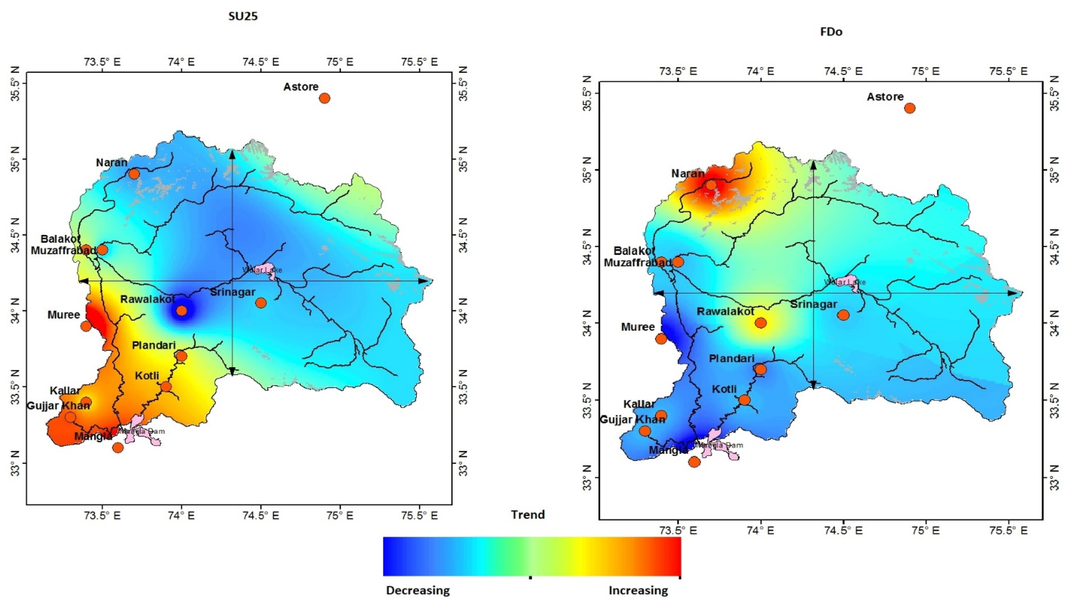
The annual regional trends of frost days (FDo) (when the temperature falls below 0 °C) show a decreasing trend in most parts of the basin during years 2000 to 2018, except some stations of the northwest region (such as Naran, Balakot, and Rawalakot), where a strong significant increasing trend ranges from 0.3 to 10 days/decade, as shown in Table 4. These findings are in line with recent studies [49]. Overall, the basin indicates a warming trend, as shown in Figure 3. The number of frost days has a very strong significant decreasing trend at the Murree and Mangla, which varies from 4 to 7 days per decade. Only five out of twelve stations show a significant increasing trend, and three are non-significant, as shown in Table 4. While seven stations demonstrate a decreasing trend, about 50% of them reveal a significant decreasing trend during the study period.
The annual count of summer days [14], when the temperature is greater than 25 °C, shows a spatially increasing trend in the southwest part of the region, as shown in Figure 3. The results are consistent with the findings of previous studies [37,50,51], whereas the northwest part of the region shows a cooling trend as compared to the Eastern Himalayas in Nepal. According to the results, there are only three stations (Muzaffarabad, Srinagar, and Astore) that reveal a strong significant decreasing trend, while most stations have shown non-significant decreasing trends for summer days except the southwest region of the study area, which is also confirmed by [52] that shows a decreasing trend in the frequency of summer days (SU25) over the southwest region.

4.3. Temperature Extreme Value Indices

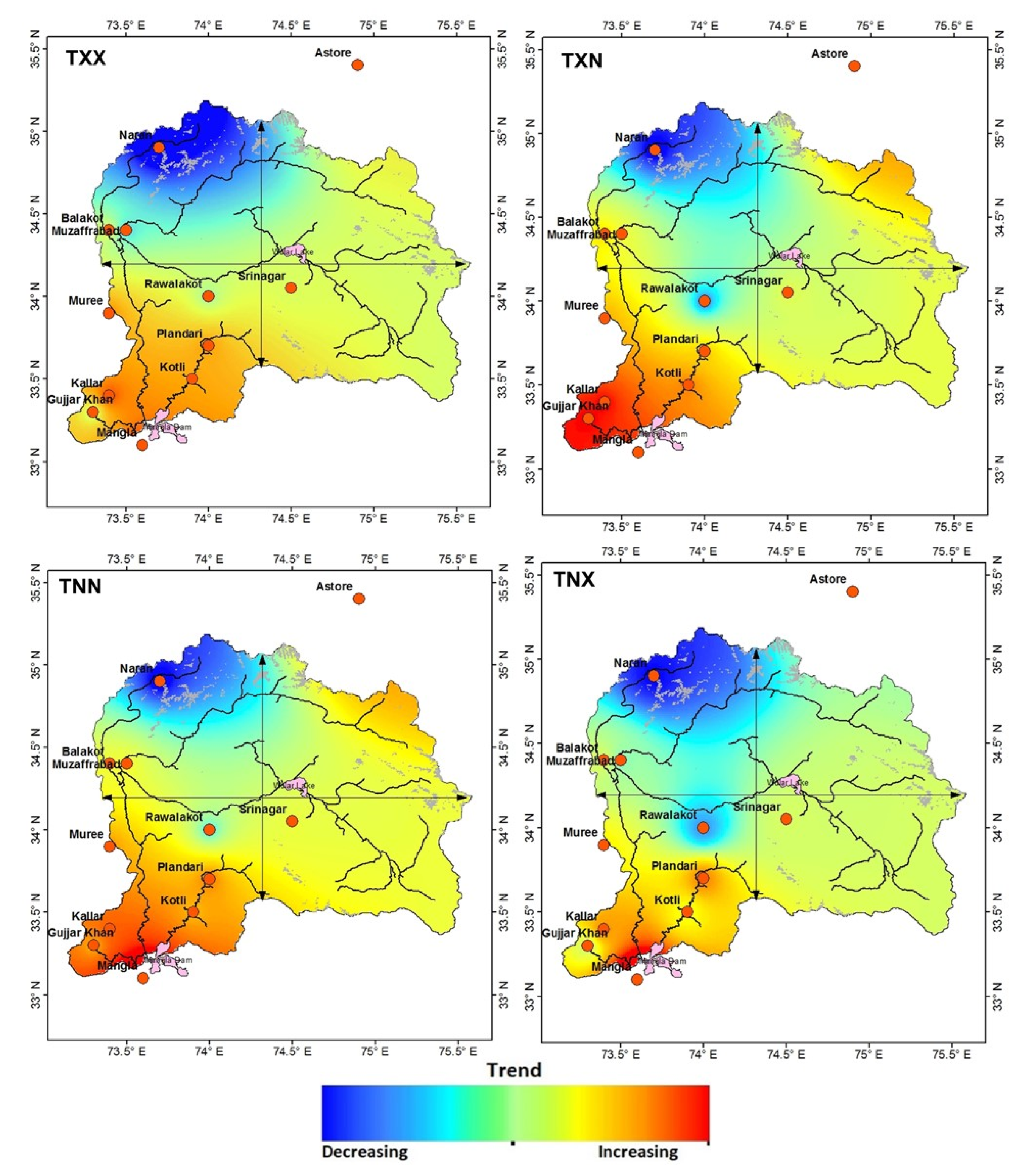
The annual maximum value of daily maximum temperature (TXX) indicates a strong significant decreasing trend in the northwest region from 0.22 to 0.4 °C/decade, as shown in Table 5. Yet the foothill area of the basin indicates non-significant increasing trends up to 0.1 °C/decade in the southwest region, as shown in Figure 4. These results agree with the [40]. The trends of the annual maximum value of daily maximum temperature (TXN) appear to be increasing significantly in the foothill region of the study area, which varies from 0.03 to 0.31 °C/decade. The spatial interpolation of TXN shows the increasing trends in the south to the east part of the basin, as shown in Figure 4. The behavior of increasing trend in the annual maximum and minimum value of maximum daily temperature is observed in the stations above the 2000 m elevation of the Tibetan Plateau [35].
The spatial distribution of annual minimum and maximum value of daily minimum (TNX, TNN) temperature is shown in Figure 4. According to this, the northwest part of the region shows a strong significant decreasing trend for both the maximum and minimum value of daily minimum temperature, varying from 0.1 to 0.8 °C/decade, as shown in Table 5, while most of the stations in the southern part indicate the warm trends on the foothill areas, which is also confirmed by [20].

4.4. Frequency of Temperature Relative Indices

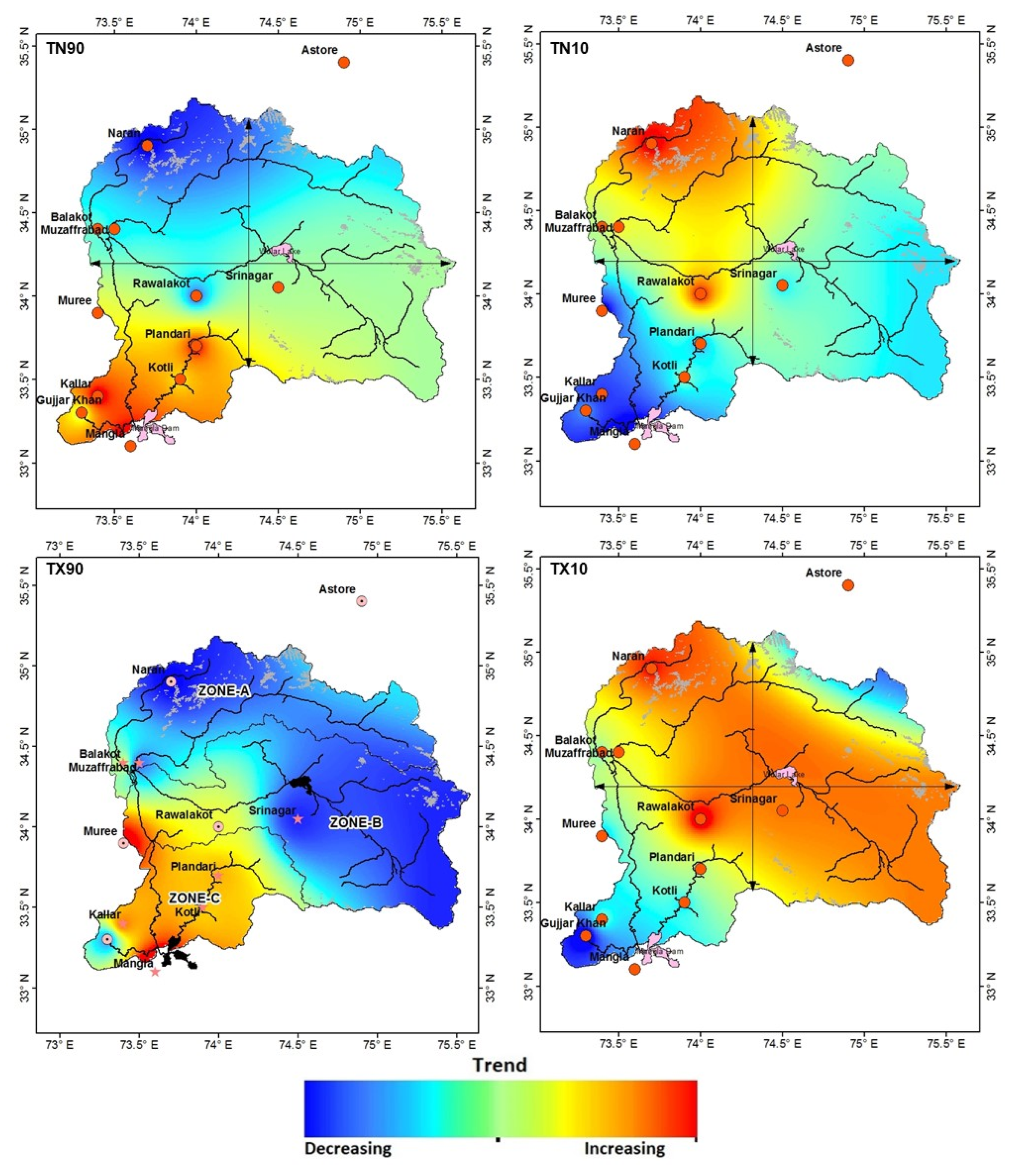
The frequency of warm/cold days and nights is spatially presented in Figure 5. The TX90 and TN90 measure the percentage values of daily maximum and minimum temperatures above the 90th percentile per decade. In the context of global warming, it is expected that the region shows the warming effect for days and nights, but, the stations on the elevation above the 1000 m of the basin show decreasing trends for warm days and nights, which is also confirmed by [20]. The regression slopes of trends for TX90 and TN90 vary from −0.1% to −1.05% and −0.08% to −1.6% days/decade, respectively, as shown in Table 6, along with their significance. The decreasing trends of warm days and nights may be due to the fluctuations in regional atmospheric circulations, topographic features, and thermodynamic feedback processes [12,35,50,53,54,55,56].
Simultaneously, the annual frequency trends of cold days and nights having the value of the daily maximum and minimum temperature below the 10th percentile indicate that the northwest and somehow northeast regions have increasing trends for cold days and nights, which also agrees with the findings of [31,52]. The rate of the increasing trend in the northwest and northeast for cold days and nights is 1 to 2 days/decade, as shown in Table 6. In comparison, the southern part of the study area indicates decreasing trends for cold days and nights for most of the stations, which also coincides with the findings of [20,52]. The spatial interpolation of cold days and nights is shown in Figure 5.

4.5. Warm and Cold Spells of Temperature

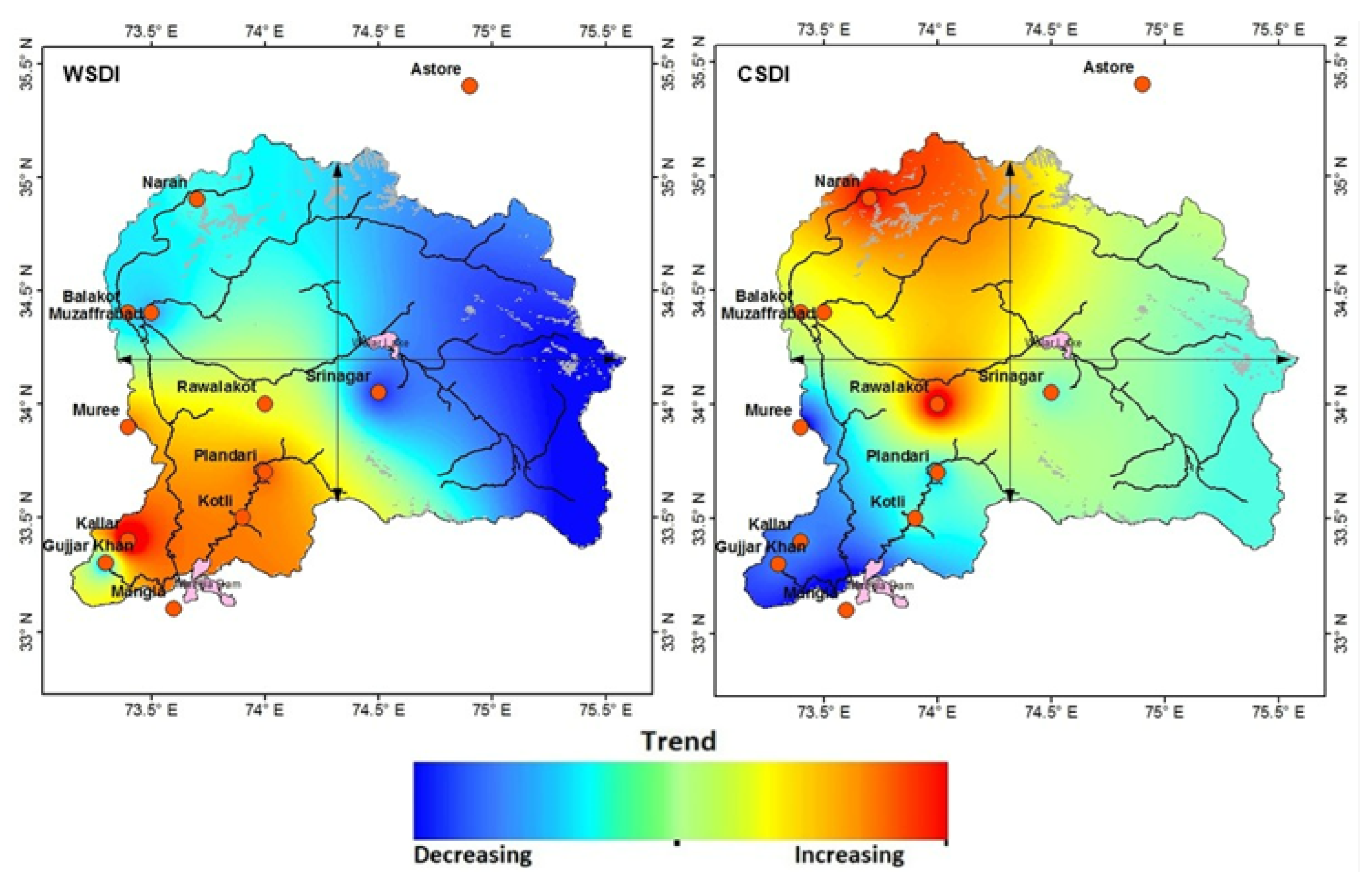
The number of warm spells in a year shows an increasing trend in the southern part of the region in the early 21st century, with a rate of two to five spells per decade, as shown in Table 7. The increasing behavior of warm spells in the southern region is also confirmed by [49]. Most glacier studies in the Eastern Himalayas (Nepal) report rapid deglaciation due to the warm trend [57,58]. The trend of warm spells in the northern region is decreasing, as shown in Figure 6, which is in contradiction with [20], and it might be due to the duration of the study period and station density which may affect the trends. Yet at the same time, [40] investigated that the snow-covered area of the study region has increased over the high-elevation zones of the Western Himalayas.
The frequency of cold spells shows the increasing trends in the northwest region of the study area because, in the northwest, there lie Karakoram mountains that host widespread glaciers [59]. Moreover, since the 1960s, the mean temperature of the Northwest Himalayas has declined, which is mainly the result of a cooling trend [60], whereas the frequency of the cold spells in the southern region shows a strong significant decreasing trend in the rate of 3 days per year.

5. Conclusions

This study analyzed the behavior of temperature extremes over the Northwest Himalayas region during the early 21st century based on ETCDI-recommended temperature extremes indices. This study indicates that the annual mean maximum and minimum temperature (Tmax, Tmin) have decreasing trends in the northwest region while significantly increasing trends in the southern region of the study area. The frequency of summer days [14] and warm spells (WSDI) also reveal increasing trends in the southwest region. In contrast, the frequency of cold spells and frost days shows decreasing trends in the northern region of the study area. The maximum and minimum value of daily maximum temperature (TXX, TXN) increases in the foothill area of the region while decreasing trends are noted in the high-elevation region. The days and nights are getting cool in the northwest region, while these are warmer in the low-elevation regions of the study area. Overall, the study concludes that the northwestern parts have cooling trends while the southwestern and southeastern parts have warming trends during the early 21st century. This study has some limitations regarding the density of temperatures recorded at stations of high elevations. In the future, the availability of more gauges can improve our findings.

Author Contributions

Conceptualization A.R., F.A. and X.W.; methodology A.R. and N.J.; software A.R. and F.A.; validation A.R., A.J. and N.J.; formal analysis A.R., N.J. and T.K.; investigation A.R. and T.K.; resources X.W.; data curation A.J., N.J. and T.K.; writing—original draft preparation A.R.; writing—review and editing X.W. and F.A.; visualization A.J. and T.K.; supervision X.W.; project administration X.W.; funding acquisition (APC) X.W. All authors have read and agreed to the published version of the manuscript.

Funding

This research received no external funding.

Institutional Review Board Statement

Not applicable.

Informed Consent Statement

Not applicable.

Data Availability Statement

Data is unavailable due to privacy restrictions.

Conflicts of Interest

The authors declare no conflict of interest.

References

  1. Easterling, D.R.; Horton, B.; Jones, P.D.; Peterson, T.C.; Karl, T.R.; Parker, D.E.; Salinger, M.J.; Razuvayev, V.; Plummer, N.; Jamason, P. Maximum and minimum temperature trends for the globe. Science 1997, 277, 364–367. [Google Scholar] [CrossRef] [Green Version]
  2. Guan, Y.; Zhang, X.; Zheng, F.; Wang, B. Trends and variability of daily temperature extremes during 1960–2012 in the Yangtze River Basin, China. Glob. Planet. Chang. 2015, 124, 79–94. [Google Scholar] [CrossRef] [Green Version]
  3. Labat, D.; Goddéris, Y.; Probst, J.L.; Guyot, J.L. Evidence for global runoff increase related to climate warming. Adv. Water Resour. 2004, 27, 631–642. [Google Scholar] [CrossRef]
  4. Zhai, P.; Zhang, X.; Wan, H.; Pan, X. Trends in total rainfall and frequency of daily rainfall extremes over China. J. Clim. 2005, 18, 1096–1108. [Google Scholar] [CrossRef]
  5. Stocker, T.F.; Qin, D.; Plattner, G.-K.; Alexander, L.V.; Allen, S.K.; Bindoff, N.L.; Bréon, F.-M.; Church, J.A.; Cubasch, U.; Emori, S. Technical summary. In Climate Change 2013: The Physical Science Basis. Contribution of Working Group I to the Fifth Assessment Report of the Intergovernmental Panel on Climate Change; Cambridge University Press: Cambridge, UK, 2013; pp. 33–115. [Google Scholar]
  6. Legg, S. IPCC, 2021: Climate Change 2021-the Physical Science basis. Interaction 2021, 49, 44–45. [Google Scholar]
  7. Noaa, N. State of the Climate: Global Climate Report for Annual 2018. 2019. Available online: www.ncdc.noaa.gov/sotc/global/201813 (accessed on 2 February 2021).
  8. Sillmann, J.; Kharin, V.V.; Zwiers, F.; Zhang, X.; Bronaugh, D. Climate extremes indices in the CMIP5 multimodel ensemble: Part 2. Future climate projections. J. Geophys. Res. Atmos. 2013, 118, 2473–2493. [Google Scholar] [CrossRef]
  9. Goswami, U.P.; Bhargav, K.; Hazra, B.; Goyal, M.K. Spatiotemporal and joint probability behavior of temperature extremes over the Himalayan region under changing climate. Theor. Appl. Climatol. 2018, 134, 477–498. [Google Scholar] [CrossRef]
  10. Bhutiyani, M.; Kale, V.S.; Pawar, N. Long-term trends in maximum, minimum and mean annual air temperatures across the Northwestern Himalaya during the twentieth century. Clim. Chang. 2007, 85, 159–177. [Google Scholar] [CrossRef]
  11. Bhutiyani, M.R.; Kale, V.S.; Pawar, N. Climate change and the precipitation variations in the northwestern Himalaya: 1866–2006. Int. J. Climatol. A J. R. Meteorol. Soc. 2010, 30, 535–548. [Google Scholar] [CrossRef]
  12. Dimri, A.; Ganju, A. Wintertime seasonal scale simulation over Western Himalaya using RegCM3. Pure Appl. Geophys. 2007, 164, 1733–1746. [Google Scholar] [CrossRef]
  13. Dong-Qi, Z.; Cun-De, X.; Wei-Gang, L. Analysis on Himalayan climate change in 1951-2010. Adv. Clim. Chang. Res. 2012, 8, 110. [Google Scholar]
  14. Gautam, R.; Hsu, N.; Lau, K.M.; Tsay, S.C.; Kafatos, M. Enhanced pre-monsoon warming over the Himalayan-Gangetic region from 1979 to 2007. Geophys. Res. Lett. 2009, 36, L07704. [Google Scholar] [CrossRef] [Green Version]
  15. Lau, W.K.; Kim, M.-K.; Kim, K.-M.; Lee, W.-S. Enhanced surface warming and accelerated snow melt in the Himalayas and Tibetan Plateau induced by absorbing aerosols. Environ. Res. Lett. 2010, 5, 025204. [Google Scholar] [CrossRef]
  16. Sharma, K.P.; Moore, B.; Vorosmarty, C.J. Anthropogenic, climatic, and hydrologic trends in the Kosi Basin, Himalaya. Clim. Chang. 2000, 47, 141–165. [Google Scholar] [CrossRef]
  17. Yadav, R.R.; Park, W.K.; Singh, J.; Dubey, B. Do the western Himalayas defy global warming? Geophys. Res. Lett. 2004, 31, L17201. [Google Scholar] [CrossRef]
  18. Pepin, N.C.; Arnone, E.; Gobiet, A.; Haslinger, K.; Kotlarski, S.; Notarnicola, C.; Palazzi, E.; Seibert, P.; Serafin, S.; Schöner, W.; et al. Climate changes and their elevational patterns in the mountains of the world. Rev. Geophys. 2022, 60, e2020RG000730. [Google Scholar] [CrossRef]
  19. Dar, T.; Rai, N.; Kumar, S.; Bhat, M.A. Climate change impact on cryosphere and streamflow in the Upper Jhelum River Basin. Environ. Monit. Assess. 2022, 194, 140. [Google Scholar] [CrossRef]
  20. Shekhar, M.; Chand, H.; Kumar, S.; Srinivasan, K.; Ganju, A. Climate-change studies in the western Himalaya. Ann. Glaciol. 2010, 51, 105–112. [Google Scholar] [CrossRef] [Green Version]
  21. Dimri, A.; Dash, S. Wintertime climatic trends in the western Himalayas. Clim. Chang. 2012, 111, 775–800. [Google Scholar] [CrossRef]
  22. Revadekar, J.; Hameed, S.; Collins, D.; Manton, M.; Sheikh, M.; Borgaonkar, H.; Kothawale, D.; Adnan, M.; Ahmed, A.; Ashraf, J. Impact of altitude and latitude on changes in temperature extremes over South Asia during 1971–2000. Int. J. Climatol. 2013, 33, 199–209. [Google Scholar] [CrossRef]
  23. Chen, B.; Chao, W.C.; Liu, X. Enhanced climatic warming in the Tibetan Plateau due to doubling CO2: A model study. Clim. Dyn. 2003, 20, 401–413. [Google Scholar] [CrossRef]
  24. Liu, X.; Cheng, Z.; Yan, L.; Yin, Z.-Y. Elevation dependency of recent and future minimum surface air temperature trends in the Tibetan Plateau and its surroundings. Glob. Planet. Chang. 2009, 68, 164. [Google Scholar] [CrossRef]
  25. Pepin, N.; Bradley, R.; Diaz, H.; Baraer, M.; Caceres, E.; Forsythe, N.; Fowler, H.; Greenwood, G.; Hashmi, M.; Liu, X. Elevation-dependent warming in mountain regions of the world. Nat. Clim. Chang. 2015, 5, 424–430. [Google Scholar]
  26. Shrestha, A. Climate change in the Hindu Kush-Himalayas and its impacts on water and hazards. APMN Bull. 2009, 9, 1–5. [Google Scholar]
  27. Yan, L.; Liu, X. Has climatic warming over the Tibetan Plateau paused or continued in recent years. Earth Ocean Atmos. Sci. 2014, 1, 13–28. [Google Scholar]
  28. Yan, L.; Liu, Z.; Chen, G.; Kutzbach, J.; Liu, X. Mechanisms of elevation-dependent warming over the Tibetan plateau in quadrupled CO2 experiments. Clim. Chang. 2016, 135, 509–519. [Google Scholar] [CrossRef]
  29. Panday, P.K.; Thibeault, J.; Frey, K.E. Changing temperature and precipitation extremes in the Hindu Kush-Himalayan region: An analysis of CMIP3 and CMIP5 simulations and projections. Int. J. Climatol. 2015, 35, 3058–3077. [Google Scholar] [CrossRef]
  30. Alexander, L.V.; Zhang, X.; Peterson, T.C.; Caesar, J.; Gleason, B.; Klein Tank, A.; Haylock, M.; Collins, D.; Trewin, B.; Rahimzadeh, F. Global observed changes in daily climate extremes of temperature and precipitation. J. Geophys. Res. Atmos. 2006, 111, 1042–1063. [Google Scholar] [CrossRef] [Green Version]
  31. Donat, M.; Alexander, L.V.; Yang, H.; Durre, I.; Vose, R.; Dunn, R.J.; Willett, K.M.; Aguilar, E.; Brunet, M.; Caesar, J. Updated analyses of temperature and precipitation extreme indices since the beginning of the twentieth century: The HadEX2 dataset. J. Geophys. Res. Atmos. 2013, 118, 2098–2118. [Google Scholar] [CrossRef] [Green Version]
  32. Frich, P.; Alexander, L.V.; Della-Marta, P.; Gleason, B.; Haylock, M.; Tank, A.K.; Peterson, T. Observed coherent changes in climatic extremes during the second half of the twentieth century. Clim. Res. 2002, 19, 193–212. [Google Scholar] [CrossRef] [Green Version]
  33. Klein Tank, A.M.G.; Peterson, T.C.; Quadir, D.A.; Dorji, S.; Zou, X.; Tang, H.; Santhosh, K.; Joshi, U.R.; Jaswal, A.K.; Kolli, R.K.; et al. Changes in daily temperature and precipitation extremes in central and south Asia. J. Geophys. Res. Atmos. 2006, 111, D16105. [Google Scholar] [CrossRef] [Green Version]
  34. Manton, M.J.; Della-Marta, P.M.; Haylock, M.R.; Hennessy, K.; Nicholls, N.; Chambers, L.; Collins, D.; Daw, G.; Finet, A.; Gunawan, D. Trends in extreme daily rainfall and temperature in Southeast Asia and the South Pacific: 1961–1998. Int. J. Climatol. 2001, 21, 269–284. [Google Scholar] [CrossRef]
  35. Wang, B.; Zhang, M.; Wei, J.; Wang, S.; Li, S.; Ma, Q.; Li, X.; Pan, S. Changes in extreme events of temperature and precipitation over Xinjiang, northwest China, during 1960–2009. Quat. Int. 2013, 298, 141–151. [Google Scholar] [CrossRef]
  36. Almazroui, M.; Saeed, F.; Saeed, S.; Ismail, M.; Ehsan, M.A.; Islam, M.N.; Abid, M.A.; O’Brien, E.; Kamil, S.; Rashid, I.U. Projected changes in climate extremes using CMIP6 simulations over SREX regions. Earth Syst. Environ. 2021, 5, 481–497. [Google Scholar] [CrossRef]
  37. You, Q.; Kang, S.; Aguilar, E.; Yan, Y. Changes in daily climate extremes in the eastern and central Tibetan Plateau during 1961–2005. J. Geophys. Res. Atmos. 2008, 113, D07101. [Google Scholar] [CrossRef] [Green Version]
  38. Zhou, Y.; Ren, G. Change in extreme temperature event frequency over mainland China, 1961− 2008. Clim. Res. 2011, 50, 125–139. [Google Scholar] [CrossRef] [Green Version]
  39. Zahid, M.; Rasul, G. Frequency of extreme temperature and precipitation events in Pakistan 1965–2009. Sci. Int. 2011, 23, 313–319. [Google Scholar]
  40. Baidya, S.K.; Shrestha, M.L.; Sheikh, M.M. Trends in daily climatic extremes of temperature and precipitation in Nepal. J. Hydrol. Meteorol. 2008, 5, 38–51. [Google Scholar]
  41. Shrestha, A.B.; Bajracharya, S.R.; Sharma, A.R.; Duo, C.; Kulkarni, A. Observed trends and changes in daily temperature and precipitation extremes over the Koshi river basin 1975–2010. Int. J. Climatol. 2017, 37, 1066–1083. [Google Scholar] [CrossRef] [Green Version]
  42. Azmat, M.; Choi, M.; Kim, T.-W.; Liaqat, U.W. Hydrological modeling to simulate streamflow under changing climate in a scarcely gauged cryosphere catchment. Environ. Earth Sci. 2016, 75, 186. [Google Scholar] [CrossRef]
  43. Yaseen, M.; Rientjes, T.; Nabi, G.; Latif, M. Assessment of recent temperature trends in Mangla watershed. J. Himal. Earth Sci. 2014, 47, 107–121. [Google Scholar]
  44. Mahmood, R.; Jia, S. Spatial and temporal hydro-climatic trends in the transboundary Jhelum River basin. J. Water Clim. Chang. 2017, 8, 423–440. [Google Scholar] [CrossRef] [Green Version]
  45. Zhang, X.; Alexander, L.; Hegerl, G.C.; Jones, P.; Tank, A.K.; Peterson, T.C.; Trewin, B.; Zwiers, F.W. Indices for monitoring changes in extremes based on daily temperature and precipitation data. Wiley Interdiscip. Rev. Clim. Chang. 2011, 2, 851–870. [Google Scholar] [CrossRef]
  46. Aguilar, E.; Peterson, T.C.; Obando, P.R.; Frutos, R.; Retana, J.A.; Solera, M.; Soley, J.; García, I.G.; Araujo, R.M.; Santos, A.R.; et al. Changes in precipitation and temperature extremes in Central America and northern South America, 1961–2003. J. Geophys. Res. Atmos. 2005, 110, D23107. [Google Scholar] [CrossRef]
  47. Peterson, T.C.; Taylor, M.A.; Demeritte, R.; Duncombe, D.L.; Burton, S.; Thompson, F.; Porter, A.; Mercedes, M.; Villegas, E.; Semexant Fils, R. Recent changes in climate extremes in the Caribbean region. J. Geophys. Res. Atmos. 2002, 107, 4601. [Google Scholar] [CrossRef] [Green Version]
  48. Dereje, A.; Kindie, T.; Girma, M.; Birru, Y.; Wondimu, B. Variability of rainfall and its current trend in Amhara region, Ethiopia. Afr. J. Agric. Res. 2012, 7, 1475–1486. [Google Scholar] [CrossRef]
  49. Duhan, D.; Pandey, A. Statistical analysis of long term spatial and temporal trends of precipitation during 1901–2002 at Madhya Pradesh, India. Atmos. Res. 2013, 122, 136–149. [Google Scholar] [CrossRef]
  50. Shafiq, M.U.; Rasool, R.; Ahmed, P.; Dimri, A. Temperature and precipitation trends in Kashmir Valley, north western Himalayas. Theor. Appl. Climatol. 2019, 135, 293–304. [Google Scholar] [CrossRef]
  51. Sheikh, M.; Manzoor, N.; Ashraf, J.; Adnan, M.; Collins, D.; Hameed, S.; Manton, M.; Ahmed, A.; Baidya, S.; Borgaonkar, H. Trends in extreme daily rainfall and temperature indices over South Asia. Int. J. Climatol. 2015, 35, 1625–1637. [Google Scholar] [CrossRef]
  52. Sun, W.; Mu, X.; Song, X.; Wu, D.; Cheng, A.; Qiu, B. Changes in extreme temperature and precipitation events in the Loess Plateau (China) during 1960–2013 under global warming. Atmos. Res. 2016, 168, 33–48. [Google Scholar] [CrossRef]
  53. You, Q.-L.; Ren, G.-Y.; Zhang, Y.-Q.; Ren, Y.-Y.; Sun, X.-B.; Zhan, Y.-J.; Shrestha, A.B.; Krishnan, R. An overview of studies of observed climate change in the Hindu Kush Himalayan (HKH) region. Adv. Clim. Chang. Res. 2017, 8, 141–147. [Google Scholar] [CrossRef]
  54. Khan, N.; Shahid, S.; Ismail, T.b.; Wang, X.-J. Spatial distribution of unidirectional trends in temperature and temperature extremes in Pakistan. Theor. Appl. Climatol. 2019, 136, 899–913. [Google Scholar] [CrossRef]
  55. Maenza, R.A.; Agosta, E.A.; Bettolli, M.L. Climate change and precipitation variability over the western ‘Pampas’ in Argentina. Int. J. Climatol. 2017, 37, 445–463. [Google Scholar] [CrossRef]
  56. Priya, P.; Krishnan, R.; Mujumdar, M.; Houze, R.A. Changing monsoon and midlatitude circulation interactions over the Western Himalayas and possible links to occurrences of extreme precipitation. Clim. Dyn. 2017, 49, 2351–2364. [Google Scholar] [CrossRef]
  57. Wang, P.X.; Wang, B.; Cheng, H.; Fasullo, J.; Guo, Z.; Kiefer, T.; Liu, Z. The global monsoon across time scales: Mechanisms and outstanding issues. Earth-Sci. Rev. 2017, 174, 84–121. [Google Scholar] [CrossRef]
  58. Wang, S.Y.; Davies, R.E.; Huang, W.R.; Gillies, R.R. Pakistan’s two-stage monsoon and links with the recent climate change. J. Geophys. Res. Atmos. 2011, 116, D16114. [Google Scholar] [CrossRef] [Green Version]
  59. Fujita, K.; Nakawo, M.; Fujii, Y.; Paudyal, P. Changes in glaciers in hidden valley, Mukut Himal, Nepal Himalayas, from 1974 to 1994. J. Glaciol. 1997, 43, 583–588. [Google Scholar] [CrossRef] [Green Version]
  60. Kadota, T.; Ageta, Y. On the relation between climate and retreat of Glacier AX010 in the Nepal Himalaya from 1978 to 1989. Bull. Glacier Res. 1992, 10, 1–10. [Google Scholar]
Figure 1. Study Area in Northwest Himalayas.
Atmosphere 14 00454 g001
Figure 2. Trends of Annual Maximum and Minimum Temperature Over the Northwest Himalayas (water lakes represented in pink color).
Atmosphere 14 00454 g002
Figure 3. Absolute temperature indices summer days (SU25) and frost days (FDo).
Atmosphere 14 00454 g003
Figure 4. Spatial Trends of monthly maximum value of maximum temperature(TNX), monthly minimum value of maximum temperature(TXN), monthly maximum value of minimum temperature(TXX), monthly maximum value of minimum temperature(TNN).
Atmosphere 14 00454 g004
Figure 5. Spatial Trends of Percentage of warm nights (TN90), Percentage of cold nights (TN10), Percentage of warm days (TX90), Percentage of cold days (TX10).
Atmosphere 14 00454 g005
Figure 6. Spatial trends of warm spell duration (WSDI) and Cold spell duration CSDI.
Atmosphere 14 00454 g006
Table 1. Climate stations of Pakistan Meteorological and Indian Meteorological Department in the study area.
Sr. No.StationsLatitude [43]Longitude [43]Elevation (m.a.s.l)
1ASTORE35.474.92168
2NARAN34.973.72363
3BALAKOT34.473.4995.5
4MUZAFFARABAD34.473.5702
5MURREE33.973.42206
6RAWALAKOT34.074.01677
7PALANDRI33.773.71402
8KOTLI33.573.9610
9KALLAR33.473.4518
10GUJJAR KHAN33.373.3457
11MANGLA33.173.6282
12SRINAGAR34.174.51587
Table 2. Groups of temperature indices.
Indices Group DescriptionUnit
Annual Max/Min
Temperature
TMAXAnnual maximum temperatureAnnual maximum value of temperature°C
TMINAnnual minimum temperatureAnnual minimum value of temperature°C
Absolute Indices Day
FDFrost daysYear Tn (Lowest temperature of the day) < 0 °CDay
SU25Summer daysYear TX (highest temperature of the day) > 25 °C
Extreme Value Indices
TXxMaximum TXMonthly maximum value of TX°C
TNxMaximum TNMonthly minimum value of TX°C
TXnMinimum TXMonthly maximum value of TN°C
TNnMinimum TNMonthly minimum value of TN°C
Relative Indices
TN10pCool nightsPercentage of days when TN < 10thDay
TX10pCool daysPercentage of days when TX < 10th percentileDay
TN90pWarm nightsPercentage of days when TN > 90th percentileDay
TX90pWarm daysPercentage of days when TX > 90th percentileDay
Extreme Spell’s Indices
CSDICold spell duration indexAnnual count of days with at least 6 consecutive days when TN < 10th percentileDay
WSDIWarm spell duration indexAnnual count of days with at least 6 consecutive days when TX > 90th percentileDay
Table 3. Annual max. and min. temperature slopes and trends.
StationsTmaxTmin
Slope (C/Decade)TrendSlope (C/Decade)Trend
Astore−0.03NSF−0.04NSF
Balakot−0.02NSF−0.01NSF
Gujjar Khan0.00NSF0.02NSF
Kallar−0.02NSF0.31SSF
Kotli0.00NSF0.03NSF
Mangla0.09SSF0.91VSSF
Murree0.07NSF0.21VSSF
Muzaffrabad−0.17VSSF−0.07SSF
Naran−0.54VSSF−0.74SSF
Plandari−0.02NSF0.22SSF
Rawalakot−0.46SSF−0.53SSF
Srinagar−0.14VSSF0.02NSF
Table 4. Trends of absolute temperature indices slopes and trends.
StationsSU25FDo
Slope (Days/Decade)TrendSlope (Days/Decade)Trend
Astore−1.44VSSF0.17NSF
Balakot−1.01WSF0.30NSF
Gujjar Khan−0.12NSF−0.15NSF
Kallar−1.41NSF−0.20NSF
Kotli−0.70NSF−0.07NSF
Mangla0.75NSF−7.18VSSF
Murree1.93NSF−4.02VSSF
Muzaffrabad−2.67SSF−0.09NSF
Naran−2.48NSF10.11SSF
Plandari−0.87NSF−1.13SSF
Rawalakot−4.44WSF5.62VSSF
Srinagar−2.19VSSF0.15NSF
Table 5. Absolute temperature indices slopes and trends.
StationsTXX
Warmest Day
TXN
Coldest Day
TNX
Warmest Night
TNN
Coldest Night
Slope (C/Year)TrendSlope (C/Year)TrendSlope (C/Year)TrendSlope (C/Year)Trend
Astore−0.06NSF0.09NSF−0.12SSF0.19WSF
Balakot−0.05NSF0.04NSF0.02NSF0.00NSF
Gujjar Khan−0.15NSF0.29SSF−0.01NSF0.10NSF
Kallar0.09NSF0.31VSSF0.32VSSF0.32VSSF
Kotli0.00NSF0.16NSF0.11NSF0.12NSF
Mangla0.10NSF0.26SSF1.03VSSF0.90VSSF
Murree0.04NSF0.08NSF0.13NSF0.22VSSF
Muzaffrabad−0.22SSF−0.10NSF−0.16SSF0.02NSF
Naran−0.41SSF−0.81SSF−0.70VSSF−0.83VSSF
Plandari0.02NSF0.05NSF0.35SSF0.30SF
Rawalakot−0.15NSF−0.66VSSF−0.45VSSF−0.40SSF
Srinagar−0.09SSF−0.11NSF0.00NSF−0.02NSF
Table 6. Relative temperature indices slopes and trends.
StationsTX90
(Warm Day)
TN90
(Warm Night)
TX10
(Cold Day)
TN10
(Cold Night)
Slope (Days/Year)TrendSlope (Days/Year)TrendSlope (Days/Year)TrendSlope (Days/Year)Trend
Astore−0.49WSF−0.60VSSF−0.32SSF−0.03NSF
Balakot−0.10NSF−0.08NSF0.07NSF−0.05NSF
Gujjar Khan−0.69SSF−0.10NSF−0.90NSF−0.52SSF
Kallar0.46NSF2.40VSSF0.39NSF−1.04SSF
Kotli0.25NSF0.65NSF−0.02NSF0.02NSF
Mangla1.29VSSF2.74VSSF−0.15NSF−2.19VSSF
Murree0.83NSF0.60SSF−0.10NSF−1.57VSSF
Muzaffrabad−0.81VSSF−0.57VSSF0.64SSF0.53VSSF
Naran−1.05NSF−1.61VSSF1.09SSF1.38SSF
Plandari0.31NSF2.25SSF0.27NSF−0.71VSSF
Rawalakot0.04NSF−1.45SSF1.48SSF1.67SSF
Srinagar−0.99VSSF0.08NSF0.85VSSF−0.40SSF
Table 7. Slopes and trends of cold and warm spells.
StationsWSDICDSI
Slope (Days/Year)TrendSlope (Days/Year)Trend
Astore−0.20NSF0.12NSF
Balakot0.17NSF0.03NSF
Gujjar Khan−1.03VSSF−0.97NSF
Kallar5.09NSF−0.78NSF
Kotli2.56NSF−0.14NSF
Mangla2.90VSSF−3.19VSSF
Murree2.80NSF−2.09VSSF
Muzaffrabad−0.47WSF0.65SSF
Naran0.50NSF1.55NSF
Plandari3.03NSF−0.84NSF
Rawalakot1.46NSF2.52SSF
Srinagar−1.11VSSF−0.40NSF
Disclaimer/Publisher’s Note: The statements, opinions and data contained in all publications are solely those of the individual author(s) and contributor(s) and not of MDPI and/or the editor(s). MDPI and/or the editor(s) disclaim responsibility for any injury to people or property resulting from any ideas, methods, instructions or products referred to in the content.