Article

Assessment of Air Pollution in Different Areas (Urban, Suburban, and Rural) in Slovenia from 2017 to 2021

1
Faculty of Chemistry and Chemical Engineering, University of Maribor, Smetanova 17, 2000 Maribor, Slovenia
2
Milan Vidmar Electric Power Research Institute, Department for Environment, Hajdrihova 2, 1000 Ljubljana, Slovenia
*
Author to whom correspondence should be addressed.
Atmosphere 2023, 14(3), 578; https://doi.org/10.3390/atmos14030578
Submission received: 23 February 2023 / Revised: 10 March 2023 / Accepted: 14 March 2023 / Published: 17 March 2023

Abstract

:
Air pollution can have a significant effect on human health. The present work is focused on the investigation of daily, monthly, and annual concentration levels of five typical air pollutants (SO2, NO2, NOX, PM10, and PM2.5) in the Republic of Slovenia (RS) from January 2017 to December 2021. The study was conducted at five different monitoring stations of the following kind: traffic (A), industrial (D), and background (B, C, E). The obtained results showed a decline in the average concentrations for all the studied air pollutants through the years, respectively. The daily average SO2 concentrations were the lowest in the year 2021 at location B, which is classified as background location, while the highest were detected in the year 2018 at location E, which is also classified as background location. The average daily concentrations of NO2 and NOX were the highest at location A in the year 2017, whereas the lowest were detected in the year 2010 and 2021. It is believed that those results are a consequence of measures set by the Slovenian government during the COVID-19 pandemic. The PM10 and PM2.5 daily average concentrations were the highest at location A in 2017, while the lowest were observed in the year 2019 at location C. Meteorological parameters (temperature, wind speed, and relative humidity) were studied in addition. In general, the high temperatures in ambient air are responsible for the intense concentrations of air pollutants. It was found in the study results for temperature, wind speed, and relative humidity that no significant difference was shown between studied years.

1. Introduction

Air pollution is considered as one of the most important public health problems related to environmental pollution. It represents a major global threat that is practically impossible to avoid, especially in developing countries. According to the European Environmental Agency (EEA) and the World Health Organization (WHO, Geneva, Switzerland), in the last decade, air pollution has become the second largest environmental issue, just after climate change [1]. Every year, approximately 7 million people die because of it, from which roughly 4.9 million deaths are caused by urban ambient air [1].
Lately, there have been critically high concentrations of air pollutants measured in many large European (EU) cities, affecting the quality of life and public health [2]. Among all air pollutants, sulfur dioxide (SO2), nitrogen oxides (NO2/NOX), ozone (O3), carbon oxides (CO, CO2), particulate matter (PM), and volatile organic compounds (VOCs) are considered as some of the most common anthropogenic air pollutants caused by heavy road traffic, domestic heating, and local industry [3,4]. Years ago, SO2 was declared as the largest environmental problem in the EU caused by the production and co-production of electricity and thermal energy, industrial processes, and the usage of coal for domestic heating in households, but, today, NO2/NOX, CO2, and, especially, particulate matter (PM) are taking the lead [5]. It has been stated by the EEA that, between the years 2005 and 2019, emissions of the abovementioned pollutants declined significantly in most EU countries. For example, SOX emissions decreased by 76%, NOX by 42%, VOCs by 29%, and PM2.5 by 29% [6]. The cause for such a decline in emissions is partly due to a decrease in emissions from the energy, industry and transport sectors, and partly due to the laws and standards adopted, legalized, and updated through the years in the EU regarding air pollution, such as the “Large Combustion Plant Directive (EC/80/2001)”, the “Industrial Emissions Directive (EC/75/2010)”, “European Pollutant Release and Transfer Register Regulation (EC/166/2006)”, “Directive on Ambient Air Quality and Cleaner Air for Europe (EC/50/2008)”, and the “Directive on heavy metals and polycyclic aromatic hydrocarbons in ambient air EC/107/2004)”.
In addition, not long ago, almost all countries revised their air quality guidelines world-wide, and proposed new regulations according to the guidelines published by the WHO in 2021 [7]. The guidelines were revised as a result of the growing threat of air pollution on population health [8,9,10,11], and contain information regarding limit values of air pollutants, which are generally lower compared to those in the 2005 version [12]. The following differences could be observed: for SO2, the daily limit value increased from 20 µg/m3 in 2005 to 40 µg/m3 in the 2021 guidelines, while the daily limit value for the NO2 parameter in the 2005 guidelines was not determined, whereas the new regulations proposed a daily limit value of 25 µg/m3. An annual limit value for the NO2 parameter decreased from 40 µg/m3 set in the 2005 guidelines to 10 µg/m3 in the 2021 guidelines. For PM10, the daily limit value of 50 µg/m3 decreased to 45 µg/m3, and, in the same way, the annual limit value decreased from 20 µg/m3 to 15 µg/m3. A similar value was obtained for the PM2.5 parameter. The daily limit value of 25 µg/m3 set in 2005 decreased to 15 µg/m3 in 2021, and, consequently, the annual limit value decreased from 10 µg/m3 to 5 µg/m3.
Systematic measurements of the concentrations of air pollutants at permanent measuring points in the Republic of Slovenia (RS) began in the mid-1970s by the Slovenian Environment Agency (ARSO) and have since provided basic air quality data [13]. The measuring network in the RS currently consists of 27 ground-based nationwide monitoring stations, with 23 more monitoring stations owned by industrial companies or municipalities. These monitoring stations are based in eight different regions, thirteen different municipalities, and are divided by area (urban, suburban, and rural) and measurement (traffic, background, and industrial location) type [14]. It has been stated by ARSO and the National Institute for Public Health (NIJZ), that recently, the RS has currently been experiencing excessive air pollution [15].
Air pollution in the country is generally caused by traffic and individual fireplaces, as well as by industry (coal burning for energy generation, industrial emissions, waste burning, construction activities) [15]. It is the terrain that makes air pollution in the country more susceptible to weather variability, especially during winter time when there are temperature inversions [3]. ARSO additionally proposed national regulations regarding air quality, which mostly coincide with those proposed by the WHO. For SO2, the daily limit value is set to 125 µg/m3 and must not be exceeded for more than three times per year. For NO2, the daily limit value is not determined, whereas the annual limit value is set to 40 µg/m3. For PM10, the daily limit value is 50 µg/m3 and must not be exceeded 35 times per year, while an annual limit value is set to 40 µg/m3. Lastly, the daily limit value for PM2.5 parameter is 25 µg/m3 (must not be exceeded 24 times per year) and the annual limit value decreased to 20 µg/m3 [5]. The regulations are currently valid.
In such a context, the main goal of this work is to determine, analyze, and compare the concentrations of some basic air pollutants (SO2, NO2/NOX, PM10, and PM2.5) in the ambient air at five sampling locations, characterized as traffic, industrial, and background, based in the Republic of Slovenia (RS), between the years 2017 and 2021 to determine the differences between them. These years were chosen because they represent milestones in analyzing air quality in the RS, as the years 2020 and 2021 were marked with the COVID-19 pandemic. Previous years, 2017–2019, were included in the study to obtain comparative results. The chosen sampling locations present a region diversity in the RS. Related meteorological parameters (temperature, relative humidity, wind speed, and wind direction) were studied as well.

2. Methodology

2.1. Study Area

The RS is located in Central Europe, at 46.15° N and 46.08° E, with an average of 492 m above mean sea level. It is located in the southeastern part of the Alps, surrounded by the mountains, forests, and Adriatic sea. The climate is influenced by a variety of geographical relief—there are fewer lowlands, valleys, and basins, which are surrounded by hills. There are three typical climates in the country: a continental climate with a stark difference in winter and summer temperatures in the northeast; a sub-Mediterranean climate in the coastal region; and a severe Alpine climate present in the high mountain regions. Precipitation, often coming from the Gulf of Genoa, varies across the country as well, with over 3.500 mm in some western regions and dropping down to 800 mm in Prekmurje [14]. The winds (north, northeast, and southeast winds) are mainly weak, especially on the ground, due to the characteristic leeward position.
National and local meteorology and relief variability of the surface are closely related to the concentration of emissions in the air, so for a comprehensive insight into the state of ambient air quality in the environment, it is necessary to monitor meteorological parameters as well [16]. For instance, due to the typical temperature inversions in the cold parts of the calendar year, emissions of harmful substances can remain longer in the air and can therefore cause a lot of air pollution within a relatively small volume of air [17]. This situation is most problematic in populated valleys and basins, where the population density is the highest and discharges are most common. In addition, national and local meteorology depends on the relief diversity in the environment, as it mainly affects the movement of air masses. In the case of favorable meteorological conditions, emissions can travel long distances and thus affect a larger area [16].
Therefore, the study of SO2, NO2/NOX, PM10, and PM2.5 pollution characteristics in the RS is of great significance for atmospheric pollution management in the EU.

2.2. Location Description

This study was conducted in five different monitoring stations (Figure 1). The first monitoring station, hereinafter defined as sampling location A, is located in the heart of the RS, in the capital city Ljubljana. The station represents a favorable sampling site due to its central position in the city center (1000 m distant) surrounded by buildings of different sizes. The monitoring station is located very close to a road with significant daily traffic (10 m distant). In addition, the capital city is the geographical, cultural, economical, political, and administrative center of the country, an important transport hub, with a junction of international motorways running in four directions (crossing two corridors-directions) and railway lines (five to six directions). The second monitoring station, hereinafter defined as sampling location B, is located in the north-east of the RS, at the confluence of the Savinja and Voglajna rivers in the Lower Savinja Valley, approximately 3000 m distant from the city center. This monitoring station is surrounded by industrial facilities, such as a thermal power plant (around 4000 m distant) or metallurgical-chemical facility (around 4000 m). The third monitoring station, hereinafter defined as sampling location C, is located in the northern part of the RS, approximately 13,000 m distant from the capital city. The monitoring station is located close to the primary school, local hospital, and sports facilities (around 500 m distant). The fourth monitoring station, hereinafter defined as sampling location D, is located in the north-east of the RS in the valley along the Paka river, with a thermal power plant distant only by 500 m. Lastly, the fifth monitoring station, hereinafter defined as sampling location E, is located in the south-east of the RS, around 6000 m away from the nuclear power plant. The monitoring station is located in the typical rural area of the country.
All monitoring stations are located approximately 1 m above the ground, and are equipped with air condition and ventilation. Table 1 shows the characteristics of studied sampling locations. The classification and description of area (urban, suburban, and rural) and measurement (traffic, industrial, background) type is summarized as in the official national document stated by Bec et al. [17]. The RS has a typical spatial dispersion of settlement. Compared to other European cities, Slovenian cities are small- to medium-sized. Out of a total of 6.035 Slovenian settlements, 90% of settlements have less than 500 inhabitants and only two settlements have more than 50,000 inhabitants (Ljubljana and Maribor). There are three types of regions in the RS: urban, suburban, and rural. Urban area type indicates the area of a city or urban settlement with nearby urbanized surroundings, which differs from the more distant hinterland, mainly in terms of higher population density, compact construction, and a small share of the farming population. Suburban area type indicates an area type that is increasingly spreading to the countryside, with visible effects on the changed social-geographical, economic-geographical, and physical images of settlements. Meanwhile, rural area type indicates typical agricultural areas. The monitoring station with classification »traffic« is the one that measures air pollution near the ground level along the street, the »industrial« monitoring station is the one that measures close to the industrial areas, such as industrial pants, power plants, or thermal power plants, while the »background« monitoring station is the one that usually measures tens of meters in the air.

2.3. Data Sources and Collection

The air pollutants data and meteorological data were obtained from the Milan Vidmar Electric Power Research Institute (EIMV), the Department for the Environment, and the Slovenian Environment Agency (ARSO). Real time data from the monitoring stations are available on open access to the public on the following platform: https://www.arso.gov.si/zrak/kakovost%20zraka/podatki/ (accessed on 15 March 2023).
The concentrations of the five basic air pollutants, SO2, NO2/NOX, PM10, and PM2.5, were collected from January 2017 to December 2021 at the above-described measuring locations, respectively. SO2 was measured using a UV fluorescence-based instrument (Teledyne API, model 100E), NO2 and NOX were determined using a chemiluminiscence analyzer (Teledyne API, model 200E), and PM10 and PM2.5 were analyzed using an automatic gravimetric instrument (Sven Leckel, model SEQ47/50). Pre-weighed (WhatmanTM, diameter 47 mm, porosity 8.0 and 0.4 µm) and prebaked (850 °C, 3 h) fiber filters have been used. Before and after the sampling, the filters were placed in a room with controlled humidity 50 ± 5% and temperature 25 ± 2 °C, for at least 48 h before being weighed using a Mettler Toledo analytical balance, model AG 245, with a resolution of 0.01 mg. The mass concentration of particles in the air was expressed in µg/m3. The mass determination was performed under repeatability conditions (n > 3), aiming at minimizing the mass uncertainty. Outdoor air quality analyzers were installed in the measuring station, which was equipped with air conditioning and communication equipment.
In addition, real time meteorological data on the daily average temperature (T), relative humidity (RH), wind direction (WD), and wind speed (WS) during the study period at all measuring locations were obtained using the following monitoring equipment: the measurements of air temperature were performed with a resistance thermometer (ThermometerTM, model RS232), relative humidity measurements were performed with a capacitive encoder, which, with the help of an electronic circuit line, raised and amplified the changes in humidity in the air, and converted them into a suitable analogue electrical output signal (Vaisala Weather Transmitter, model WXT520), and finally, the measurements of wind direction and wind speed were performed with an ultrasonic anemometer (Vaisala Weather Transmitter WXT520).
During the study periods, in order to determine conformity, all measuring devices were scientifically managed and maintained to ensure adequate control over the measured values and conditions, and to avid any possible contamination [18].

2.4. Evaluation Method

The hourly values were averaged for each day to obtain average daily concentrations for each studied pollutant at each location. Average monthly and yearly concentrations were studied as well. For each pollutant, the average data are discussed based on location and studied year (2017 and 2021, respectively). The minimum and maximum values are added with standard deviations. It must be taken into account that not all air pollutants (SO2, NO2/NOX, PM10, or PM2.5) are measured at all studied locations during all study periods. For example, on location C, only parameter PM10 was measured through the years; therefore, obtained results are discussed only for this parameter at this location. Furthermore, the daily average concentrations of all basic air pollutants were calculated only when there were more than 16 h of valid data [19]. Furthermore, the associations between NO2 and NOX, and PM10 and PM2.5 were investigated using Pearson’s correlation coefficient. The results are presented separately for nitrogen oxides and particulate matter, based on the location and studied year. Finally, the meteorological parameters were investigated.
Quality control was carried out daily to ensure reliability of the monitoring data. All measuring devices were automatically calibrated according to the international calibration standard EN ISO/IEC 17025:2017.

3. Results and Discussion

3.1. SO2 Concentrations between 2017 and 2021

A few decades ago, SO2 was the largest environmental issue near cities and thermal power plants in the RS, where the largest sources of emissions at that time were energy production, industry, and coal burning in individual furnaces. By slowly abandoning coal and by building desulfurization devices and wastewater treatment plants, the emissions of SO2 decreased so much that its concentration levels have for several years now been below the lower limit value [17].
As already mentioned, according to the latest national air quality standards [17], the limit value for the daily maximum moving average of SO2 in the RS is 125 µg/m3 and must not be exceeded by more than three times per year; for the hourly value, the limit value is set to 350 µg/m3 and must not be exceeded by more than 24 times per year. In the RS, the daily limit value is higher than the daily limit value stated in WHO guidelines.
This study is predominantly focused on the analyzing air quality during the years between 2017 and 2021 as these years represent a mark in analyzing air quality in the RS—in 2020, the COVID-19 pandemic occurred. In addition, previous years (2017, 2018, 2019) and after (2021) have been included to better understand the changes in air quality throughout the studied years. SO2 parameter was studied at four locations (A, B, D, E). During all studied years and during the monitoring periods, the SO2 data availability was more than 90% at all locations. The plots for daily average concentrations at all locations during the study periods are in the Supplementary Materials (SM) (Figure S1). Average, minimum, and maximum values with standard deviations for all studied years for each pollutant were additionally added (SM, Table S1). From the daily average data, it can be observed that the SO2 concentrations were the lowest at location B in the year 2021 (1.28 ± 0.06 µg/m3), while the highest were at location E in the year 2018 (21.56 ± 1.08 µg/m3). Location E is located near the national nuclear power plant; therefore, the obtained average value was expected. In that year, a relatively high average daily value was also detected at location D, which is located close to the largest thermal power plant in the RS (19.45 ± 0.97 µg/m3). Furthermore, the limit value of daily SO2 concentration levels at location A was exceeded by seven times in 2017, three times in 2018, sixteen times in 2019, nine times in 2020, and seven times in 2021; at location D, the concentration was exceeded by 16 times in 2017, 19 times in 2018, 10 times in 2019, 14 times in 2020, and 9 times in 2021; and at location E, the concentration was exceeded 22 times in 2017, 14 times in 2018, 12 times in 2019, 14 times in 2020, and 12 times in 2021. At location B, the daily limit concentration value was not exceeded.
Figure 2 shows the average monthly SO2 concentrations at studied locations throughout the years, while Figure 3 shows the average yearly SO2 concentrations at studied locations during the same study period. Average monthly SO2 concentrations at location A were 1.58 ± 0.08 µg/m3 in 2017, 1.16 ± 0.06 µg/m3 in 2018, 4.66 ± 0.23 µg/m3 in 2019, 4.16 ± 0.21 µg/m3 in 2020, and 2.17 ± 0.11 µg/m3 in 2021. The highest average monthly SO2 concentration was in the year 2019 (4.66 ± 0.23 µg/m3), whereas the lowest was in the year 2018 (1.16 ± 0.06 µg/m3). In January 2019, the highest average monthly concentration was detected (9.00 ± 0.45 µg/m3), whereas the lowest average monthly concentration was detected in May and June (3.00 ± 0.15 µg/m3). In 2018, the highest average monthly concentration of 2.00 ± 0.10 µg/m3 was detected in January, September, October, and in November, whereas in other months, the average monthly SO2 concentrations varied between 0.00 ± 0.00 µg/m3 and 1.00 ± 0.05 µg/m3. Average monthly SO2 concentrations at location B were 5.17 ± 0.26 µg/m3 in 2017, 6.08 ± 0.30 µg/m3 in 2018, 8.17 ± 0.41 µg/m3 in 2019, 10.25 ± 0.51 µg/m3 in 2020, and 1.33 ± 0.07 µg/m3 in 2021. The highest average monthly SO2 concentration at location B was in the year 2020 (10.25 ± 0.51 µg/m3), whereas the lowest was in the year 2021 (1.33 ± 0.07 µg/m3). In 2020, the highest average monthly concentration was detected in April (16.00 ± 0.80 µg/m3), whereas the lowest average monthly concentration was detected in December (2.00 ± 0.10 µg/m3). In 2021, the highest average monthly concentration of 3.00 ± 0.15 µg/m3 was detected in January, whereas during other months the average monthly concentration varied from 0.00 ± 0.00 µg/m3 to 2.00 ± 0.10 µg/m3. Average monthly SO2 concentrations at location D were 19.92 ± 0.99 µg/m3 in 2017, 11.92 ± 0.60 µg/m3 in 2018, 9.75 ± 0.49 µg/m3 in 2019, 10.42 ± 0.52 µg/m3 in 2020, and 10.83 ± 0.54 µg/m3 in 2021. The highest average monthly SO2 concentration was in the year 2017 (19.92 ± 0.99 µg/m3), whereas the lowest was in the year 2019 (9.75 ± 0.49 µg/m3). In 2017, the highest average monthly concentration was detected in March and April (26.00 ± 1.30 µg/m3), and the lowest average monthly concentration was detected in September (14.00 ± 0.70 µg/m3). In 2019, the highest average monthly concentration was detected in January and February (16.00 ± 0.80 µg/m3) and the lowest average monthly concentration was detected in May (5.00 ± 0.25 µg/m3). Average monthly SO2 concentrations at location E were 3.83 ± 0.19 µg/m3 in 2017, 5.08 ± 0.25 µg/m3 in 2018, 5.58 ± 0.28 µg/m3 in 2019, 7.42 ± 0.37 µg/m3 in 2020, and 4.41 ± 0.22 µg/m3 in 2021. The highest average monthly SO2 concentration was in the year 2020 (7.42 ± 0.37 µg/m3), whereas the lowest was in the year 2017 (3.83 ± 0.19). In 2020, the highest average monthly concentration was detected in June and September (10.00 ± 0.50 µg/m3) and the lowest average monthly concentration was detected in January and February (5.00 ± 0.25 µg/m3). In 2017, the highest average monthly concentration was detected in January (1.00 ± 0.30 µg/m3), while the lowest average monthly concentration was detected in December (2.00 ± 0.10 µg/m3).
Average annual SO2 concentrations were the highest at location B (10.00 ± 0.50 µg/m3) in 2020, while the lowest were detected at location A (1.00 ± 0.05 µg/m3) in 2018. For location B, the average annual mass concentrations for the SO2 parameter exceeded the critical limit value for vegetation protection (20 µg/m3) by five times in 2017, six times in 2018, eight times in 2019, ten times in 2020, and one time in 2021. For location D, the average annual mass concentration was exceeded by three times in 2017, 2018, 2019, and 2021, and two times in 2020. For location E, the average annual mass concentration was exceeded by four times in 2017, five times in 2018, six times in 2019, seven times in 2020, and four times in 2021. There were no exceeding annual mass concentrations at location A through the years.
In general, average daily, monthly, and annual SO2 concentrations were nearly the same through all the studied years. SO2 concentration values have not changed drastically over the studied years, even though some anomalies occurred, which could be connected to the local industrial, meteorological, or other unknown factors. As stated in the work of Calkins et al. [20], the distribution of atmospheric SO2 is not only dependent on the emission of SO2, but also by meteorological conditions. It was similarly stated in the work of Chen et al. [21]. At the measuring locations around the thermal power plant and nuclear power plant, some differences were recognized as a result of operation hours and meteorological conditions [13]. The obvious decrease in concentration occurred after the installation of desulfurization devices on individual blocks of thermal power plants [13].

3.2. NO2 and NOX Concentrations between 2017 and 2021

More than half of NOX emissions in the atmosphere come from transportation traffic [22]. According to the ARSO, the limit value for the hourly maximum average of NO2 in the RS is 200 µg/m3 and must not be exceeded more than 18 times per year; annual average limit value is set to 40 µg/m3 [17]. The same values are proposed by the WHO 2021 guidelines [7].
In this work, NO2 parameter was studied from 2017 to 2021 at four locations (A, B, D, E). The data availability was more than 90% at all locations. The plots for daily average concentrations at all locations during the study period are in the SM (Figure S2). Average, minimum, and maximum values with standard deviations for all studied years for each pollutant are included (SM, Table S2). From the daily average data, it can be observed that the NO2 concentrations were the lowest at location E in the year 2019 (5.05 ± 0.25 µg/m3), while the highest were at location A in the year 2017 (550.23 ± 2.51 µg/m3). Location A is located very close to a road with significant daily traffic, whereas location E represents a monitoring station located near the national nuclear power plant; therefore, the obtained average values were expected.
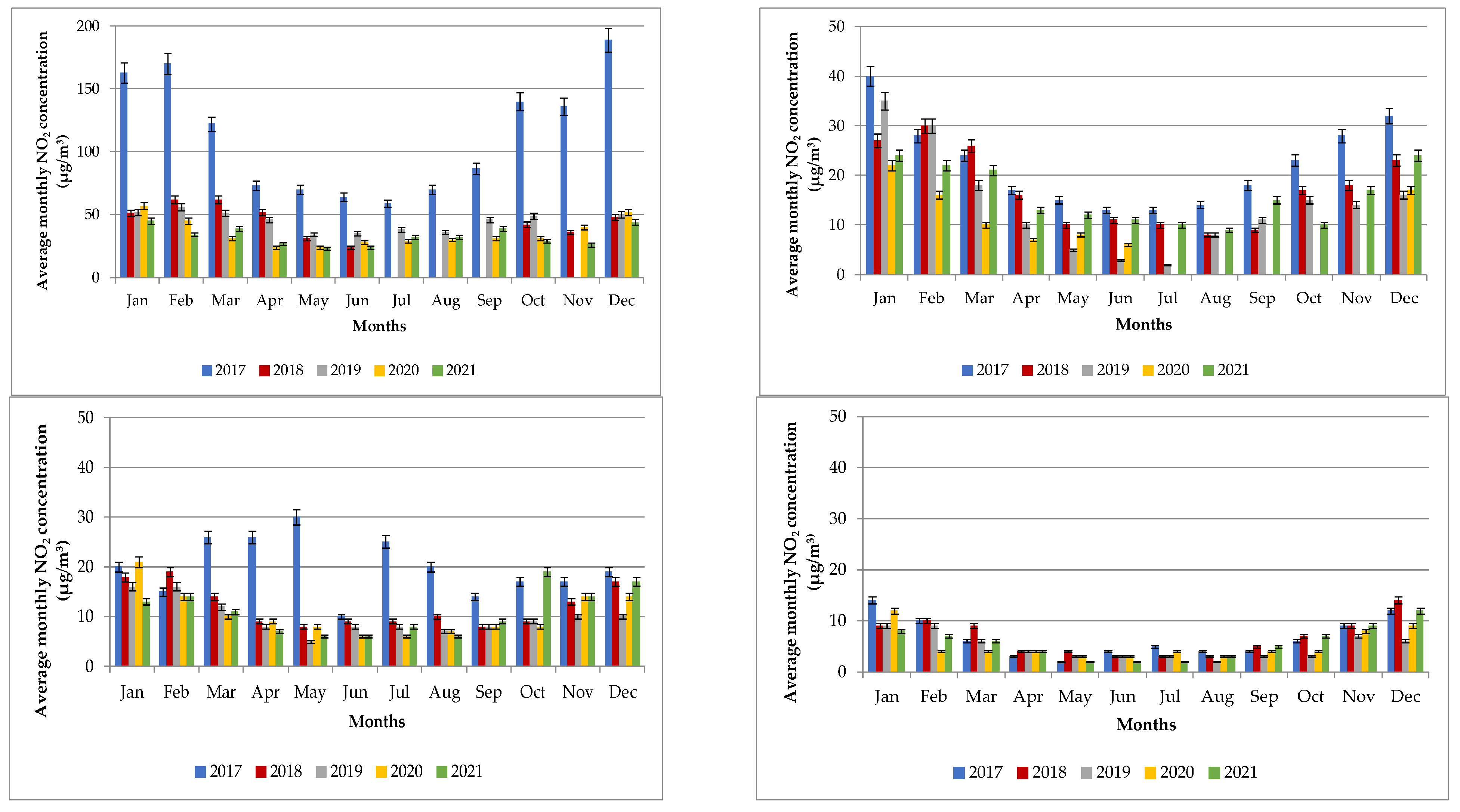
Figure 4 shows average monthly NO2 concentrations at studied locations throughout the years. Average monthly NO2 concentrations at location A were 111.92 ± 5.97 µg/m3 in 2017, 34.00 ± 1.70 µg/m3 in 2018, 41.08 ± 2.05 µg/m3 in 2019, 35.16 ± 1.76 µg/m3 in 2020, and 32.83 ± 1.64 µg/m3 in 2021. The highest average monthly SO2 concentration was in the year 2017 (189.00 ± 9.45 µg/m3), whereas the lowest was in the year 2018 and 2019 (0.00 ± 0.00 µg/m3). In 2017, the highest average monthly concentration was detected in December (189.00 ± 9.45 µg/m3), whereas the lowest average monthly concentration was detected in July (59.00 ± 2.95 µg/m3). In 2018, the highest average monthly concentration was detected in February and March (62.00 ± 3.10 µg/m3), while the lowest average monthly concentration was detected in July, August, and September (0.00 + 0.00 µg/m3). Average monthly SO2 concentrations at location B were 22.08 ± 1.10 µg/m3 in 2017, 17.08 ± 0.85 µg/m3 in 2018, 13.92 ± 0.69 µg/m3 in 2019, 7.16 ± 0.36 µg/m3 in 2020, and 15.67 ± 0.78 µg/m3 in 2021. Average monthly NO2 concentration at location B was the highest in the year 2017 (40.00 ± 2.00 µg/m3), whereas the lowest was detected in the year 2020 (0.00 ± 0.00 µg/m3). In 2017, the highest average monthly concentration was detected in January (40.00 ± 2.00 µg/m3), whereas the lowest average monthly concentration in that year was detected in June and July (13.00 ± 0.65 µg/m3). In 2020, the highest average monthly concentration of 22.00 ± 1.10 µg/m3 was detected in January, whereas during other months, the average monthly concentration varied from 0.00 ± 0.00 µg/m3 to 17.00 ± 0.85 µg/m3. Average monthly NO2 concentrations at location D were 7.00 ± 0.35 µg/m3 in 2017, 21.00 ± 1.05 µg/m3 in 2018, 13.42 ± 0.67 µg/m3 in 2019, 15.08 ± 0.75 µg/m3 in 2020, and 13.58 ± 0.68 µg/m3 in 2021. The highest average monthly NO2 concentration was in 2017 (30.00 ± 1.50 µg/m3), whereas the lowest was in the year 2019 (5.00 ± 0.25 µg/m3). In 2017, the highest average monthly concentration was detected in May (30.00 ± 1.50 µg/m3), the lowest average monthly concentration was detected in September that year (14.00 ± 0.70 µg/m3). In 2019, the highest average monthly concentration was detected in January and February (16.00 ± 0.80 µg/m3), and the lowest average monthly concentration was detected in May (5.00 ± 0.25 µg/m3). Average monthly NO2 concentrations at location E were 6.58 ± 0.32 µg/m3 in 2017, 6.67 ± 0.33 µg/m3 in 2018, 4.83 ± 0.24 µg/m3 in 2019, 5.17 ± 0.26 µg/m3 in 2020, and 5.58 ± 0.28 µg/m3 in 2021. The highest average monthly NO2 concentration was in the year 2017 (14.00 ± 0.70 µg/m3), whereas the lowest was in the year 2019 and 2021 (2.00 ± 0.10). Again, the highest average monthly concentrations of NO2 were detected in January, December, and February, whereas the lowest average monthly concentrations were detected during summer months.
Figure 5 shows average annual NO2 concentrations at studied locations between 2017 and 2021. Average annual NO2 concentrations were the highest at location A (50.00 ± 2.50 µg/m3) in 2017, while the lowest were detected at location E (5.00 ± 0.25 µg/m3) in 2019, 2020, and 2021.
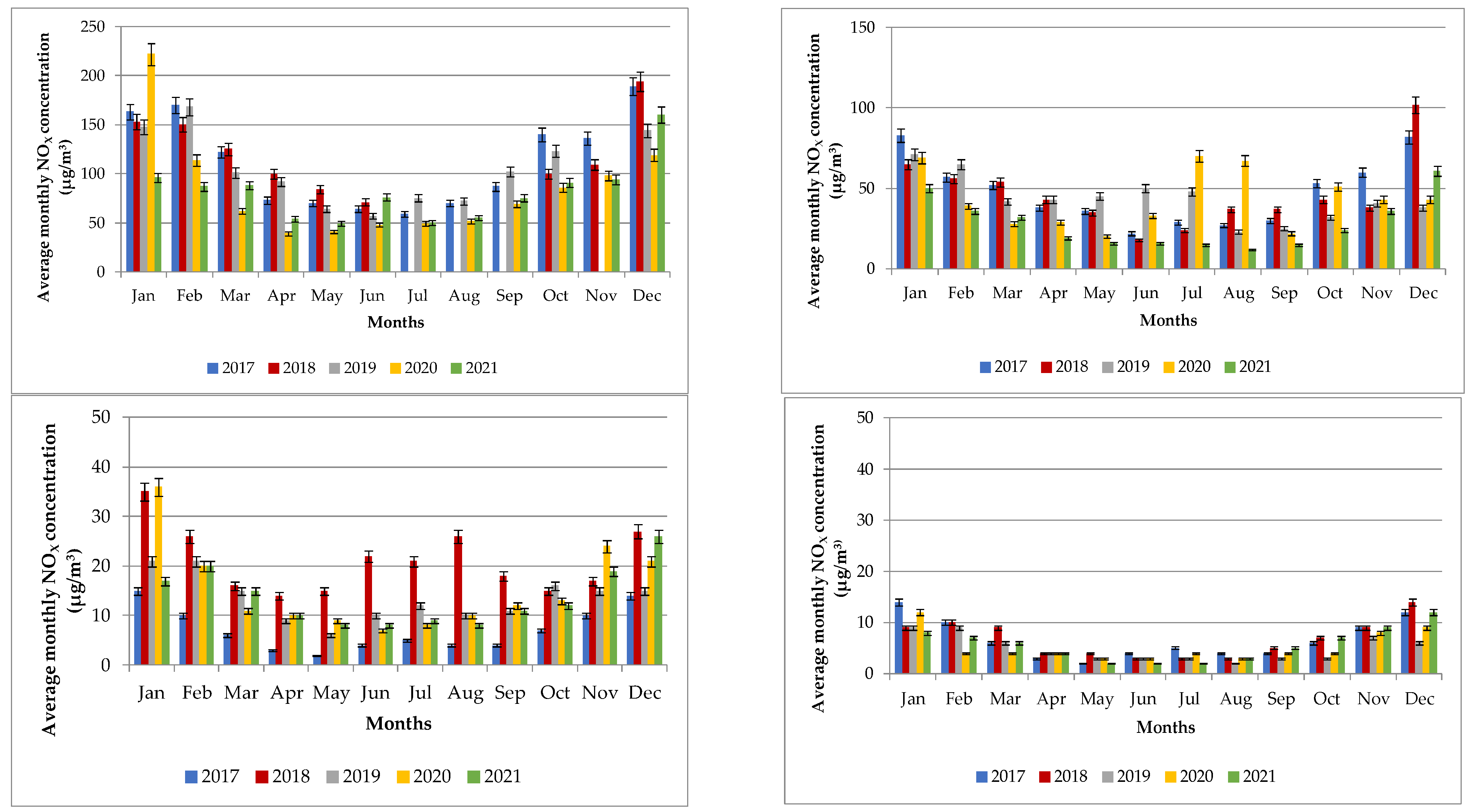
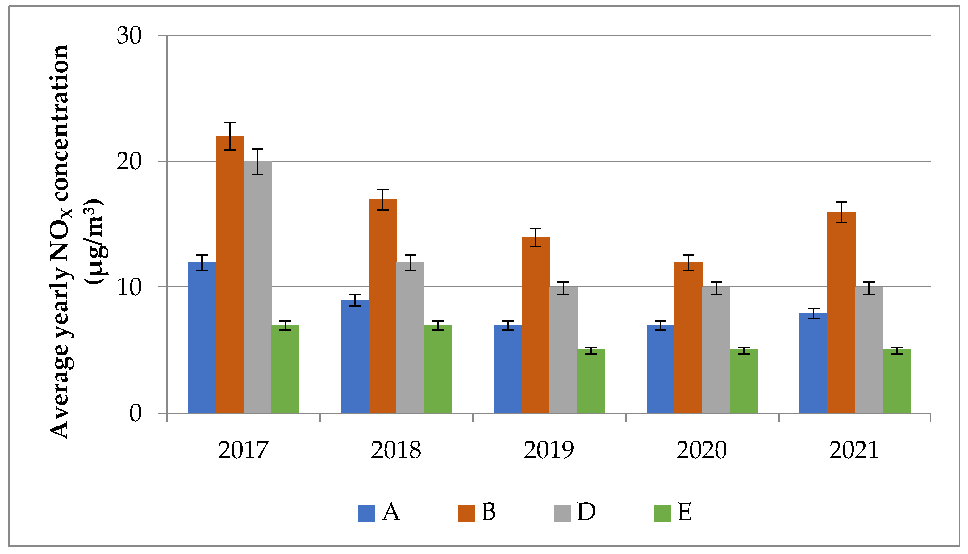
In addition, Figure 6 and Figure 7 present the average monthly and annual NOX concentrations at chosen locations during studied years, and Table 2 shows average, minimal, and maximal values with standard deviation. The plots for daily average concentrations of NOX at all locations during the study period are in the SM (Figure S3). Average, minimum, and maximum values with standard deviations for all studied years for each pollutant are additionally included (SM, Table S3).
NO2 and NOX concentration levels have a characteristic daily and annual course [17]. The highest NO2/NOX concentration levels were detected in 2017 at all locations, whereas the lowest were detected in the year 2020 and 2021. It is believed that changes in the average annual levels of NO2/NOX through the years may be a consequence of meteorological conditions. At all measuring points, the lowest levels are measured in the summer months when the weather conditions for the dilution of emissions are more favorable. During this period, emissions of nitrogen oxides are also lower due to reduced traffic (permits, holidays, and an increased use of bicycles). Levels of nitrogen oxides are highest in winter when the atmosphere is the least stable and the worst ventilated, and discharges are slightly higher than in the summer [17]. Furthermore, the concentration levels in 2020 and 2021 have also been affected by the COVID-19 pandemic and measures set by the Slovenian government. In the RS, two official lockdowns occurred (12 March–31 May 2020 and 18 October–31 December 2020). During the lockdowns, the Slovenian government imposed strict measures and control policies to preserve the health and safety for Slovenian citizens, such as closing public institutions, working and schooling from home, or cancelling all public events. Furthermore, public transportation and travel in and out of the country were shut down; therefore, there was significantly less traffic (road, railway, or even aviation) [14] leading to less NO2/NOX emissions.

3.3. PM10 and PM2.5 Concentrations between 2017 and 2021

Elevated levels of PM10 and PM2.5 particles typically occur in the RS in the wintertime when weak winds in the ground layers occur (so-called temperature reversal), such as in the case of anticyclone conditions. In these layers, there is a weak vertical mixing of the air, which causes the pollutants to stay close to the ground for a long time. At the same time, small fireplaces are the most active during the wintertime, with the largest contribution to PM10 and PM2.5 particulate emissions. Furthermore, transport is a major source of pollution with the smallest particles, especially in areas with high traffic density.
The limit value for the daily maximum average of PM10 in the RS is 50 µg/m3 and must not be exceeded by more than 35 times per year. The same value is proposed by the WHO [7]. The average annual limit value is set to 40 µg/m3 in the RS, whereas the WHO proposed this value to be 20 µg/m3 [7,17]. The limit value for the daily maximum average of PM2.5 in the RS is not determined, whereas the WHO proposed this value to be 25 µg/m3. The average annual limit value in the RS is 20 µg/m3, which the WHO proposed instead to be 10 µg/m3.
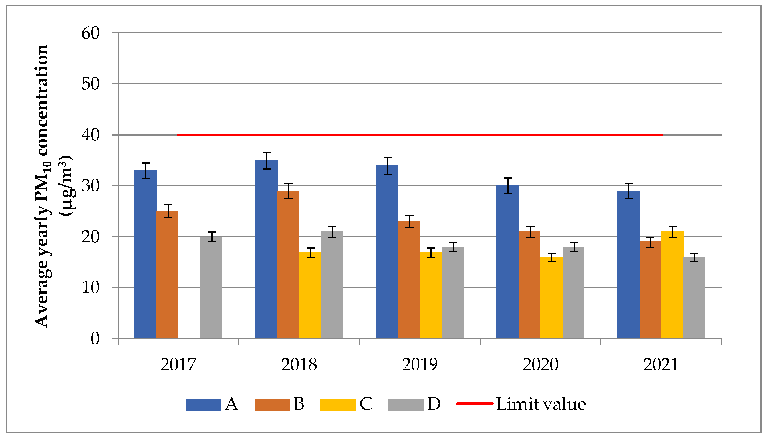
The PM10 parameter was studied during the period from 2017 to 2021 at four locations (A, B, D), and the data availability was more than 85% at all locations. Concentration levels of PM10 were not monitored at location E. The plots for daily average concentrations of PM10 at all locations during the study period are in the SM (Figure S3). Average, minimum, and maximum values with standard deviations for all studied years for each pollutant are additionally added (SM, Table S3). From the daily average data, it can be observed that the PM10 concentrations were the lowest at location C in the year 2019 (14.95 ± 0.75 µg/m3), while the highest were at location A in the year 2017 (35.48 ± 1.77 µg/m3). Location A is located very closely to a road with significant daily traffic, which coincides with the obtained average value.
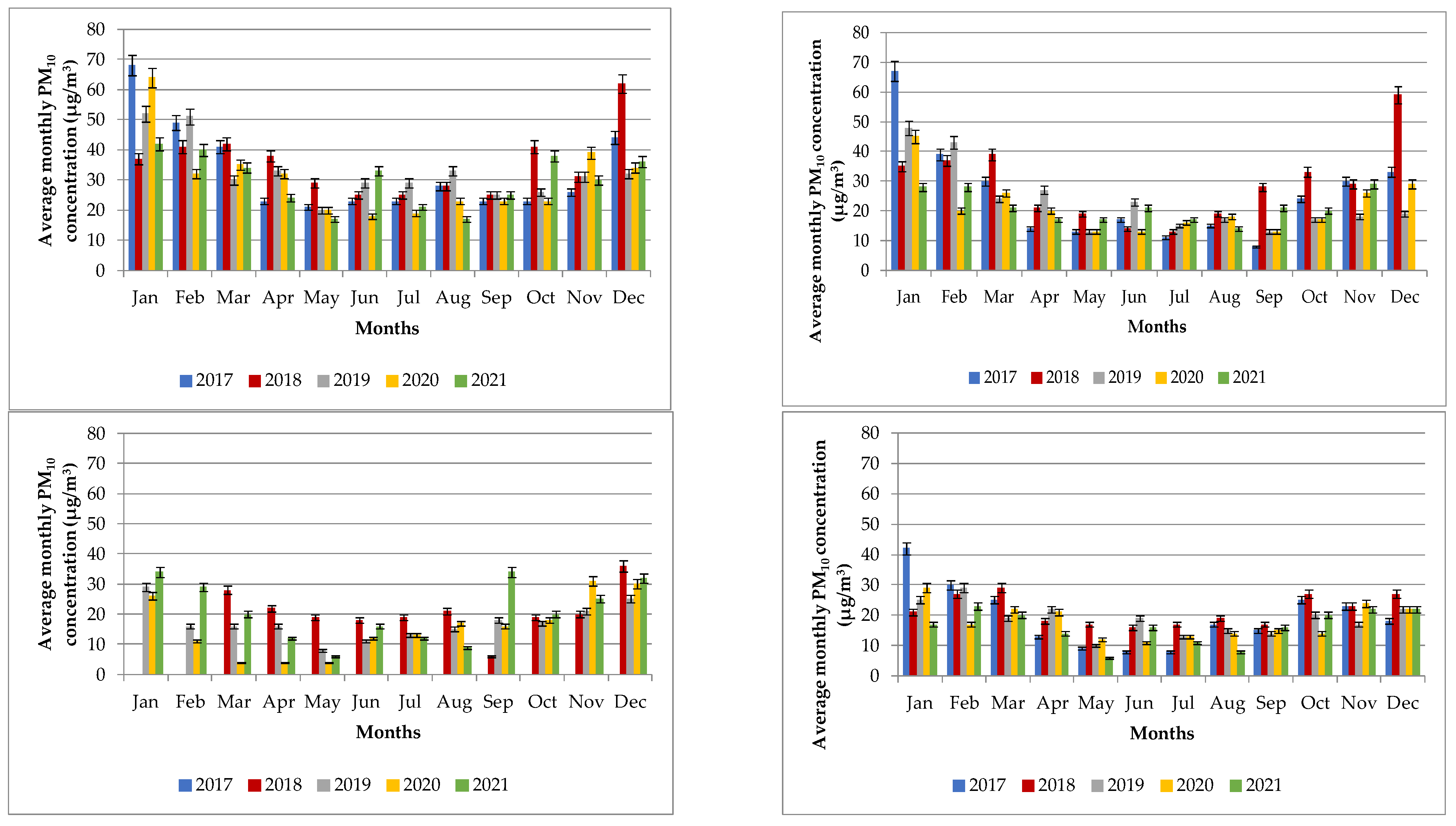
Figure 8 shows average monthly PM10 concentrations at studied locations throughout the years. Average monthly PM10 concentrations at location A were 32.66 ± 1.63 µg/m3 in 2017, 35.33 ± 1.706 µg/m3 in 2018, 32.58 ± 1.63 µg/m3 in 2019, 30.16 ± 1.50 µg/m3 in 2020, and 29.75 ± 1.49 µg/m3 in 2021. Average monthly concentrations were nearly the same throughout the studied years (< 10%). The highest average monthly PM10 concentration was detected in January 2017 (64.00 ± 3.20 µg/m3), whereas the lowest average monthly PM10 concentration was detected in May and August 2021 (17.00 ± 0.85 µg/m3). Average monthly PM10 concentrations at location B were 25.08 ± 1.25 µg/m3 in 2017, 28.83 ± 1.44 µg/m3 in 2018, 23.08 ± 1.15 µg/m3 in 2019, 21.33 ± 1.06 µg/m3 in 2020, and 19.42 ± 0.97 µg/m3 in 2021. The average monthly PM10 concentration at location B was the highest in January 2017 (67.00 ± 3.35 µg/m3), whereas the lowest was detected in September 2017 (8.00 ± 0.40 µg/m3). Due to an incorrect operation in the measuring system, the measurements were not established for December 2021. Automatic continuous measurements of PM10 at location C started in March 2018. Average monthly PM10 concentrations at this location were therefore 17.33 ± 0.86 µg/m3 in 2018, 17.08 ± 0.85 µg/m3 in 2019, 15.5 ± 0.78 µg/m3 in 2020, and 20.75 ± 1.04 µg/m3 in 2021. Average monthly PM10 concentration at location B was the highest in January and September 2021 (34.00 ± 1.70 µg/m3), whereas the lowest was detected in March, April, and May 2020 (4.00 ± 0.20 µg/m3). Average monthly PM10 concentrations at location D were 19.42 ± 0.97 µg/m3 in 2017, 21.50 ± 1.08 µg/m3 in 2018, 18.75 ± 0.94 µg/m3 in 2019, 17.83 ± 0.89 µg/m3 in 2020, and 16.25 ± 0.81 µg/m3 in 2021. Average monthly concentrations were nearly the same through the studied years. The highest average monthly PM10 concentration was detected in January 2017 (42.00 ± 2.10 µg/m3), whereas the lowest average monthly PM10 concentration was detected in May 2021 (6.00 ± 0.30 µg/m3).
Figure 9 additionally shows average annual PM10 concentrations at studied locations between 2017 and 2021. Average annual PM10 concentrations were the highest at location A (50.00 ± 2.50 µg/m3) in 2017, while the lowest were detected at location E (5.00 ± 0.25 µg/m3) in 2019, 2020, and 2021.
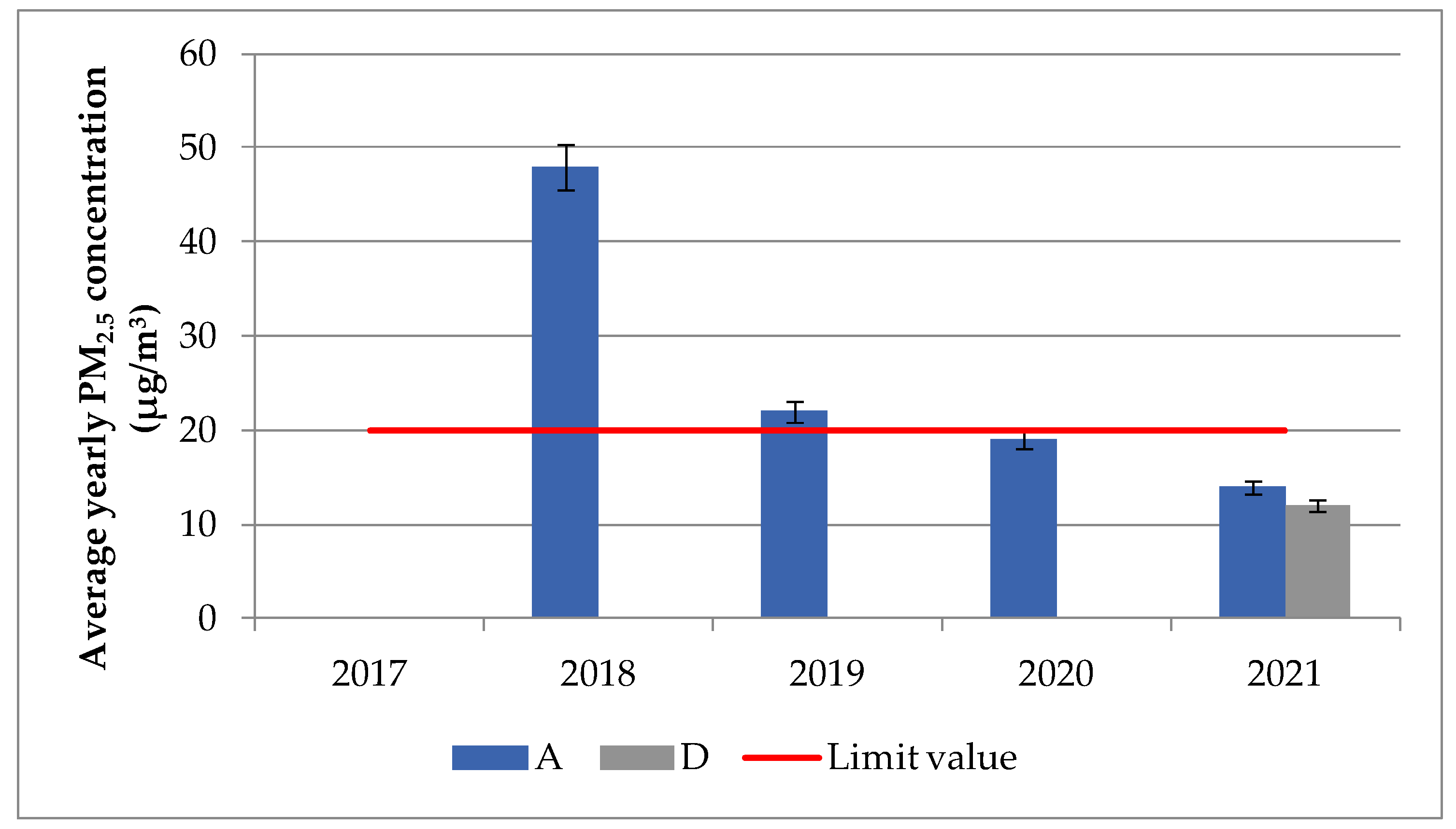
The PM2.5 parameter was studied during the period from 2017 to 2021 at only two locations (A and D). The data availability was more than 70% at both locations. At other monitoring stations, the measurements of PM2.5 were not established. The plots for daily average concentrations of PM2.5 at these two locations during the study period are in the SM (Figure S4). Average, minimum, and maximum values with standard deviations are additionally included (SM, Table S4).
At location A, the measurements were established in April 2018. Average monthly PM2.5 concentrations at this location were 13.58 ± 0.80 µg/m3 in 2018, 21.50 ± 1.08 µg/m3 in 2019, 19.00 ± 0.95 µg/m3 in 2020, and 14.16 ± 0.71 µg/m3 in 2021. The highest average monthly PM2.5 concentration was detected in January 2020 (57.00 ± 2.85 µg/m3), whereas the lowest average monthly PM2.5 concentration was detected in May 2021 (6.00 ± 0.30 µg/m3). Due to an incorrect operation in the measuring system, the measurements were not established for December 2021. At location D, the measurements of PM2.5 were established until 2021. Therefore, the average monthly PM2.5 concentration in 2021 was 12.00 ± 0.60 µg/m3. The highest average monthly concentration was detected in November and December 2021 (20.00 ± 1.00 µg/m3), whereas the lowest was detected in May 2021 (2.00 ± 0.10 µg/m3) (Figure 10). Figure 11 additionally shows average annual PM2.5 concentrations at locations A and D between 2017 and 2021.
To sum up, concentration levels of PM10 and PM2.5 were higher during the cold period of the year compared to spring and summer seasons. The difference between autumn/winter and spring/summer concentration levels has been calculated to be around 15%. The concentration levels of PM10 and PM2.5 between 2018 and 2020 were already studied by the same authors in our previous work [14]. Before 2018 and 2021, the concentrations values were negligible. The year 2021 was still marked with the COVID-19 pandemic, and thus obtained values may be affected by it. It was similarly found in other works [23,24].

3.4. Correlation between NOX and NO2 during 2019 and 2020

Table 3 shows the correlation coefficients between daily NOX and NO2 parameters between the years 2019 and 2020, as these two years represent a mark in analyzing air quality in the RS due to the COVID-19 pandemic. In addition, the year 2021 was added to obtain representative results. Pearson’s correlation coefficient was studied according to the following works [25,26] and results are presented based on the location and studied year. In addition, during these two years, the concentration levels of nitrogen oxides were studied between weekdays and weekends and the main findings are presented.
From the obtained results, it can be observed that NO2 and NOX have a positive correlation coefficient between each other. At location A in 2019, 2020, and 2021, the correlation coefficients were found to be 0.84, 0.93, and 0.94. Similarly, at location B, those values were found to be 0.73 in 2019, 0.72 in 2020, and 0.81 in 2021. At location D in 2019, 2020, and 2021, the correlation coefficients were found to be 0.82, 0.93, and 0.89, and finally, at location E, they were 0.80 in 2019, 0.69 in 2020, and 0.72 in 2021. The results are similar to the ones in the literature [27,28] and previously mentioned works, and they imply a significant correlation between the studied parameters.
Furthermore, in SM, Figure S6 shows the daily course of the average hourly NO2 concentration levels at measuring points during 2019 and 2020 to determine the difference in concentration levels between weekdays and weekends. The daily trend of NO2 shows that the first period of higher concentration levels occur at all measuring points during the morning traffic rush due to increased emissions from traffic. In the afternoon or in the evening, another increase occurs as a result of the atmosphere calming down in the layer of air near the ground, which is more or less pronounced at different measuring points. The highest concentration levels were detected at measuring location A, which is classified as traffic location. The lowest concentrations were detected at measuring location E. On weekdays, the levels are higher for most of the day due to more intense traffic, while on weekends, the highest values were recorded in the evening hours. Other works confirmed similar conclusions [29,30].

3.5. Correlation between PM10 and PM2.5

The term particle matter is a general term that means suspended particles (liquid solids) in gas. With the term PM2.5, fine particles that have an aerodynamic diameter of less than 2.5 µm are described, and with the term PM10, particles with an aerodynamic diameter of less than 10 µm are described. Regarding the origin, the particles can be primary and secondary, natural or of anthropogenic origin. Natural sources are primarily a consequence of the intake of sea salt, natural re-suspension of oils, desert dust, and flower dust, whereas anthropogenic sources include emissions not related to fuel combustion in thermal energy facilities and industry, with heating of apartments and other buildings, and traffic [5].
The correlation coefficient between PM10 and PM2.5 was studied based on the work of Talbi et al. [31], Usman et al. [32], and Truong et al. [33], again between the years 2019, 2020, and 2021. Obtained results are presented based on the location and studied year. In addition, during these two years, the concentration levels of PM were studied between heating seasons, and the main findings are presented.
The correlation coefficients during the study period are shown in Table 4. At location A in 2019, the correlation coefficient was 0.95, while at location B was a little lower, at 0.92. In 2020, the correlation coefficient at location A was 0.94, the same was found in the year 2021. At location B, the correlation coefficient was 0.92 in 2020 and 0.77 in 2021.
From the obtained results, it can be concluded that particulate matter have a positive and significant correlation coefficient between each other.
In SM, Figure S7 shows the daily course of the average hourly PM10 and PM2.5 concentration levels at locations A, C, and D during the heating season of 2019 and 2020. Heating season is between October and March the following year. The highest concentration levels were detected during morning and evening hours at all locations. The evening maximum is more pronounced, when the traffic rush is joined by discharges due to heating, but at the same time, a temperature reversal begins to form in the evening and consequently decreases the dilution of polluted air.

3.6. Meteorological Conditions

Jiaxin et al. [34] stated that air quality depends on pollution emissions and regional meteorological conditions. Changes in meteorological conditions can affect the physical processes and chemical reactions of pollutants [35,36]. Wind speed and direction can affect the diffusion and transmission of pollutants, while temperature and humidity can affect pollutant reaction processes [14].
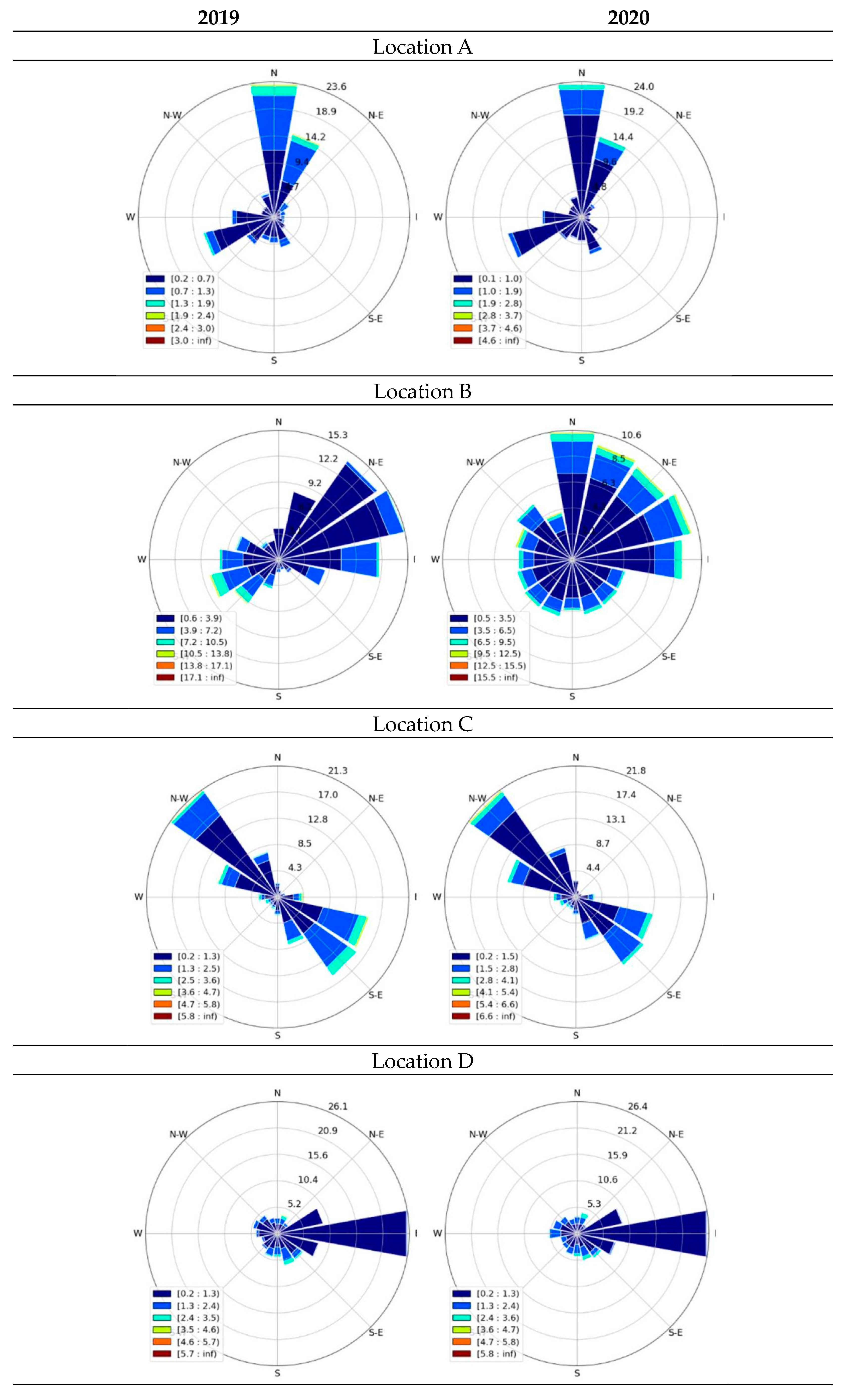
Meteorological data were studied in details between the years 2019 and 2020 to better understand the impact of metrology on the concentration levels of studied air pollutants. According to the meteorological data, the mean annual average temperature in 2019 on location A was 12.66 ± 0.63 °C, on location B 12.61 ± 0.63 °C, on location C 12.14 ± 0.61 °C, on location D 11.62 ± 0.58 °C, and on location E 22.33 ± 1.12 °C. The average annual relative humidity (RH) was 65.94 ± 3.29%, 78.46 ± 3.92%, 80.91 ± 4.05%, respectively. In the year 2020, the average annual temperature was 12.21 ± 0.61 °C, 12.04 ± 0.60 °C, 11.65 ± 0.58 °C, 10.76 ± 0.53 °C, and 23.50 ± 1.18 °C, respectively, at each location, whereas RH was 64.25 ± 3.21%, 77.08 ± 3.85%, 80.41 ± 4.02%, respectively. On location C and E, RH was not monitored during the studied years. In SM, Figure S6 shows the plots of temperature and RH for studied years at each location. Moreover, Figure 12 shows wind roses for each location and each studied year. As stated in our previous work [14], the wind conditions in the RS are influenced by its varied relief, location, and the Alps. Normally, the wind blows from a westerly direction. Compared to Western Europe, the RS is not as windy, as it is located in the lee of the Alps [3]. Average wind speeds at location A were 1.30 ± 0.07 m/s in 2019 and 2020, at location B were 1.70 ± 0.85 m/s in 2019 and 2020, at location C were 0.90 ± 0.05 m/s in 2019 and 1.00 ± 0.05 m/s, and at locations D and E were 1.50 ± 0.08 m/s in 2019 and 2020. During both years, north-east winds dominated location A, east winds dominated location B, north-west winds dominated location C, and east winds dominated both locations D and E. Based on these findings, it can be concluded that changes in temperature, relative humidity, wind speed, and wind direction were negligible at all locations during both studied years (<5%).

3.7. Emission Sources in the Republic of Slovenia

Today, the largest sources of SOX in the RS are still the production of electricity and thermal energy, industrial processes, and the use of fuels in industry. In the past, the largest source was the use of coal for heating households. The annual SOX emissions in the RS in 2020 were approximately 4.0 thousand tons, and, compared to the year 1980, those emissions decreased by as much as 98% [17]. The reduction of discharges is mainly due to the installation of desulfurization devices in thermal power plants, the use of coal with a lower sulfur content, and the replacement of liquid and solid fuels in industry with natural gas. The largest share of total SOx emissions in 2020 was contributed by thermal power plants and heating plants, which was 37%, followed by industrial processes with 32% [17].
Annual emissions of NOX in the RS are roughly 34 thousand tons [17]. By the year 2019, they decreased by approximately 60%. The largest source of NOX emissions represented road traffic as it contributed as much as 47% to the total national emissions. NO2 concentrations have characteristic annual and daily levels. At all measuring points, the lowest levels are measured in the summer months when the weather conditions for the dilution of emissions are more favorable. During this period, emissions of nitrogen oxides are also lower due to reduced traffic. Levels of NO2 are usually the highest in winter when the atmosphere is the worst ventilated. During the morning rush hour, the levels of NO2 are the highest due to increased emissions from traffic, and the same can be stated for the “after work” rush hours. Therefore, on weekdays, the values are the highest during the day due to the more intensive traffic, while during weekends, the highest values are recorded in the evening. The year 2020 was marked by the COVID-19 pandemic. Due to the movement restriction, home working and schooling were restricted, and road traffic subsequently decreased. Especially in March and April, the NOX emissions from traffic decreased throughout Europe, and, consequently, NO2 levels decreased in urban and suburban environments [14,24]. The NO2 concentrations in the RS were at the lowest measuring point in 2020 compared to previous years (<50 wt.%).
Furthermore, the epidemiological studies show that PM10 and PM2.5 have the most negative impact in terms of air pollution [11,37]. Reports from the WHO indicate that there is no limit below which no health effects are expected [20,38]. The impact on health is caused by the inhalation of particles and resulting invasion into the lungs and blood, which causes damage to the respiratory, cardiovascular, immune, and nervous systems [37]. The smaller the particles, the deeper they can penetrate into the lungs until inflammation or tissue damage occurs due to both chemical and physical interactions between the particles and the tissue. In addition to the negative impact on health, particle pollution has an impact on the climate and ecosystem [16]. Annual emissions of PM10 particles in 2019 amounted to 13 thousand tons, and annual emissions of PM2.5 were approximately 11 thousand tons. It has been stated by the ARSO [5] that in the period 2000–2019, emissions of PM10 and PM2.5 were reduced by 25%. The reduction in emissions is the result of the improvement of energy efficiency and combustion processes, the modernization of technological processes, the replacement of solid fossil fuels with natural gas and renewable energy sources, and the introduction of stricter emission regulations standards for motor vehicles. In 2019, small fireplaces caused around 60% of emissions at the national level, PM10 and PM2.5 emissions from road traffic represented 8% and 7% of total national emissions, respectively, and PM2.5 emissions were 7%. In March 2020, those values were generally lower. In 2020, a high amount of Sahara dust came across the country, causing the concentrations of PM10 and PM2.5 to jump higher than 100 µg/m3.

4. Conclusions

From the daily average data, it can be observed that SO2 concentrations were the lowest in the year 2021 at location B, which is classified as background location, while the highest were detected in the year 2018 at location E, which is also classified as background location. The average daily concentrations of NO2 and NOX daily average were the highest at location A in the year 2017, whereas the lowest were detected in the years 2010 and 2021. It is believed that those results are a consequence of measures set by the Slovenian government during the COVID-19 epidemic. The PM10 and PM2.5 daily average concentrations were the highest at location A in 2017, and the lowest were observed in the year 2019 at location C. In total, the daily, monthly, and annual concentrations for all the studied parameters decreased from 2017 to 2021 at all studied locations, even though some anomalies occurred. There are several reasons for such results: updated laws and standards in the EU and the RS, meteorological conditions, the COVID-19 pandemic and its set measures, natural sources such as Saharan dust, etc. Furthermore, the results from meteorological data showed a connection to the concentrations obtained from all the air pollutants. The average annual temperatures were around 12 °C at all locations during all studied years, average wind speeds were around 1.30 m/s at all locations during all studied years, while the average relative humidity was approximately 75%. The correlation coefficients showed a link between the NO2 and NOX parameters and between the PM10 and PM2.5 parameters, respectively.
The obtained data showed a decrease in average concentrations for all the studied parameters, confirming the positivity of the measures set by the Slovenian government. The potential sources of pollution are still traffic (mostly road and railway), agricultural residue burning, coal, biomass, and industry; therefore, the obtained data could be used in the future when national strategies regarding air quality are updated and improved. In the future, the work will focus on analyzing the quartile and seasonal changes in concentration levels of studied parameters, as well meteorological parameters, which will include levels of rain fall during the study period. The correlation between meteorological conditions and particulate matter will be studied in detail in addition to ozone and VOCs concentration levels.

Supplementary Materials

The following supporting information can be downloaded at: https://www.mdpi.com/article/10.3390/atmos14030578/s1, Figure S1: Average daily SO2 concentrations at locations (A–E) between 2017 and 2021; Figure S2: Average daily NO2 concentrations at locations (A–E) between 2017 and 2021; Figure S3: Average daily NOX concentrations at locations (A–E) between 2017 and 2021; Figure S4: Average daily PM10 concentrations at locations (A–E) between 2017 and 2021; Figure S5: Average daily PM2.5 concentrations at locations (A–E) between 2017 and 2021; Figure S6: Daily course of the average hourly NO2 concentration levels at measuring points between 2019 and 2020; Figure S7: Daily course of the average hourly PM10 concentration levels during the heating season 2019 and 2020; Figure S8: Plots of temperature and RH at locations (A–E) between 2019 and 2020; Table S1: Average, minimum, and maximum daily SO2 concentrations (µg/m3) at all locations between 2017 and 2021; Table S2: Average, minimum, and maximum daily NO2 concentrations (µg/m3)at all locations between 2017 and 2021; Table S3: Average, minimum, and maximum daily NOX concentrations (µg/m3) at all locations between 2017 and 2021; Table S4: Average, minimum, and maximum daily PM10 concentrations (µg/m3) at all locations between 2017 and 2021; Table S5: Average, minimum, and maximum daily PM2.5 concentrations (µg/m3) at all locations between 2017 and 2021.

Author Contributions

Conceptualization, methodology, software, validation, investigation, formal analysis, writing—original draft: M.I.; software, validation, investigation, writing—original draft K.A.; methodology, validation, formal analysis, writing—review and editing, supervision: D.U.; supervision: M.S., supervision: D.G.; supervision: R.V. All authors have read and agreed to the published version of the manuscript.

Funding

This research received no external funding.

Institutional Review Board Statement

Not applicable.

Informed Consent Statement

Not applicable.

Data Availability Statement

Not applicable.

Conflicts of Interest

The authors declare no conflict of interest.

Abbreviations

ARSOSlovenian Environment Agency
EEAEuropean Environment Agency
EUEuropean Union
EIMVElektroinštitut Milan Vidmar
NIJZNational Institute for Public Health
SMSupplementary Materials
RSRepublic of Slovenia
WHOWorld Health Organization

References

  1. World Health Assembly, 71. Health, Environment and Climate Change: Report by the Director-General; World Health Organization: Geneva, Switzerland, 2018; Volume 2016, pp. 1–7. [Google Scholar]
  2. Jesemann, A.; Matthias, V.; Böhner, J. Using Neural Network NO2-Predictions to Understand Air Quality Changes in Urban Areas—A Case Study in Hamburg. Atmosphere 2022, 13, 1929. [Google Scholar] [CrossRef]
  3. Pucer, J.F.; Strumbelj, E. Impact of Changes in Climate on Air Pollution in Slovenia between 2002 and 2017. Environ. Pollut. 2018, 242, 398–406. [Google Scholar] [CrossRef] [PubMed]
  4. Zheng, H.; Yang, Z.; Yang, J.; Tao, Y.; Zhang, L. Comprehensive Evaluation of Environmental Air Quality Based on the Entropy Weights and Concentration Variation Trends of Pollutants. Atmosphere 2022, 13, 1978. [Google Scholar] [CrossRef]
  5. Gjerek, M.; Koleša, T.; Logar, M.; Matevž, L.; Murovec, M.; Rus, M.; Žabkar, R. Kakovost Zraka v Sloveniji v Letu 2020; Agencija Republike Slovenia za Okolje: Ljubljana, Slovenia, 2021. Available online: https://www.arso.gov.si/zrak/kakovost%20zraka/poro%C4%8Dila%20in%20publikacije/kakovost_letna.html (accessed on 8 March 2023).
  6. European Environment Agency (EEA). Air Quality in Europe—2020 Report; European Environment Agency (EEA): Copenhagen, Denmark, 2020; Available online: https://www.eea.europa.eu/publications/air-quality-in-europe-2020-report (accessed on 8 March 2023).
  7. World Health Organization (WHO). WHO Global Air Quality Guidelines, Update 2021; World Health Organization: Geneva, Switzerland, 2021; Available online: https://www.who.int/health-topics/air-pollution#tab=tab_1 (accessed on 8 March 2023).
  8. Brauer, M.; Casadei, B.; Harrington, R.A.; Kovacs, R.; Sliwa, K.; Davaakhuu, N.; Hadley, M.; Kass, D.; Miller, M.; Consuelo Escamilla Nuñez, M.; et al. Taking a Stand Against Air Pollution—The Impact on Cardiovascular Disease: A Joint Opinion from the World Heart Federation, American College of Cardiology, American Heart Association, and the European Society of Cardiology. J. Am. Coll. Cardiol. 2021, 77, 1684–1688. [Google Scholar] [CrossRef] [PubMed]
  9. Cohen, A.J.; Brauer, M.; Burnett, R.; Anderson, H.R.; Frostad, J.; Estep, K.; Balakrishnan, K.; Brunekreef, B.; Dandona, L.; Dandona, R.; et al. Estimates and 25-Year Trends of the Global Burden of Disease Attributable to Ambient Air Pollution: An Analysis of Data from the Global Burden of Diseases Study 2015. Lancet 2017, 389, 1907–1918. [Google Scholar] [CrossRef] [PubMed] [Green Version]
  10. Pandey, A.; Brauer, M.; Cropper, M.L.; Balakrishnan, K.; Mathur, P.; Dey, S.; Turkgulu, B.; Kumar, G.A.; Khare, M.; Beig, G.; et al. Health and Economic Impact of Air Pollution in the States of India: The Global Burden of Disease Study 2019. Lancet Planet. Health 2021, 5, e25–e38. [Google Scholar] [CrossRef]
  11. Maftei, C.; Muntean, R.; Poinareanu, I. The Impact of Air Pollution on Pulmonary Diseases: A Case Study from Brasov County, Romania. Atmosphere 2022, 13, 902. [Google Scholar] [CrossRef]
  12. World Health Organization (WHO). Air Quality Guidelines, Global Update 2005; World Health Organization: Geneva, Switzerland, 2006; Available online: https://apps.who.int/iris/handle/10665/107823 (accessed on 8 March 2023).
  13. Gjerek, M.; Koleša, T.; Logar, M.; Matevž, L.; Murovec, M.; Rus, M.; Žabkar, R. Kakovost Zraka v Sloveniji v Letu 2017; Agencija Republike Slovenia za Okolje: Ljubljana, Slovenia, 2018; Volume 127. Available online: https://www.arso.gov.si/zrak/kakovost%20zraka/poro%C4%8Dila%20in%20publikacije/kakovost_letna.html (accessed on 8 March 2023).
  14. Ivanovski, M.; Lavrič, P.D.; Vončina, R.; Goričanec, D.; Urbancl, D. Improvement of Air Quality during the COVID-19 Lockdowns in the Republic of Slovenia and Its Connection with Meteorology. Aerosol Air Qual. Res. 2022, 22, 1–17. [Google Scholar] [CrossRef]
  15. Nacionalni Inštitut za javno zdravje (NIJZ). Ocena Vpliva Onesnaženosti Zraka z Delci (PM) Na Umrljivost v Slovenskih Krajih; Nacionalni Inštitut za Javno Zdravje (NIJZ): Ljubljana, Slovenia, 2018; Available online: https://nijz.si/moje-okolje/zrak/ocena-vpliva-onesnazenosti-zraka-z-delci-pm25-na-umrljivost-v-krajih-s-prekomerno-onesnazenim-zrakom-opazovalno-obdobje-2017-2019/ (accessed on 8 March 2023).
  16. Ivanovski, M.; Dolšak Lavrič, P.; Miklavčič, N.; Kovačič, D.V.R. Rezultati Meritev Okoljskega Merilnega Sistema Mestne Občine Celje—AMP Gaji: Leto 2020: Študija Št. 2475; Elektroinštitut Milan Vidmar: Ljubljana, Slovenia, 2021; Available online: http://www.okolje.info/index.php/arhiv-porocil (accessed on 8 March 2023).
  17. Bec, D.; Ciglenički, D.; Dolšak Lavrič, P.; Gjerek, M.; Koleša, T.; Logar, M.; Matavž, L.; Murovec, M.; Rus, M.; Žabkar, R. Kakovost Zraka v Republiki Sloveniji v Letu 2021; Agencija Republike Slovenia za Okolje: Ljubljana, Slovenia, 2021. Available online: https://www.arso.gov.si/zrak/kakovost%20zraka/poro%C4%8Dila%20in%20publikacije/kakovost_letna.html (accessed on 8 March 2023).
  18. Shi, J.; Liu, S.; Qu, Y.; Zhang, T.; Dai, W.; Zhang, P.; Li, R.; Zhu, C.; Cao, J. Variations of the Urban PM2.5 Chemical Components and Corresponding Light Extinction for Three Heating Seasons in the Guanzhong Plain, China. J. Environ. Manag. 2023, 327, 116821. [Google Scholar] [CrossRef]
  19. Wang, L.; Guan, Q.; Wang, F.; Yang, L.; Liu, Z. Association between Heating Seasons and Criteria Air Pollutants in Three Provincial Capitals in Northern China: Spatiotemporal Variation and Sources Contribution. Build. Environ. 2018, 132, 233–244. [Google Scholar] [CrossRef]
  20. Calkins, C.; Ge, C.; Wang, J.; Anderson, M.; Yang, K. Effects of Meteorological Conditions on Sulfur Dioxide Air Pollution in the North China Plain during Winters of 2006–2015. Atmos. Environ. 2016, 147, 296–309. [Google Scholar] [CrossRef]
  21. Chen, J.; Huang, S.; Shen, Z.; Song, M.; Zhu, Z. Impact of Sulfur Dioxide Emissions Trading Pilot Scheme on Pollution Emissions Intensity: A Study Based on the Synthetic Control Method. Energy Policy 2022, 161, 112730. [Google Scholar] [CrossRef]
  22. Boogaard, H.; Kos, G.P.A.; Weijers, E.P.; Janssen, N.A.H.; Fischer, P.H.; van der Zee, S.C.; de Hartog, J.J.; Hoek, G. Contrast in Air Pollution Components between Major Streets and Background Locations: Particulate Matter Mass, Black Carbon, Elemental Composition, Nitrogen Oxide and Ultra Fi Ne Particle Number. Atmos. Environ. 2011, 45, 650–658. [Google Scholar] [CrossRef]
  23. Dales, R.; Blanco-Vidal, C.; Romero-Meza, R.; Schoen, S.; Lukina, A.; Cakmak, S. The Association between Air Pollution and COVID-19 Related Mortality in Santiago, Chile: A Daily Time Series Analysis. Environ. Res. 2021, 198, 111284. [Google Scholar] [CrossRef]
  24. Sokhi, R.S.; Singh, V.; Querol, X.; Finardi, S.; Targino, A.C.; de Fatima Andrade, M.; Pavlovic, R.; Garland, R.M.; Massagué, J.; Kong, S.; et al. A Global Observational Analysis to Understand Changes in Air Quality during Exceptionally Low Anthropogenic Emission Conditions. Environ. Int. 2021, 157, 106818. [Google Scholar] [CrossRef]
  25. Wang, L.; Wang, J.; Tan, X.; Fang, C. Analysis of NOx Pollution Characteristics in the Atmospheric Environment in Changchun City. Atmosphere 2020, 11, 30. [Google Scholar] [CrossRef] [Green Version]
  26. Gasmi, K.; Aljalal, A.; Al-basheer, W. Analysis of NOx, NO and NO2 ambient levels as a function of meteorological parameters in Dhahran, Saudi Arabia. WIT Trans. Ecol. Environ. 2017, 211, 77–86. [Google Scholar] [CrossRef] [Green Version]
  27. Benchrif, A.; Wheida, A.; Tahri, M.; Shubbar, R.M.; Biswas, B. Air Quality during Three COVID-19 Lockdown Phases: AQI, PM2.5 and NO2 Assessment in Cities with More than 1 Million Inhabitants. Sustain. Cities Soc. 2021, 74, 103170. [Google Scholar] [CrossRef]
  28. Travaglio, M.; Yu, Y.; Popovic, R.; Selley, L.; Leal, N.S.; Martins, L.M. Links between Air Pollution and COVID-19 in England. Environ. Pollut. 2021, 268, 115859. [Google Scholar] [CrossRef]
  29. Hilker, N.; Wang, J.M.; Jeong, C.H.; Healy, R.M.; Sofowote, U.; Debosz, J.; Su, Y.; Noble, M.; Munoz, A.; Doerksen, G.; et al. Traffic-Related Air Pollution near Roadways: Discerning Local Impacts from Background. Atmos. Meas. Tech. 2019, 12, 5247–5261. [Google Scholar] [CrossRef] [Green Version]
  30. Demirgok, B.; Thiruvengadam, A.; Pradhan, S.; Besch, M.; Thiruvengadam, P.; Posada, F.; Quiros, D.C.; Hu, S. Real-World Emissions from Modern Heavy-Duty Vehicles: Sensitivity Analysis of in-Use Emissions Analysis Methods. Atmos. Environ. 2021, 252, 118294. [Google Scholar] [CrossRef]
  31. Talbi, A.; Kerchich, Y.; Kerbachi, R.; Boughedaoui, M. Assessment of Annual Air Pollution Levels with PM1, PM2.5, PM10 and Associated Heavy Metals in Algiers, Algeria. Environ. Pollut. 2018, 232, 252–263. [Google Scholar] [CrossRef] [PubMed]
  32. Usman, F.; Zeb, B.; Alam, K.; Valipour, M.; Ditta, A.; Sorooshian, A.; Roy, R.; Ahmad, I.; Iqbal, R. Exploring the Mass Concentration of Particulate Matter and Its Relationship with Meteorological Parameters in the Hindu-Kush Range. Atmosphere 2022, 13, 1628. [Google Scholar] [CrossRef]
  33. Truong, A.H.; Kim, M.T.; Nguyen, T.T.; Nguyen, N.T. Methane, Nitrous Oxide and Ammonia Emissions from Livestock Farming in the Red River Delta, Vietnam: An Inventory and Projection for 2000–2030. Sustainability 2018, 10, 3826. [Google Scholar] [CrossRef] [Green Version]
  34. Jiaxin, C.; Hui, H.; Feifei, W.; Mi, Z.; Ting, Z.; Shicheng, Y.; Ruoqiao, B.; Nan, C.; Ke, X.; Hao, H. Air Quality Characteristics in Wuhan (China) during the 2020 COVID-19 Pandemic. Environ. Res. 2021, 195, 110879. [Google Scholar] [CrossRef]
  35. Khatri, P.; Hayasaka, T. Impacts of COVID-19 on Air Quality over China: Links with Meteorological Factors and Energy Consumption. Aerosol Air Qual. Res. 2021, 21, 1–18. [Google Scholar] [CrossRef]
  36. Zhu, Y.; Xie, J.; Huang, F.; Cao, L. Association between Short-Term Exposure to Air Pollution and COVID-19 Infection: Evidence from China. Sci. Total Environ. 2020, 727, 138704. [Google Scholar] [CrossRef]
  37. Karagulian, F.; Belis, C.A.; Dora, C.F.C.; Prüss-Ustün, A.M.; Bonjour, S.; Adair-Rohani, H.; Amann, M. Contributions to Cities’ Ambient Particulate Matter (PM): A Systematic Review of Local Source Contributions at Global Level. Atmos. Environ. 2015, 120, 475–483. [Google Scholar] [CrossRef]
  38. Dolšak Lavrič, P.; Hofer, B.; Ivanovski, M.; Kovačič, D.; Miklavčič, N.V.R. Poročilo o Meritvah Kakovosti Zraka AMP Agenciji Republike Slovenije Za Okolje, Leto 2020; Agenciji Republike Slovenije Za Okolje: Ljubljana, Slovenia, 2020; Available online: http://www.okolje.info/index.php/arhiv-porocil (accessed on 8 March 2023).
Figure 1. The geographical location of the study area with marked monitoring stations (A—traffic, B—background, C—background, D—industrial, and E—background).
Atmosphere 14 00578 g001
Figure 2. Average monthly SO2 concentrations at locations A, B, D, and E between 2017 and 2021 (from left to right, from top to bottom).
Atmosphere 14 00578 g002aAtmosphere 14 00578 g002b
Figure 3. Average yearly SO2 concentrations at locations A, B, D, and E between 2017 and 2021.
Atmosphere 14 00578 g003
Figure 4. Average monthly NO2 concentrations at locations A, B, D, and E between 2017 and 2021 (from left to right, from top to bottom).
Atmosphere 14 00578 g004
Figure 5. Average yearly NO2 concentrations at locations A, B, D, and E between 2017 and 2021.
Atmosphere 14 00578 g005
Figure 6. Average monthly NOX concentrations at locations A, B, D, and E between 2017 and 2021 (from left to right, from top to bottom).
Atmosphere 14 00578 g006
Figure 7. Average annual NOX concentrations at locations A, B, D, and E between 2017 and 2021.
Atmosphere 14 00578 g007
Figure 8. Average monthly PM10 concentrations at locations A, B, C, and D between 2017 and 2021 (from left to right, from top to bottom).
Atmosphere 14 00578 g008
Figure 9. Average annual PM10 concentrations at locations A, B, D, and E between 2017 and 2021.
Atmosphere 14 00578 g009
Figure 10. Average monthly PM2.5 concentrations at locations A and D between 2017 and 2021 (from left to right).
Atmosphere 14 00578 g010
Figure 11. Average annual PM2.5 concentrations at locations A and D between 2017 and 2021.
Atmosphere 14 00578 g011
Figure 12. Wind roses for each studied location and year.
Atmosphere 14 00578 g012aAtmosphere 14 00578 g012b
Table 1. Altitude and coordinates of the air quality monitoring stations.
Sampling LocationAltitude
(m)
GKKYGKKXArea TypeMeasurement
Type
Pollutants MeasuredMeteorological Data Measured
A299461,919.00101,581.00UrbanTrafficSO2, NO2, NOX, PM10, and PM2.5Air temperature (°C),
Wind direction and speed (m/s),
Humidity (%)
B240522,888.00122,129.00UrbanBackgroundSO2, NO2, NOX
C346454,441.00111,411.00SuburbanBackgroundPM10
D362504,504.00137,017.00SuburbanIndustrialSO2, NO2, NOX, PM10, and PM2.5
E390537,299.0093,935.00RuralBackgroundSO2, NO2, NOX
Table 2. Average, minimum, and maximum annual NOX (µg/m3) values at studied locations.
ABDE
2017average111.92 ± 5.9747.42 ± 2.377.00 ± 0.356.16 ± 0.31
min.59.00 ± 2.9522.00 ± 1.102.00 ± 0.102.00 ± 0.10
max.159.00 ± 9.4583.00 ± 4.1515.00 ± 0.7515.00 ± 0.75
2018average90.50 ± 4.5346.00 ± 2.3021.00 ± 1.057.58 ± 0.38
min.0.00 ± 0.0018.00 ± 0.9014.00 ± 0.704.00 ± 0.20
max.194.00 ± 9.70102.00 ± 5.1035.00 ± 1.7515.00 ± 0.75
2019average90.50 ± 4.5343.58 ± 2.1813.42 ± 0.675.58 ± 0.28
min.0.00 ± 0.0023.00 ± 1.156.00 ± 0.303.00 ± 0.15
max.168.00 ± 8.4071.00 ± 3.5521.00 ± 1.0510.00 ± 0.50
2020average83.30 ± 4.1742.83 ± 2.1415.08 ± 0.756.08 ± 0.30
min.39.00 ± 1.9520.00 ± 1.007.00 ± 0.352.00 ± 0.10
max.222.00 ± 11.1070.00 ± 3.5036.00 ± 1.8015.00 ± 0.75
2021average81.30 ± 4.0127.67 ± 1.3613.58 ± 0.706.16 ± 0.31
min.49.00 ± 2.4512.00 ± 0.608.00 ± 0.402.00 ± 0.10
max.160.00 ± 8.0061.00 ± 3.0526.00 ± 1.3014.00 ± 0.70
Table 3. Correlation between nitrogen oxides.
201920202021
NO2NOXNO2NOXNO2NOX
ANO21 1 1
NOX+0.84 *1+0.93 *1+0.94 *1
BNO21 1 1
NOX+0.73 *1+0.72 *1+0.81 *1
DNO21 1 1
NOX+0.82 *1+0.92 *1+0.89 *1
ENO21 1 1
NOX+0.80 *1+0.70 *1+0.721
* statistically significant at level <0.05.
Table 4. Correlation coefficient between the PM fractions.
201920202021
PM10PM2.5PM10PM2.5PM10PM2.5
APM101 1 1
PM2.5+0.957 *1+0.94 *1+0.94 *1
DPM101 1 1
PM2.5+0.92 *1+0.92 *1+0.77 *1
* statistically signifant at level <0.05.
Disclaimer/Publisher’s Note: The statements, opinions and data contained in all publications are solely those of the individual author(s) and contributor(s) and not of MDPI and/or the editor(s). MDPI and/or the editor(s) disclaim responsibility for any injury to people or property resulting from any ideas, methods, instructions or products referred to in the content.