Communication

Peculiarities of the Vertical Structure of Atmospheric Aerosol Fields in the Basin of Lake Baikal According to Lidar Observations

V.E. Zuev Institute of Atmospheric Optics, Siberian Branch, Russian Academy of Sciences, 634055 Tomsk, Russia
*
Author to whom correspondence should be addressed.
Atmosphere 2023, 14(5), 837; https://doi.org/10.3390/atmos14050837
Submission received: 31 March 2023 / Revised: 19 April 2023 / Accepted: 5 May 2023 / Published: 8 May 2023
(This article belongs to the Special Issue Properties of Cirrus Cloud by Lidars: Observation and Theory)

Abstract

:
The paper briefly describes some features of the formation of aerosol fields in the water area of Lake Baikal in summer. The experimental data were collected during long-term expeditionary studies on the southeastern coast of the lake, at the Boyarsky station (51.84° N, 106.06° E), with the use of a LOSA-M2 lidar designed at the Institute of Atmospheric Optics, Siberian Branch, Russian Academy of Sciences (IAO SB RAS). A complex, layered, vertical structure of the atmospheric aerosol in the mountain basin is revealed. This is caused by peculiarities of the temperature and wind regimes at this site. The general pattern of the calculated autocorrelation matrices shows a good correlation in the range of 0–1000 m (the correlation coefficient is greater than 0.5). The aerosol layers in the lower-kilometer layer are closely related to each other and have a common origin.

1. Introduction

Lake Baikal is a unique natural object located in Eastern Siberia, Russia. In 1996, the UNESCO World Heritage Committee recognized Baikal as a World Natural Heritage Object [1]. Features of the lake such as its huge mass of water, being a more inertial system as compared to the atmosphere due to its greater heat capacity, and the orographic isolation of the Baikal basin determine the unique climate conditions of this area. The complex basin airflow circulation over the lake [2,3] determines the formation and transport of atmospheric aerosol fields. Atmospheric aerosol plays a highly significant role in many meteorological, radiation, and chemical processes in the atmosphere. The lake’s isolation contributes to the long-term preservation of aerosol impurities in the basin, both from local sources and transferred transboundary aerosols from remote sources, which gradually sediment and pollute the water [4,5]. The problem of the conservation of Baikal’s environment is a priority for our country.
Instrumental studies of the physical and chemical composition of the atmosphere of the Baikal region are carried out both at stationary stations and from research vessels. The results of several ship expeditions, carried out at Lake Baikal in 2018–2021 with the use of lidar and gas-aerosol equipment, have shown the high pollution of the regional atmosphere to be primarily caused by emissions of smoke aerosols from Siberian wildfires in the warm period and permanently increasing flow of tourism along the coastal zone of the lake [6,7].

2. Equipment and Place of the Experiment

The basin of Lake Baikal is surrounded on all sides by high mountain ranges (Figure 1). The Primorsky Range and Baikal Range stretch along the western coast of the lake. The highest point of the Primorsky Range is 1746 m. The highest point of the Baikal Range is 2588 m. The southern part of the eastern shore of Lake Baikal, where lidar observations were carried out, is surrounded by the Khamar-Daban Range. Its maximum height is 2371 m. To the northeast of Khamar-Daban lies the highest of the Baikal ranges: Barguzinsky. The height of the maximum point of the Barguzinsky Range is 2841 m. The average height of the mountains surrounding Baikal is 887 m.
Summer measurements were carried out at Lake Baikal with the use of LOSA-M2 lidar [8] mounted at the Boyarsky station (51.84° N, 106.06° E) over several years. The station is located on the southeastern coast of the lake, far from major touristic and industrial sources of pollution. The lidar is located 450 m away from the coast at an altitude of ~50 m above the lake surface. The location of the lidar at the station is 0 m. Round-the-clock atmospheric sounding is carried out at two laser radiation wavelengths (532 and 1064 nm); the signals are recorded at these wavelengths in the daytime in the analog mode and at night in the photon-counting mode (607 nm channel). The measurements are carried out in the altitude range from the surface layer to the upper troposphere (100–12,000 m), with a spatial resolution of 6 m. The experiments are aimed towards the study of features of the spatial and temporal variations in the vertical structure of the aerosol fields and at identification of the physical mechanisms of their formation in the mountain basin. The high spatial resolution allows for the study of the finer spatial structure of the aerosol fields and then other elements, such as actinometric measurements [9,10].

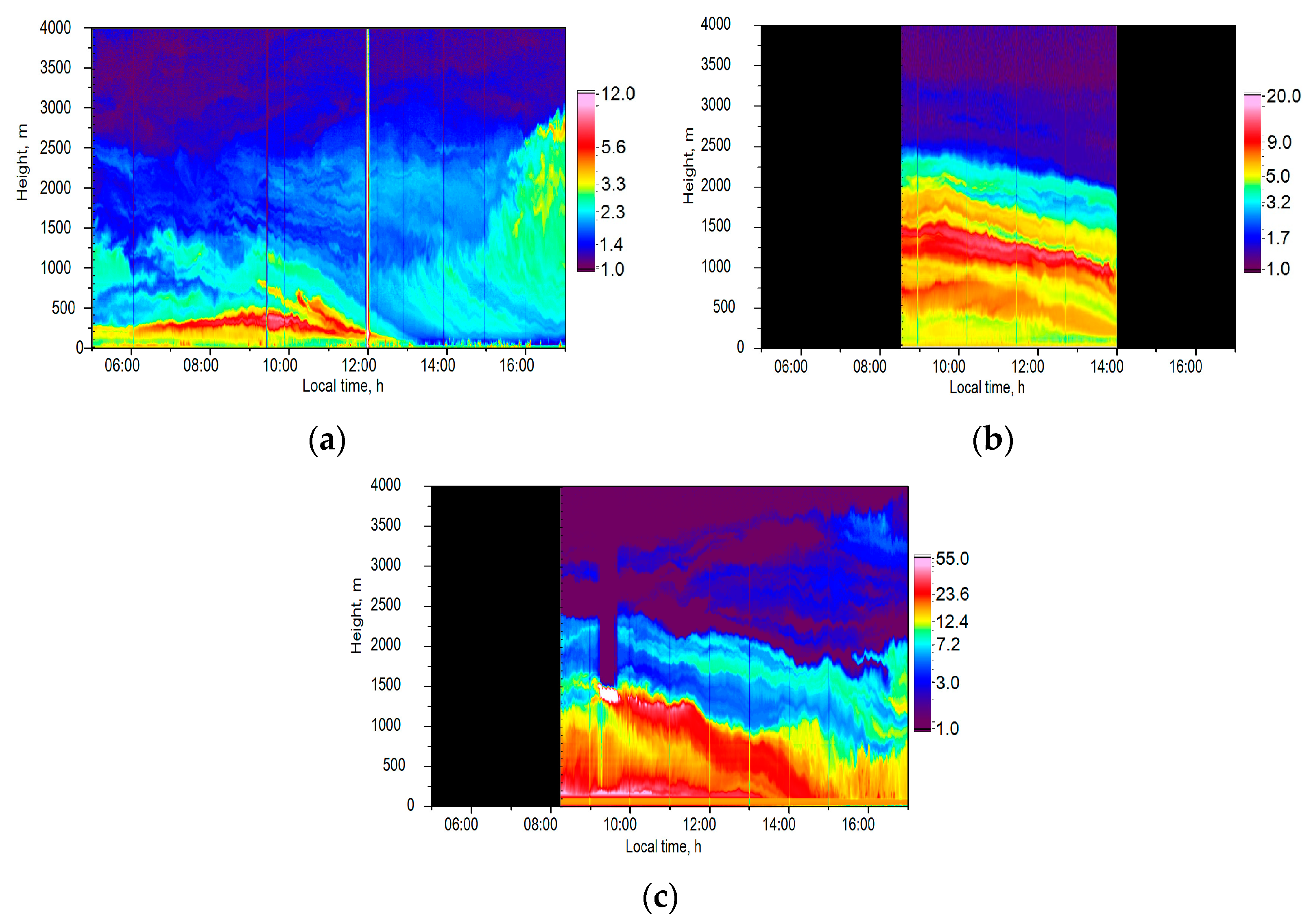
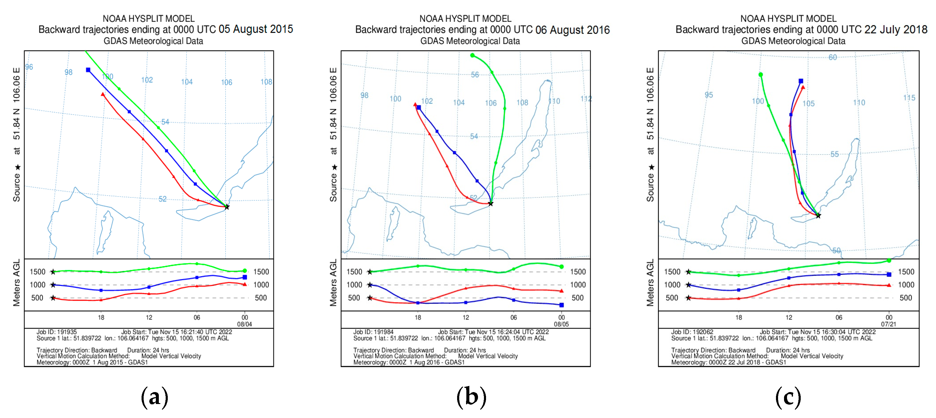
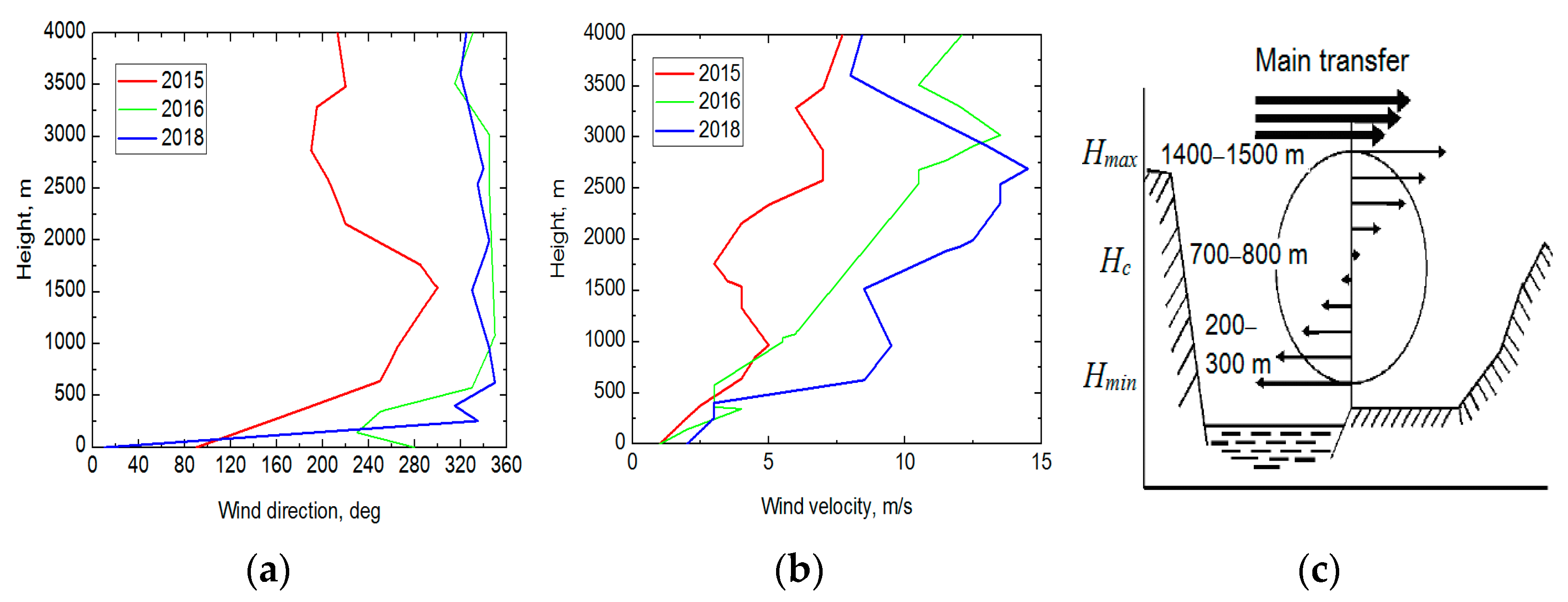
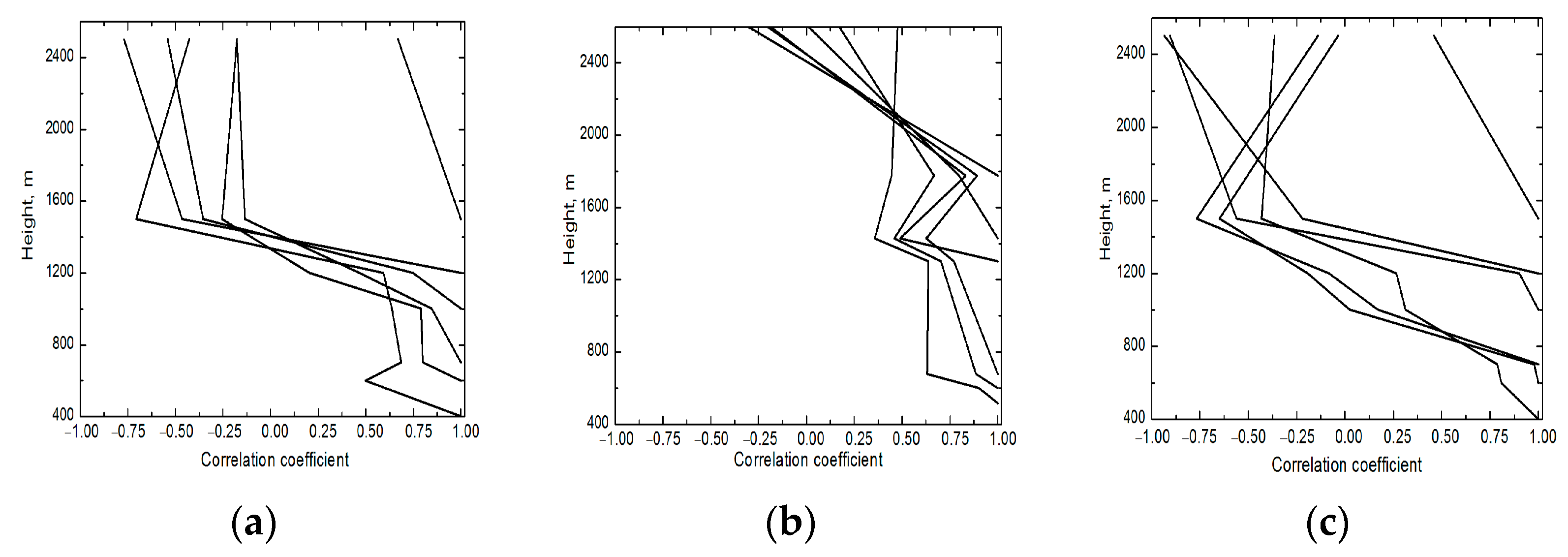
3. Results and Discussion

All statistical characteristics provided in this work were calculated on the basis of experimental data obtained during summer expeditions from 2015 to 2021. Regular lidar observations at the Boyarsky station have shown that the vertical distribution of aerosol fields in the lower troposphere over Baikal in the summer is often a stable structure consisting of several aerosol layers ranging from tens to hundreds of meters in thickness. This pattern was observed in every expedition. Figure 2 shows several examples of vertical sections of the aerosol field in the troposphere obtained with the LOSA-M2 lidar on 5 August 2015, 6 August 2016, and 22 July 2018 from 5:00 to 17:00 LT. The most dynamic processes occur during this period, when the air and the Earth’s surface are gradually heated after sunrise, allowing one to determine the formation of aerosol fields.
The color scale on the right side of the figures corresponds to the magnitude of the backscattering signals corrected to the squared distance at the radiation wavelength λ = 1064 nm, at which the aerosol component of the atmosphere shows the greatest contrast (black color corresponds to time periods without measurements). A common feature of all the fragments in Figure 2 is the clearly distinguishable layers of atmospheric aerosol with different concentrations in the ~4 km altitude range. The two most contrasting layers are seen at altitudes of 200–500 m and 1000–1500 m; they correspond to the boundaries of the inner and the main mixing layers. During the day, the upper layers gradually spread, which leads to the accumulation of aerosol in the lower levels. The filling of the atmosphere progresses upwards and downwards from the both layers. Then, with the weakening of turbulent exchange, the stratification becomes smoother, and aerosol filling occurs more uniformly. On 22 July 2018, a heavy fog occurred in the morning (Figure 2c).
The analysis of high-altitude synoptic maps based on the data of the Arctic and Antarctic Research Institute [11] showed the presence of cyclones over the Baikal region on the days before 5 August 2015 and 22 July 2018, and warm front zones had emerged by the time of the observations. On the days before the observations, there was light rain and low cloudiness. Then, at night, the situation improved, the air cleared up, and the multilayer structures shown in Figure 1a,c formed early in the morning. On 6 August 2016, the weather was determined at the periphery of the high Asian anticyclone, and the surface air layer was within a weak-gradient high-pressure field, which resulted in the stably stratified aerosol structure observed in the atmospheric boundary layer throughout the day (see Figure 2b).
The trajectory analysis, carried out with the use of the HYSPLIT model [12], shows (Figure 3) that the air masses were transported from the northwest. The last part of these trajectories passed over the water area of the lake. Due to the large volume of water, the lake surface temperature changes slightly during the day and thus weakly affects the lower part of the atmospheric boundary layer.
Let us consider the weather conditions under which the above spatiotemporal structures of aerosol fields formed. For this purpose, we used data on altitude variations in the meteorological parameters from the database of the University of Wyoming [13]. The closest point to the measurement site is located in Ust-Barguzin, on the eastern side of the lake (260 km). We also analyzed data from a weather station located in the territory of the Boyarsky station at a 20 m mast. Figure 4 and Figure 5 show the vertical profiles of meteorological parameters for the three cases under study.
The observations made on 5 August 2015 and 22 July 2018 were affected by the temperature inversion at an altitude of ~500 m, which prevented the aerosol in this layer from rising higher. The relative air humidity decreased with altitude and spiked at the boundaries of the main aerosol layers.
Let us consider the altitude variations in the wind speed and direction (Figure 5a,b). The curves show significant fluctuations in the air layer up to 4 km. According to the observations made in 2015 and 2018, two peaks are seen at altitudes of 1000 and 2750 m, and a minimum is seen at 1500–1750 m. The wind speed varies from 1 m/s in the surface air layer to 8–10 m/s at an altitude of 4 km. The wind direction changes significantly with altitude. The largest shift in the wind direction is observed in the lower 600 m layer, and a less significant shift can be seen above 1500 m (in the case of 5 August 2015).
A decrease in the air pressure and an increase in the air temperature were recorded at the weather station. The wind speed was 2–4 m/s at an altitude of 20 m. The wind direction changed from southwest to northwest in a clockwise direction during the observation period (the wind was mainly from the side of the lake).
The behavior of the vertical distribution of the wind speed and direction was described in [14], a study in which cells of the internal basin’s air circulation were found in the atmospheric boundary layer based on the data of aircraft measurements over Baikal and balloon probe measurements taken directly at the Boyarsky station. Such a cell for the eastern coast is schematically shown in Figure 5c. The thin arrows show the wind velocity inside the circulation cell perpendicular to the coastline, and the thick arrows show the main transfer direction. According to our measurements, the lower boundary of this cell is at the altitude Hmin = 200–300 m, and the upper boundary is at Hmax = 1400–1500 m. The center of the cell, where the wind speed is minimal, is at the altitude Hc = 700–800 m. According to the data from Figure 4, this cell is large.
To quantify the relationship between aerosol layers at different altitudes, autocorrelation matrices [15] were calculated for the altitude range of 400–2500 m (Figure 6).
The elements of the autocorrelation matrix are calculated as follows:
r x i x j = ( x i x i ¯ ) ( x j x j ¯ ) ( x i x i ¯ ) 2 ( x j x j ¯ ) 2
according to which we characterized the correlation between the processed lidar signals at two altitude levels, xi and xj. One vertical profile was obtained via averaging over 1 h. The values of the elements of the autocorrelation matrices were calculated at nine fixed heights: 0.4 km, 0.5 km, 0.6 km, 0.7 km, 1 km, 1.2 km, 1.5 km, 1.7 km, and 2.5 km, corresponding to the positions of the lower and upper boundaries of the observed atmospheric aerosol heterogeneities.
As can be seen from Figure 6, close correlations were observed up to altitudes of ~1000 m (the correlation coefficient r ≥ 0.5) on 5 August 2015 and 6 August 2016 (Figure 6a,c). This indicates a single mechanism of formation of aerosol layers in this altitude range. A negative correlation already prevails at an altitude of more than 1400 m (the correlation coefficient r ≥ –0.5). This confirms the hypothesis that the stratified distribution of atmospheric aerosol forms under the action of a wind circulation cell within a cyclone. Under atmospheric conditions of stable anticyclone stratification, a positive correlation between aerosol layers with a high correlation coefficient (≤2500 m) is observed up to the top boundary of the boundary atmospheric layer.

4. Conclusions

Studies of climate change require reliable data on the spatial distribution and optical and physical properties of atmospheric aerosol. Aerosol is one of the main radioactive components of the atmosphere and largely determines its optical properties. The formation of the vertical structure of aerosol fields occurs under the influence of many physical processes.
Through lidar measurements, it was first established that the vertical structure of the atmospheric aerosol fields in the Lake Baikal basin appears as one of separate, stable layers, with a vertical extent of tens to hundreds of meters, as in the case of a stably stratified atmosphere. Through the effect of internal basin air circulation, impurities in the Baikal atmosphere are stratified in height and are transported along the coastline for many tens of kilometers. This is due to the orographic features of the surrounding mountainous terrain. As a result of the analysis, it was found that the general pattern of the calculated autocorrelation matrices shows a good correlation in the range of 0–1000 m (the correlation coefficient is greater than 0.5). The aerosol layers in the lower-kilometer layer are closely related to each other and have a common origin.
The prediction of the propagation of aerosol fields over mountain basins is a complex problem which requires real-time data on many input parameters (the presence of temperature inversions in the atmosphere, relief, wind direction and speed, etc.). The lidar information will allow for the prediction of changes in the vertical profiles of optical parameters of the atmosphere at different points of Baikal through, for example, the use of optimal extrapolation and more accurate estimations of the state of the atmosphere over this natural object, which is important for our planet.

Author Contributions

S.N.: investigation, formal analysis, writing—original draft; Y.B.: conceptualization, methodology, writing—reviewing and editing; M.K.: investigation, formal analysis; G.K.: methodology, investigation, formal analysis; M.N.: software, validation, data curation; I.P.: methodology, investigation, formal analysis. All authors have read and agreed to the published version of the manuscript.

Funding

The analysis of long-term lidar data and the calculation of statistical characteristics were supported by the Russian Science Foundation project no. 22-77-10043, https://rscf.ru/en/project/22-77-10043/, accessed on 1 March 2023.

Institutional Review Board Statement

Not applicable.

Informed Consent Statement

Not applicable.

Data Availability Statement

Images of the spatial sections of the atmospheric aerosol fields of Lake Baikal obtained during the annual lidar expeditions and meteorological data obtained during the observations can be seen on the website of the Institute of Atmospheric Optics, Siberian Branch, Russian Academy of Sciences (http://loza.iao.ru/Data/baikal/, accessed on 20 February 2023).

Conflicts of Interest

The authors declare no conflict of interest.

References

  1. UNESCO World Heritage Convention. Available online: https://whc.unesco.org/ru/list/754 (accessed on 17 February 2023).
  2. Banakh, V.A.; Smalikho, I.N. Lidar observations of atmospheric internal waves in the boundary layer of the atmosphere on the coast of Lake Baikal. Atmos. Meas. Tech. 2016, 9, 5239–5248. [Google Scholar] [CrossRef]
  3. Banakh, V.A.; Smalikho, I.N.; Falits, A.V. Wind-temperature regime and wind turbulence in a stable boundary layer of the atmosphere: Case study. Remote Sens. 2020, 12, 955. [Google Scholar] [CrossRef]
  4. Zayakhanov, A.S.; Zhamsueva, G.S.; Sungrapova, I.P.; Tsydypov, V.V. Features of diurnal variability of ultrafine aerosol in the air of the Baikal coastal zone and arid zone of Mongolia. Atmos. Ocean. Opt. 2018, 31, 257–262. [Google Scholar] [CrossRef]
  5. Golobokova, L.P.; Khodzher, T.V.; Obolkin, V.A.; Potemkin, V.L.; Khuriganova, O.I.; Onischuk, N.A. Aerosol in the atmosphere of the Baikal region: History and contemporary researches. Limnol. Freshw. Biol. 2018, 1, 49–57. [Google Scholar] [CrossRef]
  6. Khodzher, T.V.; Zhamsueva, G.S.; Zayakhanov, A.S.; Dement’eva, A.L.; Tsydypov, V.V.; Balin, Y.S.; Penner, I.E.; Kokhanenko, G.P.; Nasonov, S.V.; Klemasheva, M.G.; et al. Ship-Based Studies of Aerosol-Gas Admixtures over Lake Baikal Basin in Summer 2018. Atmos. Ocean. Opt. 2019, 32, 434–441. [Google Scholar] [CrossRef]
  7. Popovicheva, O.; Molozhnikova, E.; Nasonov, S.; Potemkin, V.; Penner, I.; Klemasheva, M.; Marinaite, I.; Golobokova, L.; Vratolis, S.; Eleftheriadis, K.; et al. Industrial and wildfire aerosol pollution over world heritage Lake Baikal. J. Environ. Sci. 2021, 107, 49–64. [Google Scholar] [CrossRef] [PubMed]
  8. Balin, Y.S.; Bairashin, G.S.; Kokhanenko, G.P.; Penner, I.E.; Samoilova, S.V. LOSA-M2 aerosol Raman lidar. Quantum Electron. 2011, 41, 945–949. [Google Scholar] [CrossRef]
  9. Plakhina, I.N.; Makhotkina, E.L.; Pankratova, N.V. Variations in the atmospheric aerosol optical depth from the data obtained at the Russian actinometric network in 1976–2006. Izv. Atmos. Ocean. Phys. 2009, 45, 456–466. [Google Scholar] [CrossRef]
  10. Tashchilin, M.A.; Yakovleva, I.P.; Sakerin, S.M. Spatio-temporal variations of the aerosol optical depth in the Baikal region. Sovr. Probl. DZZ Kosm. 2021, 18, 219–226. (In Russian) [Google Scholar] [CrossRef]
  11. Arctic and Antarctic Research Institute. Available online: http://old.aari.ru/odata/_d0010.php (accessed on 20 February 2023).
  12. Draxler, R.R.; Rolph, G.D. HYbridSingle-Particle Lagrangian Integrated Trajectory) Model (Dataset). Available online: http://www.arl.noaa.gov/ready/hysplit4.html (accessed on 24 January 2023).
  13. University of Wyoming. Available online: http://weather.uwyo.edu/upperair/sounding.html (accessed on 25 January 2023).
  14. Arshinov, M.Y.; Belan, B.D.; Ivlev, G.A.; Rasskazchikova, T.M. Spatiotemporal characteristics of air circulation in the hollow of Lake Baikal. Atmos. Ocean. Opt. 2001, 14, 263–266. (In Russian) [Google Scholar]
  15. Zuev, V.E. Signals and noise in laser ranging. J. Sov. Laser Res. 1987, 8, 283–426. [Google Scholar] [CrossRef]
Figure 1. Topographic map of the mountainous surroundings of Lake Baikal. The color scale shows height differences in meters above sea level.
Atmosphere 14 00837 g001
Figure 2. Spatiotemporal structure of the atmospheric aerosol field observed with the LOSA-M2 lidar at the Boyarsky station (51.84° N, 106.06° E) on (a) 5 August 2015; (b) 6 August 2016; (c) 22 July 2018. The vertical lines are where the files join.
Atmosphere 14 00837 g002
Figure 3. Back trajectories calculated 24 h before the beginning of the observations at altitudes of 500, 1000, and 1500 m with the HYSPLIT model (UTC): (a) 5 August 2015; (b) 6 August 2016; (c) 22 July 2018. Red line—height 500 m; blue line—height 1000 m; green line—height 1500 m.
Atmosphere 14 00837 g003
Figure 4. Vertical profiles of meteorological parameters according to data from the Ust-Barguzin station: (a) 08:00, 5 August 2015; (b) 08:00, 6 August 2016; (c) 8:00, 22 July 2018.
Atmosphere 14 00837 g004
Figure 5. Vertical profiles of (a) wind direction and (b) wind speed according to the measurements in Ust-Barguzin. (c) Wind circulation cell model from [14].
Atmosphere 14 00837 g005
Figure 6. Vertical profiles of the autocorrelation matrices: (a) 5 August 2015; (b) 6 August 2016; (c) 22 July 2018.
Atmosphere 14 00837 g006
Disclaimer/Publisher’s Note: The statements, opinions and data contained in all publications are solely those of the individual author(s) and contributor(s) and not of MDPI and/or the editor(s). MDPI and/or the editor(s) disclaim responsibility for any injury to people or property resulting from any ideas, methods, instructions or products referred to in the content.

