Article

A Community-Based Sensor Network for Monitoring the Air Quality in Urban Romania

1
Department of Humanities, Ca’ Foscari University of Venice, 3246 Venice, Italy
2
Department of Physics, Faculty of Science, University of Craiova, 200585 Craiova, Romania
3
National Meteorological Administration, 013686 București, Romania
4
Department of Physics and Astronomy, Georgia Southern University, Statesboro, GA 30460, USA
5
Department of Management, Marketing, and Business Administration, Faculty of Economics and Business Administration, University of Craiova, 200585 Craiova, Romania
6
Magnasci SRL, 307160 Timișoara, Romania
*
Author to whom correspondence should be addressed.
Atmosphere 2023, 14(5), 840; https://doi.org/10.3390/atmos14050840
Submission received: 27 March 2023 / Revised: 2 May 2023 / Accepted: 4 May 2023 / Published: 8 May 2023
(This article belongs to the Special Issue PM Sensors for the Measurement of Air Quality)

Abstract

:
Air quality, especially particulate matter pollution levels in urban areas, is an essential academic and social topic due to its association with health issues and climate change. In Romania, increasing awareness of urban communities and the availability of low-cost sensors has led to the development of an independent monitoring network currently distributed in over 194 cities and towns. The uRADMonitor® network consists of 630 sensors measuring PM10 and PM2.5 concentration levels. The spatial distribution of the sensors complements the national air quality network with sensors in residential areas, intense traffic zones, and industrial areas. The data are available through a user-friendly web-based platform from uRADMonitor®. Based on data collected in 2021, we present an analysis of PM10 pollution levels in Romania’s five most populated urban areas by employing five annual statistical indicators recommended by the European Environmental Agency. For the case of Timișoara, we also compare the data measured by independent sensors with those from the national monitoring network. The results highlight the usefulness of our community-based network as it complements the national one.

1. Introduction

Air pollution indiscriminately affects human health at multiple levels everywhere on this planet. It aggravates lung cancers [1], cardiovascular disorders [2], and eye diseases [3]. It triggers asthma attacks and the onset of allergies [4]. It enhances the risk of various respiratory infections [5,6], brain cancers [7], and even neurodegenerative disorders [8]. According to the World Health Organization (WHO), “… almost all of the global population (99%) breathe air that exceeds WHO guideline limits and contains high levels of pollutants, with low- and middle-income countries suffering from the highest exposures” [9]. Vohra et al. estimated that more than 10.4 million people died worldwide in 2012 due to air pollution [10].
As a result, numerous citizen initiatives [11,12,13] have been started worldwide. Despite the uncertainties or limitations associated with low-cost sensors, they aim to monitor air quality using low-cost sensor networks independent from governmental or government-contracted networks [14].
The chief advantages of these networks are that their sensors can be placed in any selected area, thus providing customized coverage of urban regions, highly industrialized areas, or nature reserves, unlike official stations. Moreover, these networks automatically collect data and can triangulate the location of air pollution sources, thus facilitating identification and investigation. Van Brussel and Huyse [15] identified the role of citizen initiatives in air quality monitoring as essential triggers of political and social change in specific communities. Analyzing data collected through civilian sensor networks could lead to environmentally crucial changes in legislation or public initiatives that might diffuse over time to cover a broader region. Additionally, citizens’ involvement might raise awareness of pollution sources initially perceived as unrelated and independent of their community. One major disadvantage of these initiatives is that every time data disagree with official reports, distrust and confusion arise, hopefully prompting investigations and solutions to the problem.
Among many air pollutants, particulate matter (PM) is a significant proxy indicator for air pollution. It is classified based on size: PM10 accounts for coarse particles of less than 10 microns, PM2.5 accounts for small particles of less than 2.5 microns, and PM1 accounts for fine particles of 1 micron or less. To reduce the effects of air pollution on human health, the WHO decreased the alert thresholds in 2021 [16]. Though the PM1 concentration received no special attention, the WHO lowered the concentration limits for PM2.5 and PM10 (over 24 h of exposure) to 15 µg/m3 and 45 µg/m3, respectively. Additionally, more than 3 or 4 exceedances per year are not recommended. Numerous studies allowed for PM10 prediction that attracted special legislative and scientific attention in many countries [17]. As a compounded effect, high variations in seasonal and annual temperatures increase mortality in patients with chronic diseases [18,19,20]. When air pollution limits are exceeded, local authorities could issue alerts to inform vulnerable populations (e.g., elderly, children, and patients) and warn them how to seek protection [21]. Other meteorological factors such as solar radiation, dewpoint temperature, precipitation, cloud pattern, and ambient temperature affect the spatial distribution pattern of PM10 [22], and wind speed affects the long-range horizontal transport, dispersion, and re-suspension of particulate matter [16].
The European Union (EU) policies regarding the air quality standards are executed at the member state level following their national strategies, including strategies for the emission reduction of five key air pollutants: nitrogen oxides, sulfur dioxide, non-methane volatile organic compounds, ammonia, and PM1 [23]. As an EU member, Romania is subject to EU regulations and standards, and it has to comply with them. However, implementing and enforcing these regulations in Romania have presented challenges because the country still struggles with environmental issues. One such major issue is illegal logging, which contributes to deforestation and habitat loss. Furthermore, the country faces air and water pollution and waste management challenges.
In recent years, the Romanian government has taken steps to address these issues and improve environmental regulation and enforcement. The country has developed a National Environmental Strategy and Action Plan outlining measures to address environmental challenges and has established the National Environmental Guard to enforce environmental regulations. However, while Romania has made progress in addressing environmental issues, there is still work to ensure that the country fully complies with the EU’s environmental regulations and protects its natural resources and public health.
One community-based Romanian air quality network is uRADMonitor®, which started due to citizens’ interest in air quality monitoring in their communities. However, many other reasons may be identified [24]. The uRADMonitor® data are meant to benchmark and complement the national network by enabling the monitoring of additional locations. Additionally, uRADMonitor® allows any individual to grow the network by adding more air quality sensors in places of interest linked to the network. Such convenience convinced local authorities in various cities to join this initiative. Furthermore, the availability of affordable sensors, technical support, and a well-established network infrastructure created opportunities for educational investigations and actions to raise awareness regarding air quality and environmental issues among high school and university students.
This work introduces uRADMonitor®, the first non-governmental air quality monitoring network in Romania, which covers over 194 urban areas and provides open access to real-time data. Historical data are also available on request. To present the usefulness and the importance of this network, we used the uRADMonitor® data to investigate the PM10 pollution levels in 2021 in the country’s five most populated cities: București (Bucharest), Constanța, Cluj-Napoca, Iași, and Timișoara. In addition, our study pinpointed two atmospheric pollution episodes in Timișoara that were not reported by the official monitoring network, thus highlighting the importance of such independent networks.

2. Overview of Community-Based Networks on Air Quality Monitoring

The development of low-cost sensors has enabled the spread of independent networks for air quality monitoring, with coverage extending from the local to the global level. The measured air quality parameters vary depending on the specific characteristics of each network, but particulate matter (PM10 and PM2.5) concentrations are usually among the parameters of interest. This section briefly compares our sensors with several community-driven sensor networks that promote transparency and accountability in environmental monitoring, such as the Community Air Sensor Network (CAIRSENSE) [25], the Smart Citizen® network [26], the Public Laboratory for Open Technology and Science, the Public Lab network [27,28], the Eye on Earth initiative [29], the Global Learning and Observations to Benefit the Environment (GLOBE) [30], the HabitatMap© [31], the Imperial County Community Air Monitoring Project [32,33], and the Citizen Weather Observer Program (CWOP) [34] (Section S1). While our list is not exhaustive, it aims to highlight citizens’ interest in ambient air quality, a context with which the uRADMonitor® network is fully aligned. Other initiatives and studies have also documented using low-cost sensors to monitor particulate matter finer than PM10 and PM2.5 [35,36].
In addition to its mission of developing innovative technologies that positively impact our community, thus aligning with many of the above-listed networks, uRADMonitor® has an essential educational component: this network’s main plus. MagnaSCI produces educational sensors kits and supports educational initiatives that help students learn new technologies and involve them in making, programming, and connecting our sensors to the network. Additionally, MagnaSCI manufactures sensors for environmental radiation monitoring. However, one disadvantage comes from having many sensors installed in high schools rather than having these sensors uniformly spread out for a thorough territory coverage. Furthermore, many of these sensors go offline because of a lack of ongoing maintenance due to frequent WiFi or power failures, thus affecting data collection continuity. Additionally, these sensors would better serve the community if installed in rural or industrial areas rather than the city’s least polluted places.

3. uRADMonitor® Network Features

3.1. Background

The uRADMonitor® project was started in 2014 by implementing a radiation monitoring network in Timișoara. In 2016, the first mobile solution for investigating air quality was deployed in Cluj-Napoca in partnership with Orange Romania by deploying uRADMonitor® on city buses [37]. We then expanded this air quality network by installing about 100 more sensors in other cities: Alba Iulia, Iași, București, and Timișoara. The uRADMonitor® network and its sensors have received several awards at the Regional Innovation Fair, Romania, 2015; the Innovation Labs, Romania, 2016; the PatriotFest, Romania, 2018; and the AIRLAB Microsensors Challenge, France, 2021.
In recent years, due to the robustness of the uRADMonitor® sensors, an increasing number of local authorities (e.g., Vrancea County Council, Bistrita municipality, and Brasov City Hall) joined the air monitoring network. In addition, two volunteering projects sponsored by the OMV Petrom multinational company and implemented by the Faculty of Science at the University of Craiova in partnership with the local network of high schools contributed to the growth of the network in the Oltenia region [38].
By 2018, the air quality monitoring network had also internationally expanded through cooperation with other institutions: VTT Technical Research Centre (Finland), University of Evora (Portugal), NPL Management Ltd. (UK), Vinca Institute of Nuclear Sciences (Serbia), Institute for Astronomy of the University of Hawaii (USA), George Washington University (USA), West Texas A&M University (USA), RMIT University ECE (Australia), The Synergy Group (Chile), and others.
Currently, the air quality monitoring network is present in 941 cities in 66 countries; in Romania, we have installed 630 operational sensors measuring PM10 and PM2.5 in over 194 cities.

3.2. Sensors Distribution

The voluntary participation of individuals and local authorities in the network is crucial to its success and growth. One can notice this strategy reflected in the spatial distribution of sensors across the city. For example, volunteers have installed the sensors around private residences, public institution buildings, or commercial properties in different locations (e.g., front yard, backyard, balcony, porch, and façade). Sometimes, volunteers have placed these sensors at sites of higher interest, e.g., where many locals noticed air quality issues after closing volunteering agreements with residents or institutions. Consequently, the sensors do not regularly cover urban spaces.
Furthermore, the vertical placement of the sensors is not uniform. One may position a sensor at any height ranging from 1 m to 30 m above the ground, which corresponds with the lower and upper floors of most buildings in Romania. A sensor’s vertical location variation may impact measurement consistency at different scales (e.g., city vs. district), as many studies have demonstrated an altitude dependence of particulate matter concentration [39,40]. However, given the relatively low range of height variation in regions with low pollution, the impact of different sensor heights in data analysis is expected to be low [41,42,43,44]. Additionally, measurements are relevant at an individual scale, as they provide real-time information on air quality at heights and places where people usually spend time (e.g., homes, gardens, and school courtyards)

3.3. Technical Characteristics of Our Sensors

Our study used SMOGGIE-PM and A3, two sensors manufactured by Magnasci SRL, Timișoara, Romania [45]. The National Research and Development Institute for Industrial Ecology, Romania, tested A3 for accuracy. In contrast, the Air Quality Sensor Performance Evaluation Center, USA, and the Observatoire de la qualité de l’air en Île-de-France, France, tested both the A3 and SMOGGIE sensors. Since Qin et al. demonstrated the improved performance of fixed sensors compared with mobile ones [46], we only used fixed sensors in our study.
SMOGGIE-PM and A3 measure meteorological parameters such as air temperature (0.5 °C resolution and ±1 °C accuracy), barometric pressure (±0.25% accuracy), and relative humidity (1% resolution and ±2% accuracy). They also use an integrated laser scattering detector (Figure 1) to measure PM1, PM2.5, and PM10 concentrations in the air (1 µg/m3 resolution, ±5% accuracy, and R2 = 0.99 coefficient of correlation to reference gravimetric sampler) [45].
A pulse of coherent infrared light shines through a cavity with a PIN photodiode located sideways to detect PM concentrations. The fan forces air into the chamber. As a particle reaches the laser beam, it scatters the laser light, and the photodiode detects the scattered light. The amplitude of the recorded scattered signal is proportional to the particle size. We can then correlate the number of events to the mass concentration.
In addition, A3 can track volatile organic compounds (±5% accuracy) using a metal-oxide sensor. Furthermore, A3 can detect formaldehyde (10 ppb resolution and ±5% accuracy) and ozone (10 ppb resolution and ±5% accuracy) using two different electrochemical sensors, carbon dioxide (1 ppm resolution and ±5% accuracy) using a non-dispersive infrared sensor, and noise level (1 dB resolution and ±10% accuracy) based on an analogic sensor. A fan provides an air stream over the sensing components.

3.4. Client–Server Architecture

The system stretches from many compact hardware detectors capable of sensing the environment via electronic sensors to big data software solutions that can handle vast amounts of data in real time. With the network spreading quickly, periodic upgrades on the server side are a must to provide a high-quality, uninterrupted service.
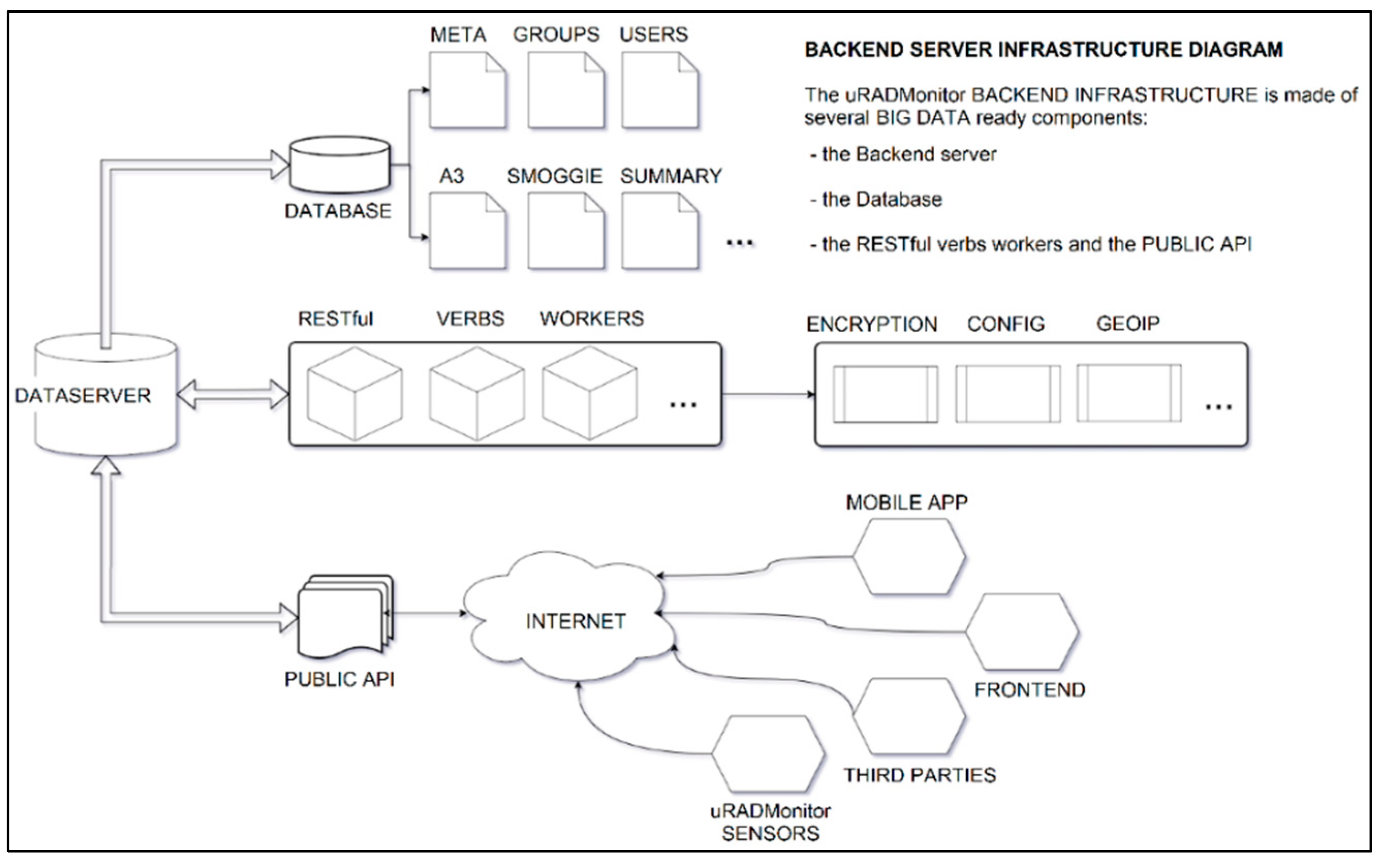
The backend is a separate server in charge of the system database and the uRADMonitor® RESTful APIs (i.e., the interfaces two computers use to securely exchange information over the internet). It aims to provide input/output real-time data operations via a mature API (i.e., application programming interface). It receives data from the distributed detectors and provides data to the front end, mobile apps, and other parties via API calls (see Figure 2). A big-data-ready database stores the data.

3.5. Data Upload

Data is automatically collected with a temporal sampling of one minute. One can configure the interval in firmware or via USB terminal commands to cope with the deployment purpose (e.g., mobile units need faster sampling and remote units operating on lower power or limited bandwidth (or both) need a reduced sampling rate). The sensors connect to the internet via several connectivity means. Depending on device type, these include cable links via Ethernet or radio links including GSM, WiFi, LoRaWAN, Helium, and Bluetooth Low Energy. In addition, users can remotely access recorded data via the uRADMonitor® API, or the recorded data can be decentralized on users’ local networks.

3.6. Data Access

The uRADMonitor® network comprises hundreds of interconnected devices for automated and continuous environmental monitoring. Each device contributes unique ecological data to help illustrate the pollution levels at a large scale. Each contribution is valuable and builds the system as a whole. However, centralized topology is not the best answer in certain situations, so more flexibility is required. For privacy reasons, each sensor must be used in a local network without involving the uRADMonitor® server and API (no external internet links). The user policy prohibits data export or external links for security reasons, so all devices are part of a closed loop. In the case of force majeure, the central uRADMonitor® DATA server is down or out of use.
Therefore, decentralized use is also supported to ensure the data flow’s survival and proper operation. We designed systems with several easy ways to access the data:
(a)
All recent devices have a micro-USB connector that can power the unit (5V), configure and debug the device, or access the data. We can locally access the data by connecting the unit via USB, opening a serial terminal at a band rate of 9600 bps, and (once associated) typing the “get data” command (see Figure S1 in the Supplementary Materials document).
(b)
Local access via the unit’s local network IP for those devices with WiFi or Ethernet connectivity. If the devices connect through GSM or LoRaWAN, one cannot access them via an IP address. Instead, one can use a browser to access a built-in mini web server to see the data saved as a .json file.
(c)
Web access via the uRADMonitor® portal frontend by opening the link http://www.uradmonitor.com/?open=ID (accessed on 22 March 2023), where ID is the device ID. This approach opens the global map on the unit-preconfigured location, plotting the sensor data on the charts.
(d)
Using the uRADMonitor® cloud API, via REST API calls, following the details presented in the API manual [47].
(e)
As datasets via the uRADMonitor® Dashboard [48] (see Figure S2).
(f)
Via the uRADMonitor® mobile app for Android smartphones (see Figure S3).
Out of these multiple options, of particular interest is API access. The REST API does not require the client to be familiar with the API’s structure. Instead, the server delivers whatever information the client needs. The API is used for both directions of data transfer (upload and download). Additionally, sensors upload their readings through the API to the server. The server processes the data before storing it in the database. The front end, the mobile app, or third-party systems using the data given by uRADMonitor® can access data using the API [47].
The network server stores the data for an indefinite period. However, the API calls allow data history exports in two-month intervals regardless of the selected time window. Open access to recorded data lets users view them in real-time or for a pre-configured interval. The datasets include geolocation parameters and time stamps for all readings (i.e., air quality-related and meteorological data). The users managing one or more sensors in the network may download the data from the web in the .csv or .json formats for time intervals ranging from one day to two months. One may download the data as a file or program the existing API to simultaneously download the data on multiple sensors. Upon request to the network administrator, data can be downloaded as archives of more than two months or at an averaging scale (e.g., hourly and daily), as requested by the user using MySQL-based scripts that directly access the database. This flexibility is beneficial for custom research works where the researcher must select a data output format to match the project needs and save any additional post-processing work.

4. Materials and Methods

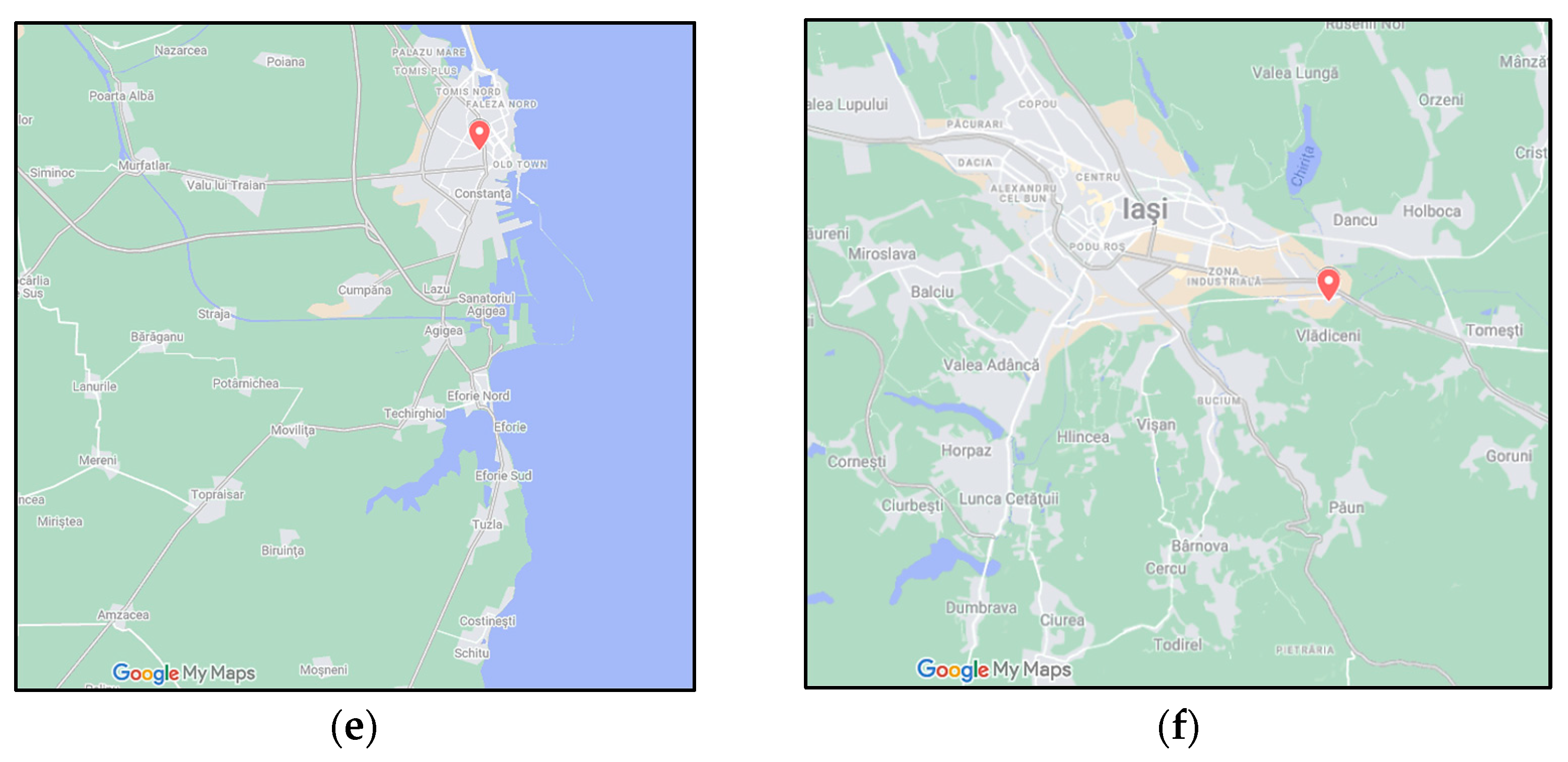
When analyzing the data provided by the uRADMonitor® network, we considered recordings from January 2021 to December 2021 from seven sensors (Table 1) located in Romania’s five most populated cities (see Figure 3a). In addition, we investigated the relationship between PM10 concentrations and local weather parameters such as temperature, humidity, and atmospheric pressure. In this study, we employed two datasets, one recorded by the uRADMonitor® sensors and the second acquired from the official network of the National Agency for the Environment for Timișoara [49]. The sensors from București, Timișoara, Cluj-Napoca, and Constanța are in residential areas (see Figure 3b–e). In contrast, the sensor in Iași is in an industrial area (see Figure 3f).
The official monitoring network includes 148 automatic air quality monitoring stations, 11 mobile stations distributed at the country level (30 traffic, 58 industrial, 37 urban background, 13 suburban locations, 7 regional locations, and 3 EMEP types), and 37 stations for environmental radioactivity monitoring [50]. In Timișoara, four monitoring stations cover the main aspects of urban pollution sources: industrial, urban traffic, and urban background. We compared the TM2 urban background monitoring station’s data with those from our nearby uRADMonitor® sensors. Figure 4 shows the geolocation of these sensors in Timișoara. The TM2 data included gravimetric (GRAV) and optical/nephelometric (LPSM) measurements. The GRAV is a chemical method that quantifies the amount of PM in air based on the weight difference (pre- and post-sampling) absorbed by a filter. The gravimetric method is the most used technique to measure PM concentrations following international guidelines.
In contrast, LPSM is a technique that measures turbidity or cloudiness in a solution with particles using a light scattering method to quantify the number of insoluble particles in a sample. The data from the national monitoring station consist of 326 daily values for GRAV measurements and 340 daily values for the LPSM measurement method. In comparison, TIM-235 has logged 309 daily values, and CTA has logged 361 daily values.
Our analysis was focused on the investigation of five PM10 indicators, as defined by EEA directives [51]: (a) the annual mean (P1Y) [52], (b) the daily limit value (DLV) or the daily maximum (P1Y-day-max) [53], (c) the 50th percentile of daily values in a given year (P1Y-day-per50) [54], (d) the 90.4th percentile of daily averages in a given year (P1Y-P1D-per90.4) [55], and the number of days exceeding this threshold value. The Ambient Air Quality Directive (AAQD) requires using the 90.4 percentile indicator when making random measurements to assess the DLV [51]. In addition, the AAQD describes the PM10 DLV as a daily average of 50 μg/m3 not to be exceeded more than 35 times per calendar year [56]. Therefore, if the PM10 DLV exceeds the threshold 35 times/year, the rest of that year’s 90.4% of days are below such threshold. These indicators allowed us to compare our data with the Romanian and official EEA reports. In addition, choosing these indicators [51] allowed us to compare the officially reported Romanian data to EEA data later. However, such information was not yet available for 2021.
Furthermore, we investigated the relationship between local meteorological conditions and PM10 concentration levels on a daily scale by using the Pearson correlation coefficient between the two-time series for all selected sensors. For each sensor, the analysis was performed over the entire year, i.e., we included all available PM10 concentration measurements except those days when the sensor was down. Furthermore, a daily mean value of the PM10 concentration was calculated daily. The comparison between uRADMonitor® data and the Agenția Națională pentru Protecția Mediului (ANPM, National Agency for Environmental Protection) data for Timișoara included the analysis of the EEA indicators for these two datasets. As a result, we identified two pollution cases from the uRADMonitor® data analysis.

5. Results

5.1. Analysis Based on EEA Indicators

The annual mean of daily PM10 concentrations showed the highest values in Timișoara (TIM-0C2), followed by Cluj-Napoca and Iași (C-NAP and IASI) (Figure 5). In contrast, we found the lowest values in Timișoara’s city center (TIM-235). For the latter sensor, the results may have been affected by the smaller time series (only 309 daily values), which might not have detected the episodes with the higher PM10 concentrations recorded by the TIM-0C2 sensor. It is worth noting that four out of the seven sensors in Timișoara, București, Cluj Napoca, and Iași indicated annual mean values that were more elevated than the threshold value of 20 µg/m3 recommended by WHO guidelines [57]. In București and Timișoara, however, the other two sensors indicated better air quality levels at an annual scale, with annual means between 7.37 and 18.71 µg/m3. These results emphasize the influence of local factors on PM10 concentration and air quality management in those areas.
The 90.4 and 50 percentile indicators (Figure 6) emphasized a similar situation. The highest values in Timișoara, București, Cluj-Napoca, and Iași supported the previous finding, indicating consistently higher values throughout the year. Interestingly, although we located the sensor in an industrial area of Iași, the values were slightly lower than in the residential areas in Cluj Napoca. Finally, the data from Constanța, the most complete of the used all-time series (361 daily values), indicated the best conditions between the analyzed cities, with consistently low indicators at a yearly scale.
The maximum daily value indicator (Figure 7a) highlighted the highest values in București, Iași, and Timișoara, which were above 100 µg/m3 in all cases. In addition, the indicator showed additional information regarding the number of days with values above 50 µg/m3, for which the WHO recommends a maximum of three or four exceeding events per year. As shown in Figure 7b shows this was only the case for the Timișoara city center and Constanța. For all other sensors, there were more than ten days with above-threshold PM10 daily values, the maximum (51 days) found at Timișoara.

5.2. Correlation between PM10 Concentrations and Meteorological Parameters

We used the Pearson correlation coefficient for the time series to investigate the relationship between PM10 daily values and the local meteorological factors. The results showed that air humidity played a minor role in the accumulation of PM10 levels, as the correlation coefficient was below 0.27. We reached a similar conclusion in a previous study for Craiova using data from five uRADMonitor® sensors [58]. However, it is critical to state that air humidity could significantly impact PM10 concentration at seasonal levels and depends on season type [59,60,61,62] or certain meteorological conditions such as haze [63].
The PM10 concentration was positively correlated with the atmospheric pressure. Still, the correlation intensity varied between cities and even the sensors in the same city, ranging from 0.096 in Constanța to 0.519 in Timișoara (TIM-0C2). This variation was possibly due to the wind effects, which we did not account for. Nevertheless, other studies have confirmed the positive correlation between PM10 and atmospheric pressure [64,65]. They explained that increasing atmospheric pressure impedes the dispersion of particulate matter in space, favoring accumulation, thus leading to higher PM concentrations.
Finally, the correlation between PM10 concentration and the air temperature was negative. Others have reached the same conclusion [36,60,61,65,66]. However, the strength of the correlation varied across the city from −0.107 (TIM-235) to −0.635 (TIM-0C2). Variations in the correlation intensity between PM10 concentrations and meteorological factors have been reported in other studies as well [61], and they can occur on not only a daily scale but also shorter time scales (12 h averages) [66]. Thus, our results may have been affected by the averaging over a yearly time scale, which only allowed us to explicitly focus on periods of the year when PM10 concentration levels are more affected by local meteorological conditions. In addition, other factors, such as the wind speed and direction at the time and location of PM10 measurements, urban spatial characteristics in the vicinity of the sensor location (e.g., height and density of buildings) [67,68,69], and the presence and status of vegetation near the sensor [70], may have also influenced the obtained results.

5.3. Comparison with ANPM Data for Timișoara

We further compared the data from uRADMonitor® independent monitoring network with data from the national monitoring network managed by ANPM. To this end, we extracted PM10 daily data for TM2 urban background station in Timișoara for 2021, and we computed the five EEA indicators selected for both GRAV and LPSM measurement types. Figure 8 shows that the ANPM dataset provided consistently lower indicator values than uRADMonitor® sensors through both measurement methods, but there was a good general agreement between the two datasets. The most evident differences were the number of days with PM10 daily values above 50 µg/m3. Thus, we found a maximum of 9 days in the ANPM data (which used the nephelometric measurement method) and 51 days in the uRADMonitor® data. Additionally, the ANPM data indicated much lower values than our independent TIM-0C2 sensor. These discrepancies translated into a higher daily maximum and a higher 90.4 percentile for our sensor. Still, the difference compared with the ANPM data was lesser (i.e., with a factor of 1.54 for the 90.4 percentile indicator and 1.27 for the maximum daily value compared with a factor of 5.66 for the number of days with concentration levels above the threshold).
One may notice that the independent sensor in the residential area of the city center (TIM-235) showed relatively low values for all EEA indicators compared with the second sensor (TIM-0C2) and the ANPM data. However, as indicated before, this may have been caused by missing data (only 309 daily values in the time series) and the sensor’s location in a pedestrian area (thus without traffic in its vicinity).

5.4. Pollution Episode in Timișoara

We investigated the daily mean values of the PM10 concentrations measured by our TIM-0C2 sensor from 15 February 2021 to 8 March 2021. Despite three days with no recorded data, all others showed PM10 concentrations above the pollution threshold recommended by the EEA. As such, a set of pollution episodes was detected by our TIM-0C2 sensor. An air pollution episode was recorded when the PM10 daily mean values peaked above 50 µg/m3 for at least three consecutive days. We then compared our findings with the ANPM data for the same time interval (Figure 9).
As shown in Table 2, the ANPM data only identified five days with exceeding PM10 daily values compared with 19 days found in the uRADMonitor® data. The differences may have been due, among other factors, to the different locations of the two sensors, with their measurements possibly being affected by local conditions (e.g., wind). Nevertheless, the results highlight the added value of a secondary monitoring network, which may cover more areas than the national network, thus providing more data and better information about the resident population and local authorities.
Comparing the Pearson correlation coefficients for the entire time series of daily values recorded by uRADMonitor and ANPM for Timisoara in 2021 shows that the ANPM’s TM-2 sensor better agreed with our TIM-235 sensor (Table 3). This increased correlation may have been related to the closer proximity of these two sensors, situated less than 500 m apart, compared with the approximate 2 km distance between TIM-0C2 and TM-2.

6. Discussion and Conclusions

The educational aspect is a critical component associated with the uRADMonitor® network and with independent, low-cost sensor networks in general. Regarding the uRADMonitor® network, two volunteering projects [38] have used the network’s facilities in public awareness campaigns involving university and high school students. Furthermore, the network facilities were employed in an international summer school [59] organized at the University of Craiova, Romania. The students from four partner universities learned how a sensor is made using a microcontroller and how to program and connect their sensors to the broader network. Students might choose to analyze and interpret the data given by these networks as a subject of their bachelor’s or master’s thesis. Some high schools and universities “adopted” sensors. Students have shown their parents the real-time values of the pollutant concentrations near their high schools and universities. Their parents have become more attentive when they notice air pollution episodes near their children’s high schools and universities, and they have asked for explanations from the local authorities. As a result, pressure on the authorities has significantly increased. In the long term, this pressure is expected to lead the charge to find solutions for citizens’ benefit and to enable better transparency in the authorities’ communication.
Regarding the data provided by uRADMonitor® independent network, the analysis of measurements for the five most populated cities in Romania showed that Timișoara center, Constanța, and some areas in București had generally low pollution levels in 2021. However, in each city (except for Constanța), at least one sensor exceeded the WHO-recommended annual value. Furthermore, in all cities except Constanța, the number of days exceeding the recommended PM10 levels was higher than the WHO’s recommendation. In addition, a positive correlation between atmospheric pressure and a negative correlation with air temperature was found, in line with the findings of other studies. Still, their intensity varied among sensors and cities. The comparison with ANPM data for Timișoara showed a fair agreement with TIM-0C2 data for all used indices. Nonetheless, the ANPM data did not identify the same/entire pollution episodes, possibly due to missing data.
The study’s limitations reside in several sources, such as the short time interval of the data analysis, the differences in the heights of sensor locations, and the uncertainties associated with the performance of low-cost sensors compared with the standard ones, including different measurement principles. Therefore, a more in-depth analysis of the differences between the uRADMonitor® and ANPM data, extended to more urban areas in Romania, is needed to establish an optimum approach to using the two datasets.
Nevertheless, the results of the data analysis highlight the importance and added value of the independent monitoring network in terms of data availability, coverage, and real-time access to open data. Furthermore, considering the educational component and increasing citizens’ awareness to which these data contributed, the uRADMonitor® has the potential to contribute to the design and application of national and local policies that assure improved air quality.

Supplementary Materials

The following are available online at https://www.mdpi.com/article/10.3390/atmos14050840/s1, Figure S1: Local vs. decentralized data access data via a USB cable on uRADMonitor® sensors, Figure S2: Example of the Dashboard Data download options as .json and .csv file format, Figure S3: uRADMonitor® Mobile App for sensor data visualization, Section S1: Overview of communi-ty-based networks on air quality monitoring, and Section S2: Technical information.

Author Contributions

Conceptualization: L.V.; methodology: M.T.U.; formal analysis: L.V. and M.T.U.; investigation: R.M.; resources: S.P.; data curation: R.M.; writing—original draft preparation: L.V., M.T.U., S.P. and R.M.; writing—review and editing: S.P. and D.A.; visualization: D.A. All authors have read and agreed to the published version of the manuscript.

Funding

This research received no external funding.

Institutional Review Board Statement

Not applicable.

Informed Consent Statement

Not applicable.

Data Availability Statement

The data provided by the uRADMonitor® network used in this study are available upon request from the corresponding author. ANPM data are available from [49].

Acknowledgments

MTU and DA acknowledge the support of the Fulbright program for their research at Georgia Southern University.

Conflicts of Interest

The authors declare no conflict of interest.

References

  1. Xue, Y.; Wang, L.; Zhang, Y.; Zhao, Y.; Liu, Y. Air pollution: A culprit of lung cancer. J. Hazard. Mater. 2022, 434, 128937. [Google Scholar] [CrossRef] [PubMed]
  2. Shahriyari, H.A.; Nikmanesh, Y.; Jalali, S.; Tahery, N.; Zhiani Fard, A.; Hatamzadeh, N.; Zarea, K.; Cheraghi, M.; Mohammadi, M.J. Air pollution and human health risks: Mechanisms and clinical manifestations of cardiovascular and respiratory diseases. Toxin Rev. 2022, 41, 606–617. [Google Scholar] [CrossRef]
  3. Lin, C.-C.; Chiu, C.-C.; Lee, P.-Y.; Chen, K.-J.; He, C.-X.; Hsu, S.-K.; Cheng, K.-C. The Adverse Effects of Air Pollution on the Eye: A Review. Int. J. Environ. Res. Public Health 2022, 19, 1186. [Google Scholar] [CrossRef] [PubMed]
  4. Nanda, A.; Mustafa, S.S.; Castillo, M.; Bernstein, J.A. Air Pollution Effects in Allergies and Asthma. Immunol. Allergy Clin. 2022, 42, 801–815. [Google Scholar] [CrossRef] [PubMed]
  5. Monoson, A.; Schott, E.; Ard, K.; Kilburg-Basnyat, B.; Tighe, R.M.; Pannu, S.; Gowdy, K.M. Air pollution and respiratory infections: The past, present, and future. Toxicol. Sci. 2023, 192, 3–14. [Google Scholar] [CrossRef] [PubMed]
  6. Loaiza-Ceballos, M.C.; Marin-Palma, D.; Zapata, W.; Hernandez, J.C. Viral respiratory infections and air pollutants. Air Qual. Atmos. Health 2022, 15, 105–114. [Google Scholar] [CrossRef]
  7. Nikmanesh, Y.; Mohammadi, M.J.; Yousefi, H.; Mansourimoghadam, S.; Taherian, M. The effect of long-term exposure to toxic air pollutants on the increased risk of malignant brain tumors. Rev. Environ. Health 2022. [Google Scholar] [CrossRef]
  8. Murata, H.; Barnhill, L.M.; Bronstein, J.M. Air Pollution and the Risk of Parkinson’s Disease: A Review. Mov. Disord. 2022, 37, 894–904. [Google Scholar] [CrossRef]
  9. WHO. Air Pollution. Available online: https://www.who.int/health-topics/air-pollution (accessed on 9 March 2023).
  10. Vohra, K.; Vodonos, A.; Schwartz, J.; Marais, E.A.; Sulprizio, M.P.; Mickley, L.J. Global mortality from outdoor fine particle pollution generated by fossil fuel combustion: Results from GEOS-Chem. Environ. Res. 2021, 195, 110754. [Google Scholar] [CrossRef]
  11. Wesseling, J.; de Ruiter, H.; Blokhuis, C.; Drukker, D.; Weijers, E.; Volten, H.; Vonk, J.; Gast, L.; Voogt, M.; Zandveld, P.; et al. Development and Implementation of a Platform for Public Information on Air Quality, Sensor Measurements, and Citizen Science. Atmosphere 2019, 10, 445. [Google Scholar] [CrossRef]
  12. Golumbic, Y.N.; Fishbain, B.; Baram-Tsabari, A. User centered design of a citizen science air-quality monitoring project. Int. J. Sci. Educ. Part B 2019, 9, 195–213. [Google Scholar] [CrossRef]
  13. De Craemer, S.; Vercauteren, J.; Fierens, F.; Lefebvre, W.; Meysman, F.J.R. Using Large-Scale NO2 Data from Citizen Science for Air-Quality Compliance and Policy Support. Environ. Sci. Technol. 2020, 54, 11070–11078. [Google Scholar] [CrossRef] [PubMed]
  14. Diviacco, P.; Iurcev, M.; Carbajales, R.J.; Potleca, N. First Results of the Application of a Citizen Science-Based Mobile Monitoring System to the Study of Household Heating Emissions. Atmosphere 2022, 13, 1689. [Google Scholar] [CrossRef]
  15. Van Brussel, S.; Huyse, H. Citizen science on speed? Realising the triple objective of scientific rigour, policy influence and deep citizen engagement in a large-scale citizen science project on ambient air quality in Antwerp. J. Environ. Plan. Manag. 2019, 62, 534–551. [Google Scholar] [CrossRef]
  16. WHO. Compendium of WHO and Other UN Guidance on Health and Environment. Available online: https://www.who.int/publications/i/item/WHO-HEP-ECH-EHD-22.01 (accessed on 10 March 2023).
  17. Taheri Shahraiyni, H.; Sodoudi, S. Statistical Modeling Approaches for PM10 Prediction in Urban Areas; A Review of 21st-Century Studies. Atmosphere 2016, 7, 15. [Google Scholar] [CrossRef]
  18. Madrigano, J.; Mittleman, M.A.; Baccarelli, A.; Goldberg, R.; Melly, S.; von Klot, S.; Schwartz, J. Temperature, myocardial infarction, and mortality: Effect modification by individual- and area-level characteristics. Epidemiology 2013, 24, 439–446. [Google Scholar] [CrossRef] [PubMed]
  19. Berko, J.; Ingram, D.D.; Saha, S.; Parker, J.D. Deaths attributed to heat, cold, and other weather events in the United States, 2006–2010. Natl. Health Stat. Rep. 2014, 76, 1–15. [Google Scholar]
  20. Velea, L.; Udristioiu, M.T.; Bojariu, R.; Sararu, S.C.; Prunariu, L. The influence of climate conditions on the mortality related to cardiovascular diseases in Dolj county (Southern Romania). AIP Conf. Proc. 2017, 1796, 040003. [Google Scholar] [CrossRef]
  21. United States Environmental Protection Agency. Recommendations and Guidance for EPA to Develop Monitoring Programs in Communities; United States Environmental Protection Agency: Washington, DC, USA, 2017.
  22. Tshehla, C.E.; Wright, C.Y. Spatial and Temporal Variation of PM10 from Industrial Point Sources in a Rural Area in Limpopo, South Africa. Int. J. Environ. Res. Public Health 2019, 16, 3455. [Google Scholar] [CrossRef]
  23. European Environment Agency. Air Polution: Policy Context; European Environment Agency: Copenhagen, Denmark, 2021. [Google Scholar]
  24. Commodore, A.; Wilson, S.; Muhammad, O.; Svendsen, E.; Pearce, J. Community-based participatory research for the study of air pollution: A review of motivations, approaches, and outcomes. Environ. Monit. Assess. 2017, 189, 378. [Google Scholar] [CrossRef]
  25. Jiao, W.; Hagler, G.; Williams, R.; Sharpe, R.; Brown, R.; Garver, D.; Judge, R.; Caudill, M.; Rickard, J.; Davis, M.; et al. Community Air Sensor Network (CAIRSENSE) project: Evaluation of low-cost sensor performance in a suburban environment in the southeastern United States. Atmos. Meas. Tech. 2016, 9, 5281–5292. [Google Scholar] [CrossRef] [PubMed]
  26. Smart Citizen®. Available online: https://smartcitizen.me (accessed on 20 March 2023).
  27. Gibney, E. ‘Open-hardware’ pioneers push for low-cost lab kit. Nature 2016, 531, 147–148. [Google Scholar] [CrossRef] [PubMed]
  28. Public Laboratory for Open Technology and Science. Available online: https://publiclab.org/ (accessed on 20 March 2023).
  29. European Environment Agency: New Eye on Earth Global Mapping and Information Service Now Live. Available online: https://www.eea.europa.eu/media/newsreleases/new-eye-on-earth-global (accessed on 20 March 2023).
  30. Global Learning and Observations to Benefit the Environment (GLOBE) Program. Available online: https://www.globe.gov/ (accessed on 21 March 2023).
  31. HabitatMap©. Available online: https://www.habitatmap.org/ (accessed on 21 March 2023).
  32. Imperial County Community Air Monitoring Project. Available online: https://trackingcalifornia.org/imperial-air-project/imperial-air-project-landing (accessed on 21 March 2023).
  33. English, P.B.; Olmedo, L.; Bejarano, E.; Lugo, H.; Murillo, E.; Seto, E.; Wong, M.; King, G.; Wilkie, A.; Meltzer, D.; et al. The Imperial County Community Air Monitoring Network: A Model for Community-based Environmental Monitoring for Public Health Action. Environ. Health Perspect. 2017, 125, 074501. [Google Scholar] [CrossRef]
  34. Citizen Weather Observer Program. Available online: http://www.wxqa.com/ (accessed on 21 March 2023).
  35. Shah, R.U.; Padilla, L.E.; Peters, D.R.; Dupuy-Todd, M.; Fonseca, E.R.; Ma, G.Q.; Popoola, O.A.M.; Jones, R.L.; Mills, J.; Martin, N.A.; et al. Identifying Patterns and Sources of Fine and Ultrafine Particulate Matter in London Using Mobile Measurements of Lung-Deposited Surface Area. Environ. Sci. Technol. 2023, 57, 96–108. [Google Scholar] [CrossRef]
  36. Kirešová, S.; Guzan, M.; Sobota, B. Using Low-Cost Sensors for Measuring and Monitoring Particulate Matter with a Focus on Fine and Ultrafine Particles. Atmosphere 2023, 14, 324. [Google Scholar] [CrossRef]
  37. “Excellence in Innovation” Award from Orange at Innovation Labs Gala. Available online: https://www.uradmonitor.com/excellence-in-innovation-award-from-orange/ (accessed on 21 March 2023).
  38. ClearAir-Oltenia©. Available online: https://www.clearairoltenia.ro/ (accessed on 21 March 2023).
  39. Chen, Y.; Liu, Q.; Geng, F.; Zhang, H.; Cai, C.; Xu, T.; Ma, X.; Li, H. Vertical distribution of optical and micro-physical properties of ambient aerosols during dry haze periods in Shanghai. Atmos. Environ. 2012, 50, 50–59. [Google Scholar] [CrossRef]
  40. Deng, X.; Li, F.; Li, Y.; Li, J.; Huang, H.; Liu, X. Vertical distribution characteristics of PM in the surface layer of Guangzhou. Particuology 2015, 20, 3–9. [Google Scholar] [CrossRef]
  41. Li, X.; Ma, Y.; Wang, Y.; Wei, W.; Zhang, Y.; Liu, N.; Hong, Y. Vertical Distribution of Particulate Matter and its Relationship with Planetary Boundary Layer Structure in Shenyang, Northeast China. Aerosol Air Qual. Res. 2019, 19, 2464–2476. [Google Scholar] [CrossRef]
  42. Li, C.; Liu, M.; Hu, Y.; Wang, H.; Xiong, Z.; Wu, W.; Liu, C.; Zhang, C.; Du, Y. Investigating the vertical distribution patterns of urban air pollution based on unmanned aerial vehicle gradient monitoring. Sustain. Cities Soc. 2022, 86, 104144. [Google Scholar] [CrossRef]
  43. Samad, A.; Vogt, U.; Panta, A.; Uprety, D. Vertical distribution of particulate matter, black carbon and ultra-fine particles in Stuttgart, Germany. Atmos. Pollut. Res. 2020, 11, 1441–1450. [Google Scholar] [CrossRef]
  44. Shen, J.; Feng, X.; Zhuang, K.; Lin, T.; Zhang, Y.; Wang, P. Vertical Distribution of Particulates within the Near-Surface Layer of Dry Bulk Port and Influence Mechanism: A Case Study in China. Sustainability 2019, 11, 7135. [Google Scholar] [CrossRef]
  45. Motișan, R. Magnasci SRL, Timisoara, 300414, Romania. Available online: https://www.uradmonitor.com/products/ (accessed on 21 March 2023).
  46. Qin, X.; Hou, L.; Gao, J.; Si, S. The evaluation and optimization of calibration methods for low-cost particulate matter sensors: Inter-comparison between fixed and mobile methods. Sci. Total Environ. 2020, 715, 136791. [Google Scholar] [CrossRef] [PubMed]
  47. uRADMonitor Server, Backend, API, and Frontend. Available online: https://uradmonitor.com/wp-content/uploads/2019/01/uRADMonitor_server_specs_02_comp.pdf (accessed on 22 March 2023).
  48. uRADMonitor Dashboard. Available online: http://www.uradmonitor.com/dashboard (accessed on 22 March 2023).
  49. Calitate Aer—Reteaua Nationala de Monitorizare a Calitatii Aerului: Rapoarte. Available online: https://www.calitateaer.ro/public/monitoring-page/reports-reports-page/?__locale=ro (accessed on 6 March 2023).
  50. Tanasa, I.; Cazacu, M.; Sluser, B. Air Quality Integrated Assessment: Environmental Impacts, Risks and Human Health Hazards. Appl. Sci. 2023, 13, 1222. [Google Scholar] [CrossRef]
  51. The European Parliament and The Council of The European Union. Directive 2008/50/EC of the European Parliament and of the Council of 21 May 2008 on ambient air quality and cleaner air for Europe. Off. J. Eur. Union 2008, L152, 1–44. [Google Scholar]
  52. European Environment Agency: Eionet Data Dictionary: Concept: Annual Mean. Available online: http://dd.eionet.europa.eu/vocabulary/aq/aggregationprocess/P1Y (accessed on 20 March 2023).
  53. European Environment Agency: Eionet Data Dictionary: Concept: 1 Year Day Max. Available online: http://dd.eionet.europa.eu/vocabulary/aq/aggregationprocess/P1Y-day-max (accessed on 21 March 2023).
  54. European Environment Agency: Eionet Data Dictionary: Concept: 1 Year 50%ile of Daily Values in a Year. Available online: http://dd.eionet.europa.eu/vocabulary/aq/aggregationprocess/P1Y-day-per50 (accessed on 21 March 2023).
  55. European Environment Agency: Eionet Data Dictionary: Concept: 1 Year 90.4 Percentile. Available online: http://dd.eionet.europa.eu/vocabulary/aq/aggregationprocess/P1Y-P1D-per90.4 (accessed on 21 March 2023).
  56. Horálek, J.; Vlasáková, L.; Schreiberová, M.; Marková, J.; Schneider, P.; Kurfürst, P.; Tognet, F.; Schovánková, J.; Vlček, O.; Damašková, D. European Air Quality Maps for 2020. PM10, PM2.5, Ozone, NO2, NOx and Benzo(a)pyrene Spatial Estimates and Their Uncertainties; Eionet Report-ETC/HE 2022/12; European Topic Centre on Human Health and the Environment: Truro, UK, 2023; Volume 12, ISBN 978-82-93970-17-0. [Google Scholar]
  57. WHO. WHO Global Air Quality Guidelines: Particulate Matter (PM2.5 and PM10), Ozone, Nitrogen Dioxide, Sulfur Dioxide and Carbon Monoxide. Available online: https://apps.who.int/iris/handle/10665/345329 (accessed on 22 March 2023).
  58. Udristioiu, M.T.; Velea, L.; Motisan, R. First results given by the independent air pollution monitoring network from Craiova city Romania. In Proceedings of the AIP Conference Proceedings, Timisoara, Romania, 11–13 November 2021. [Google Scholar]
  59. Liu, Y.; Zhou, Y.; Lu, J. Exploring the relationship between air pollution and meteorological conditions in China under environmental governance. Sci. Rep. 2020, 10, 14518. [Google Scholar] [CrossRef] [PubMed]
  60. Saramak, A. Comparative analysis of indoor and outdoor concentration of PM10 particulate matter on example of Cracow City Center. Int. J. Environ. Sci. Technol. 2019, 16, 6609–6616. [Google Scholar] [CrossRef]
  61. Tian, G.; Qiao, Z.; Xu, X. Characteristics of particulate matter (PM10) and its relationship with meteorological factors during 2001–2012 in Beijing. Environ. Pollut. 2014, 192, 266–274. [Google Scholar] [CrossRef]
  62. Zuśka, Z.; Kopcińska, J.; Dacewicz, E.; Skowera, B.; Wojkowski, J.; Ziernicka–Wojtaszek, A. Application of the Principal Component Analysis (PCA) Method to Assess the Impact of Meteorological Elements on Concentrations of Particulate Matter (PM10): A Case Study of the Mountain Valley (the Sącz Basin, Poland). Sustainability 2019, 11, 6740. [Google Scholar] [CrossRef]
  63. Sirithian, D.; Thanatrakolsri, P. Relationships between Meteorological and Particulate Matter Concentrations (PM2.5 and PM10) during the Haze Period in Urban and Rural Areas, Northern Thailand. Air Soil Water Res. 2022, 15, 11786221221117264. [Google Scholar] [CrossRef]
  64. Yang, H.; Peng, Q.; Zhou, J.; Song, G.; Gong, X. The unidirectional causality influence of factors on PM2.5 in Shenyang city of China. Sci. Rep. 2020, 10, 8403. [Google Scholar] [CrossRef]
  65. Czernecki, B.; Półrolniczak, M.; Kolendowicz, L.; Marosz, M.; Kendzierski, S.; Pilguj, N. Influence of the atmospheric conditions on PM10 concentrations in Poznań, Poland. J. Atmos. Chem. 2017, 74, 115–139. [Google Scholar] [CrossRef]
  66. Kirešová, S.; Guzan, M. Determining the Correlation between Particulate Matter PM10 and Meteorological Factors. Eng 2022, 3, 343–363. [Google Scholar] [CrossRef]
  67. Sekuła, P.; Bokwa, A.; Bartyzel, J.; Bochenek, B.; Chmura, Ł.; Gałkowski, M.; Zimnoch, M. Measurement report: Effect of wind shear on PM10 concentration vertical structure in the urban boundary layer in a complex terrain. Atmos. Chem. Phys. 2021, 21, 12113–12139. [Google Scholar] [CrossRef]
  68. Janhäll, S. Review on urban vegetation and particle air pollution—Deposition and dispersion. Atmos. Environ. 2015, 105, 130–137. [Google Scholar] [CrossRef]
  69. Jiang, B.; Sun, C.; Mu, S.; Zhao, Z.; Chen, Y.; Lin, Y.; Qiu, L.; Gao, T. Differences in Airborne Particulate Matter Concentration in Urban Green Spaces with Different Spatial Structures in Xi’an, China. Forests 2022, 13, 14. [Google Scholar] [CrossRef]
  70. Applying Some Advanced Technologies in Teaching and Research, in Relation to Air Pollution. Available online: http://advtech-airpollution.ucv.ro/index.php/en/ (accessed on 6 March 2023).
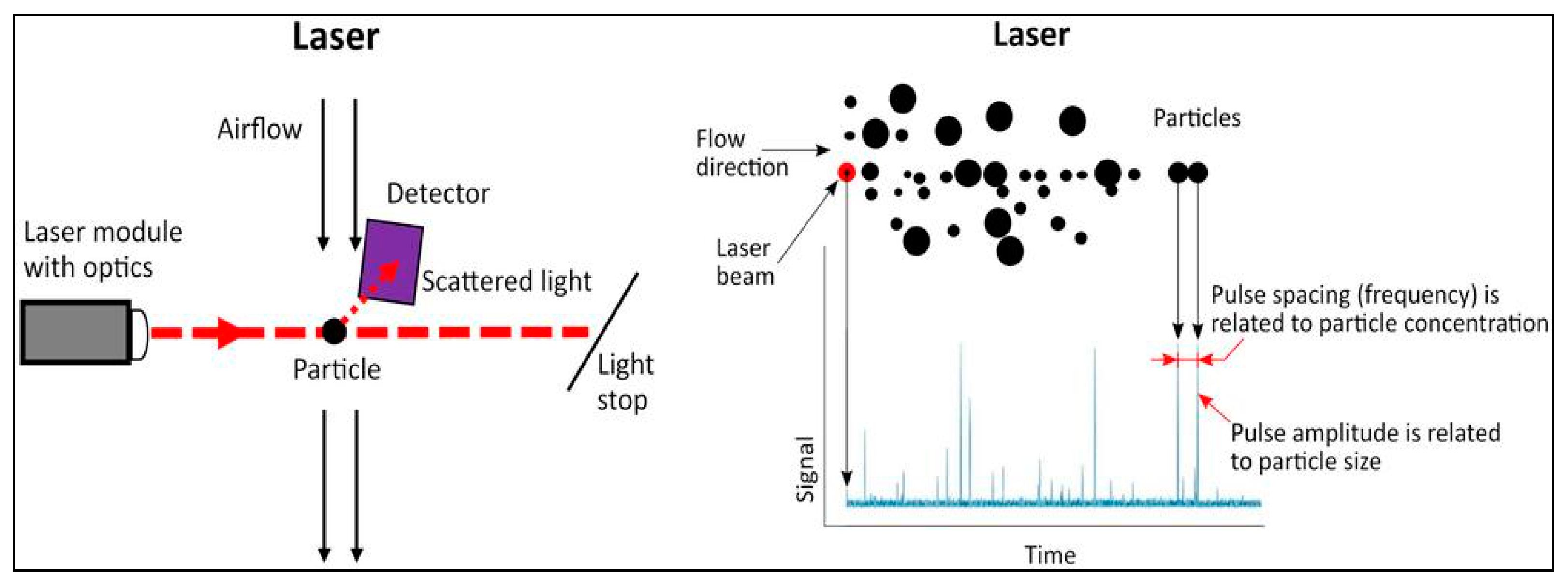
Figure 1. Functional scheme of uRADMonitor® optical particulate matter sensor.
Atmosphere 14 00840 g001
Figure 2. uRADMonitor® Server Specs: the backend server (see [47]).
Atmosphere 14 00840 g002
Figure 3. The map of the top five most populated cities of Romania. (a) All seven sensors are on the map. The location of selected uRADMonitor® sensors in (b) București, (c) Timișoara, (d) Cluj-Napoca, (e) Constanța, and (f) Iași.
Atmosphere 14 00840 g003aAtmosphere 14 00840 g003b
Figure 4. Location of the TM2 station in Timișoara—part of the official air quality monitoring network.
Atmosphere 14 00840 g004
Figure 5. Annual mean values of daily PM10 concentration levels in the selected cities, as derived from the uRADMonitor® network for 2021; the orange line marks the WHO-recommended value [57].
Atmosphere 14 00840 g005
Figure 6. (a) The 90.4 percentile and (b) 50 percentile indicators for PM10 concentrations at an annual scale in selected cities, as derived from the uRADMonitor® network for 2021. The orange lines mark the EEA threshold values of 50 μg/m3 and 20 μg/m3 [56].
Atmosphere 14 00840 g006
Figure 7. (a) The maximum average daily value of PM10 concentration level and (b) the number of days with PM10 above the threshold at an annual scale in the selected cities, as derived from the uRADMonitor® network for 2021. In (b), the orange line marks the WHO-recommended value [57].
Atmosphere 14 00840 g007
Figure 8. Comparison of five EEA indices based on data from 2021 provided by uRADMonitor® sensors (TIM-235 and TIM-0C2) and ANPM sensors (TM2-GRAV and TM2-LPSM) for Timișoara. The EEA indicators: annual mean (p1y), 90.4 percentile (p90), 50 percentile (p50), maximum daily value during the year (dmax), and number of days with daily values above the threshold of 50 µg/m3 (above 50).
Atmosphere 14 00840 g008
Figure 9. Daily mean values of PM10 concentration measured by TIM-0C2.
Atmosphere 14 00840 g009
Table 1. Sensor label, identification, position (latitude, longitude), and city.
LabelSensor IDSensor TypeLatitudeLongitudeCityNo. of Logged Days
BUC-02216000022SMOGGIE PM44.40826.120București353
BUC-2AF820002AFA344.41626.036București356
CTA160000F6SMOGGIE PM44.18028.632Constanța361
C-NAP160000CASMOGGIE PM46.75623.567Cluj-Napoca337
IASI1600021FSMOGGIE PM47.13927.657Iași345
TIM-23516000235SMOGGIE PM45.75421.226Timișoara309
TIM-0C2160000C2SMOGGIE PM45.76121.251Timișoara359
Table 2. ANPM data for days with PM10 concentration levels above 50 µg/m3 for the 15 February to 8 March 2021 interval.
DatePM10-GRAV [µg/m3]PM10-LPSM [µg/m3]
25 February 202175.1375.12
26 February 202169.1370.64
27 February 202157.6071.26
4 March 202177.3182.92
5 March 202167.0567.82
Table 3. Correlation coefficients of the PM10 daily values from our two TIM sensors and the ANPM TM-2 sensor for 2021.
Sensors PairNumber of Valid Simultaneous MeasurementsCorrelation Coefficient
TM2-GRAV vs. TIM-0C23210.564
TM2-LPSM vs. TIM-0C23350.584
TM2-GRAV vs. TIM-2352730.723
TM2-LPSM vs. TIM-2352890.725
Disclaimer/Publisher’s Note: The statements, opinions and data contained in all publications are solely those of the individual author(s) and contributor(s) and not of MDPI and/or the editor(s). MDPI and/or the editor(s) disclaim responsibility for any injury to people or property resulting from any ideas, methods, instructions or products referred to in the content.