4.1. Sensitivity to PBL Parameterization
D17 showed that based on 4DWX output at DPG, larger CBL depths are simulated in coarse domains than in fine domains, especially in mountainous terrain. The 4DWX output alone does not allow an investigation of the influence of physical parameterizations since it only uses the nonlocal YSU scheme. We, therefore, perform quasi-idealized simulations for the same area (DPG) with WRF at 10 and 3.3 km grid spacing (using the five widely used PBL parameterization schemes mentioned above) during a summer day, on 1 July 2013. With values of
r = 0.44, defined as the correlation between terrain elevation and the maximum daily CBL height (relative to mean sea level), this day was representative of days with typical CBL growth, and thus the simulated differences between coarse and fine domains are similar to those in the 2-yr climatology. Other details of these simulations are given in
Section 2.3 and
Section 3.2.
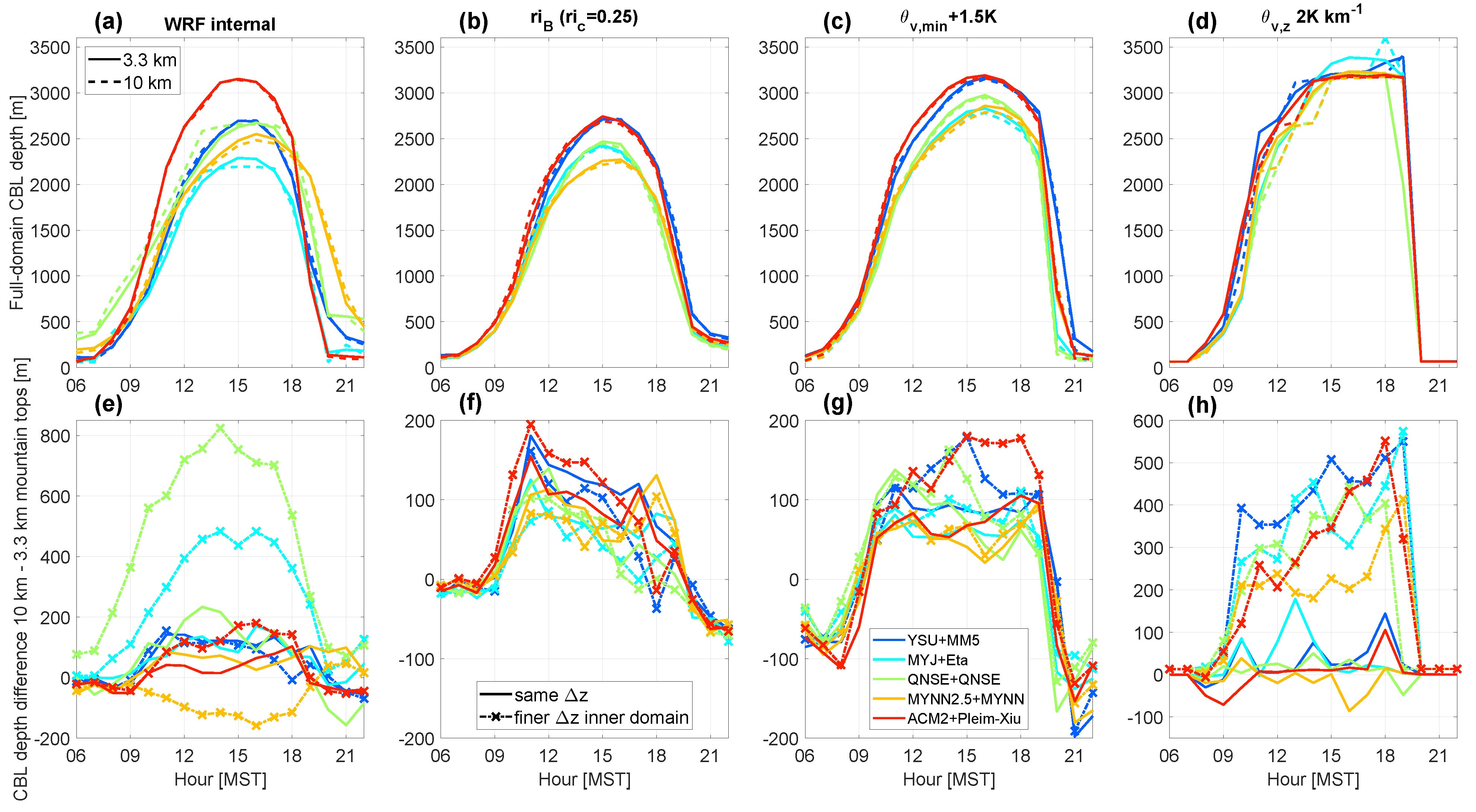
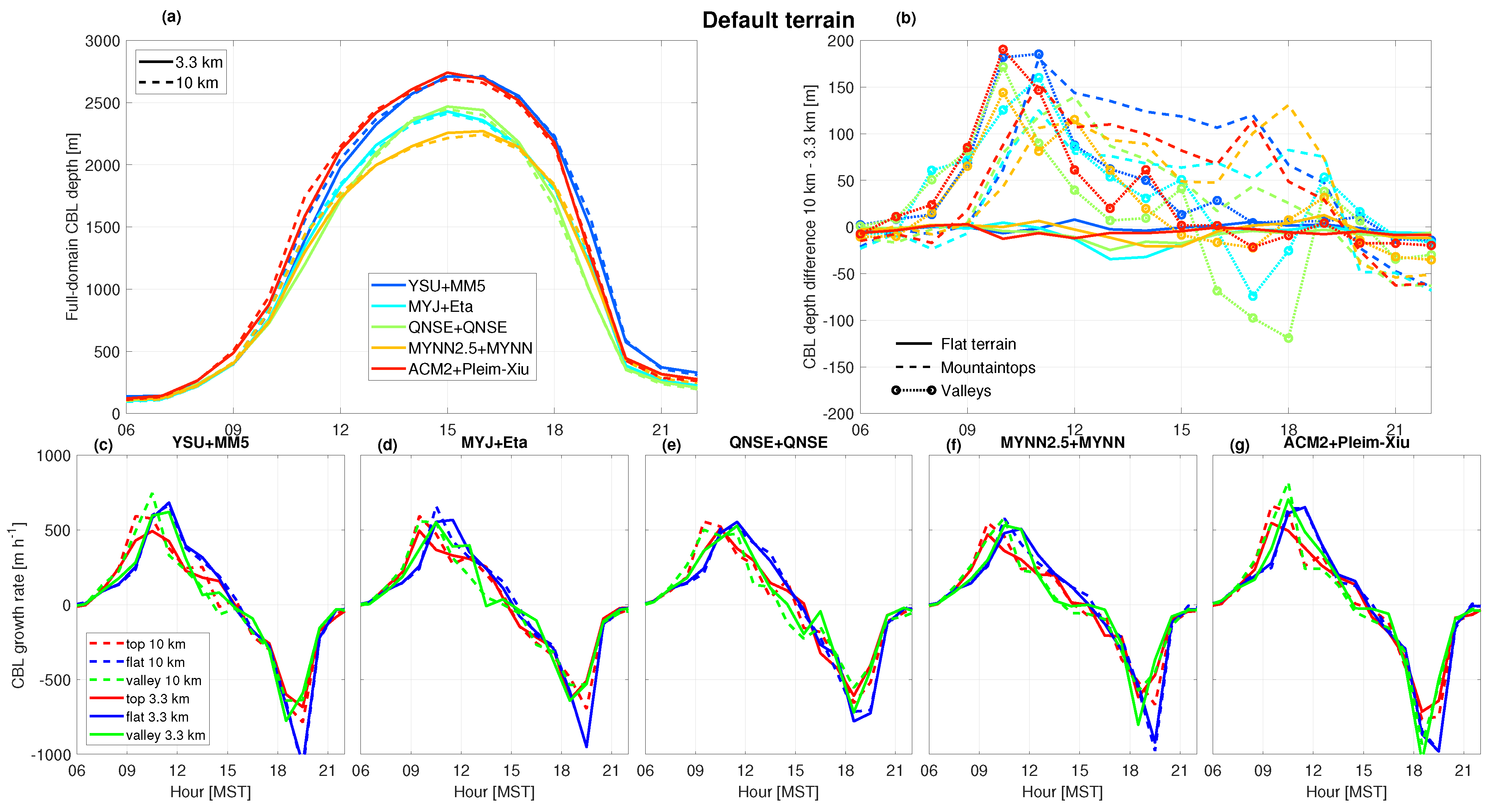
All simulations using different PBL schemes show clear convective PBL evolution leading to maximum CBL depths at 15:00 MST (
Figure 3a). The nonlocal schemes YSU and ACM2 simulate maximum CBL depths of around 2750 m, whereas the local schemes MYJ, QNSE, and MYNN2.5 simulate CBL depths in the range of around 2300–2500 m. This is in line with previous studies that also showed that nonlocal schemes simulate deeper CBLs than local schemes over both flat and complex terrains [
1,
3,
4].
Over flat terrain, the differences in CBL depths between the coarse and fine domains are minimal and around zero throughout the day among all PBL schemes (solid lines in
Figure 3b). This is in line with the 2-year climatology of D17, and smaller than reported by [
5]. Over mountaintops (recall there are 53 available grid cells in the domain; see
Table 3) and valleys (28 available grid cells) a clear tendency for larger CBL depths in the coarse domain was simulated (dashed lines in
Figure 3b). Over mountaintops, CBL depths remain larger in the coarse domain throughout the day, with a maximum difference between coarse and fine domains of around 150 m. Differences are about 5–10% larger in the coarse domain, relative to the CBL depths in the fine domain. At the time of maximum CBL depth (15:00 MST), the difference is around 100 m across all PBL schemes. In the valleys, differences in CBL depths between the coarse and fine domains gradually decrease to a minimum at around 15:00 MST. Although the differences in CBL depths in this one-day case study are slightly smaller than reported for the two-year comparison by D17, our comparisons show that PBL parameterization itself is not critical in explaining the differences between coarse and fine domains in mountainous terrain.
The differences in morning CBL depths between the coarse and fine domain increase more rapidly in valleys than over mountaintops (circled lines vs. dashed lines, resp., in
Figure 3b). In our simulations, this effect is evident for all PBL parameterization schemes as shown by CBL growth rates in
Figure 3c–g. Slower CBL growth in the morning transition period in a resolved valley has been related to cold-air pool formation and increased morning stability in the resolved valley (D17). Also over mountaintops, all PBL schemes simulate a faster CBL growth during the morning in the coarse domain (
Figure 3c–g). In general, stability is weaker in the atmosphere above the mountaintops in the coarse domain compared to the fine domain, making it easier to heat the nocturnal boundary layer in the morning. Moreover, a mountaintop in a fine domain is better resolved, with surrounding grid cells on different azimuth angles, whereas a coarse domain “mountaintop” has a flatter surface and processes at the surface would react differently to solar heating to which subsequent CBL growth responds. Additionally, over more resolved terrain, smaller-scale terrain-driven flows will develop resulting in more pronounced cold-air advection from lower terrain, thereby counteracting CBL growth. In contrast to mountainous terrain, the differences in CBL growth over flat terrain (blue lines) are minimal at all times (
Figure 3c–g).
The patterns and values apparent in this one-day case study are similar to the findings of D17 (see Figure 8c in D17). We thus conclude that differences in CBL depths between domains with different grid spacings tend not to depend on the specific PBL physics parameterization among those we tested. As mentioned previously in
Section 3.2, we also investigated the influence of different CBL top derivation methods on our results, but CBL depths remained larger in coarse-grid domains, irrespective of the method used (see
Appendix A). Since in our simulations physical parameterization and CBL top derivation method can be excluded as relevant drivers of differences between coarse and fine domains in complex terrain, we now focus our investigation on the influence of terrain smoothing.
4.2. Sensitivity to Terrain Smoothing
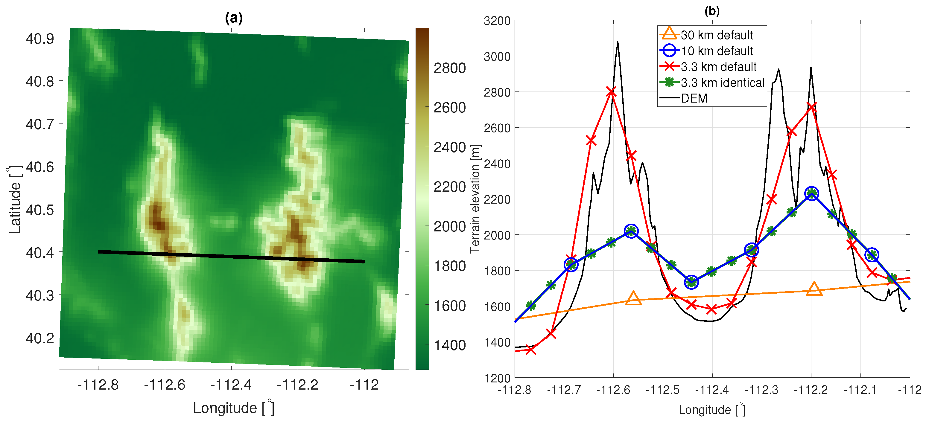
We investigate the role of terrain smoothing directly on simulated CBL depths using the same case study as in the previous subsection. Our approach consists of replacing the terrain elevation on the fine grid (3.3 km) with the terrain elevation from the coarse grid, as described in
Section 3.3 and illustrated in
Figure 2b. We refer to these as
interpolated-terrain simulations. Smoothing of the mountainous terrain in coarse domains leads to changes in the characteristics (scale and intensity) of terrain-driven circulations (dynamic effects) and changes in the height of the CBL top above the terrain (static effects). By keeping terrain elevation constant while everything else varies between coarse and fine domains, we can further attempt to eliminate the effect of terrain smoothing and isolate the effect of PBL representation at different grid spacings. We expect differences in CBL depths between coarse and fine domains over mountainous terrains to reduce to values similar to those over flat terrain, hence around zero. This would indicate that sub-grid scale processes affect the simulated CBL depth over mountainous terrain.
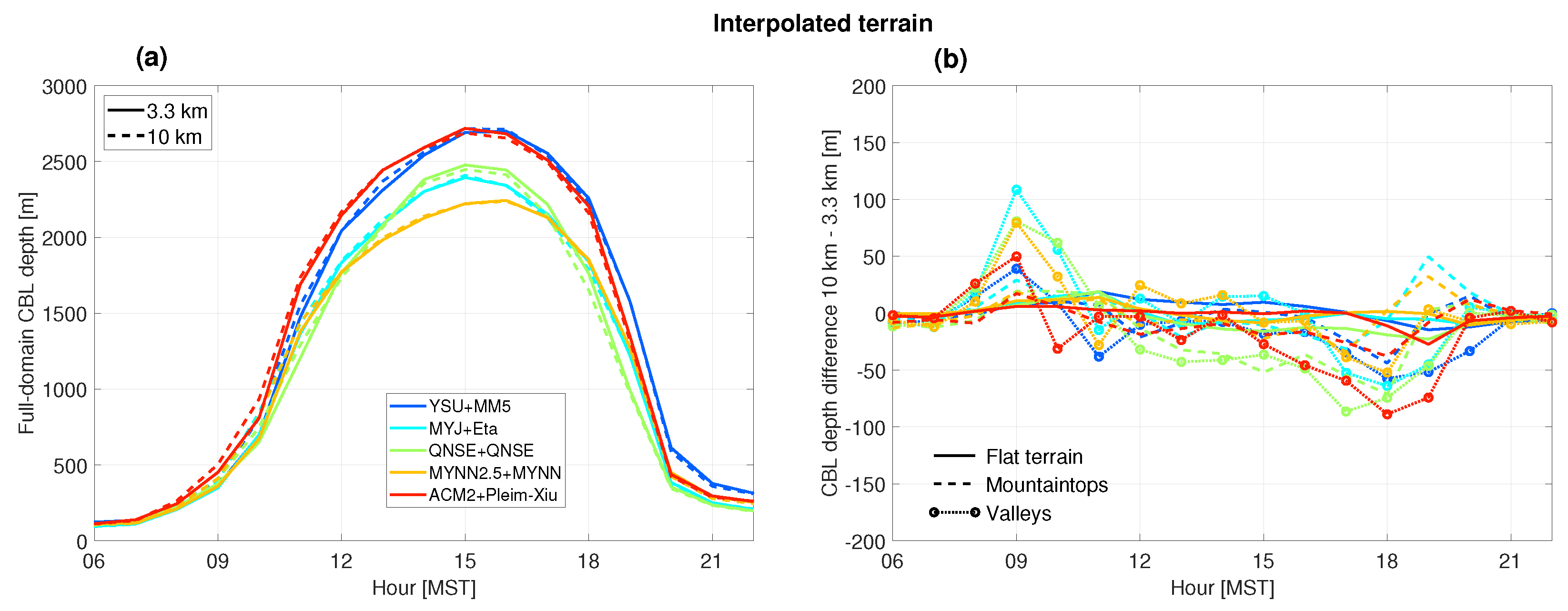
Indeed, the CBL depth differences between coarse and fine domains reduce largely to around zero in mid-afternoon, when CBLs are highest, over mountaintops and in valleys across all PBL schemes (dashed and circled lines in
Figure 4b). The effect is clearest over mountaintops, where CBL depth differences are reduced from around 100 m in the default terrain simulations (
Figure 3b), to around zero in the interpolated-terrain simulations in the cases of most PBL schemes (
Figure 4b). An exception is the QNSE scheme, which produces negative differences in CBL depths in valleys and over mountaintops from around noon. We obtain similar results using larger grid spacing comparisons (i.e., 30- and 10 km grid spacing, see
Supplemental Material Figure S1).
Note, that the CBL depth differences are not completely reduced to zero. We consider at least three reasons. First, this is a consequence of using and comparing models on different grid spacings. Even over flat terrain, differences in CBL depths among models at different grid spacings exist see, e.g., [
5] and
Figure 3b. Thus, in our simulations that use and compare models with identical—but mountainous—terrains, differences between coarse and fine domains are still to be expected. In convective situations, [
5] found this effect to be more apparent for TKE-based schemes, and related this to a larger grid spacing dependency compared to nonlocal schemes. We also find the largest differences result from the TKE-based schemes (compare, e.g.,
Figure 3b and
Figure 4b).
A second factor that might explain CBL depth differences between coarse and fine domains is the consequence of using the aggregation approach to compare domains of different resolutions over mountainous terrain. Averaging the eight surrounding grid cells around a mountaintop or a valley on a fine grid does not necessarily lead to precisely the same values that are on a coarse grid, even though terrain elevations at the locations common to both domains are identical (see
Figure 2b). Similarly, aggregated CBL depths might also lead to small differences between domains. This was also pointed out by [
5], who found that minor terrain elevation differences can lead to larger CBL depths in coarse domains.
Third, finer domains improve the simulation of terrain-driven flows, including slope flows [
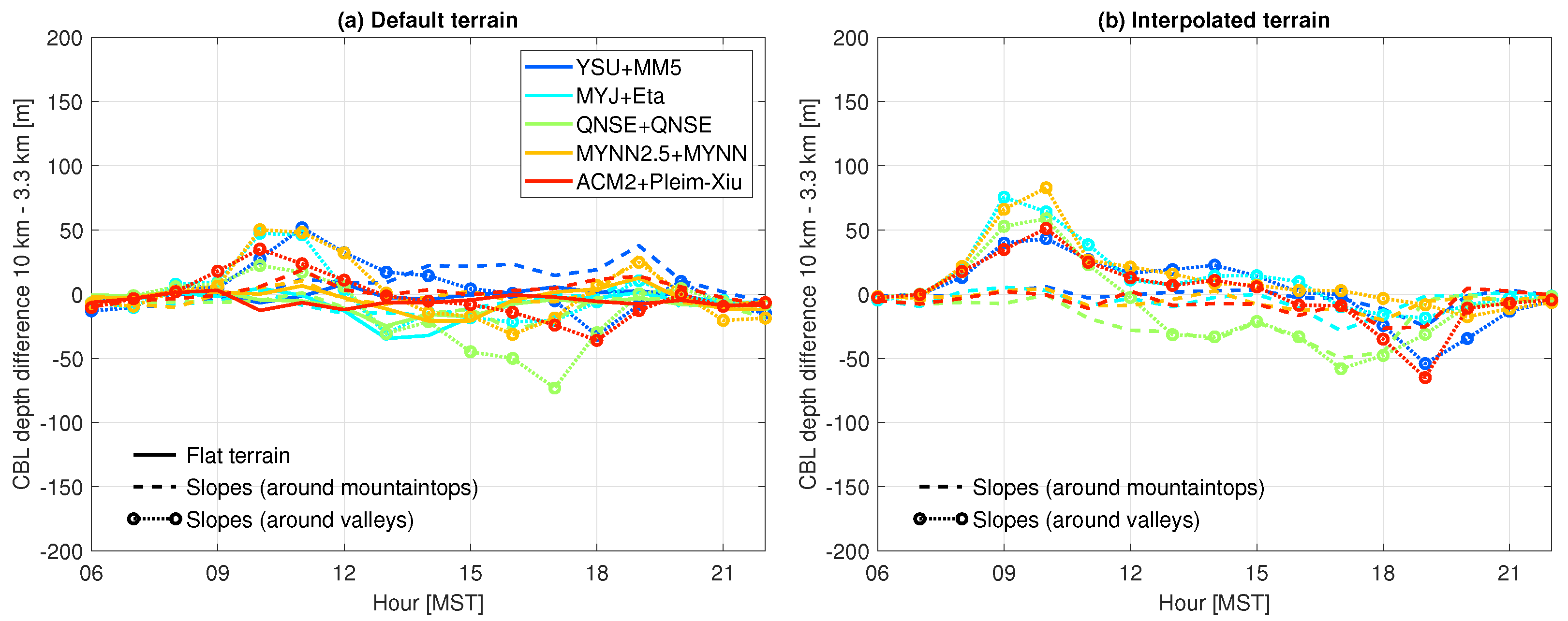
34]. Since these flows have an impact on CBL depths, differences in CBL depths between the coarse and fine domains are expected. We explore this impact on CBL depth differences over slopes next. We define two different types of slopes: slopes surrounding mountaintops, and slopes surrounding valleys (
Table 3). In the default terrain simulations, the differences in CBL depths between coarse and fine domains are slightly larger over slopes than over flat terrain (
Figure 5). The differences in CBL depths over slopes are, however, smaller than over mountaintops and in valleys (compare
Figure 3b and
Figure 5a). For interpolated-terrain simulations, CBL depth differences over slopes surrounding mountaintops decrease mostly to around zero, whereas the CBL depth differences over slopes surrounding valleys increase relative to default terrain. Notably, over the slopes surrounding valleys, we find larger CBLs in the morning and smaller in the late afternoon, similar to the interpolated terrain simulations of valleys (
Figure 4b).
Because wind speed and
H are major factors affecting CBL growth, we investigate their role in causing these CBL depth differences between the simulations, see
Figure 6 and
Figure 7 for absolute differences, and
Supplemental Figures S2 and S3 for relative differences. We find lower values of
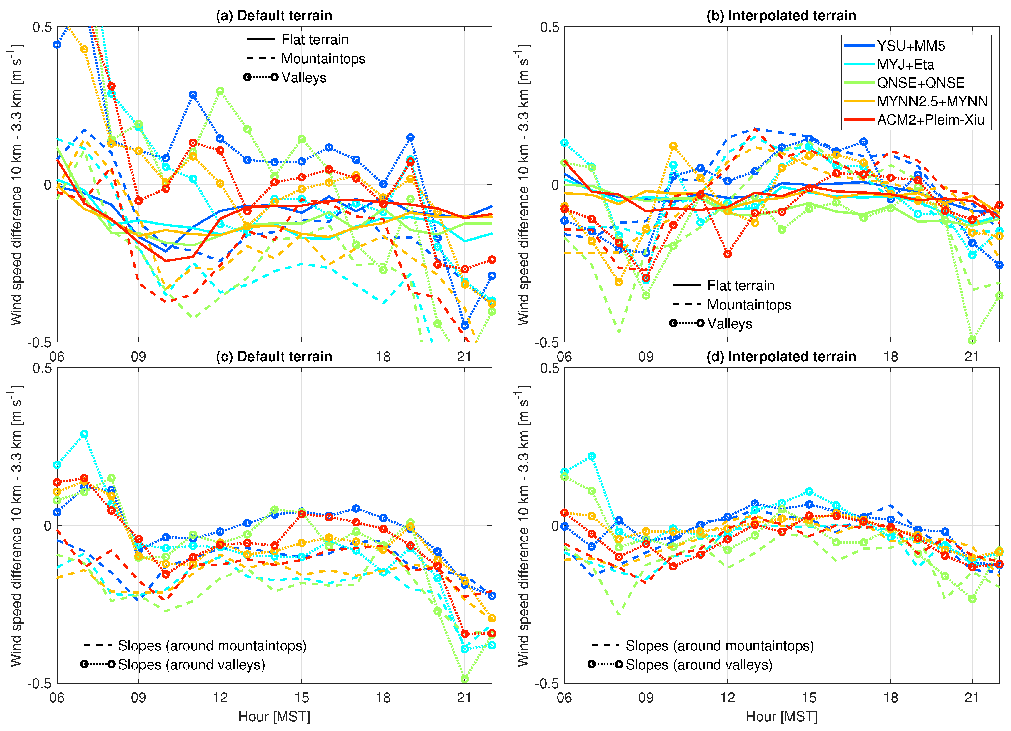
H and wind speeds over mountaintops in coarse vs. fine domains (
Figure 6a and
Figure 7a). The differences diminish when terrain is interpolated (
Figure 6b and
Figure 7b, resp.). Better-resolved terrain enhances winds over mountaintops but reduces winds in valleys due to increased sheltering, also affecting
H.
We find larger differences in
H over slopes surrounding mountaintops and valleys (
Figure 6c), than over mountaintops and in valleys themselves (
Figure 6a), persisting in interpolated-terrain simulations (
Figure 6d). In contrast, we find smaller differences in wind speed over slopes surrounding mountaintops and valleys (
Figure 7c), than over mountaintops and in valleys (
Figure 7a), but the differences are virtually zero when the terrain is the same in both domains (
Figure 7d). This result implies that the ability to resolve slopes has a large impact on the magnitude of the simulated winds. Nevertheless, the differences in
H in default terrain settings clearly do not explain the differences in CBL depths between coarse and fine domains, as was also noted by D17.
4.3. CBL Evolution in Three Study Areas
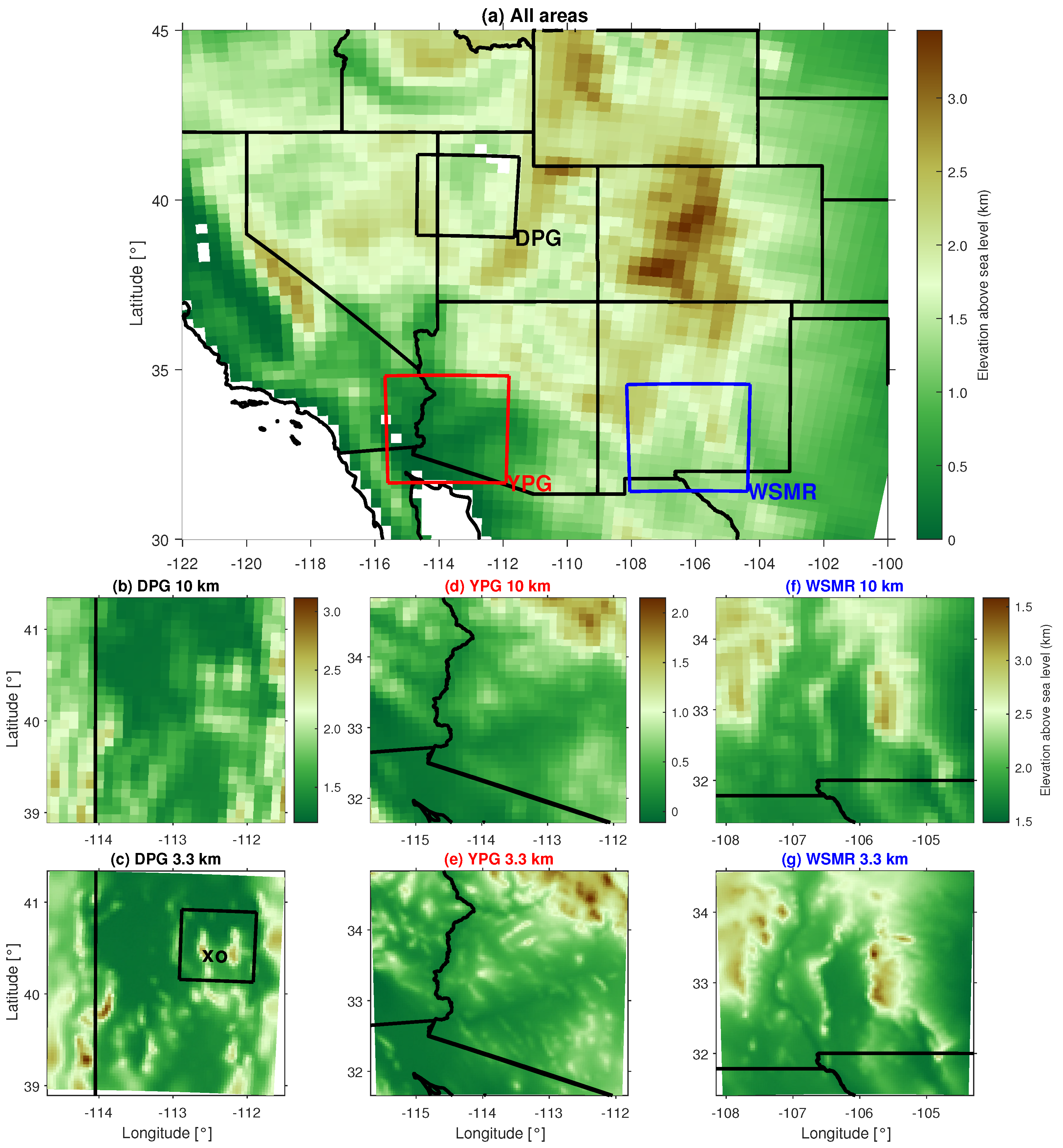
To investigate whether the CBL depth differences depend on the geographical area, we expand our investigation to three different areas with different terrain and climates (see
Figure 2). Diurnal PBL evolution is similar among the three different domains, with the deepest CBLs at WSMR (
Figure 8). CBLs are shallowest at DPG, except for during summer when YPG has the lowest afternoon CBL depths, corresponding with the earlier onset of the monsoon season in Arizona [
32,
35]. Maximum afternoon CBL depths in summer range from ∼1700 m at YPG to ∼2300 m at WSMR (
Figure 8). CBL depths are very small in winter at DPG, which has a colder climate and is subject to more snow cover than the other areas. The geographical and temporal (seasonal and diurnal) variability of the CBL is consistent with other studies of CBL depths over the same areas [
32,
36].
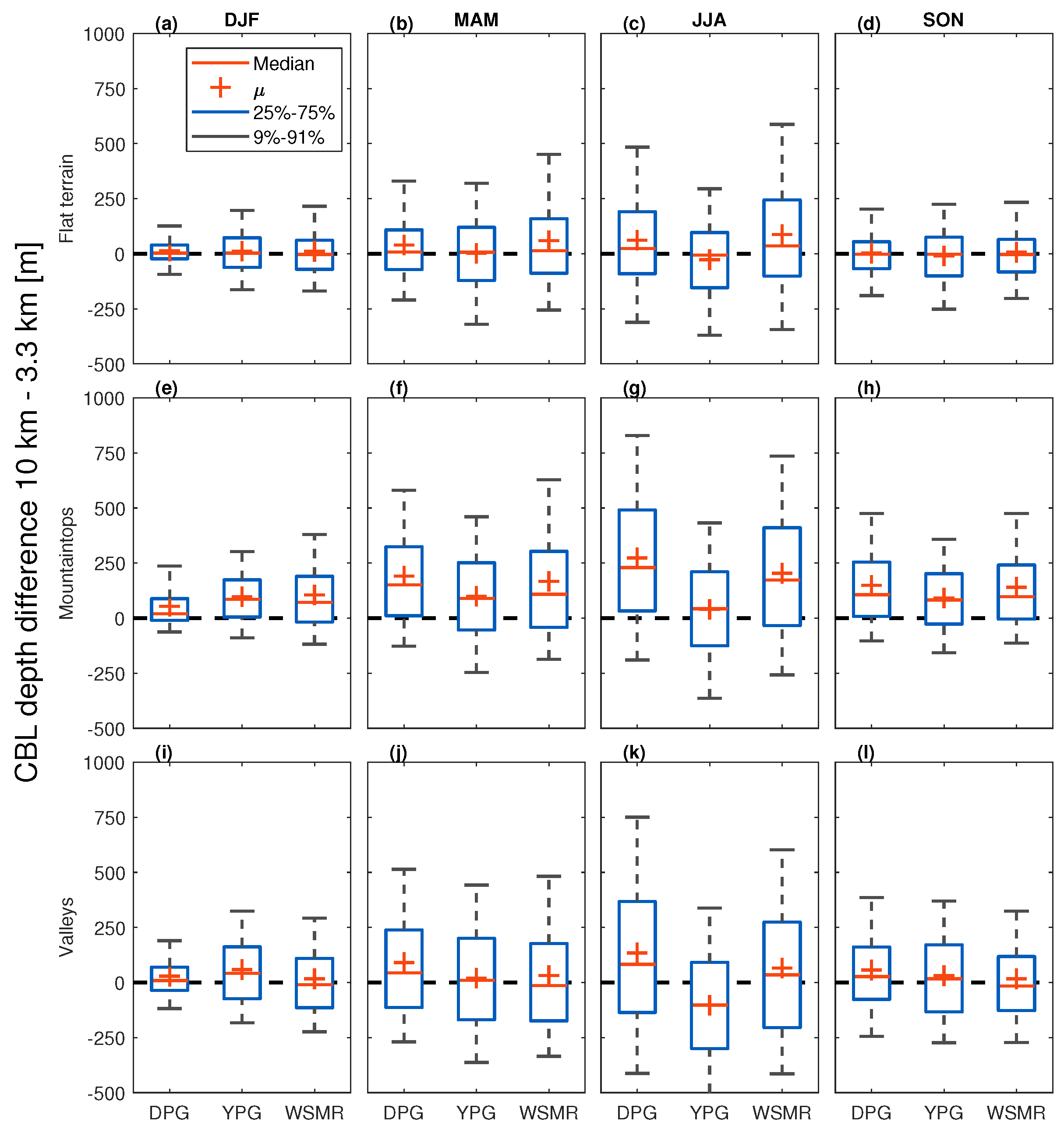
Over flat terrain, the differences in CBL depths between the coarse and fine domains are small during all seasons and at all locations (
Figure 9a and
Figure 10a–d). The CBL depths tend to be somewhat smaller (by ∼1%) in the coarse domain in the early afternoon, but somewhat larger (by ∼2%) in the late afternoon (maximum value is around 2% for WSMR at 18:00 LT in summer months,
Figure 9a). These minor differences are consistent with the findings of [
5], and in agreement with D17, who compared CBL depths at DPG only. Relative to maximum CBL depths (
Figure 8), the mean differences in CBL depths between coarse and fine domains are minimal, however, (
Figure 10a–d). Although variances in CBL depth differences between coarse and fine domains are higher in summer than in winter (as a consequence of the larger variability of CBL depths in summer), they are equally spread around zero (
Figure 10a–d), which is similar to the findings of D17.
CBL depth differences between coarse and fine domains are larger in parts of a domain that are mountainous (
Figure 9b,c and
Figure 10e–l). Generally, the largest differences in CBL depths are found over mountaintops in all geographical areas, throughout the day, and peak during the late afternoon in all seasons (
Figure 9b and
Figure 10e–h). An exception is at YPG in summer, where the differences in CBL depths between coarse and fine domains over mountaintops are comparable to those over flat terrain (
Figure 10g). Differences in CBL depths also tend to be larger in summer than in winter when they reach relative maximum differences of about 10%, but in some locations these relative differences can become larger than 25% (see
Figure S4 in Supplemental Material). Mountaintops were selected based on
−40 m, as explained in
Section 3.1; see also
Table 3. For subselections of steeper and higher mountaintops, the differences in CBL depths are larger in all areas (see
Figure S5 in Supplemental Material).
The results are less clear in valleys than over mountaintops, with both positive and negative differences in CBL depths between the coarse and fine domains (
Figure 9c). D17 related this to the ability of fine-grid simulations to resolve subsidence over the valley, cold-air pools, and upslope flows. The net result of these processes is a slower CBL growth in fine domains. In addition, valley orientation might play a role. All these factors might lead to a less straightforward signal in the comparison of CBL depths between coarse and fine domains in valleys than over mountaintops. The spread in the differences in CBL depths between coarse and fine domains does not depend on terrain, but it does depend on season in all three areas (
Figure 10), which is consistent with the findings of D17.
4.4. Sensitivity to Grid Spacing and Grid Spacing Ratios
D17 focused on CBL depth differences between 10 km and 3 km domains. Herein, we also examine the 30 km domain to explore the role of coarse grids that are more comparable to climate models, which nevertheless are often compared with observations at individual points (e.g., radiosoundings). The DPG, YPG and WSMR areas include a mixture of both complex and flat terrain, which is suitable for this investigation (see
Figure 1). For simplicity, we focus here on DPG only, because results are similar at YPG and WSMR (see
Supplemental Material Figures S6 and S7, resp.). We compare the 30, 10 and 3.3 km domains for the same 2-yr period. The terrain properties and number of available grid cells over flat terrain, mountaintops, and valleys are shown in
Table 3.
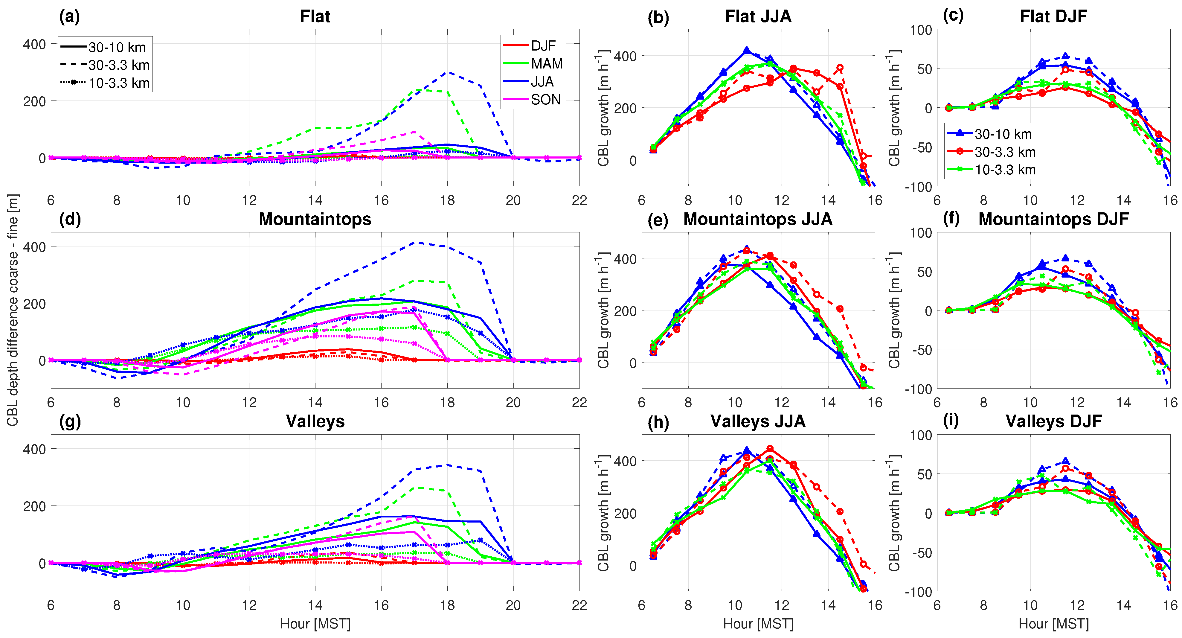
Simulations tend to produce larger CBL depths in coarse vs. fine domains, with the largest differences over mountaintops, followed by valleys and flat terrain (
Figure 11a–c). There is a delay in the decay of the CBL in the late afternoon in the coarser domains. This is related to the late-afternoon transition, which in general, is later for models run on coarser grids.
The differences between coarse and fine domains during morning and afternoon transition periods are quite apparent in the CBL growth rate (
Figure 11d–i). As was shown by D17 in their comparison of the 10 km and 3.3 km simulations, the largest differences in CBL growth rates between coarse and fine domains in summer are found over mountaintops (
Figure 11e). In valleys, the differences in CBL growth rates between coarse and fine domains are largest in the early morning but are also considerable in the early afternoon after 12:00 MST (
Figure 11h). Over flat terrain, the differences in CBL growth rates are similar between all compared coarse and fine domains in summer (
Figure 11b) and winter (
Figure 11c). In winter, differences occur later in the morning than during the summer, related to the typical later onset of CBL growth in winter (
Figure 11c,f,i).
Although at WSMR and YPG there are different delays and values for growth rates compared to DPG, the largest differences between coarse and fine domains are over mountaintops, followed by valleys (see
Figures S6 and S7 in Supplemental Material). This is also evident from the differences between daily maximum CBL depths in the course and fine domains (see
Figure S8 in Supplemental Material). However, part of the differences in daily maximum CBL depths over mountainous terrain (
Figure S8e–l) appears to depend on the grid spacing itself (and not necessarily different terrain smoothing), because differences in CBL depths between the 30 and 10 km domains are also larger over flat terrain at all locations in all seasons (
Figure S8a–d in Supplemental Material).
4.5. CBL Depths, Heights, and Interpolation in Mountainous Terrain
We investigated CBL depth evolution for simulations with different grid spacings where the same mountainous terrain is represented by resolved mountaintops (3.3 km grid spacing), lower mountaintops and shallower valleys (10 km grid spacing), to sloping terrain (30 km grid spacing), see
Figure 2b. Of particular interest in the current study is the CBL behavior over mountaintops and in valleys. We select a single mountaintop and valley to answer more directly the following questions. What are the implications if CBL depths over mountaintops are different in simulations with different grid spacings? And do CBL depths in coarse simulations converge toward CBL depths in fine simulations if we correct information on the coarse grid to account for sub-grid scale terrain? The mountaintop and valley locations were selected because they exhibit a gradual transition from fine to coarse grid spacing (
Figure 2b). The selected case study is the same as for previous subsections (1 July 2013).
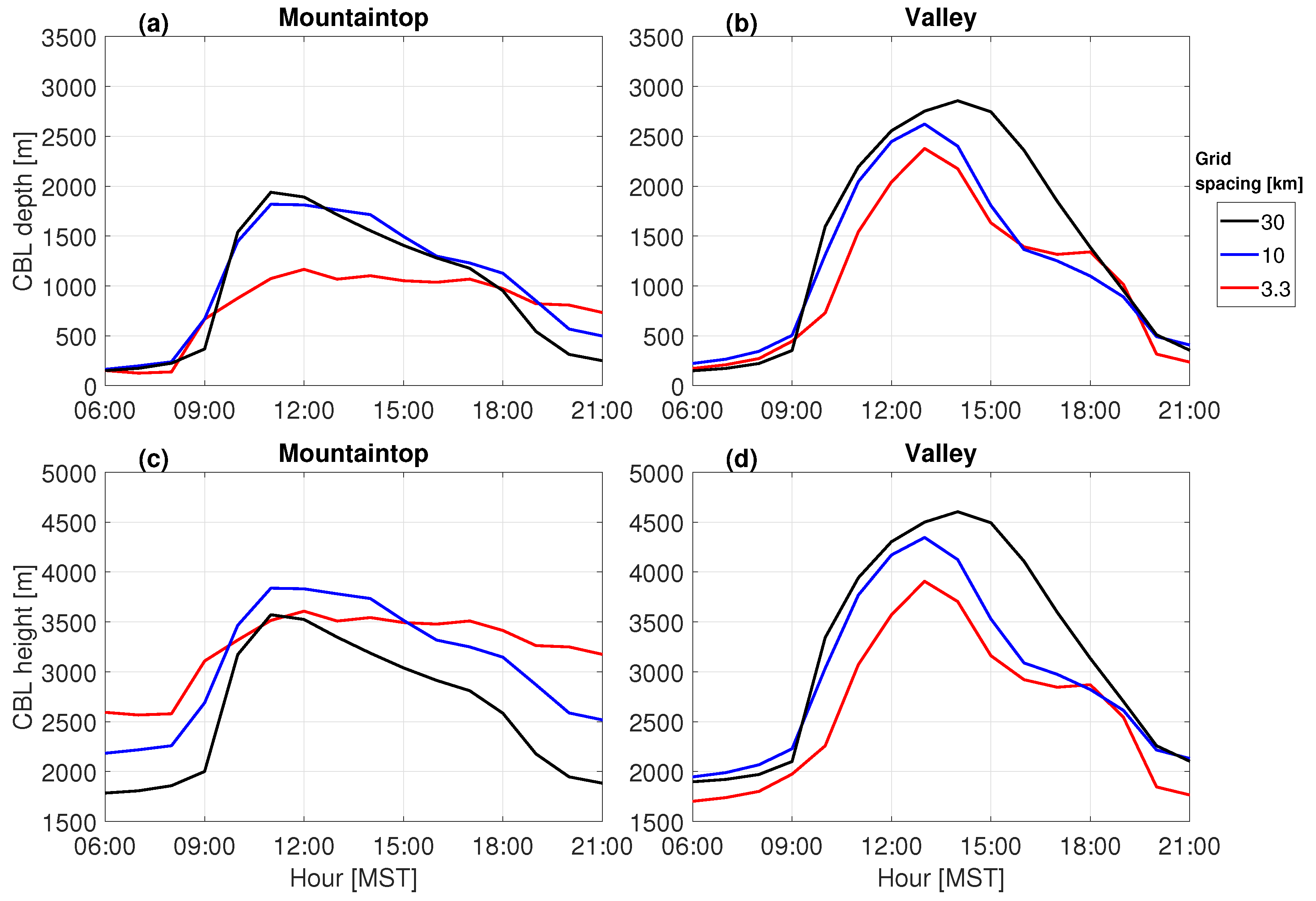
Over mountaintops, the coarse domain exhibits more rapid CBL development, but also delays in CBL onset and decay, compared to the fine domain (
Figure 12a). Conversely, in valleys, the fine domain exhibits a delayed onset and earlier decay of the CBL compared to the coarse domain (
Figure 12b). Daily maximum CBL depths are more similar in valleys than over mountaintops due to more consistent terrain elevation in valleys across the different grid spacings (
Figure 2b).
An interesting aspect of the deepening afternoon CBL is its increasing independence on underlying terrain [
19]. Correcting for subgrid terrain variability by using CBL
height, rather than
depth, enhances the agreement between coarse and fine domains (
Figure 12c). This means that CBL depth estimates from the coarse domain can be improved by correcting for the subgrid terrain variability. This is especially valid over unresolved mountaintops but not so much in unresolved valleys, where CBL heights and depths are similar (compare
Figure 12b and
Figure 12d), in agreement with the results of D17. We simulated another case study (10 July 2013) with slightly different CBL characteristics, but the conclusions remain similar: CBL growths and depths differ between coarse and fine domains, but using the CBL height and correcting for subgrid terrain variability increases the similarity between results on coarse and fine grids (see
Figure S9 in Supplemental Material).
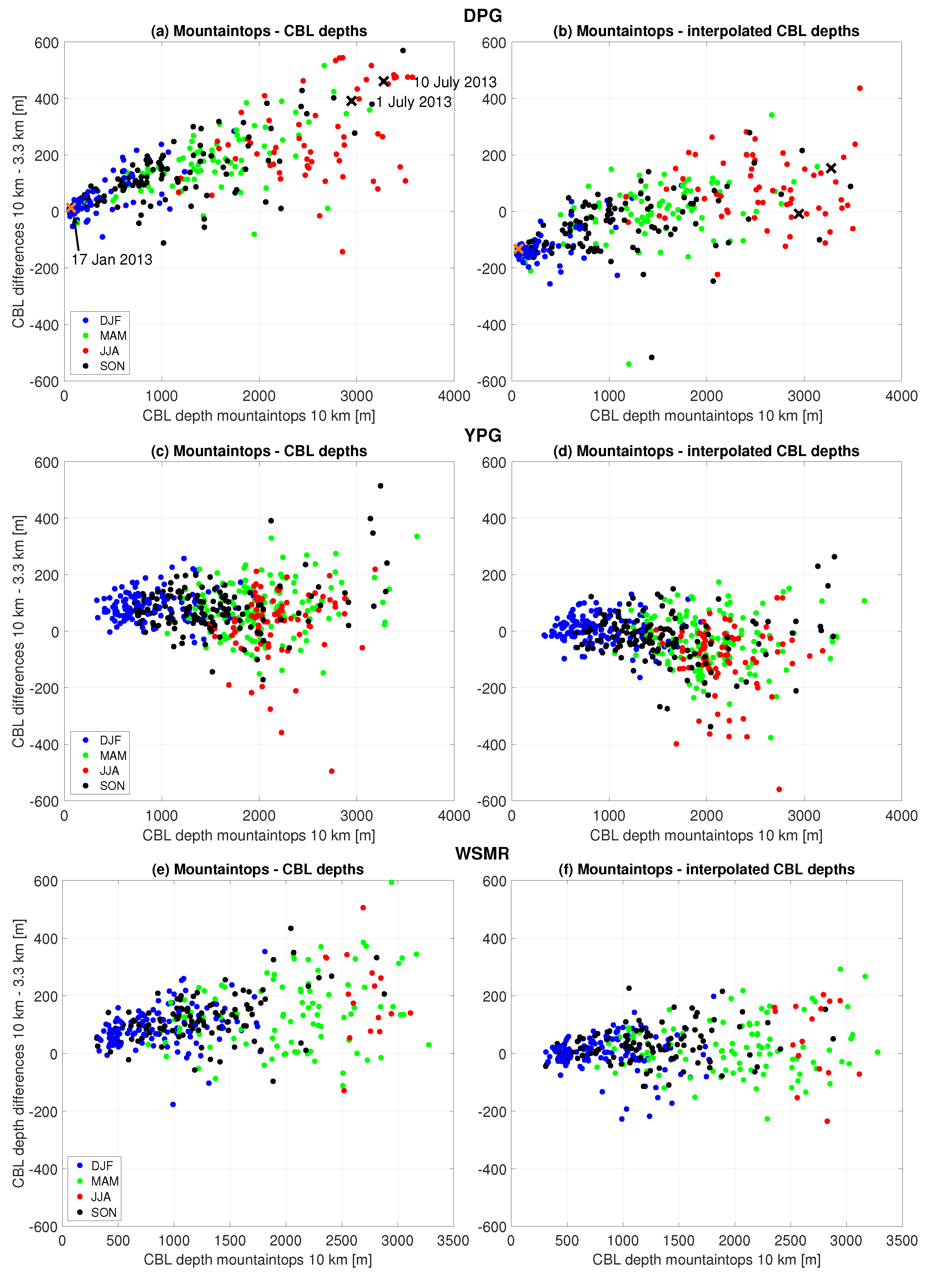
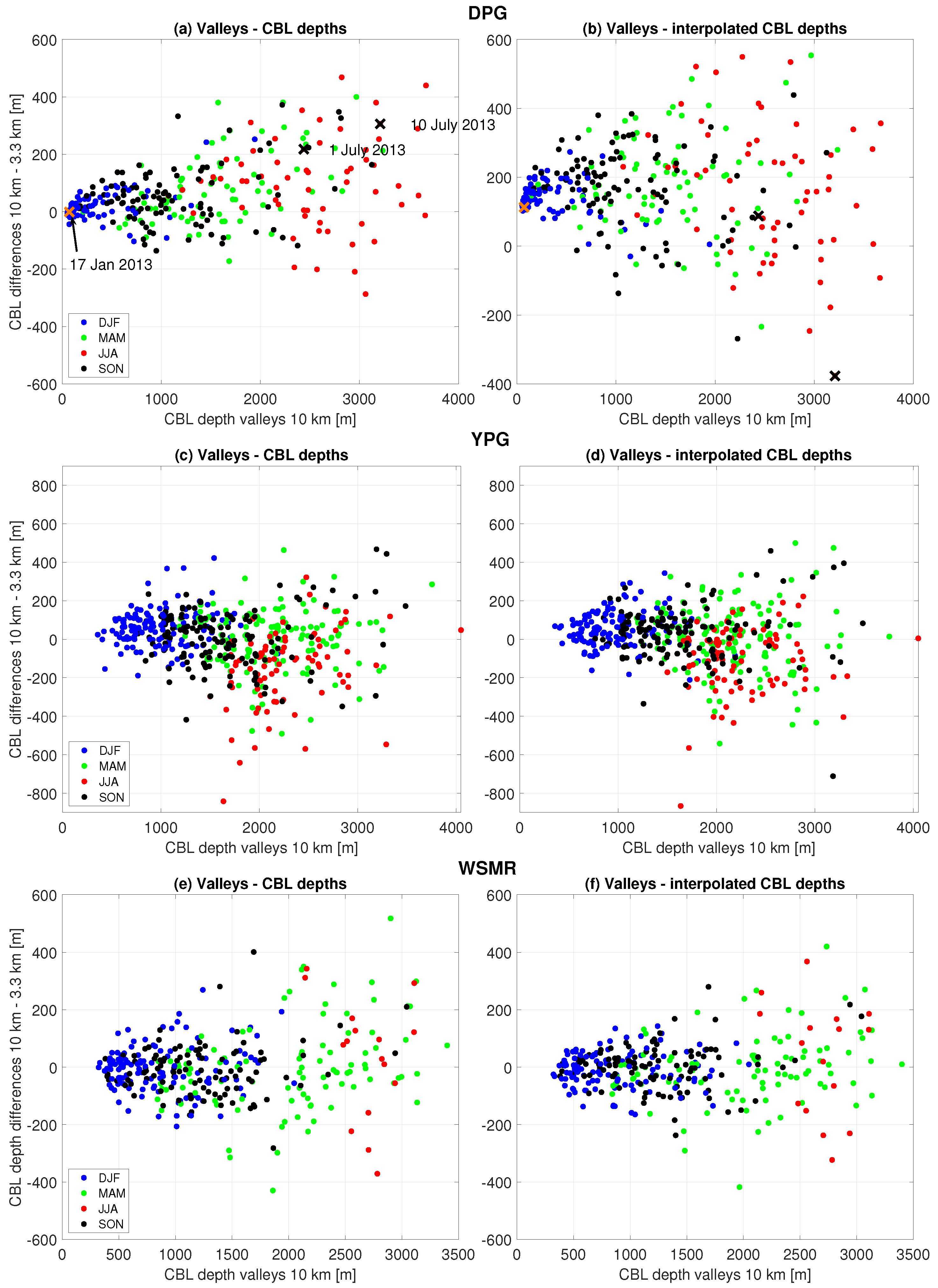
Building on the method proposed by D17, we interpolate CBL heights from coarse to fine domains and subsequently subtract fine-domain terrain elevations. This ’interpolated CBL depth’ approach assumes similar CBL heights in both domains, which is especially effective when deep CBLs occur. Application to different mountainous regions reveals correlations between coarse-domain CBL depth (x-axis) and the differences in CBL depths between the coarse and fine domains over mountaintops, especially at DPG and WSMR (
Figure 13a,e). At YPG, the differences in CBL depths between coarse and fine domains appear less correlated with the CBL depth (
Figure 13c). We further find greater seasonality in the maximum CBL depths (x-axis) at DPG (smaller CBLs in winter than in summer) than at YPG and WSMR (more seasonal spread of CBLs).
However, the approach shows limitations in valleys, with varying success in different regions (
Figure 14). This interpolated approach is valuable for regions with sufficiently deep and relatively level CBLs, where the CBL depth exceeds a certain terrain length scale. This length scale could be linked, for example, to the regionally averaged mountain elevation and to the grid spacing used in a model. Negative comparisons might arise for shallower CBLs, such as in the early morning, late evening, or winter. In valleys there is generally a larger scatter than over mountaintops, so careful consideration is required when applying the interpolation method (
Figure 14). Hence this correction is particularly effective during late spring, summer, and early fall when convection is strongest (D17).


