


Ocean Temperatures Do Not Account for a Record-Setting Winter in the U.S. West

Abstract
:1. Introduction
2. Materials
3. Methods
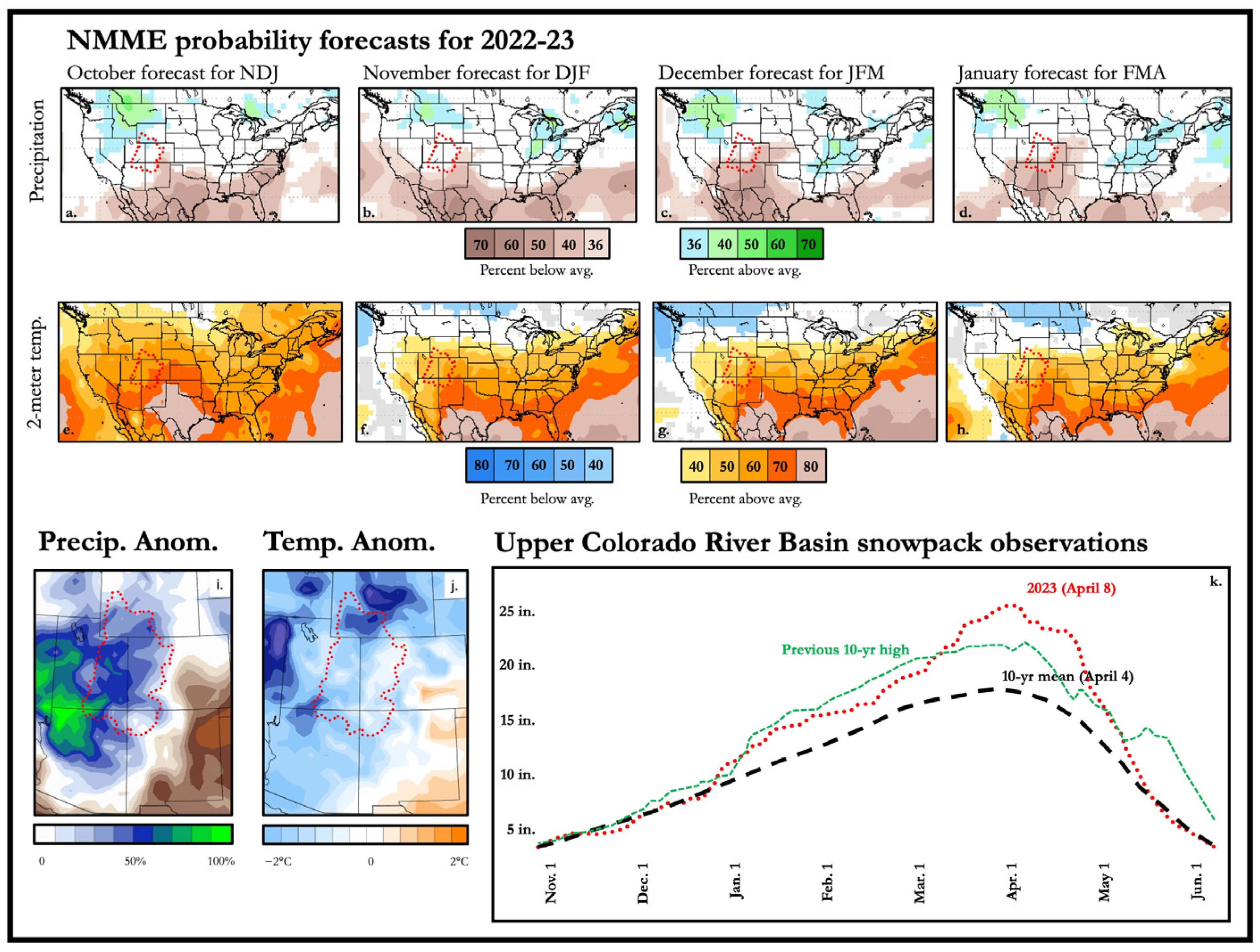
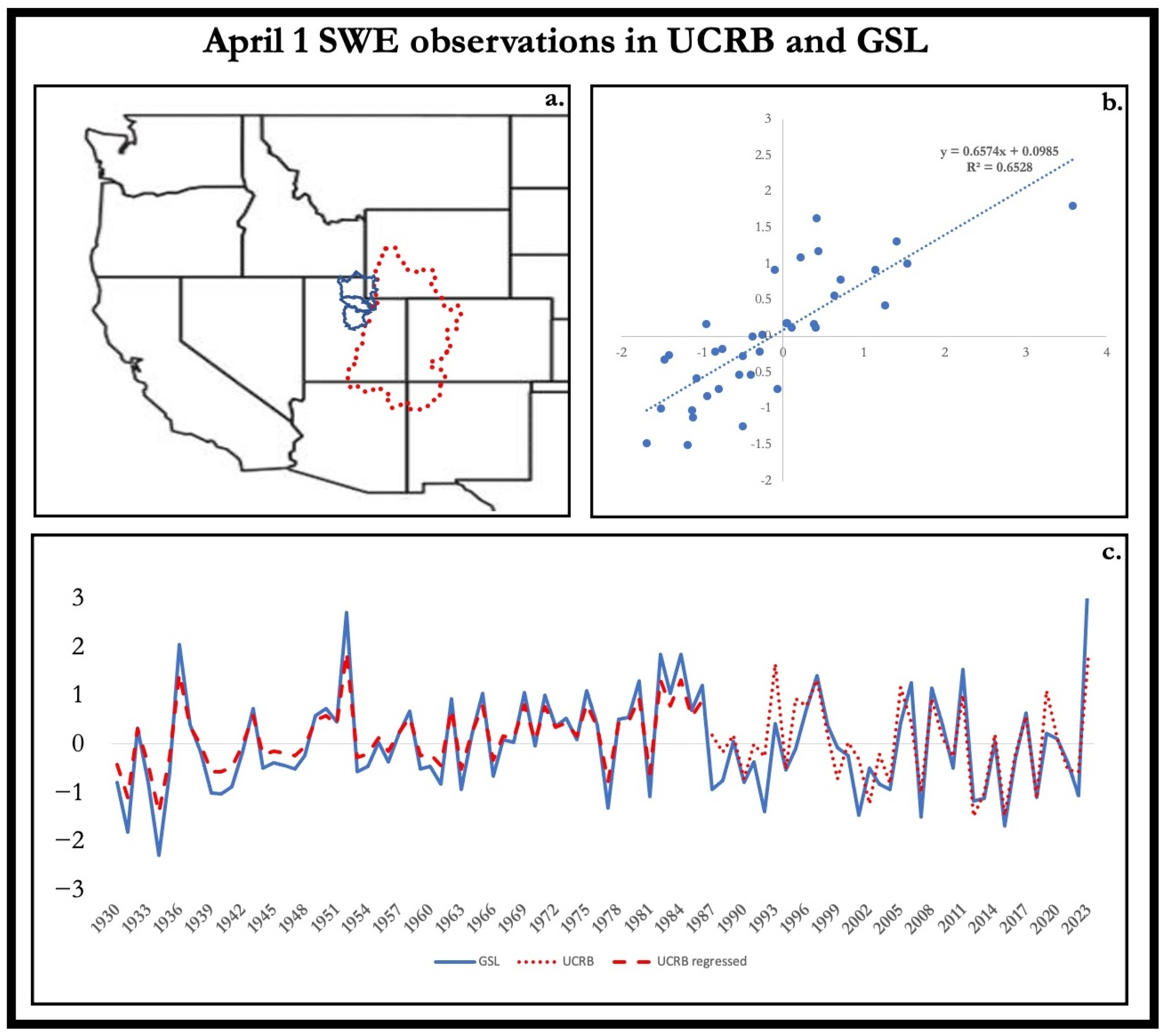
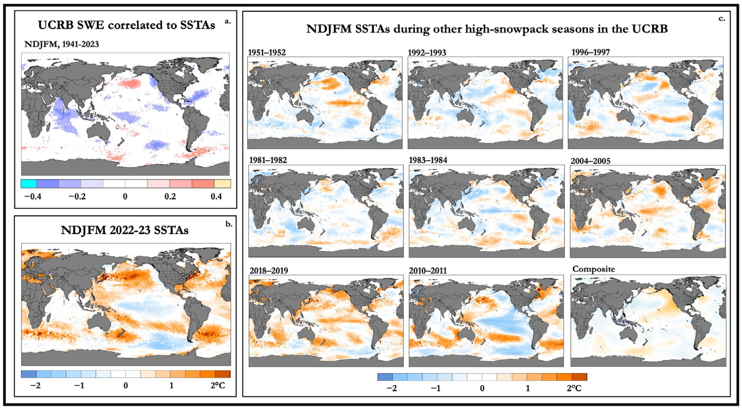
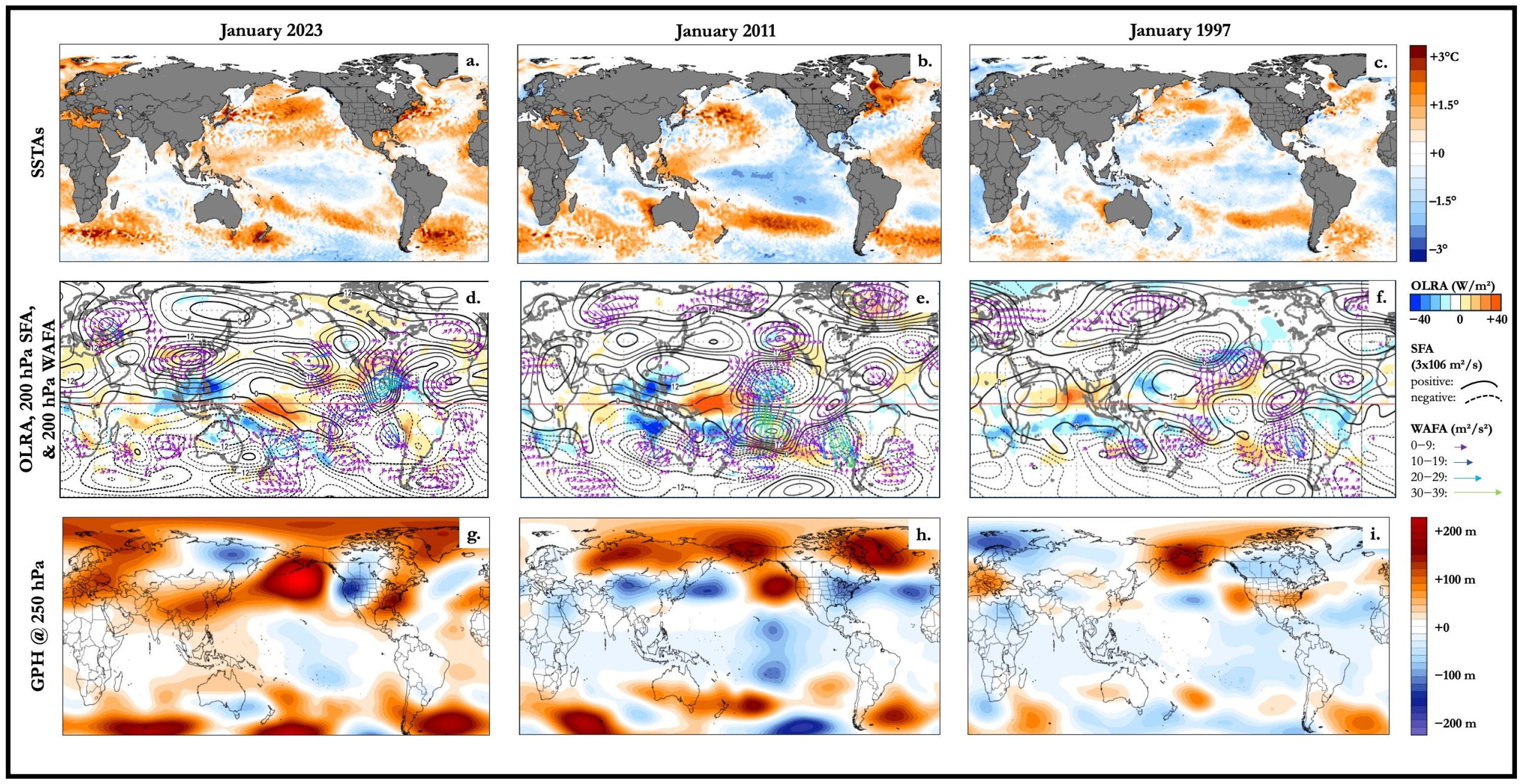
4. Results
5. Discussion
6. Conclusions
Author Contributions
Funding
Institutional Review Board Statement
Informed Consent Statement
Data Availability Statement
Conflicts of Interest
References
- Groundwater and Surface Water Considered a Joint Resource. Available online: https://www.usgs.gov/news/national-news-release/more-half-streamflow-upper-colorado-river-basin-originates-groundwater (accessed on 8 October 2023).
- Johnson, Z.F.; Stuivenvolt-Allen, J.; Mahan, H.; Meyer, J.D.; Miksch, M. Upper Colorado River Streamflow Dependencies on Summertime Synoptic Circulations and Hydroclimate Variability. J. Hydrometeorol. 2023, 25, 277–291. [Google Scholar] [CrossRef]
- Spahr, N.E.; Apodaca, L.E.; Deacon, J.R.; Bails, J.B.; Bauch, N.J.; Smith, C.M.; Driver, N.E. Water Quality in the Upper Colorado River Basin, Colorado, 1996–1998. U.S. Geol. Sur. Circ. 2000, 1214, 33. [Google Scholar]
- Swain, D.L.; Langenbrunner, B.; Neelin, J.D.; Hall, A. Increasing PrecipitationVvolatility in Twenty-first-century California. Nat. Clim. Chang. 2018, 8, 427–433. [Google Scholar] [CrossRef]
- Gershunov, A.; Shulgina, T.; Clemesha, R.E.S.; Guirguis, K.; Pierce, D.W.; Dettinger, M.D.; Lavers, D.A.; Cayan, D.R.; Polade, S.D.; Kalansky, J.; et al. Precipitation Regime Change in Western North America: The Role of Atmospheric Rivers. Sci. Rep. 2019, 9, 9944. [Google Scholar] [CrossRef] [PubMed]
- McCabe, G.J.; Wolock, D.M.; Pederson, G.T.; Woodhouse, C.A.; McAfee, S. Evidence that Recent Warming is reducing Upper Colorado River Flows. Earth Interact. 2017, 21, 1–14. [Google Scholar] [CrossRef]
- Woodhouse, C.A.; Smith, R.M.; McAfee, S.A.; Pederson, G.T.; McCabe, G.J.; Miller, W.P.; Csank, A. Upper Colorado River Basin 20th Century Droughts Under 21st Century Warming: Plausible Scenarios for the Future. Clim. Serv. 2021, 21, 100206. [Google Scholar] [CrossRef]
- Whitney, K.M.; Vivoni, E.R.; Bohn, T.J.; Mascaro, G.; Wang, Z.; Xiao, M.; Mahmoud, M.I.; Cullom, C.; White, D.D. Spatial Attribution of Declining Colorado River Streamflow Under Future Warming. J. Hydrol. 2023, 617, 129125. [Google Scholar] [CrossRef]
- Wood, A.W.; Liu, H.; Newman, A.J.; Bearup, L.A.; Leon Salazar, C. Improving the Prediction of Precipitation, Snowpack and Streamflow in Mountainous Basins through Ensemble-Based Variable-Complexity Watershed Modeling. In Proceedings of the AGU Fall Meeting, Chicago, IL, USA, 12 December 2022. [Google Scholar]
- Cayan, D.R. Interannual Climate Variability and Snowpack in the Western United States. J. Clim. 1996, 9, 928–948. [Google Scholar] [CrossRef]
- Hoell, A.; Hoerling, M.; Eischeid, J.; Wolter, K.; Dole, R.; Perlwitz, J.; Xu, T.; Cheng, L. Does El Niño Intensity Matter for California Precipitation? Geophys. Res. Lett. 2016, 43, 819–825. [Google Scholar] [CrossRef]
- Wang, H.; Kumar, A. Assessing the Impact of ENSO on Drought in the U.S. Southwest with NCEP Climate Model Simulations. J. Hydrol. 2015, 526, 30–41. [Google Scholar] [CrossRef]
- Wang, Y.; Hu, K.; Huang, G.; Tao, W. Asymmetric Impacts of El Niño and La Niña on the Pacific–North American Teleconnection Pattern: The Role of Subtropical Jet Stream. Environ. Res. Lett. 2021, 16, 114040. [Google Scholar] [CrossRef]
- Lute, A.C.; Abatzoglou, J.T. Role of Extreme Snowfall Events in Interannual Variability of Snowfall Accumulation in the Western United States. Water Resour. Res. 2014, 50, 2874–2888. [Google Scholar] [CrossRef]
- Zhao, S.; Zhang, J. Causal Effect of the Tropical Pacific Sea Surface Temperature on the Upper Colorado River Basin Spring Precipitation. Clim. Dyn. 2022, 58, 941–959. [Google Scholar] [CrossRef]
- Olds, R. An El Niño Winter is Coming. What Will Winter 2023 Look Like in Utah and the Rest of the U.S.? Deseret News. 2023. Available online: https://news.yahoo.com/el-ni-o-winter-coming-212832453.html (accessed on 13 November 2023).
- Johnson, N. Did La Niña Drench the Southwest United States in Early Winter 2022/23? 2023. Available online: https://www.climate.gov/news-features/blogs/enso/did-la-nina-drench-southwest-united-states-early-winter-202223 (accessed on 1 January 2024).
- National Resource Conservation Service. Air & Water Database. Available online: https://wcc.sc.egov.usda.gov/reports/UpdateReport.html (accessed on 10 October 2023).
- Barlow, M.; Nigam, S.; Berbery, E.H. ENSO, Pacific Decadal Variability, and US Summertime Precipitation, Drought, and Stream Flow. J. Clim. 2001, 14, 2105–2128. [Google Scholar] [CrossRef]
- Wang, H.; Ting, M. Covariabilities of Winter U.S. Precipitation and Pacific Sea Surface Temperatures. J. Clim. 2000, 13, 3711–3719. [Google Scholar] [CrossRef]
- Hersbach, H.; Bell, B.; Berrisford, P.; Hirahara, S.; Horányi, A.; Muñoz-Sabater, J.; Nicolas, J.; Peubey, C.; Radu, R.; Schepers, D.; et al. The ERA5 global reanalysis. Q. J. R. Meteorol. Soc. 2020, 146, 1999–2049. [Google Scholar] [CrossRef]
- Shokati, H.; Mashal, M.; Noroozi, A.A.; Mirzaei, S. Evaluating the Accuracy of Precipitation Products over Utah, United States, Using the Google Earth Engine Platform. Desert 2023, 28, 145–162. [Google Scholar]
- Yao, L.; Lu, J.; Xia, X.; Jing WLiu, Y. Evaluation of the ERA5 Sea Surface Temperature Around the Pacific and the Atlantic. IEEE Access 2021, 9, 12067–12073. [Google Scholar] [CrossRef]
- Huang, B.; Thorne, P.W.; Banzon, V.F.; Boyer, T.; Chepurin, G.; Lawrimore, J.H.; Menne, M.J.; Smith, T.M.; Vose, R.S.; Zhang, H.M. Extended Reconstructed Sea Surface Temperature, version 5 (ERSSTv5): Upgrades, Validations, and Intercomparisons. J. Clim. 2017, 30, 8179–8205. [Google Scholar] [CrossRef]
- Chiodi, A.M.; Harrison, D.E. El Niño Impacts on Seasonal US Atmospheric Circulation, Temperature, and Precipitation Anomalies: The OLR-Event Perspective. J. Clim. 2017, 26, 822–837. [Google Scholar] [CrossRef]
- Takaya, K.; Nakamura, H. A Formulation of a Phase-independent Wave-activity Flux for Stationary and Migratory Quasigeostrophic Eddies on a Zonally Varying Basic Flow. J. Atmos. Sci. 2001, 58, 608–627. [Google Scholar] [CrossRef]
- Wang, S.Y.S.; Gillies, R.R.; Chung, O.Y.; Shen, C. Cross-basin Decadal Climate Regime Connecting the Colorado River with the Great Salt Lake. J. Hydrometeorol. 2018, 19, 659–665. [Google Scholar] [CrossRef]
- Utah Climate Center. Utah Snowpack. Available online: https://climate.usu.edu/service/droughtPredictionPages/snowpack.php (accessed on 22 August 2023).
- Bean, B.; Maguire, M.; Sun, Y. The Utah Snow Load Study. 2018. Available online: https://digitalcommons.usu.edu/cgi/viewcontent.cgi?article=4591&context=cee_facpub (accessed on 22 August 2023).
- Wang, S.Y.S.; Gillies, R.R.; Jin, J.; Hipps, L.E. Recent Rainfall Cycle in the Intermountain Region as a Quadrature Amplitude Modulation from the Pacific Decadal Oscillation. Geophys. Res. Lett. 2009, 36, L02705. [Google Scholar] [CrossRef]
- Johnson, N.C. How Many ENSO Flavors Can We Distinguish? J. Clim. 2013, 26, 4816–4827. [Google Scholar] [CrossRef]
- Yuan, Y.; Yan, H. Different Types of La Niña Events and Different Responses of the Tropical Atmosphere. Chin. Sci. Bull. 2013, 58, 406–415. [Google Scholar] [CrossRef]
- Jiang, S.; Zhu, C.; Hu, Z.-Z.; Jiang, N.; Zheng, F. Triple-dip La Niña in 2020–2023: Understanding the Role of the Annual Cycle in Tropical Pacific SST. Environ. Res. Lett. 2023, 18, 084002. [Google Scholar] [CrossRef]
- Wang, S.Y.S.; Yoon, J.-H.; Becker, E.; Gillies, R.R. California From Drought to Deluge. Nat. Clim. Chang. 2017, 7, 465–468. [Google Scholar] [CrossRef]
- Allen, M.R.; Ingram, W.J. Constraints on Future Changes in Climate and the Hydrologic Cycle. Nature 2002, 419, 224–232. [Google Scholar] [CrossRef]
- Trenberth, K.E.; Dai, A.; Rasmussen, R.M.; Parsons, D.B. The Changing Character of Precipitation. Bull. Am. Meterol. Soc. 2003, 84, 1205–1217. [Google Scholar] [CrossRef]
- Fowler, H.J.; Lenderink, G.; Prein, A.F.; Westra, S.; Allan, R.P.; Ban, N.; Barbero, R.; Berg, P.; Blenkinsop, S.; Do, H.X.; et al. Anthropogenic Intensification of Short-duration Rainfall Extremes. Nat. Rev. Earth Environ. 2021, 2, 107–122. [Google Scholar] [CrossRef]
- Payne, A.E.; Demory, M.E.; Leung, L.R.; Ramos, A.M.; Shields, C.A.; Rutz, J.J.; Siler, N.; Villarini, G.; Hall, A.; Ralph, F.M. Responses and Impacts of Atmospheric Rivers to Climate Change. Nat. Rev. Earth Environ. 2020, 1, 143–157. [Google Scholar] [CrossRef]
- A Freight Train of Atmospheric Rivers Brought Record Rain, Snow in March. Available online: https://www.noaa.gov/news/freight-train-of-atmospheric-rivers-brought-record-rain-snow-in-march (accessed on 8 October 2023).
- Gao, Y.; Lu, J.; Leung, L.R.; Yang, Q.; Hagos, S.; Qian, Y. Dynamical and Thermodynamical Modulations on Future Changes of Landfalling Atmospheric Rivers over Western North America. Geophys. Res. Let. 2015, 42, 7179–7186. [Google Scholar] [CrossRef]
- He, C.; Li, T. Does Global Warming Amplify Interannual Climate Variability? Clim. Dyn. 2019, 52, 2667–2684. [Google Scholar] [CrossRef]
- The Climate Data Guide: Simplistic Overview of Reanalysis Data Assimilation Methods. Available online: https://climatedataguide.ucar.edu/climate-data/simplistic-overview-reanalysis-data-assimilation-methods (accessed on 10 December 2023).
- Chikamoto, Y.; Wang, S.Y.S.; Yost, M.; Yocom LGillies, R.R. Colorado River Water Supply is Predictable on Multi-year Timescales Owing to Long-term Ocean Memory. Commun. Earth Environ. 2020, 1, 26. [Google Scholar] [CrossRef]
- Tang, C.; Piechota, T.C.; Chen, D. Relationships Between Oceanic–atmospheric Patterns and Soil Moisture in the Upper Colorado River Basin. J. Hydrol. 2011, 411, 77–90. [Google Scholar] [CrossRef]
- Wang, S.Y.S.; Gillies, R.R.; Jin, J.; Hipps, L.E. Coherence Between the Great Salt Lake Level and the Pacific Quasi-decadal Oscillation. J. Clim. 2010, 23, 2161–2177. [Google Scholar] [CrossRef]
- Knippertz, P.; Marin, J. A Pacific Moisture Conveyor Belt and its Relationship to a Significant Precipitation Event in the Semiarid Southwestern United States. Weather Forecast. 2007, 22, 125–144. [Google Scholar] [CrossRef]
- Hecht, C. Epic Snow from All Those Atmospheric Rivers in the West Is Starting to Melt, and the Flood Danger is Rising. The Conversation. 2023. Available online: https://theconversation.com/epic-snow-from-all-those-atmospheric-rivers-in-the-west-is-starting-to-melt-and-the-flood-danger-is-rising-203874 (accessed on 8 October 2023).
- Stuivenvolt-Allen, J.; Wang, S.Y.S.; Johnson, Z.; Chikamoto, Y. Atmospheric Rivers Impacting Northern California Exhibit a Quasi-decadal Frequency. J. Geophys. Res. Atmos. 2021, 126, e2020JD034196. [Google Scholar] [CrossRef]
- Smith, J. Water Planners Pray for Snow as 2022 Forecast Shows Dry Weather Ahead. Water Education Colorado. 2021. Available online: https://www.watereducationcolorado.org/fresh-water-news/water-planners-pray-for-snow-as-2022-forecast-shows-dry-weather-ahead/ (accessed on 1 December 2023).
- Loomis, B. Lake Mead Swelled with Winter Runoff, but States Will Still Bank Colorado River Water. Arizona Republic. 2023. Available online: https://www.azcentral.com/story/news/local/arizona-environment/2023/08/15/colorado-river-reservoirs-gained-storage-but-states-will-still-bank-water/70596827007/ (accessed on 16 August 2023).
- Climate Prediction Center El Niño/Southern Oscillation Diagnostic Discussion. 2023. Available online: https://www.cpc.ncep.noaa.gov/products/analysis_monitoring/enso_advisory/ensodisc.shtml (accessed on 15 December 2023).
- Zimmerman, B.G.; Vimont, D.J.; Block, P.J. Utilizing the State of ENSO as a Means for Season-ahead Predictor Selection. Water Resour. Res. 2016, 52, 3761–3774. [Google Scholar] [CrossRef]

Disclaimer/Publisher’s Note: The statements, opinions and data contained in all publications are solely those of the individual author(s) and contributor(s) and not of MDPI and/or the editor(s). MDPI and/or the editor(s) disclaim responsibility for any injury to people or property resulting from any ideas, methods, instructions or products referred to in the content. |
© 2024 by the authors. Licensee MDPI, Basel, Switzerland. This article is an open access article distributed under the terms and conditions of the Creative Commons Attribution (CC BY) license (https://creativecommons.org/licenses/by/4.0/).
Share and Cite
LaPlante, M.D.; Deng, L.; Dalanhese, L.; Wang, S.-Y. Ocean Temperatures Do Not Account for a Record-Setting Winter in the U.S. West. Atmosphere 2024, 15, 284. https://doi.org/10.3390/atmos15030284
LaPlante MD, Deng L, Dalanhese L, Wang S-Y. Ocean Temperatures Do Not Account for a Record-Setting Winter in the U.S. West. Atmosphere. 2024; 15(3):284. https://doi.org/10.3390/atmos15030284
Chicago/Turabian StyleLaPlante, Matthew D., Liping Deng, Luthiene Dalanhese, and Shih-Yu Wang. 2024. "Ocean Temperatures Do Not Account for a Record-Setting Winter in the U.S. West" Atmosphere 15, no. 3: 284. https://doi.org/10.3390/atmos15030284
APA StyleLaPlante, M. D., Deng, L., Dalanhese, L., & Wang, S.-Y. (2024). Ocean Temperatures Do Not Account for a Record-Setting Winter in the U.S. West. Atmosphere, 15(3), 284. https://doi.org/10.3390/atmos15030284