Abstract
By considering the uncertainties in the initial field, model physical processes, and lateral boundary conditions, the Shanghai Weather And Risk Model System-Ensemble Prediction System (SWARMS-EN) is constructed. According to the prediction results of typhoon Muifa (2022), the daily track error of SWARMS-EN within 5 days is 70.6 km, 142.2 km, 129.1 km, 174.5 km, and 203.5 km, respectively. When compared with the Typhoon Ensemble Data Assimilation and Prediction System (TEDAPS) and the Global Ensemble Forecast System (GEFS) of the National Centers for Environmental Prediction (NCEP) in homogeneous conditions, SWARMS-EN performs better than TEDAPS within 72 h and better than GEFS beyond 72 h in track forecasting. This indicates an improvement in forecasting accuracy. The ensemble spread within two days is less than the root mean square error (RMSE), according to an analysis of the relationship between ensemble RMSE and spread, which shows that SWARMS-EN has no apparent systematic bias overall. The system has improved the ensemble RMSE and spread, indicating that it can better represent the uncertainty of the forecast and produce more reliable forecasts. Additionally, SWARMS-EN provides the landfall forecast five days in advance. The ensemble-based analysis suggests that the large-scale circulation is the primary factor contributing to the forecast differences among members, and the strong steering flow provides an indication of the landfalling forecast. The analysis of the ensemble characteristics of the initial field indicates that the initial perturbation between the wind field and the temperature field in the dynamically unstable region (such as near a tropical cyclone) exhibits flow dependence, and the small perturbation shows continuity throughout the entire troposphere. The distribution of ensemble spread and disturbance energy exhibited a reasonable growth stage as the forecast lead time increased. Disturbance internal energy dominated the lower troposphere, while the upper troposphere was mainly characterized by disturbance kinetic energy. Disturbance kinetic energy played a leading role in the evolution process. This conclusion further confirms the importance of paying attention to the initial small perturbations near TC in order to optimize the initial perturbation.
1. Introduction
China is one of the countries most severely affected by tropical cyclones (TCs) in the world, with an average of about seven TCs making landfall on the southeast coast annually [1]. Over 9000 people lost their lives as a result of various disasters caused by TC, leading to direct economic damages amounting to 0.4% of the Gross Domestic Product [2]. Among these, the TCs that make landfall create more direct and severe disasters and secondary disasters. With the backdrop of global warming, there has been a notable increase in extreme weather events in recent years, and the frequency of landfalling typhoons in China has also risen significantly. Specifically, there has been a significant increase in both the frequency of severe TC and the average intensity of landfalling TC [3]. Meanwhile, the economic and social implications caused by typhoons have also increased. Therefore, the landfalling TC has always been a key topic in the research field. A series of research programs and scientific experiments have been carried out both domestically and internationally [4,5,6,7,8] to enhance the scientific understanding of the landfalling TCs and improve forecast capabilities.
In the operational forecast of TC, the track forecast is the most fundamental and crucial aspect. Only accurate track forecasts can improve the reliability of intensity forecasts as well as TC-related winds, precipitation, storm surges, and disaster risk assessments. Marks and Shay (1998) summarized the challenges of TC track forecasting into two points: TC recurvature and TC landfall. Due to the numerous influencing factors affecting TC landfall, the difficulty of prediction increases accordingly. The structure, intensity, and motion of TC are well-known to change dramatically during the landfall process, while public attention also increases rapidly. As a result, the China Meteorological Administration (CMA) TC assessment only conducted verification of the forecasted landing point of the typhoon issued by various forecasting agencies within 24 h before the TC’s landfall. Numerical weather prediction (NWP) models are important tools for forecasters. If the model can provide more accurate track forecasts or even landing forecasts in advance, including the timing and location of a landfalling typhoon, the public can be warned as soon as possible. The research shows that when a typhoon makes landfall in China, the direct economic losses due to disasters can be reduced by approximately 97 million yuan for every 1 km reduction in the 24-h track forecast error [9]. Therefore, an accurate forecast of typhoon landfall is particularly important for reducing typhoon-related disasters.
In recent years, advancements in forecasting technology, particularly in NWP, have led to significant progress in track forecasting of TC. This progress can be attributed to the increased quantity and quality of observations, the high resolution of the model, improved data assimilation, and the optimization of physical parameterization [10]. Yu et al. [11] pointed out that the current 72-h forecast has reached the level of the 24-h forecast in the early 1990s, and the forecasting time has been extended by 2 days. In addition to the progress mentioned above, the development and application of ensemble forecasting are also essential [12].
In addition, ensemble-based analysis and evaluation for TC can not only provide a direct understanding of the forecast performance of the model but also facilitate comparative analysis of different ensemble perturbation schemes and offer recommendations for the treatment of TC in numerical models [13,14,15]. For instance, Melhauser et al. [16] conducted an ensemble forecast on Hurricane Sandy (2012) and Edouard (2014) using a high-resolution model. The results indicate that the ensemble forecast of typhoons should place greater emphasis on the uncertainty of the physical processes of the model. The results of Nystrom et al. [17] show that there is significant uncertainty in the track and intensity of Typhoon Joaquin. Small perturbations in the north part of the initial position of TC have a significant influence on the track, while small perturbations near the typhoon center have a significant influence on the intensity prediction.
In this paper, an ensemble forecast experiment is carried out for a rare typhoon that makes landfall four times in China. The aim is to explore a more effective ensemble perturbation scheme for TC through the evaluation of forecast results and ensemble-based analysis. The paper is structured as follows: the second part provides general information about Typhoon Muifa (2022). The methodology and data of the ensemble prediction system are provided in Section 3. Next, the forecast results will be analyzed, and the article will conclude with a summary and discussion.
2. Overview of Typhoon Muifa (2022)
Muifa formed in the northwest Pacific at 00:00 UTC on 8 September 2022. The system continued to move to the northwest and gradually intensified into a tropical cyclone at 03:00 UTC on 10 September 2022. It reached its peak intensity with a wind speed of 50 ms−1 after 24 h. Afterward, it turned northward and moved slowly before approaching the northeast coast of Zhejiang. It made landfall in Zhoushan, Zhejiang Province, at 12:30 UTC on 14 September 2022, as a severe tropical cyclone. Muifa gradually weakened and then made landfall in Shanghai as a tropical cyclone after 6 h. On the early morning of 16 September, Muifa made its third landfall in Qingdao, with a wind speed of 23 ms−1. It continued to move northward and made its fourth landfall in Dalian at noon on 16 September 2022. It weakened to a tropical depression by 1200 UTC on 16 September. The four landfalls of Typhoon Muifa are rare in history, and have resulted in significant strong winds and rainfall in the coastal areas of eastern and northeastern China [18,19].
3. Methodology and Data
Ensemble Forecast System
The Shanghai Weather And Risk Model System-Ensemble Prediction System (SWARMS-EN), developed by the Shanghai Typhoon Institute, is a mesoscale ensemble data assimilation and prediction system capable of producing high-resolution forecasts for tropical cyclones and high impact weather. The data assimilation of SWARMS-EN is based on the Grid-point Statistical Interpolation (GSI) system and a three-dimensional ensemble-variational hybrid assimilation scheme (3DEnsVar). The data assimilation is set up in a similar manner to the Typhoon Ensemble Data Assimilation and Prediction System (TEDAPS) [20]. The 3DEnsVar scheme introduces flow-dependent background error information and assimilates conventional data, real-time estimates of TC position and minimum sea level pressure, and microwave satellite radiance (AMSU) data. The initial condition and lateral boundary conditions for the control are obtained from the NCEP Global Forecast System (GFS), while the initial condition and lateral boundary conditions for ensemble members are provided by the NCEP Global Ensemble Forecast System (GEFS) [21]. The initial perturbations are obtained by subtracting each member of the GEFS from the control and then interpolating them into the SWARMS-EN 9 km domain. The perturbed variables include wind, pressure, temperature, and humidity. More details on the generation of initial perturbations can be found in Tan et al. [22]. At the same time, the Stochastically Perturbed Parameterization Tendency (SPPT) [23] scheme is adopted to express the model uncertainties. Three key parameters in SPPT are adjusted to strengthen the influence of the stochastic physical process. Here, the grid variance is 0.5, the decorated timescale is 30 min, and the lengthscale is 150 km. The model and physical configuration of the control forecast are shown in Table 1. The physical parameterizations are consistent with those used in the study by Zhang et al. [24].

Table 1.
Model and physics configuration for the control forecast of SWARMS-EN.
SWARMS-EN contains 21 ensemble members, including one control forecast and 20 ensemble forecasts. The model contains 56 vertical levels, with the top level at 10 km, and a horizontal resolution of 9 km. The horizontal domain is illustrated in Figure 1. It makes predictions twice a day (0000 UTC and 1200 UTC) and provides a five-day probabilistic forecast.
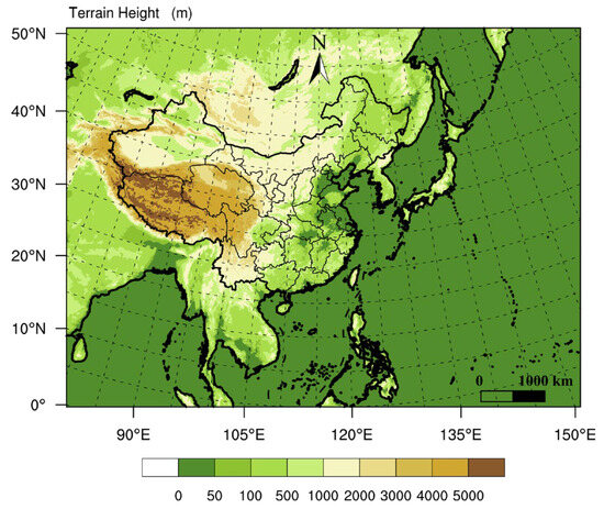
Figure 1.
Horizontal domain of SWARMS-EN.
4. Results
4.1. Ensemble Mean Forecast
Ensemble forecasts of tropical cyclone tracks are typically represented by the ensemble mean. This is the arithmetic average of the TC latitude and longitude among all ensemble members at each time point. Muifa (2022) is selected for analyzing the performance of the ensemble prediction system. The forecast period is from 0000 UTC on 8 September 2022, to 1200 UTC on 14 September 2022. The model makes forecasts twice a day, for a total of 14 forecasts. The real-time TC message data (babj data) from CMA is selected for evaluation, which is also the official TC guide of the CMA. The track forecasts of the ensemble mean by SWARMS-EN, GEFS, and TEDAPS are shown in Figure 2. The red line represents the subjective forecast, while the blue lines are ensemble mean forecasts.

Figure 2.
Track forecast for Muifa. The red line is the subjective forecast from CMA, and the blue lines are ensemble mean forecasts from SWARMS-EN (a), GEFS (b), and TEDAPS (c).
Based on the track forecast for SWARMS-EN, in the early stages of the Muifa, it moves to the northwest. The northerly component of TC will intensify as it approaches the eastern sea of Taiwan Island, and it will progressively move closer to the eastern coast of China. As can be seen from Figure 2a, the turning point predicted by the SWARMS-EN is westward compared to the actual, resulting in a west bias as it moves northward. The GEFS forecast (Figure 2b) is the most accurate before the typhoon changes direction, and the turning point almost matches the actual. However, as the typhoon approaches the southeast coast later on, the track forecasts for GEFS are too slow, leading to a significant forecasting error. The forecast of the TEDAPS is presented in Figure 2c. It is evident that the north-northwestward error of the typhoon, the turning point, and the landfalling forecast are similar to those of the SWARMS-EN. However, it is worth noting that SWARMS-EN has consistently predicted that the typhoon will make landfall on the east coast of China, which is relatively close to the actual.
At the same time, the forecasts from the three ensemble forecast systems were selected for evaluation. The track error of the ensemble forecast is shown in Table 2. It should be noted that the number in parentheses in the first row of the table represents the sample number. The forecast leadtime of TEDAPS is 72 h, while SWARMS-EN and GEFS provide 5-day forecast results. It can be seen that the forecast of GEFS within 24 h has obvious advantages, which is comparable to the level of subjective forecasting (64.5 km/24 h (CMA); 50.4 km/24 h (Shanghai Meteorological Bureau, CMA)), SWARMS-EN slightly outperforms TEDAPS.

Table 2.
Track error of ensemble forecast (homogeneous, unit: km).
The 48-h forecast is similar to the 24-h forecast, and the GEFS forecast remains consistent, with the error growth over 24 h being less than 50 km, reaching 105.1 km. The error growth of SWARMS-EN is comparable to that of GEFS, with a track error of 142.2 km over 48 h, while the error of TEDAPS increases rapidly to 176.0 km within 24 h. In the next 48–72 h, the forecast indicates a different situation compared to the previous one: GEFS shows a slow increasing trend; TEDAPS reached the maximum forecast error at 60 h and then remained around 218 km; the 72-h forecast error of SWARMS-EN decreases instead of increasing, which is lower than the forecast error at 60 h and the forecast error of GEFS during the same period. In the 3-day forecast, SWARMS-EN continues to outperform GEFS, and at later lead times, this advantage becomes more pronounced. In general, the forecast error is 129.1 km for 3 days, 174.5 km for 4 days, and 203.5 km for 5 days. It is superior to subjective and deterministic forecasts, making it the best forecasting method currently available.
Table 3 presents the evaluation of the intensity forecast of the Muifa by the three ensemble forecasting systems. It can be seen that for the daily forecast within three days, SWARMS-EN has the smallest error, 8.2 ms−1 for 24 h, 9.6 ms−1 for 48 h, and 10.5 ms−1 for 72 h, respectively, followed by GEFS with an error of 11.2 ms−1 for 72 h, and TEDAPS has the largest intensity forecast, with a forecast error of 12.0 ms−1 for 72 h. In the forecast after 3 days, the error of GEFS shows a decreasing trend and is only 9.3 ms−1 at 120 h, indicating that the system has a good forecast ability for intensity in the later period. On the contrary, the intensity forecast error of SWARMS-EN gradually increases, and the intensity forecast is inferior to that of GEFS.

Table 3.
Intensity error of ensemble forecast (homogeneous, unit: ms−1).
4.2. RMSE and Ensemble Spread Relationships
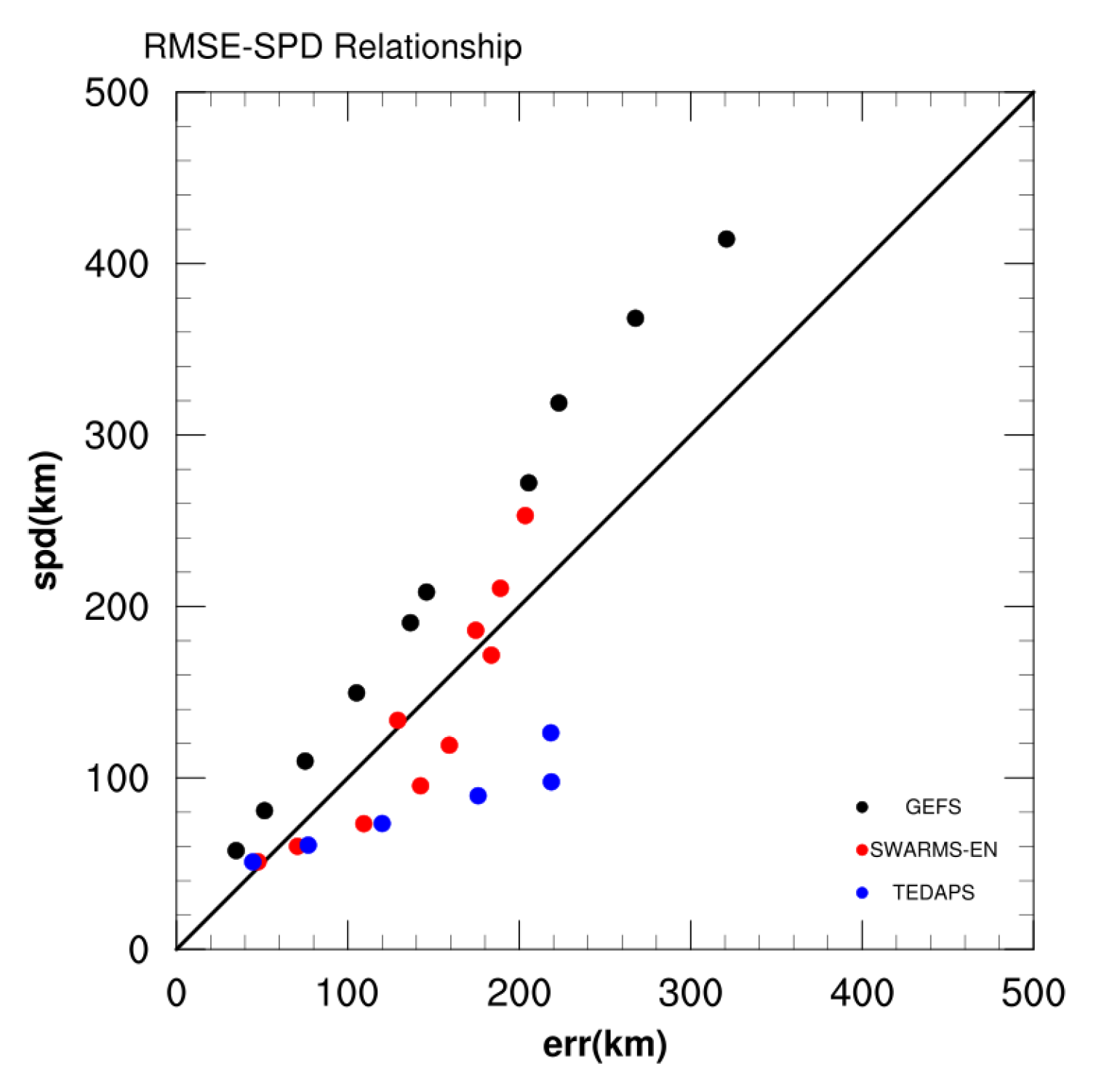
When assessing the reliability of an ensemble prediction system, it is typical to compare the root-mean-square error (RMSE) of the ensemble mean with the ensemble spread. The RMSE and the ensemble spread relationship for three ensemble forecast systems are shown in Figure 3. Blue dots represent TEDAPS, black dots represent GEFS, and red dots represent SWARMS-EN. The x-coordinate represents the RMSE of the track forecast, while the y-coordinate represents the ensemble spread. The ensemble spread also provides a measure of forecast confidence. Forecasts with a larger track spread tend to have a large ensemble-mean track error [25,26,27,28]. Throughout the entire forecast period, the scatter points of GEFS are consistently situated in the upper left corner of the diagonal. This indicates that for the track forecast, the ensemble spread exceeds the forecast error, suggesting that the system is overdispersive. The scatter distribution of TEDAPS shows the opposite shape to GEFS. In other words, the scatter points are all below the diagonal, indicating that the system’s spread is much smaller than the forecast error and that the system is underdispersive. Compared to GEFS and TEDAPS, the scatter points of SWARMS-EN show no obvious systematic bias overall. The ensemble spread within 2 days is less than the RMSE. However, as the forecast lead time increases, the scatter points approach the diagonal, indicating that the system can better represent the forecast uncertainty and provide more reliable forecasts.

Figure 3.
The RMSE ensemble spread distribution of three ensemble systems. Blue dots are TEDAPS, black dots are GEFS, and red dots are SWARMS-EN.
4.3. Landfall Forecast
Muifa (2022) was the third TC to make landfall four times since 1949 in China, after Yancy (1990) and Fung-wong (2014). It successively made landfall in Zhoushan, Zhejiang province; Shanghai; Qingdao, Shandong province; and Dalian, Liaoning province. The forecast for the first landing was particularly crucial as it was the first step in its lifespan from the ocean to the land, and its impact was much greater than that of the subsequent three landfalls. The following focuses on the analysis of the first landfall.
The CMA subjective forecast did not show any indications of a typhoon making landfall before 0200 UTC on 10 September 2022 for the whole forecasting process. Wang et al., (2023) found two significant track errors in the CMA forecast of Muifa, one of which was the mid- to long-term (3–5 days) forecast during the early stage of TC formation, and the other was the track forecast over land for Muifa, which was slower and westward compared with the observation. This paper mainly discusses the forecast of TC landfall, which is closely associated with the first point. Due to the increasing differences among various NWP forecasts, the spread between the ensemble members is also large, indicating a high level of uncertainty in the 3–5 day track forecast. That makes it challenging for forecasters to draw a conclusion on the likelihood of landfall.
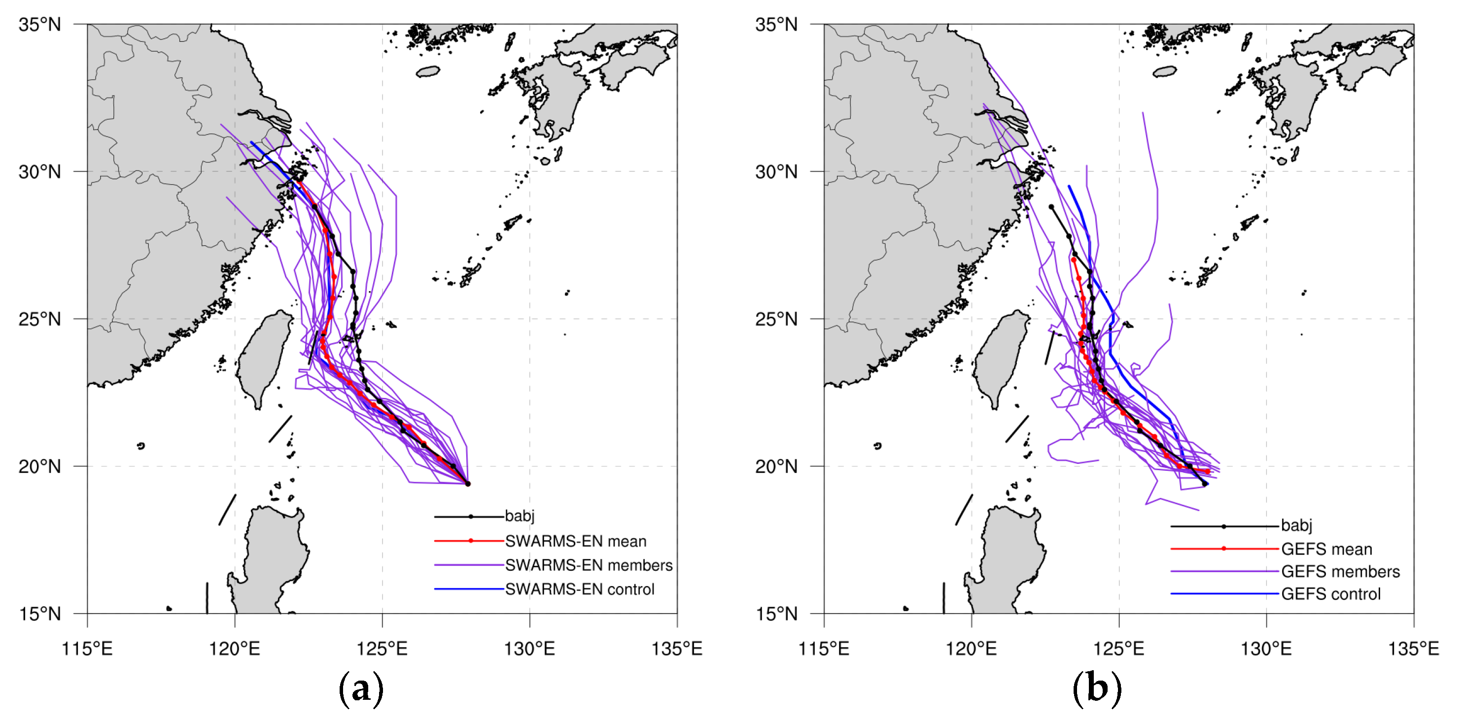
Figure 4a shows the track forecast for SWARMS-EN from 12 UTC on 9 September. The blue line is the deterministic forecast, the red line is the ensemble mean, the black dotted line is the best track, and the purple lines are forecasts from ensemble members. In the process of TC recurving, the differences among the members are mainly reflected in the longitude, which ranges from 122° E to 124° E, but there is little difference in the latitude. In general, all track forecasts are to the west and south relative to the best track. For the landfalling forecast, it is evident that nearly all the members have predicted that the typhoon will likely approach the coast of Zhejiang and have a high probability of making landfall. The track error of the ensemble mean for the 120-h forecast is only 28.4 km, which represents a significant improvement compared to the 206.6 km of the deterministic forecast. This is the probability forecast information for 5 days in advance provided by the ensemble forecast. It differs significantly from the subjective forecast and serves as a reference for the subsequent forecast of the tropical cyclone movement. This information is worthy of continuous attention by forecasters.
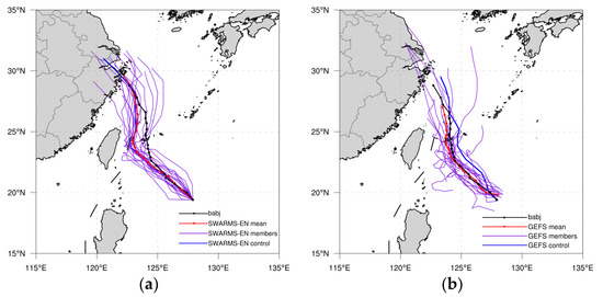
Figure 4.
Track forecast of Muifa from SWARMS-EN (a) and GEFS (b) on 1200 UTC 9 September 2022.
Comparing the GEFS with the SWARMS-EN for the landfalling forecast at the same time (Figure 4b). It can be seen that the forecast difference among GEFS members is larger than that of SWARMS-EN members. There are two different scenarios for the TC track. One is that TC moves slowly northward in the eastern part of Taiwan Island, which is similar to the subjective prediction of CMA. The other scenario is that Muifa continued to move northwest through the eastern part of Taiwan Island, approached the East China coast, and made landfall in Zhejiang, which aligns with the forecast of SWARMS-EN. The divergence in forecast can be clearly seen from the ensemble mean forecast of the two systems.
4.4. Ensemble-Based Analysis
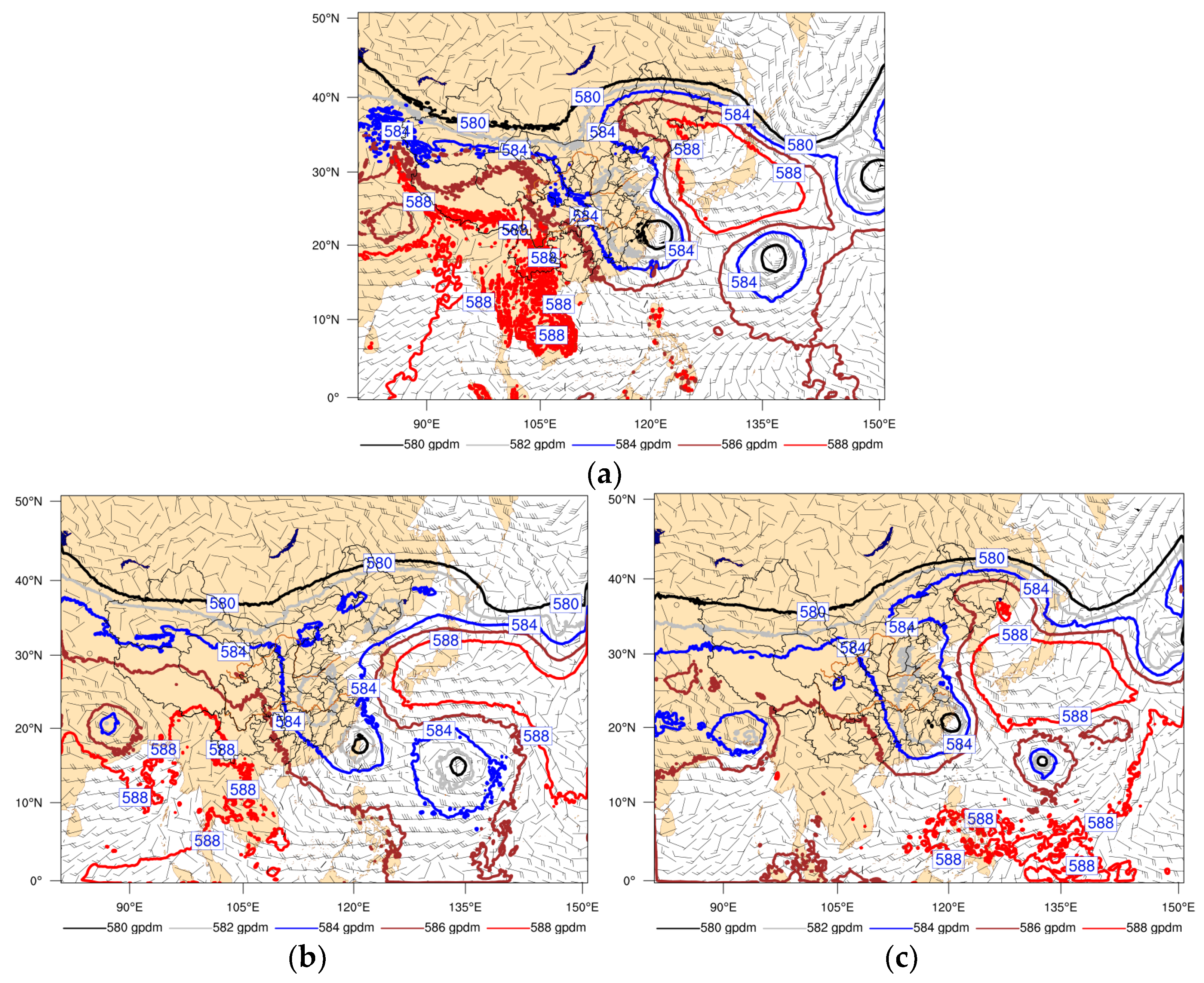
The landfalling forecasts for TC are described in Section 4.3. It is evident that SWARMS-EN provides a more accurate landfall forecast five days in advance. However, a careful analysis of the tracks among members shows that there are still significant differences between them. In this case, members 7 and 20 exhibit typical bifurcation. The track of member 7 is closer to the mean forecast of GEFS, exhibiting a northwest trajectory in the early stages that is similar to the observation. However, the turning point is slightly to the west of the observation. After the typhoon changed direction, it slowly moved northward while maintaining its strength, but there is no indication of it making landfall. While the track of member 20 is closer to the mean forecast of SWARMS-EN, the early track is similar to that of the GEFS, but the turning point is significantly to the west. After the TC recurvature, its northward component rapidly increased and moved to East China. The differences between the two members are so significant that they need to be analyzed in terms of large-scale environmental fields, as shown in Figure 5. The figure displays the geopotential height of 500 hPa and the wind field of 850 hPa at 6 h before landfall. Several major systems are influencing the track of TC, including the subtropical high, TC Nanmadol (2022), and the low-pressure system over land.
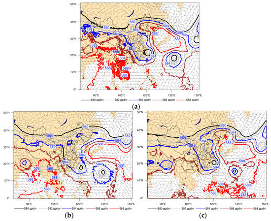
Figure 5.
Geopotential height at 500 hPa and wind field at 850 hPa at 0600 UTC 14 September 2022. ((a): analysis field, (b): member 7, (c): member 20).
Compared with the analysis filed, the circulation field of East Asia by member 7 is generally weak. On one hand, the intensity of the subtropical high over East Asia was relatively weak. The northern boundary of 588 gpdm only extended to the western region of Japan, but in fact, it had already reached northeastern China. On the other hand, the low-pressure system in central and eastern China exhibited lower intensity. This led to Muifa and Nanmadol being located within the same low-pressure circulation, forming a dual typhoon system. Consequently, Muifa gradually developed a southward component as its northward speed progressively slowed down or even stalled, ultimately leading to an unsuccessful forecast. Among all the predictions of members, Member 20 accurately depicted the overall characteristics of East Asian circulation patterns by indicating that the subtropical high was stronger over Japan and its northern boundary extended into northeast China. Additionally, it correctly identified that the southern boundary of the low-pressure circulation in central and eastern China lay near the southeastern coastlines, clearly distinguishing it from the circulation field of Nanmadol. These specific atmospheric conditions were favorable for Muifa’s northward movement along the western edge of Japan’s subtropical high after making landfall.
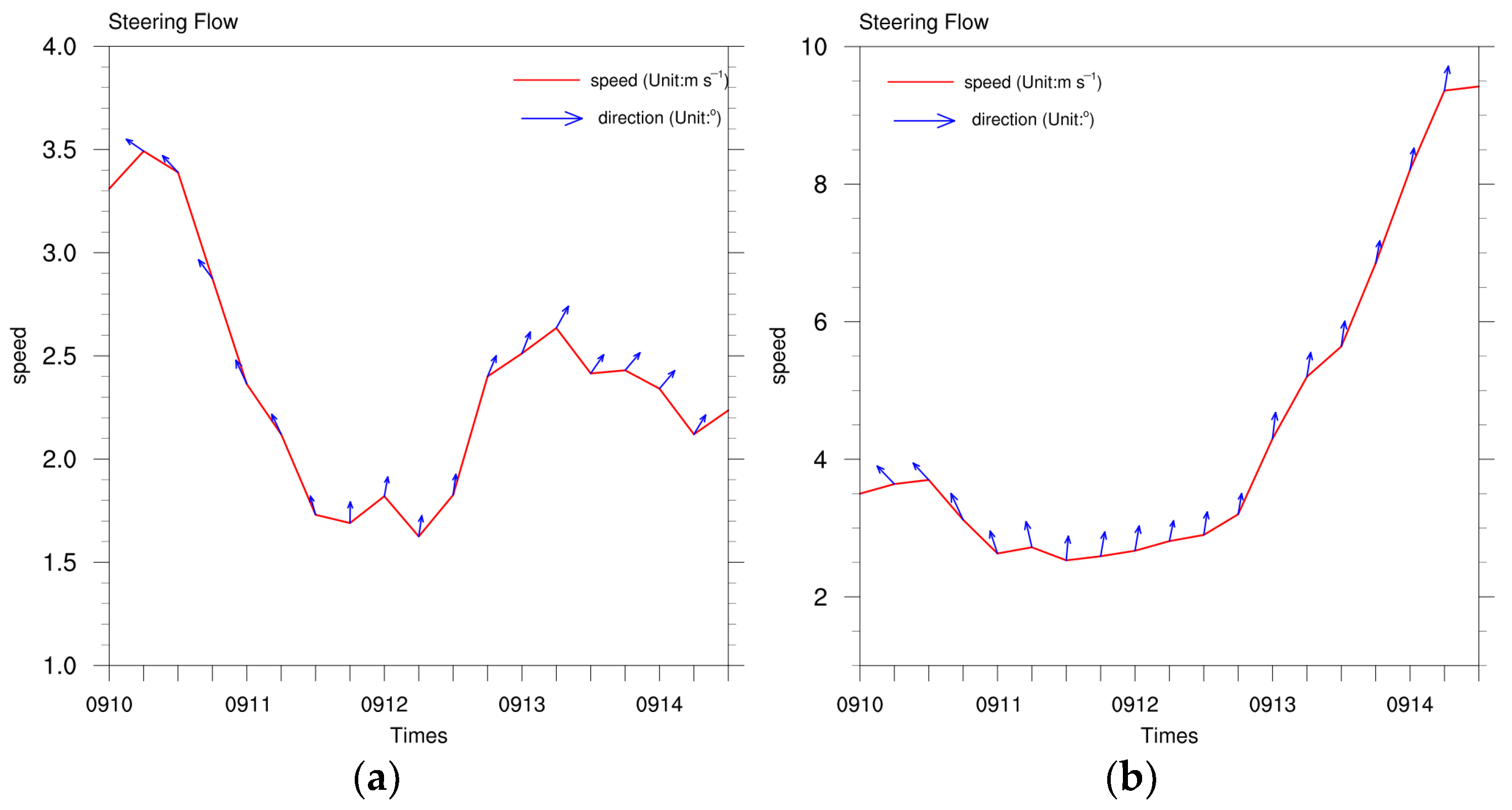
As can be seen from the above analysis, the primary factors influencing the track of Muifa are the subtropical high and its associated large-scale circulation field. To describe the changes in the steering flow around TC, a whole layer wind of 200–850 hPa is calculated. Figure 6 shows a time series diagram of the steering flow for two members. The azimuth angle of the blue arrow in the figure indicates the direction of the steering flow, and the vertical axis indicates the magnitude of the steering flow, reflecting the difference in the flow field between the two members. From the perspective of the direction of the steering flow, there is little difference between the two members, and both of them change direction from northwest to northeast or north-northeast at 1112 UTC. However, there are significant differences in the magnitude of the steering flow between them. The steering flow of member 7 shows a notable decreasing trend. The magnitude of the steering flow is 1.75 ms−1, and the oscillation increases to 2.62 ms−1 at 1306 UTC and then gradually decreases. During the entire forecasting process, the range of the steering flow is between 1.54 and 3.5. For member 20, before 1112 UTC, the magnitude of the steering flow gradually decreased from 3.5 ms−1 to 2.43 ms−1. However, after the turn, the steering flow exhibited a monotonically increasing trend, and the magnitude sharply increased from 2.43 ms−1 to 9.32 ms−1. It can be seen that the weak environmental steering flow causes Muifa to move slowly, and on the contrary, it releases a strong landfalling signal.
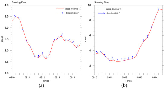
Figure 6.
Time series diagram of steering flow. ((a): member 7, (b): member 20).
4.5. Characterization of the Initial Perturbation
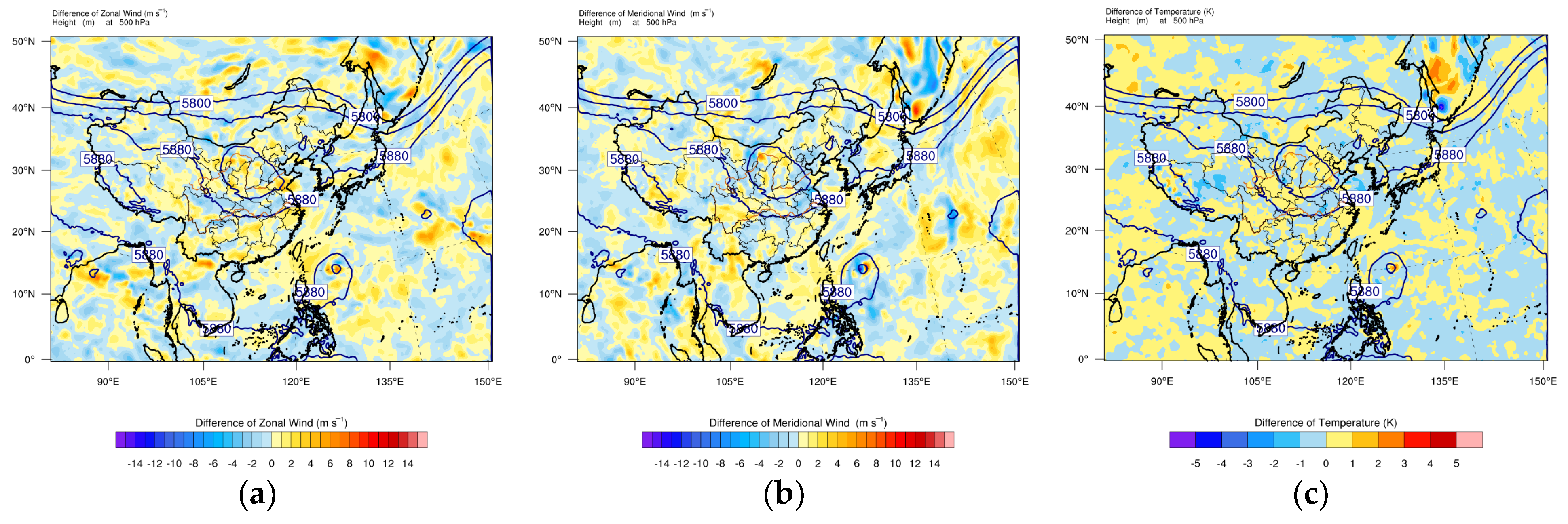
It can be seen from the previous analysis that there is a significant difference between member 7 and member 20 in the track forecast. Is there a significant difference in the initial time? The wind and temperature perturbations at 500 hPa were used to analyze the differences in variables (see Figure 7 and Figure 8). It can be seen that the distribution of geopotential height between two members is similar, but the wind and temperature perturbations are clearly different. Taking zonal wind as an example, from a horizontal perspective, positive and negative disturbances alternate in the pattern of the perturbation. In the region where the contour is relatively flat, known as the dynamic stable area, perturbation is evenly distributed among the members and the magnitude is small. On the contrary, in dynamically unstable areas such as TC and the upper trough area, the perturbation value between members increases significantly. This also reflects that perturbation at 500 hPa is clearly flow-dependent. Specifically, the perturbation value range for member 7 is from −8.35 ms−1 to 8.13 ms−1, while for member 20 it is from −6.86 ms−1 to 16.90 ms−1. The positive perturbation is particularly pronounced near TC, representing the most significant difference between the two members. The same is true for meridional wind perturbations and temperature perturbations; differences between members are more pronounced in areas of dynamic instability, especially near TC.
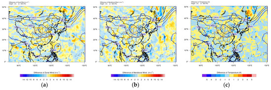
Figure 7.
Perturbation variables are at 500 hPa at the initial time for member 7, and the black contour is the geopotential height. ((a): zonal wind (Unit: ms−1), (b): meridional wind (Unit: ms−1), (c): temperature (Unit: K)).

Figure 8.
Perturbation variables are at 500 hPa at the initial time for member 20, and the black contour is the geopotential height. ((a): zonal wind (Unit: ms−1), (b): meridional wind (Unit: ms−1), (c): temperature (Unit: K)).
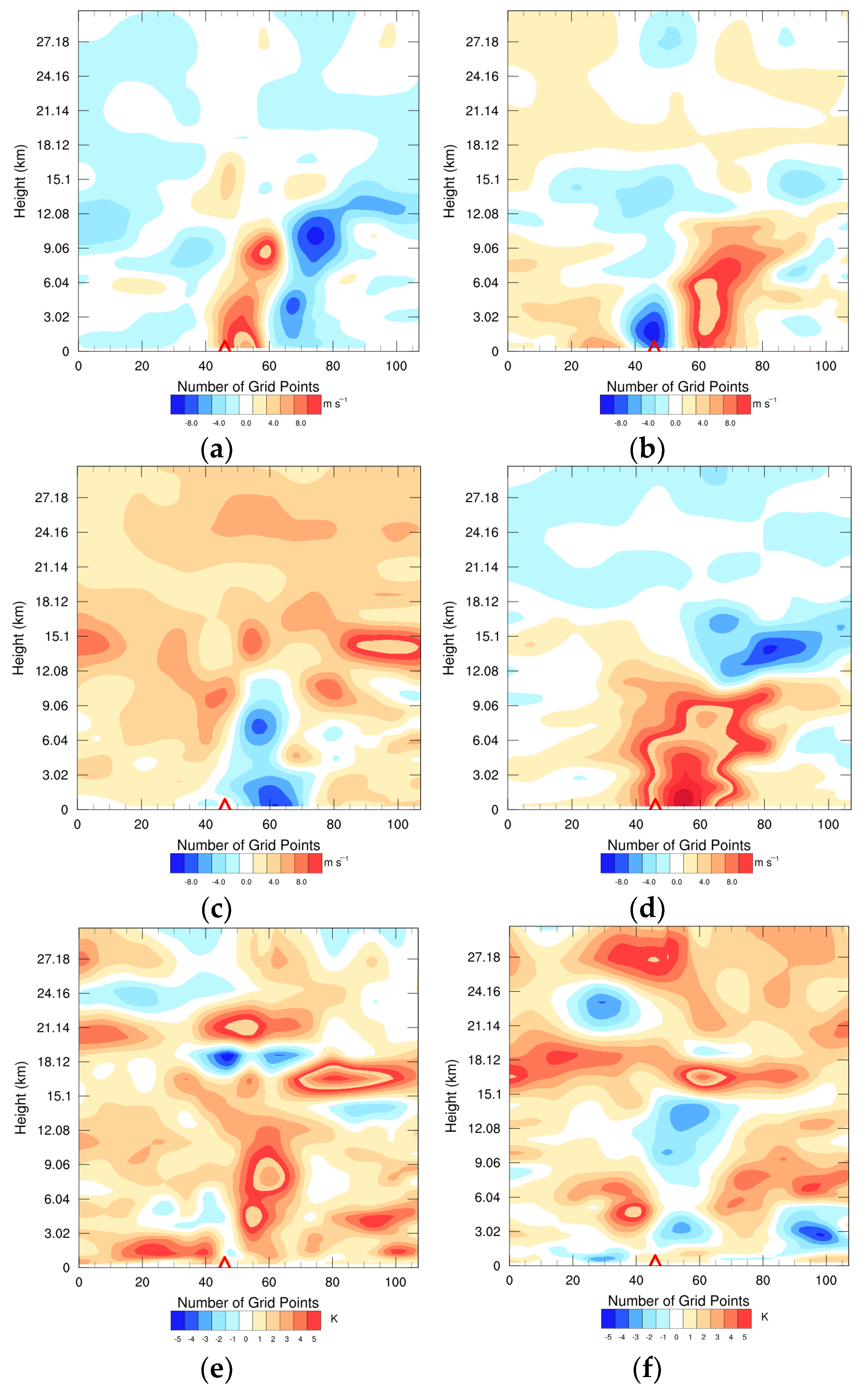
The above analysis reveals that there are significant differences among the members near the TC at the initial time. The TC is located at 127.9° E and 19.4° N. An area with a radius of 5 degrees has been selected for further analysis of the vertical structural characteristics of the aforementioned variables. In this paper, the north-south section is used as an example (Figure 9). The perturbation of the zonal wind reveals that the large amplitude of the perturbation is concentrated near the TC, and the overall altitude is below 10–12 km (approximately 200 hPa). The characteristics of positive and negative disturbances around the typhoon center are evident. The disturbance of member 7 is slightly north of the typhoon center, displaying two significant value areas in vertical distribution. One is located in the middle and lower troposphere at 3 km, and the other is located in the upper troposphere at 9 km. The distribution of disturbance for member 20 is closer to the center of the typhoon in the horizontal position. In the vertical structure, there is a continuous large area of positive and negative association in the middle and lower tropospheres, and the positive disturbance extends to the upper troposphere.

Figure 9.
Vertical distribution of zonal wind perturbation, meridional wind perturbation, and temperature perturbation at 1200 UTC on 9 September 2022. (a,c,e) member 7; (b,d,f) member 20.
In the TC region of the troposphere, the vertical development of the meridional wind perturbation differs from the zonal wind. It is characterized by positive or negative disturbances, rather than a combination of both. Member 7 primarily represents a negative disturbance, while member 20 primarily represents a positive disturbance. Similar to zonal wind, in terms of vertical structure, the maximum value is observed near the top of the troposphere at 12 km, and perturbation values are relatively uniform in the stratosphere with a significant reduction.
In addition to the differences in the troposphere near TC, the temperature perturbations also exhibit significant variations in the stratosphere among the members. Since the influence of the TC does not extend to the stratosphere, the differences in such perturbations generally occur over a wide range of the stratosphere (for example, near an altitude of 18 km), which also indicates the large uncertainty of the model in stratosphere forecast.
4.6. The Evolution of Perturbation Energy
Generally, the distribution characteristics of perturbation energy can be used to assess the rationality of the initial perturbation structure. A reasonable initial perturbation can capture the rapidly growing error in the initial field and represent areas with large uncertainties. Meanwhile, a reasonable initial perturbation should exhibit a reasonable increase with the extension of the forecast time in order to accurately reflect the objective relationship between forecast error and forecast lead time. In this paper, the total perturbation energy proposed by Palmer [29] is used for analysis. The formula is as follows:
u′, v′, T′ is the perturbation of zonal wind, meridian wind, and temperature, respectively. Perturbation is defined as the difference between the control run and ensemble members. Cp is the constant pressure-specific heat of dry air, Tr is the reference temperature, and i, j, and k are the horizontal and vertical grid points of the model area, respectively.
Figure 10 shows the vertical distribution profiles of the average perturbation of kinetic energy, internal energy, and total energy for member 7 and member 20 for the 120 h forecast. The graphic illustrates the development of perturbated total energy, internal energy, and kinetic energy with forecast lead time, reflecting the characteristic of model forecast error increasing with the forecast lead time to some extent. Using member 7 as an example, the predicted perturbation of kinetic energy at 200 hPa is 2.65 J kg−1 at the initial time, and it increases to 42.93 J kg−1 after five days. The initial perturbation of internal energy increases from 0.62 J kg−1 to 7.16 J kg−1 after 5 days. The perturbation of total energy increases from 3.27 J kg−1 to 50.09 J kg−1, and the energy increases by more than 15 times. In general, the contribution of kinetic energy to total energy is greater than that of internal energy, regardless of the magnitude or rate of disturbance growth. It is also noted that there are differences in the vertical distribution of disturbance energy performance: the influence area of the disturbance energy is mainly in the upper troposphere, and the area with large values is located near 200 hPa, close to the jet stream axis. This finding is consistent with the research results of Bowler et al. [30]. In addition to the upper level, the internal energy of the disturbance also affects the lower troposphere, specifically around 850 hPa to 925 hPa. This may be associated with the low-level jet stream and thermal changes induced by radiation. As can be seen from the total energy of the disturbance, the total energy of the disturbance is mainly kinetic energy. After 3 days of forecasting, the disturbance is easier to develop in the upper troposphere, forming an obvious large area, followed by the middle and lower tropospheres, and the disturbance in the middle troposphere and the near-surface layer is relatively small. On the other hand, the disturbance at the upper level is easier to develop, and it will be relatively difficult to increase the spread of the variables at the bottom of the atmosphere.


Figure 10.
Vertical distributions of perturbed kinetic energy, internal energy, and total energy (units: J kg−1) from 0000 UTC 11 September 2022 to 1200 UTC 15 September 2022: (a–c): member 7; (d–f): member 20.
By comparing the differences between the two members, it can be seen that the perturbation between the two members is not significant initially. However, as the forecasting time increases, the difference between the two gradually becomes apparent. The change in internal energy is relatively minor, with member 7 exhibiting a faster development rate than member 20, and the overall amplitude remaining consistent. In contrast, there are significant changes in kinetic energy, particularly in the upper troposphere after 3 days. Member 7 exhibits a disturbance kinetic energy of nearly 30 J kg−1 at 200 hPa for 96 h and 45 J kg−1 after 5 days, whereas Member 20 develops relatively slowly, reaching only 28 J kg−1 after 5 days. The comparison of the total disturbance energy shows that the primary difference between the two is concentrated in the upper troposphere, around 200 hPa. This observation also indicates that the total disturbance energy is predominantly kinetic energy.
5. Summary and Discussion
By considering the uncertainties in the initial field, model physical processes, and lateral boundary conditions, the Shanghai Weather And Risk Model System-Ensemble Prediction System (SWARMS-EN) has been developed. The prediction results for Muifa (2022) indicated that the daily track errors of SWARMS-EN within 5 days were 70.6 km, 142.2 km, 129.1 km, 174.5 km, and 203.5 km, respectively. When compared to the same samples of TEDAPS and GEFS in operation, the forecast of SWARMS-EN was better than TEDAPS within 72 h and better than GEFS after 72 h. This indicates an improvement in forecast accuracy.
The analysis of ensemble spread indicates that SWARMS-EN exhibits no apparent systematic bias overall. The ensemble spread within 2 days is less than the RMSE, indicating a better RMSE-spread relationship. This suggests that the system can better represent the uncertainty of the forecast and provide more reliable forecasts.
SWARMS-EN provides accurate typhoon landfall information five days in advance. The ensemble-based analysis reveals that the difference in the large-scale circulation fields is the primary factor contributing to the difference in forecast accuracy among the members, with particular emphasis on the magnitude of the steering flow.
The analysis of the ensemble characteristics of the initial field indicates that the initial perturbation between the wind field and the temperature field in the dynamically unstable region (such as near TC) exhibits flow dependence, and the small perturbation exhibits continuity throughout the entire troposphere. With the extension of the forecast lead time, the distribution of ensemble spread and perturbed energy showed a reasonable development. The lower troposphere was primarily influenced by perturbations in internal energy, while the upper troposphere was mainly characterized by perturbations in kinetic energy. Perturbed kinetic energy played a leading role in the evolution process. This conclusion further confirms the importance of paying attention to the initial small perturbations near the TC, which also supports the next step of ensemble perturbation optimization.
Author Contributions
Conceptualization, Y.T. and W.H.; methodology, Y.T.; software, Y.T. and W.H.; validation, Y.T. and X.Z.; formal analysis, Y.T.; investigation, Y.T.; resources, Y.T.; data curation, X.Z.; writing—original draft preparation, Y.T.; writing—review and editing, Y.T. and W.H.; visualization, Y.T.; supervision, W.H.; project administration, Y.T.; funding acquisition, Y.T. All authors have read and agreed to the published version of the manuscript.
Funding
This research was funded by the National Key Research and Development Program of China (2021YFC3000802).
Institutional Review Board Statement
Not applicable.
Informed Consent Statement
Not applicable.
Data Availability Statement
The data of GEFS is available at https://rda.ucar.edu/datasets/ds330.3/ (accessed on 6 March 2024) from National Center for Atmospheric Research. The data of babj, SWARMS-EN and TEDAPS in this study are available on request from the corresponding author due to privacy.
Conflicts of Interest
The authors declare no conflicts of interest.
References
- Xu, Y.L.; Zhang, L.; Gao, S.Z. The advances and discussions on China operational typhoon forecasting. Meteor. Mon. 2010, 36, 43–49. [Google Scholar]
- Lei, X.T.; Chen, P.Y.; Yang, Y.H.; Qian, Y.Z. Characters and objective assessment of disasters caused by typhoon in China. Acta Meteorol. Sin. 2009, 67, 875–883. [Google Scholar] [CrossRef]
- Liu, K.S.; Chan, J.C.L. Growing threat of rapidly-intensifying tropical cyclones in East Asia. Adv. Atmos. Sci. 2022, 39, 222–234. [Google Scholar] [CrossRef]
- Marks, F.D.; Shay, L.K.; Barnes, G.; Black, P.; Demaria, M.; McCaul, B.; Mounari, J.; Montgomery, M.; Powell, M.; Smith, J.D.; et al. Landfalling Tropical Cyclones: Forecast Problems and Associated Research Opportunities. Bull. Am. Meteorol. Soc. 1998, 79, 305–323. [Google Scholar]
- Duan, Y.H.; Chen, L.S.; Liang, J.Y.; Wang, Y.; Wu, L.G.; Cui, X.P.; Ma, L.M.; Li, Q.Q. Research progress in the unusual variations of typhoons before and after landfalling. Acta Meteorol. Sin. 2014, 72, 969–986. [Google Scholar] [CrossRef]
- Leroux, M.D.; Wood, K.; Elsberry, R.L.; Cayanan, E.O.; Hendricks, E.; Kucas, M.; Otto, P.; Rogers, R.; Sampson, B.; Yu, Z.F. Recent advances in research and forecasting of tropical cyclone track, intensity, and structure at landfall. Trop. Cyclone Res. Rev. 2018, 7, 85–105. [Google Scholar] [CrossRef]
- Duan, Y.; Wan, Q.; Huang, J.; Zhao, K.; Yu, H.; Wang, Y.; Zhao, D.; Feng, J.; Tang, J.; Chen, P.; et al. Landfalling Tropical Cyclone Research Project (LTCRP) in China. Bull. Am. Meteor. Soc. 2019, 100, 447–472. [Google Scholar] [CrossRef]
- Lei, X. Overview of the development history of China’s typhoon research and operational work in the past century. Sci. China Earth Sci. 2020, 63, 362–383. [Google Scholar] [CrossRef]
- Wu, Y.; Chen, P.Y.; Lei, X.T. A preliminary study on the benefit assessment of track and intensity forecast of landfall tropical cyclones. J. Trop. Meteorol. 2017, 33, 675–682. [Google Scholar] [CrossRef]
- Landsea, C.W.; Cangialosi, J.P. Have we reached the limits of predictability for tropical cyclone track forecasting? Bull. Am. Meteor. Soc. 2018, 99, 2237–2243. [Google Scholar] [CrossRef]
- Yu, H.; Chen, G.M.; Zhou, C.; Wong, W.K.; Yang, M.Q.; Chen, P.Y.; Wan, R.J.; Hu, X.R. Are We Reaching the Limit of Tropical Cyclone Track Predictability in the Western North Pacific? Bull. Am. Meteor. Soc. 2022, 103, 410–428. [Google Scholar] [CrossRef]
- Rappaport, E.N.; James, L.F.; Lixion, A.A.; Stephen, R.B.; Beven, J.L., II; Blake, E.S.; Burr, C.A.; Jiing, J.-G.; Juckins, C.A.; Knabb, R.D.; et al. Advances and challenges at the National Hurricane Center. Weather Forecast. 2009, 24, 395–419. [Google Scholar] [CrossRef]
- Torn, R.D.; Hakim, G.J. Ensemble-based sensitivity analysis. Mon. Weather Rev. 2008, 136, 663–677. [Google Scholar] [CrossRef]
- Torn, R.D.; Hakim, G.J. Initial condition sensitivity of western Pacific extratropical transitions determined using ensemble-based sensitivity analysis. Mon. Weather Rev. 2009, 137, 3388–3406. [Google Scholar] [CrossRef]
- Torn, R.D.; DeMaria, M. Validation of Ensemble-Based Probabilistic Tropical Cyclone Intensity Change. Atmosphere 2021, 12, 373. [Google Scholar] [CrossRef]
- Melhauser, C.; Zhang, F.Q.; Weng, Y.H.; Jin, Y.; Zhao, Q.Y. A multiple-model convection-permitting ensemble examination of the probabilistic prediction of tropical cyclones: Hurricanes Sandy (2012) and Edouard (2014). Weather Forecast. 2017, 32, 665–688. [Google Scholar] [CrossRef]
- Nystrom, R.G.; Zhang, F.Q.; Munsell, E.B.; Braun, S.B.; Sipper, J.A.; Weng, Y.H.; Emanuel, K. Predictability and Dynamics of Hurricane Joaquin (2015) Explored through Convection-Permitting Ensemble Sensitivity Experiments. J. Atmos. Sci. 2018, 75, 401–424. [Google Scholar] [CrossRef]
- Liu, D.; Xu, Y.L. Analysis of the September 2022 Atmospheric Circulation and Weather. Meteor. Mon. 2022, 48, 1629–1636. [Google Scholar] [CrossRef]
- Wang, Q.; Qian, C.H.; Dong, L.; Xiang, C.Y.; Xu, Y.L.; Zhang, L.; Li, X. Analysis on main characteristics of Typhoon Muifa (2022) and difficulties in its track forecast. J. Mar. Meteor. 2023, 43, 52–62. [Google Scholar]
- Li, H.; Luo, J.Y.; Xu, M.T. Ensemble data assimilation and prediction of typhoon and associated hazards using TEDAPS: Evaluation for 2015–2018 seasons. Front. Earth Sci. 2019, 13, 733–743. [Google Scholar] [CrossRef]
- Zhou, X.Q.; Zhu, Y.J.; Hou, D.C.; Luo, Y.; Peng, J.Y.; Wobus, R. Performance of new NCEP global forecast system in a parallel experiment global forecast system in a parallel experiment. Weather Forecast. 2017, 32, 1989–2004. [Google Scholar] [CrossRef]
- Tan, Y.; Huang, W.; Yang, Y.H.; Zhang, X.; Chen, B.D. Improvement in the Mesoscale Ensemble Forecast Sytem in East China and A Precipitation Experiment in the 2020 Meiyu Season. Chin. J. Atmos. Sci. 2022, 46, 1437–1453. [Google Scholar]
- Berner, J.; Fossell, K.R.; Ha, S.-Y.; Hacker, J.P.; Snyder, C. Increasing the skill of probabilistic forecasts: Understanding performance improvements from model-error representations. Mon. Weather Rev. 2015, 143, 1295–1320. [Google Scholar] [CrossRef]
- Zhang, X.; Yang, Y.H.; Chen, B.D.; Huang, W. Operational precipitation forecast over China using the weather research and forecasting (WRF) model at a gray-zone resolution: Impact of convection parameterization. Weather Forecast. 2021, 36, 915–928. [Google Scholar] [CrossRef]
- Yamaguchi, M.; Sakai, R.; Kyoda, M.; Komori, T.; Kadowaki, T. Typhoon ensemble prediction system developed at the Japan Meteorological Agency. Mon. Weather Rev. 2009, 137, 2592–2604. [Google Scholar] [CrossRef]
- Yamaguchi, M.; Ishida, J.; Sato, H.; Nakagawa, M. WGNE Intercomparison of Tropical Cyclone Forecasts by Operational NWP Models: A Quarter Century and Beyond. Bull. Am. Meteor. Soc. 2017, 98, 2337–2349. [Google Scholar] [CrossRef]
- Majumdar, S.J.; Finocchio, P.M. On the ability of global ensemble prediction systems to predict tropical cyclone track probabilities. Weather Forecast. 2010, 25, 659–680. [Google Scholar] [CrossRef]
- Zhang, X.P.; Yu, H. A probabilistic tropical cyclone track forecast scheme based on the selective consensus of ensemble prediction systems. Weather Forecast. 2017, 32, 2143–2157. [Google Scholar] [CrossRef]
- Palmer, T.N.; Gelaro, R.; Barkmeijer, J.; Buizza, R. Singular vectors, metrics, and adaptive observations. J. Atmos. Sci. 1998, 55, 633–653. [Google Scholar] [CrossRef]
- Bowler, N.E.; Arribas, A.; Mylne, K.R.; Robertson, K.B.; Beare, S.E. The MOGREPS short-range ensemble prediction system. Q. J. R. Meteorol. Soc. 2008, 134, 703–722. [Google Scholar] [CrossRef]
Disclaimer/Publisher’s Note: The statements, opinions and data contained in all publications are solely those of the individual author(s) and contributor(s) and not of MDPI and/or the editor(s). MDPI and/or the editor(s) disclaim responsibility for any injury to people or property resulting from any ideas, methods, instructions or products referred to in the content. |
© 2024 by the authors. Licensee MDPI, Basel, Switzerland. This article is an open access article distributed under the terms and conditions of the Creative Commons Attribution (CC BY) license (https://creativecommons.org/licenses/by/4.0/).


