Article

Modeling of Air Quality near Indian Informal Settlements Where Limited Local Monitoring Data Exist

by
Ryan W. Hirst
1,2,
Myra J. Giesen
1,3,
Maria-Valasia Peppa
1,
Kelly Jobling
1,
Dnyaneshwari Jadhav
1,
S. Ziauddin Ahammad
4,
Anil Namdeo
5 and
David W. Graham
1,6,*
1
School of Engineering, Newcastle University, Newcastle upon Tyne NE1 7RU, UK
2
Cundall, Partnership House, Newcastle upon Tyne NE3 3AF, UK
3
School of Education, Communication and Language Sciences, Newcastle University, Newcastle upon Tyne NE1 7RU, UK
4
Department of Biochemical Engineering and Biotechnology, Indian Institute of Technology Delhi, Hauz Khas, New Delhi 110016, India
5
Department of Geography and Environmental Sciences, Northumbria University, Newcastle upon Tyne NE1 8ST, UK
6
Department of Biosciences, Durham University, Durham DH1 3LE, UK
*
Author to whom correspondence should be addressed.
Atmosphere 2024, 15(9), 1072; https://doi.org/10.3390/atmos15091072
Submission received: 29 July 2024 / Revised: 2 September 2024 / Accepted: 3 September 2024 / Published: 5 September 2024
(This article belongs to the Special Issue Urban Air Pollution Exposure and Health Vulnerability)

Abstract

:
The world is becoming increasingly urbanized, with migration rates often exceeding the infra-structural capacity in cities across the developing world. As such, many migrants must reside in informal settlements that lack civil and health protection infrastructure, including air quality monitoring. Here, geospatial inverse distance weighting and archived Central Pollution Control Board (CPCB) air quality data for neighboring stations from 2018 to 2021 were used to estimate air conditions in five informal settlements in Delhi, India, spanning the 2020 pandemic lockdown. The results showed that WHO limits for PM2.5 and NO2 were exceeded regularly, although air quality improved during the pandemic. Air quality was always better during the monsoon season (44.3 ± 3.47 and 26.9 ± 2.35 μg/m3 for PM2.5 and NO2, respectively) and poorest in the post-monsoon season (180 ± 15.5 and 55.2 ± 3.59 μg/m3 for PM2.5 and NO2). Differences in air quality among settlements were explained by the proximity to major roads and places of open burning, with NO2 levels often being greater near roads and PM2.5 levels being elevated near places with open burning. Field monitoring was performed in 2023 at three settlements and local CPCB stations. Air quality at settlements and their closest station were not significantly different (p < 0.01). However, field data showed that on-site factors within settlements, such as cooking, ad hoc burning, or micro-scale industry, impact air quality on local scales, suggesting health risks are greater in informal settlements because of greater unregulated activity. City-scale models can estimate mean air quality concentrations at unmonitored locations, but caution is needed because such models can miss local exposures that may have the greatest impact on local health.

Graphical Abstract

1. Introduction

The global trend of urbanization is undeniable, and a transition from rural to urban living is occurring at a steady and increasing pace [1,2]. This shift in urbanization is particularly notable in low-to-middle-income countries in the Global South [3]. For example, approximately one-third of India’s population in 2021 resided in urban areas—a four percent rise in urbanization over the past decade [4], as individuals seek greater employment opportunities in urban centers [3]. However, city planning often falls short of needs, resulting in inadequate civil infrastructure for migrants, including poor roads, housing, and water, sanitation, and hygiene (WASH) capacity. Since 2005, around 43,000 dwellings have been built for the poor in Delhi, and yet, the population increased by over 10 million over the same period [5]. Consequently, many migrants reside in unregulated, densely populated informal settlements with little environmental protection.
Such informal settlements typically have inadequate sanitation, ad hoc physical infrastructure, high population densities, and irregular land tenure [6]. Such conditions increase the potential for health problems, often because of inadequate WASH [7], resulting in communicable diseases spread through contaminated water and food [8]. However, residents also can be exposed to elevated air pollutants, such as PM2.5 particles (particles in air < 2.5 µm diameter), which contribute to cardiovascular and respiratory disease [9]. Increased exposure to PM2.5 has led to increased mortality in Indian cities, including Delhi [10]. Air pollutant exposures and inadequate WASH increase the risk of disease in informal settlement dwellers, as observed during the COVID-19 pandemic [11,12].
Gathering local environmental data is key to assessing exposure risks to pollutants affecting human health. Yet, informal settlements often lack official recognition, are frequently “off the grid” for monitoring, and have less regulated behavior, making health studies challenging. Further, such settlements tend to be physically and socially dynamic, often rendering past data obsolete. To address these gaps, alternate ways of estimating environmental quality are needed for health protection in informal settlements. For example, spatial interpolation of publicly available data may be used to predict mean air quality in places where local monitoring stations are not present. Specifically, Geographic Information System (GIS)-based approaches can interpolate existing air quality data to create “exposure risk maps” to guide interventions to improve health and quality of life.
Spatial interpolation, used in GISs, is a well-established method for extending data to unknown locations [13,14]. Predicting air quality over large regions often involves extrapolating point data from monitoring stations to regional scales [15]. For example, Amann et al. [16] and Nidhi and Jayaraman [17] assessed air pollution across Delhi using air quality data from Continuous Ambient Air Quality Monitoring Stations (CAAQMSs). Adhikary et al. [18] and Bidhuri and Khan [19] employed spatial interpolation models to estimate groundwater quality in western and central/southeastern Delhi, respectively. Nevertheless, no previous studies have specifically focused on informal settlements, which are dynamic over time and space, especially on very local scales.
Here, a low-cost and straightforward spatial interpolation method, inverse distance weighting (IDW), was used to estimate air quality in five informal settlements in Delhi. Originally, it was planned to combine modeling with field measurements. However, because of COVID-19 lockdowns during the pandemic, fieldwork was not possible. As a result, publicly available air quality data were used from the Government of India’s Central Pollution Control Board (CPCB) to model conditions from 2018 to 2021, which was followed up with field sampling in 2023. IDW was used rather than machine learning or convolution neural networks because of inadequate available data for training more advanced models and its ease of implementation and interpolation robustness.
Using IDW, PM2.5 and NO2 monitoring data were used to estimate air quality conditions at different types of Indian informal settlements, work not previously performed. Concentrations were compared with WHO’s (World Health Organization’s) recommended safe levels [20,21], and then, seasonal effects were investigated, as well as the impact of the 2020 COVID-19 lockdown on air quality. Finally, field air quality monitoring was performed at three settlements in 2023 to assess model predictions. The overall aim was to demonstrate an easy-to-apply approach for estimating air quality conditions for local health risk assessments in places with limited monitoring data. However, the utility of city-scale model predictions was also assessed for locales with very dynamic and unregulated activity, such as informal settlements that include activities that may reduce very local air quality conditions and increase the risk of respiratory disease.

2. Materials and Methods

2.1. Study Location

Delhi, officially known as the “National Capital Territory of Delhi” (NCT Delhi), is the capital of India. It is situated on the banks of the Yamuna River and shares borders with the states of Haryana and Uttar Pradesh. NCT Delhi covers an area of 1484 km2 and had a population of 16.8 million in 2011 per the Census of India [22]. The population has since grown to nearly 23 million in 2021 [23]. NCT Delhi (henceforth referred here as Delhi) has undergone rapid urbanization with a growth rate of 21.2% between 2001 and 2011 [24]. This growth has had a detrimental impact on local environmental quality. Air quality in Delhi, based on PM2.5 data, declined by 25% from 2001 to 2020 [25], making the city one of the worst for air pollution globally. Further, the Yamuna also is highly polluted and is recognized as one of the most polluted rivers in India [26].
In Delhi, settlements on government or private land are categorized based on their legality, either as “formal” or “informal”. Formal settlements are legally planned or authorized by the government, while informal settlements, which include Unauthorized colonies (Unauthorized) and Jhuggi Jhopri Clusters (JJC), are unplanned. These informal settlement types often violate government planning rules and evolve in a haphazard manner, with a mix of semi-permanent and temporary structures [27]. Jhuggi Jhopri Resettlement colonies (Resettlement), another type of informal settlement, are planned and constructed to rehouse dwellers from other informal settlements, often at the city’s periphery.
Informal settlements generally lack “safe” household water and have inconsistent access to electricity, sanitation, solid waste disposal, education, healthcare, and roads. Furthermore, informal settlements often have unregulated activity, such as open burning and micro-industrial commercial activity, which impact local air quality and exposure to air pollutants. Finally, informal settlement dwellers often lack legal rights of occupancy, even if they have lived in the same place for many years. While informal settlements can have different land statuses and tenures, their population demographics generally mirror the wider Delhi population. Specifically, residents in each settlement represent diverse ethnic, linguistic, and provincial backgrounds, including a range of religions, castes, and household characteristics, such as household size, number of children, gender ratio, and education [28]. However, physical differences between settlements can be significant.
The settlements studied here include two Resettlement colonies (Savda Ghevra, SG; Bhalswa Colony, B), two JJCs (Sanjay Colony Okhla, SC; Jawahar Camp located within Kirti Nagar, KN), and one Unauthorized settlement (Ajit Vihar, AV). These informal settlements were chosen based on differences in settlement type and location across Delhi (see Figure 1) to allow comparisons between types and locations in local air quality. It is relevant to emphasize here the general vulnerability of individuals living in informal settlements, populations frequently reliant on meager incomes and exposed to contaminated air due to outdoor living, the frequent use of solid fuels for cooking, and exposure to micro-industrial activity that impacts air quality [12]. This vulnerability warrants altruistic concern but also has additional costs to local healthcare systems.

2.2. Data Sources and Processing

2.2.1. Air Monitoring Station Data and Environmental Quality Standards

Data were downloaded for 40 Delhi CPCB air monitoring stations between March 2017 and March 2022 (see Figure 1) [29]. Air quality monitoring devices at CPCB stations are maintained according to EPA-approved Federal Reference Methods (FRMs), including calibration with EPA equivalent standards. Seventy percent of the CPCB stations were within 25 m of a road (Roadside), whereas the remaining stations were Background. Settlement SG was over 10 km from a CPCB station, AV and B were 2.0 to 3.0 kms away from a fixed station, and KN and SC were closer to fixed stations, typically within 0.5 km.
PM2.5 and NO2 were chosen as exemplars of air quality because of the abundance of available data and their known adverse effects on the human respiratory system [30,31]. For example, an 87.6% increase in associated deaths was observed with increased population-weighted PM2.5 levels in India from 2001 to 2020 [25]. Furthermore, reducing PM2.5 levels is a critical step in achieving Sustainable Development Goals 3, 7, 11, and 17, ranging from improving urban human health to revitalizing global partnerships for sustainable development [32]. Within this and subsequent data into context, the WHO [21] air quality guidelines for PM2.5 are 5 μg/m3 as an annual mean and 15 μg/m3 as a 24 h mean. For NO2, the equivalent values are 10 μg/m3 and 25 μg/m3, respectively.

2.2.2. Data Processing

Geospatial analysis, including interpolation and air quality map generation, was conducted using the ArcGIS software package, version 10.8.2 [33]. Prior to geospatial analysis, data filtering was performed in Minitab version 21.2.0 [34], which included the removal of “zero” values. Zero values indicate “no measurement being taken”, often because a monitoring station was not operational at that time. Retaining zero values reduces the accuracy of spatial analysis. Filtered PM2.5 and NO2 concentration data from 2018 to 2021 were then grouped into four seasons: (1) winter (January–February), (2) summer (March–May), (3) monsoon (June–September), and (4) post-monsoon (October–December), aligning with the month allocating set by the India Metrological Department. Here, we use the designation of “Summer” instead of “Pre-monsoon” and “Monsoon” instead of “Southwest Monsoon”.

2.3. Geospatial Interpolation—Choosing Appropriate Methods

Geospatial interpolation was used to estimate air quality conditions in the settlements. The interpolation output is a smoothed continuous surface in a raster format, with each pixel having a unique attribute value corresponding to a quantitative air quality map. Monitoring stations provided data at discrete points around Delhi, so conditions were extrapolated where no stations existed. To estimate conditions at the five informal settlements, a spatial query was applied in ArcGIS, and IDW interpolation was chosen as the most appropriate method for the available datasets. IDW is a non-geostatistical interpolation method that assumes data closer together are more related and have greater influence than those farther apart. IDW modeling assigns a greater weight to points closer to the extrapolated location and calculates it using the inverse of Euclidean distances from predicted points.
Given one of our objectives was to develop an approach that was easy to use without compromising accuracy, IDW and kriging were to be combined in the work. These methods were chosen for their widespread applicability, simplicity, and proven effectiveness. While more sophisticated techniques can yield precise results, they require specialized expertise and complex data processing, which may hinder their adoption for local use. By selecting IDW and kriging, a balance was struck between simplicity and reliability while producing robust estimations of air quality in Delhi’s informal settlements.
Initially, kriging was the preferred choice because it provides uncertainty estimates for each point. However, during trial-and-error screening that compared predicted values with measured values, kriging was found to be much less accurate than IDW (see Table S1 for 2021 PM2.5 data). Inaccuracy arises from the data’s structure and how the method operates. Specifically, kriging relies on semi-variograms to generate predicted values, but when there are significant variations in the data values, semi-variograms provide less accurate plots [35]. As such, IDW was used in this study.
In IDW, the estimated value Z ^ (x0) at the prediction point (x0) is calculated using the number of sampled locations N, the parameter value at the i th location xi, and the weight of the i th interpolating point wi:
Z ^ x 0 = i = 1 N   w i   x i j = 1   N w j    
where
  w i = 1 d x 0 ,   x i p
Equations (1) and (2) define how the weighting of the i th interpolating point was calculated. The distance between the prediction point, x0, and the i th interpolating point, xi, is d(x0,xi), N is the number of interpolating points, and p is the power factor. IDW is an exact interpreter, which means that the predicted value at a known sampled coordinate is the same as its actual measured value. This also means that the maximum and minimum values in the interpolated raster can only occur at sampled locations [36].

2.4. Producing Quantitative Air Quality Maps

Mean PM2.5 and NO2 concentrations were calculated for each season and year using CAAQMS data to generate “mean” air quality maps across NCT Delhi. Seasonal maps were preferred over annual maps because they provide deeper insights into seasonal variations in air quality and allow us to assess how seasonality impacts settlement dwellers’ exposures. IDW interpolation was conducted on the data, with parameters set to p = 2 and neighbors = 10 (see Equations (1) and (2)). Data were then extracted from the rasters for the geometric center point of informal settlements for statistical analysis. Minitab statistical software was used for the analysis, with a significance level of p < 0.05 assumed in all tests.

2.5. Air Quality Monitoring in 2023—Model Assessment

The original plan was to perform field air quality sampling in parallel to model development, but this was impossible because of pandemic restrictions, especially in 2020 and 2021. However, after the restrictions ended, in situ PM2.5 and NO2 air quality data were collected for one month at three of the five settlements and at their local CPCB sampling station (in 2023). Handheld devices for air quality monitoring were used, including the AirBeam3 (HabitatMap, Brooklyn, NY, USA) for PM2.5 and the Flow 2 (Plume Labs, Paris, France) for NO2. These devices were ideal because they are portable and made it possible to measure air quality at different locations within the settlements, capturing microenvironmental conditions in a manner not possible using bulkier FRM devices.
Prior to field use, both devices were set up according to the manufacturer’s instructions and systematically calibrated with fixed sampling station data in the UK and India, according to the EPA-recommended Federal Equivalent Methods [37]. It should be noted that the purpose here was not to monitor for regulatory compliance but to determine relative spatial and temporal variations in PM2.5 and NO2 levels within the settlements. Based on our testing, the handheld devices consistently fell within 10% of monitoring station data from station monitors that were calibrated against EPA equivalent standards.
Field air sampling was performed as follows. Within each settlement, seven different locations were sampled over 30 min windows on four different days in June 2023. Sampling involved walking a pre-determined route throughout each settlement (a “walkabout”) and collecting PM2.5 and NO2 data every minute. The Delhi field team visited each settlement before sampling commenced and specified a walking path that captured diverse elements in the settlements. The walkabouts provided over 140 independent air quality measurements for each settlement at different times and places that were recorded during each walk. Similar walkabouts were performed near the CPCB stations on the same day and near the same time. From these data, PM2.5 and NO2 means and variances were calculated for each settlement and CPCB station. Ambient weather conditions were always recorded. No sampling was conducted on rainy days.

3. Results and Discussion

3.1. Predictive Maps of Spatial and Temporal Air Quality in Delhi

Delhi ranks among the worst cities in the world for air quality, often reaching pollutant levels exceeding WHO guidelines by over a factor of ten [38]. This is particularly concerning in informal settlement dwellings because they often lack internal heating and air conditioning systems and are poorly ventilated, making residents among the most vulnerable to air pollution [39]. Therefore, better estimates of local air quality conditions are key for assessing exposure and potential health risks for settlement dwellers.

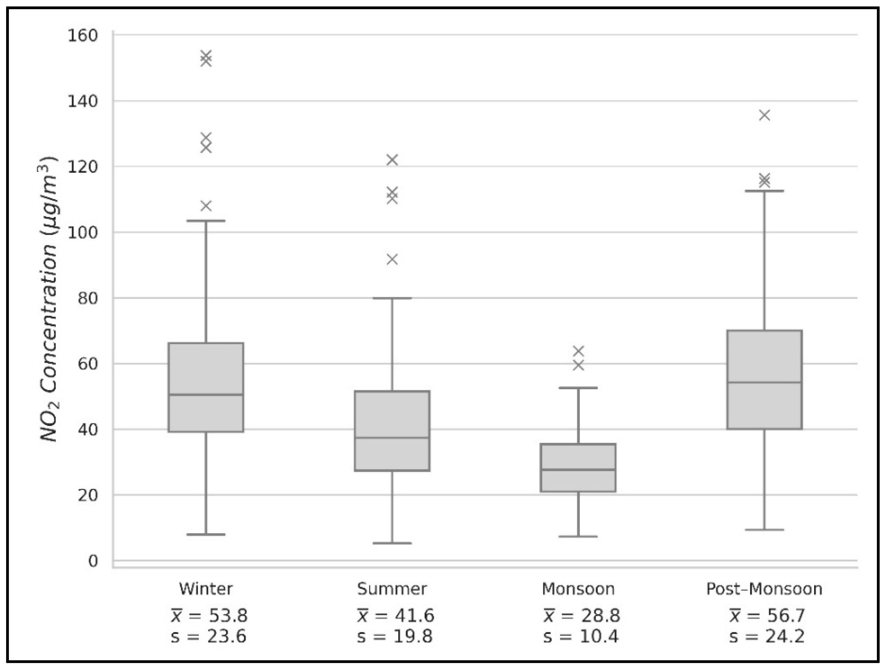
3.1.1. Maps Developed for Estimating Seasonal Air Quality Conditions

Air quality in Delhi varies dramatically with seasons [40], which Figure 2 shows in terms of PM2.5 and NO2 levels in 2021. Monitoring data indicate that concentrations of both pollutants were highest in the post-monsoon and winter seasons and lowest during the monsoon season (Figure 3 and Figure 4). Maximum means across monitoring stations of PM2.5 occurred in the winter (178 ± 35.7 μg/m3; ± precedes the standard deviation), and for NO2 in the post-monsoon (51.9 ± 26.1 μg/m3), whereas minimum levels occurred in the monsoon (41.2 ± 8.08 μg/m3 and 25.9 ± 12.2 μg/m3, respectively). Differences between PM2.5 means between the winter and post-monsoon seasons are trends only, but differences between all other season pairs are statistically significant (ANOVA test, p < 0.05).
Delhi has a massive footprint, and factors that influence local air quality are diverse, impacting different parts of the city differently. For example, during the monsoon season, regional rainfall tends to homogenize air quality across the city. However, in other seasons, local drivers of air quality are more apparent. For example, the rice harvest occurs during the post-monsoon season, primarily in rural areas northwest of Delhi. Because of the short period between rice harvesting and wheat sowing in the same fields, rice straw and other residuals are burned at large scale to accelerate the crop transition process [41], producing major air pollution, particularly particulate releases.
For NO2, differences also were trends only between the post-monsoon and winter and winter versus summer (ANOVA test, p < 0.05), but all other season pairs were significantly different. PM2.5 and NO2 concentrations varied spatially in all years between 2018 and 2021—summer (Figure 5) and post-monsoon (see Figure S2) are examples. Overall, the figures show how PM2.5 and NO2 levels vary spatially, which has implications to estimating conditions where limited monitoring data exist.
Diwali also occurs in the post-monsoon season with the city-scale use of lanterns and fireworks, impacting air conditions with high levels of fine particle releases. The influence on seasonal air quality of rice straw burning and Diwali is made worse by colder air temperatures in the winter, which increases fossil fuel burning for heating [42]. Finally, the impact of these factors is amplified because of intense winter inversions in Delhi, with reduced wind speeds from the West and shallower mixing layers that cap air pollutants, typically resulting in 40 to 80% higher fine particulate levels in winter months [42,43].

3.1.2. Using the Maps to Estimate Air Quality in the Settlements

The main goal here was to estimate air quality at specific settlements where limited monitoring data exist. Such information is key for characterizing possible exposure risks, which may be profound among the vulnerable poor who reside in temporary dwellings in settlements. Geospatial maps were used to estimate PM2.5 and NO2 levels for each of the five settlements, averaged across 2018–2021 (Table 1). Overall, our predictions, both for PM2.5 and NO2, show the mean air quality is poor at all the settlements, with seasonal averages exceeding WHO limits. Mapping suggests air quality is slightly better at Jawahar Camp (located in Kirti Nagar), which is a JJC in the West Delhi district. Conversely, air quality is worst at SG, especially for PM2.5, which is a Resettlement colony in the North West Delhi district (see Table S2).
SG is in a suburban, agricultural area over 10 km from the closest CPCB station. It exemplifies why our model is useful. The model suggests SG has poor air quality across the seasons (see Table 1), being immediately downwind of Haryana and Punjab, where seasonal crop burning occurs [44]—a clear source of soot and particles due to incomplete combustion. However, other factors explain the poor air quality near this settlement. SG also is near National Highway 9, which contributes to locally elevated PM2.5 and NO2 levels, resulting from combustion engines, brake and tire wear, and resuspended dust from moving traffic. Overall, air quality predictions for SG exemplify the usefulness of our model because modeled trends are not immediately obvious based on CPCB point data alone.
Conversely, South West Delhi has the lowest levels of NO2 concentrations across all seasons (Table S3). This area is less built up and has lower traffic activity compared to other areas [45,46]. Gilbert et al. [47] found concentrations of NO2 decreased significantly with logarithmic distance from a highway, while Zhou and Levy [48] found distance–decay gradients range from 200 to 500 m. Because NO2 is a gaseous pollutant, it tends to be greater downwind of major roads, with lower concentrations upwind [47]. This trend is consistent with greater NO2 “hotspots” to the east and southeast of the city center, which aligns with winds primarily coming from the northwest. It also explains estimated higher-than-average NO2 levels at Savda Ghevra (Table S3), which is downwind of National Highway 9.
ANOVA tests (p < 0.05) were performed on extracted data for the settlements for 2018–2021. Estimated PM2.5 and NO2 concentrations across the settlements were statistically similar (p = 0.874 and p = 0.492, respectively), although conditions differ between settlements. All settlements had poor mean air quality over the period 2018–2021. However, Jawahar Camp (KN) consistently had the lowest air pollutant means for 2018–2021, whereas Savda Ghevra had the highest levels (Table 1). Estimated PM2.5 levels at Jawahar Camp were 102 ± 52.8 μg/m3, lower than 119 ± 62.9 μg/m3 to 122 ± 61.3 μg/m3 for the other settlements, and NO2 levels were 40.0 ± 12.43 μg/m3 compared to 41.8 ± 14.4 μg/m3 to 48.5 ± 14.1 μg/m3.
Overall, if one considers PM2.5 levels at the five Delhi settlements, “typical” settlement air quality conditions are worse than Indian averages. The mean 2018–2021 PM2.5 level across the settlements was 117.0 ± 53.5 μg/m3, whereas the Indian average was only 59.5 μg/m3 in 2020. Fine particle exposures are at least double at the informal settlements in Delhi compared with elsewhere in India, implying the risk of respiratory disease and air pollution-related death in the settlements is greater than Indian averages [10].

3.1.3. Implications of Measured Air Quality Data from 2023 on Model Reliability

Thus far, all comparisons between air quality among settlements have been based on mapped approximations using CPCB data, i.e., mean estimates that do not consider local scale differences in air quality within each settlement. Such micro-scale assessments were made in 2023 at a semi-quantitative level. However, before such comparisons can be made, it was necessary to verify that the model’s mean estimates were a reasonable approximation of actual air quality conditions on the ground.
It was impossible to make this comparison during the modeled period because of pandemic restrictions; however, mean and relative differences between measured field data at the settlements and the nearest CPCB station were compared and found to correlate significantly (p < 0.01). The mean PM2.5 level at settlements was 53.6 ± 4.78 μg/m3, whereas the nearest CPCB stations were 41.8 ± 13.1 μg/m3. Bootstrapping analysis showed the shapes of the data series were not significantly different, suggesting that relative changes in data between the settlements and stations are mutually consistent, even if their means are not identical. The same was found for NO2 between the settlements and stations (17.2 ± 9.00 μg/m3 vs. 25.2 ± 11.8 μg/m3, respectively).
These comparisons suggest that model predictions for the settlements using station data provide a reasonable estimate of mean air quality conditions. However, “walkabout” data from 2023 indicate large variations in actual air quality exist as one moves around a settlement or near a local CPCB station. This variance suggests large differences in air quality on local scales, which is exemplified in Figure 6, and suggests that modeled means may not reflect the extremes of pollutant exposures to settlement dwellers. In this walkabout, the mean PM2.5 level was 53.8 ± 10.0 μg/m3, but levels were persistently 70 to 75 μg/m3 near the commercial sites.
Informal settlements are dynamic and bustling places, but activity is not tightly regulated. Therefore, air quality can especially vary on very local scales, both within the settlements and near the CPCB sampling stations that are often found in busy locations (e.g., bus stations, major intersections, etc.). As such, the 2023 field sampling shows that the IDW model provides a reasonable estimate of mean air quality conditions at a location, but it does not capture local factors that pose consequentially greater air pollution exposure risk within a settlement not detected by the citywide model.

3.1.4. Impact of COVID-19 Lockdown on Air Quality

The original purpose of this work was to estimate environmental quality (air and groundwater) conditions in places where no monitoring data exist. However, the study overlapped the COVID-19 lockdown in Delhi in the Summer of 2020. Therefore, the assessment here captured the impact of reduced human activity during the lockdown.
Data and mapping showed the lockdown significantly improved air quality. Mean PM2.5 and NO2 pollutant levels were 42% and 37% lower in summer 2020, respectively, compared to summer 2019 (Figure 5). These data align well with Pandey et al. [49], who found particulate matter (including PM2.5) dropped by 30% in Delhi pre- and post-lockdown, and gaseous pollutants (including NO2) dropped by up to 50% compared to 2019. The findings here also align with national trends during the lockdown period. Verma and Kamyotra [50] found that across India, national average concentrations of PM2.5 were reduced by 45% and NO2 by 54%. Although a significant decrease in pollutants was seen across Delhi, reductions were lower than national averages, possibly because some industrial activity continued, although this is uncertain.

4. Conclusions

A need exists for approaches to extend environmental point data to places lacking monitoring data, particularly for local exposure and health risk assessments, because of the substantial effects of local sources of air pollution across Indian cities and the associated increased risk in disability-adjusted life years and mortality [10]. This need has been emphasized in recent United Nations guidance on increased environmental surveillance for health protection [51] and aligns with Sustainable Development Goals 3, 7, 11 and 17 [32].
In this study, publicly available data were used to create mean air quality maps for Delhi to estimate exposure risks to air pollutants at five informal settlements across the city. The IDW maps reveal that air quality conditions regularly exceed safe levels recommended by the WHO for PM2.5 and NO2. However, the analysis here indicates that some settlements, primarily because of their location, experience relatively poorer air quality than others. Moreover, data suggest that air quality within each settlement can vary widely because of very local factors. Therefore, while the maps are valuable for strategic assessments of air quality, they may not account for critical factors that may significantly impact health exposure risks in informal settlements that often have unregulated burning and micro-industrial activity. It is worth noting that air quality at all settlements improved during the 2020 lockdown, suggesting improved air quality is achievable.
In summary, an easy-to-apply approach is provided here for generating air quality exposure risk maps that can be used for similar locations where public monitoring data are available. It is noteworthy that this work was largely conducted during the COVID-19 pandemic when fieldwork was not possible. Therefore, the work also shows that creativity and innovation can overcome physical limitations, leading to alternate methods for estimating air quality conditions for risk assessments. This is among the work’s novelties. It extends regional monitoring data to predicting air quality at key unmonitored locations, such as vulnerable informal communities, which are often ignored because of a lack of data.

Supplementary Materials

The following supporting information can be downloaded at https://www.mdpi.com/article/10.3390/atmos15091072/s1: Table S1. Average and maximum differences between predicted and known values from seasonal PM2.5 data in 2021 for the IDW and kriging interpolation methods; Table S2. PM2.5 concentrations (μg/m3) extracted from GIS maps for the study settlements; Ajit Vihar (AV), Bhalswa Colony (B), Jawahar Camp in Kirti Nagar (KN), Sanjay Colony Okhla (SC), Savda Ghevra (SG), and the Delhi average of all stations. Values were extracted from 2018 to 2021 according to the following seasons: winter (W); summer (S); monsoon (M); post-monsoon (PM); Table S3. NO2 concentrations (μg/m3) extracted from GIS maps for the study settlements; Ajit Vihar (AV), Bhalswa Colony (B), Jawahar Camp in Kirti Nagar (KN), Sanjay Colony Okhla (SC), Savda Ghevra (SG), and the Delhi average of all stations. Values were extracted from 2018 to 2021 according to the following seasons: winter (W); summer (S); monsoon (M); post-monsoon (PM); Figure S1. Maps of PM2.5 and NO2 concentration for Post–monsoon 2018 to 2021 produced using IDW from samples at the Continuous Ambient Air Quality Monitoring Stations (CAAQMS), across the National Capital Territory (NCT) of Delhi. Figure S2. Examples of air pollution sources and conditions in selected informal settlements examined in this study. Photos taken in June 2023.

Author Contributions

Conceptualization, D.W.G., R.W.H. and M.J.G.; Methodology, R.W.H., D.W.G., M.J.G., M.-V.P. and K.J.; Validation, R.W.H., D.W.G., K.J., M.-V.P. and A.N.; Formal Analysis, R.W.H. and D.W.G.; Investigation, R.W.H. and D.J.; Data Curation, R.W.H. and M.-V.P.; Writing—Original Draft Preparation, R.W.H., D.W.G. and M.J.G.; Writing—Review and Editing, R.W.H., D.W.G., M.J.G., M.-V.P., K.J., D.J., A.N. and S.Z.A.; Visualization, R.W.H. and M.-V.P.; Supervision, D.W.G. and M.J.G.; Project Administration, D.W.G.; Funding Acquisition, D.W.G. All authors have read and agreed to the published version of the manuscript.

Funding

This research was funded by the GCRF Water Security and Sustainable Development Hub (grant number: ES:/8008179/1) and the Rising Tide Foundation (grant number: RTF-19-110).

Institutional Review Board Statement

This is not applicable because the study did not involve human or animal subjects.

Informed Consent Statement

Not applicable.

Data Availability Statement

Analysis data are available in the Newcastle University library archives. Public data can be found at https://airquality.cpcb.gov.in/ccr/#/caaqm-dashboard-all/caaqm-landing (accessed 4 September 2024).

Acknowledgments

We would like to acknowledge the contribution of the following agencies in generating the CAAQMS and groundwater data: Central Pollution Control Board (CPCB); Delhi Pollution Control Committee (DPCC); and India Meteorological Department (IMD).

Conflicts of Interest

The authors declare no conflicts of interest.

References

  1. Bardhan, R.; Pan, J. The Why? How? What? and What-ifs of Mass Slum Rehabilitation Housing in India. In Informal Settlements of the Global South, 1st ed.; Karunaratne, G., Ed.; Routledge: London, UK, 2023. [Google Scholar]
  2. Kundu, D.; Pandey, A.K. World Urbanisation: Trends and Patterns. In Developing National Urban Policies; Kundu, D., Sietchiping, R., Kinyanjui, M., Eds.; Springer: Singapore, 2020. [Google Scholar] [CrossRef]
  3. World Bank. World Development Indicators. Urban Development. Available online: https://www.worldbank.org/en/topic/urbandevelopment/overview#1 (accessed on 13 May 2022).
  4. O’Neill, A. Urbanization in India 2021. Statista. Available online: https://www.statista.com/statistics/271312/urbanization-in-india/#statisticContainer (accessed on 1 August 2023).
  5. Ward, J. Will Future Megacities Be a Marvel or a Mess? Look at New Delhi. The Economic Times, 2018. Available online: https://economictimes.indiatimes.com/news/politics-and-nation/will-future-megacities-be-a-marvel-or-a-mess-look-at-new-delhi/articleshow/66486600.cms?from=mdr (accessed on 2 September 2024).
  6. Pedro, A.A.; Queiroz, A.P. Slum: Comparing municipal and census basemaps. Habitat Int. 2019, 83, 30–40. [Google Scholar] [CrossRef]
  7. Ezeh, A.; Oyebode, O.; Satterthwaite, D.; Chen, Y.-F.; Ndugwa, R.; Sartori, J.; Mberu, B.; Melendez-Torres, G.J.; Haregu, T.; Watson, S.I.; et al. The history, geography, and sociology of slums and the health problems of people who live in slums. Lancet 2017, 389, 547–558. [Google Scholar] [CrossRef] [PubMed]
  8. World Health Organization. Diarrhoeal Disease: Key Facts. Available online: https://www.who.int/news-room/fact-sheets/detail/diarrhoeal-disease#:~:text=Diarrhoea%20is%20usually%20a%20symptom,a%20result%20of%20poor%20hygiene (accessed on 10 May 2022).
  9. Brook, R.D.; Rajagopalan, S.; Pope, C.A., III; Brook, J.R.; Bhatnagar, A.; Diez-Roux, A.V.; Kaufman, J.D. Particulate Matter Air Pollution and Cardiovascular Disease: An Update to the Scientific Statement from the American Heart Association. Circulation 2010, 121, 2331–2378. [Google Scholar] [CrossRef] [PubMed]
  10. De Bont, J.; Krishna, B.; Stafoggia, M.; Banerjee, T.; Dholakia, H.; Garg, A.; Ingole, V.; Jaganathan, S.; Kloog, I.; Lane, K.; et al. Ambient air pollution and daily mortality in ten cities of India: A causal modelling study. Lancet Planet. Health 2024, 8, e433–e440. [Google Scholar] [CrossRef]
  11. Amoah, I.D.; Pillay, L.; Deepnarian, N.; Awolusi, O.; Pillay, K.; Ramlal, P.; Bux, F. Detection of SARS-CoV-2 RNA on contact surfaces within shared sanitation facilities. Int. J. Hyg. Environ. Health 2021, 236, 113807. [Google Scholar] [CrossRef]
  12. Sahoo, K.C.; Dubey, S.; Dash, G.C.; Sahoo, R.K.; Sahay, M.R.; Negi, S.; Mahapatra, P.; Bhattacharya, D.; Sahoo, B.; Pani, S.P.; et al. A Systematic Review of Water, Sanitation, and Hygiene for Urban Poor in Low- and Middle-Income Countries during the COVID-19 Pandemic through a Gendered Lens. Int. J. Environ. Res. Public Health 2022, 19, 11845. [Google Scholar] [CrossRef]
  13. Al-Bahrani, H.S.; Al-Rammahi, A.H.; Al-Mamoori, S.K.; Al-Maliki, L.A.; Nadhir, A.A. Groundwater detection and classification using remote sensing and GIS in Najaf, Iraq. Groundw. Sustain. Dev. 2022, 19, 100838. [Google Scholar] [CrossRef]
  14. Patra, S.; Sahoo, S.; Mishra, P.; Mahapatra, S.C. Impacts of urbanization on land use /cover changes and its probable implications on local climate and groundwater level. J. Urban Manag. 2018, 7, 70–84. [Google Scholar] [CrossRef]
  15. Lin, Y.C.; Shih, H.S.; Lai, C.Y.; Tai, J.K. Investigating a Potential Map of PM2.5 Air Pollution and Risk for Tourist Attractions in Hsinchu County, Taiwan. Int. J. Environ. Res. Public Health 2020, 17, 8691. [Google Scholar] [CrossRef]
  16. Amann, M.; Purohit, P.; Bhanarkar, A.D.; Bertok, I.; Borken-Kleefeld, J.; Cofala, J.; Vardhan, B.H. Managing future air quality in megacities: A case study for Delhi. Atmos. Environ. 2017, 161, 99–1111. [Google Scholar] [CrossRef]
  17. Nidhi; Jayaraman, G. Air quality and respiratory health in Delhi. Environ. Monit. Assess. 2007, 135, 313–325. [Google Scholar] [CrossRef] [PubMed]
  18. Adhikary, P.P.; Dash, C.J.; Chandrasekharan, H.; Rajput, T.B.S.; Dubey, S.K. Evaluation of groundwater quality for irrigation and drinking using GIS and geostatistics in a peri-urban area of Delhi, India. Arab. J. Geosci. 2012, 5, 1423–1434. [Google Scholar] [CrossRef]
  19. Bidhuri, S.; Khan, M.M.A. Assessment of Groundwater Quality of Central and Southeast Districts of NCT of Delhi. J. Geol. Soc. India 2020, 95, 95–103. [Google Scholar] [CrossRef]
  20. World Health Organization. A Global Overview of National Regulations and Standards for Drinking-Water Quality; World Health Organization: Geneva, Switzerland, 2018.
  21. World Health Organization. Ambient (Outdoor) Air Pollution. Available online: https://www.who.int/news-room/fact-sheets/detail/ambient-(outdoor)-air-quality-and-health (accessed on 23 April 2022).
  22. Government of India. Census of India 2011, National Population Register & Socio Economic and Caste Census; Office of the Registrar General and Census Commissioner, India (ORGI): New Delhi, India, 2011.
  23. DDA. Master Plan for Delhi—2021; Delhi Development Authority: New Delhi, India, 2020.
  24. Biswas, A.; Gangwar, D. Studying the Water Crisis in Delhi Due to Rapid Urbanization and Land Use Transformation. Int. J. Urban Sustain. Dev. 2021, 13, 199–213. [Google Scholar] [CrossRef]
  25. Maji, K.J.; Namdeo, A.; Bramwell, L. Driving factors behind the continuous increase of long-term PM2.5-attributable health burden in India using the high-resolution global datasets from 2001 to 2020. Sci. Total Environ. 2023, 866, 161435. [Google Scholar] [CrossRef]
  26. Joshi, P.; Chauhan, A.; Dua, P.; Malik, S.; Liou, Y.-A. Physicochemical and biological analysis of river Yamuna at Palla station from 2009 to 2019. Sci. Rep. 2022, 12, 2870. [Google Scholar] [CrossRef]
  27. Cities of Delhi. Categorisation of Settlement in Delhi; Centre for Policy Research: New Delhi, India, 2015. [Google Scholar]
  28. Bag, S.; Seth, S.; Gupta, A. A Comparative Study of Living Conditions in Slums of Three Metro Cities in India; Leeds University Business School Working Paper 2016, (16-07); Centre for Development Economics, Delhi School of Economics: Delhi, India, 2016. [Google Scholar]
  29. CPCB. Central Control Room for Air Quality Management—Delhi NCR. Available online: https://app.cpcbccr.com/ccr/#/login (accessed on 15 March 2022).
  30. US Environmental Protection Agency [US EPA]. Nitrogen Dioxide (NO2) Pollution. Available online: https://www.epa.gov/no2-pollution/basic-information-about-no2. (accessed on 2 August 2022).
  31. US EPA. Health and Environmental Effects of Particulate Matter (PM). Available online: https://www.epa.gov/pm-pollution/health-and-environmental-effects-particulate-matter-pm (accessed on 30 August 2022).
  32. Fuller, R.; Landrigan, P.J.; Balakrishnan, K.; Bathan, G.; Bose-O’Reilly, S.; Brauer, M.; Caravanos, J.; Yan, C. Pollution and health: A progress update. Lancet Planet. Health 2022, 6, E535–E547. [Google Scholar] [CrossRef]
  33. ArcGIS Desktop, Version 10.8.1; ESRI: Redlands, CA, USA, 2020.
  34. Minitab Statistical Software, Version 21; Minitab LLC: State College, PA, USA, 2021.
  35. Krause, E. Dealing with Extreme Values in Kriging. Available online: https://www.esri.com/arcgis-blog/products/arcgis-desktop/analytics/dealing-with-extreme-values-in-kriging/?rmedium=blogs_esri_com&rsource=/esri/arcgis/2012/05/07/dealing-with-extreme-values-in-kriging/ (accessed on 5 June 2022).
  36. ESRI. How Inverse Distance Weighted Interpolation Works. Available online: https://desktop.arcgis.com/en/arcmap/latest/extensions/geostatistical-analyst/how-inverse-distance-weighted-interpolation-works.htm#GUID-CCCB3B04-F8A1-4D90-8D7C-31D5AF079735 (accessed on 11 April 2022).
  37. EPA. Air Monitoring Methods—Criteria Pollutants. Available online: https://www.epa.gov/amtic/air-monitoring-methods-criteria-pollutants (accessed on 1 September 2024).
  38. IQAir. World's Most Polluted Cities (Historical Data 2017–2023). Available online: https://www.iqair.com/gb/world-most-polluted-cities (accessed on 2 September 2024).
  39. Singh, R.; Dewan, A. Air conditioners, airborne infection prevention and air pollution in buildings in New Delhi. Int. J. Tuberc. Lung Dis. 2021, 26, 288–290. [Google Scholar] [CrossRef] [PubMed]
  40. Shankar, S.; Gadi, R. Variation in Air Quality over Delhi Region: A Comparative Study for 2019 and 2020. Aerosol Sci. Eng. 2022, 6, 278–295. [Google Scholar] [CrossRef]
  41. Sembhi, H.; Wooster, M.; Zhang, T.; Sharma, S.; Singh, N.; Agarwal, S.; Boesch, H.; Gupta, S.; Misra, A.; Tripathi, S.N.; et al. Post-monsoon air quality degradation across Northern India: Assessing the impact of policy-related shifts in timing and amount of crop residue burnt. Environ. Res. Lett. 2020, 15, 104067. [Google Scholar] [CrossRef]
  42. Guttikunda, S.K.; Gurjar, B.R. Role of meteorology in seasonality of air pollution in megacity Delhi, India. Environ. Monit. Assess. 2012, 184, 3199–3211. [Google Scholar] [CrossRef]
  43. Shridhar, V.; Khillare, P.S.; Agarwal, T.; Ray, S. Metallic species in ambient particulate matter at rural and urban location of Delhi. J. Hazard. Mater. 2010, 175, 600–607. [Google Scholar] [CrossRef]
  44. Voiland, A.; Dauphin, L. A Shot of Smoke for Delhi. Available online: https://earthobservatory.nasa.gov/images/149086/a-shot-of-smoke-for-delhi (accessed on 14 May 2022).
  45. TomTom. New Delhi Traffic. Available online: https://www.tomtom.com/traffic-index/new-delhi-traffic/ (accessed on 19 October 2022).
  46. Pramanik, S.; Punia, M. Land Use Land Cover Change and Surface Urban Heat Island Intensity: Source—Sink Landscape Based Study in Delhi, India. Environ. Dev. Sustain. 2020, 22, 7331–7356. [Google Scholar] [CrossRef]
  47. Gilbert, N.L.; Woodhouse, S.; Stieb, D.M.; Brook, J.R. Ambient nitrogen dioxide and distance from a major highway. Sci. Total Environ. 2003, 312, 43–46. [Google Scholar] [CrossRef]
  48. Zhou, Y.; Levy, J.I. Factors influencing the spatial extent of mobile source air pollution impacts: A meta-analysis. BMC Public Health 2007, 7, 89. [Google Scholar] [CrossRef]
  49. Pandey, M.; George, M.; Gupta, R.K.; Gusain, D.; Dwivedi, A. Impact of COVID-19 induced lockdown and unlock down phases on the ambient air quality of Delhi, capital city of India. Urban Clim. 2021, 39, 100945. [Google Scholar] [CrossRef]
  50. Verma, R.L.; Kamyotra, J.S. Impacts of COVID-19 on Air Quality in India. Aerosol Air Qual. Res. 2021, 21, 200482. [Google Scholar] [CrossRef]
  51. United Nations Environment Programme. Bracing for Superbugs: Strengthening Environmental Action in the One Health Response to Antimicrobial Resistance. Available online: https://www.unep.org/resources/superbugs/environmental-action (accessed on 21 July 2024).
Figure 1. Map of study settlements and the National Capital Territory (NCT) of Delhi in India. The settlements include Bhalswa Colony (B), Ajit Vihar (AV), Savda Ghevra (SG), Sanjay Colony Okhla (SC), and Kirti Nagar (KN). Also shown are Roadside and Background CAAQMSs. Roadside stations are stations within 25 m of a road. Photos of common conditions in the settlements are provided in Figure S1 (Supplementary Materials, SM).
Atmosphere 15 01072 g001
Figure 2. Seasonal maps of PM2.5 (AD) and NO2 (EH) concentration throughout 2021 produced using IDW from samples at the Continuous Ambient Air Quality Monitoring Stations (CAAQMSz) across the National Capital Territory (NCT) of Delhi.
Atmosphere 15 01072 g002
Figure 3. Boxplots of Continuous Ambient Air Quality Monitoring Station (CAAQMS) values for each season calculated using data from 2018 to 2021 for the pollutant PM2.5 (μg/m3), including mean ( x ¯ ) and standard deviation (s) for each season.
Atmosphere 15 01072 g003
Figure 4. Boxplots of Continuous Ambient Air Quality Monitoring Station (CAAQMS) values for each season calculated using data from 2018 to 2021 for the pollutant NO2 (μg/m3), including mean ( x ¯ ) and standard deviation (s) for each season.
Atmosphere 15 01072 g004
Figure 5. Maps of PM2.5 (AD) and NO2 (EH) concentration for summer 2018 to 2021 produced using IDW from samples at the Continuous Ambient Air Quality Monitoring Stations (CAAQMSs) across the National Capital Territory (NCT) of Delhi.
Atmosphere 15 01072 g005
Figure 6. Variations in PM2.5 concentrations as one walked through Kirti Nagar on the morning of June 19, 2023. PM2.5 concentrations increase and decrease based on shops (e.g., a furniture store), stalls, construction sites, and many other activities that occur in an informal settlement.
Atmosphere 15 01072 g006
Table 1. Extracted and interpolated mean and standard deviation of PM2.5 and NO2 levels (μg/m3) at the five informal settlements according to season (2018–2021).
SettlementPollutantSummerWinterMonsoonPost-Monsoon
Ajit ViharPM2.5164 ± 25.480.0 ± 19.645.5 ± 4.3188 ± 21.7
NO253.6 ± 4.040.0 ± 7.526.9 ± 4.556.2 ± 10.0
Bhalswa ColonyPM2.5168 ± 26.080.9 ± 19.945.6 ± 3.6191 ± 21.5
NO252.6 ± 5.936.8 ± 5.824.3 ± 3.856.7 ± 8.0
Jawahar Camp (Kirti Nagar)PM2.5148 ± 16.169.6 ± 22.138.3 ± 5.1153 ± 7.2
NO247.6 ± 2.537.4 ± 12.825.2 ± 5.349.9 ± 8.0
Sanjay Colony OkhlaPM2.5162 ± 17.085.4 ± 20.845.1 ± 5.0187 ± 15.5
NO243.5 ± 10.441.9 ± 17.127.8 ± 1.453.9 ± 13.4
Savda GhevraPM2.5175 ± 10.283.7 ± 19.047.2 ± 8.8182 ± 15.0
NO259.6 ± 3.844.4 ± 11.030.3 ± 6.159.5 ± 6.0
Disclaimer/Publisher’s Note: The statements, opinions and data contained in all publications are solely those of the individual author(s) and contributor(s) and not of MDPI and/or the editor(s). MDPI and/or the editor(s) disclaim responsibility for any injury to people or property resulting from any ideas, methods, instructions or products referred to in the content.

