1. Introduction
Groundwater recharge is a basic component of the groundwater system [
1]. The groundwater system of the irrigated district belongs to the half-natural system, as well as the water cycle, which is more complex due to the influence of human activities [
2,
3]. With the rapid development of industry and agriculture, the contradiction between the supply and demand of water is prominent in the day to day; however, less attention is devoted to recognizing the characteristics of groundwater supply, runoff, and drainage, which results in the phenomena of ground subsidence, brackish water, and saltwater intrusion [
4,
5]. The objective of this research is to find out the characteristics of groundwater recharge in the irrigation area, providing a theoretical basis for the scientific, rational utilization, and deployment of groundwater resources that can manage the stable and healthy development of irrigation areas.
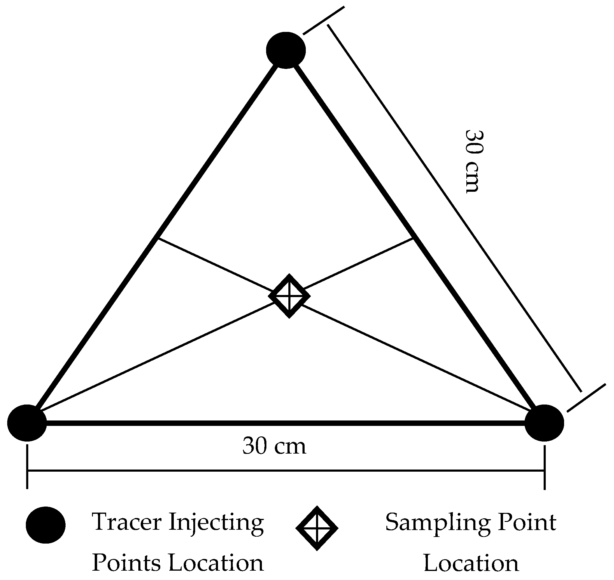
The hydrogeological parameters are an indispensable data source for solving hydrogeological calculations. One of the most important parameters is the recharge rate, which is often difficult to determine by conventional methods. Since the mid-80s of the last century, researchers have been using different methods to study groundwater recharge mechanisms [
6,
7]. There are four methods that are most influential and representative [
8,
9,
10]: Physical Method (the water-balance, water table fluctuation), Chemical Tracer Method, Lysimeter, and Numerical Simulation Methods. The spatial-temporal variations of groundwater are complicated, which make methods such as the Lysimeter and Physical Method less efficient in discovering the evolutionary characteristics of groundwater recharge in a study area [
11,
12]. In comparison to these methods, the Artificial Tracer method has the advantage of not requiring a large volume of hydrological data and it obtains data more easily. Thus, it is usually chosen to estimate groundwater recharge and simultaneously determine the recharge sources, the flow speed, migration time, and to identify the preferred flow paths [
13,
14,
15]. In addition, the artificial tracer has the characteristic of wide selectivity; any material with properties of high water solubility, chemical stability, low environmental pollution, simple measurement, high precision, low testing expense, etc., can be used as a tracer.
The Artificial Tracer method is consistently used in various types of hydrological and hydrogeological environments to attain information about water movement and contaminant transport. Dravis et al. [
16] found the source of pollutants in the water of the study area by using sulfur hexafluoride as a tracer in a large-scale test over the study area. Hulla et al. [
17] used tracer methods in Slovakia to check deep excavation sealing element efficiency, which was significant for protecting water resources from radioactive contamination. While estimating the recharge rate and discharge rate have relied to a large extent on tracer (neon, bromide, chloride, and tritium) profiles, many radioisotopes were used to estimate the flow rates [
18]. Sukhija et al. [
19] used an artificial and geochemical tracer to estimate the intake area of a confined aquifer and the recharge rates of the intake area, thus calculating the amount of recharge by direct precipitation to the confined aquifer. Therefore, researchers have adopted an artificial tracer method to study the correlation characteristics of groundwater recharge for a long time. Zimmermann et al. [
20] pioneered the use of neon as a tracer to study soil water transport. Neon was widely used as an applied tracer [
21,
22,
23]. Afterwards, many researchers used bromide as a tracer to study soil solute transport [
24,
25,
26]. Flint et al. [
27] used bromide to procure a better understanding of the movement and transport of water through the soil profile. However, it was rare to use a bromine tracer to study groundwater recharge. Rice et al. [
28] used a bromine tracer technique to evaluate the recharge rate of bare land under rainfall and irrigation conditions (45 cm). These studies usually put tracers on the surface, which reduces the reliability of the evaluation results. Subsequently, artificial tracers were put to the surface or underground at a certain depth, which could overcome the effects of the soil roots and large voids. Rangarajan et al. [
29] analyzed the recharge rate of several basins and watersheds in India by the tritium injection method, which showed the recharge rate ranged from 24 to 198 mm year
−1 or 4.1 to 19.7% of the local average seasonal rainfall. Multiple age tracers were measured to estimate groundwater residence times in the regional aquifer system underlying southwestern Oman, which proved that the age of the confined groundwater was longer in the Dhofar Mountains [
30]. WU et al. [
31] and Tan et al. [
32] took the North China Plain and the Central Plain as an example, using the tracer method to study the groundwater recharge under the conditions of irrigation and non-irrigation.
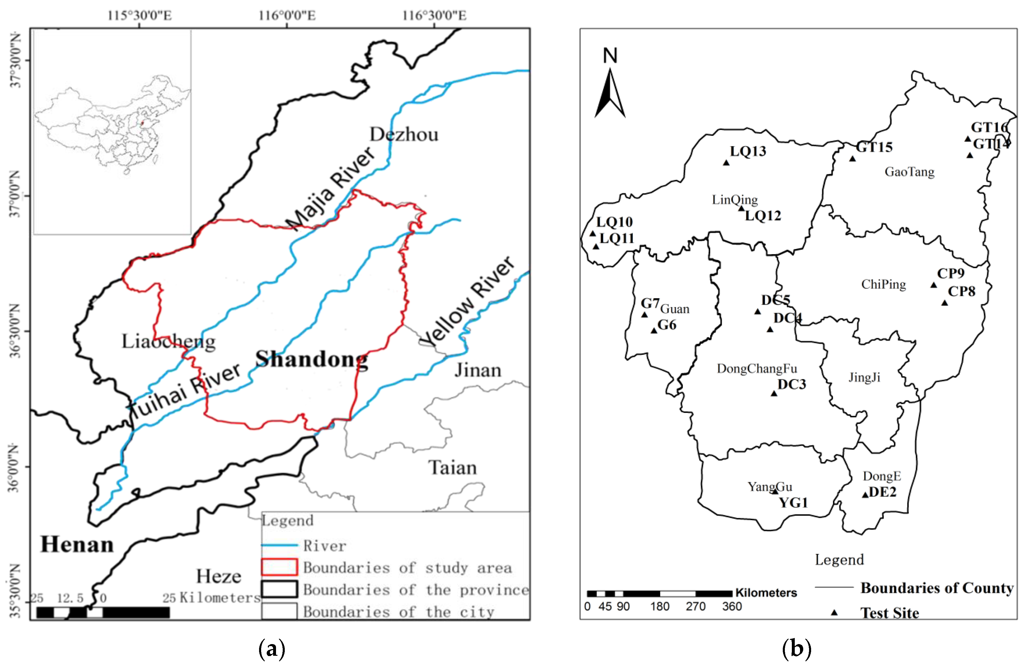
The main objectives of this study are to (1) evaluate the influence of different irrigation district locations, irrigation regimes, and crop types on the groundwater recharge in the Weishan Irrigated District; (2) establish the relationship between the groundwater recharge and the irrigation and rainfall; and (3) develop the relationship between the groundwater level and the comprehensive recharge coefficient.
4. Conclusions
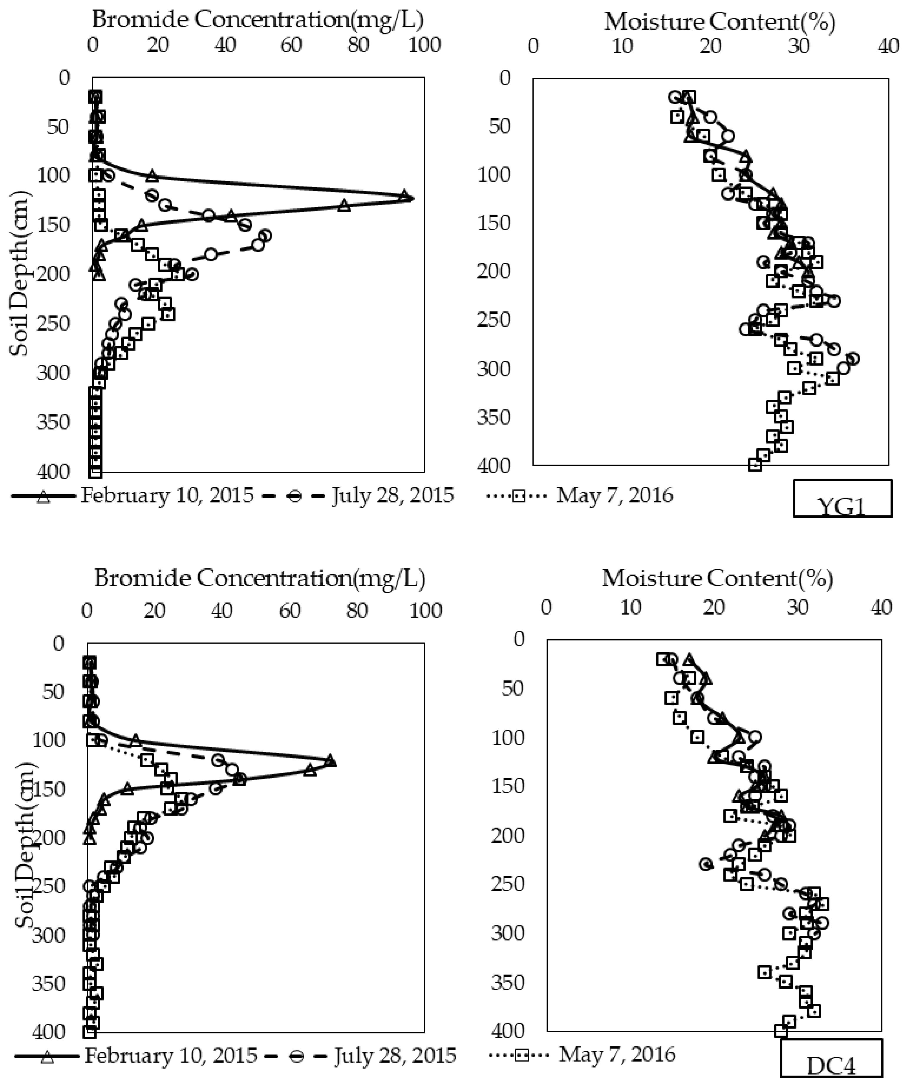
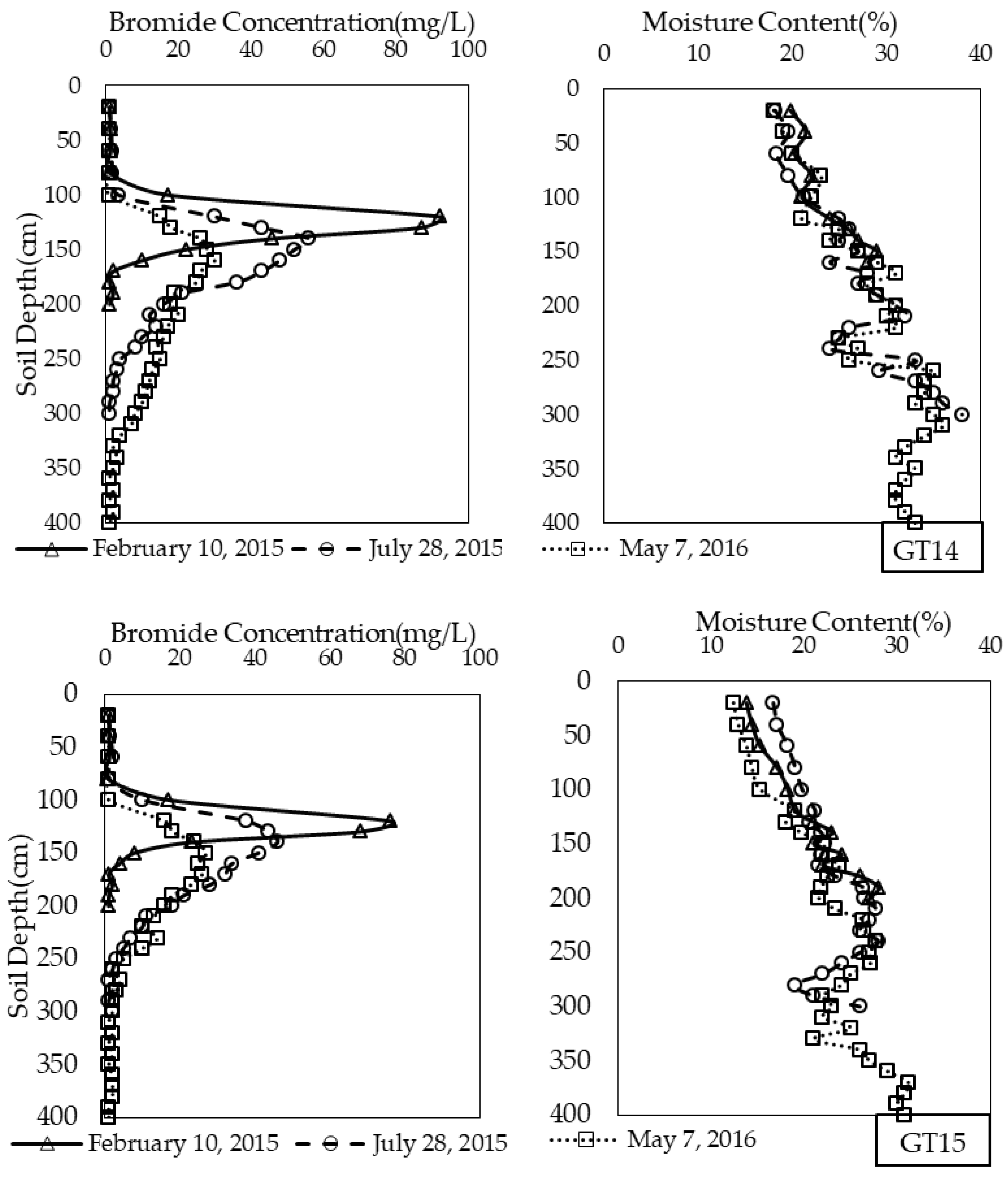
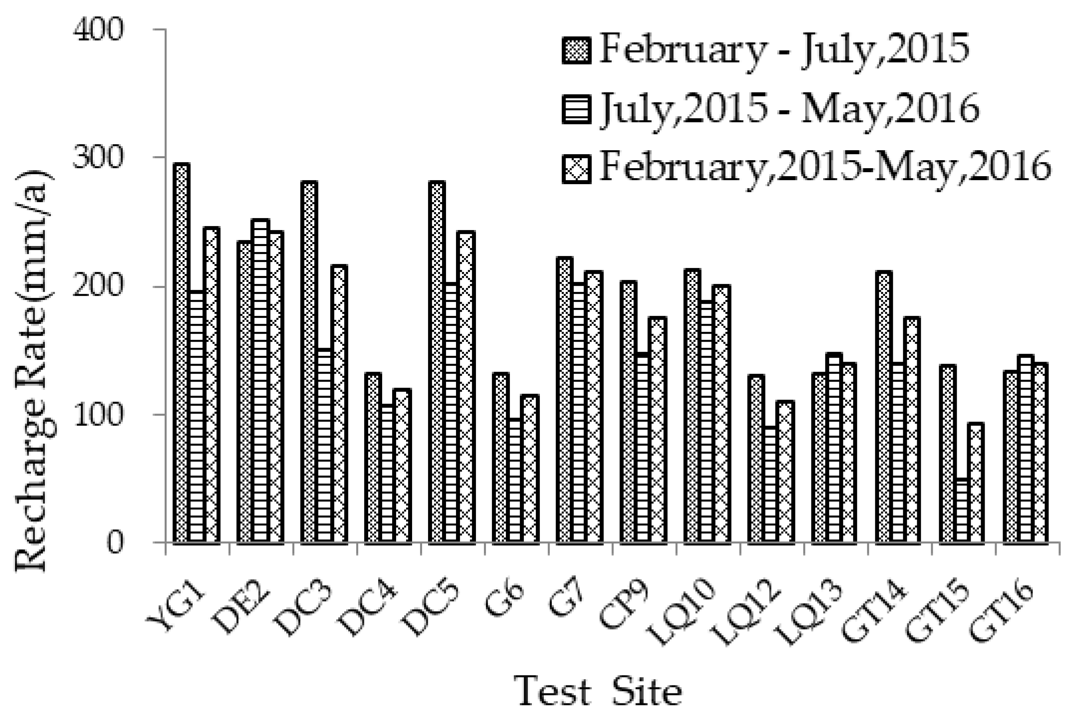
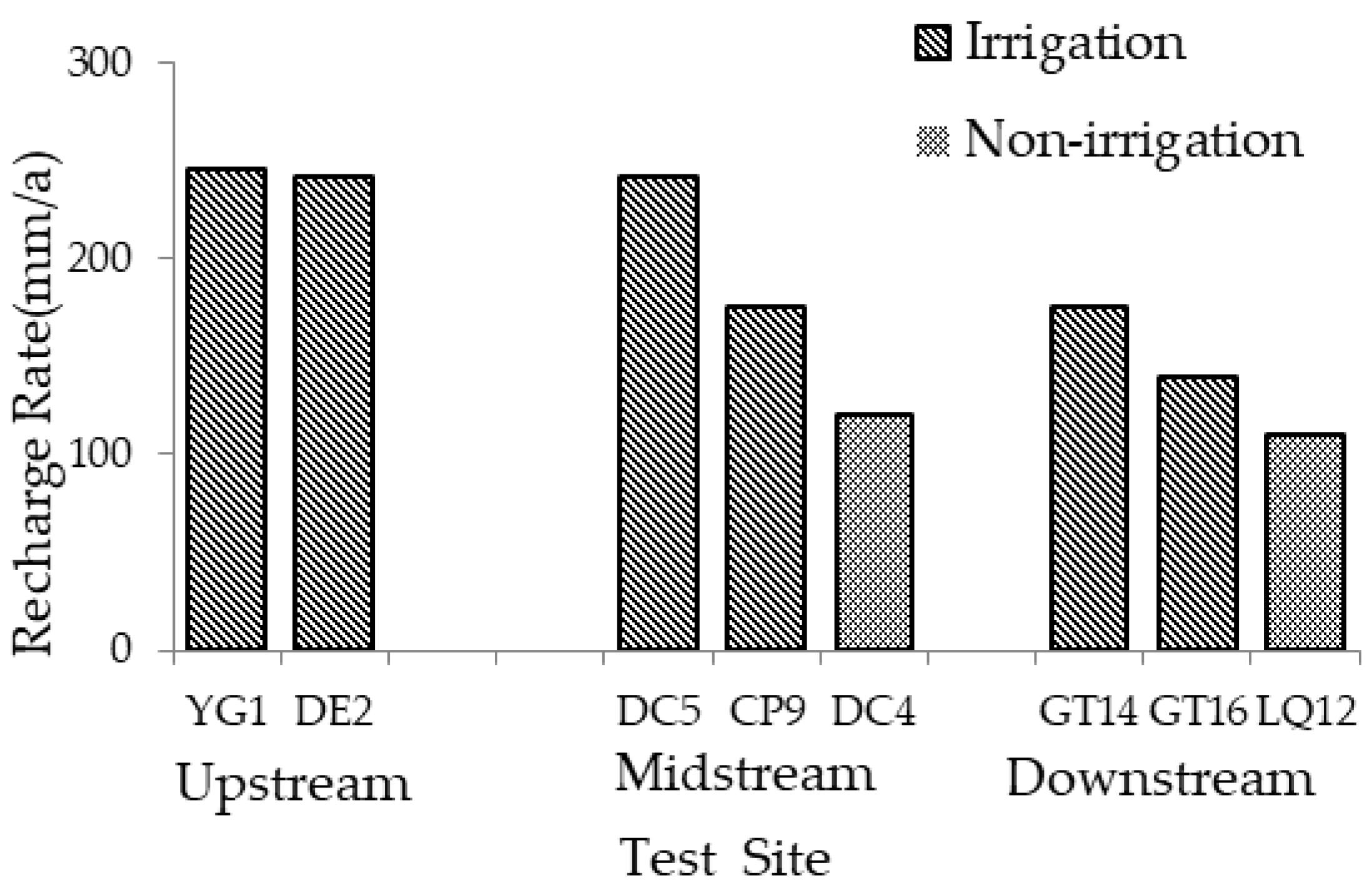
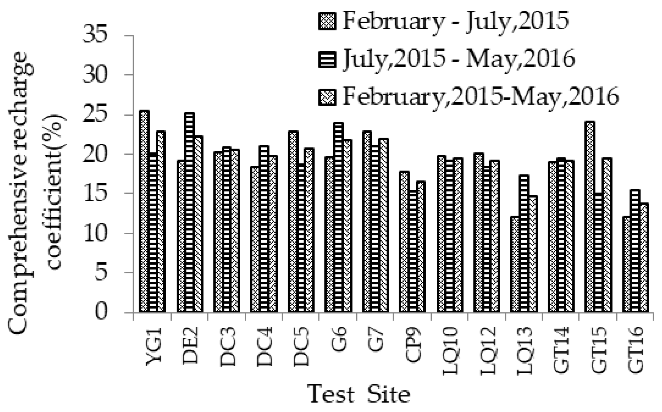
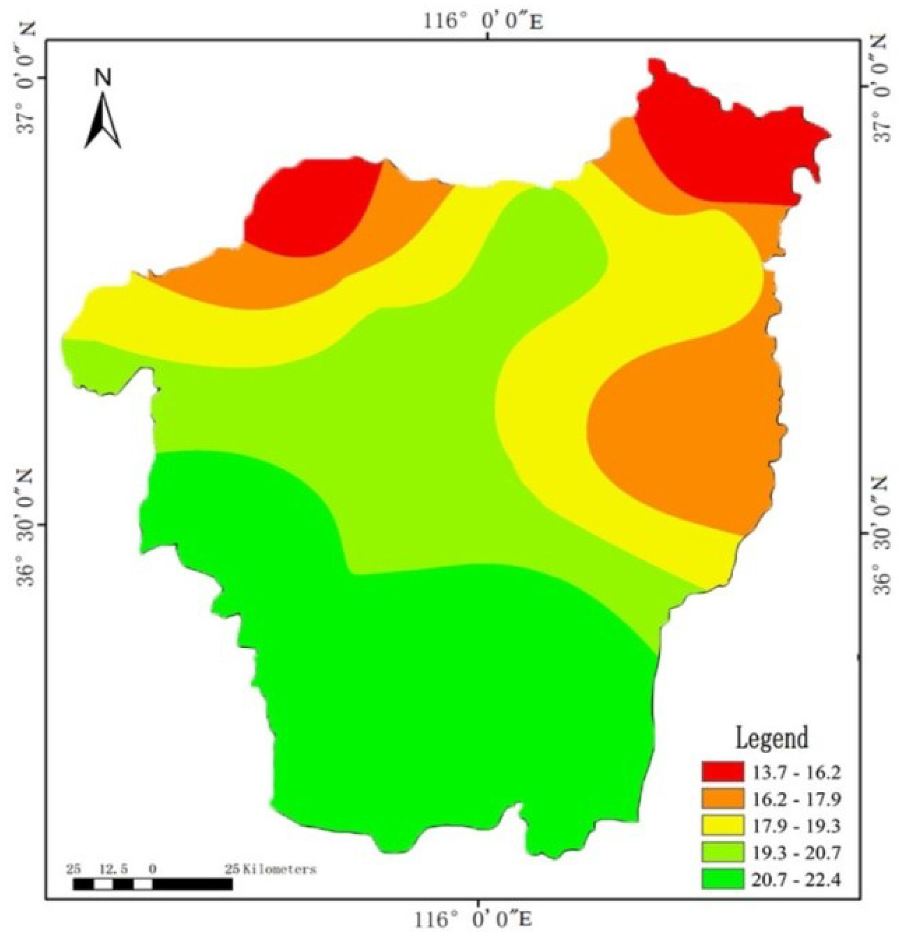
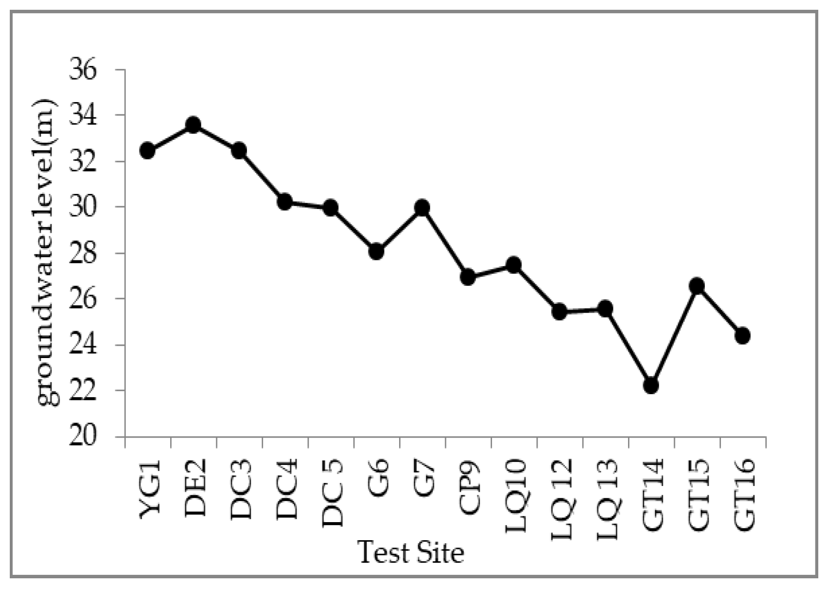
By comparing the obtained data of other researchers near the research area (North China Plain), this study indicates that the tracer test results can be used for the preliminary study of groundwater recharge characteristics in the Weishan Irrigated District. Average recharge rates and recharge coefficients determined by bromide tracing for different sites in the Weishan Irrigated District from 2015 to 2016 were 85.5–243 mm/a and 13.7–22.4%, respectively. By measuring bromine concentration at different sampling locations, we can conclude that the variation in the recharge rates and recharge coefficient reflects the irrigation district locations, different crops, and irrigation regimes. (1) The recharge rate of the upstream district was greater than the downstream district, which is mainly due to the difference in soil texture. The coarser the soil texture is, the greater the recharge of precipitation and irrigation water to the ground; (2) Irrigation resulted in more recharge compared to non-irrigation, which is mainly because the utilization rate of irrigation water in irrigated cropland is low; (3) Different crop types resulted in different recharge rates. Under certain conditions, the recharge rate for winter wheat-summer maize was greater than that for cotton, mainly due to the vastly different water use coefficient of these crops.
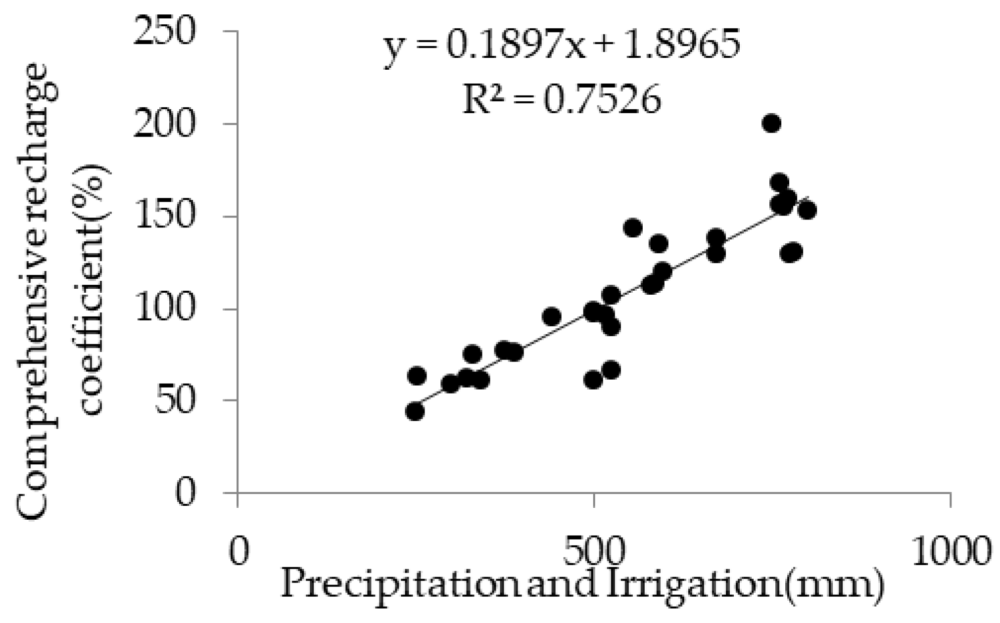
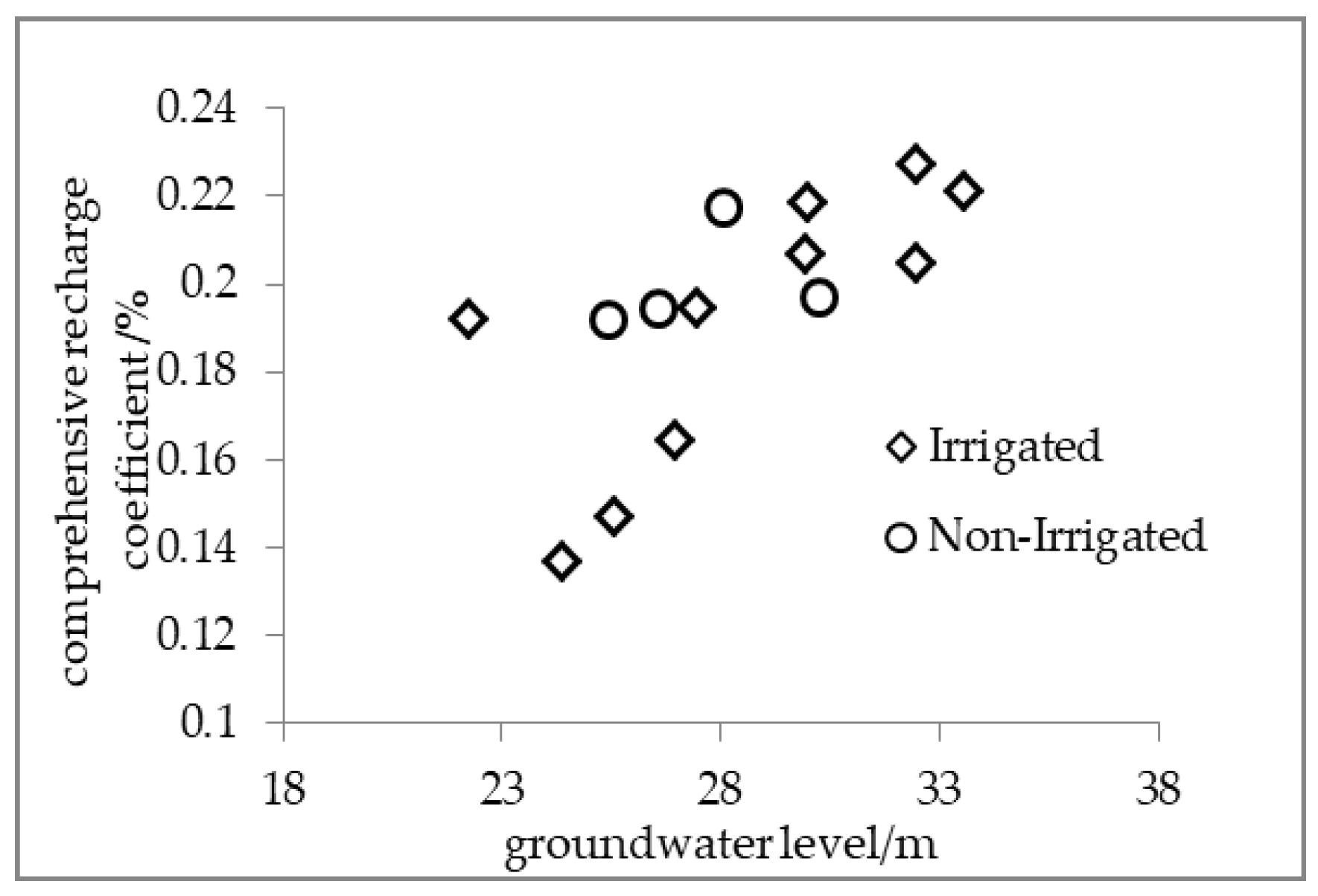
A certain positive correlation was found between the groundwater level and comprehensive recharge coefficient at the higher groundwater level. But rainfall and irrigation water are mainly used for evaporation rather than for groundwater recharge at the higher groundwater level. At the time, the correlation between them is also affected. Recharge rates estimated from the first year of tracer travel were greater than those from the second year. This difference results in part from the periodicity of total precipitation and irrigation.
Based on the above, we recommend that the irrigation area allocate and use water resources according to the irrigation time, the actual precipitation, and the groundwater level. Water resources of the Yellow River are heavily utilized during the irrigation period, thereby we can reduce the surface water resources and make rational use of the groundwater resources in the upstream and middle reaches with relatively high groundwater level. In particular, it must be noted that we should intensify the management of groundwater resources to avoid secondary salinization in some areas of the YG that might be caused by the high groundwater level. In the lower reaches of the Weishan Irrigated District with shallow groundwater, the utilization of surface water can be appropriately increased for agricultural irrigation and social production to reduce groundwater exploitation. In the flood season, the supply of groundwater increased with the increase of precipitation. At this time, the groundwater can be properly exploited to meet the needs of agriculture and social development. In other months, the utilization volume of the groundwater can be reduced. We suggest that more surface water resources, such as river water and reclaimed water, become the main water supply source in order to restore the underground water and alleviate the secondary disasters caused by the overexploitation of groundwater. It must be noted that applications of the sprinkler irrigation technique to local conditions can play an important role in providing higher water efficiency.
Further study needs to determine the recharge rates for more sites and over a longer period of time, strengthening the monitoring of variables in the potential season. Moreover, improving the testing precision of bromine can effectively improve the evaluation accuracy.


