Two Dimensional Model for Backwater Geomorphology: Darby Creek, PA


Abstract
:1. Introduction
2. Materials and Methods
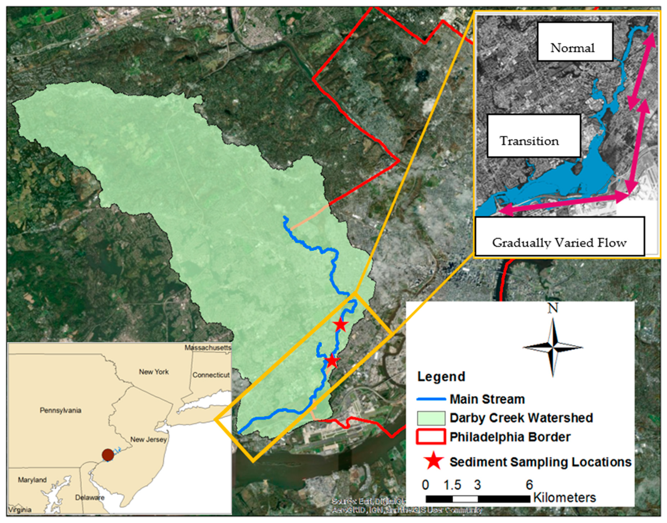
2.1. Study Area
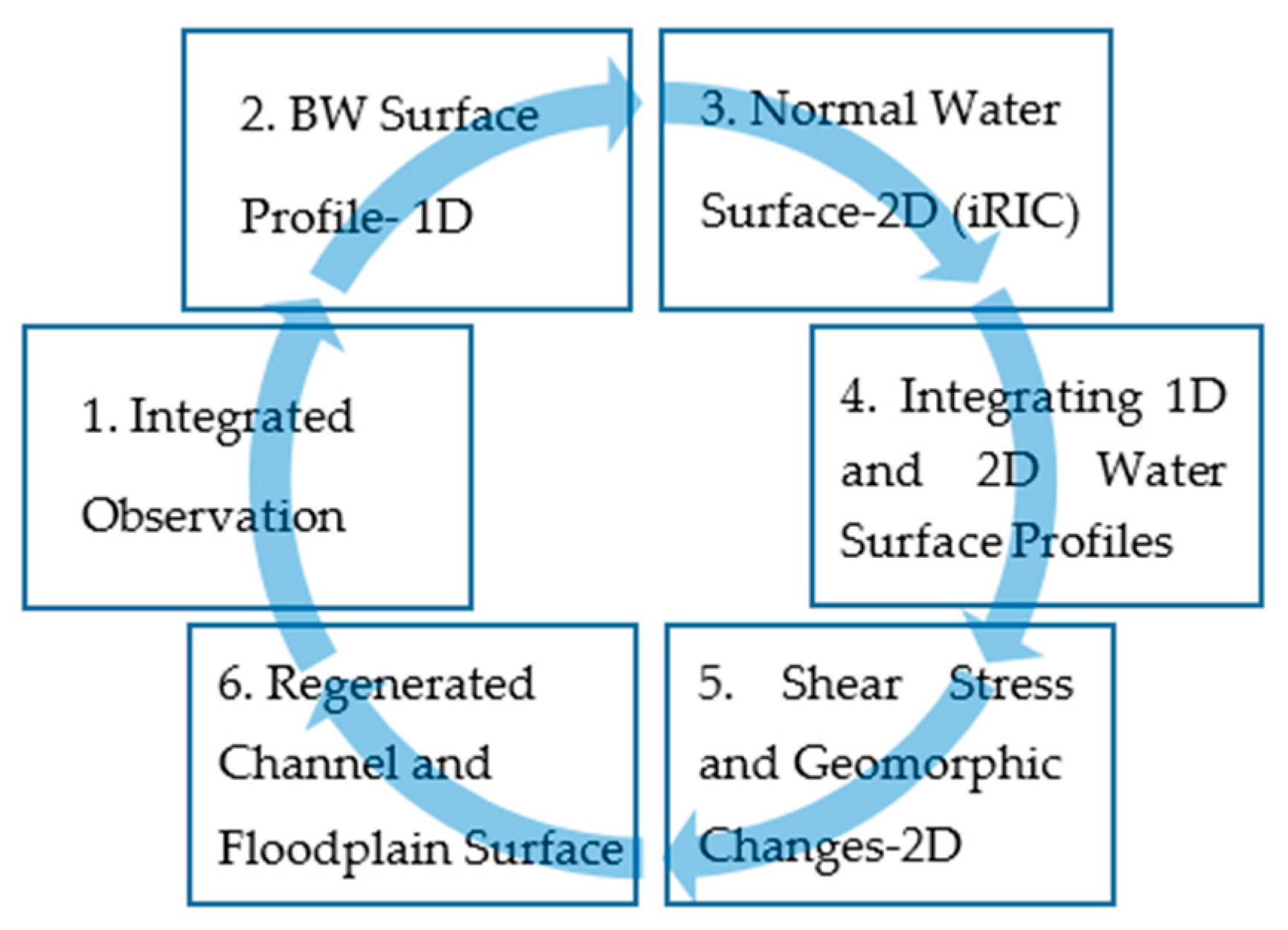
2.2. Integrated Model
- (1)
- The International River Interface Cooperative Hydraulic Model (iRIC) was used to simulate WSE in the normal zone for a specific discharge.
- (2)
- A 1D water surface profile model [43] was used to generate WSE in the BW zone for the same discharge used in step 1.
- (3)
- The water surface profile in the transitional zone was linearly adjusted between the BW and normal zones.
2.3. Data Integration
2.4. Water Surface Profile Generation
2.5. Hydraulic Model Analysis
2.6. Modeling Flood Extent, Frictional Slope, and Shear Stress
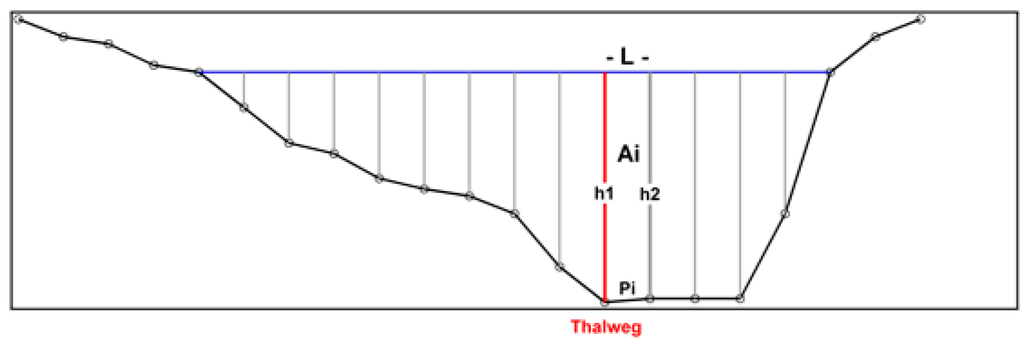
2.7. Geomorphic Analysis
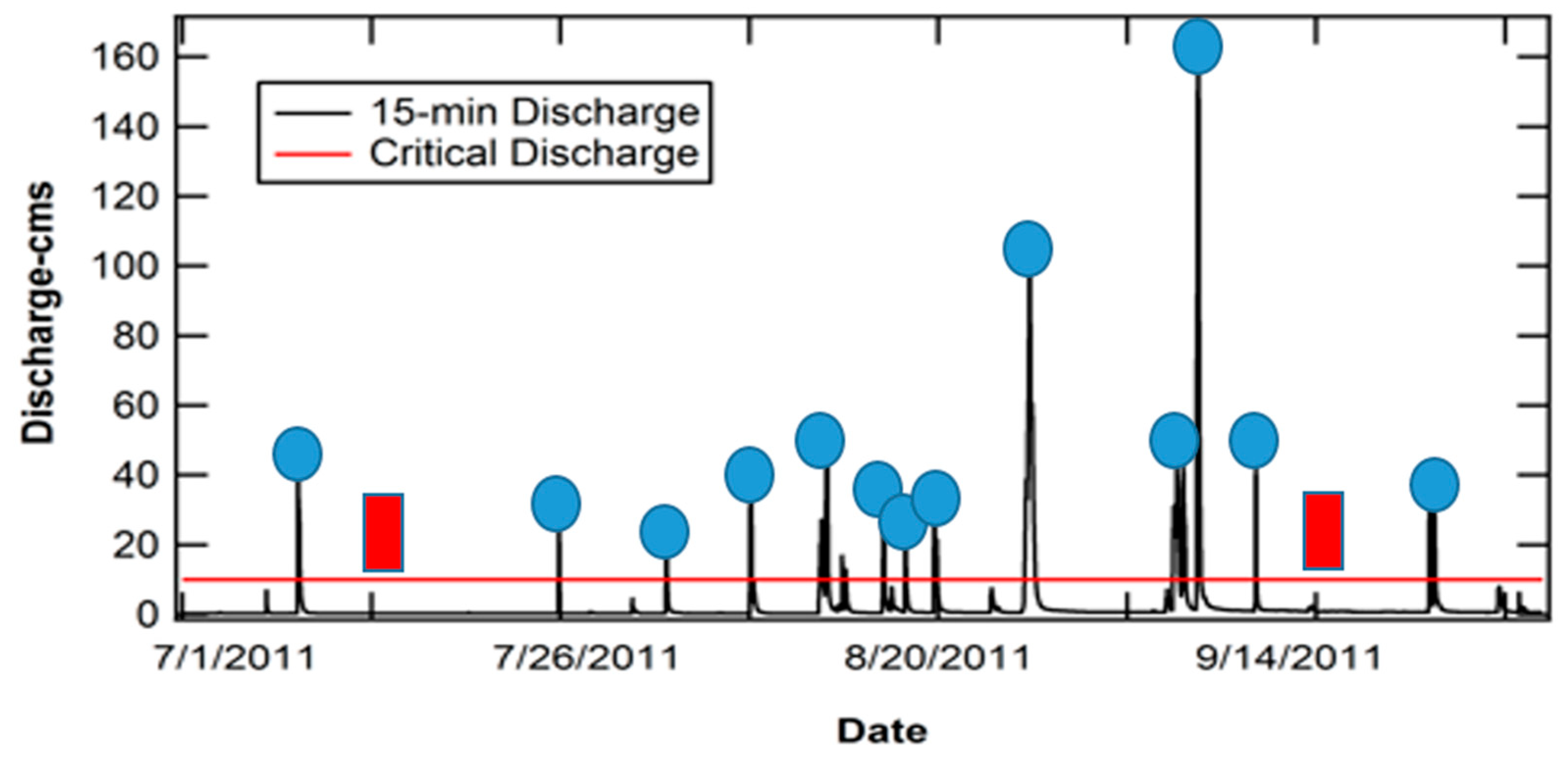
2.8. Iterative Process
2.9. Verification of Geomorphic Model
3. Results and Discussion
3.1. Analysis of Water Surface Elevation
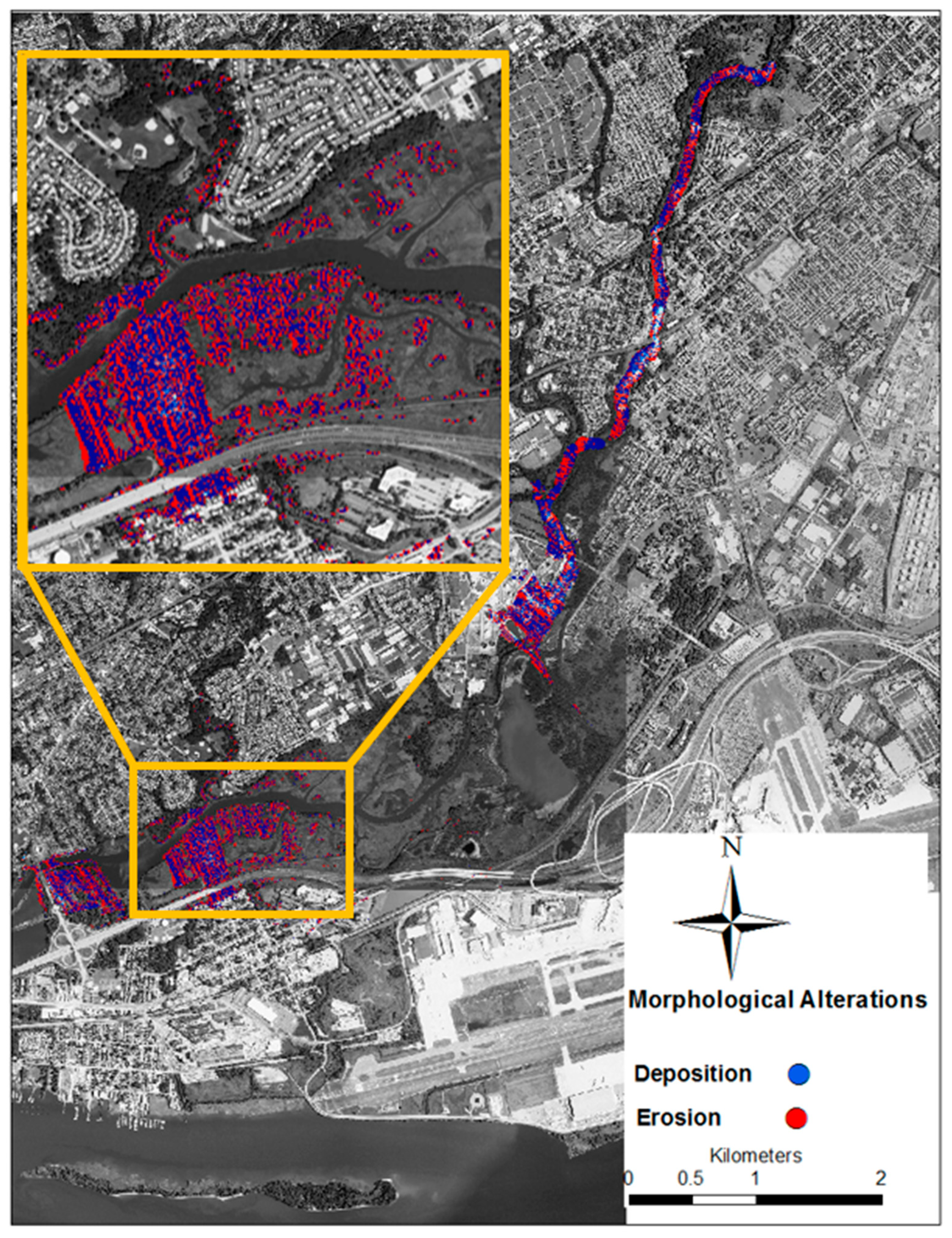
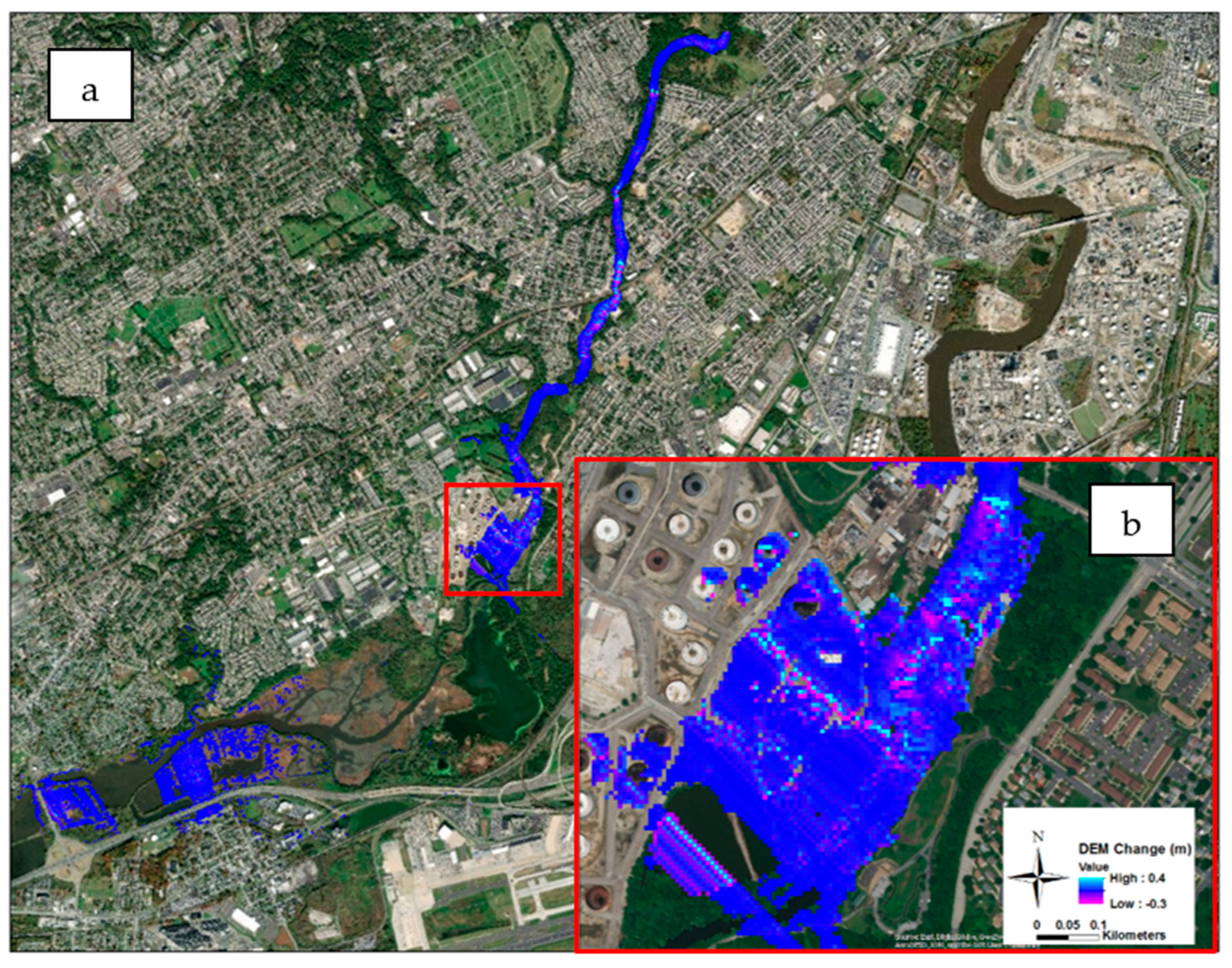
3.2. Analysis of the Geomorphic Model
- (a)
- The presence of water over the land, and that the ground information had not been captured by the satellite images.
- (b)
- A single discharge simulation rather than a full hydrograph did not capture the differences. That means that with regard to morphological alterations, a single discharge might poorly represent a hydrograph.
- (c)
- The vegetation present when the satellite images were captured could cause differences.
- (d)
- The discrepancy between the model and the satellite images also might stem from sensitivity of the model toward the selected sediment size, because it is based on a single grain size. A sensitivity analysis was conducted to test the model’s sensitivity to sediment grain size.
- (e)
- The choice of the sediment transport equation used in the model. The integrated model can be enhanced by including other transport models that can address the mobility of different sediment sizes.
4. Conclusions
Author Contributions
Funding
Acknowledgments
Conflicts of Interest
References
- National Oceanic and Atmospheric Administration. Land-Based Station Data | National Centers for Environmental Information (NCEI) Formerly Known as National Climatic Data Center (NCDC). Available online: https://www.ncdc.noaa.gov/data-access/land-based-station-data/land-based-datasets (accessed on 10 May 2019).
- Census Urban and Rural Classification and Urban Area Criteria. 2010. Available online: https://www.census.gov/geo/reference/ua/urban-rural-2010.html (accessed on 26 March 2019).
- Creel, L. Ripple Effects: Population and Costal Regions; Population Reference Bureau, Making the Link: Washington, DC, USA, 2003; pp. 1–8. [Google Scholar]
- Kummu, M.; De Moel, H.; Salvucci, G.; Viviroli, D.; Ward, P.J.; Varis, O. Over the Hills and Further Away from Coast: Global Geospatial Patterns of Human and Environment over the 20th–21st Centuries. Environ. Res. Lett. 2016, 11, 034010. [Google Scholar] [CrossRef]
- Neumann, B.; Vafeidis, A.T.; Zimmermann, J.; Nicholls, R.J. Future Coastal Population Growth and Exposure to Sea-Level Rise and Coastal Flooding—A Global Assessment. PLoS ONE 2015, 10, e0118571. [Google Scholar] [CrossRef] [PubMed]
- Desmet, K.; Kopp, R.E.; Kulp, S.A.; Nagy, D.K.; Oppenheimer, M.; Rossi-hansberg, E.; Strauss, B.H. Evaluating the Economic Cost of Coastal Flooding; National Bureau of Economic Research Working paper No. 24918; National Bureau of Economic: Cambridge, MA, USA, 2018. [Google Scholar]
- Yang, Y.; Zhang, M.; Zhu, L.; Liu, W.; Han, J.; Yang, Y. Influence of Large Reservoir Operation on Water-Levels and Flows in Reaches below Dam: Case Study of the Three Gorges Reservoir. Sci. Rep. 2017, 7, 1–14. [Google Scholar] [CrossRef] [PubMed]
- Volke, M.A.; Johnson, W.C.; Dixon, M.D.; Scott, M.L. Emerging Reservoir Delta-Backwaters: Biophysical Dynamics and Riparian Biodiversity. Ecol. Monogr. 2019, 89, 1–22. [Google Scholar] [CrossRef]
- Liro, M. Dam Reservoir Backwater as a Field-Scale Laboratory of Human-Induced Changes in River Biogeomorphology: A Review Focused on Gravel-Bed Rivers. Sci. Total Environ. 2019, 651, 2899–2912. [Google Scholar] [CrossRef] [PubMed]
- Fencl, J.S.; Mather, M.E.; Costigan, K.H.; Daniels, M.D. How Big of an Effect Do Small Dams Have? Using Geomorphological Footprints to Quantify Spatial Impact of Low-Head Dams and Identify Patterns of across-Dam Variation. PLoS ONE 2015, 10, 1–22. [Google Scholar] [CrossRef]
- Maselli, V.; Pellegrini, C.; Del Bianco, F.; Mercorella, A.; Nones, M.; Crose, L.; Guerrero, M.; Nittrouer, J.A. River Morphodynamic Evolution Under Dam-Induced Backwater: An Example from the Po River (Italy). J. Sediment. Res. 2018, 88, 1190–1204. [Google Scholar] [CrossRef]
- Chow, V.T. Open-Channel Hydraulics. In Ven Te Chow; McGraw-Hill: New York, NY, USA, 1959. [Google Scholar]
- Dingman, S.L. Fluvial Hydrology; W.H. Freeman and Company: New York, NY, USA, 1984. [Google Scholar]
- Jin, Z.W.; Lu, J.Y.; Wu, H.L. Study of Bedload Transport in Backwater Flow. J. Hydrodyn. 2016, 28, 153–161. [Google Scholar] [CrossRef]
- Xu, J. Evolution of Mid-Channel Bars in a Braided River and Complex Response to Reservoir Construction: An Example from the Middle Hanjiang River, China. Earth Surf. Process. Landf. 1997, 22, 953–965. [Google Scholar] [CrossRef]
- Xu, J. Modified Conceptual Model for Predicting the Tendency of Alluvial Channel Adjustment Induced by Human Activities. Chin. Sci. Bull. 2001, 46, 51–56. [Google Scholar] [CrossRef]
- Munier, S.; Litrico, X.; Belaud, G.; Malaterre, P.O. Distributed Approximation of Open-Channel Flow Routing Accounting for Backwater Effects. Adv. Water Resour. 2008, 31, 1590–1602. [Google Scholar] [CrossRef]
- LU, Y.; ZUO, L.; JI, R.; LIU, H. Deposition and Erosion in the Fluctuating Backwater Reach of the Three Gorges Project after Upstream Reservoir Adjustment. Int. J. Sediment Res. 2010, 25, 64–80. [Google Scholar] [CrossRef]
- Hidayat, H.; Vermeulen, B.; Sassi, M.G.; Torfs, P.J.J.F.; Hoitink, A.J.F. Discharge Estimation in a Backwater Affected Meandering River. Hydrol. Earth Syst. Sci. 2011, 15, 2717–2728. [Google Scholar] [CrossRef]
- Liro, M. Development of Sediment Slug Upstream from the Czorsztyn Reservoir (Southern Poland) and Its Interaction with River Morphology. Geomorphology 2016, 253, 225–238. [Google Scholar] [CrossRef]
- Liro, M. Dam-Induced Base-Level Rise Effects on the Gravel-Bed Channel Planform. Catena 2017, 153, 143–156. [Google Scholar] [CrossRef]
- Nittrouer, J.A.; Shaw, J.; Lamb, M.P.; Mohrig, D. Spatial and Temporal Trends for Water-Flow Velocity and Bed-Material Sediment Transport in the Lower Mississippi River. Bull. Geol. Soc. Am. 2012, 124, 400–414. [Google Scholar] [CrossRef]
- Chow, V.T. Open Channel Hydraulics; The Blackburn Press: Caldwell, NJ, USA, 1959. [Google Scholar]
- Chatanantavet, P.; Lamb, M.P.; Nittrouer, J.A. Backwater Controls of Avulsion Location on Deltas. Geophys. Res. Lett. 2012, 39, 2–7. [Google Scholar] [CrossRef]
- Fernandes, A.M.; Törnqvist, T.E.; Straub, K.M.; Mohrig, D. Connecting the Backwater Hydraulics of Coastal Rivers to Fluviodeltaic Sedimentology and Stratigraphy. Geology 2016, 44, 979–982. [Google Scholar] [CrossRef]
- Lamb, M.P.; Nittrouer, J.A.; Mohrig, D.; Shaw, J. Backwater and River Plume Controls on Scour Upstream of River Mouths: Implications for Fluvio-Deltaic Morphodynamics. J. Geophys. Res. Earth Surf. 2012, 117, 1–16. [Google Scholar] [CrossRef]
- Zhang, X.; Jin, D.; Lu, X.H. Friction Velocity in Decelerating Open Channel Flow. Huazhong Univ. Sci. Technol. 2014, 42, 113–118. [Google Scholar]
- Mohrig, D.; Paola, C. Palaeohydraulics Revisited: Palaeoscope Estimation in Coarse Grained Braided Rivers. Basin Res. 1996, 8, 243–254. [Google Scholar]
- Trower, E.J.; Ganti, V.; Fischer, W.W.; Lamb, M.P. Erosional Surfaces in the Upper Cretaceous Castlegate Sandstone (Utah, USA): Sequence Boundaries or Autogenic Scour from Backwater Hydrodynamics? Geology 2018, 46, 707–710. [Google Scholar] [CrossRef]
- Durkin, P.R.; Boyd, R.L.; Hubbard, S.M.; Shultz, A.W.; Blum, M.D. Three-Dimensional Reconstruction of Meander-Belt Evolution, Cretaceous Mcmurray Formation, Alberta Foreland Basin, Canada. J. Sediment. Res. 2017, 87, 1075–1099. [Google Scholar] [CrossRef]
- Ganti, V.; Lamb, M.P.; Chadwick, A.J. Autogenic Erosional Surfaces in Fluvio-Deltaic Stratigraphy from Floods, Avulsions, and Backwater Hydrodynamics. J. Sediment. Res. 2019, 89, 815–832. [Google Scholar] [CrossRef]
- Chadwick, A.J.; Lamb, M.P.; Moodie, A.J.; Parker, G.; Nittrouer, J.A. Origin of a Preferential Avulsion Node on Lowland River Deltas. Geophys. Res. Lett. 2019, 46, 4267–4277. [Google Scholar] [CrossRef] [Green Version]
- Ganti, V.; Chadwick, A.J.; Hassenruck-Gudipati, H.J.; Fuller, B.M.; Lamb, M.P. Experimental River Delta Size Set by Multiple Floods and Backwater Hydrodynamics. Sci. Adv. 2016, 2, 1–11. [Google Scholar] [CrossRef]
- Blum, M.; Martin, J.; Milliken, K.; Garvin, M. Paleovalley Systems: Insights from Quaternary Analogs and Experiments. Earth Sci. Rev. 2013, 116, 128–169. [Google Scholar] [CrossRef]
- Colombera, L.; Mountney, N.P.; Russell, C.E.; Shiers, M.N.; McCaffrey, W.D. Geometry and Compartmentalization of Fluvial Meander-Belt Reservoirs at the Bar-Form Scale: Quantitative Insight from Outcrop, Modern and Subsurface Analogues. Mar. Pet. Geol. 2017, 82, 35–55. [Google Scholar] [CrossRef]
- Ganti, V.; Chu, Z.; Lamb, M.P.; Nittrouer, J.A.; Parker, G. Testing Morphodynamic Controls on the Location and Frequency of River Avulsions on Fans versus Deltas: Huanghe (Yellow River), China. Geophys. Res. Lett. 2014, 41, 7882–7890. [Google Scholar] [CrossRef]
- Shiers, M.N.; Mountney, N.P.; Hodgson, D.M.; Colombera, L. Controls on the Depositional Architecture of Fluvial Point-Bar Elements in a Coastal-Plain Succession, 1st ed.; Ghinassi, M., Colombera, L., Mountney, N.P., Reesink, A.J.H., Eds.; John Wiley & Sons Ltd.: Cambridge, UK, 2018. [Google Scholar] [CrossRef]
- Martin, J.; Fernandes, A.M.; Pickering, J.; Howes, N.; Mann, S.; Mcneil, K. The Stratigraphically Preserved Signature of Persistent Backwater Dynamics in a Large Paleodelta System: The Mungaroo Formation, North West Shelf, Australia. J. Sediment. Res. 2018, 88, 850–872. [Google Scholar] [CrossRef]
- Zarzar, C.M.; Hosseiny, H.; Siddique, R.; Gomez, M.; Smith, V.; Mejia, A.; Dyer, J. A Hydraulic MultiModel Ensemble Framework for Visualizing Flood Inundation Uncertainty. JAWRA J. Am. Water Resour. Assoc. 2018, 54, 807–819. [Google Scholar] [CrossRef]
- Bauer, M.; Dostal, T.; Krasa, J.; Jachymova, B.; David, V.; Devaty, J.; Strouhal, L.; Rosendorf, P. Risk to Residents, Infrastructure, and Water Bodies from Flash Floods and Sediment Transport. Environ. Monit. Assess. 2019, 191, 85. [Google Scholar] [CrossRef] [PubMed]
- Philadelphia City Council Hearing Testimony on Behalf of Clean Air Council, Clean Water Action. Available online: https://www.pubintlaw.org/wp-content/uploads/2012/06/Environmental-Groups-Testimony.pdf (accessed on 10 May 2019).
- National Wildlife Refuge System. John Heinz National Wildlife Refuge at Tinicum Habitat Management Plan July 2009; U.S. Fish and Wildlife Service: Philadelphia, PA, USA, 2009.
- Parker, G. 1D Sediment Transport Morphodynamics with Applications to Rivers and Turbidity Currents: E-Book; St. Anthony Falls Laboratory, University of Minnesota: Minneapolis, MN, USA, 2004. [Google Scholar]
- Pennsylvania Spatial Data Access Data Summary. Available online: http://www.pasda.psu.edu/uci/DataSummary.aspx?dataset=1248 (accessed on 12 October 2018).
- Pennsylvania Spatial Data Access Data Summary. Available online: http://www.pasda.psu.edu/uci/DataSummary.aspx?dataset=1048 (accessed on 12 October 2018).
- Bathymetric Data Viewer. Available online: https://maps.ngdc.noaa.gov/viewers/bathymetry/ (accessed on 12 October 2018).
- USGS Current Conditions for USGS 01475548 Cobbs Creek at Mt. Moriah Cemetery, Philadelphia. Available online: https://nwis.waterdata.usgs.gov/pa/nwis/uv/?cb_00065=on&cb_00060=on&format=gif_default&site_no=01475548&period=&begin_date=2014-04-29&end_date=2014-04-30 (accessed on 12 October 2018).
- Marcus Hook, PA—NOAA Tides and Currents 8540433. Available online: https://tidesandcurrents.noaa.gov/ports/ports.html?id=8540433 (accessed on 10 May 2019).
- Philadelphia, PA—NOAA Tides and Currents 8545240. Available online: https://tidesandcurrents.noaa.gov/ports/ports.html?id=8545240&mode=allwater (accessed on 10 May 2019).
- EarthExplorer—Home. Available online: https://earthexplorer.usgs.gov/ (accessed on 10 May 2019).
- Ackerman, A.; Thornton, F.; Furth, J.; Cannan, D.; Frasch, B.; Hunt, C.; Simcox, D. Darby Creek Watershed Conservation Plan; Darby Creek Valley Association: Drexel Hill, PA, USA, 2005. [Google Scholar]
- Stormwater Management Plan. Darby and Cobbs Creek Watershed Act 167; Borton-Lawson Engineering Inc.: Wilkes-Barre, PA, USA, 2005. [Google Scholar]
- Nelson, J.M. FaSTMECH Model Notes; U.S. Geological Survey: Lakewood, CO, USA, 2016.
- French, R.H. Open Channel Hydraulics; Water Resources Publication: Highlands Ranch, CO, USA, 2007. [Google Scholar]
- MATLAB R2018a; The Mathworks, Inc.: Natick, MA, USA, 2018.
- Smith, V.; Mohrig, D.; Mason, J. Quantifying and Describing Channel Morphology of the Coastal Backwater: The Lower Trinity River, Texas, USA. In The Geological Society of America Annual Meeting; The Geological Society of America: Denver, CO, USA, 2016. [Google Scholar]
- Strom, K.; Hosseiny, H.; Wang, K.H. Sediment Sampling, Characterization, and Analysis on the Guadalupe River in the Coastal Plain of Texas; University of Houston, Department of Civil and Environmental Engineering: Houston, TX, USA, 2015. [Google Scholar]
- Strom, K.; Hosseiny, H. Suspended Sediment Sampling and Annual Sediment Yield on the Middle Trinity River; University of Houston, Department of Civil and Environmental Engineering: Houston, TX, USA, 2015. [Google Scholar]
- Slingerland, R.L.; Furlong, K.; Harbaugh, J. Delivery of Sediment to Basins by Fluvial Systems. In Simulating Clastic Sedimentary Basins/Physical Fundamentals and Computing Procedures; Prentice Hall: Englewood Clifss, NJ, USA, 1994; p. 15. [Google Scholar]
- Meyer-Peter, E.; Müller, R. Formulas for Bed Load Transport. In 2nd Meeting, Int. Assoc. for Hydroaul. Environ. Eng. and Res.; IAHR: Madrid, Spain, 1948; pp. 39–64. [Google Scholar]
- Huang, H.Q. Reformulation of the Bed Load Equation of Meyer-Peter and Müller in Light of the Linearity Theory for Alluvial Channel Flow. Water Resour. Res. 2010, 46, 1–11. [Google Scholar] [CrossRef]
- Garcia, M. (Ed.) Sedimentation Engineering: Processes, Measurements, Modeling, and Practice; ASCE: Reston, VA, USA, 2007. [Google Scholar]
- Wiberg, P.; Smith, D. Model for Calculating Bed Load Transport of Sediment. J. Hydraul. Eng. 1989, 115, 101–123. [Google Scholar] [CrossRef]
- Smith, V.B.; Mohrig, D. Geomorphic Signature of a Dammed Sandy River: The Lower Trinity River Downstream of Livingston Dam in Texas, USA. Geomorphology 2017, 297, 122–136. [Google Scholar] [CrossRef]
- Liang, M.; Voller, V.R.; Paola, C. A Reduced-Complexity Model for River Delta Formation—Part 1: Modeling Deltas with Channel Dynamics. Earth Surf. Dyn. 2015, 3, 67–86. [Google Scholar] [CrossRef]
- Klein, I.; Gessner, U.; Dietz, A.J.; Kuenzer, C. Global WaterPack—A 250 m Resolution Dataset Revealing the Daily Dynamics of Global Inland Water Bodies. Remote Sens. Environ. 2017, 198, 345–362. [Google Scholar] [CrossRef]
- Dhakal, A.S.; Amada, T.; Aniya, M.; Sharma, R.R. Detection of Areas Associated with Flood and Erosion Caused by a Heavy Rainfall Using Multitemporal Landsat TM Data. Photogramm. Eng. Remote Sens. 2002, 68, 233–239. [Google Scholar]
- Vrieling, A. Satellite Remote Sensing for Water Erosion Assessment: A Review. Catena 2006, 65, 2–18. [Google Scholar] [CrossRef]
- Asahi, K.; Shimizu, Y.; Nelson, J.; Parker, G. Numerical Simulation of River Meandering with Self-Evolving Banks. J. Geophys. Res. Earth Surf. 2013, 118, 2208–2229. [Google Scholar] [CrossRef]
- U.S. Landsat Analysis Ready Data (ARD) | Landsat Missions. Available online: https://landsat.usgs.gov/ard (accessed on 1 February 2019).
- Schoklitsch, A. Handbuch Des Wasserbaue; Springer: New York, NY, USA, 1950. [Google Scholar]
- ESRI 2018. ArcGIS Desktop: Release 10; Environmental Systems Research Institute: Redlands, CA, USA, 2018. [Google Scholar]
- Gao, B. NDWI—A Normalized Difference Water Index for Remote Sensing of Vegetation Liquid Water from Space. Remote Sens. Environ. 1996, 58, 257–266. [Google Scholar] [CrossRef]
- Mcfeeters, S.K. The Use of the Normalized Difference Water Index (NDWI) in the Delineation of Open Water Features. Int. J. Remote Sens. 1996, 17, 1425–1432. [Google Scholar] [CrossRef]
- Weber, M.D.; Pasternack, G.B. Valley-Scale Morphology Drives Differences in Fluvial Sediment Budgets and Incision Rates during Contrasting Flow Regimes. Geomorphology 2017, 288, 39–51. [Google Scholar] [CrossRef]
- Wyrick, J.R.; Pasternack, G.B. Revealing the Natural Complexity of Topographic Change Processes through Repeat Surveys and Decision-Tree Classification. Earth Surf. Process. Landf. 2016, 41, 723–737. [Google Scholar] [CrossRef]
- Abu-Aly, T.R.; Pasternack, G.B.; Wyrick, J.R.; Barker, R.; Massa, D.; Johnson, T. Effects of LiDAR-Derived, Spatially Distributed Vegetation Roughness on Two-Dimensional Hydraulics in a Gravel-Cobble River at Flows of 0.2 to 20 Times Bankfull. Geomorphology 2013, 206, 468–482. [Google Scholar] [CrossRef]


| Data | Source |
|---|---|
| Basin DEM based on LiDAR (2006–2008) | Pennsylvania Spatial Data Access (PASDA), PAMAP Program [44] |
| LiDAR cloud point (2015) | PASDA, City of Philadelphia [45] |
| Bathymetry (2008) | Bathymetric Data Viewer, NOAA [46] |
| Discharge (2006–2016) and measured water surface elevation (2015) | National Water Information System, USGS [47] |
| Stage | Tides at Marcus Hook [48], Philadelphia, PA—NOAA Tides & [49] |
| Sediment grain size | Collected bed sediment samples |
| Landsat satellite images | USGS Earth Explorer [50] |
© 2019 by the authors. Licensee MDPI, Basel, Switzerland. This article is an open access article distributed under the terms and conditions of the Creative Commons Attribution (CC BY) license (http://creativecommons.org/licenses/by/4.0/).
Share and Cite
Hosseiny, H.; Smith, V. Two Dimensional Model for Backwater Geomorphology: Darby Creek, PA. Water 2019, 11, 2204. https://doi.org/10.3390/w11112204
Hosseiny H, Smith V. Two Dimensional Model for Backwater Geomorphology: Darby Creek, PA. Water. 2019; 11(11):2204. https://doi.org/10.3390/w11112204
Chicago/Turabian StyleHosseiny, Hossein, and Virginia Smith. 2019. "Two Dimensional Model for Backwater Geomorphology: Darby Creek, PA" Water 11, no. 11: 2204. https://doi.org/10.3390/w11112204