1. Introduction
Water resources are planned and regulated on a river basin scale so that the future design and evaluation of management practices depend on the total hydrologic and biogeochemical performance of the basin instead of singular hydrologic units [
1,
2,
3]. Watershed models are approaches to predict water quantity and quality of a basin accounting for complete physical, chemical, and biological processes [
4]. Large-scale watersheds, such as the Upper Mississippi River Basin (UMRB), are complex systems that need physically-based and distributed watershed models to simulate their hydrological and biogeochemical functions [
5]. Many watershed models are designed particularly at a large spatial scale with respect to their model structures including temporal and spatial discretization schemes, physical functions, and major hydrological and biogeochemical processes [
6,
7]. The Soil and Water Assessment Tool (SWAT) is one of these watershed models designed for simulating long-term water quantity and quality as impacted by land use and climate changes and best management practices at large-scale watersheds [
6]. It is a semiphysical and semidistributed model accounting for major hydrological and biogeochemical processes significant at large spatial scale (small to large watersheds) and medium to large temporal scale (daily to monthly) [
8,
9,
10]. It divides a watershed into sub-basins connected by a stream network and further delineates each sub-basin into hydrologic response units (HRUs), which consist of unique combinations of land cover, slope, and soil type [
8]. The model calculates the water balance (including surface and subsurface runoff, percolation and base flow, and evapotranspiration and transmission losses), crop growth, nutrient cycling, and pesticide movement at the HRU scale [
11,
12]. Water flow, sediment, and nutrient loadings from each HRU in a sub-basin are summed and the resulting loadings are then routed through channels, ponds, and reservoirs to the watershed outlet [
8,
13]. It is so designed that no or minimal calibration efforts may be taken to provide reasonable simulation results at large-scale watersheds given accurate inputs including weather data, topographic and soil characteristics, and land use and management information [
8,
14,
15].
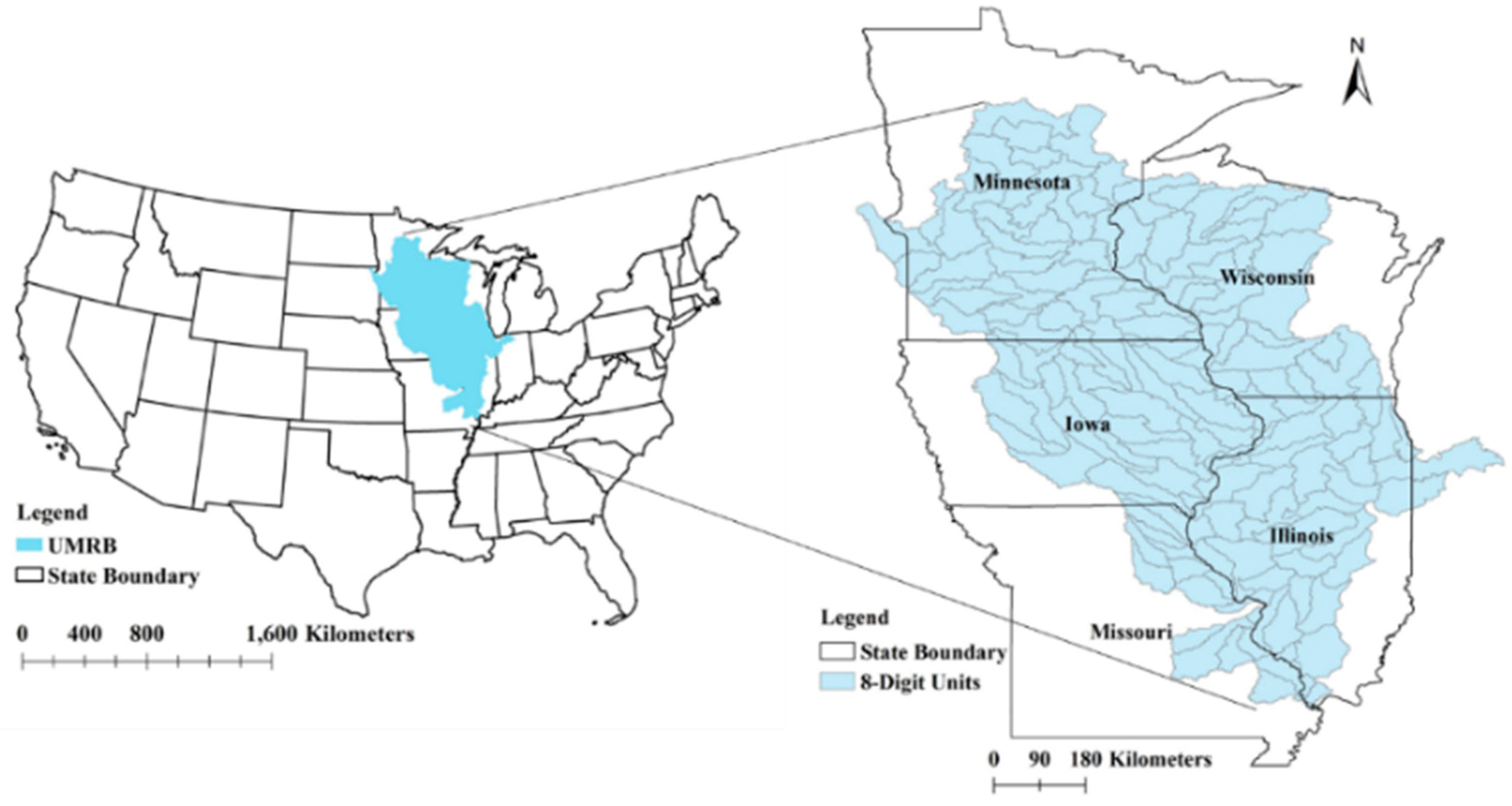
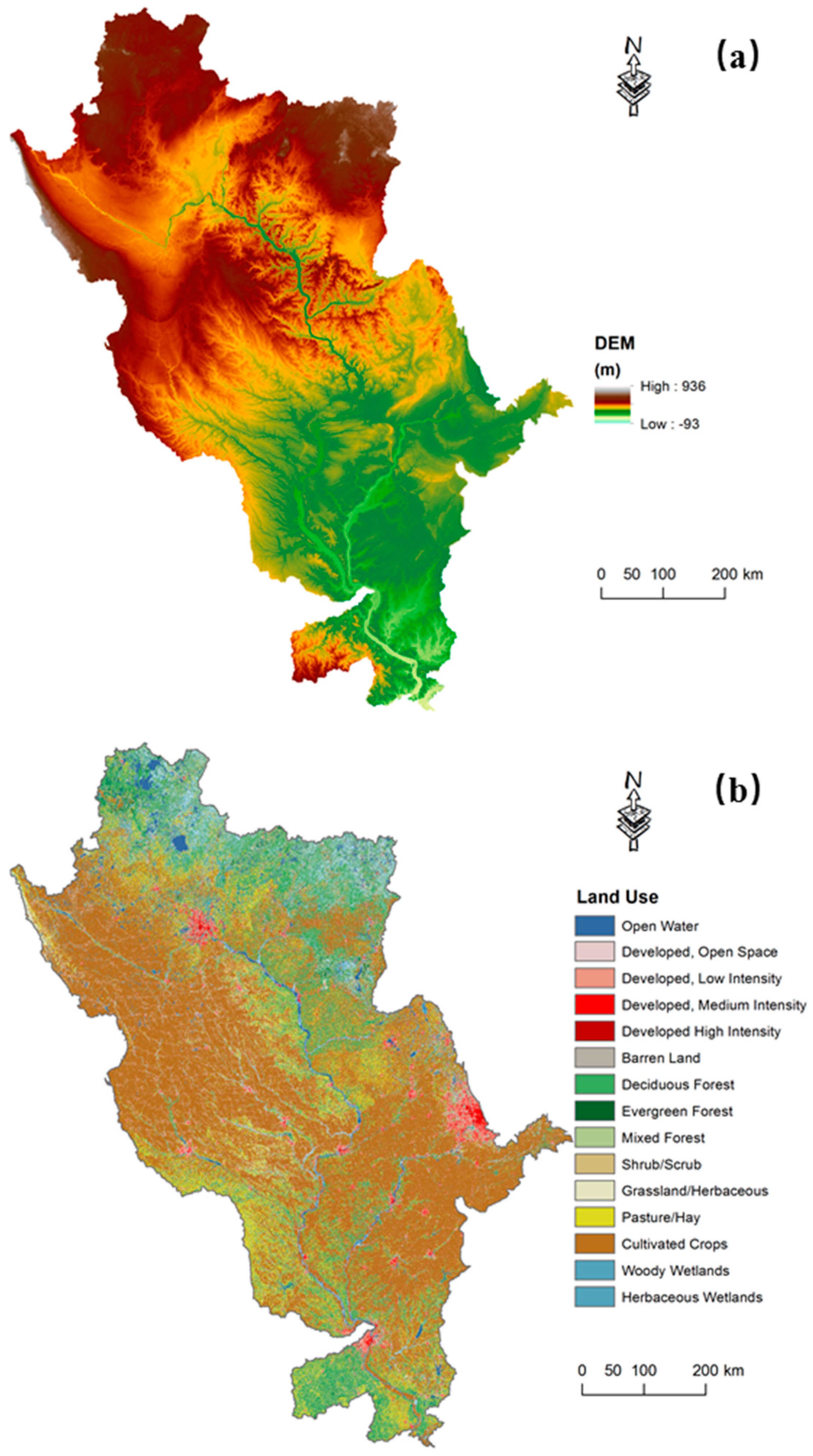
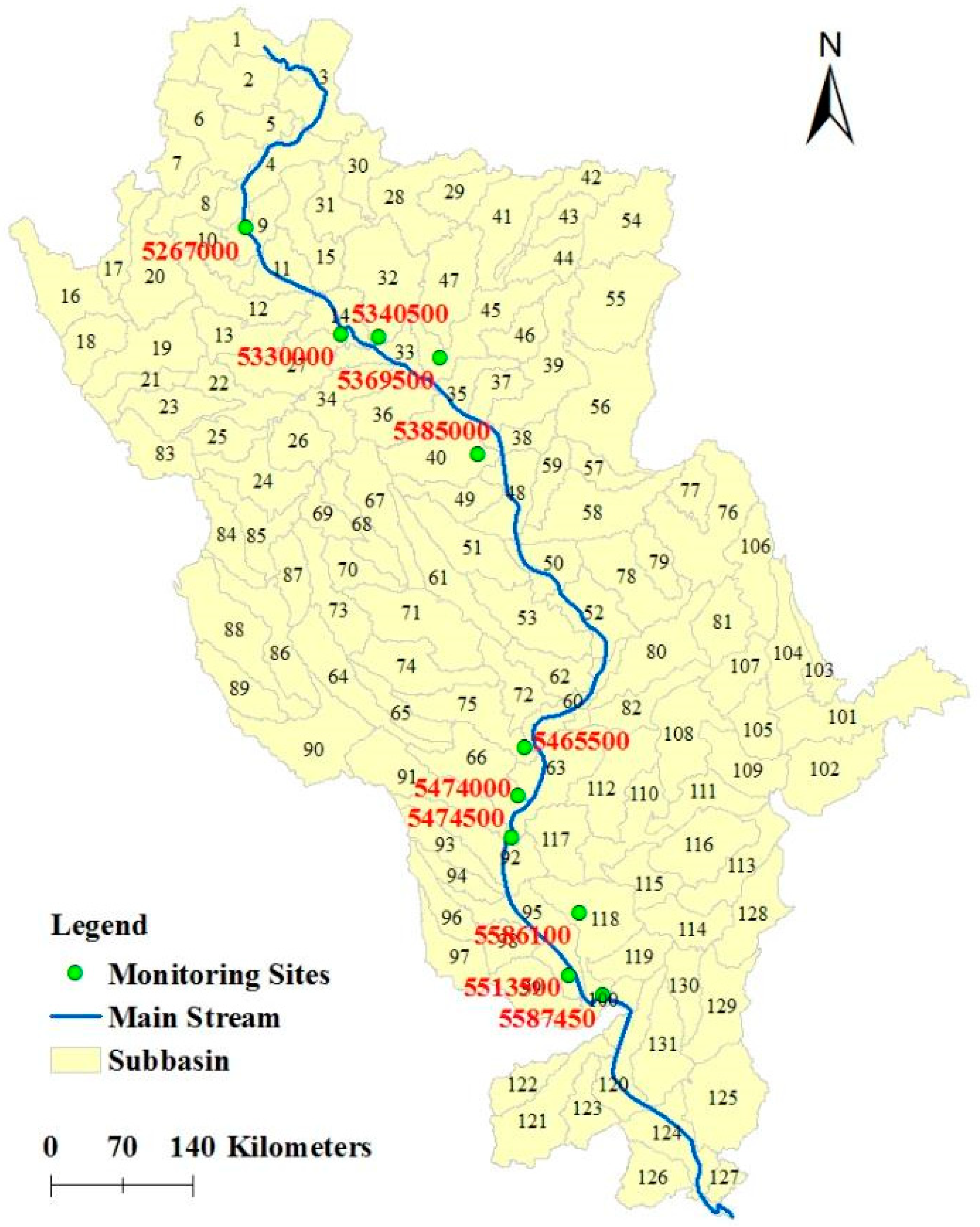
A previous study proposed a framework for developing spatial input data as detailed as possible for SWAT in the UMRB [
16]. The input data include soil, land use, topography, management practices (including tile, tillage, fertilization, crop rotation, etc.), and weather information. The SWAT model was not calibrated, and it was tested directly with stream flow records from USGS monitoring gauges. The study found that the uncalibrated SWAT could satisfactorily predict the UMRB hydrologic budget. The results emphasized the importance of using accurate spatial input data for SWAT application in large-scale watersheds model. Weather data are the key forces that drive hydrological processes on land phase of global cycles so that their accuracy in watershed modeling is fundamentally important [
17,
18]. The previous study used a dataset of daily precipitation and max/min air temperature developed by Di Luzio et al. [
19] via combining daily observations from the National Climatic Data Center (NCDC) digital archives with maps from the Parameter-Elevation Regressions on Independent Slopes Model (PRISM). Then a GIS-based weather interpolation program [
20] was used to aggregate the daily precipitation and max/min air temperature to sub-basins. This type of weather data interpolation methods is widely used for watersheds with sparse monitoring networks and large hydroclimatic gradients [
20,
21,
22,
23]. For large-scale watersheds, it is almost inevitably to use estimated weather data in sub-basins without monitoring data. Studies have shown that spatial precipitation estimated using different interpolation methods can be substantially different from each other [
20]. In order to provide accurate spatial precipitation, it is suggested to implement multiple spatial interpolation methods and select the one with better evaluation coefficients [
20]. In addition, it is time consuming and computational inefficient to process large amount of weather data for large-scale watersheds.
Another option that can be used to provide estimated weather data is usage of assimilated datasets at global gridded points [
18,
24,
25,
26,
27,
28]. There are several assimilated datasets (reanalysis), such as those provided by National Centers for Environmental Predication (NCEP)/National Center for Atmospheric Research (NCAR) and the European Centre for Medium-Range Weather Forecast (ECMWF). These datasets have relatively coarse grid size ranging from 0.125° to 2.5° (15 to 290 km) and different periods of available data. A potential weather data source feasible for UMRB modeling is available through the NASA North American Land Data Assimilation System Phase Two (NLDAS2) [
29,
30]. NLDAS2 climate forcing data have assimilated multiple sources of climate observations and are widely recognized as a high resolution, spatially continuous, and comprehensive dataset that is valuable for watershed scale hydrology modeling [
30]. We used the NLDAS2 dataset based on several considerations: the NLDAS2 dataset can provide all weather parameters required by SWAT including temperature, precipitation, solar radiation, relative humidity, and wind speed data; it has a smaller grid size (15 km) than other assimilated datasets (≥15 km); and it includes a historical coverage parallel to that of USGS monitoring records used in the UMRB.
The objective of this study is to assess the performance of SWAT on stream flow simulation forced by NLDAS2 weather data as comparing to the model performance forced by NCDC-based interpolation weather data in the UMRB. In the present study, we intended to evaluate the applicability of NLDAS2 data used by SWAT in large-scale watersheds like the UMRB.
4. Conclusions
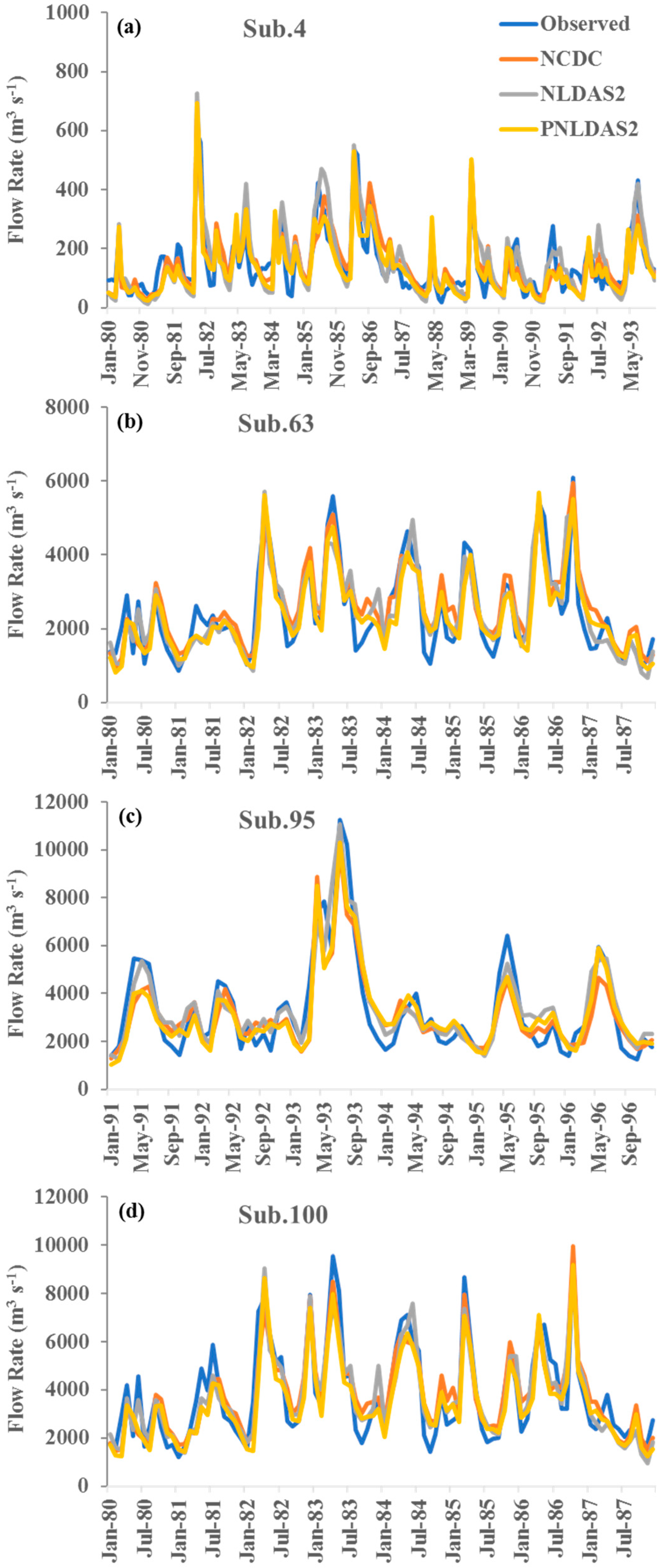
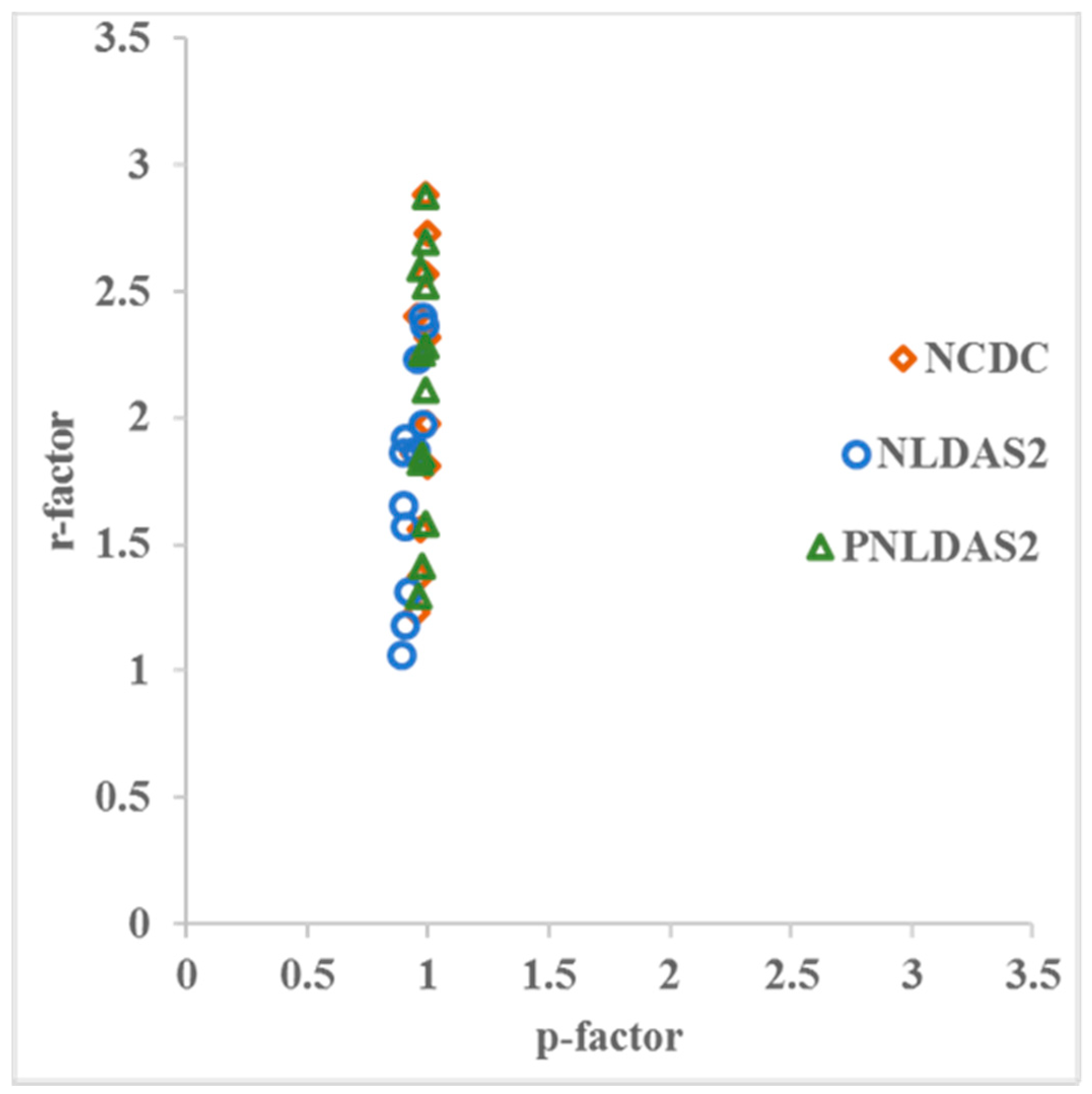
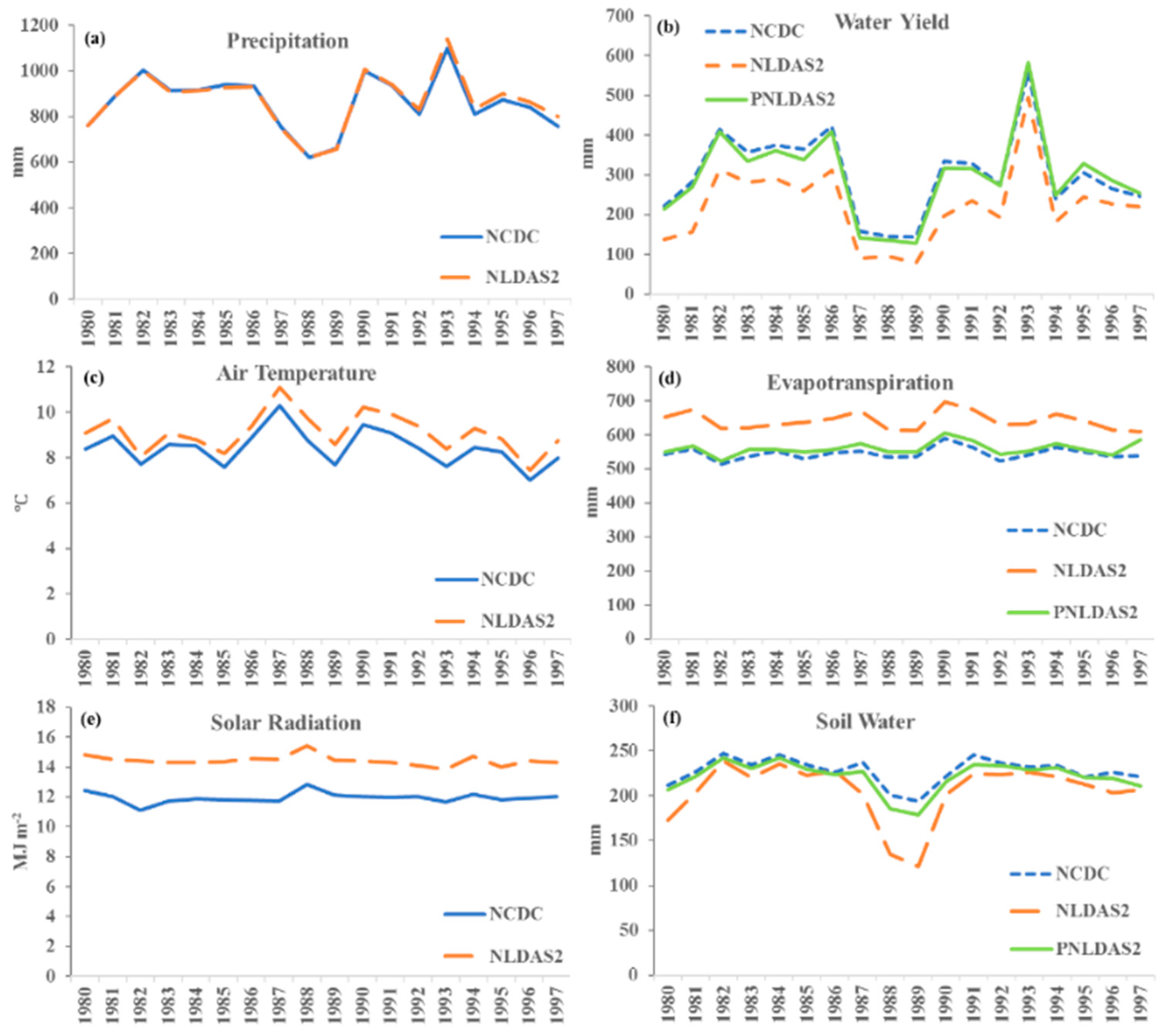
The present study compared interpolation weather data and NASA North American Land Data Assimilation System Phase Two (NLDAS2) weather data used in SWAT application at a large-scale watershed—the Upper Mississippi River Basin (UMRB). Interpolation weather data were derived based on National Climatic Data Center (NCDC) archives. Three scenarios with different weather data input were considered, including NCDC-SWAT, NLDAS2-SWAT, and Partial-NLDAS2-SWAT (PNLDAS2-SWAT). NCDC-SWAT used daily precipitation and max/min air temperature from the NCDC-based interpolation weather data; NLDAS2-SWAT used daily precipitation, max/min air temperature, solar radiation, relative humidity, and wind speed from NLDAS2 data; and PNLDAS2-SWAT used daily precipitation and max/min air temperature from NLDAS2 data, and solar radiation, relative humidity, and wind speed generated by the WXGEN weather generator within SWAT. In the three scenarios, the SWAT model was used to simulate monthly stream flow at 11 USGS monitoring stations in the UMRB. Model performances were evaluated according to three statistics: coefficient of determination (R2), Nash–Sutcliffe coefficient (NS), and percent bias (Pbias), on the monthly temporal scale. We further conducted parameter sensitivity and model uncertainty analyses using the Sequential Uncertainty Fitting algorithm version 2 (SUFI-2) procedure in SWAT-CUP. The results show that the SWAT model compared well at all monitoring stations for stream flow in three scenarios indicating that the SWAT model can adequately produce long-term water yield in UMRB. The results also show that using NLDAS2 weather data can improved SWAT prediction of stream flow with less prediction uncertainty in the UMRB. We concluded that NLDAS2 data can be used by the SWAT model for large-scale watersheds like UMRB as a surrogate of interpolation weather data.
We also conducted a study using uncalibrated SWAT model to simulate monthly stream flow in the UMRB with the three scenarios. The comparison results indicated that NLDAS2 data have higher daily solar radiation than interpolation weather data (the difference is ~2.5 MJ m−2 d−1) and, as a result, the SWAT model underestimated stream flow in the UMRB due to the overestimation of evapotranspiration in the scenario of NLDAS2-SWAT. The implication of the overestimated solar radiation by NLDAS2 should be fully considered when using the uncalibrated SWAT model. We pointed that combining precipitation and temperature from NLDAS2 data with solar radiation generated by SWAT built-in weather generator can be a feasible option for large-scale watershed modeling.


