1. Introduction
Hydrological models are simplified, conceptual representations of the real world water cycle [
1], aiming to analyze, understand and explore the dynamics of hydrological processes. A model consists of various parameters that define the characteristics of the model. Based on the model parameters, hydrological models are classified into lumped and distributed models. While the former category uses lumped parameters for an entire basin and is usually difficult to realistically represent spatiotemporal heterogeneity within a catchment, the latter, generally physically based, takes into account inhomogeneous information fed with spatially discretized units such as the hydrological response unit (HRU) or grid cell [
2]. The distributed models usually require a large number of parameters. Some of the model parameters are measurable but many of them are hard to obtain in a direct manner [
3]. Therefore, parameter calibration techniques have been developed to estimate more suitable parametric values.
Model calibration is usually performed in two steps: sensitivity analysis and parameter calibration. The sensitivity analysis is used to determine how different values of variables will affect the simulation results and figure out the most sensitive parameters, which are subject to further calibration. Some of the commonly used sensitivity analysis methods are the Morris method [
4], the Latin-Hypercube one-factor-at-a-time procedure [
5], the variance-based Sobol method [
6] and extended Fourier amplitude sensitivity testing (eFAST) [
7]. Parameter calibration deals with estimating the values of parameters to achieve optimal simulation. As the relationship in a hydrologic model between the input variables and outputs is highly nonlinear, mathematically it can be solved as an optimization problem. Several well-known parameter calibration techniques for hydrological modeling are, to name a few, the genetic algorithm [
8], shuffled complex evolution algorithm [
9] and particle swarm optimization (PSO) method [
10].
Many works in past years have been done to improve the effectiveness, consistency and efficiency of calibration for hydrologic models. Most of them focus on the following aspects: (i) Improve the calibration method by, for example, introducing a more effective random value method [
11], making it fully automated [
12], or speeding up the computation with parallel operations [
13]; (ii) optimize the search space to better represent catchment characteristics, for example, by confining parameters to finite ranges [
14] or performing calibration for temporally isolated periods [
15]; (iii) define more efficient objectives by, for example, setting multiple objectives for best approximating conventional discharge measures and other available variables [
16]. When additional measures of state variables such as soil moisture [
17] and evapotranspiration (ET) [
18] are available, the inclusion of them as calibration targets is likely to help optimal values.
Modeling in cold alpine basin usually needs to consider more complex situations compared to other regions. A cold alpine basin has a unique hydrological cycle due to the existence of frozen ground and glaciers. The occurrence and distribution of frozen ground strongly affect many hydrological and thermal processes [
19,
20] such as snow melting [
21], soil moisture and temperature, and infiltration capacity [
22]. Meanwhile, the responses of cold region hydrological components to the changing climate [
23,
24] makes modeling more challenging. In the upper Heihe River Basin, a typical cold alpine basin in the Qilian Mountains, Northwest China, many existing hydrological and land surface models have been evaluated for applicability and improved in performance [
25]. Included are empirical models such as the Hydrologiska Byråns Vattenbalansavdelning model [
26], semi-distributed models such as TOPMODEL (a TOPography based hydrological MODEL) [
27] and the Snowmelt Runoff model [
28], distributed models such as Soil and Water Assessment Tool (SWAT) [
29], Distributed Large Basin Runoff model [
30] and Geomorphology-Based Hydrological model [
31], and land surface models such Noah [
32,
33]. They mostly laid stress on the improvement of model physics to adapt to the cold region but overlooked the impacts of spatiotemporal heterogeneity in the cold region on model parameters. The general calibration process is dedicated to find optimal parameter values globally best-fitted over all spatial units and the entire simulation periods in the meanwhile. The obtained parameters are often spatially and temporal invariant. The efforts finding a single set of parameters optimized for all spatial and temporal units could be compromised in particular when the driving forces, surface conditions and soils have distinctive characteristics in space or time.
In a cold alpine basin, the strong seasonality of precipitation may make temporally invariant model parameters hard to represent the real conditions. In recognition of this, some studies have established strategies to calibrate parameters in separate seasons [
15,
34]. Meanwhile, permafrost and seasonally frozen ground (SFG) that are extensively distributed across cold alpine basins have distinctive soil hydrological and thermal properties [
35,
36], and may also strongly impact the parameters representing the basin characteristics [
37,
38]. Therefore, it motivates the investigation of including spatial and temporal stratifications into a calibration scheme, in which both the frozen ground types and precipitation seasonality are considered.
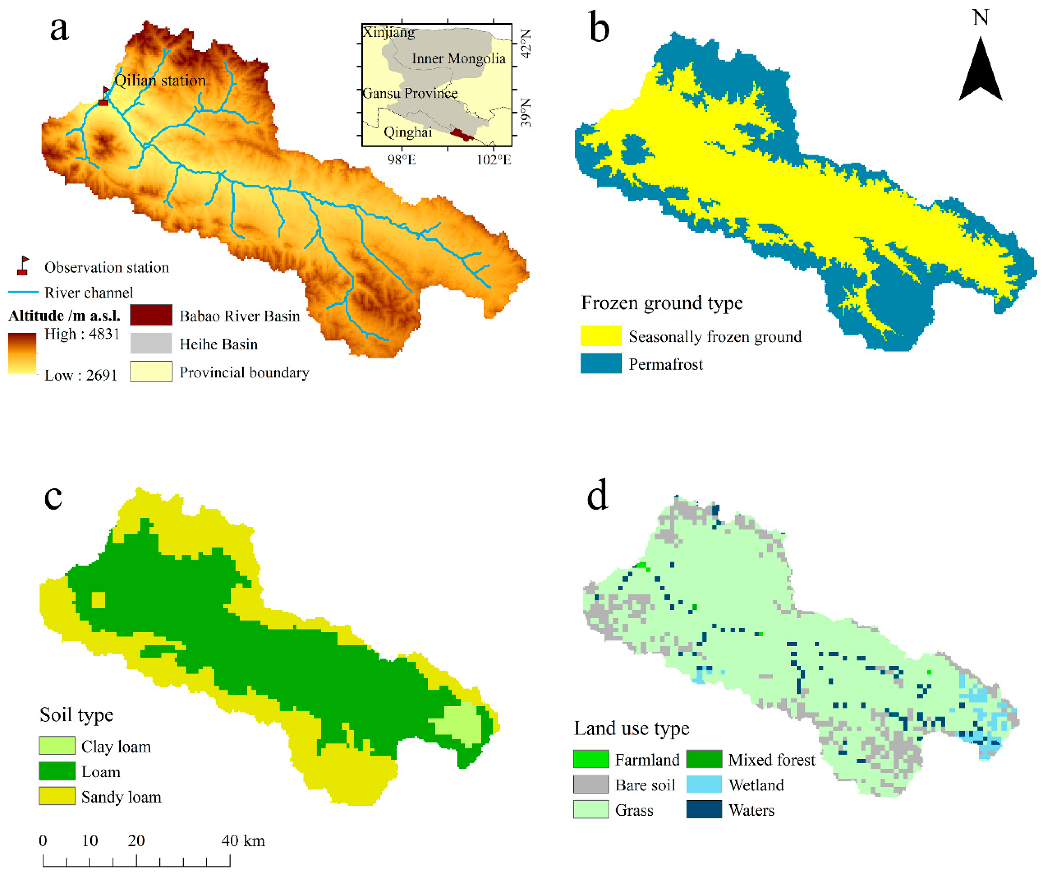
The objective of this study is to develop a new calibration scheme for hydrological modeling in cold alpine basins in which the model parameters are stratified by frozen ground type and season. The approach was evaluated in the Babao River Basin, located within the Qilian Mountains, northwest China, where a grid-based distributed hydrological model, distributed hydrology–soil–vegetation model (DHSVM), was applied. This paper is organized as follows.
Section 2 elaborates the proposed stratified calibration scheme in parallel with the study area, data and the model settings.
Section 3 presents the results from the calibration experiments and examines their impacts on the simulation accuracy.
Section 4 includes a thorough discussion on the effectiveness and rationality of this proposed calibration scheme. The uncertainties and model inadequacy learned through those experiments are also discussed. Finally, the conclusions are drawn in
Section 5.
4. Discussion
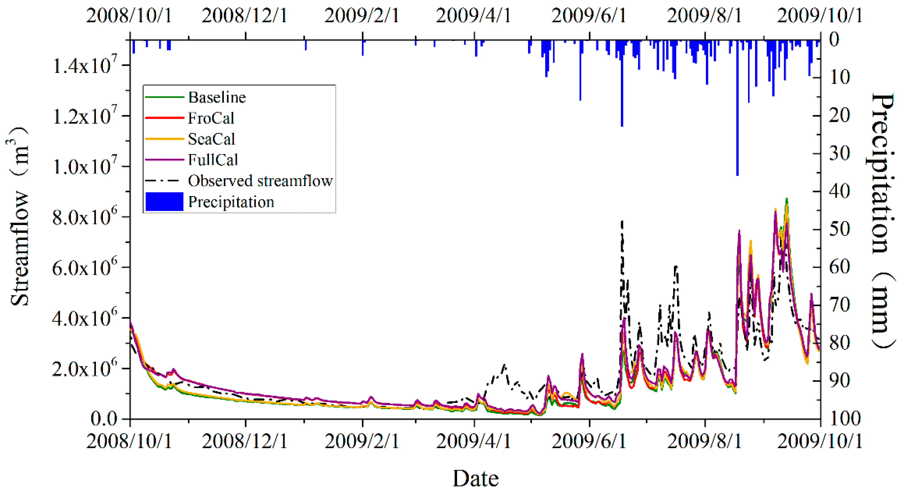
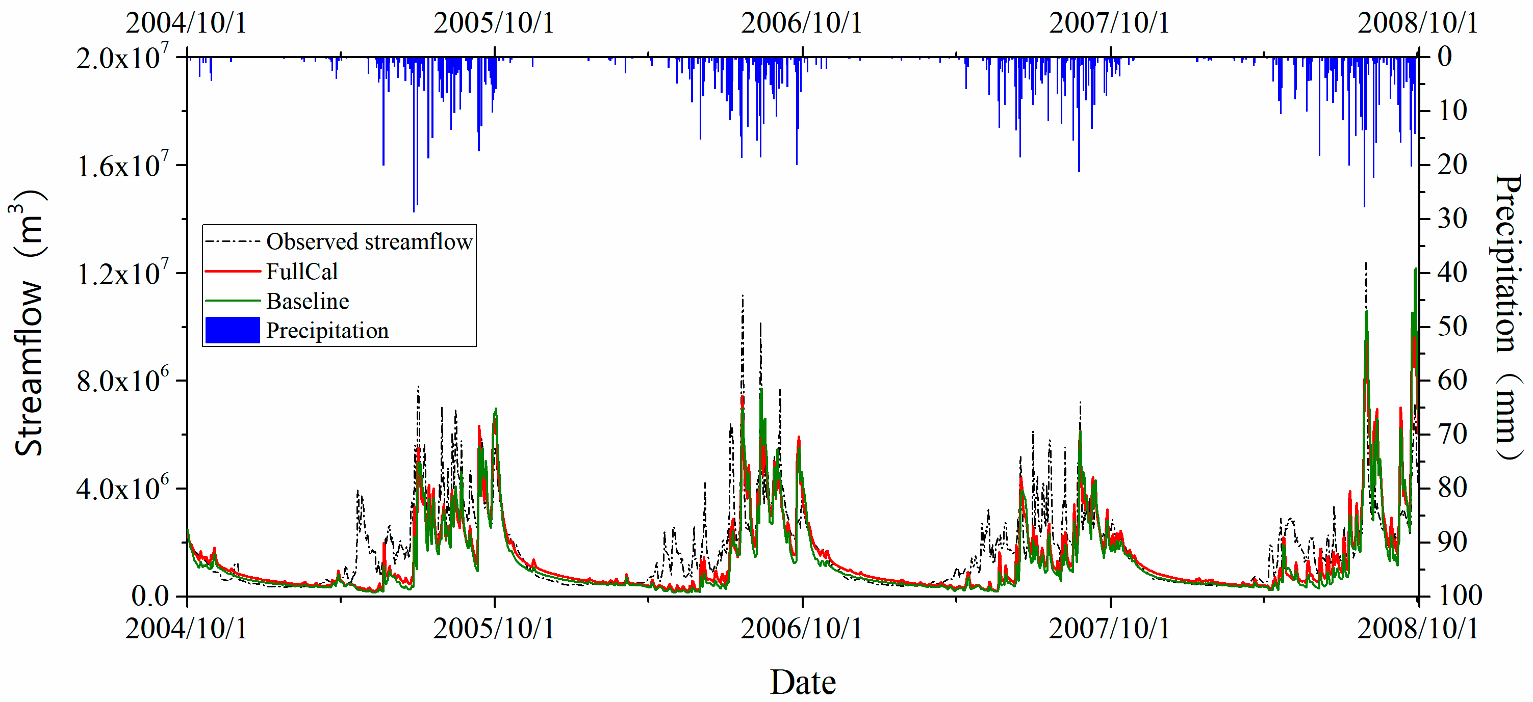
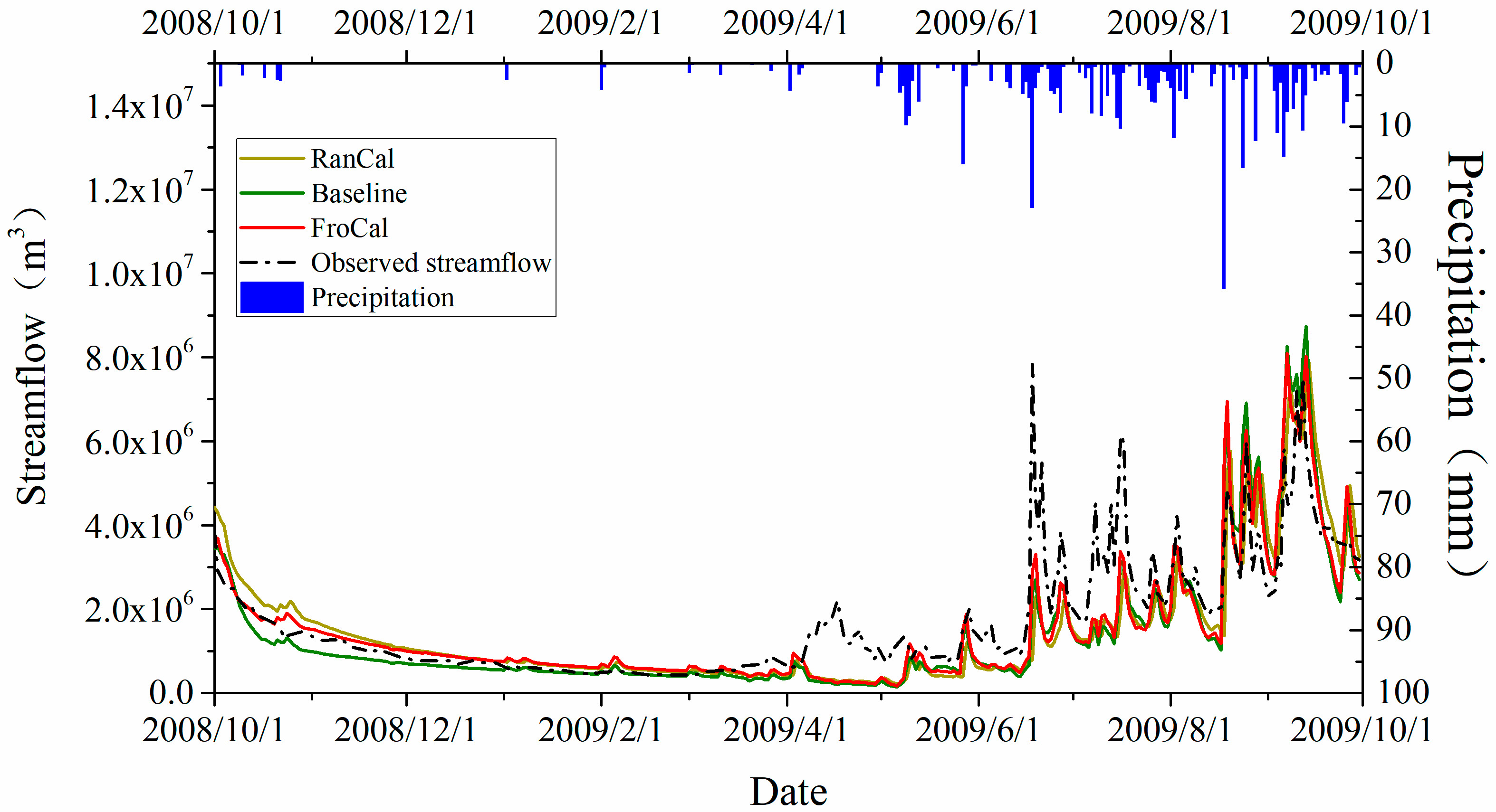
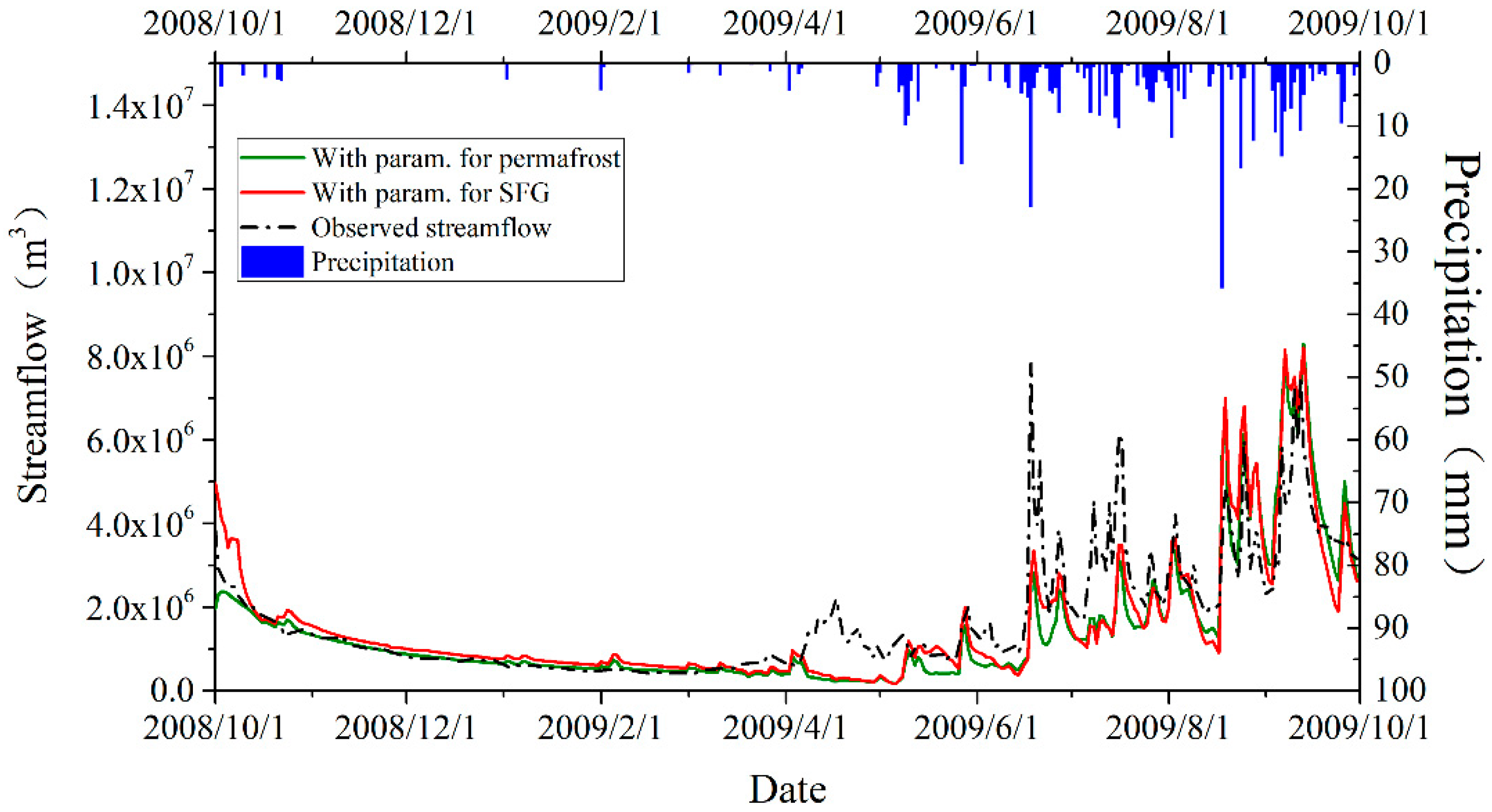
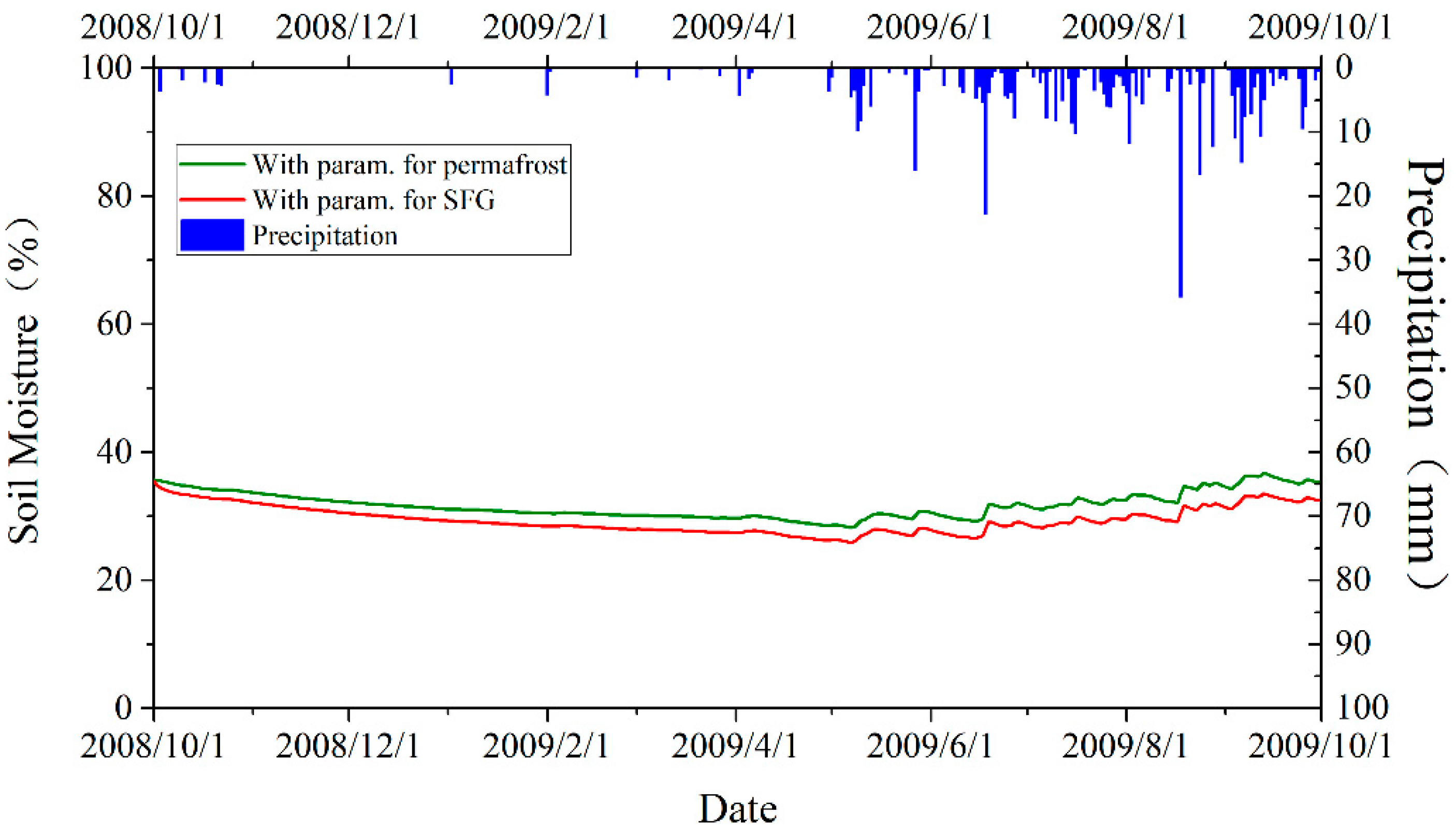
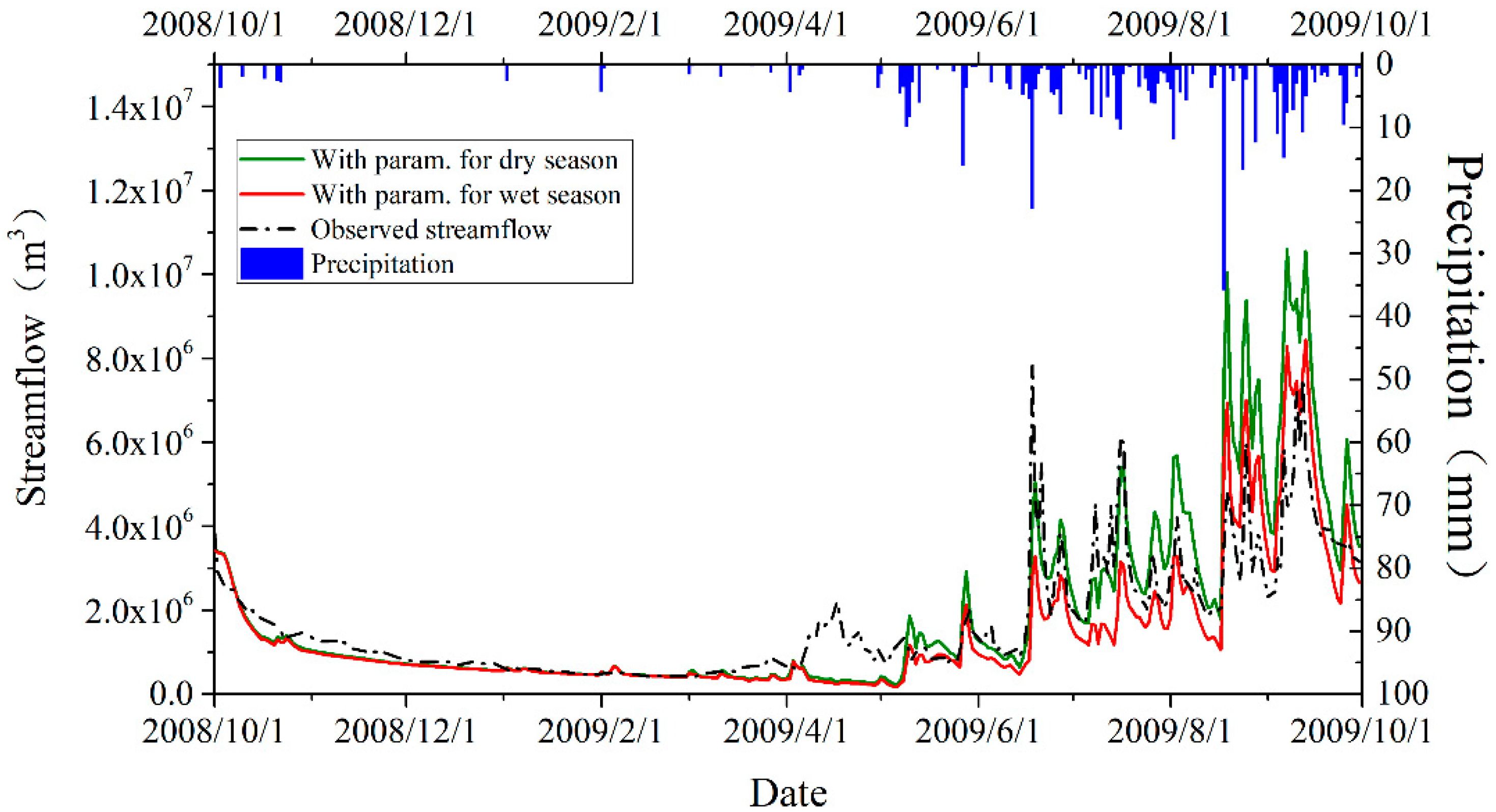
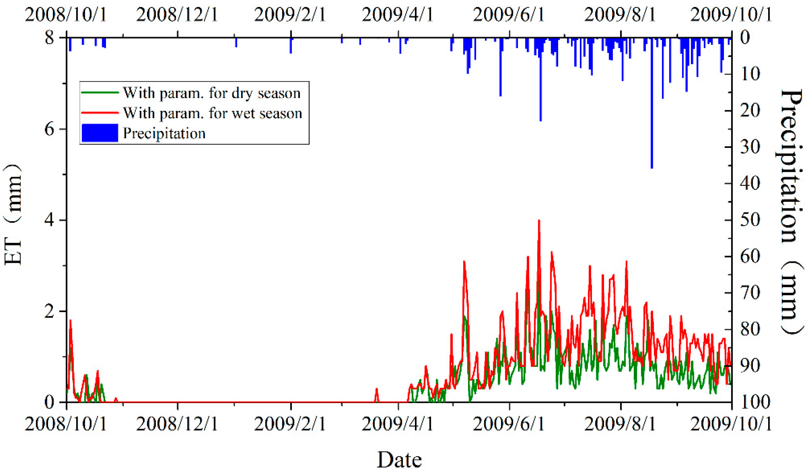
We identified sensitive parameters in the DHSVM as frozen ground type sensitive and season sensitive parameters when simulating in a cold alpine basin. It shows considerable improvement with calibrated parameters by considering both frozen ground type and season stratification (
Figure 3 and
Figure 4). Calibrating with stratified frozen ground types will improve the base flow simulation in particular in dry seasons. In permafrost areas, impermeable frozen soil prevents liquid water from passing down and diminishes the downslope outflow. Such effects do not exist in the SFG areas. As revealed in the hypothetical experiments separately testing the permafrost and the SFG parameters in the entire basin (
Figure 7 and
Figure 8), the optimal parameters for permafrost areas will tend to hold more soil moisture and consequently reduce the base flow. It lays a theoretical basis for necessitating parameter calibration considering spatial stratification by frozen ground type [
35,
36]. To fully test the advantages of such stratification, it is recommended to purposively set up some discharge gauges in permafrost and SFG dominated sub-catchments. In this study, however, there are no such sub-catchment gauges and we instead validated the results at the final outlet of the study basin. The impacts are positive on the simulation results by stratifying parameters by frozen ground type, especially in dry seasons when the base flow plays a leading role. Meanwhile, calibrating in separated dry and wet seasons is likely to ameliorate the simulation of surface runoff in rainfall periods by mainly adapting the parameters in connection to the land cover types. The Babao River Basin is a natural basin with few human interventions. Grassland in the basin shows strong phenology, therefore, model parameters associated with the vegetation type will change across seasons. Furthermore, because most precipitation concentrates on the wet season, moisture conditions on the land surface also affect the model parameters relevant to land cover type. The joint effects are likely to disable a single set of parameters to represent the real conditions of land cover. The hypothetical experiments (
Figure 9 and
Figure 10) demonstrate the differences caused by the parameters specific to dry seasons and to wet seasons.
Some existing studies have recognized the importance of temporal stratification in making hydrological model calibration more effective. Zhang et al. [
15] calibrated the parameters in the SWAT model by separating dry and wet seasons and reported substantially increased accuracy of simulating daily runoff from an NSE of 0.24 to 0.66 in dry seasons in a cold alpine basin, and from 0.82 to 0.87 in the entire modeling period. However, the results still diverged from the observations in the several dry periods, implying some ill parameterization for the base flow, which is potentially linked to the soil properties of frozen ground underlying the study area. Kim and Lee [
34] set up a multiple objective calibration approach by calibrating model parameters in four seasons and found it was insufficient in winter and spring when the superficial soils began freezing or thawing. The R square was found much lower in winter. In a hydrological model, some parameters change substantially over time and can be effectively optimized when considering the seasonal effects to parameters. Some parameters, however, may exhibit notable spatial patterns and can be optimized by purposive spatial stratification. The above-mentioned studies in some way overlook the impacts of different types of frozen ground in a cold alpine basin on the model parameters.
Usually, stratifying the model parameters in space or time will provide more flexibility to the parameter calibration in a hydrological model due to the increase in the number of parameters. While the above-mentioned previous studies have proved the effectiveness of considering stratified seasons, the effectiveness of stratifying frozen ground types for calibration is worthy to investigate. The observed impacts are a mixed result of both increasing numbers of parameters and the real effects of the stratification. The real effects can be identified by a comparative experiment consisting of a calibration scheme with stratified frozen ground type and another one with randomly stratified areas in which only increasing in parameter numbers matters. The results show increasing in parameter numbers is in favor of improving the simulation, although its improvement is less than stratifying frozen ground types. However, we found no apparent pattern in the optimized parametric values from the randomly stratified calibration, which provides little knowledge to understand the real world due to the lack of physics basis. The meaning of parameter calibration is not only to provide a more reasonable combination of parameters but also to study the interaction between the generalized physical processes and parameters [
58]. In this sense, a scientifically sound spatial stratification, such as by frozen ground type in a typical cold alpine basin, could well interpret the responses of parameters to different phenomena as well as improve the simulation accuracy and is helpful to promote the understanding of the real world processes. Those physiographical distinctions between the frozen ground types can explain the variability of parameters across frozen ground types.
This study also underlines the importance of complete model physics. Even with a sophisticated calibration approach as presented, it is still impossible to perfectly simulate the streamflow in April. Those defects are related to the occurrence of freeze and thaw processes in the active layer in early spring when the surficial frozen ground begins to melt. Those physics are absent in the adopted version of DHSVM. The stratified calibration scheme could strengthen the impacts of the permafrost and the SFG in a cold alpine basin. They cannot completely replace the physical processes in the model. It urges the need of fitting in place a frozen ground module in the DHSVM to compute the freezing and thawing processes recurring with the oscillating soil temperature. Some efforts have been undertaken in the same basin to enhance the freezing and thawing cycle in models so the simulation in spring has been improved [
31]. They suffered notable discrepancy in summer, which can be mitigated by undertaking an appropriate stratified calibration as proposed.
Possible error sources in this study include the quality of data such as meteorological drivers and relatively coarse spatial resolution. The gridded driving forces to DHSVM were interpolated from a single site, the Qilian station, located at the outlet of the Babao River Basin. Although the interpolation method, MicroMet, includes the impacts of topography on climatic variables, the gridded driving forces are subject to uncertainty. In addition, the observed daily streamflow at the Qilian station seems suspicious at some time that abrupt streamflow takes place without matching rainfall. The DHSVM usually requires spatial discretization at a high resolution; the input data in coarse resolutions such as land use/cover and soil maps, which are initially provided at about 1 km resolution, may also come with certain uncertainty to the results in this study.


