An Integrated Approach for Studying the Hydrology of the Ljubljansko Polje Aquifer in Slovenia and Its Simulation
Abstract
:1. Introduction
2. Materials and Methods
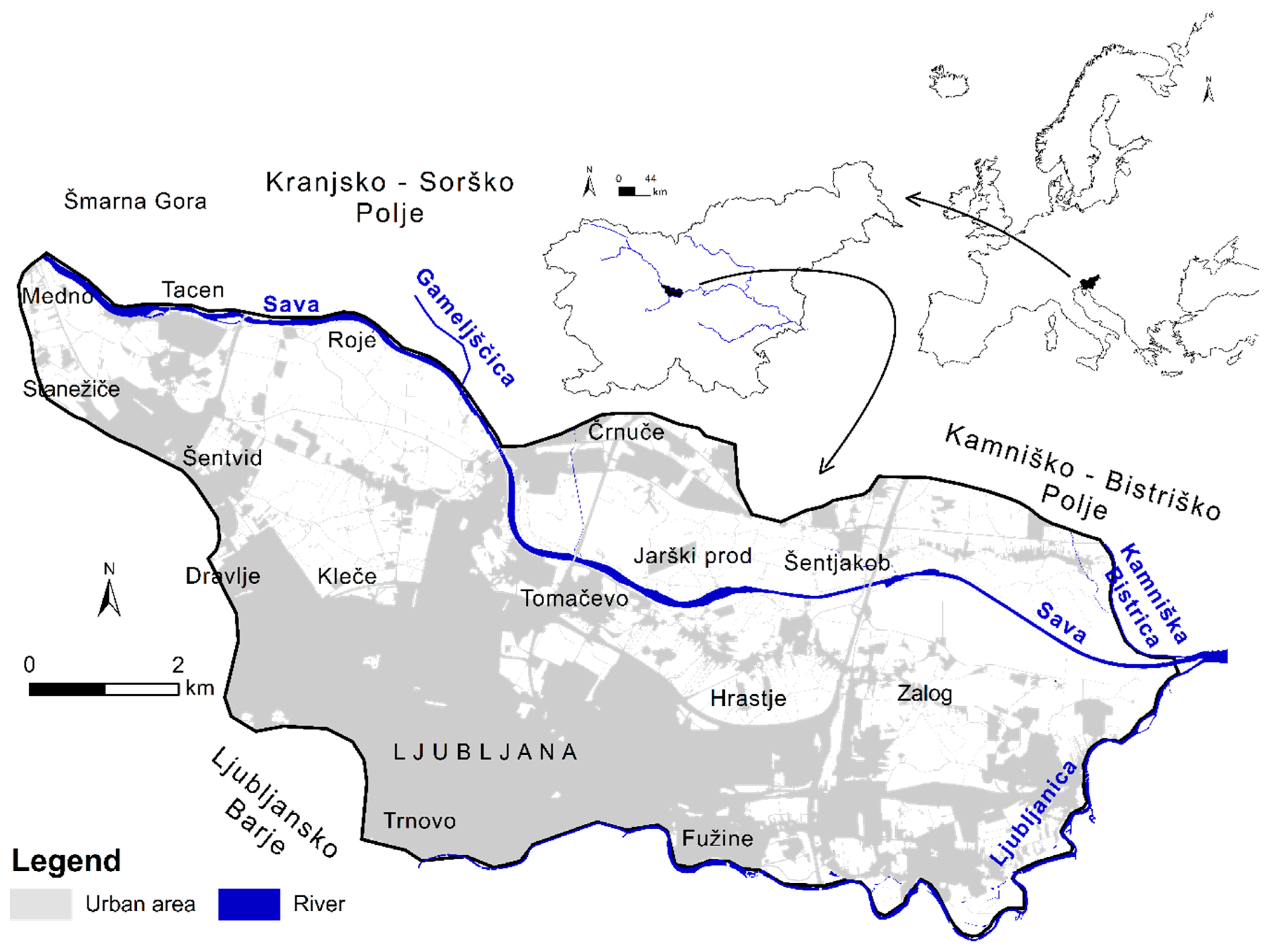
2.1. The Ljubljansko Polje
2.2. Database
2.3. Data Quality Control
- Before applying multivariate statistical analysis, the database was reduced in size using linear correlation. The 47 piezometers, where the hydraulic heads were measured (2003–2015), were divided into five groups. Each group included piezometers with high correlation coefficients, R2 ≥ 0.95, due to similar patterns of hydraulic heads. These groups also have specific locations in the Ljubljansko polje (Figure 2). Only one piezometer from each group, with minimal data gaps in their sets, were selected as being representative and used for data analyses.Due to the high correlation (R2 > 0.99) between the Sava River discharges observed at the three gauging stations, located at short distances from one another (~6.5 km), only discharges measured in Šentjakob were analyzed. The analysis also includes the Ljubljanica River discharge. Precipitation, which was recorded at the meteorological station in Ljubljana (Bežigrad, Figure 2), does not correlate with the discharges of the Sava and the Ljubljanica Rivers due to the remoteness of their springs where different climate conditions prevail.
- Those piezometers, in which significantly different elevations of hydraulic heads from the majority of the piezometers were recorded, were excluded from the database (Figure S2).
2.4. System Responsiveness
2.5. Modeling Tools
2.5.1. WaSiM
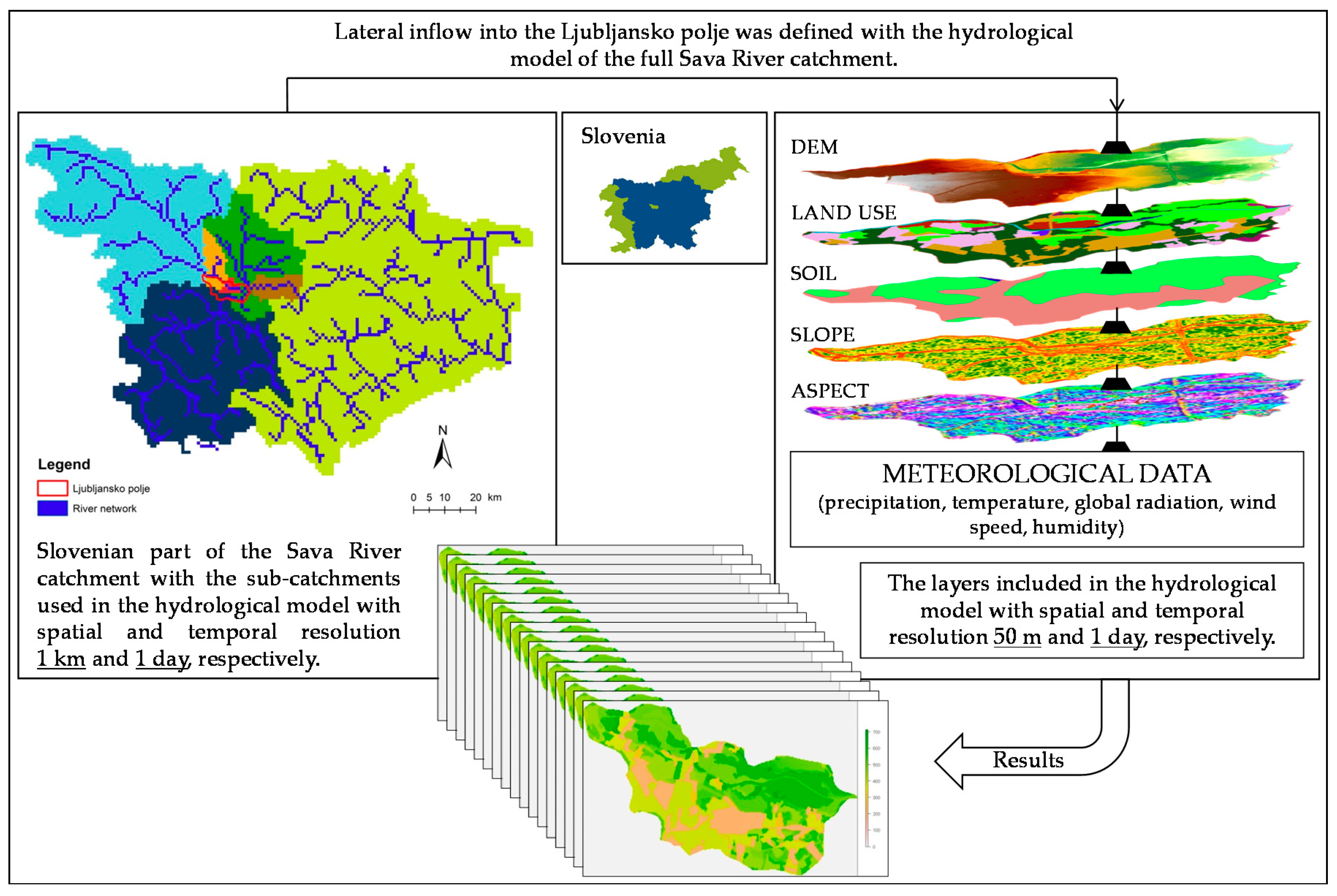
2.5.1.1. Setting Up the WaSiM Model
2.5.1.2. Calibration and Validation of the WaSiM Model
2.5.2. MIKE 11
Setting Up of the MIKE 11 Model
2.5.3. FEFLOW
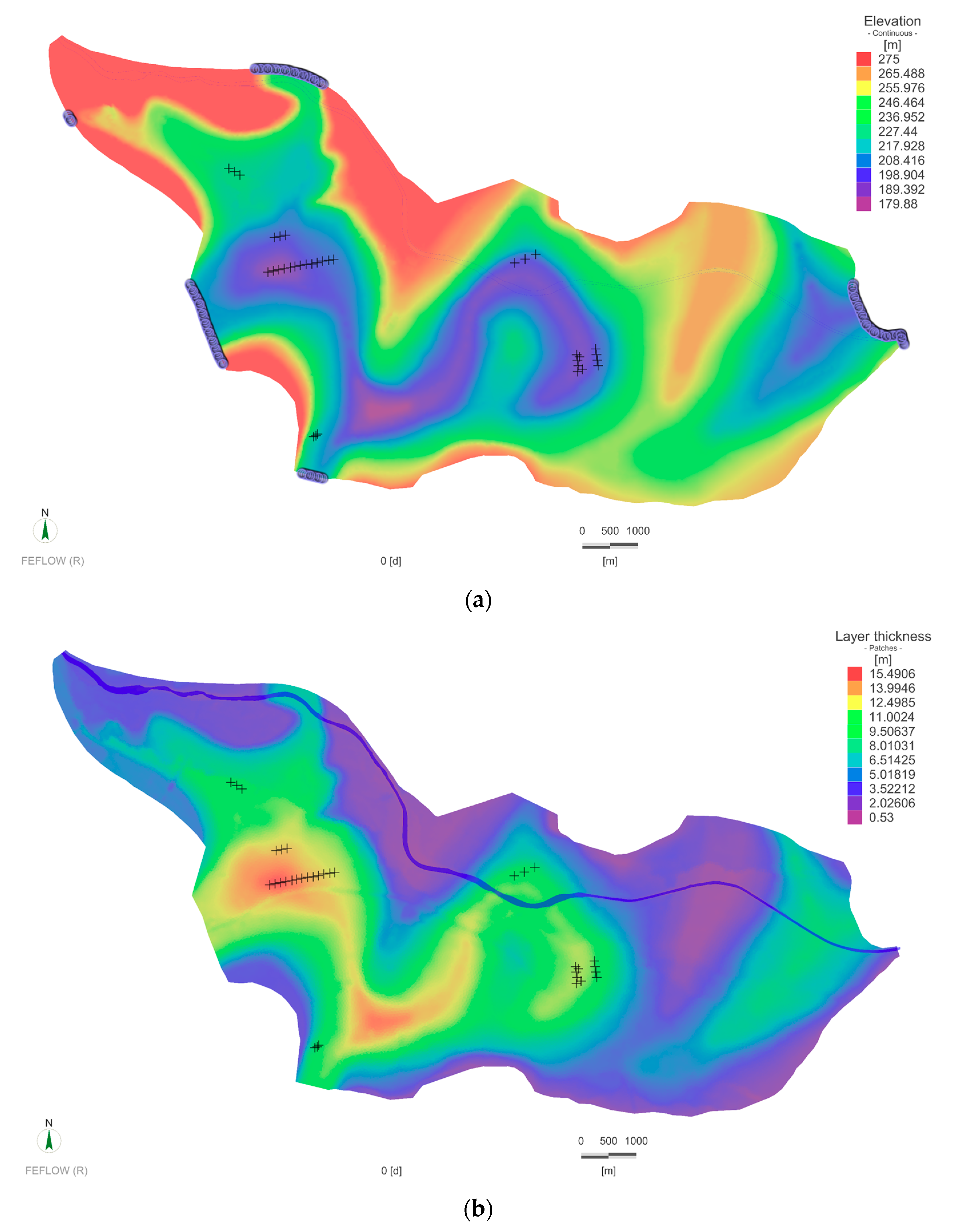
2.5.3.1. Development of the Physical Framework
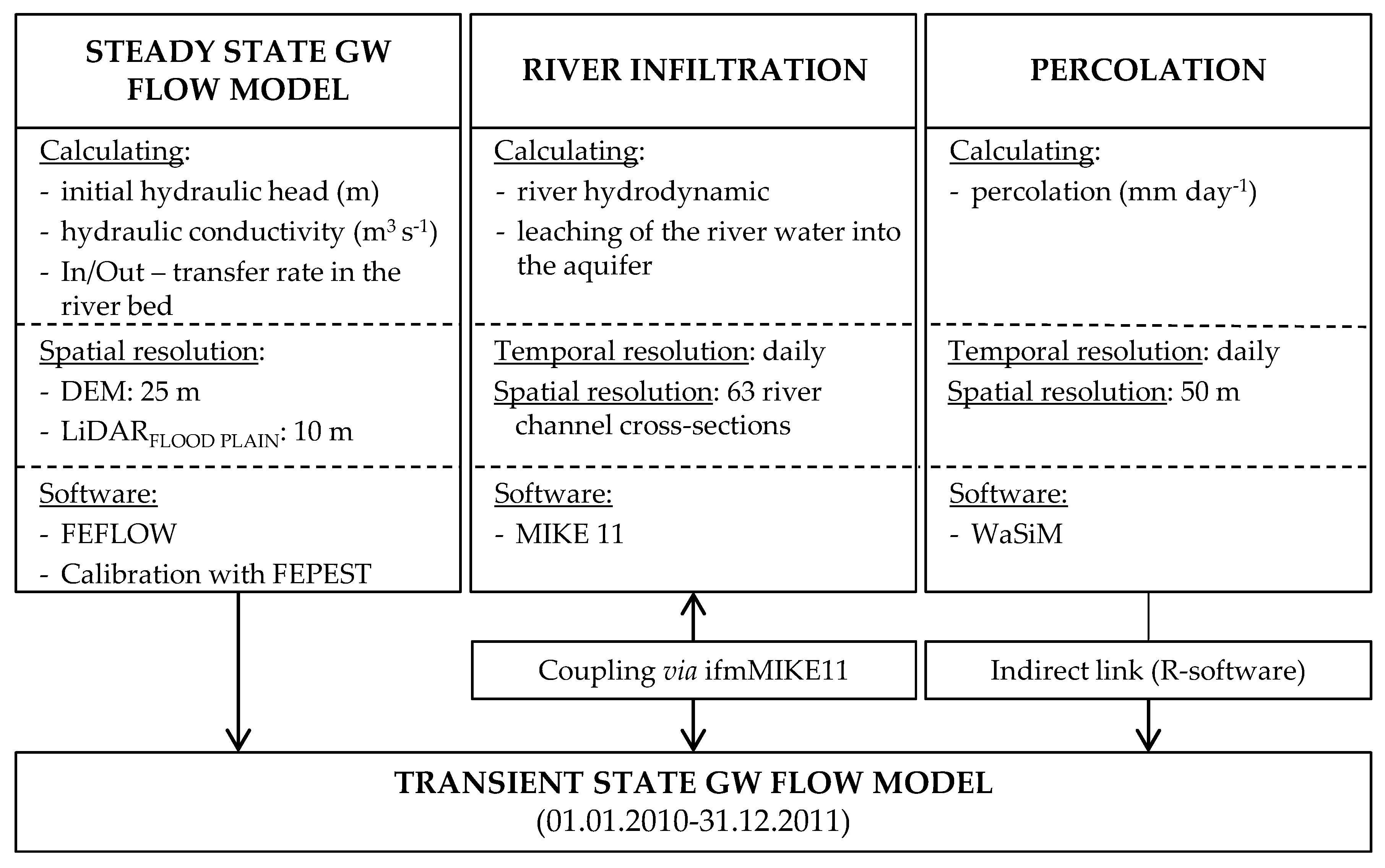
2.5.3.2. Setting Up the Steady-State and Transient State Groundwater Flow Models
2.5.3.3. Calibration and Validation of the FEFLOW Models
3. Results
3.1. WaSiM Model
3.2. Groundwater Flow Model (FEFLOW-WaSiM-ifmMIKE11)
3.2.1. The Steady-State Groundwater Flow Model
3.2.2. The Transient State Groundwater Flow Model
4. Discussion
4.1. An Interpretation of Observed Data and an Estimation of the System Responsiveness
4.2. The WaSiM Model
4.3. The Steady-State Groundwater Flow Model
4.4. The Transient State Groundwater Flow Model
5. Conclusions
Supplementary Materials
Author Contributions
Funding
Acknowledgments
Conflicts of Interest
References
- Fleckenstein, J.H.; Krause, S.; Hannah, D.M.; Boano, F. Groundwater-surface water interactions: New methods and models to improve understanding of processes and dynamics. Adv. Water Resour. 2010, 33, 1291–1295. [Google Scholar] [CrossRef]
- National Academic of Science, Engineering, and Medicine. From Maps to Models: Augmenting the Nation’s Geospatial Intelligence Capabilities; The National Academies Press: Washington, DC, USA, 2016; p. 121. [Google Scholar]
- Gyopari, M.C.; McAlister, D. Wairarapa Valley Groundwater Resource Investigation: Upper Valley Catchment Hydrogeology and Modelling; Technical Publication GW/EMI-T-10/74; Greater Wellington: Wellington, New Zealand, 2010; p. 108. [Google Scholar]
- Monninkhoff, B.L.; Li, Z. Coupling FEFLOW and MIKE11 to optimise the flooding system of the Lower Havel polders in Germany. Int. J. Water 2009, 5, 163–180. [Google Scholar] [CrossRef]
- Natkhin, M. Modellgestützte Analyse der Einflüsse von Veränderungen der Waldwirtschaft und des Klimas auf den Wasserhaushalt Grundwasserabhängiger Landschaftselemente. Master’s Thesis, University of Potsdam, Potsdam, Germany, 2010. (In German). [Google Scholar]
- Gunduz, O.; Aral, M. Surface Water—Groundwater Interactions: Integrated Modeling of a Coupled System. In Handbook of Applied Hydrology; Singh, V.P., Ed.; McGraw-Hill Inc.: New York, NY, USA, 2016; pp. 54.1–54.14. [Google Scholar]
- Barthel, R.; Banzhaf, S. Groundwater and Surface Water Interaction at the Regional-Scale—A Review with Focus on Regional Integrated Models. Water Resour. Manag. 2016, 30, 1–32. [Google Scholar] [CrossRef]
- Krause, S.; Bronstert, A. The impact of groundwater–surface water interactions on the water balance of a mesoscale lowland river catchment in northeastern Germany. Hydrol. Process. 2007, 21, 169–184. [Google Scholar] [CrossRef]
- Wei, X.; Bailey, R.T.; Records, R.M.; Wible, T.C.; Arabi, M. Comprehensive simulation of nitrate transport in coupled surface-subsurface hydrologic systems using the linked SWAT-MODFLOW-RT3D model. Environ. Model. Softw. 2018. [Google Scholar] [CrossRef]
- Trichakis, I.; Burek, P.; De Roo, A.; Pistocchi, A. Towards a Pan-European Integrated Groundwater and Surface Water Model: Development and Applications. Environ. Process. 2017, 17, 81–93. [Google Scholar] [CrossRef]
- Rodriguez, L.B.; Cello, P.A.; Vionnet, C.A.; Goodrich, D. Fully conservative coupling of HEC-RAS with MODFLOW to simulate stream–aquifer interactions in a drainage basin. J. Hydrol. 2008, 353, 129–142. [Google Scholar] [CrossRef]
- Inter 3 Institute for Resource Management GmbH. Integrated Water Resources Management Zayandeh Rud: German-Iranian Research and Development Cooperation for a Better Future. Available online: https://www.inter3.de/fileadmin/user_upload/Downloads/Flyer_usw/download_IWRM-en.pdf (accessed on 16 August 2017).
- Guay, C.; Nastev, M.; Paniconi, C.; Sulis, M. Comparison of Two Modeling Approaches for Groundwater–Surface Water Interactions. Hydrol. Process. 2013, 27, 2258–2270. [Google Scholar] [CrossRef]
- Cheo, A.E.; Voigt, H.-J.; Wendland, F. Modeling groundwater recharge through rainfall in the Far-North region of Cameroon. Groundw. Sustain. Dev. 2017, 5, 118–130. [Google Scholar] [CrossRef]
- Andjelov, M.; Mikulič, Z.; Tetzlaff, B.; Wendland, F.; Uhan, J. Groundwater Recharge in Slovenia—Results of a Bilateral German-Slovenian Research Project; Forschungszentrum Jülich GmbH Zentralbibliothek: Jülich, Germany, 2016; Volume 339. [Google Scholar]
- Epting, J.; Huggenberger, P.; Radny, D.; Hammes, F.; Hollender, J.; Page, R.M.; Weber, S.; Bänninger, D.; Auckenthaler, A. Spatiotemporal scales of river-groundwater interaction—The role of local interaction processes and regional groundwater regimes. Sci. Total Environ. 2018, 618, 1224–1243. [Google Scholar] [CrossRef]
- Feinstein, D. Since “Groundwater and Surface Water–A Single Resource”: Some U.S. Geological Survey advances in modeling groundwater/surface-water interactions. Acque Sotter. Ital. J. Groundw. 2012, 1, 9–24. [Google Scholar] [CrossRef]
- Brunner, P.; Simmons, C.T.; Cook, P.G. Spatial and Temporal Aspects of the Transition from Connection to Disconnection between Rivers, Lakes and Groundwater. J. Hydrol. 2009, 376, 159–169. [Google Scholar] [CrossRef]
- Fleckenstein, J.H.; Niswonger, R.G.; Fogg, G.E. River-Aquifer Interactions, Geologic Heterogeneity, and Low-Flow Management. Ground Water 2006, 44, 837–852. [Google Scholar] [CrossRef] [PubMed]
- Vrzel, J.; Solomon, D.K.; Blažeka, Ž.; Ogrinc, N. The study of the interactions between groundwater and Sava River water in the Ljubljansko polje aquifer system (Slovenia). J. Hydrol. 2018, 556, 384–396. [Google Scholar] [CrossRef]
- Urbanc, J.; Jamnik, B. Isotope investigations of groundwater from Ljubljansko polje (Slovenia). Geologia 1998, 41, 355–364. [Google Scholar] [CrossRef]
- Šram, D.; Brenčič, M.; Lapanje, A.; Janža, M. Perched Aquifers Spatial Model: A Case Study for Ljubljansko Polje (Central Slovenia). Geologija 2012, 55, 107–116. [Google Scholar] [CrossRef]
- Cerar, S.; Urbanc, J. Carbonate Chemistry and Isotope Characteristics of Groundwater of Ljubljansko Polje and Ljubljansko Barje Aquifers in Slovenia. Sci. World J. 2013, 2013, 1–11. [Google Scholar] [CrossRef] [PubMed]
- Auersperger, P.; Čenčur Curk, B.; Jamnik, B.; Janža, M.; Kus, J.; Prestor, J.; Urbanc, J. Dinamika Podzemne Vode. In Podtalnica Ljubljanskega Polja; Rejec Brancelj, I., Smrekar, A., Kladnik, D., Eds.; Založba ZRC: Ljubljana, Slovenia, 2005; pp. 39–61. (In Slovene) [Google Scholar]
- All Work Package Leaders & the whole CC-WaterS Project Consortium. Climate Change and Impacts on Water Supply “CC-WaterS”. Available online: http://www.ccwaters.eu/downloads/CC-WaterS_Project_Monography_final.pdf (accessed on 16 August 2017).
- Janža, M.; Meglič, P.; Šram, D. Numerical Hydrological Modelling; Final Report P-II-30d/b-5/1-d; Geological Survey of Slovenia: Ljubljana, Slovenia, 2011; p. 66. [Google Scholar]
- Slovenian Environment Agency. Dostop Do Podatkov o Vodah v Sloveniji (in Slovene). Available online: http://vode.arso.gov.si (accessed on 12 August 2017).
- Slovenian Environment Agency, METEO. Available online: http://meteo.arso.gov.si (accessed on 12 August 2017). (In Slovene)
- Schulla, J. Model Description WaSiM (Water Balance Simulation Model); Technical Report; Hydrology Software Consulting J. Schulla: Zurich, Switzerland, 2015; p. 332. [Google Scholar]
- Strojan, I.; Kobold, M.; Polajnar, J.; Šupek, M.; Pogačnik, N.; Jeromelj, M.; Petan, S.; Lalič, B.; Trček, R. Poplave v Dneh od 17. do 21. Septembra 2010. Miš. Vod. Dan: Zbor. Ref. 2010, 21, 1–11. (In Slovene) [Google Scholar]
- Cegnar, T. Climate in Slovenia in 2011. Ujma 2012, 26, 20–32. (In Slovene) [Google Scholar]
- Wessolek, G.; Kaupenjohann, M.; Renger, M. Bodenphysikalische Kennwerte Und Berechnungsverfahren Für Die Praxis; Facklam, M., Ed.; Technische Universitaet Berlin: Berlin, Germany, 2009. (In Germany) [Google Scholar]
- Renger, M.; Bohne, K.; Facklam, M.; Harrach, T.; Riek, W.; Schäfer, W.; Wessolek, G.; Zacharias, S. Ergebnisse und Vorschläge der DBG-Arbeitsgruppe ”Kennwerte des Bodengefüges“ zur Schätzung Bodenphysikalischer Kennwerte (in German); Deutsche Bodenkundliche Gesellschaft: Goettingen, Germany, 2008; p. 51. [Google Scholar]
- Soil Moisture Classification. Available online: http://www.terragis.bees.unsw.edu.au/terraGIS_soil/sp_water-soil_moisture_classification.html (accessed on 3 May 2017).
- CORINE Land Cover Database of the Year 2006. Available online: https://www.eea.europa.eu/data-and-maps/data/clc-2006-raster-4#tab-european-data (accessed on 5 December 2016).
- Pignotti, G.; Rathjens, H.; Cibin, R.; Chaubey, I.; Crawford, M. Comparative Analysis of HRU and Grid-Based SWAT Models. Water 2017, 9, 272. [Google Scholar] [CrossRef]
- Moving Windows. Available online: http://www.gitta.info/ContiSpatVar/en/html/SpatDependen_learningObject2.xhtml (accessed on 27 December 2017).
- Refsgaard, J.C.; Storm, B. Construction, Calibration and Validation of Hydrological Models. In Distributed Hydrological Modelling; Abbott, M.B., Refsgaard, J.C., Eds.; Springer: Dordrecht, The Netherlands, 1990; Volume 22, pp. 41–54. [Google Scholar]
- Povprečne Mesečne Vrednosti Evapotranspiracije v Obdobju 1971–2000 (in Slovene). Available online: http://meteo.arso.gov.si/met/sl/agromet/period/etp/ (accessed on 30 September 2018).
- Pintar, M.; Korpar, P.; Zupanc, V. Meritve na Lizimetrski Postaji v Klečah: Poročilo za Leto 2012; University of Ljubljana: Ljubljana, Slovenia, 2013. (In Slovene) [Google Scholar]
- Monninkhoff, B. IfmMIKE11 2.1: User Manual; DHI-WASY GmbH: Berlin, Germany, 2014; p. 132. [Google Scholar]
- Diem, S.; Renard, P.; Schirmer, M. Assessing the effect of different river water level interpolation schemes on modeled groundwater residence times. J. Hydrol. 2014, 510, 393–402. [Google Scholar] [CrossRef] [Green Version]
- Cardenas, M.B. Stream-aquifer interactions and hyporheic exchange in gaining and losing sinuous streams. Water Resour. Res. 2009, 45, 1–13. [Google Scholar] [CrossRef]
- Cardenas, M.B.; Wilson, J.L.; Zlotnik, V.A. Impact of heterogeneity, bed forms, and stream curvature on subchannel hyporheic exchange. Water Resour. Res. 2004, 40, 1–13. [Google Scholar] [CrossRef]
- Woessner, W.W. Stream and Fluvial Plain Ground Water Interactions: Rescaling Hydrogeologic Thought. Ground Water 2000, 38, 423–429. [Google Scholar] [CrossRef]
- Jarrett, R.D. Determination of Roughness Coefficients for Streams in Colorado; Water-Resources Investigations 85–4004; U.S. Geological Survey: Lakewood, CO, USA, 1985; p. 54.
- Steinman, F.; Banovec, P.; Gosar, L.; Rak, G.; Pogačnik, N.; Koželj, D.; Petkovšek, G.; Pipan, G.; Artač, M.; Šterk, M.; et al. Interactive Visualization of Floodplain Areas for Disaster Response Support; Final Report; Administration of the RS for Civil Protection and Disaster Relief, Ministry of Defence, Republic of Slovenia: Ljubljana, Slovenia, 2008; p. 258. (In Slovene)
- Diersch, H.J.G. FEFLOW Finite Element Modeling of Flow, Mass and Heat Transport in Porous and Fractured Media; Springer: Berlin/Heidelberg, Germany, 2014. [Google Scholar]
- Monninkhoff, L.; Hartnack, J. Improvements in the Coupling Interface between FEFLOW and MIKE11. 2009, pp. 1–12. Available online: https://pdfs.semanticscholar.org/aac7/a7ee00b41562869481555d7db99f2587c668.pdf?_ga=2.130108879.1923207088.1566342415-1995382604.1562081892 (accessed on 16 August 2017).
- Kaiser, B.O.; Scheck-Wenderoth, M.; Cacace, M.; Lewerenz, B. Characterization of main heat transport processes in the Northeast German Basin: Constraints from 3-D numerical models. Geochem. Geophys. Geosystems 2011, 12, 1–17. [Google Scholar] [CrossRef]
- Interpolation Methods. Available online: http://www.gisresources.com/types-interpolation-methods_3/ (accessed on 6 July 2017).
- FePEST in FEFLOW 7.0, User Guide. Available online: https://www.mikepoweredbydhi.com/download/product-documentation (accessed on 16 August 2017).
- Toews, M.; Daughney, C.J.; Cornaton, F.J.; Morgenstern, U.; Evison, R.D.; Jackson, B.M.; Petrus, K.; Mzila, D. Numerical simulation of transient groundwater age distributions assisting land and water management in the Middle Wairarapa Valley, New Zealand. Water Resour. Res. 2016, 52, 9430–9451. [Google Scholar] [CrossRef]
- Gusyev, M.A.; Toews, M.; Morgenstern, U.; Stewart, M.; White, P.; Daughney, C.; Hadfield, J. Calibration of a transient transport model to tritium data in streams and simulation of groundwater ages in the western Lake Taupo catchment, New Zealand. Hydrol. Earth Syst. Sci. 2013, 17, 1217–1227. [Google Scholar] [CrossRef] [Green Version]
- Sanford, W. Calibration of Models Using Groundwater Age. Hydrogeol. J. 2011, 19, 13–16. [Google Scholar] [CrossRef]
- Sheets, R.A.; Bair, E.S.; Rowe, G.L. Use of 3 H/3 He Ages to evaluate and improve groundwater flow models in a complex buried-valley aquifer. Water Resour. Res. 1998, 34, 1077–1089. [Google Scholar] [CrossRef]
- Doherty, J. Ground Water Model Calibration Using Pilot Points and Regularization. Ground Water 2003, 41, 170–177. [Google Scholar] [CrossRef]
- Andjelov, M.; Bat, M.; Frantar, P.; Mikulič, Z.; Savić, V.; Uhan, J. Pregled Elementov Vodne Bilance. In Podtalnica Ljubljanskega Polja; Rejec Brancelj, I., Smrekar, A., Kladnik, D., Eds.; Založba ZRC: Ljubljana, Slovenia, 2005; pp. 27–38. (In Slovene) [Google Scholar]
- Posavec, K.; Vukojević, P.; Ratkaj, M.; Bedeniković, T. Cross-Correlation Modelling of Surface Water—Groundwater Interaction Using the Excel Spreadsheet Application. Rud. Geološko Naft. Zb. 2017, 32, 25–32. [Google Scholar] [CrossRef]
- Post, V.E.A.; Von Asmuth, J.R.; Asmuth, J.R. Review: Hydraulic head measurements—New technologies, classic pitfalls. Hydrogeol. J. 2013, 21, 737–750. [Google Scholar] [CrossRef]
- Asmael, N.; Dupuy, A.; Huneau, F.; Hamid, S.; Le Coustumer, P. Groundwater Modeling as an Alternative Approach to Limited Data in the Northeastern Part of Mt. Hermon (Syria), to Develop a Preliminary Water Budget. Water 2015, 7, 3978–3996. [Google Scholar] [CrossRef] [Green Version]
- Bouaziz, L.; Weerts, A.; Schellekens, J.; Sprokkereef, E.; Stam, J.; Savenije, H.; Hrachowitz, M. Redressing the balance: Quantifying net intercatchment groundwater flows. Hydrol. Earth Syst. Sci. 2018, 22, 6415–6434. [Google Scholar] [CrossRef]
- Ackerman, D.J.; Rousseau, J.P.; Rattray, G.W.; Fisher, J.C. Steady-state and transient models of groundwater flow and advective transport, Eastern Snake River Plain aquifer, Idaho National Laboratory and vicinity, Idaho. Sci. Investig. Rep. 2010. [Google Scholar] [CrossRef]
- Zhou, Y.; Herath, H. Evaluation of alternative conceptual models for groundwater modelling. Geosci. Front. 2017, 8, 437–443. [Google Scholar] [CrossRef] [Green Version]
- Guastaldi, E.; Carloni, A.; Pappalardo, G.; Nevini, J. Geostatistical Methods for Lithological Aquifer Characterization and Groundwater Flow Modeling of the Catania Plain Quaternary Aquifer (Italy). J. Water Resour. Prot. 2014, 6, 272–296. [Google Scholar] [CrossRef] [Green Version]
- Anderson, M.P.; Woessner, W.W.; Hunt, R.J. Applied Groundwater Modeling Simulation of Flow and Advective Transporte, 2nd ed.; Elsevier Inc.: London, UK, 2015. [Google Scholar]
- Vrzel, J.; Ogrinc, N.; Vižintin, G. Data Preparation for Groundwater Modelling—Ljubljansko Polje Aquifer System. RMZ M&G 2015, 62, 167–173. [Google Scholar]




| Code | Soil Texture Type | Description | Percentage (%) |
|---|---|---|---|
| 1 | Artificial area | Data cannot be defined | 39.60 |
| 2 | Coarse | Sand/Loamy/Sand/Sandy loam | 30.05 |
| 3 | Coarse–Medium | Sand/Loamy sand/Sandy loam/Sandy clay loam/Clay loam/Loam/Silt loam | 27.51 |
| 4 | Medium | Sandy clay loam/Clay loam/Loam/Silt loam | 2.77 |
| 5 | Medium–Fine–Fine | Sandy clay loam/Clay loam/Loam/Silt loam/Silt/Silty clay loam/Silty clay/Sandy clay/Clay | 0.06 |
| 6 | Very fine | Silt/Silty clay loam/Silty clay/Sandy clay/Clay | 0.01 |
| Code | Land Use Type | Percentage (%) |
|---|---|---|
| 1 | Heterogeneous agricultural areas | 15.72 |
| 2 | Arable land | 22.70 |
| 3 | Meadow | 0.31 |
| 4 | Mixed forest | 4.74 |
| 5 | Urban | 30.44 |
| 6 | Transitional woodland | 0.92 |
| 7 | Industrial area | 19.30 |
| 8 | Pastures | 2.92 |
| 9 | Water | 2.97 |
| Use | Module | Parameter | Period | Description |
|---|---|---|---|---|
| C | Evapotranspiration | Real ET (mm (dt)−1) | 1 January 2010–31 December 2014 | Calculated real ET was compared with the referential ET in Bežigrad (46°3′56″ N, 14°30′45″ E, altitude 299 m), which were calculated by ARSO (Source: http://meteo.arso.gov.si). |
| V | 1 January 2008–31 December 2009 | |||
| C | Unsaturated Zone | Soil moisture within the root zone (%) | 1 January 2012–31 December 2012 | Calculated soil moisture was compared with the observed soil moisture data in Kleče (46°5′11″ N, 14°29′56″ E, altitude 308 m) during the period January 2012–August 2012 [40]. |
| C | Unsaturated Zone | Hydraulic head below the surface (m) | 1 January 2010–31 December 2014 | Trends of calculated percolation were compared with trends of the observed hydraulic head. |
| V | 1 January 2009–31 December 2009 |
| Location | Hydraulic Head BC |  |
| Trnovo | P-102 + 0.48 m | |
| Dravlje | P-038 + (−2.00–2.20 m) | |
| Roje | P-097 + (2.00–2.20 m) | |
| Stanežiče | P−098 + 0.66 m | |
| Outflow | P-017 + (−3.69–0.51 m) |
| Step 1 (Steady-State GW Flow Model) | Step 2 (Steady-State GW Flow Model + MRT) | Step 5 2 November 2010 (306 day) | Step 5 1 July 2010 (182 day) | |
|---|---|---|---|---|
| Ē | 0.125 | 0.260 | 0.445 | 0.943 |
| RMS | 0.169 | 0.343 | 0.563 | 1.062 |
| σ | 0.173 | 0.351 | 0.575 | 1.085 |
© 2019 by the authors. Licensee MDPI, Basel, Switzerland. This article is an open access article distributed under the terms and conditions of the Creative Commons Attribution (CC BY) license (http://creativecommons.org/licenses/by/4.0/).
Share and Cite
Vrzel, J.; Ludwig, R.; Vižintin, G.; Ogrinc, N. An Integrated Approach for Studying the Hydrology of the Ljubljansko Polje Aquifer in Slovenia and Its Simulation. Water 2019, 11, 1753. https://doi.org/10.3390/w11091753
Vrzel J, Ludwig R, Vižintin G, Ogrinc N. An Integrated Approach for Studying the Hydrology of the Ljubljansko Polje Aquifer in Slovenia and Its Simulation. Water. 2019; 11(9):1753. https://doi.org/10.3390/w11091753
Chicago/Turabian StyleVrzel, Janja, Ralf Ludwig, Goran Vižintin, and Nives Ogrinc. 2019. "An Integrated Approach for Studying the Hydrology of the Ljubljansko Polje Aquifer in Slovenia and Its Simulation" Water 11, no. 9: 1753. https://doi.org/10.3390/w11091753
APA StyleVrzel, J., Ludwig, R., Vižintin, G., & Ogrinc, N. (2019). An Integrated Approach for Studying the Hydrology of the Ljubljansko Polje Aquifer in Slovenia and Its Simulation. Water, 11(9), 1753. https://doi.org/10.3390/w11091753


