Water Resource Assessment of a Complex Volcanic System Under Semi-Arid Climate Using Numerical Modeling: The Borena Basin in Southern Ethiopia
Abstract
:1. Introduction
2. Materials and Methods
2.1. Study Site, the Borena Basin
2.1.1. Location of the Borena Basin
2.1.2. Geology and Hydrogeological Setting
- -
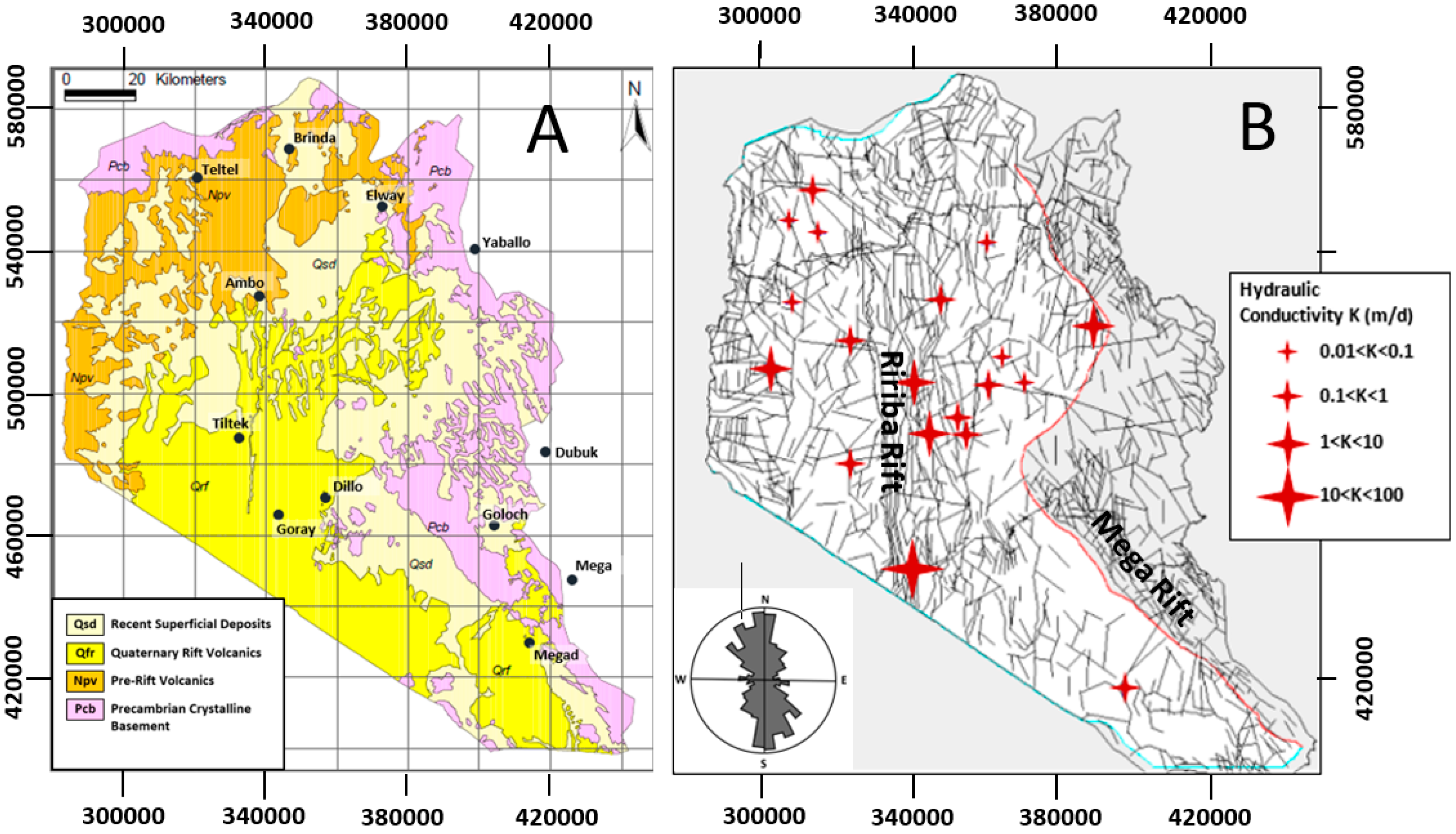
- Tertiary volcanics: Pre-rift/Syn-rift volcanics including the Teltele basaltic sequence. The prominent mountainous ridges in the west and northwestern parts of the area, are made up of Teltele flood basalts. These volcanic successions have significant thickness exceeding three hundreds of meters.
- -
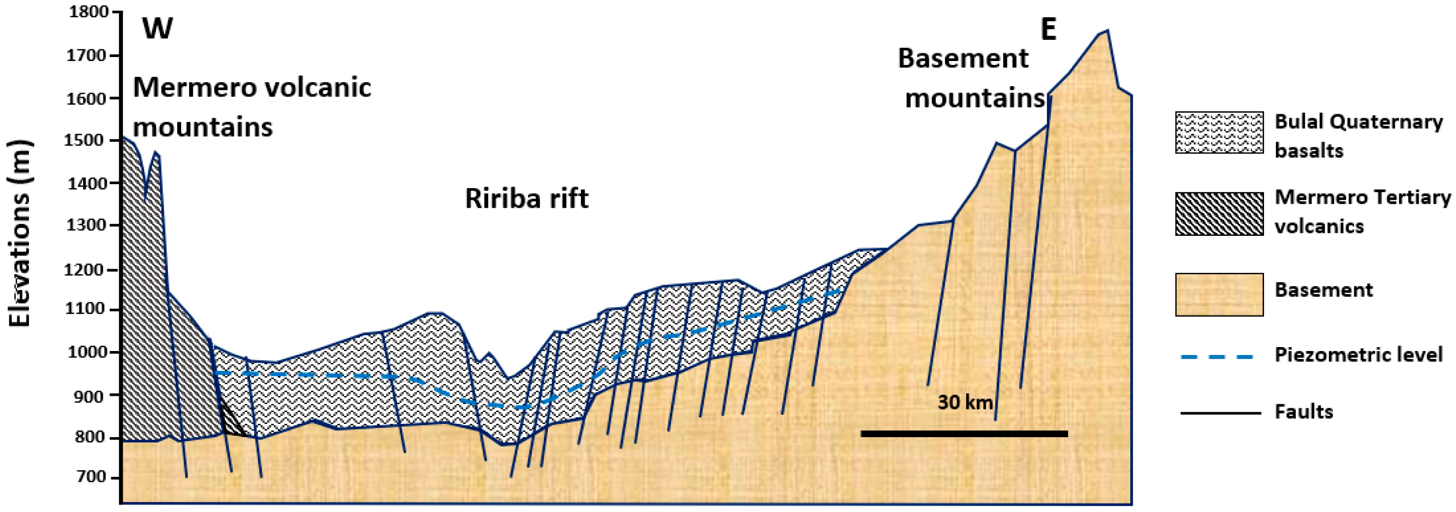
- Quaternary volcanics: Recent/Post Rift volcanics including the Bulal basalts. The Bulal basalts are the dominant horizontally layered sheets of basalt flows mapped in the area. This formation overlies the basement and its average thickness is about 200 m. The areas of Bulal basalts occurrence include vast terrains stretching from the southeastern periphery, to areas in the western-northwestern, north-eastern and central parts of the study area.
- -
- In all localities for which environmental isotope data were available, the dating results are returned as modern age, i.e., post 1950s. Some waters with low tritium content are on the order of a few decades. Therefore, the aquifer system of the region is associated with modern day recharge.
- -
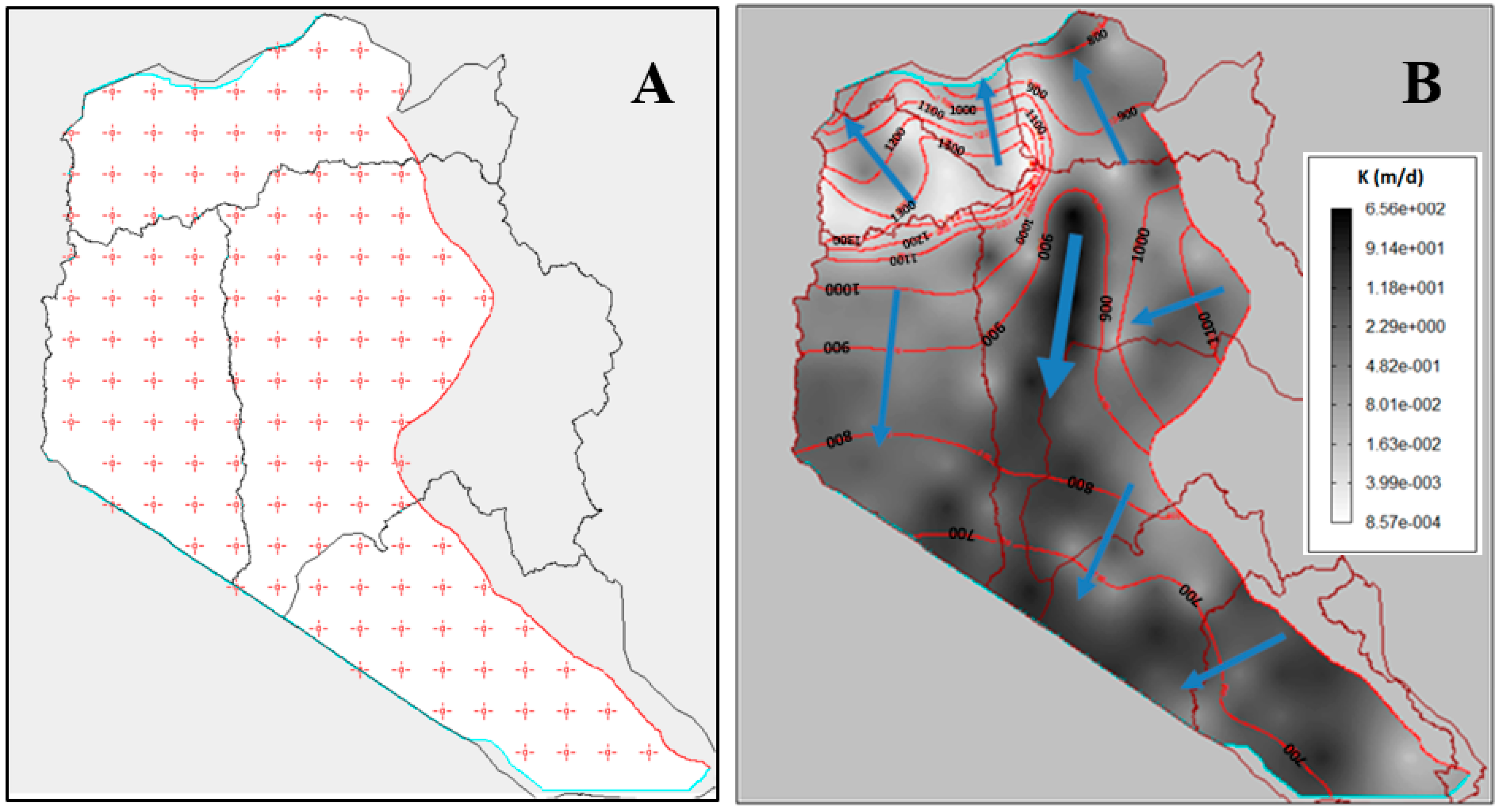
- The environmental isotope analysis, associated with hydrogeochemical analyses, clearly indicates regional groundwater flow from the eastern crystalline highlands to the central part (middle Gelchet plains) and to southeast following the lowlands.
- -
- A flow from Mega and Megado escarpments to Megado/Biloko lowlands is also identified.
- -
- The inflow from the eastern boundary and the outflow at the Ethio-Kenyan boundary are clearly shown. Please note that this inflow to the aquifer from the eastern highlands is also supported by the isotopes and hydrochemical analyses.
- -
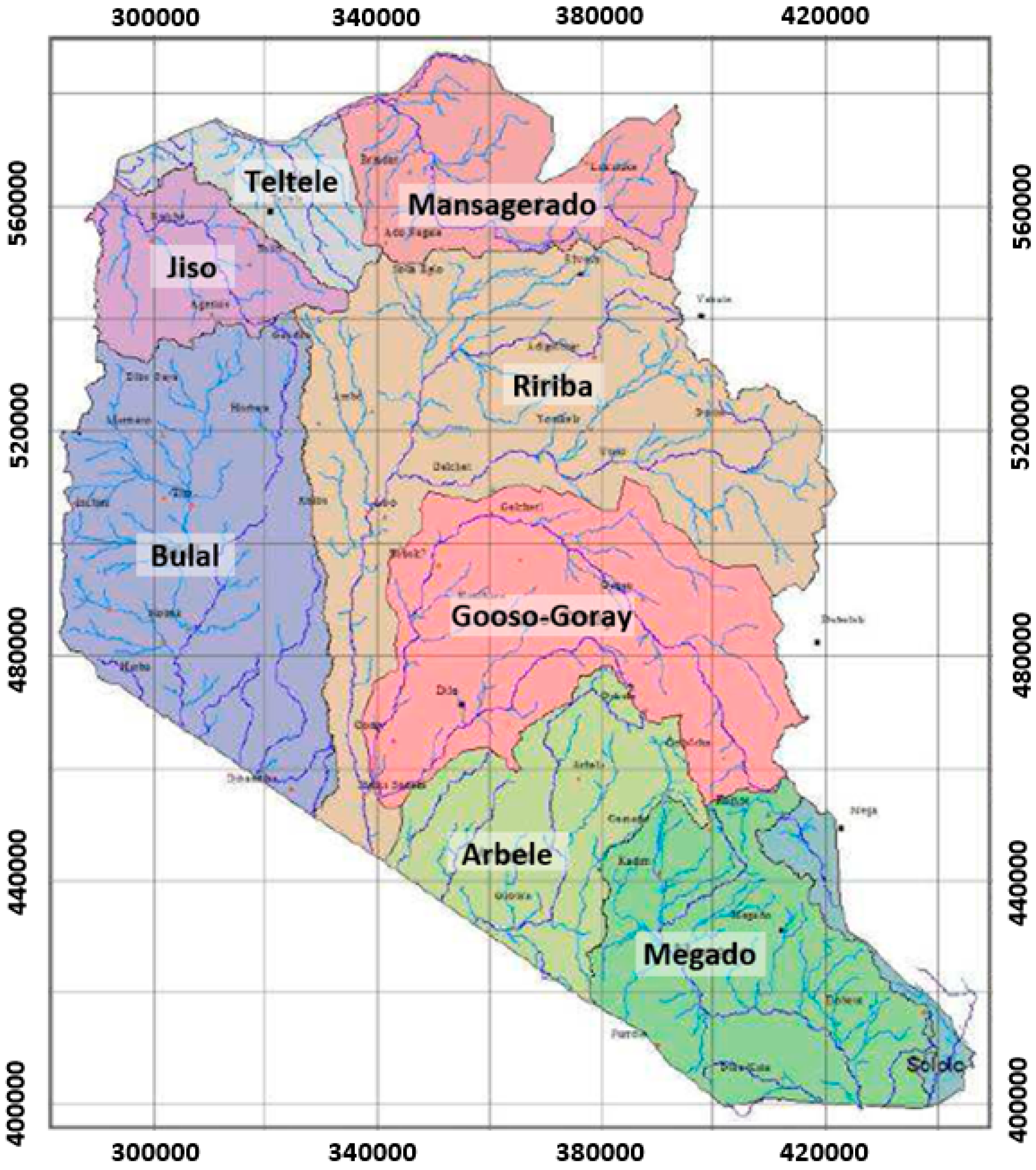
- A groundwater divide is illustrated in the northern part, and coincides with the surface water divide between Mansagerado and Ririba sub-basins.
- -
- The role of the Ririba rift is well highlighted. Groundwater flow is converging from the eastern, western and northern highlands to the Rirriba rift zone.
- -
- This map also clarifies the relations between the northern Teltele area and the main flow area southward. Groundwater is located at much higher altitudes (compared to Bulal/Ririba basins), and flows towards East to the Mansagerado sub-basin, South to the Ririba basin and to the North and West. High gradients between the Teltele basins and the adjacents basins (Ririba and Mansagerado) are depicted.
- -
- Consequently, the piezometric data lead to the conclusion that groundwater is unconfined in the study area at the basin’s scale, flows through the Ririba rift valley and leaves out the study area mainly towards Kenya.
2.1.3. Drainage Networks
2.2. Conceptual Model
2.2.1. Aquifer Geometry and Boundary Conditions
- -
- The northern boundary coincides with the northern limits of the Teltele sub-basins. A general head boundary (GHB) is assigned to this limit of the Borena basin.
- -
- The north-western boundary is a no-flow boundary and coincides with the Mermero mountain range.
- -
- The eastern limit, represented by the basalts and basement contact, is designated as an inflow BC.
- -
- The south-western limit of the flow domain, which represents the Ethio-Kenyan border, is designated as mixed BC.
2.2.2. Model Design
2.3. Calibration Method
3. Results and Discussion
3.1. Calibration of the Model
3.2. Simulated Piezometry
- -
- An important groundwater flow zone appears along the Ririba rift valley towards the Kenyan border to the south; this flow is probably associated with existing N-S structures in this area;
- -
- The basaltic system is supplied on the eastern boundary, in contact with the basement rocks;
- -
- The surface water divide line between the Teltele sub-basins and the main basins of Bulal/Ririba also marks a divergence of the underground flow over the entire study area: south of this line, groundwater flows to the Kenyan border, north of this line, it flow towards the Segen river;
- -
- The high hydraulic head values in the Teltele basin are well simulated;
- -
- The very high flow gradients on the boundaries of the Teltele basin are simulated correctly;
- -
- The Kenyan border is the main outlet for the groundwater flow to the south.
3.3. Water Balance Simulated by the Model
3.4. Sensitivity Analysis
3.5. Simulation of Groundwater Resource Exploitation
3.5.1. Simulation Using the Global Model
3.5.2. Wellfield Simulations and Optimization
4. Conclusions
Supplementary Materials
Author Contributions
Funding
Acknowledgments
Conflicts of Interest
References
- Word Population Review. 2019. Available online: http://worldpopulationreview.com/countries/ethiopia-population/ (accessed on 1 September 2019).
- World Bank. 2019. Available online: https://www.worldbank.org/en/country/ethiopia/overview (accessed on 1 September 2019).
- Beyene, E.G.; Meissner, B. Spatiotemporal analyses of correlation between NOAA satellite RFE and weather stations rainfall record in Ethiopia. Int. J. Appl. Earth Obs. Geoinf. 2010, 12, S69–S75. [Google Scholar] [CrossRef]
- Hurni, H. Degradation and conservation of the resources in the Ethiopian Highlands. Mt. Res. Dev. 1982, 8, 123–130. [Google Scholar] [CrossRef]
- Seleshi, Y.; Demaree, G. Rainfall variability in the Ethiopian and Eritrean highlands and its link with the Southern Oscillation index. J. Biogeogr. 1995, 22, 945–952. [Google Scholar] [CrossRef]
- Berhanu, B.; Seleshi, Y.; Melesse, A.M. Surface Water and Groundwater Resources of Ethiopia: Potentials and Challenges of Water Resources Development; Springer International Publishing: Cham, Switzerland, 2014; pp. 97–117. [Google Scholar] [CrossRef]
- Mengistu, H.A.; Demilie, M.; Abiye, T.A. Review: Groundwater resource potential and status of groundwater resource development in Ethiopia. Hydrogeol. J. 2019, 27, 1051–1065. [Google Scholar] [CrossRef]
- Ministry of Water and Energy (MoWE) Report. Water Information and Knowledge Management Project: Strengthening Water Quality Data Generation and Management; Draft Final Report; Publ. MoWE: Addis Ababa, Ethiopia, 2009. [Google Scholar]
- Alemayehu, T. Groundwater Occurrence in Ethiopia; Addis Ababa University Press: Addis Ababa, Ethiopia, 2006; p. 105. [Google Scholar]
- Ministry of Water and Energy (MoWE) Report. Supplement to Task Force Report on Aquifer Management for Addis Abeba and Vicinity. Updated Version. Strategic Framework for Managed Groundwater Development (SFMGD) Task Force. 2013. Available online: http://metameta.nl/wp-content/uploads/2013/03/Task_Force_Report_Supplement.pdf (accessed on 1 December 2019).
- Kebede, S. Groundwater in Ethiopia: Features, Numbers and Opportunities; Springer: Heidelberg, Germany, 2013; p. 285. [Google Scholar]
- Demlie, M.; Wohnlich, S.; Ayenew, T. Major ion hydrochemistry and environmental isotope signatures as a tool in assessing groundwater occurrence and its dynamics in a fractured volcanic aquifer system located within a heavily urbanized catchment, central Ethiopia. J. Hydrol. 2008, 353, 175–188. [Google Scholar] [CrossRef]
- Bear, J.; Verruijt, A. Modeling Groundwater Flow and Pollution; Reidel Co.: Dordrech, Holland, 1994; p. 414. [Google Scholar]
- Anderson, M.; Woessner, W. Applied Groundwater Modeling; Academic Press: San Diego, CA, USA, 1992; p. 381. [Google Scholar]
- Chatterjee, R.; Ray, R.K. Assessment of Ground Water Resources. A Review of International Practices; Ministry of Water Resources India, Central Ground Water Board, Faridabad: Haryana, India, 2014; p. 96. Available online: https://www.indiawaterportal.org/sites/indiawaterportal.org/files/gw_resources.pdf (accessed on 26 December 2019).
- McDonald, M.G.; Harbaugh, A.W. A modular three-dimensional finite-difference ground-water flow model. In Techniques of Water-Resources Investigations; U.S. Geological Survey: Reston, VA, USA, 1988. [Google Scholar]
- Sahoo, S.; Jha, M.K. Numerical groundwater-flow modeling to evaluate potential effects of pumping and recharge: Implications for sustainable groundwater management in the Mahanadi Delta Region, India. Hydrogeol. J. 2017, 25, 2489–2511. [Google Scholar] [CrossRef]
- Rejani, R.; Madan, K.J.; Panda, S.N.; Mull, R. Simulation modeling for efficient groundwater management in Balasore coastal basin, India. Water Resour. Manag. 2008, 22, 23–50. [Google Scholar] [CrossRef]
- Khadri, S.F.R.; Pande, C. Ground water flow modeling for calibrating steady state using MODFLOW software: A case study of Mahesh River basin, India. Model. Earth Syst. Environ. 2016, 2, 39. [Google Scholar] [CrossRef] [Green Version]
- Anwar, Q.; Zulfiqar, A.; Tahseenullah, K.; Mohammad, Z.; Atwar, Q.; Mamoru, M. A spatio-temporal three-dimensional conceptualization and simulation of Dera Ismail Khan alluvial aquifer in visual MODFLOW: A case study from Pakistan. Arab. J. Geosci. 2016, 9, 1–9. [Google Scholar]
- Faghihi, N.; Fereydoon, K.; Hossein, B. Prediction of aquifer reaction to different hydrological and management scenarios using visual MODFLOW model, case study of Qazvin plain. J. Water Sci. Res. 2011, 2, 39–45. [Google Scholar]
- Panagopoulos, G. Application of MODFLOW for simulating groundwater flow in the Trifilia karst aquifer, Greece. Environ. Earth Sci. 2012, 67, 1877–1889. [Google Scholar] [CrossRef]
- Wang, S.; Shao, J.; Song, X.; Zhang, Y.; Huo, Z.; Zhou, X. Application of MODFLOW and GIS to groundwater flow simulation in North China Plain, China. Environ. Geol. 2008, 55, 1449–1462. [Google Scholar] [CrossRef]
- Ting, C.S.; Zhou, Y.; Vries, J.J.; De Simmers, I. Development of a preliminary groundwater flow model for water resources management in the Pingtung Plain, Taiwan. Groundwater 1998, 35, 20–35. [Google Scholar] [CrossRef]
- Shishaye, H.A.; Tait, D.R.; Befus, K.M.; Maher, D.T. An integrated approach for aquifer characterization and groundwater productivity evaluation in the Lake Haramaya watershed, Ethiopia. Hydrogeol. J. 2019, 27, 2121–2136. [Google Scholar] [CrossRef]
- Baker, R.A.; Culver, T.B. Locating nested monitoring wells to reduce model uncertainty for management of a multilayer coastal aquifer. J. Hydrol. Eng. 2010, 15, 763–771. [Google Scholar] [CrossRef] [Green Version]
- Zume, J.; Aondover, T. Simulating the impacts of groundwater pumping on stream–aquifer dynamics in semiarid northwestern Oklahoma, USA. Hydrogeol. J. 2008, 16, 797–810. [Google Scholar] [CrossRef]
- Bushira, K.M.; Hernandez, J.R.; Sheng, Z. Surface and groundwater flow modeling for calibrating steady state using MODFLOW in Colorado River Delta, Baja California, Mexico. Model. Earth Syst. Environ. 2017, 3, 815–824. [Google Scholar] [CrossRef]
- Xu, X.; Huang, G.; Qu, Z.; Pereira, L.S. Using MODFLOW and GIS to assess changes in groundwater dynamics in response to water Yellow River basin. Water Resour. Manag. 2011, 25, 2035–2059. [Google Scholar] [CrossRef]
- El-Zehairy, A.A.; Lubczynski, M.W.; Gurwin, J. Interactions of artificial lakes with groundwater applying an integrated MODFLOW solution. Hydrogeol. J. 2018, 26, 109–132. [Google Scholar] [CrossRef]
- Varalakshmi, V.; Venkateswara Rao, B.; Suri Naidu, L.; Tejaswini, M. Groundwater flow modeling of a hard rock aquifer: Case study. J. Hydrol. Eng. 2012, 19, 877–886. [Google Scholar] [CrossRef] [Green Version]
- Chakraborty, S.; Mai, P.K.; Das, S. Investigation, simulation, identification and prediction of groundwater levels in coastal areas of Purba Midnapur, India, using MODFLOW. Environ. Dev. Sustain. 2019, 1–33. [Google Scholar] [CrossRef]
- Saravanan, R.; Balamurugan, R.; Karthikeyan, M.S.; Rajkumar, R. Groundwater modeling and demarcation of groundwater protection zones for Tirupur Basin—A case study. J. Hydro Environ. Res. 2011, 5, 197–212. [Google Scholar] [CrossRef]
- Xue, S.; Liu, Y.; Liu, S.; Li, W.; Wu, Y.; Pei, Y. Numerical simulation for groundwater distribution after mining in Zhuanlongwan mining area based on visual MODFLOW. Environ. Earth Sci. 2018, 77, 400. [Google Scholar] [CrossRef]
- Steiakakis, E.; Vavadakis, D.; Kritsotakis, M.; Voudouris, K.; Anagnostopoulou, C. Drought impacts on the fresh water potential of a karst aquifer in Crete, Greece. Environ. Earth Sci. 2016, 75, 1–19. [Google Scholar] [CrossRef]
- Malekinezhad, H.; Banadkooki, F.B. Modeling impacts of climate change and human activities on groundwater resources using MODFLOW. J. Water Clim. Chang. 2017, 9, 156–177. [Google Scholar] [CrossRef]
- Hunter, C.; Gironás, J.; Bolster, D.; Karavitis, C.A. A dynamic, multivariate sustainability measure for robust analysis of water management under climate and demand uncertainty in an arid environment. Water 2015, 7, 5928–5958. [Google Scholar] [CrossRef] [Green Version]
- Martin, P.J.; Frind, E.O. Modeling a complex multi-aquifer system: The Waterloo Moraine. Groundwater 1998, 83, 679–690. [Google Scholar] [CrossRef]
- Lachaal, F.; Mlayah, A.; Bedir, M.; Tarhoun, J.; Leduc, C. Implementation of a 3-D groundwater flow model in a semi-arid region using MODFLOW and GIS tools: The Ze’ramdine–Be’ni Hassen Miocene aquifer system (east-central Tunisia). Comput. Geosci. 2012, 48, 187–198. [Google Scholar] [CrossRef]
- Lubczynski, M.W.; Gurwin, J. Integration of various data sources for transient groundwater modeling with spatio-temporally variable fluxes—Sardon study case, Spain. J. Hydrol. 2005, 306, 71–96. [Google Scholar] [CrossRef]
- Hogeboom, R.H.J.; Van Oel, P.R.; Krol, M.S.; Booij, M.J. Modelling the influence of groundwater abstractions on the water level of Lake Naivasha, Kenya under data-scarce conditions. Water Resour. Manag. 2015, 29, 4447–4463. [Google Scholar] [CrossRef] [Green Version]
- Aghlmand, R.; Abbasi, A. Application of MODFLOW with boundary conditions analyses based on limited available observations: A case study of Birjand plain in East Iran. Water 2019, 11, 1904. [Google Scholar] [CrossRef] [Green Version]
- Asmael, N.M.; Dupuy, A.; Huneau, F.; Hamid, S.; Le Coustumer, P. Groundwater modeling as an alternative approach to limited data in the northeastern part of Mt. Hermon (Syria), to develop a preliminary water budget. Water 2015, 7, 3978–3996. [Google Scholar] [CrossRef] [Green Version]
- Du, X.; Lu, X.; Hou, J.; Ye, X. Improving the reliability of numerical groundwater modeling in a data-sparse region. Water 2018, 10, 289. [Google Scholar] [CrossRef] [Green Version]
- OWWDSE (Oromia Water Works Design and Superrvision Enterprise). Groundwater Resource Evaluation and Assessment of Borena Area; Interim Report; OWWDSE: Addis Ababa, Ethiopia, 2012; Unpublished work. [Google Scholar]
- Kruseman, G.P.; De Ridder, N.A. Analysis and Evaluation of Pumping Test Data, 2nd ed.; International Institute for Land Reclamation and Improvement: Wageningen, The Netherlands, 1990. [Google Scholar]
- Maréchal, J.C.; Dewandel, B.; Subrahmanyam, K.; Torri, R. Review of specific methods for the evaluation of hydraulic properties in fractured hard-rock aquifers. Curr. Sci. India 2003, 85, 511–516. [Google Scholar]
- Jalludin, M.; Razack, M. Assessment of hydraulic properties of sedimentary and volcanic aquifer systems under arid conditions in the Republic of Djibouti (Horn of Africa). Hydrogeol. J. 2004, 12, 159–170. [Google Scholar] [CrossRef]
- Healy, R.W.; Cook, P.G. Using groundwater levels to estimate recharge. Hydrogeol. J. 2002, 10, 91–109. [Google Scholar] [CrossRef]
- Healy, R.W. Estimating Groundwater Recharge; Cambride University Press: Cambridge, UK, 2010; p. 245. [Google Scholar]
- Likissa, F. Hydrogeochemical and Isotope Hydrology in Investigating Groundwater Recharge and Flow Processes. Borena Lowlands, Ethiopia. Master’s Thesis, Addis Ababa University, Addis Ababa, Ethiopia, 2012. [Google Scholar]
- Cook, P.G. A Guide to Regional Groundwater Flow in Fractured Rock Aquifers; CSIRO Seaview Press: Henley Beach, Australia, 2003; p. 115. Available online: http://www.citeseerx.ist.psu.edu (accessed on 1 June 2019).
- Tsang, Y.W.; Tsang, C.F.; Hale, F.V.; Dverstorp, B. Tracer transport in a stochastic continuum model of fractured media. Water Resour. Res. 1996, 32, 3077–3092. [Google Scholar] [CrossRef]
- Scanlon, B.R.; Mace, R.E.; Barrett, M.E.; Smith, B. Can we simulate regional groundwater flow in a karst system using equivalent porous media models? Case study, Barton Springs Edwards aquifer, USA. J. Hydrol. 2003, 276, 137–158. [Google Scholar] [CrossRef]
- Condon, L.E.; Maxwell, R.M. Evaluating the relationship between topography and groundwater using outputs from a continental-scale integrated hydrology model. Water Resour. Res. 2015, 51, 6602–6621. [Google Scholar] [CrossRef] [Green Version]
- Doherty, J. Manual for PEST, 5th ed.; Watermak Numerical Computing: Brisbane, Australia, 2002; Available online: www.sspa.com/pest (accessed on 1 September 2019).
- Certes, C.; De Marsily, G. Application of the pilot points method to the identification of aquifer transmissivity. Adv. Water Resour. 1991, 14, 284–300. [Google Scholar] [CrossRef]
- LaVenue, M.; De Marsily, G. Three-dimensional interference test interpretation in a fractured aquifer using the pilot-point inverse method. Water Resour. Res. 2001, 37, 2659–2675. [Google Scholar]
- Razack, M. Tackling heterogeneity in groundwater numerical modeling: A comparison of linear and inverse geostatitical approaches. Example of a volcanic aquifer in the East African Rift. In Groundwater: Assessment, Modelling and Management; Thangarajan, V., Ed.; CRC Press, Taylor & Francis Group: London, UK, 2015; p. 38. [Google Scholar]
- Gomez-Hernandez, J.J.; Sahuquillo, A.; Capilla, J.E. Stochastic simulation of transmissivity fields conditional to both transmissivity and piezometric data. J. Hydrol. 1997, 20, 162–174. [Google Scholar] [CrossRef]
- Isaak, E.; Srivastava, R. An Introduction to Applied Geostatistics; Oxford University Press: Oxford, NY, USA, 1989. [Google Scholar]
- Dokou, Z.; Karagiorgi, V.; Karatzas, G.P. Large scale groundwater flow and hexavalent chromium transport modeling under current and future climatic conditions: The case of Asopos River Basin. Environ. Sci. Pollut. Res. 2016, 23, 5307–5321. [Google Scholar] [CrossRef]
- Gebreyohannes, T.; De Smedt, F.; Walraevens, K.; Gebresilassie, S.; Hussien, A.; Hagos, M.; Gebrehiwot, K. Regional groundwater flow modeling of the Geba Basin, Northern Ethiopia. Hydrogeol. J. 2017, 25, 639–655. [Google Scholar] [CrossRef]
- McElwee Carl, D. Sensitivity analysis of ground-water models. In Advances in Transport Phenomena in Porous Media; Bear, J., Corapgioglu, Y., Eds.; NATO ASI Series, Book Series; Springer: Dordrecht, Netherlands, 1987; Volume 128, pp. 751–817. [Google Scholar]
- Mazzilli, N.; Guinot, V.; Jourde, H. Sensitivity analysis of two-dimensional steady-state aquifer flow equations. Implications for groundwater flow model calibration and validation. Adv. Water Resour. 2010, 33, 905–922. [Google Scholar] [CrossRef] [Green Version]
- Todd, D.K. Ground Water Hydrology; John Wiley and Sons: New York, NY, USA, 1959; p. 336. [Google Scholar]
- Freeze, R.A.; Cherry, J.A. Groundwater; Prentice-Hall: London, UK, 1979; p. 604. [Google Scholar]
- Domenico, P. Concepts and Models in Groundwater Hydrology; McGraw-Hill: New York, NY, USA, 1972; p. 405. [Google Scholar]
- Bouwer, H. Groundwater Hydrology; McGraw-Hill: New York, NY, USA, 1978; p. 480. [Google Scholar]
- Lee, C.H. The determination of safe yield of underground reservoirs of the closed basin type. Trans. Am. Soc. Civ. Eng. 1915, 78, 148–151. [Google Scholar]
- Alley, W.M.; Leake, S.A. The journey from safe yield to sustainability. Groundwater 2004, 42, 12–16. [Google Scholar] [CrossRef]
- Maimone, M. Defining and managing sustainable yield. Groundwater 2004, 42, 809–814. [Google Scholar] [CrossRef] [PubMed]
- Seward, P.; Xu, Y.; Brendock, L. Sustainable groundwater use, the capture principle, and adaptive management. Water SA 2006, 32, 473–482. [Google Scholar] [CrossRef] [Green Version]
- Hahn, J.Y.; Lee, N.; Kim Hahn, C.; Lee, S. The groundwater resources and sustainable yield of Cheju volcanic island, Korea. Environ. Geol. 1997, 33, 43–52. [Google Scholar] [CrossRef]
- Miles, J.C.; Chambet, P.D. Safe yield of aquifers. J. Water Resour. Plan. Manag. Am. Soc. Civ. Eng. 1995, 121, 1–8. [Google Scholar] [CrossRef]
- Ahlfeld, D.P.; Mulligan, A.E. Optimal Management of Flow in Groundwater Systems; Academic Press: London UK, 2000; p. 185. [Google Scholar]
- Karamouz, M.; Ahmadi, A.; Akhbari, M. Groundwater Hydrology. Engineering, Planning and Management; CRC Press: New York, NY, USA, 2011; p. 649. [Google Scholar]
- Bredehoeft, J. The water budget myth revisited: Why hydrogeologists model. Groundwater 2002, 40, 340–345. [Google Scholar] [CrossRef] [PubMed]
- Zhou, Y. A critical review of groundwater budget myth, safe yield and sustainability. J. Hydrol. 2009, 370, 207–213. [Google Scholar] [CrossRef]





| Sub-Catchment | Recharge (mm/yr) |
|---|---|
| Ririba basin | 73 |
| Teltele | 67 |
| Bulal basin | 31 |
| Megado | 43 |
| Parameter | Minimum | Maximum | Average | Standard Deviation | Coefficient of Variation (%) |
|---|---|---|---|---|---|
| Transmissivity (T, m2/d) | 2.4 | 1380.0 | 152.0 | 330.2 | 220 |
| Hydraulic Conductivity (K, m/d) | 0.01 | 17.1 | 2.0 | 4.3 | 220 |
| Determination Coefficient | Range in Observed Heads | Mean Error | Normalized Mean Absolute Error | Normalized Root Mean Square Error |
|---|---|---|---|---|
| 0.99 | 664 m | −3.3 m | 0.021 | 0.025 |
| Inflow (m3/year) | Outflow (m3/year) | |
|---|---|---|
| Inflow from the Eastern boundary | 175 × 106 | --- |
| Diffuse Recharge | 328 × 106 | --- |
| Indirect recharge through rivers beds | 39 × 106 | --- |
| Outflow to the North | --- | 25 × 106 |
| Outflow to the Kenyan border | --- | 517 × 106 |
| Total | 542 × 106 | 542 × 106 |
| Diffuse Recharge Rate (m3/m2/day) | Indirect Recharge Rate through Rivers Beds (m3/m2/day) | |
|---|---|---|
| Teltele basin | 1.8 × 10⁻⁵ | 5.0 × 10⁻⁵ |
| Ririba basin | 1.3 × 10⁻⁴ | 3.9 × 10⁻⁴ |
| Laga Bulal basin | 5.9 × 10⁻⁵ | 6.1 × 10⁻⁵ |
| Megado basin | 2.9 × 10⁻⁵ | 5.0 × 10⁻⁵ |
| Inflow (m3/year) | Outflow (m3/year) | |
|---|---|---|
| Inflow from the Eastern boundary | 175 × 106 | --- |
| Diffuse Recharge | 328 × 106 | --- |
| Indirect recharge through rivers beds | 39 × 106 | --- |
| Outflow to the North | --- | 23.9 × 10⁶ |
| Outflow to the Kenyan border | --- | 502.6 × 10⁶ |
| Wells discharges | --- | 15.8 × 10⁶ |
| Total | 542 × 106 | 542 × 106 |
| In (m3/year) | Out (m3/year) | |
|---|---|---|
| Wells | 0 | 0 |
| Recharge | 41.8 × 10⁶ | 0 |
| Head Dependant Boundaries | 169 × 106 | 210 × 106 |
| Total | 210 × 106 | 210 × 106 |
| Well | X | Y | Q (m3/d) | Simulated DD (m) | Theoretical SC (m2/d) |
|---|---|---|---|---|---|
| NBTW6 | 296003 | 487267 | 2400 | 5.1 | 474 |
| NBTW7 | 310241 | 474412 | 2400 | 3.7 | 647 |
| BTW11 | 322212 | 482717 | 518 | 0.7 | 711 |
| In (m3/year) | Out (m3/year) | Ratio Abstraction/Recharge | |
|---|---|---|---|
| Wells | --- | 1.94 × 10⁶ | 4.6% |
| Recharge | 4.18 × 10⁷ | --- | |
| Head Dependant Boundaries | 1.69 × 10⁸ | 2.09 × 10⁸ | |
| Total | 2.11 × 10⁸ | 2.11 × 10⁸ |
| Well | x | y | Current Q (m3/d) | Optimized Q (m3/d) |
|---|---|---|---|---|
| NBTW6 | 296,003 | 487,267 | 2400 | 9073 |
| NBTW7 | 310,241 | 474,412 | 2400 | 12,232 |
| BTW11 | 322,212 | 482,717 | 518 | 9756 |
| Total discharge | 5318 | 31,061 | ||
| In (m3/year) | Out (m3/year) | Ratio Abstraction/Recharge | |
|---|---|---|---|
| Wells | --- | 11.4 × 10⁶ | 27.3% |
| Recharge | 41.8 × 10⁶ | --- | |
| Head Dependant Boundaries | 173.6 × 10⁶ | 204 × 106 | |
| Total | 215.4 × 10⁶ | 2.15 × 10⁶ |
| Wellfield | Current Abstraction | Optimized Abstraction |
|---|---|---|
| Mermero-Gocha | 4.56 × 10⁶ | 4.78 × 10⁶ |
| Gelchet-Wobock | 5.46 × 10⁶ | 18.7 × 10⁶ |
| Hobock | 1.94 × 10⁶ | 11.4 × 10⁶ |
| Megado | 2.01 × 10⁶ | 4.0 × 10⁶ |
| Liso-Sadeka | 3.98 × 10⁶ | 69.5 × 10⁶ |
| Sarite | 1.55 × 10⁶ | 11.6 × 10⁶ |
| Teltele | 1.30 × 10⁶ | 0.98 × 10⁶ |
| Total | 20.8 × 10⁶ | 120.9 × 10⁶ |
| Ratio Abstraction/Recharge | 4.6% | 33% |
© 2020 by the authors. Licensee MDPI, Basel, Switzerland. This article is an open access article distributed under the terms and conditions of the Creative Commons Attribution (CC BY) license (http://creativecommons.org/licenses/by/4.0/).
Share and Cite
Razack, M.; Furi, W.; Fanta, L.; Shiferaw, A. Water Resource Assessment of a Complex Volcanic System Under Semi-Arid Climate Using Numerical Modeling: The Borena Basin in Southern Ethiopia. Water 2020, 12, 276. https://doi.org/10.3390/w12010276
Razack M, Furi W, Fanta L, Shiferaw A. Water Resource Assessment of a Complex Volcanic System Under Semi-Arid Climate Using Numerical Modeling: The Borena Basin in Southern Ethiopia. Water. 2020; 12(1):276. https://doi.org/10.3390/w12010276
Chicago/Turabian StyleRazack, Moumtaz, Wakgari Furi, Likissa Fanta, and Abera Shiferaw. 2020. "Water Resource Assessment of a Complex Volcanic System Under Semi-Arid Climate Using Numerical Modeling: The Borena Basin in Southern Ethiopia" Water 12, no. 1: 276. https://doi.org/10.3390/w12010276
APA StyleRazack, M., Furi, W., Fanta, L., & Shiferaw, A. (2020). Water Resource Assessment of a Complex Volcanic System Under Semi-Arid Climate Using Numerical Modeling: The Borena Basin in Southern Ethiopia. Water, 12(1), 276. https://doi.org/10.3390/w12010276


