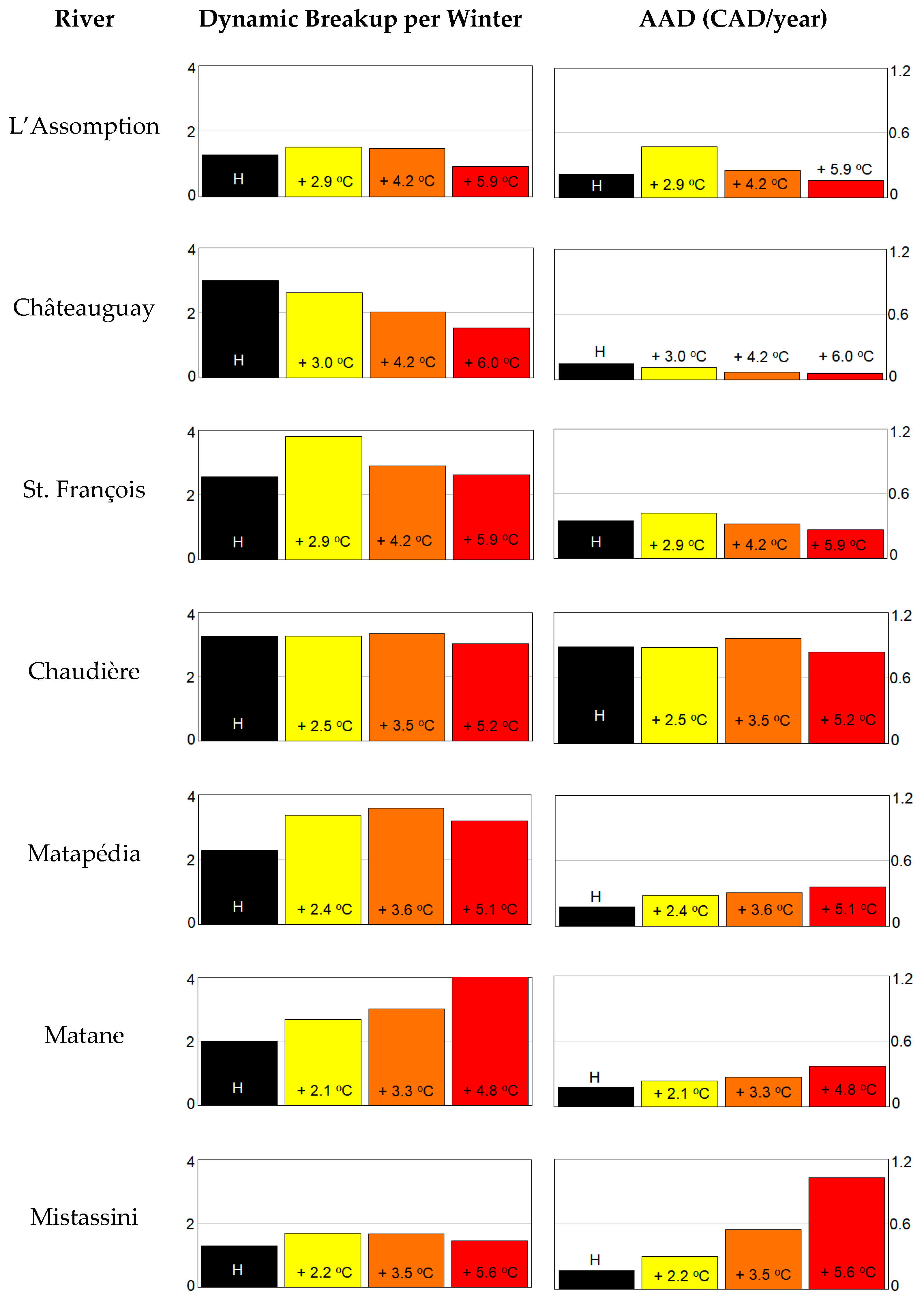
1. Introduction
Each winter and spring, river ice jams generate flooding and cause significant damage in Canada and in other cold countries of the world [
1]. These ice jams are mostly associated with dynamic river-ice breakup events, characterized by the rupture and mobilization of a resistant ice cover by a rapidly rising discharge (this is opposed to thermal river ice breakup scenarios that occur when the ice cover degrades and melts in place for several days to weeks before its disintegration) [
2]. The occurrence of a dynamic breakup event in a specific watershed, and the intensity of resulting ice jams, forming when a section of mobilized ice cover (the ice run) encounters a downstream obstacle (e.g., a thick ice cover or ice accumulation, bridge piers), a congestion point (e.g., an island or a narrow), or an energy dissipation location (e.g., a channel widening or a slope attenuation) [
3], depend on multiple hydrometeorological parameters, e.g., [
4]. Simply stated, the combination of a competent ice cover subject to a significant increase in runoff (caused by high snowmelt rates or an intense rain event) is the normal scenario leading to an ice jam flood.
Ice jam floods tend to occur very fast compared with open water floods, with water levels rising by more than a meter in less than an hour, e.g., [
5] and with water levels reaching elevations that are several meters above the open water rating curve, e.g., [
2]. Moreover, resulting high water levels can persist for several days, and if the ice jam is the result of a mid-winter breakup event (i.e., usually a rain on snow event), the flooded area can freeze after the return of cold weather, which significantly complicates post-event recovery. As a result, there is a significant interest in being able to predict ice jams. This need has led to the development of several river ice models, e.g., [
6,
7], some of which could be used to design (and to confirm the financial benefit of [
8]) flood control measures [
9,
10].
If ice jams and their impacts can be predicted with some degree of accuracy in the short term, public safety services, hydropower agencies, insurance companies and transportation infrastructure managers may also wonder about long term projections. More specifically, stakeholders could have an interest in being informed about the impact of a changing climate on the frequency and severity of ice jam floods, and therefore on their future activities and investments. The media covering ice jam flood events often ask what role did climate change play. River ice experts consider this to be a good question, in part because there is not much literature on the topic, e.g., [
4,
11,
12].
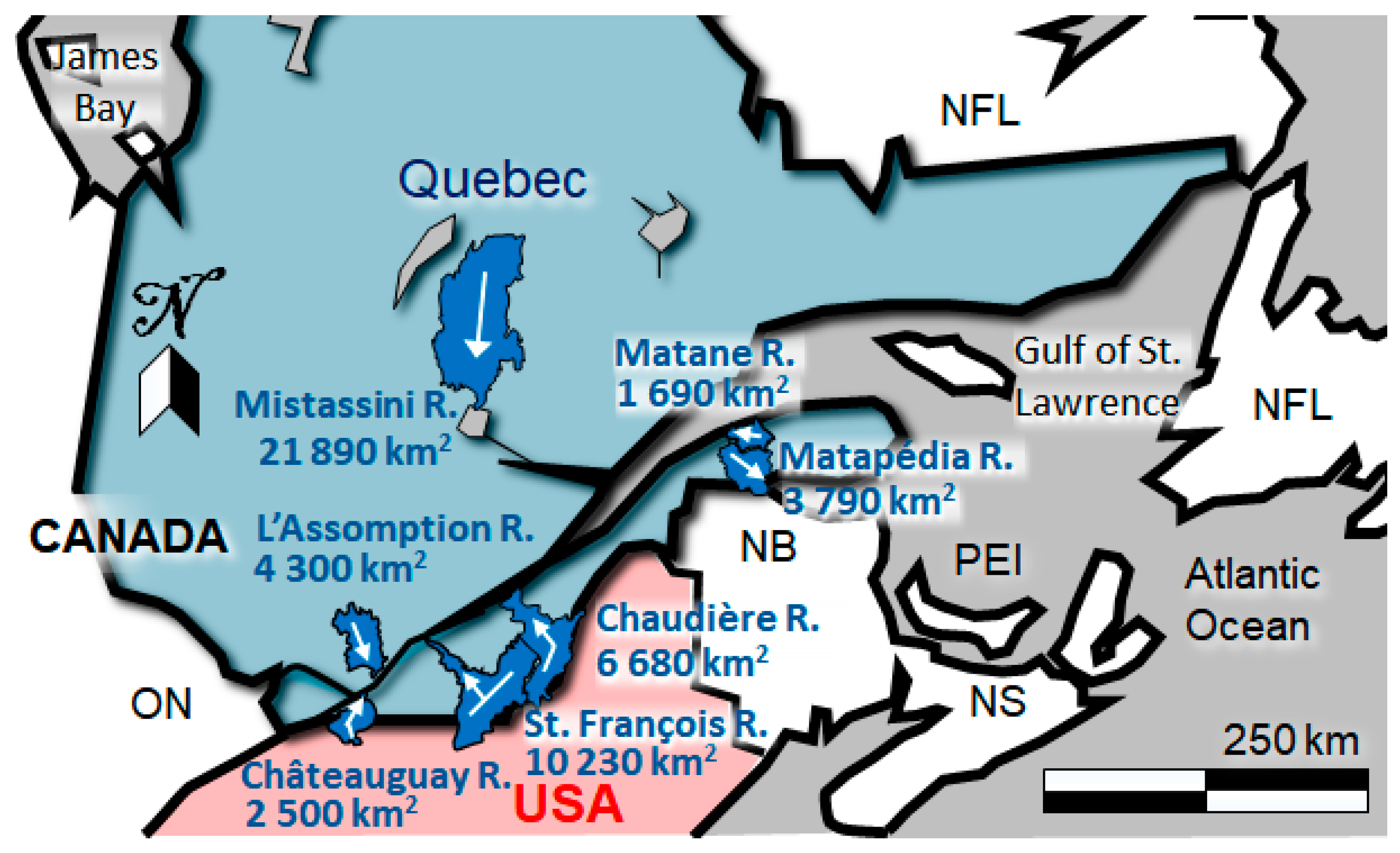
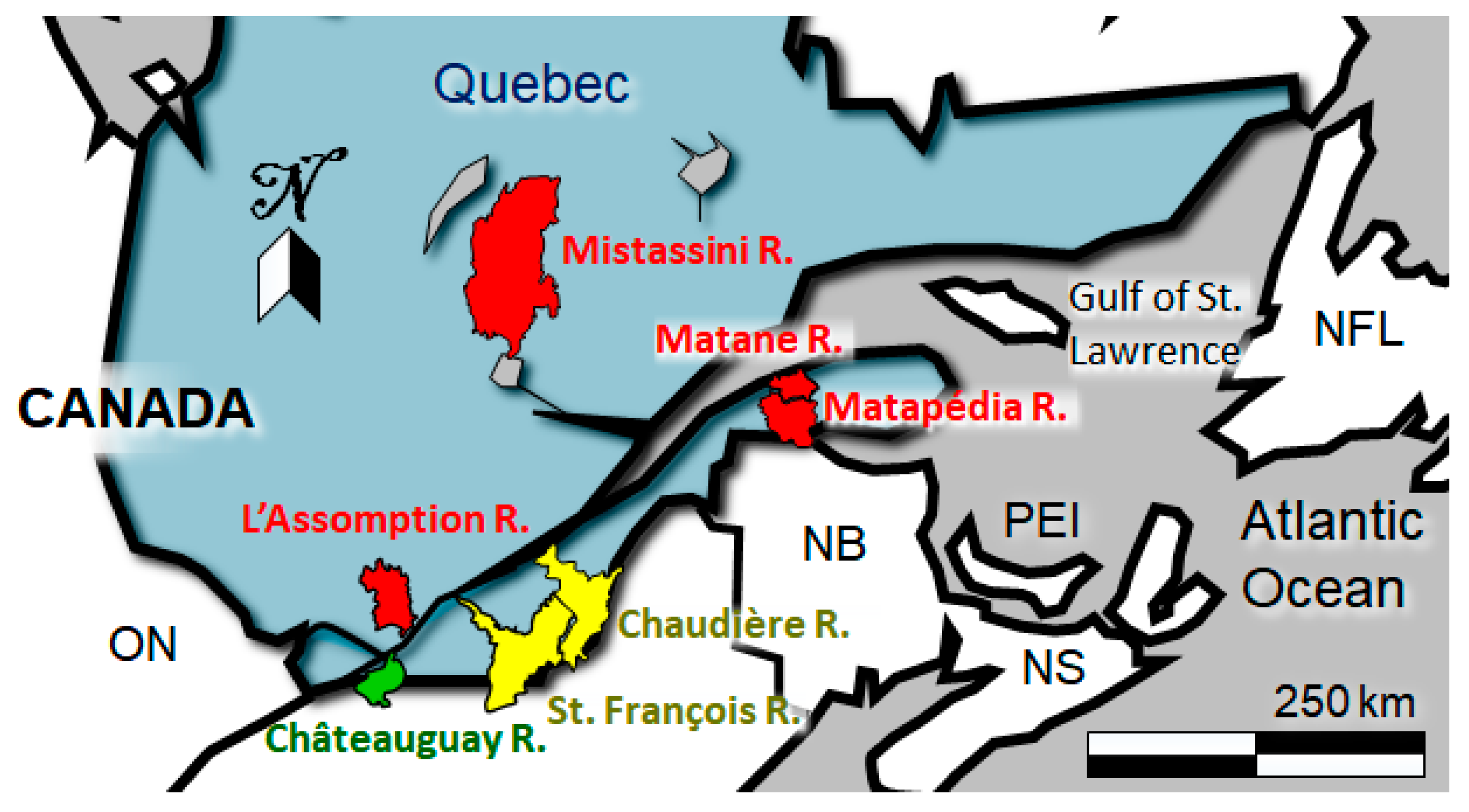
In the province of Quebec, Canada, where ice jam floods are common [
1], observations made by the authors since 2010 in watersheds located both on the north and south side of the St. Lawrence River suggest that winter and spring meteorological conditions are becoming more unstable, both in terms of amplitude and frequency. Recent weather is conducive to more frequent (1) mid-winter, partial breakup events [
13] (some mid-winter ice jams remain in place until spring breakup) followed by significant frazil ice production (e.g., January 2010 and 2018, February 2013, December 2018) and (2) spring breakup ice jams (severe March 2012 air temperatures anomaly, important rainfall in April 2014, 2016, and 2019). It seems that the combination of altered river-ice breakup driving or resisting factors and winters that would, overall, remain cold enough to generate an ice cover on rivers located north of Montreal, Quebec, would produce more frequent ice-jam floods and generate more damage in the future. This hypothesis is based on observations, judgement and the literature [
11,
12], and it led to the study reported here.
The objective of this paper to quantify the impact of climate change on ice jam floods in Quebec. Since provincial stakeholders and authorities have an interest in comparing the frequency and financial risk of historical and future dynamic river-ice breakup events along rivers that are prone to severe ice jams, they requested and supported this research.
2. Background
It may be perceived that global warming will eventually prevent river-ice formation and therefore progressively eliminate the risk associated with ice jams on an increasing number of northern rivers. However, in addition to higher rising average winter air temperatures, climate change also alters precipitation patterns and, more generally, increases weather variability [
14]. It was anticipated by river ice experts that ice conditions would not simply become more benign as cold regions warm up, e.g., [
15]. An increase (or a decrease) in the occurrence of ice-jam floods would, in part, depend on whether hydrometeorological fluctuations driving breakup can dominate (or not) over ice-weakening caused by an average rise in winter air temperatures.
Trends and projections of different meteorological and river-ice parameters that affect the occurrence of ice-jam floods in Canada have been reviewed [
4,
12]. It seems that rising winter and spring temperature trends (1948–2016) are weaker in some areas of Eastern Canada compared with the national average [
11], and a similar interpretation can be made about the evolution (1948–2012) of average winter and spring precipitation [
16]. Beyond the changing duration of the ice season and maximum thickness of ice covers on lakes and rivers, as reported by several authors, e.g., [
13,
17], the effect of climate change on the frequency and intensity of ice jams still remains largely anecdotal.
Different methodologies can be used to estimate how the changing climate will affect the frequency and intensity of ice-jam floods in Quebec over the 21st century. Three approaches proposed in the literature [
4] are likely to provide tangible quantitative results. Interestingly, the simplest approach, which is the statistical analysis of the trend of historical ice-induced maximum water levels, has not yet been widely applied in Canada (two examples for the Athabasca River and for the Yukon River are presented in [
4]). This is probably because, at least in part, there are gaps in many historical hydrometric records across Canada [
18], especially during high water events. Hopefully, the pioneering work that consists in extracting meaningful information from 196 hydrometric station historical winter records to create the Canadian River Ice Database (CRID) [
19] will facilitate the application of this first approach in Quebec, as well as in other parts of Canada.
Another approach proposed in [
4] is to compare the breakup regime of two rivers of comparable size and profile, one in the region of interest, and the other in an area where the current climate is representative of the future climate in the area of interest. This approach has apparently not been applied yet, but there are already some insights about its potential: It was suggested that meteorological patterns in southern Quebec would eventually compare to what currently prevails in Pennsylvania and New Jersey [
20]. The United States (US) Army Corps of Engineers Ice Jam database [
21] reveals that the number of ice jams in the Northeastern US follows a declining trend in recent decades. Observations from the Northeastern US [
22] also propose that the short duration and low intensity of cold periods combined with dominant above-freezing temperatures and more frequent rain events are preventing the formation of a complete ice cover at an increasing number of locations and, as a consequence, breakup scenarios are becoming more thermal. However, intense ice jam events are still happening in watersheds located just south of Quebec, especially during the mid-winter period [
23,
24]. In addition, and although the climate transposition may not be as representative, it was found, using empirical thresholds, that mid-winter and spring breakup ice jams in Midwest US were becoming less frequent, but potentially more intense [
25].
A third approach, applied in this paper, involves using different types of river-ice models to simulate historical (for calibration and testing) and future breakup or ice-jam events. This approach depends on the availability of reliable meteorological data, hydrological data, and ice-related data (e.g., water levels) or observations (e.g., confirmed ice-jam events). It was applied on three rivers of Midwest US [
25], but only for hindcasting. In recent years, the University of Saskatchewan has produced key papers relying on this approach. The MESH hydrological model [
26] and the RIVICE numerical river-ice model [
27] were used to simulate water levels associated with future ice jams on the Athabasca River at Fort McMurray, Alberta, Canada [
28]. This approached was applied to ensembles of ice-jam water levels to generate the future 100-year return period flood delineation for Fort McMurray [
29]. The results suggest that ice-jam floods will become less frequent at Fort McMurray during the period of 2041–2070 compared with a baseline period of 1971–2000. Interestingly, it had been mentioned [
30] that extreme events could still happen at that location, which was indeed the case during the spring of 2020.
A wide range of hydrological and river-ice jam (or river-ice breakup) models can be used through this approach. In addition to MESH, other hydrological models may include CHM, e.g., [
31]; GEM Hydro, e.g., [
32]; Raven, e.g., [
33]; or HYDROTEL, e.g., [
34]. In terms of river-ice models, new versions of HEC-RAS [
35] are now adapted to run a sequence of multiple ice-jam scenarios efficiently (e.g., for ice-jam flood mapping, e.g., [
36]). River-ice breakup and river ice jam models have been listed in other publications, e.g., [
6,
7,
29,
37]. In terms of historical ice jam data, the
ministère de la Sécurité publique (Ministry of Public Security, MSP) of the Quebec Government maintains its own ice-jam database, the Government of Canada is working on developing a federal ice-jam database [
38], and, as stated above, ice-jam data can be extracted from the CRID recently released by Environment and Climate Change Canada [
19].
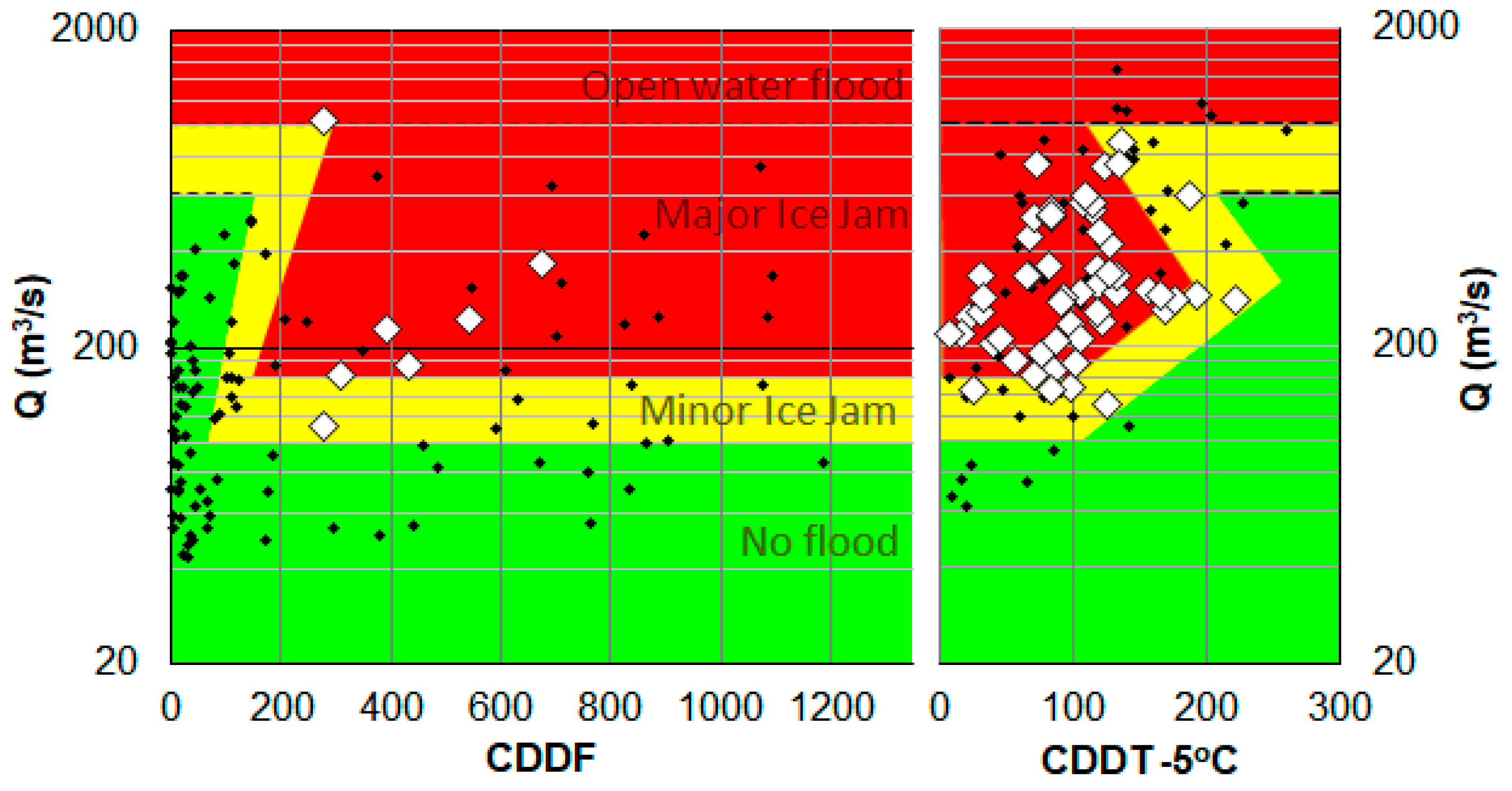
Evaluating the risk of a hazard involves combining its probability and consequences. The level of consequence is generally proportional to the hazard intensity. A common approach to quantify the flood risk is to multiply a site-specific or synthetic stage-damage curve, e.g., [
39] by a local stage-frequency curve. Even if they occur regularly, generate significant damage, and depend on evolving weather patterns, to the authors’ knowledge, the risk of ice jams floods in a changing climate has not yet been estimated in any area of North America.


