Article

Improving Water Quality in the Wet Tropics, Australia: A Conceptual Framework and Case Study

1
Forestry Department, New Mexico Highlands University, P.O. Box 9000, Las Vegas, NM 87701, USA
2
School of Earth and Environmental Sciences, College of Science and Engineering, James Cook University, Cairns QLD 4870, Australia
3
Faculty of Environmental Sciences, Czech University of Life Sciences Prague, 165 00 Prague, Czech Republic
4
ARC Centre of Excellence for Coral Reef Studies, James Cook University, Townsville QLD 4811, Australia
5
Centre for Tropical Environmental and Sustainability Science, College of Science & Engineering, James Cook University, Townsville QLD 4811, Australia
*
Author to whom correspondence should be addressed.
Water 2020, 12(11), 3148; https://doi.org/10.3390/w12113148
Submission received: 28 August 2020 / Revised: 30 October 2020 / Accepted: 3 November 2020 / Published: 10 November 2020
(This article belongs to the Section Water Resources Management, Policy and Governance)

Abstract

:
The Wet Tropics region of north Queensland contains the highest biological diversity in Australia, has outstanding environmental values, is economically important and located adjacent to the Great Barrier Reef (GBR). Increasing urban development and agricultural intensification in the Wet Tropics has raised serious water quality concerns. To successfully achieve water quality improvement outcomes, the integration of social and biophysical knowledge, in particular clarifying the roles and responsibilities of multiple stakeholders for knowledge integration, has been identified as a key issue and research priority. However, research into the processes supporting knowledge integration and clarifying roles and responsibilities of multiple stakeholders for improving water quality is largely lacking. To fill this gap, we further developed and advanced a social-ecological planning framework to improve our understanding of how multiple-stakeholders can contribute to successful water quality management outcomes. Our conceptual framework, applied in the Tully basin adjacent to the GBR: (1) provides a transdisciplinary approach; (2) enhances the integration of social and biophysical knowledge through tailored methods fitting the local context; (3) shares knowledge and provides recommendations; (4) outlines factors that may promote or inhibit the implementation of freshwater quality objectives; (5) highlights inadequacies of existing government guidelines, policies, and presents co-management opportunities and (6) offers a novel collaborative approach supporting water quality improvement in the Wet Tropics of Australia and beyond.

1. Introduction

The Wet Tropics region stretches approximately 500 km along the north-eastern coast of Queensland and forms a belt approximately 50 km wide (Figure 1). The region has exceptional environmental values and high economic importance [1]. World Heritage status was established for some 900,000 ha (48%) of the area in 1988, which borders the Great Barrier Reef (GBR); creating a unique setting where two World Heritage Areas (WHAs) meet (Figure 1) [2,3].
Water quality degradation, contested uses and values of resources, climate change and urban growth put significant pressures on the protection, management and conservation of the Wet Tropics and the GBR WHAs. In response, one of the top national conservation priorities for the Australian Government is to help local communities rehabilitate and better protect coastal basins and critical aquatic habitats in the WHAs of the Wet Tropics and the GBR [3,4].
The Tully basin in the Wet Tropics has been identified as one of the top ten pollution hot spots in the GBR lagoon [3,5]. The Tully basin includes the Tully River, the Hull River, coastal tributaries and the Murray River, all draining into the GBR. Agricultural production is a major economic livelihood in the basin. Issues identified include in-stream water quality degradation in freshwater reaches from runoff from pesticides, nutrients and sediments leaving agricultural, but also industrial and urban lands. Other implications include drinking water impairments, fish kills, and losses of cultural, aesthetic, biological and recreational values [3,6]. Further urban growth and agricultural intensification is likely to increase water quality concerns in freshwater waterbodies and downstream marine environments [7].
Subsequently, a Water Quality Improvement Plan (WQIP) was developed for the Tully basin in 2008 to reduce sediment, nutrient and pesticide loads for waters entering the GBR. The 2008 WQIP was developed with industry and community members (including Traditional Owners) over a three-year period to establish local environmental values (EVs), and Water Quality Objectives (WQOs) targeted for estuarine, marine and selected freshwater parameters in the Tully WQIP area with the overarching aim to improve GBR water quality. This plan was endorsed by the local community [5]. In addition, a Wet Tropics WQIP 2015–2020 was recently completed (at a larger scale) to provide a regionally consistent approach to water quality improvement for Wet Tropics catchments and the GBR [3]. WQIPs are an important part of the Australian and Queensland Government’s Reef 2050 Water Quality Improvement Plan 2017–2022 (The Reef 2050 WQIP) [8].

1.1. Environmental Values, Relevant Guidelines and Water Quality Objectives

Identification of Environmental Values (EVs) forms an important part in the development of WQIPs. EVs are the communities’ preferred uses and values of local waterbodies (including drinking water, aquatic ecosystems, water for farm use, spiritual and cultural values). Schulz et al. also state that “better knowledge of environmental values can contribute to better design of incentives for pro-environmental behaviour including environmental policy.” [9] (p. 212). EVs for waterways are found in Queensland Water Quality Guidelines 2009 (QWQG) [10].
The National Water Quality Management Strategy (NWQMS) [11] and the QWQGs [10] categorise EVs of waterways into “a suite of categories to include aquatic ecosystems, primary industries, recreation and aesthetics, drinking water, industrial uses, and cultural and spiritual values. Some of these categories are further stratified [2].
Ecological protection guidelines have been developed for many different water types (upland streams, lowland streams, wetlands, lakes estuaries and marine), and some nutrient and physiochemical guidelines (suspended solids, turbidity) have been developed for different climates/regions within Australia. These recommended default guidelines are to be used if no locally derived guidelines are available. The Tully, Murray and Hinchinbrook Island River Basins EVs and WQOs [12] are currently the most relevant to apply to the Tully Basin, but these guidelines/trigger values are not available for all parameters [13,14,15]. The list of EVs for the Tully Basin are in Table A1, Appendix A.
The QWQGs (2009) state that where sub-regional (i.e., more localised water quality guidelines are available; they are to be given precedence) [10]. Additionally, the development of these sub-regional guidelines should be consistent with the NWQMS, embedded in the 1997 Queensland Environmental Protection Policy (QEPP), and approved by EPA and GBRMPA [5]. According to the State Department of Environment and Heritage Protection [10], developing and improving water quality guidelines is considered to be an ongoing process.
WQOs are “water quality levels (i.e., the concentration of water pollutants) that, if achieved and maintained, would protect the communities preferred EVs” [5] (p. 17). WQOs are based on “relevant state and federal water quality, drinking water, and recreational water quality guidelines and standards (to protect EVs) as well as on the community’s choices for EVs” [5] (p. 17).
However, the Tully WQIP was focused on developing downstream WQOs for estuarine and marine environments including the GBR. No WQOs for freshwaters (except selected pesticides) were developed. Marine ecosystem targets were linked to end-of-river pollutant load targets and to farm-level management practice targets to establish management actions for water quality improvement in the basin [16]. Targets were defined as quantifiable performance levels or changes in levels to be attained at a specific future date [16].
The Tully WQIP defined aspirational targets for water quality parameters as draft WQOs in marine waters, and aspirational targets for selected herbicides as draft WQOs in all waters (marine and freshwater). No other water quality targets were developed in this basin for freshwater parameters as draft WQOs [5]. Refining WQOs for freshwaters in the Tully basin could potentially be used to establish processes to improve or restore basin water quality conditions, and community uses and values of basin waterways [17]. Therefore, refining WQOs for freshwaters in the Tully basin was critical since they have not been fully developed in the Tully basin [18].
Through the Tully 2008 WQIP community consultation process, several local water quality issues of concern (relevant to freshwater reaches) were also identified. These concerns include the safety of drinking water, limited or no access to areas of cultural and spiritual significance, and loss of local waterbodies including wetlands, lagoons and small streams [19,20].
During the Tully WQIP process, interviews and workshops with members of the local community supported setting water quality objectives (WQOs) for the freshwater reaches to protect the community’s environmental values (EVs) and uses [3,21,22]. The WQIP recommended additional consultation with the community to develop freshwater WQOs, as the Tully WQIP was mainly focused on developing downstream WQOs for estuarine and marine environments including the GBR [5].

1.2. Rationale for Selecting the Tully Basin as the Case Study for this Research

In addition to the recommendations stated in the Tully WQIP, we chose the Tully basin as a case study for this research as it is biophysically and economically representative of other Wet Tropics basins in the region and is draining into the GBR lagoon (Figure 1). In addition, the Tully River is the least variable river in the Wet Tropics with respect to annual discharge and allows for accurate and defined water quality trends [3,23]. The Tully basin also represents the wet tropical climate of the region [24] and is characterised by high, summer dominant rainfall (average 2000–4082 mm). The Tully basin covers an area of 2787 km2, draining wet tropical rainforest in its upper reaches [25]. The basin’s middle and lower reaches contain beef grazing, and a large coastal floodplain is comprised of wetlands modified to support sugarcane and banana production as well as urban areas [5,24,26,27]. Approximately 65% of the Tully basin is located in the Wet Tropics WHA (Figure 1) [5,26].
Main land uses include natural forest (71%), sugarcane (13%), grazing (5%), plantation forestry (4%), banana and other horticulture (3%) and urban (1%). The remaining 3% are waterways [27]. According to Brodie et al. [27], the landscape of the Tully basin has been significantly altered since European settlement, including reductions in areas of floodplain vegetation (~80%, to 20.8 km2), riparian areas (~60%, to 59 km2), and wetland areas (~69%, to 72.5 km2). These floodplain alterations and clearing of forests for agricultural development have changed local hydrology and drainage patterns [3,27].
As of July 2020, the Tully River basin had an estimated resident population of 11,195 persons [28]. Three Aboriginal Traditional Owner groups live in the area including the Girramay, Jirrbal and Gulnay people [5]. The Girringun Aboriginal Corporation, an indigenous community-based organisation in the region, represents the interests of these Traditional Owner groups in the basin. The Aboriginal Corporation has expressed a desire to recognize the Tully basin as an Indigenous Protected Area (IPA), thereby creating opportunities for Traditional Owners to be involved in monitoring, protecting, co-managing water resources (freshwater and marine), assisting with enforcement measures, and creating future research opportunities in the area [20].

1.3. Community-Based Natural Resources Management

Gruber [29] and Carlson and Cohen [30] state that community-based natural resource management is a valuable governance approach for sustainability to better manage common resources. This approach emphasises the role of communities to assist in making decisions about resources. Some community-based programs have become established to focus on the empowerment of local communities [29,31,32]. Successful environmental outcomes for common resources (such as water quality improvements to local waterways) may lie in the ability to successfully integrate different kinds of knowledge (e.g., scientific and local knowledge) to create new knowledge while encouraging social and collective learning and building key partnerships [33,34,35,36,37,38].

1.4. A Transdisciplinary Research Approach

Everly et al. [39] state that there have been improvements to better understand social processes and phenomena in relation to environmental planning and management that link the work of social and biophysical sciences. However, there has been limited integration of these disciplines. Greater recognition has recently been placed on the use and contribution of transdisciplinary approaches to help understand complex environmental issues [30,32,33,39,40]. Transdisciplinary research is defined as studies that involve academic researchers as well as non-academic participants such as land managers, user groups and the general public to create new knowledge and theory to research a common question [41,42]. Knowledge integration and translation has expanded from a ‘rational’ scientific approach to encompass local knowledge and informal institutions to inform planning and management decisions [43]. Researchers have promoted the active participation of stakeholders from the beginning of the research process [2,30,32,33].
The integration of social and biophysical knowledge has been identified as one of the key issues and research priorities for successful water quality improvement outcomes [34,35,36,37,38]. The integration of this knowledge has gained widespread recognition in water quality planning and management for its potential to inform management plans and gain community support for these actions [19]. Scholars have established that communication and collaboration between scientists (from different backgrounds), planners, administrators, and local stakeholders is essential, and supports the integration of social and biophysical knowledge [33,35,36,37,38].
Brodie et al. [34] stated that a transdisciplinary approach can also assist in better understanding of the social-biophysical catchment to the Great Barrier Reef system processes by providing an overarching structure that has the capability to integrate knowledge, encourage social and collective learning and build key relationships [43].
Natural and cultural values are “inherently linked and Indigenous involvement in natural resources management is essential in maintaining culture” [44] (p. 190). The Millennium Ecosystem Assessment (2005) identified that cultural values and services is seldom acknowledged within landscape planning and management processes, and a better understanding is needed to identify how changed landscapes and ecosystems are linked to changes to communities’ cultural, spiritual and religious belief systems. Cullen-Unsworth et al. [45] state that “greater attention needs to be given to the protection of landscapes especially in areas where biodiversity and cultural practices are linked” [45] (p. 183). Additionally, a better framework needs to be developed to identify “linked cultural and biophysical indicators to be used at local and regional scales in routine monitoring and management” [45] (p. 185). By using a cooperative research approach, “appropriate indicators could be developed to monitor cultural heritage values of ‘country’ and indicators could potentially be coordinated with or integrated into existing local, regional, national and international reporting frameworks” [45] (p. 191).
Understanding spiritual and cultural values of waterways and incorporating them into water resources planning, policy and management frameworks is as important as understanding the other values of waterways (e.g., hydrologic and ecological values) [45]. Often, there are no clear or consistent stakeholder engagement policies and delivery frameworks from local, State and Federal governments to contribute to an improved integrated and effective approach to water quality planning and management [46]. There has been little opportunity for indigenous participation in developing water quality objectives (WQOs), and managing water resources [47]. In addition, there is little guidance in Australia and elsewhere for water resource managers and agencies to recognise indigenous access and involvement in water resources issues [47,48].

1.5. Social-Ecological Planning for Improving Water Quality

Based on a holistic concept of landscape, representing the relationship between people and place [49] and the idea that dialogue and public participation are essential in the debate about possible future landscape developments [50], Bohnet and Smith [2] developed a social-ecological framework for planning future landscapes in the Wet Tropics. This framework incorporates a range of planning methods, including participatory tools, such as maps and landscape visualisations, and processes, such as the involvement of local communities in the development of alternative landscape scenarios. Application of this framework in two case study areas proved to be effective in building social capital in the region in relation to planning and local development, and of building capacity for participation in planning processes. It also highlighted the communities’ interest in learning more about predicted effects on water quality of different land use and management change scenarios [51].
Tailored application of this framework in the nearby Tully basin supported development of the Tully WQIP [19], while highlighting a number of issues requiring further research attention [19,35,52]. Building on these findings as well as drawing on frameworks and experiences from Australia and Europe in relation to enhancing implementation of local management actions for improving water quality [53,54,55] we continued our research efforts in the Tully basin.
The overall aim of our research was to build on and advance the social-ecological framework applied in the Tully WQIP planning process [35] to support improving water quality conditions in the Tully basin. In particular, we focused on the roles and specific activities of multiple-stakeholders to support knowledge integration and implementation of measures for improving water quality conditions [18]. Joint design and implementation of a pilot water quality monitoring program by scientific and non-scientific stakeholders in the Tully basin proved to be a critical, yet missing, component in the conceptual framework that can significantly influence the implementation of local management actions to improve water quality.

2. Materials and Methods

2.1. A Conceptual Framework for Revising Freshwater Water Quality Objectives (WQOs) in the Wet Tropics

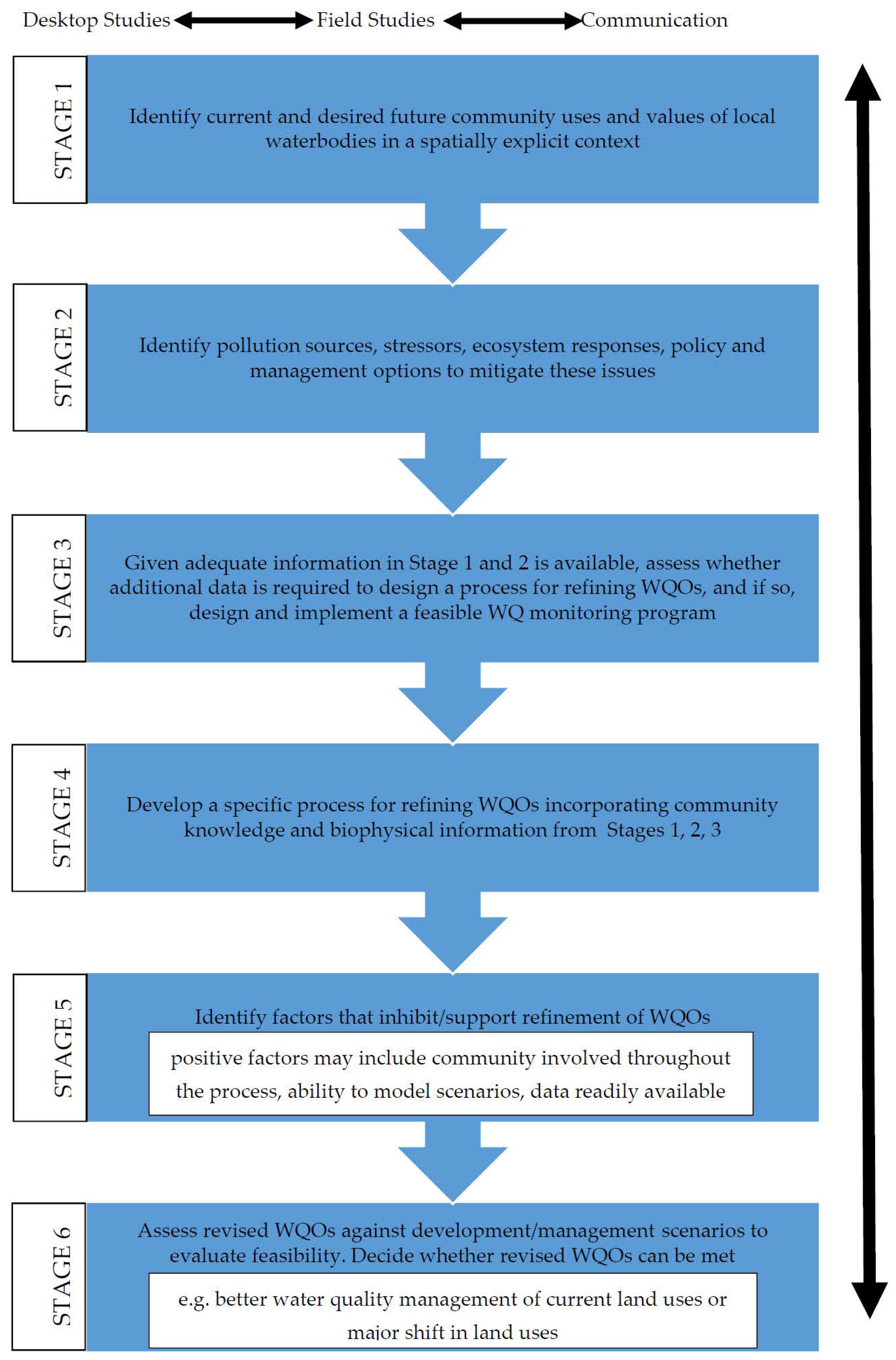
A conceptual framework was developed for the refinement of freshwater WQOs in the Tully basin. The framework links social and biophysical knowledge and supports collaboration between diverse stakeholder groups (Figure 2). The conceptual framework outlines the essential steps for integrating multiple uses and values of local waterbodies and spatially explicit biophysical data into refining freshwater WQOs. The conceptual framework builds on existing planning frameworks [2,35] and addresses important questions, such as the role and relevance of systematic (scientifically derived) and local (derived from experience and familiarity with local conditions) knowledge for making decisions [52]. It includes a range of applied biophysical and social science methods and processes, such as the involvement of local communities in the development of a pilot water quality monitoring program. Inclusion of design and implementation of a feasible water quality monitoring program in the conceptual framework proved to be the critical mechanism supporting collaboration between scientific and local knowledge holders, local leadership, and knowledge building and brokerage [53].
A range of tools and processes can be applied in each of the stages of this conceptual framework. Community involvement is recommended throughout the framework with different tools and processes suggested for each stage. The process is not unidirectional as illustrated in Figure 2; there is potential for feedback loops and reasons for iterative processes within and between different stages. In each stage, a combination of desk studies, field studies and communication are suggested, and are not always distinct tasks as shown in Figure 2. They often inform each other and may overlap depending on the task [2,22].

2.2. Application of the Conceptual Framework in the Tully Basin, Queensland, Australia

2.2.1. Stage 1 of the Conceptual Framework

Stage 1 used the Tully WQIP [5] as a basis to verify environmental values (EVs) previously listed in the Tully WQIP [5], documenting any EVs not listed, communicating stakeholder interests in basin water quality issues, and providing knowledge to inform the processes needed to refine water quality objectives. Further, meetings with key informants in the basin were also part of Stage 1. A two-staged participatory approach included personal interviews with key stakeholders and community workshops was implemented to engage basin stakeholders in this research. Key stakeholder groups were identified as they have the greatest potential to influence water quality changes. Stakeholder groups included Traditional Owners, local residents, farmers, and general community members.
Ethics approval was obtained by the James Cook University Human Research Ethics Committee (HREC) in accordance with the Australian National Statement on Ethical Conduct in Human Research (2007–2018). Interview and community workshop data were anonymized, and statements of informed consent was obtained by all participants.
An Informed Consent Form was given to all interview participants, and all participants signed the Consent form before the interviews began or any photographs were taken. All the identifying information from the interviews was designed to be confidential and remain confidential. No names were used without the permission of the participants. We ensured that the raw data from this study have been stored in a secure location and raw data will be destroyed when they are no longer needed as per James Cook University Human Research Ethics Committee Guidelines.
Before interviews and workshops were conducted in the Tully Basin, we met with key informants in the basin to discuss the objectives of this research, gather important background information, gain additional information about basin water quality issues, and provide an opportunity to solicit and secure potential workshop participants and interviewees.
Key informant discussions were held with the CEO of Girringun Aboriginal Corporation (representing the interests of Traditional Owners from tribal groups in the basin), Traditional Owner elders (individuals who are most knowledgeable in terms of traditional knowledge and changes to country), researchers/scientists working on basin water quality issues, agricultural and industry representatives, community, government and conservation groups, representatives from local schools, representatives from the local natural resource management body (Terrain), local planners from the Cassowary Coast Regional Council, extension agents, and tourism operators. The key informant discussions were also important as these informants regularly attended and participated in other locally relevant basin meetings; they helped provide information about recruiting potential workshop participants/interviewees, and informed others about this research.
After the key informant discussions were completed, three workshops were held in the Tully Basin in three different locations; one at Girringun Aboriginal Corporation (Girringun requested a separate meeting for Traditional Owners), one in Euramo (a central basin location), and one at South Mission Beach (a coastal location) (See Appendix B, Figure A1, Figure A2 and Figure A3). Workshops were held in these locations to allow local people to attend a workshop in their local area. These workshops informed the basin community about this research and provided a forum to invite participants to be interviewed for this research. They also allowed participants to discuss their views and values with other workshop participants, be exposed to potentially different views, and learn from others.
All three workshops included attendees from the key stakeholder groups, including the CEO from Girringun Aboriginal Corporation, Traditional Owner elders from the basin, representatives from the local NRM body (Terrain), regional council staff (Cassowary Coast Regional Council), tourism operators, and locals representing local conservation organizations.
A series of basin maps and tables were used to help guide the community workshops (see Appendix B, Figure A1, Figure A2 and Figure A3). Maps and tables showed the previous environmental values (EVs) identified for each river reach (from the 2008 Tully WQIP), and additional maps showed land use information and locations of water quality monitoring stations in the basin. By providing this information as a starting point for discussion, workshop participants were able to discuss issues, values, and ideas for water quality monitoring in a ‘spatially explicit’ context.

2.2.2. Stage 2 of the Conceptual Framework

Stage 2 of the conceptual framework focused on an extensive literature review to describe the current water quality degradation of coastal waterways in the Wet Tropics and summarize the current level of water quality knowledge in the Wet Tropics. Stage 2 provided current anthropogenic disturbance and coastal waterway conditions, environmental management regimes and an overview of existing planning frameworks and processes, water quality standards, statutory and voluntary guidelines and sources of stressors resulting from key land uses. This key biophysical information also provided a summary of stressors and sources resulting from key land uses that linked pollutant sources, stressors, freshwater ecosystem responses, management actions, and its effectiveness to describe overall water quality degradation of coastal waterways in the Wet Tropics [18].

2.2.3. Stage 3 of the Conceptual Framework

Stage 3 was mainly based on findings from stages 1 and 2 and focused on assessing whether additional data were needed to design a process for refining WQOs in the Tully Basin. More detail is provided in subsequent sections.

2.2.4. Stage 4 of the Conceptual Framework

Stage 4 focused on developing specific processes for refining WQOs, incorporating knowledge gathered from stages 1, 2 and 3. First, we developed a master list of potential interviewees to be consulted. The list was designed to include interviewees from different parts of the basin and diverse social status (gender, age, broad occupational status, and length of time lived or worked in the basin) [11]. In addition, we used a snowballing technique, where one person in the community introduced the researchers to others, which provided researchers with access to interviewees that may have otherwise not participated [19,56]. This type of sampling is applied where the purpose behind the sampling is theoretically defined. In this case, the sample was stratified geographically and socially. This technique expanded upon previous work that had been done in the Basin prior to this research [19,57].
From previous work conducted in the Tully WQIP (using a checklist of possible water interests provided in the National Water Quality Management Strategy 1998), and the stakeholder mapping exercise for the Tully WQIP, interviews were designed to be primarily conducted with the Tully basin community (i.e., people living in the geographical area covering the basin), but also expanded to include researchers and government agency folks working directly on basin water issues. As stated previously, the stakeholder mapping exercise in the Tully WQIP identified a “whole range of local community members representing varying interests and values including Traditional Owners, other indigenous people, farmers, industry, non-farming residents, conservation groups and the concerned public” who should be involved and represented in the research [21,22]. Girringun Sea Country Aboriginal Rangers provided the researchers with valuable assistance in recruiting Traditional Owners to participate in the interviews and workshops for this research. Additionally, the Canegrowers Association in Tully also gave the researchers office space to work out of while they were in the Tully Basin, so researchers could conduct interviews in a central location with the basin community.
In total, 124 personal interviews were conducted with the main stakeholder groups. From previous (2008) work performed in the Tully WQIP (using a checklist of possible water interests provided in the NWQMS 1998), and the stakeholder mapping exercise for the WQIP, interviews were designed to be primarily conducted with the Tully Basin community (i.e., people living in the geographical area covering the basin), but also expanded to include researchers and government agency folks working directly on basin water issues.
Stakeholder groups interviewed included Traditional Owners (n = 32), local residents (n = 31), farmers (n = 31) and general community members (n = 30). The aim was to interview a minimum of thirty individuals from each stakeholder group to compare interview responses between key groups, illustrate potentially diverse points of view, and provide local knowledge about water quality issues in the basin. The comparison of responses between key stakeholder groups was considered to be a key priority in the design of the questionnaire [57]. Interview participants were not randomly selected in this research. The main aim was to interview a representative number of individuals from each stakeholder group so that responses to interview questions could be compared to other key stakeholder groups. Therefore, a target of about 120 interviews in total was established (4 key stakeholder groups × 30 individuals).
The semi-structured face-to-face interview and combination with the basin map were selected as tools, as they can help contribute to social and biophysical knowledge integration and assist in building important relationships between the researchers and key stakeholder groups. The face-to-face interview was also selected to obtain a high response rate and probe for detail that may be difficult in telephone or mail surveys [58].
Interviews with Traditional Owners and other indigenous people living in the basin took place at peoples’ residences or at Girringun Aboriginal Corporation (where an office space had been assigned to conduct interviews). Interviews with local residents, farmers and general community members mainly took place at interviewees’ residences, farms or workplaces, or were conducted at the local Canegrowers office in Tully. An office space was assigned to the principal researcher at the local Canegrowers office so that interviewees could be interviewed in a central location if the interview was not scheduled at a residence, farm or workplace.
A basin map showing existing basin EVs from the Tully WQIP was also shown to interviewees during the interviews. Participants were asked to verify EVs previously identified from the Tully WQIP and to also identify any EVs missing from this process. Tables showing EVs for each sub-catchment were also made available. The use of basin maps was important as they visually showed the locations of previously identified EVs (from the Tully WQIP), and also provided a mechanism for interviewees to add any additional water uses and values in a spatially explicit context.
In addition, maps for each sub-catchment showed the main land uses and water quality monitoring stations. These maps were important during the latter stages of the interview questionnaire when discussing water quality monitoring questions. These mapping tools facilitated knowledge integration and fostered communication and sharing of local knowledge between the JCU principal researcher and the interviewee(s).
Interviews were tape recorded, notes taken, and responses documented. The interview data were put into a series of tables, systematically coded, and then put into an Excel database where this data could be analysed [57] (Appendix C). All information related to EVs and associated coastal and marine environments was coded according to the EV classification scheme provided by the Queensland Water Quality Guidelines (2009) [21]. Additional EVs identified by stakeholders that did not fit into the State classification scheme were also documented (Appendix C). Descriptive statistics were used to present results from the close-ended questions. To analyse the open-ended questions, major concepts were extracted from the interview data based on an interpretation of the content, codes were created to identify the expression of these major concepts, and then categorised by grouping common themes [59] (Appendix C). Results from the interviews were also shared with the basin community after all interviews had been completed. A workshop was held in a central location in the basin (Euramo) in 2012 to give interview participants an opportunity to view the interview results and provide feedback. All interview respondents were invited to this workshop and a flyer was emailed and mailed to all interviewees before the workshop.
In addition to the interviews, five additional community workshops were held in the Tully basin and included an assessment of key stakeholder perceptions of basin water quality conditions and existing monitoring programs, while also outlining main differences between these groups. Interviews and workshops were also designed to identify key waterbody pollutants from a community perspective, including source categories and basin hot spot areas.
The community workshops were held in a central basin location so everyone interviewed for the research could attend. The purpose of the workshops was to discuss preliminary results from the interviews, highlight main water quality issues from existing biophysical information in the basin, and discuss a rationale for designing and implementing a pilot water quality monitoring program using social and biophysical knowledge, while providing opportunities for stakeholder participation in the pilot program. A draft pilot water quality monitoring plan to fill in biophysical gaps (showing potential sampling sites and parameters to be sampled) was given to workshop attendees.
The workshops were well attended and consisted of farmers, local residents, Traditional Owners, Girringun Indigenous Rangers, and representatives from natural resource organizations and government agencies. In consultation with stakeholders from these workshops, the design of the pilot program was finalized (See Appendix B Figure A1, Figure A2 and Figure A3).

2.2.5. Stage 5 of the Conceptual Framework

Stage 5 of the conceptual framework focused on identifying potential factors that could support or inhibit the refinement of WQOs. These factors are discussed in subsequent paragraphs below.

2.2.6. Stage 6 of the Conceptual Framework

The final stage in the framework was outside the scope of this research; however, this stage provided opportunities to assess revised water quality objectives against development/management scenarios to evaluate feasibility.

3. Results

3.1. Community Values and Perceptions of Local Water Bodies

Key informant discussions, workshops and interviews with the wide range of Tully Basin stakeholders showed that community perceptions of basin water quality conditions differed between stakeholder groups, but despite differences in stakeholder perceptions, all groups agreed that additional water quality monitoring was needed for the Tully Basin to better characterise current water quality conditions and assist in refining water quality objectives [18].
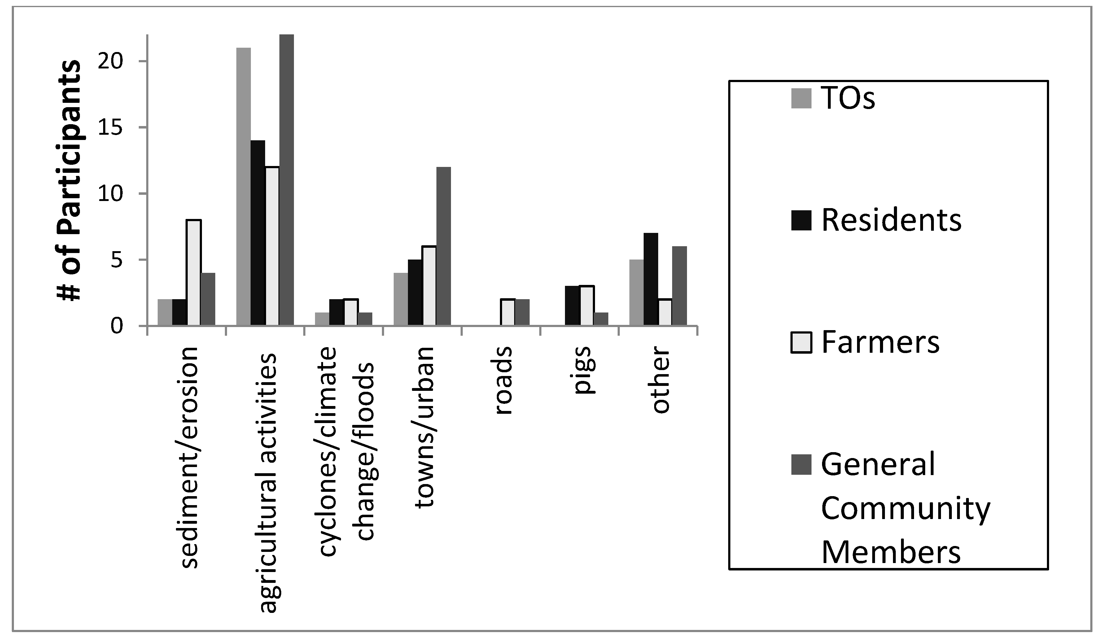
Interviewees also stated there were several sources and threats to basin waterways. Overall, findings showed that stakeholders had a range of views regarding their perceptions of water quality issues or pollutant sources in the basin. However, all stakeholder groups agreed that agricultural activities were sources of water quality issues or pollutant sources in the basin. These results informed the design of the pilot water quality monitoring program by helping to identify potential sampling station locations. In particular, in the community workshops, water quality sampling stations could be verified as well as parameters to be sampled.
Participants from all stakeholder groups specified that chemicals used in agriculture (e.g., pesticides) should be sampled as part of a monitoring program. In addition, Traditional Owners stated they would like to see fish and other aquatic life be sampled. This higher response rate by Traditional Owners may be due to their greater dependence on aquatic food sources to supplement their daily foods than other groups.
Interview results also highlighted potential human health concerns in the basin. Interview responses verified that a large percentage of stakeholders regularly drink untreated water from local waterways. If potential human health concerns or risks exist, e.g., high levels of pesticides found in the Tully waterways, regular water quality monitoring should be established, and locals should be appropriately informed of the results.
There was also agreement between stakeholder groups regarding who should be involved in a monitoring plan for this basin. All stakeholder groups suggested that a mix of participants should be involved in this program.

3.2. Biophysical Knowledge

A comprehensive review of biophysical knowledge for the Tully basin indicated that several water quality parameters exceeded state and federal guidelines, and some data gaps existed. Longer term water quality data were determined to be needed to ensure comprehensive basin coverage that encompassed different flow regimes, seasonality and to fill in water quality data gaps. Results from the literature review also verified that no comprehensive water quality sampling network in the basin was currently being monitored and water quality sampling was not consistently conducted across different seasons and different flow regimes. A long-term monitoring program to characterise water quality conditions over different flows and seasons is currently underway in the Wet Tropics, however, monitoring programs in the Tully Basin had mainly been directed at assessing impacts to the GBR with little or no attention given to the health of freshwater ecosystems [20,34].
The Tully Basin became part of the Girringun Region Indigenous Protected Areas (GRIPA) (8 June 2013). “The GRIPA works towards the Girringun vision of providing ‘social, cultural, spiritual, environmental and economic well-being of Traditional Owners and community members of Girringun for the benefit of the region” [60] (p. 1137). The GRIPA designation assists in providing opportunities for Traditional Owners to be involved in monitoring, protecting and co-managing water resources (both freshwater and marine) [61,62].

3.3. Rationale and Development for a Pilot Water Quality Monitoring Program

The results from stages 1 and 2 formed the rationale (stage 3) to establish a pilot water quality monitoring program for this basin.
  • Federal and State of Queensland Water Quality Guidelines: Australian Government guidelines state that locally relevant water quality guidelines should be developed for in-stream water quality protection. In addition, local authorities should use their own tools to better refine these guidelines, either by developing regional guidelines or developing specific local WQOs.
  • Tully Water Quality Improvement Plan (WQIP 2008): The basin community had issues of concern regarding freshwaters. The community supported setting Water Quality Objectives (WQOs) to protect Environmental Values (EVs) for freshwaters.
  • Water Quality Data and Reports Indicated Potential Water Quality Issues in the Basin. There was no comprehensive water quality sampling network in the basin. Current water quality sampling schemes were patchy; and did not consider seasonality and different flow regimes.
  • Workshops and Interviews from this Research. There were continuing community concerns about water quality issues, and input from the community indicated they would like to be involved in a pilot water quality monitoring program.
  • Key results from the interview data were compared to biophysical data for this basin. Social and biophysical results informed each other and indicated that additional data were needed to refine WQOs for this basin.

3.4. Development of a Pilot Water Quality Monitoring Program for the Tully Basin

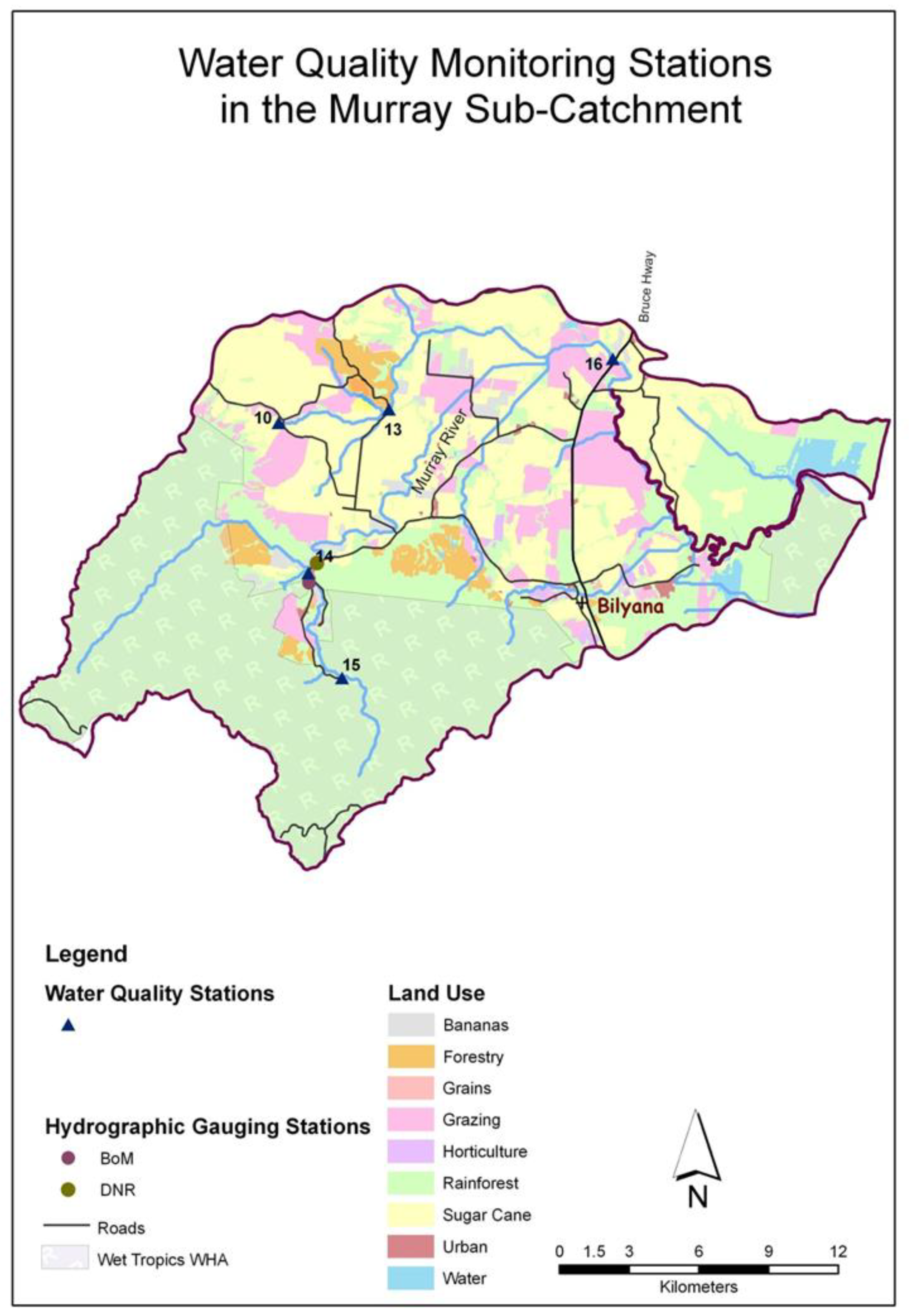
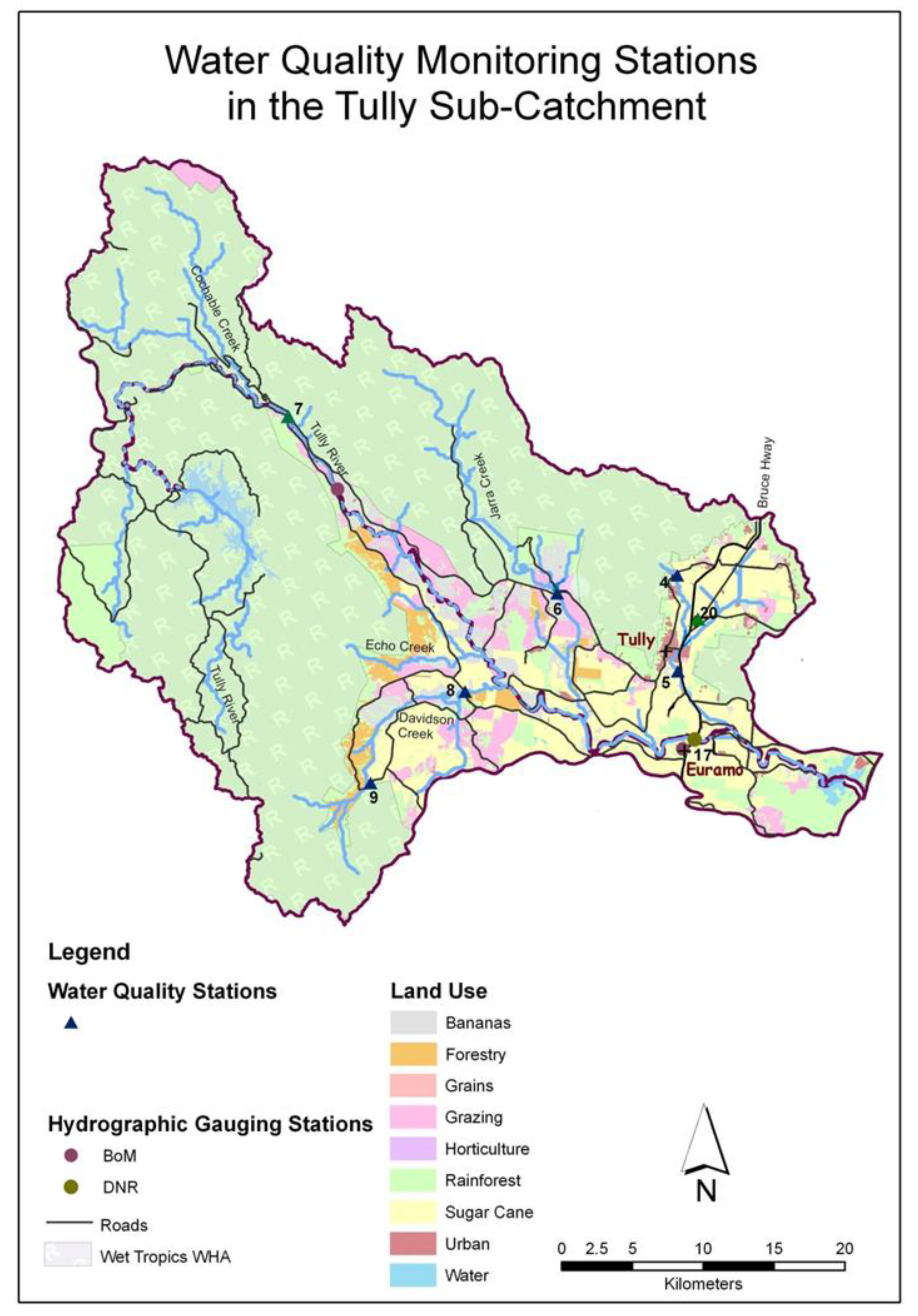
The pilot program verified whether a water quality monitoring plan could be undertaken by a local community group, allowed preliminary results to be discussed, presented opportunities and obstacles encountered during the pilot program, and identified recommendations for refining a long-term water quality monitoring program. A three-month timeframe was chosen (May–July 2012) to determine whether a community driven monitoring plan could be feasibly undertaken. This pilot program prioritised key water quality parameters and sampling locations (in consideration of interview responses by stakeholder groups, existing biophysical data and water quality monitoring stations), basin coverage and dominant land uses, safety, ease of sampling, budget, and feasibility. Sampling stations were also selected at specific waterbody locations draining subcatchments dominated by a single land use. Land use types included forest (rainforest), sugarcane, bananas (horticulture), grazing and urban (existing and lands being developed) (See Appendix B, Figure A1, Figure A2 and Figure A3). Although most subcatchments had a mixture of land use types, it was expected that concentrations of water quality parameters (measured at subcatchment stations) reflected the dominant land use of the subcatchment, as each land use utilises very different management regimes [23].
A draft plan of the pilot water quality monitoring program was derived from knowledge gained from the interview responses and biophysical information obtained. The community workshops provided additional opportunities to verify the draft pilot water quality monitoring program, including where, i.e., in which spatially explicit locations in the sub-basins, what, i.e., which specific parameters, how often and by who the monitoring program is carried out.
Fifteen sub-catchment stations were selected to be sampled over a two-day period (each month) representing the major land uses of the region; they were classed as sugarcane, grazing, urban, banana, or natural forest land use categories, as defined using Queensland Land Use Mapping Program data. These sampling locations were also selected based on access to the site and the size of the waterway (Table 1).

3.5. Water Quality Sampling Methodology

Freshwater sampling within each subcatchment was led by James Cook University (JCU) Principal Researchers. During the community workshops, we asked if any of the stakeholders would be interested in assisting with the sampling effort. Girringun Aboriginal Corporation stated they were interested in the sampling effort and workshop participants agreed. Several Girringun Indigenous Sea Country Rangers assisted and were trained using JCU quality assurance/control procedures.
Water quality parameters for the pilot program included Total Suspended Solids (TSS), turbidity, selected pesticides (the herbicides atrazine, diuron, hexazinone), faecal coliform, and total and dissolved nutrients. Basic streamflow measurements were taken as well as visual assessments for riparian vegetation condition, presence/absence of fish and aquatic life, and potential pollutant sources and site conditions (Table 1).
Results indicated some water quality parameters (nitrates and total phosphorus) had higher than expected values. Nitrate values exceeded federal water quality guidelines (17 μg N/L) at several locations. The highest nitrate values were between 325–329 μg N/L comparable to previous studies. Total phosphorus values (13–98 μg P/L) also exceeded state water quality guidelines (10 μg P/L) at several locations. The highest nutrient values recorded were in sub-basin areas draining sugarcane and below towns. Groundwater influences may also be an important contributor to these elevated nutrient levels [18].
Since 97% of Traditional Owners, 65% of farmers, and 61% of local residents drink directly from waterways when participating in recreational activities (e.g., fishing, camping and hiking) regular water quality monitoring should be established due to potential health risks, and locals should be appropriately informed of the results [20].

3.6. Factors Supporting and/or Inhibiting Refinement of WQOs

Results suggest that basin waterways are extensively used and valued by a diverse stakeholder community via a wide range of activities, and Traditional Owners have a particularly strong interest in supporting water quality monitoring and ultimately improving water quality conditions. Hence, there may be a strong incentive by the community to work together to improve water quality outcomes. Assisting in building relationships between stakeholder groups and encouraging consensus in the design and implementation of the pilot water quality monitoring study may also support refinement of WQOs.
Providing a holistic approach, our conceptual framework, tested in the Tully basin, fostered collaboration amongst key stakeholders, encouraged knowledge co-production and trust, and reduced conflicts. All stakeholder groups interviewed supported the design and implementation of the pilot water quality monitoring program, and there is community ownership of this process and its outcomes as evidenced in the continuation of the water quality monitoring program beyond the life of our project [18].

4. Discussion

The main aim of this research was to develop a conceptual framework that outlines necessary steps to integrate multiple values and knowledge to refine freshwater quality objectives for a basin in the Wet Tropics to improve its water quality. This study applied a transdisciplinary approach to contribute and enhance the integration of different types of knowledge to achieve improvements in water quality using the Tully Basin as an empirical case study to test the conceptual framework.
The application of this conceptual framework highlights (1) how social and biophysical knowledge integration was achieved (i.e., the data collection methods that were used and the way different types of knowledge, e.g., scientific and experiential, informed each other) and (2) how this research expanded transdisciplinary approaches to include a local community to continue the on the ground work as a pathway to impact real world issues [18].
The pilot program also verified whether a water quality monitoring plan could be undertaken by a local community group and allowed preliminary results to be discussed including emerging opportunities and encountered obstacles during the pilot program. While the focus of this pilot program was not designed to provide a comprehensive water quality data set for this basin, the data collected indicated that long-term water quality monitoring is needed. Therefore, the development of a long-term water quality monitoring program was a key recommendation resulting from this research.
Girringun Aboriginal Corporation assisted in all phases of the pilot water quality monitoring program and continued the pilot water quality monitoring program over a three-year timeframe (post 2013) through their Indigenous Rangers Program (in partnership with a local not-for-profit natural resource management body in the basin (Terrain NRM)). Girringun Aboriginal Corporation secured a three-year State of Queensland environment grant, taking a lead role in water quality monitoring, using the pilot study as a basis for their program [18]. The success of the pilot water quality monitoring program and the continuation of this program by Girringun Aboriginal Corporation provide an important long-term community-based mechanism to assist in better characterising local environmental conditions and can be used to refine WQOs for this basin.
Girringun’s Indigenous Land and Sea Ranger program is continuing water quality monitoring on the Tully River and its tributaries and maintaining revegetation sites at Tully and Hull Heads. The Rangers are also involved with the protection and maintenance of cultural sites through clearing debris, fire and weed management, and cattle and feral animal exclusion fencing and monitoring and management of weed infestations (including hymenachne, siam weed and lantana) in partnership with Biosecurity Queensland and other State agencies [63].

Challenges of Community Participation and Knowledge Integration

We addressed some of the challenges identified in previous research [19,30,33,35,46,52,64] which included:
(1)
Conflicts between stakeholder groups regarding consumptive and non-consumptive water uses and intrinsic values,
(2)
A lack of sustained stakeholder participation, unequal knowledge-power dynamics, and
(3)
Biases in local and scientific knowledge contributions.
To tackle these challenges this research developed and implemented a community-based conceptual framework (Figure 2). This framework addressed these challenges by enhancing the integration of social and biophysical knowledge to improve water quality conditions. A range of tools and processes in which communication (via interviews, informal discussions, and workshops) played a major role were used in each stage of the framework to achieve knowledge integration and provided transparency. Key stakeholders were involved throughout with different tools and processes used in each stage. The process was not unidirectional as there was potential for feedback loops and reasons for iterative processes within and between different stages. This enabled the integration of social and biophysical knowledge while also gaining community support and contributed to the credibility of community participation and knowledge integration. This framework enabled different types of knowledge to inform each other to produce new knowledge and assisted in developing a successful water quality monitoring plan that has been accepted and taken up by the basin community. The design and implementation of the pilot water quality monitoring study also demonstrated that by using appropriate techniques, key results (i.e., community acceptance and ownership of a water quality monitoring program to assist in refining water quality objectives) can be successfully achieved.
These challenges involving key stakeholders and the integration of knowledge for water quality improvement outcomes were addressed successfully in this research through genuine partnerships leading to the development of a water quality monitoring program that was collaboratively designed, implemented and monitored with basin community members. This collaboration also extended to training opportunities for community members including the Girringun Aboriginal Rangers which was a major achievement of this research.
As mentioned previously, Girringun Aboriginal Corporation established the Girringun Region Indigenous Protected Areas (GRIPA). By including major waterways such as the Tully and Murray Rivers (Figure 1), the GRIPA may also contribute towards achieving Aboriginal aspirations in water management and provide meaningful opportunities for Traditional Owners to contribute on a more equitable and meaningful basis to the collaborative management of the Tully and Murray Rivers and adjacent riparian habitats. Traditional Owners could also assist with enforcement measures through river patrols carried out by the Girringun Aboriginal Rangers to incorporate traditional knowledge and contemporary science-based land management practices and water quality sampling activities.
While the application of the conceptual framework has successfully facilitated knowledge, integration needed to refine water quality objectives, there are still challenges and opportunities. Additional research is still needed to include environmental values that are outside the EPA’s (2018) established suite, as well as the development of a guideline for cultural and spiritual values. Additionally, in order to effectively support the refinement of water quality objectives and improvement outcomes, it will be essential to link a wide range of local and scientific knowledge and values with local government planning and regional natural resource management activities.

5. Conclusions

In northern Australia, as in many other regions around the world, a challenge exists to integrate different kinds of knowledge to ensure water planning and management proceeds in appropriate ways (including culturally appropriate ways). Moreover, it remains unclear which social and biological knowledge processes and tools support actions leading to water quality improvement [19,30,32,33,35,37,38]. This research fills an important gap by providing an advanced conceptual framework that was tested in the Tully basin. The conceptual framework links social and spatially explicit biophysical knowledge and an evidence base for freshwater quality objective development.
The design and application of a wide range of tools and processes was tailored to a local context and helped provide a Wet Tropics case study of transdisciplinary research which contributes towards achieving a more holistic and forward-looking approach to improving water quality outcomes.
Key results from this research advanced the theory and practice of transdisciplinary research by enabling different types of knowledge to inform each other to produce new knowledge, and to assist in developing a successful water quality monitoring plan that has been accepted and taken up by the basin community. This is a novel approach as there are few research examples outlining the steps needed to translate social and biophysical knowledge into the development of water quality objectives based on a community driven long-term water quality monitoring program co-managed by an Indigenous organization.
Improving co-management opportunities may be the best approach to share common resources, reduce conflict and to improve Indigenous participation in water resources management. Lessons learned may provide useful guidance in developing successful collaborative approaches with Indigenous peoples for effective long-term water quality management outcomes [65].
This research also contributed to the credibility of community participation and knowledge integration and also facilitated and enabled knowledge co-production which is very important in the development and implementation of long term water quality improvement processes [2,30,32,34,38,41,66].

Author Contributions

J.H.T., J.E.B., I.C.B. and P.V. conceptualized the research and methodology. J.H.T. prepared the draft manuscript while the review and editing were completed by J.H.T., J.E.B., I.C.B. and P.V. All authors have read and agreed to the published version of the manuscript.

Funding

This research was funded by a grant from the Marine and Tropical Science and Research Facility (MTSRF), a component of the Commonwealth Environment Research Facilities Program (CERF), an initiative of the Australian Government.

Acknowledgments

The authors would like to thank Philip Rist, Matt Gillis, Penny Ivey, Evelyn Ivey, and Cindy Togo at Girringun Aboriginal Corporation. We would like to thank Peter Lucy at Canegrowers in Tully, Queensland, Australia, and the Tully Basin community. Tina Lawson at the Commonwealth Scientific and Industrial Research Organisation (CSIRO) helped us with the graphics. This publication was supported by a grant from the Marine and Tropical Sciences Research Facility (MTSRF), a component of the Commonwealth Environment Research Facilities Program (CERF), an initiative of the Australian Government.

Conflicts of Interest

The authors declare no conflict of interest.

Appendix A. Table of Environmental Values (EVs) * Summarised for the Tully Basin

Table A1. List of EVs * Summarised for the Tully Basin EVs (as a result of this current research.
Water Uses and Values/LocationEVs Water 12 03148 i001 Water 12 03148 i002 Water 12 03148 i003 Water 12 03148 i004 Water 12 03148 i005 Water 12 03148 i006 Water 12 03148 i007 Water 12 03148 i008 Water 12 03148 i009 Water 12 03148 i010 Water 12 03148 i011 Water 12 03148 i012
Aquatic ecosystemsIrrigationFarm SupplyStock WateringAquacultureHuman ConsumptionPrimary RecreationSecondary RecreationVisualDrinking WaterIndustrial UseSpiritual and Cultural Values
Hull River/Coastal Tributaries (freshwaters) (undeveloped) Water 12 03148 i013 Water 12 03148 i013 Water 12 03148 i013 Water 12 03148 i013 Water 12 03148 i013 Water 12 03148 i013 Water 12 03148 i013
Hull River/Coastal Tributaries (freshwaters) (developed) Water 12 03148 i013 Water 12 03148 i013 Water 12 03148 i013 Water 12 03148 i013 Water 12 03148 i013 Water 12 03148 i013 Water 12 03148 i013 Water 12 03148 i013
Hull River natural wetlands Water 12 03148 i013 Water 12 03148 i013 Water 12 03148 i013
Tully (undeveloped) Water 12 03148 i013 Water 12 03148 i013 Water 12 03148 i013 Water 12 03148 i013 Water 12 03148 i013 Water 12 03148 i013 Water 12 03148 i013
Tully (developed) Water 12 03148 i013 Water 12 03148 i013 Water 12 03148 i013 Water 12 03148 i013 Water 12 03148 i013 Water 12 03148 i013 Water 12 03148 i013 Water 12 03148 i013 Water 12 03148 i013 Water 12 03148 i013 Water 12 03148 i013
Koombooloomba Dam Water 12 03148 i013 Water 12 03148 i013 Water 12 03148 i013 Water 12 03148 i013 Water 12 03148 i013 Water 12 03148 i013 Water 12 03148 i013 Water 12 03148 i013
Tully natural and constructed wetlands Water 12 03148 i013 Water 12 03148 i013 Water 12 03148 i013 Water 12 03148 i013 Water 12 03148 i013 Water 12 03148 i013 Water 12 03148 i013 Water 12 03148 i013 Water 12 03148 i013
Tully upstream tidal limit to estuary Water 12 03148 i013 Water 12 03148 i013 Water 12 03148 i013 Water 12 03148 i013 Water 12 03148 i013 Water 12 03148 i013
Murray River (undeveloped) Water 12 03148 i013 Water 12 03148 i013 Water 12 03148 i013 Water 12 03148 i013 Water 12 03148 i013 Water 12 03148 i013 Water 12 03148 i013
Murray River (developed) Water 12 03148 i013 Water 12 03148 i013 Water 12 03148 i013 Water 12 03148 i013 Water 12 03148 i013 Water 12 03148 i013 Water 12 03148 i013 Water 12 03148 i013 Water 12 03148 i013 Water 12 03148 i013
Murray natural and constructed wetlands Water 12 03148 i013 Water 12 03148 i013 Water 12 03148 i013 Water 12 03148 i013 Water 12 03148 i013 Water 12 03148 i013 Water 12 03148 i013 Water 12 03148 i013
Murray upstream tidal limit to estuary Water 12 03148 i013 Water 12 03148 i013 Water 12 03148 i013 Water 12 03148 i013 Water 12 03148 i013
MarineInshore marine (mouth estuary to marine waters) Water 12 03148 i013 Water 12 03148 i013 Water 12 03148 i013 Water 12 03148 i013 Water 12 03148 i013 Water 12 03148 i013 Water 12 03148 i013
Inshore marine (all marine waters < 15 km from coast) Water 12 03148 i013 Water 12 03148 i013 Water 12 03148 i013 Water 12 03148 i013 Water 12 03148 i013 Water 12 03148 i013
Offshore marine Water 12 03148 i013 Water 12 03148 i013 Water 12 03148 i013 Water 12 03148 i013 Water 12 03148 i013 Water 12 03148 i013
Water 12 03148 i013 * EVs selected for protection; blank indicates EV was not chosen for protection. Table does not include EVs identified from this research that are outside the suite of EVs in the Queensland Water Quality Guidelines (EPA 2013).

Appendix B. Water Quality Sampling Station Locations in the Tully Basin Subcatchments
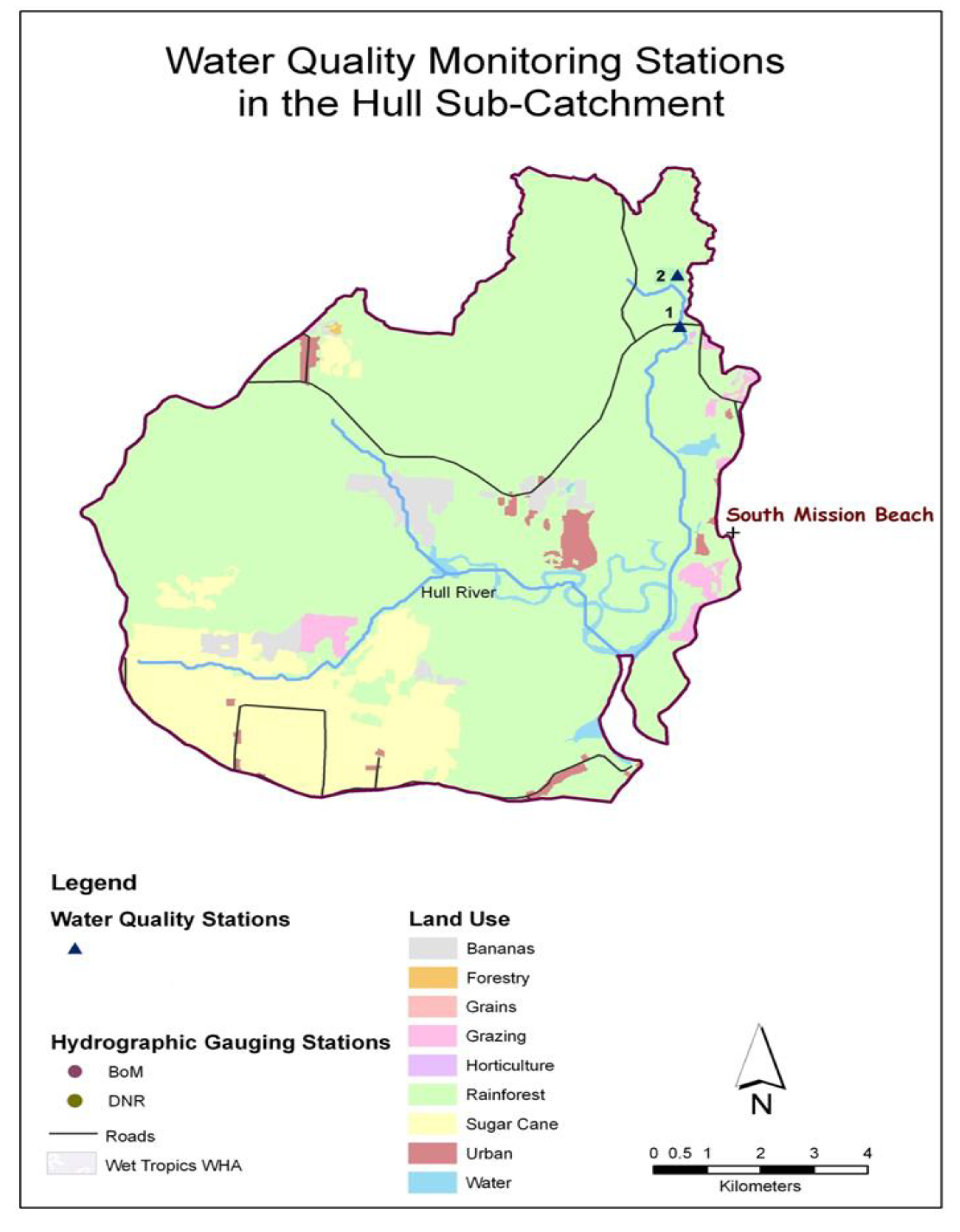
Figure A1. Water quality sampling station locations in the Hull subcatchment.
Water 12 03148 g0a1
Figure A2. Water quality sampling station locations in the Murray subcatchment.
Water 12 03148 g0a2
Figure A3. Water quality sampling station locations in the Tully subcatchment.
Water 12 03148 g0a3

Appendix C. Results from Interviews

Appendix C.1. General Information
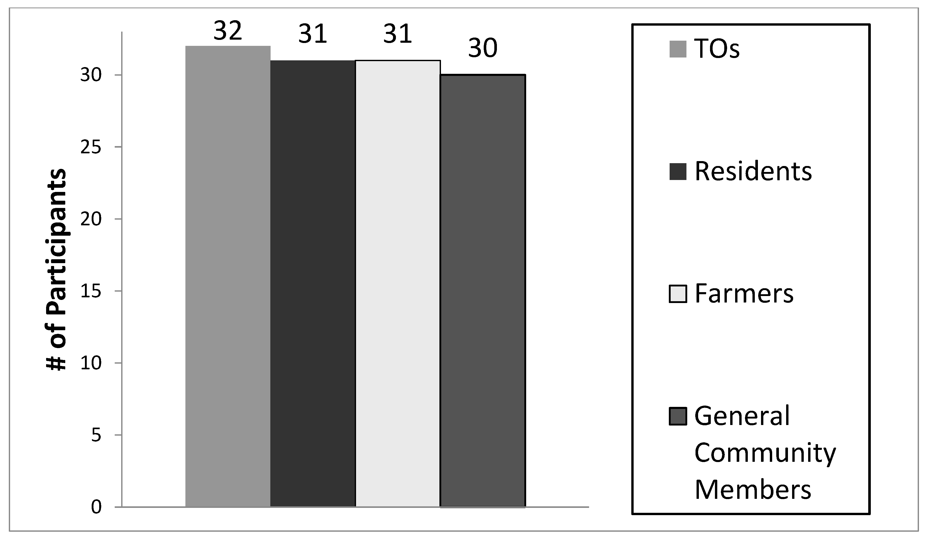
From November 2011 to April 2012, a total of 124 personal interviews with the four key stakeholder groups were conducted by the JCU principal researcher. This breakdown is as follows: 32 Traditional Owner (and other indigenous people living in the basin) interviews; 31 local resident interviews; 31 farmer interviews; and 30 general community member interviews. Figure A4 shows the interview participant numbers by stakeholder group. Of the 124 interviews, 102 participants live in the basin and the remainder (22 interviewees) live outside Tully basin; but frequently work in the basin. The 22 interviewees living outside the basin belonged to the general community members group.
Figure A4. Interview participants by stakeholder group. Total # of Interviews: 124. Total # of Interviewees Living in Basin: 102.
Water 12 03148 g0a4
Generally, the interviews were evenly spread geographically throughout the basin, with 36% of interviewees from the Tully sub-catchment; 43% from the Murray subcatchment; and 21% from the Hull subcatchment (Table A2). In total, more males (68.5%) were interviewed than females (31.5%), except for interviews with stakeholders in the local residents group, where slightly more females were interviewed than males (Table A2). There was a broad representation of interviewees from most age group categories; however, interview participants were mainly aged from their 30 s to their 70 s. Very few interviewees from the Traditional Owners group were aged over 60 years old (6%), whereas, 52% of farmers were over the age of 60 (Table A2). The lack of older Traditional Owner interviewees (>60 years old) may be due to wider health and socio-economic factors.
For stakeholder groups whose members live in the basin (Traditional Owners, farmers and local residents), 59.5% of interviewees have lived in the basin for 30 years or more. Some of these interviewees were born in the basin, and have always lived there. Approximately 71% of farmers stated that they have lived in the basin for more than 30 years (Table A2).
Table A2. Broad characteristics of the interviewees in the Tully Basin.
Traditional
Owners
ResidentsFarmersGeneral Community Members *
Gender
Male22152820
Females1016310
Total 32313130
Age (years)
<21 3100
21–30 6002
31–40 7749
41–50 7264
51–60 71058
>60 211167
Total 32313130
Length of Time Lived in the Basin (years)
<10 2425
10–20 4941
21–30 6430
>30 2014222
Total 3231318
Interviewee’s Primary Residence (#s of interviewees per location)
Tully Basin37
Murray Basin44
Hull Basin21
Outside Basin22
Total124
* 22 general community members do not live in the basin but frequently work in the basin.

Appendix C.2. EV Verification

Environmental Values (EVs) previously identified in the Tully WQIP (2008) included:
  • Drinking water
  • Aquatic ecosystems
  • Recreational opportunities and aesthetic qualities
  • Cultural and spiritual values and access to those sites
  • Primary production and associated industries
While national and state water quality guidelines provide a broad framework regarding the process of identifying environmental values and setting water quality objectives, several EVs and uses identified from the interviews did not fit into the State guideline’s suite of EV categories. This research resulted in finer detail by engaging a wide range of community members to verify existing EVs (from the Tully WQIP), and provided additional opportunities to further elicit uses and values of waterways not found in the guidelines.
The interviews highlighted that most respondents agreed with the existing EVs in the Tully WQIP. Ninety-seven percent (120/124) of interviewees agreed with the Tully WQIP EV list. However, some interviewees stated they would like to add additional EVs to the list (Figure A5). The additional EVs to be added (additional EVs that can be categorised in the 2009 Queensland guidelines suite of EVs) are listed in Figure A5. Figure A5 also indicates waterbody locations for these additional EVs. However, some additional environmental values were also identified during this research but do not fit into established EVs categories in the guidelines.
Terrain NRM (the local NRM body) and the State Department of Environment Heritage and Protection requested the additional EV data from this research (except for the EVs that could not be categorised into the established suite of EVs). Table A1 was incorporated into a consultation report which was completed by Terrain NRM (Terrain 2012) to inform the Wet Tropics Healthy Waters Management Plan (WTHWMP 2020).

Appendix C.3. Additional EVs to be Added

Appendix C.3.1. Summary of Additional EVs to be Added that Can Be Categorised by the Guidelines

Additional EVs (identified from this research) to be added to the Tully WQIP EV list include the following types of EVs:
  • Cultural and spiritual values
  • Human use EVs (consumption of wild or stocked fish/crustaceans, irrigation, farm use, stock watering and aquaculture)
  • Recreation and aesthetics EVs (water for primary and secondary recreation and visual appreciation)
  • Raw drinking water supply
  • Aquatic ecosystems
Figure A5 indicates the specific EVs to be added and basin waterbody locations for these specific EVs. Several interviewees said they would like to add spiritual and cultural EVs to Koombooloomba Dam and Bulgan Creek. Some interviewees felt that Koombooloomba Dam still had spiritual and cultural values even though the waterway had been altered by a hydroelectric dam and reservoir.

Appendix C.3.2. Summary of Additional EVs to Be Added that Are Outside the List of Established EV Categories

The additional EVs that were documented by this research but are outside the list of established EV categories include:
  • Community development (knowledge sharing) uses and values
  • Groundwater values
  • Flooding values
  • Conservation values
  • Tourism values
  • Lost EVs
Similar to findings in the Tully WQIP, some interviewees identified uses/values of waterbodies that had been lost over time (i.e., loss of wetlands and waterbodies) and potential(s) for restoration. Other values included loss of community development values significant to Aboriginal people.
There is no prescribed guideline for cultural and spiritual values, and unlike other EVs, no specific standard has been identified to meet cultural and spiritual values. To address this shortcoming, the NWQMS recommends that managers in cooperation with indigenous people decide how to best account for cultural and spiritual values within their own management frameworks [52]. The absence of a specific water quality guideline for spiritual and cultural values is a shortcoming of the water quality improvement process indicating that Aboriginal people may not be sufficiently represented in water planning initiatives [52].
Previous research has been undertaken in the Tully Basin and in the WHWTA to identify cultural and biophysical indicators with Traditional Owners. In 2005, a paper detailing cultural indicators in the Tully Basin was used as a framework for more recent research (2011) to identify cultural indicators for the WTWHA (described below). A pilot study with the Jumbun community in 2001 identified “an indicator for cultural values” [39] (p. 107). This cultural indicator incorporated a category to “understand history” to recognise the impacts of colonial and post-colonial effects, while acknowledging other aboriginal cultural values” [39] (p. 110). The authors state that these cultural “indicators developed by the Jumbun community cannot automatically be applied everywhere in the Wet Tropics” but the methodology used can be applied elsewhere to identify cultural indicators [39] (p. 110).
Cullen-Unsworth et al. [45] stated that their research used the above study as a framework to identify “linked cultural and biophysical indicators that could be used at local and regional scales in routine monitoring and management of the WTWHA” [44] (p. 185). The authors state that by using a cooperative research approach, “appropriate indicators could be developed to monitor cultural heritage values of ‘country’ and indicators could potentially be coordinated with or integrated into existing local, regional, national and international reporting frameworks” [45] (p. 191). Cullen-Unsworth et al. [45] also stated that regional scale cultural indicators that were developed in this 2011 study (using community case studies in the Wet Tropics) have been “recommended for future planning and management uses in the WTWHA. However, the development of protocols and metrics associated with these cultural indicators are still needed and co-management activities within the Wet Tropics must consider separate Aboriginal cultural identities.” [45] (pp. 191–192).
Figure A5. Additional environmental values (EVs) to be added to the Tully EV list. + This table only includes the additional EVs identified by interviewees that can be categorised in the State of Queensland’s Guidelines’ Suite of EVs.
Water 12 03148 g0a5

Appendix C.4.Water Quality

Results from the interviews also included an assessment of stakeholder perceptions of basin water quality conditions. Perceptions of basin water quality conditions differed between groups, and depended on age, background and uses. Differences may also be due to socio-economic or geographic factors (i.e., where people live) in the basin. Differences in perception may also be due to consumptive versus non-consumptive users of waters. Fifty-three percent of Traditional Owners and 39% of local residents considered basin waterways to be in poor condition. However, approximately 43% of farmers and general community members stated local waterway conditions were good to excellent (Figure A6).
Figure A6. Perceptions of basin water quality conditions by stakeholder group.
Water 12 03148 g0a6
Interviewees were also asked if there were water quality issues or pollutant sources in the basin (Figure A6). All stakeholder groups stated that agricultural activites were sources of water quality issues or pollutants in the basin. More general community members and Traditional Owners groups stated that agricultural activities were sources of water quality issues or pollutant sources in the basin (Figure A7). Other issues and sources listed by interviewees included sediment, erosion and urban areas. More farmers (than other stakeholder groups interviewed) stated that sediment and erosion were water quality issues or sources of pollutants in the basin than other groups. As well, more general community members listed urban areas than did other groups. A few interviewees stated that cyclones, climate change, floods, roads and pigs were sources of pollutants or water quality issues in the basin, however, this number was quite low. Findings indicated that stakeholders hold a range of views in regards to water quality issues and pollutant sources in the basin. However, all groups interviewed stated that agricultural activities were sources of water quality issues or pollutant sources in this basin.
Figure A7. Perceptions of water quality issues/pollutant sources in the basin.
Water 12 03148 g0a7
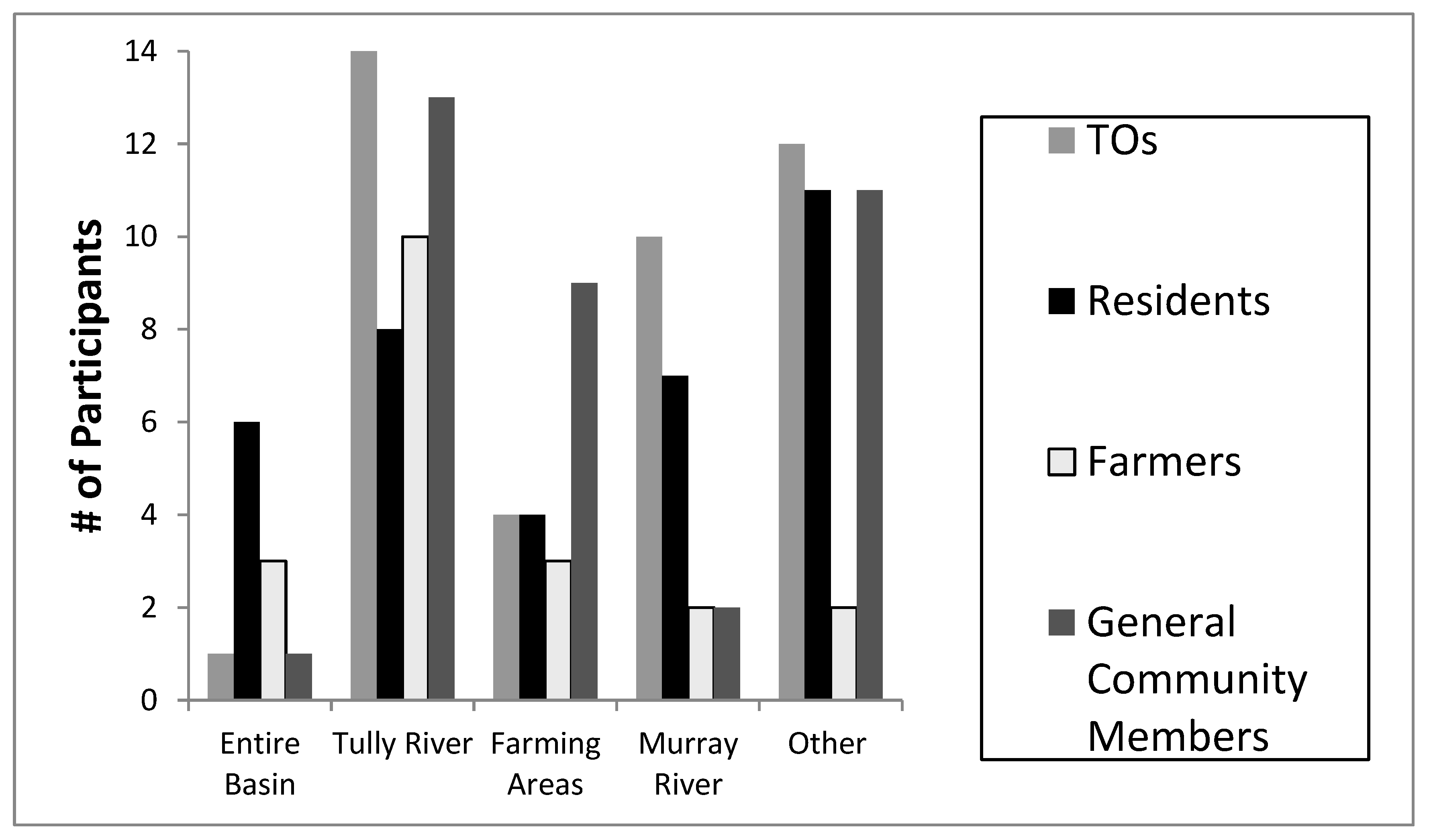
Interviewees were also asked if there were water quality hot spots or priorty areas in the basin (Figure A8). Traditional Owners and local residents listed the Tully and Murray Rivers and other specific locations (i.e., tributaries or areas around Mission Beach) in the basin. Some local residents also stated that the entire basin was a hot spot or priority area. Farmers mainly listed the Tully River as a hot spot or priority area, while more general community members listed farming areas as hot spots/priority areas than did other groups.
Figure A8. Number of participants who expressed comments about hot spots or priority areas in the basin.
Water 12 03148 g0a8
Interview results also highlighted potential human health concerns in the basin. A large percentage of stakeholders living in the basin stated they regularly drink untreated water from local waterways. Ninety-seven percent of Traditional Owners, 65% of farmers, and 61% of local residents said they drink directly from basin waterways when participating in recreational activities (e.g., fishing, camping and hiking) (Figure A9). If potential human health concerns or risks exist (i.e., if there are high levels of pesticides or herbicides in basin waterways), regular water quality monitoring should be established throughout the basin, and locals should be appropriately informed of the results.
Figure A9. Participant #’s (by stakeholder group) that drink untreated water from basin waterways.
Water 12 03148 g0a9
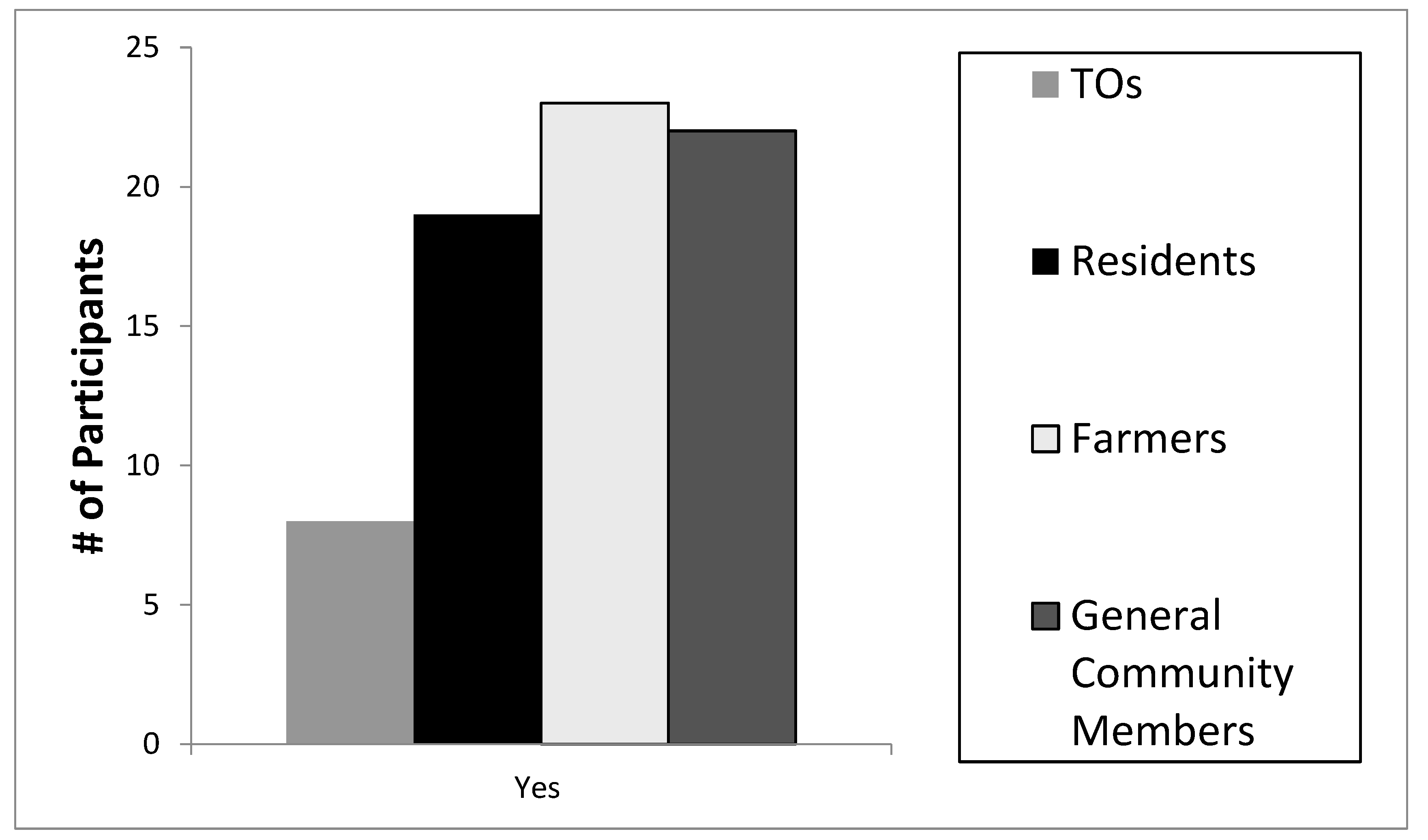
Interviewees were also asked if they knew of any recent water quality reports for the GBR (i.e., the GBR baseline report, 1st Report Card based on water quality data from 2009; or pesticide reports). Only 38% percent of Traditional Owners knew of these water quality reports while 68% of local residents, 77% of farmers and 73% of general community members knew of these reports (Figure A10). The lower percentage of Traditional Owners knowing about these reports may be due to a lack of effective communication or consultation by government agencies, whereas other stakeholders (farmers) have been engaged by government agencies over a longer timeframe in basin water quality programs, and are involved in initiatives such as the Paddock to Reef program.
Figure A10. Knowledge of water quality reports for the Great Barrier Reef (GBR).
Water 12 03148 g0a10
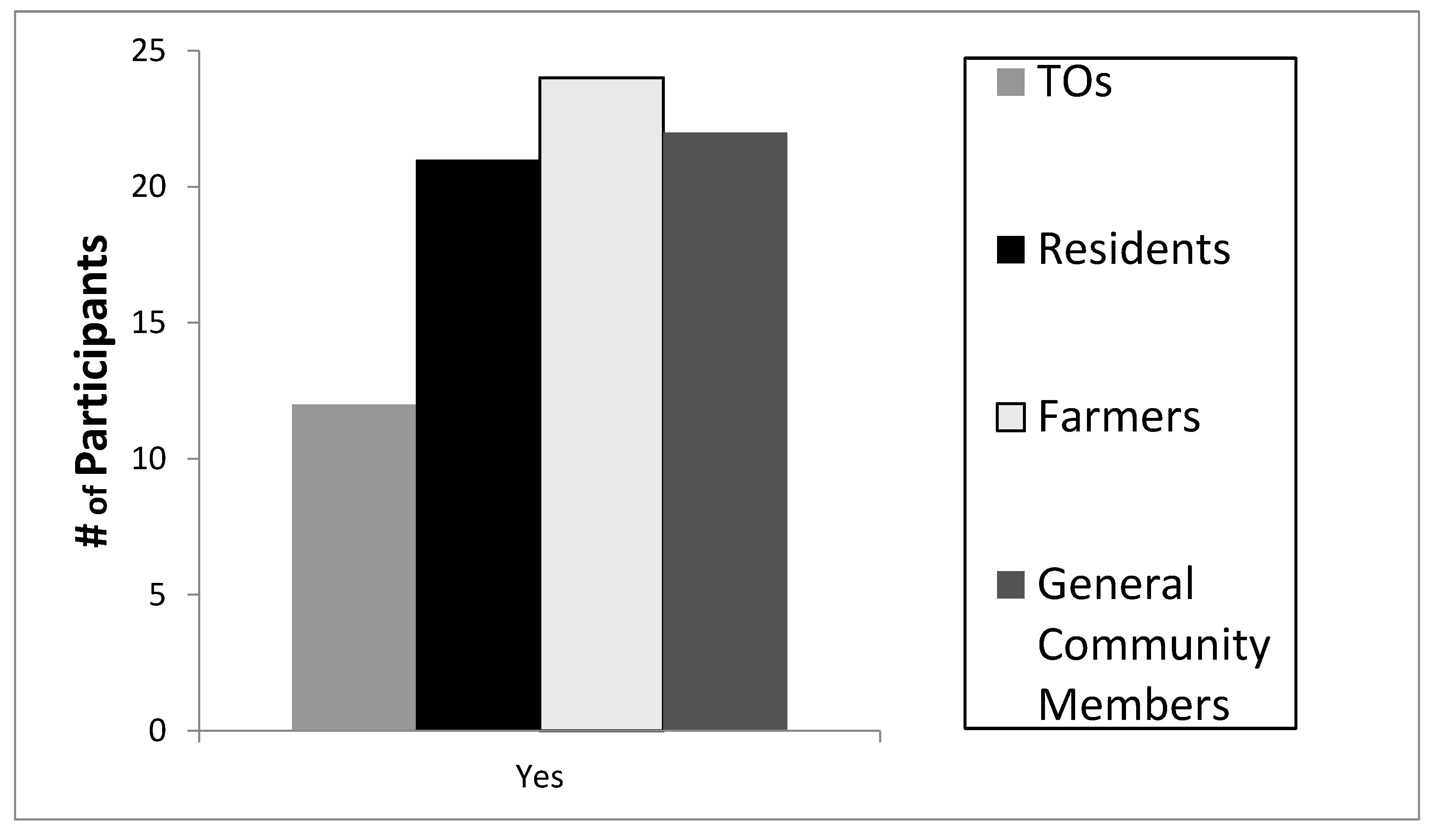
Interviewees were also asked if they knew of any water quality monitoring programs in the basin. Only 25% percent of Traditional Owners knew of these programs, while 61% of local residents, 74% of farmers and 73% of general community members knew of these programs (Figure A11). The lower percentage by Traditional Owners may also be due to a lack of effective communication/consultation by government agencies. In contrast, other stakeholders (farmers) have been engaged by government agencies in water quality monitoring programs (i.e., plot scale studies) aimed at improving water quality delivery to the GBR.
Figure A11. Knowledge of basin water quality monitoring programs.
Water 12 03148 g0a11
Interviewees were also asked what should be sampled in a water quality monitoring program for this basin. All stakeholder groups stated that chemicals used in agriculture (e.g., pesticides and herbicides) should be included in a monitoring program (Figure A12). In addition, a higher number of Traditional Owners stated they would like fish and other aquatic life be included. This higher response rate by Traditional Owners may be due to their greater dependence on local aquatic food sources to supplement their dietary needs than other groups. In addition, indigenous people interact and educate children in the protocols of fishing and hunting while carrying out custodial responsibilities to look after cultural sites and carrying out customary management activities.
All stakeholder groups listed sediment, soils, and turbidity to be included in a water quality monitoring program. However, a higher number of farmers and general community members groups listed this category than other groups. Additionally, more local residents listed bacteria than other groups. This may be due to stormwater runoff concerns in more developed areas of the basin. General community members, farmers and residents also listed nutrients to be included in a monitoring program. Farm drains and lagoons were also listed by various stakeholder groups.
Figure A12. Water quality parameters to be sampled.
Water 12 03148 g0a12
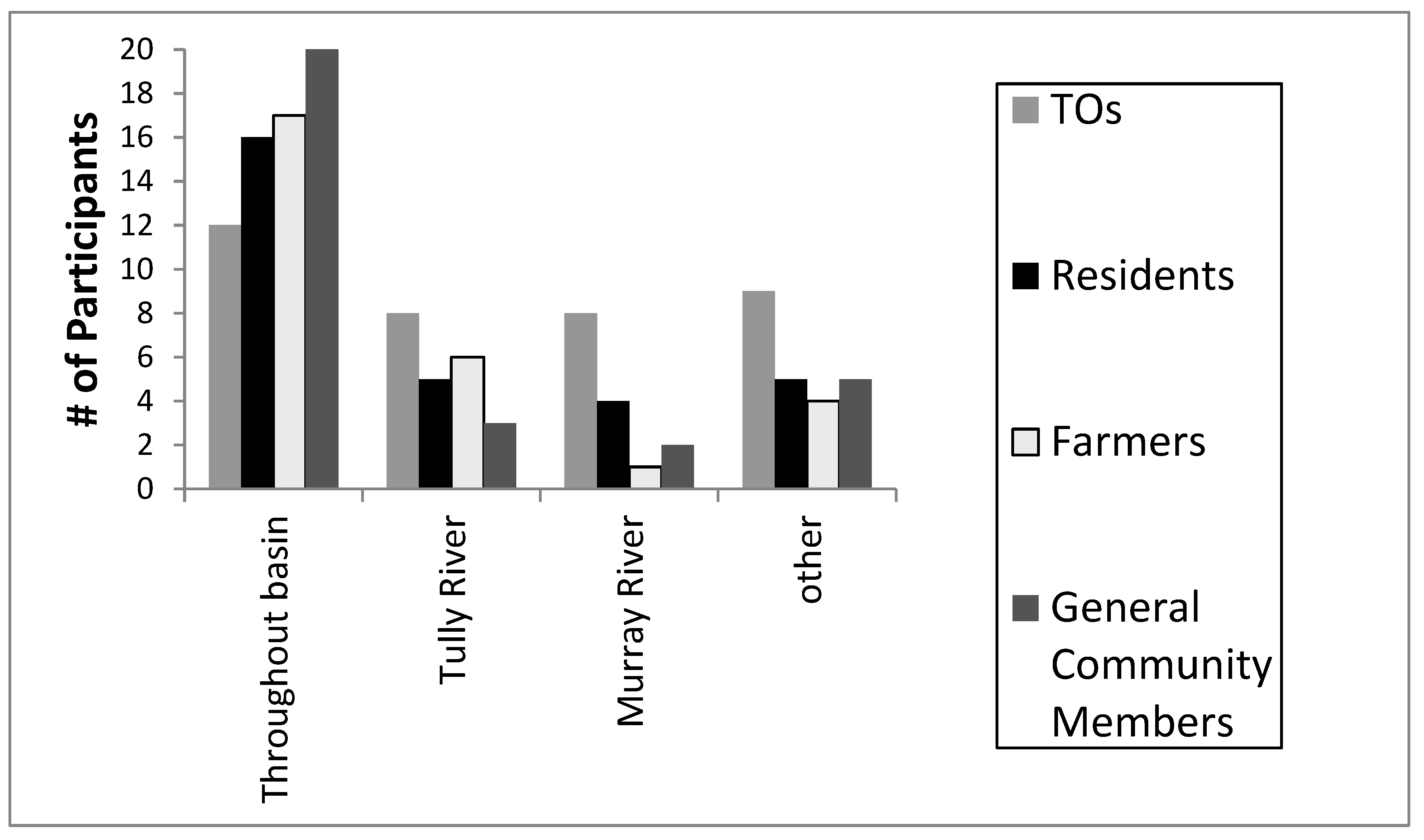
Interviewees were also asked where should water quality sampling activities be located in the basin (Figure A13). All stakeholder groups stated that sampling should be located throughout the basin. In addition, some stakeholders specifically listed the Tully and Murray Rivers as well listing other specific locations in the basin.
Figure A13. Suggestions for sampling locations in the basin.
Water 12 03148 g0a13
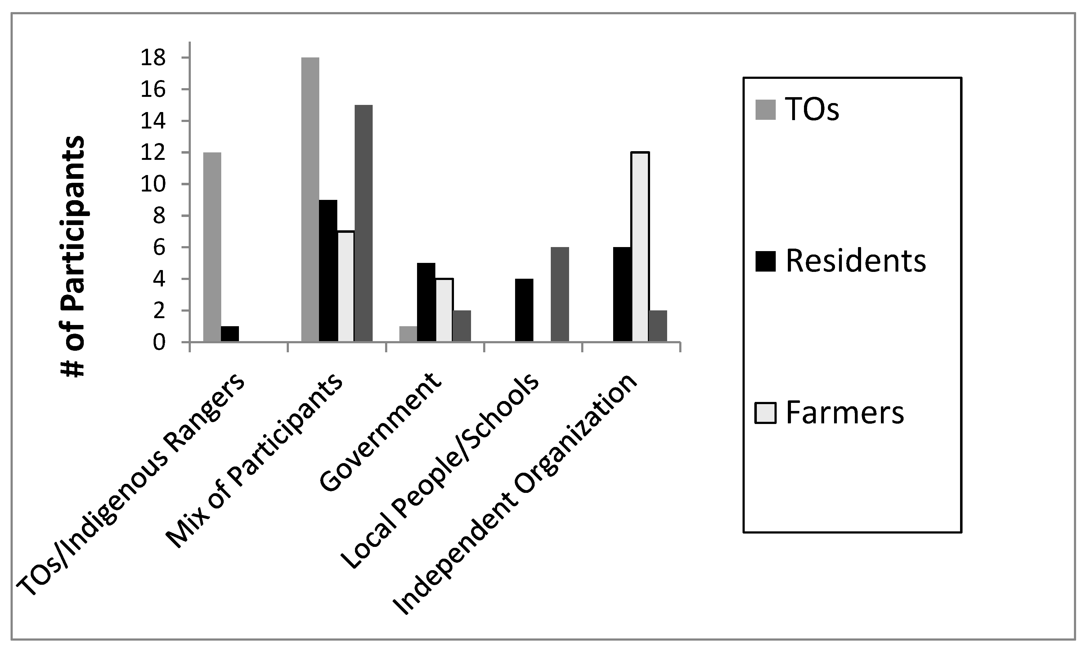
Interviewees were also asked who should conduct water quality sampling activities in the basin (Figure A14). Participants from all stakeholder groups suggested that a mix of participants (e.g., government, universities, industry, local residents and Traditional Owners) should be involved in a sampling program for this basin. Some Traditional Owners specifically stated they would like indigenous people (including the Girringun Indigenous Rangers) to conduct water quality sampling activities in this basin. This high response rate from Traditional Owners may be due to their cultural obligations to water on their country. A higher number of farmers (than other stakeholder groups) suggested an independent organisation should conduct water quality sampling in this basin. This suggestion may be due to recent water quality reports suggesting agricultural activities are main sources of pollutants to GBR, and farmers would like other organisations (other than the government) to conduct these sampling activities.
Figure A14. Suggestions for who should conduct sampling activities in the basin.
Water 12 03148 g0a14

Appendix C.5. Summary of the Key Interview Results

Results from the interviews assisted in verifying EVs from the Tully WQIP, and also identified EVs to add to this list. Several interviewees said they would like to add spiritual and cultural EVs to Koombooloomba Dam, even though the waterway had been altered by a hydroelectric dam and reservoir.
Additional EVs from this research also included EVs that cannot be categorised in the State of Queensland’s current suite of EVs. These additional EVs that fall outside this established suite may be overlooked or not included as EVs when WQOs are being refined for this basin. There needs to be a better process to account for all EVs, not just the ones that fall within the established suite of EVs.
Interview results also assisted in better understanding key differences and similarities of stakeholder perceptions of water quality conditions, hot spot areas, pollutant sources and water quality issues in the basin. Perceptions of water quality conditions differed between groups and depended upon age, background and water uses. These differences may also be due to socio-economic or geographic factors (i.e., where people live in the basin). The differences in perception may also be due to consumptive versus non-consumptive users of water and may indicate potential conflicts between these groups.
All stakeholder groups stated that agricultural activities were sources of water quality issues or pollutant sources in the basin, however, more Traditional Owners and general community members’ listed agricultural activities as sources of water quality issues or pollutant sources than did other groups. More general community members also listed urban areas as water quality issues or pollutant sources than did other groups. Overall, findings indicated that stakeholders hold a range of views in regards to their perceptions of water quality issues or pollutant sources in the basin. However, all groups interviewed stated that agricultural activities were sources of water quality issues or pollutant sources in the basin.
Perceptions of hot spots or priority areas in the basin also varied between groups. The Tully and Murray Rivers were listed by all stakeholder groups as a hot spot or priority area in the basin; however, other specific areas (i.e., tributaries or areas around Mission Beach) were also listed. Several local residents stated the entire basin was a hot spot or priority area and more general community members listed farming areas as hot spot or priority areas than did other groups.
From a human health perspective, interview results indicated that stakeholders living in the basin are drinking untreated water directly from basin waterbodies. If there are water quality issues or concerns in this basin (i.e., high levels of herbicides and pesticides), and if these waterbodies are not regularly being monitored or results not being effectively communicated to the public, there may be a potential human health concern. Locals should be informed of any potential human health issues if there is one in the basin.
Interview results also highlighted that Traditional Owners are much less aware of GBR water quality reports and water quality monitoring programs than other groups. Improved communication and consultation by government agencies may be needed to better communicate this information to this stakeholder group.
There was some agreement between stakeholder groups regarding water quality parameters to be sampled in a basin water quality monitoring program, and basin locations for these sampling activities. All stakeholder groups stated that chemicals used in agriculture should be sampled as part of a water quality monitoring program. In addition, Traditional Owners stated they would like fish and other aquatic life be sampled as part of a water quality monitoring program. This higher response rate by Traditional Owners may be due to their greater dependence on aquatic food sources to supplement their dietary needs than other groups. In addition, all groups interviewed had more of their members stating that water quality sampling activities should be located throughout the basin than any other response.
There was also agreement between groups regarding who should be involved in basin water quality sampling activities. All stakeholder groups suggested that a mix of participants (e.g., government, universities, industry, local residents and Traditional Owners) should be involved in a sampling program for this basin. However, more farmers suggested an independent organisation should conduct water quality sampling activities in this basin. This response may be due to government reports suggesting agricultural activities are main sources of pollutants to basin waterways and to the GBR. Some Traditional Owners stated that Traditional Owners/Girringun Indigenous Rangers should conduct sampling activities in this basin. This response may be due to their cultural obligations to water on their country.

References

  1. McDonald, G.; Weston, N. Sustaining the Wet Tropics: A Regional Plan for Natural Resource Management. Background to the Plan; Rainforest CRC and FNQ NRM Ltd.: Cairns, Australia, 2004. [Google Scholar]
  2. Bohnet, I.; Smith, D.M. Planning future landscapes in the Wet Tropics of Australia: A social-ecological framework. Landsc. Urban Plan. 2007, 80, 137–152. [Google Scholar] [CrossRef]
  3. Terrain, N.R.M. Wet Tropics Water Quality Improvement Plan: 2015–2020. Available online: https://terrainnrm.maps.arcgis.com/apps/MapSeries/index.html?appid=a0184c53739c482496b42cca599a89c2 (accessed on 28 August 2020).
  4. Department of Environment, Water, Heritage, and the Arts (DEWHA). Caring for Our Country Outcomes 2008–2013; DEWHA: Canberra, Australia, 2009. [Google Scholar]
  5. Terrain, N.R.M. Summary of the Tully Water Quality Improvement Plan. Available online: www.terrain.org.au (accessed on 28 August 2020).
  6. Brodie, J.; Mitchell, A. Sediments and Nutrients in North Queensland Tropical Streams: Changes with Agricultural Development and Pristine Condition Status; CRC Reef Research Centre: Townsville, Australia, 2006; pp. 81–100. [Google Scholar]
  7. Tsatsaros, J.H.; Brodie, J.E.; Bohnet, I.C.; Valentine, P. Water Quality Degradation of Coastal Waterways in the Wet Tropics, Australia. Water Air Soil Pollut. 2013, 224, 1443. [Google Scholar] [CrossRef]
  8. Australian Government. Reef 2050 Water Quality Improvement Plan 2017–2022. 2018. Available online: https://www.reefplan.qld.gov.au/__data/assets/pdf_file/0017/46115/reef-2050-water-quality-improvement-plan-2017-22.pdf (accessed on 28 August 2020).
  9. Schulz, Martin-Ortega & Glenk. Value landscapes and their impact on public water policy preferences. Glob. Environ. Chang. 2018, 53, 209–224. [Google Scholar] [CrossRef]
  10. State of Queensland, Department of Environment and Heritage Protection (EHP). Queensland Water Quality Guidelines 2009. 2013. Available online: https://www.hort360.com.au/wordpress/uploads/Irrigation/Irrigation%20Sustainability/Qld%20Water%20Quality%20Guidelines%202009.pdf (accessed on 26 September 2020).
  11. Australian Government Charter. National Water Quality Management Strategy; CCBY3.0; Department of Agriculture and Water Resources: Canberra, Australia, 2018. Available online: https://www.waterquality.gov.au/sites/default/files/documents/nwqms-charter.pdf (accessed on 26 September 2020).
  12. State of Queensland, Environmental Policy and Planning Division, Department of Environment and Heritage Protection. Environmental Protection (Water) Policy 2009 Tully, Murray and Hinchinbrook Is. River Basins Environmental Values and Water Quality Objectives—Basins Nos. 113, 114 and 115 and Adjacent Coastal Waters. 2014. Available online: https://environment.des.qld.gov.au/__data/assets/pdf_file/0020/89012/tully-murray-hinchinbrook-evs-wqos.pdf (accessed on 26 September 2020).
  13. Lewis, S.E.; Brodie, J.E. A Water Quality Issues Analysis for the Johnstone River Basin; Report # 11/05 for Terrain NRM; Australian Centre for Tropical Freshwater Research, James Cook University: Townsville, Australia, 2011. [Google Scholar]
  14. Lewis, S.E.; Brodie, J.E. A Water Quality Issues Analysis for the Mulgrave River Catchment; Report #11/06 for Terrain NRM; Australian Centre for Tropical Freshwater Research, James Cook University: Townsville, Australia, 2011. [Google Scholar]
  15. Lewis, S.E.; Brodie, J.E. A Water Quality Issues Analysis for the Russell River Catchment; Report # 11/07 for Terrain NRM; Australian Centre for Tropical Freshwater Research, James Cook University: Townsville, Australia, 2011. [Google Scholar]
  16. Kroon, F.J.; Brodie, J.E. Catchment management and health of coastal ecosystems: Synthesis and future research. Mar. Freshw. Res. 2009, 60, 1196–1200. [Google Scholar] [CrossRef]
  17. Moss, A.; Brodie, J.; Furnas, M. Water quality guidelines for the Great Barrier Reef World Heritage Area: A basis for development and preliminary values. Mar. Freshw. Res. 2005, 51, 76–88. [Google Scholar] [CrossRef]
  18. Tsatsaros, J.H. Refining Water Quality Objectives and Monitoring in the Wet Tropics Using a Community Based Approach. Ph.D. Thesis, James Cook University, Townsville, Australia, 2013. [Google Scholar]
  19. Bohnet, I.; Kinjun, C. Community uses and values of water informing water quality improvement planning: A study from the Great Barrier Reef region, Australia. Mar. Freshw. Res. 2009, 60, 1176–1182. [Google Scholar] [CrossRef] [Green Version]
  20. Tsatsaros, J.H.; Brodie, J.E.; Bohnet, I.C.; Valentine, P. A Trans-Disciplinary Approach for Refining Water Quality Objectives in the Wet Tropics, Australia. In Peer-Reviewed Conference Paper. Transboundary Water Management Across Borders and Interfaces (TWAM) International Conference and Workshops–Conference Proceedings; Roebeling, P.C., Rocha, J., Teotónio, C., Alves, H., Almeida, P., Eds.; CESAM–Department of Environment & Planning, University of Aveiro: Aveiro, Portugal, 2013; ISBN 978-972-789-378-2. [Google Scholar]
  21. Bohnet, I.; Kinjun, C.; Roberts, B. Community Uses and Values in Waters in the Tully-Murray Catchment; First Milestone Report for Far North Queensland Natural Resources Management (FNQ NRM): Canberra, Australia, 2006. [Google Scholar]
  22. Bohnet, I.; Kinjun, C.; Haug, K.; Kroon, F.; Sydes, D.; Pert, P.; Roberts, B. Community Uses and Values in Waters in the Tully-Murray Catchment; Final Report for Far North Queensland Natural Resource Management (FNQ NRM Ltd.): Cairns, Australia, 2007. [Google Scholar]
  23. Faithful, J.; Brodie, J.; Bainbridge, Z.; Schaffelke, B.; Slivkoff, M.; Maughan, M.; Liessmann, L.; Sydes, D. Water Quality Characteristics of Water Draining Different Land Uses in the Tully/Murray Rivers Region-Edition 2 for the Terrain Water Quality Improvement Plan; ACTFR Report: No. 08/03; James Cook University: Townsville, Australia, 2008. [Google Scholar]
  24. Devlin, M.; Schaffelke, B. Spatial extent of riverine flood plumes and exposure of marine ecosystems in the Tully coastal region, Great Barrier Reef. Mar. Freshw. Res. 2009, 60, 1109–1122. [Google Scholar] [CrossRef]
  25. Webster, A.J.; Thorburn, P.J.; Roebeling, P.C.; Horan, H.L.; Biggs, J.S. The expected impact of climate change on nitrogen losses from wet tropical sugarcane production in the Great Barrier Reef region. Mar. Freshw. Res. 2009, 60, 1159–1164. [Google Scholar] [CrossRef] [Green Version]
  26. Faithful, J.; Finlayson, W. Water quality assessment for sustainable agriculture in the Wet Tropics-A community assisted approach. Mar. Pollut. Bull. 2005, 51, 99–112. [Google Scholar] [CrossRef]
  27. Brodie, J.; Lewis, S.; Bainbridge, Z.; Mitchell, A.; Waterhouse, J.; Kroon, F. Target setting for pollutant discharge management of rivers in the Great Barrier Reef catchment area. Mar. Freshw. Res. 2009, 60, 1141–1149. [Google Scholar] [CrossRef] [Green Version]
  28. Queensland Government Statistician’s Office. Queensland Treasury, Queensland Regional Profiles: Resident Profile for Tully Statistical Area Level 2 (QGSO). 2020. Available online: https://statistics.qgso.qld.gov.au/qld-regional-profiles (accessed on 28 August 2020).
  29. Gruber, J. Perspectives of effective and sustainable community-based natural resource management: An application of Q methodology to forest projects. Conserv. Soc. 2011, 9, 159–171. [Google Scholar] [CrossRef]
  30. Carlson, T.; Cohen, A. Linking Community-based monitoring to water policy: Perceptions of citizen scientists. Environ. Manag. 2018, 219, 168–177. [Google Scholar] [CrossRef]
  31. Hill, R. Towards Equity in Indigenous co-management of protected areas: Cultural planning by Miriuwung-Gajerrong people in the Kimberley, Western Australia. Geogr. Res. 2010, 49, 72–85. [Google Scholar] [CrossRef]
  32. Wilson, N.J.; Mutter, E.; Inkster, J.; Satterfield, T. Community-based monitoring as the practice of Indigenous governance: A case study of Indigenous-led water quality monitoring in the Yukon River Basin. Environ. Manag. 2018, 210, 290–298. [Google Scholar] [CrossRef]
  33. Behmel, S.; Damour, M.; Ludwig, R.; Rodriguez, M.J. Participative approach to elicit water quality needs from stakeholder groups-An application of integrated watershed management. J. Environ. Manag. 2018, 218, 540–554. [Google Scholar] [CrossRef] [PubMed]
  34. Brodie, J.; Kroon, F.; Schaffelke, B.; Wolanski, E.; Lewis, S.; Devlin, M.; Bohnet, I.C.; Bainbridge, Z.; Waterhouse, J.; Davis, A. Terrestrial pollutant runoff to the Great Barrier Reef: Current issues, priorities, and management responses. Mar. Pollut. Bull. 2012, 65, 81–100. [Google Scholar] [CrossRef]
  35. Bohnet, I.C. Integrating social and ecological knowledge for planning sustainable land- and seascapes: Experiences from the Great Barrier Reef region, Australia. Landsc. Ecol. 2010, 25, 1201–1218. [Google Scholar] [CrossRef]
  36. Hatfield-Dodds, S.; Syme, G.J.; Leitch, A. Improving Australian water management: The contribution of social values research and community engagement. Reform 2006, 89, 44–48. [Google Scholar]
  37. Hophmayer-Tokich, S.; Krozer, Y. Public participation in rural area management: Experiences from the North Sea countries in Europe. Water Int. 2008, 33, 243–257. [Google Scholar] [CrossRef]
  38. Luz, F. Participatory landscape ecology-a basis for acceptance and implementation. Landsc. Urban Plan. 2000, 50, 157–166. [Google Scholar] [CrossRef]
  39. Evely, A.; Fazey, I.; Pinard, M.; Lambin, X. The influence of philosophical perspectives in integrative research: A conservation case study in the Cairngorms National Park. Ecol. Soc. 2008, 13, 52. [Google Scholar] [CrossRef] [Green Version]
  40. McLeod, C.; Blackstock, K.; Haygarth, P. Mechanisms to improve integrative research at the science-policy interface for sustainable catchment management. Ecol. Soc. 2008, 13, 48. [Google Scholar] [CrossRef]
  41. Hochtl, F.; Lehringer, S.; Konold, W. Pure theory or useful tool? experiences with transdisciplinary in the Piedmont Alps. Environ. Sci. Policy 2006, 9, 322–329. [Google Scholar] [CrossRef]
  42. Tress, G.; Tress, B.; Fry, G. Clarifying integrative research concepts in landscape ecology. Landsc. Ecol. 2005, 20, 479–493. [Google Scholar] [CrossRef]
  43. Kroon, F.J.; Robinson, C.J.; Dale, A.P. Integrating knowledge to inform water quality planning in the Tully–Murray basin. Australia. Mar. Freshw. Res. 2009, 60, 1183–1188. [Google Scholar] [CrossRef]
  44. Lang, D.J.; Wiek, A.; Bergmann, M.; Stauffacher, M.; Martens, P.; Moll, P.; Swilling, M.; Thomas, C.J. Transdisciplinary research in sustainability science: Practice, principles, and challenges. Sustain. Sci. 2012, 7, 25. [Google Scholar] [CrossRef]
  45. Cullen-Unsworth, L.C.; Hill, R.; Butler, J.R.A.; Wallace, M. Development of Linked Cultural and Biophysical Indicators for the Wet Tropics World Heritage Area. Int. J. Sci. Soc. 2011, 2, 181–194. [Google Scholar] [CrossRef]
  46. Bark, R.H.; Barber, M.; Jackson, S.; Maclean, K.; Pollino, C.; Moggridge, B. Operationalising the ecosystem services approach in water planning: A case study of indigenous cultural values from the Murray–Darling Basin, Australia. Int. J. Biodivers. Sci. Ecosyst. Serv. Manag. 2015, 11, 239–249. [Google Scholar] [CrossRef]
  47. Lingiari Foundation and the North Australian Indigenous Land and Sea Management Alliance (NAILSMA). An Overview of Indigenous Rights in Water Resources Management; North Australian Indigenous Land and Sea Management Alliance on behalf of the Indigenous Water Policy Group: Darwin, Australia, 2008. [Google Scholar]
  48. North Australian Indigenous Land and Sea Management Alliance (NAILSMA) and the Commonwealth Scientific and Industrial Research Organization (CSIRO). Indigenous Interests and the National Water Initiative (NWI): Water Management, Reform and Implementation; North Australian Indigenous Land and Sea Management Alliance: Darwin, Australia, 2007. [Google Scholar]
  49. Swanwick, C. Land Use Consultants, Landscape Character Assessment—Guidance for England and Scotland, The Countryside Agency and Scottish Natural Heritage, Wetherby, West Yorkshire and Edinburgh; The Countryside Agency and Scottish Natural Heritage: Sheffield, UK, 2002. [Google Scholar]
  50. Kasemir, B.; Jaeger, J.; Jaeger, C.C.; Gardner, M.T. Public Participation in Sustainability Science—A Handbook; Cambridge University Press: Cambridge, UK, 2003. [Google Scholar]
  51. Bohnet, I.; Brodie, J.; Bartley, R. Assessing water quality impacts of community defined land use change scenarios for the Douglas Shire, Far North. In Landscape Analysis and Visualization; Pettit, C., Cartwright, W., Bishop, I., Lowell, K., Pullar, D., Duncan, D., Eds.; Springer: Berlin, Germany, 2008; pp. 383–406. [Google Scholar] [CrossRef]
  52. Bohnet, I.C. Lessons Learned from Public Participation in Water Quality Improvement Planning: A Study from Australia. Soc. Nat. Resour. 2015, 28, 180–196. [Google Scholar] [CrossRef]
  53. Patterson, J.J.; Smith, C.; Bellamy, J. Understanding enabling capacities for managing the ‘wicked problem’ of nonpoint source water pollution in catchments: A conceptual framework. J. Environ. Manag. 2013, 128, 441–452. [Google Scholar] [CrossRef]
  54. Jager, N.W.; Challies, E.; Kochskamper, E.; Newig, J.; Benson, D.; Blackstock, K.; von Korff, Y. Transforming European Water Governance? Participation and River Basin Management under the EU Water Framework Directive in 13 Member States. Water 2016, 8, 156. [Google Scholar] [CrossRef]
  55. Kochskamper, E.; Challies, E.; Newig, J.; Jager, N.W. Participation for effective environmental governance? Evidence from Water Framework Directive implementation in Germany, Spain and the United Kingdom. J. Environ. Manag. 2016, 181, 737–748. [Google Scholar] [CrossRef] [PubMed]
  56. Miles, M.B.; Huberman, A.M. Qualitative Data Analysis, 2nd ed.; Sage: London, UK, 1994. [Google Scholar]
  57. Guest, G.; MacQueen, K.M. (Eds.) Handbook for Team Based Qualitative Research; Altamira Press: Plymouth, UK, 2008. [Google Scholar]
  58. Filion, F.L. Human surveys in wildlife management. In Wildlife Management Techniques Manual, 4th ed.; Schemnitz, E.D., Ed.; The Wildlife Society: Washington, DC, USA, 1980; pp. 441–453. [Google Scholar]
  59. Januchowski-Hartley, S.R.; Moon, K.; Stoeckl, N.; Gray, G. Social factors and private benefits influence landholders riverine restoration priorities in tropical Australia. J. Environ. Manag. 2012, 110, 20–26. [Google Scholar] [CrossRef]
  60. Zurba, M.; Ross, H.; Izurieta, A.; Rist, P.; Bock, E.; Berkes, F. Building co-management as a process: Problem solving through partnerships in aboriginal country, Australia. Environ. Manag. 2012, 49, 1130–1142. [Google Scholar] [CrossRef]
  61. Girringun Aboriginal Corporation, Bandjin, Djiru, Girramay, Gugu Badhun, Gulnay, Nywaigi, Warrgamay and Warungnu Traditional Owners, Regional Advisory, and Innovation Network (RAIN) Pty. Girringun Region Indigenous Protected Areas Management Plan (GRIPA); Girringun Aboriginal Corporation: Cardwell, Australia, 2013. [Google Scholar]
  62. Nancarrow, K. Hope for Declaration to Boost Indigenous Protected Area. ABC Network (June 11, 2013). Available online: http://www.abc.net.au/news/2013-06-11/hope-for-declaration-to-boost-indigenous-protected-area/4745298/?site=indigenous&topic=latest (accessed on 28 August 2020).
  63. State of Queensland Indigenous Land and Sea Ranger Program. Available online: https://apps.des.qld.gov.au/land-sea-rangers/?ranger=cardwell (accessed on 2 October 2020).
  64. Behmel, S.; Damour, M.; Ludwig, R.; Rodriguez, M.J. Water quality monitoring strategies-A review and future perspectives. Sci. Total Environ. 2016, 571, 1312–1329. [Google Scholar] [CrossRef] [PubMed]
  65. Tsatsaros, J.H.; Wellman, J.L.; Bohnet, I.C.; Brodie, J.E.; Valentine, P. Indigenous Water Governance in Australia: Comparisons with the United States and Canada. Water 2018, 10, 1639. [Google Scholar] [CrossRef] [Green Version]
  66. Smyth, D.; Beeron, C. Development of cultural indicators for the management of the Wet Tropics World Heritage Area. In The Power of Knowledge, the Resonance of Tradition 2005; Ward, G., Muckl, A., Eds.; Electronic Publication of Papers from the AIATSIS Indigenous Studies Conference: Canberra, Australia, 2001. [Google Scholar]
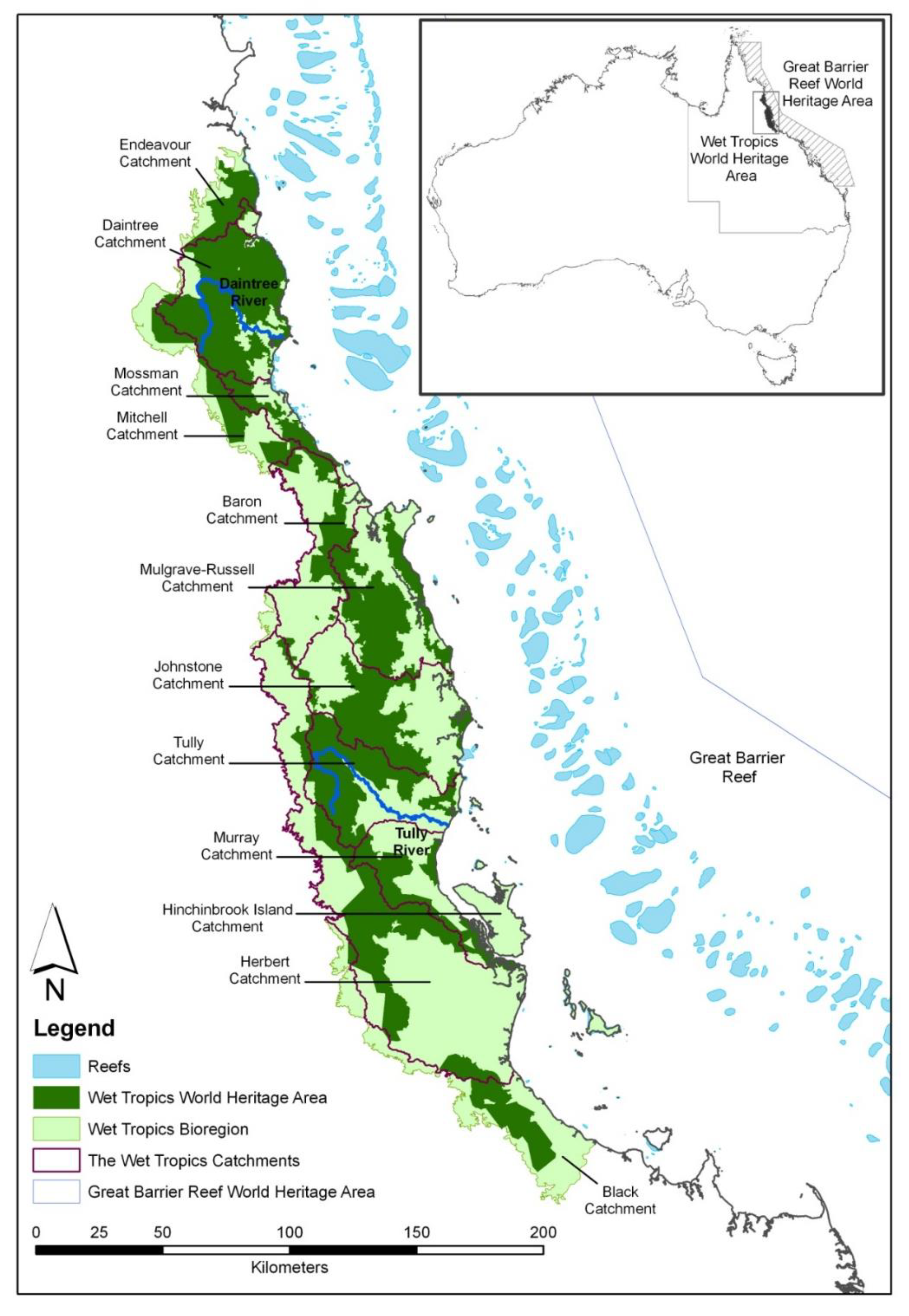
Figure 1. Location of the Tully Basin in Queensland, Australia [18].
Water 12 03148 g001
Figure 2. Conceptual framework for revising freshwater Water Quality Objectives (WQOs) using biophysical and social knowledge (Tsatsaros [18]) * adapted and modified from Bohnet [18,35]. Black arrow on the right shows the process is not unidirectional but may involve iterative processes.
Water 12 03148 g002
Table 1. Overview of the Pilot Water Quality Monitoring Program for the Tully Basin.
ParameterFrequencyLocationSample Dates (2012)
Total Suspended Solids (TSS)Once a month
(3 times in total)
All 15 stationsMay, June, July
TurbidityOnce a month
(3 times in total)
All 15 stationsMay, June, July
Pesticides (herbicides--Atrazine, Diuron, Hexazinone)OnceThree locations May
Total and Dissolved Nutrients (FRP, NH3, NO3, TDN, TDP, TN, TP) *TwiceAll 15 stationsMay, July
Faecal Coliform BacteriaOnceThree locations May
Probable Source(s) and Site Condition Class Field FormOnce a month
(3 times in total)
All 15 stationsMay, June, July
Stream Condition Field Form (visual assessment)Once a month
(3 times in total)
All 15 stationsMay, June, July
Supplemental Field Form (including streamflow measurements)Once a month
(3 times in total)
All 15 stationsMay, June, July
* FRP (filterable reactive phosphorus); NH3 (Ammonia); NO3 (Nitrate); TDN (Total Dissolved Nitrogen); TDP (Total Dissolved Phosphorus); TN (Total Nitrogen); TP (Total Phosphorus).
Publisher’s Note: MDPI stays neutral with regard to jurisdictional claims in published maps and institutional affiliations.